Bridge Statistics for La Porte, Indiana (IN)
Condition, Traffic, Stress, Structural Evaluation, Project Costs
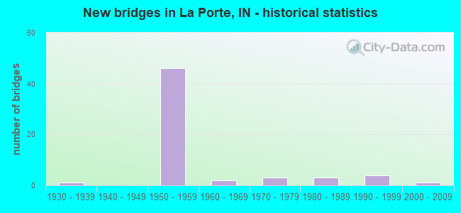
- New bridges - historical statistics
- 11930-1939
- 461950-1959
- 21960-1969
- 31970-1979
- 31980-1989
- 41990-1999
- 12000-2009
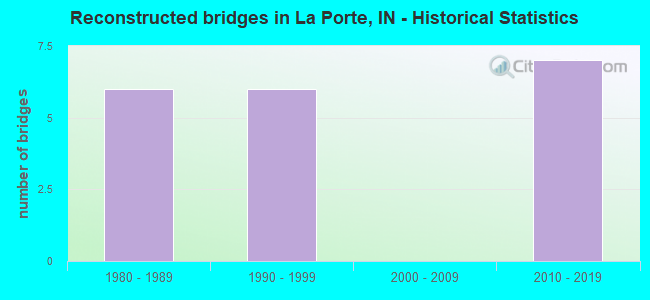
- Reconstructed bridges - Historical Statistics
- 61980-1989
- 61990-1999
- 02000-2009
- 72010-2019
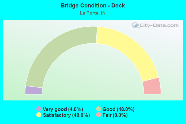
- Bridge Condition - Deck
- 4.0%Very good
- 48.0%Good
- 40.0%Satisfactory
- 8.0%Fair
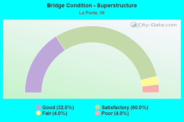
- Bridge Condition - Superstructure
- 32.0%Good
- 60.0%Satisfactory
- 4.0%Fair
- 4.0%Poor
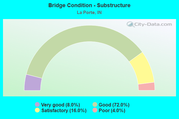
- Bridge Condition - Substructure
- 8.0%Very good
- 72.0%Good
- 16.0%Satisfactory
- 4.0%Poor
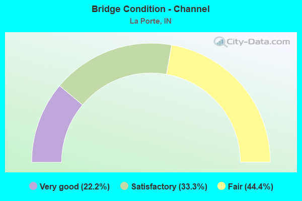
- Bridge Condition - Channel
- 22.2%Very good
- 33.3%Satisfactory
- 44.4%Fair
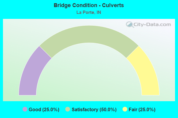
- Bridge Condition - Culverts
- 25.0%Good
- 50.0%Satisfactory
- 25.0%Fair
Find on map >> Show street view
Structure Number: 4738, Location: 03.18 E SR 39 (Lat: 41.673861, Lng: -86.680344), Route carried "under" structure: Interstate 90, Year Built: 1956, Structure Length: 0. m, Average Daily Traffic: 12,615 (year 2011), Truck Traffic: 24%, Features Intersected: I-90 WB, Facility Carried by Structure: FAIL ROAD
Minimum Vertical Clearance: 4.83m (15.85ft), Kilometerpoint: 83.815, Lanes on structure: 2, Lanes under structure: 2, Toll: On toll road, Material/Design: Steel, Design/Construction: Stringer/Multi-beam, Length of Maximum Span: 14.9m (48.9ft)
Find on map >> Show street view
Structure Number: 4738, Location: 03.18 E SR 39 (Lat: 41.673861, Lng: -86.680344), Route carried "under" structure: Interstate 90, Year Built: 1956, Structure Length: 0. m, Average Daily Traffic: 12,615 (year 2011), Truck Traffic: 24%, Features Intersected: I-90 EB, Facility Carried by Structure: FAIL ROAD
Minimum Vertical Clearance: 4.83m (15.85ft), Kilometerpoint: 83.815, Lanes on structure: 2, Lanes under structure: 2, Toll: On toll road, Material/Design: Steel, Design/Construction: Stringer/Multi-beam, Length of Maximum Span: 14.9m (48.9ft)
Find on map >> Show street view
Structure Number: 474, Location: 04.47 E SR 39 (Lat: 41.683469, Lng: -86.660994), Route carried "under" structure: Interstate 90, Year Built: 1956, Structure Length: 0. m, Average Daily Traffic: 13,580 (year 2015), Truck Traffic: 24%, Features Intersected: I-90 EB, Facility Carried by Structure: ST JOHNS ROAD
Minimum Vertical Clearance: 4.80m (15.75ft), Kilometerpoint: 85.891, Lanes on structure: 2, Lanes under structure: 2, Toll: On toll road, Material/Design: Steel continuous, Design/Construction: Stringer/Multi-beam, Length of Maximum Span: 17.4m (57.1ft)
Find on map >> Show street view
Structure Number: 474, Location: 04.47 E SR 39 (Lat: 41.683469, Lng: -86.660994), Route carried "under" structure: Interstate 90, Year Built: 1956, Structure Length: 0. m, Average Daily Traffic: 13,580 (year 2015), Truck Traffic: 24%, Features Intersected: I-90 WB, Facility Carried by Structure: ST JOHNS ROAD
Minimum Vertical Clearance: 4.80m (15.75ft), Kilometerpoint: 85.891, Lanes on structure: 2, Lanes under structure: 2, Toll: On toll road, Material/Design: Steel continuous, Design/Construction: Stringer/Multi-beam, Length of Maximum Span: 17.4m (57.1ft)
Find on map >> Show street view
Structure Number: 4741, Location: 05.68 E SR 39 (Lat: 41.693219, Lng: -86.641814), Route carried "under" structure: Interstate 90, Year Built: 1956, Structure Length: 0. m, Average Daily Traffic: 13,580 (year 2015), Truck Traffic: 24%, Features Intersected: I-90 EB, Facility Carried by Structure: BOWELL RD/CR 300E
Minimum Vertical Clearance: 4.83m (15.85ft), Kilometerpoint: 87.838, Lanes on structure: 2, Lanes under structure: 2, Toll: On toll road, Material/Design: Steel, Design/Construction: Stringer/Multi-beam, Length of Maximum Span: 22.3m (73.2ft)
Find on map >> Show street view
Structure Number: 4741, Location: 05.68 E SR 39 (Lat: 41.693219, Lng: -86.641814), Route carried "under" structure: Interstate 90, Year Built: 1956, Structure Length: 0. m, Average Daily Traffic: 13,580 (year 2015), Truck Traffic: 24%, Features Intersected: I-90 WB, Facility Carried by Structure: BOWELL RD/CR 300E
Minimum Vertical Clearance: 4.83m (15.85ft), Kilometerpoint: 87.838, Lanes on structure: 2, Lanes under structure: 2, Toll: On toll road, Material/Design: Steel, Design/Construction: Stringer/Multi-beam, Length of Maximum Span: 22.3m (73.2ft)