Bridge Statistics for Lafayette, Indiana (IN)
Condition, Traffic, Stress, Structural Evaluation, Project Costs
- National Bridge Inventory (NBI) Statistics
- 146Number of bridges
- 2,464ft / 751mTotal length
- $6,829,000Total costs
- 1,603,878Total average daily traffic
- 299,247Total average daily truck traffic
- National Bridge Inventory (NBI) Registered Bridges for Lafayette
- No street view available for this location
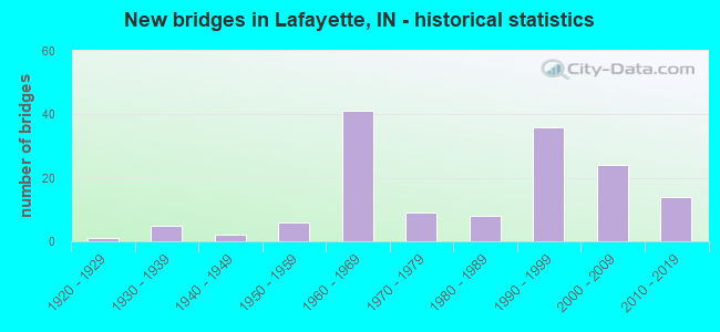
- New bridges - historical statistics
- 11920-1929
- 51930-1939
- 21940-1949
- 61950-1959
- 411960-1969
- 91970-1979
- 81980-1989
- 361990-1999
- 242000-2009
- 142010-2019
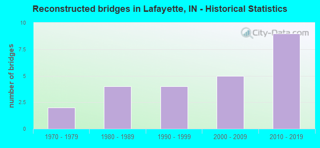
- Reconstructed bridges - Historical Statistics
- 21970-1979
- 41980-1989
- 41990-1999
- 52000-2009
- 92010-2019
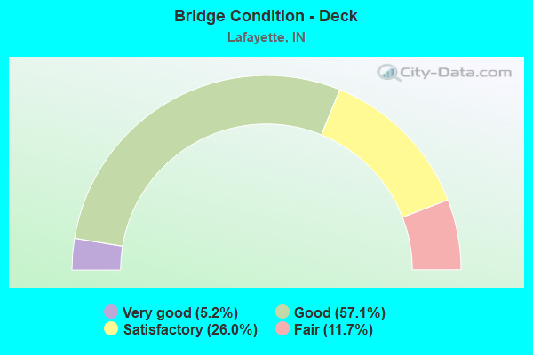
- Bridge Condition - Deck
- 5.2%Very good
- 57.1%Good
- 26.0%Satisfactory
- 11.7%Fair
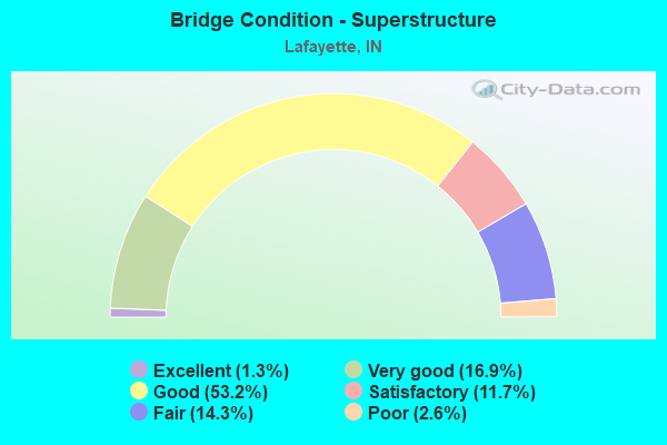
- Bridge Condition - Superstructure
- 1.3%Excellent
- 16.9%Very good
- 53.2%Good
- 11.7%Satisfactory
- 14.3%Fair
- 2.6%Poor
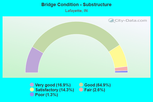
- Bridge Condition - Substructure
- 16.9%Very good
- 64.9%Good
- 14.3%Satisfactory
- 2.6%Fair
- 1.3%Poor
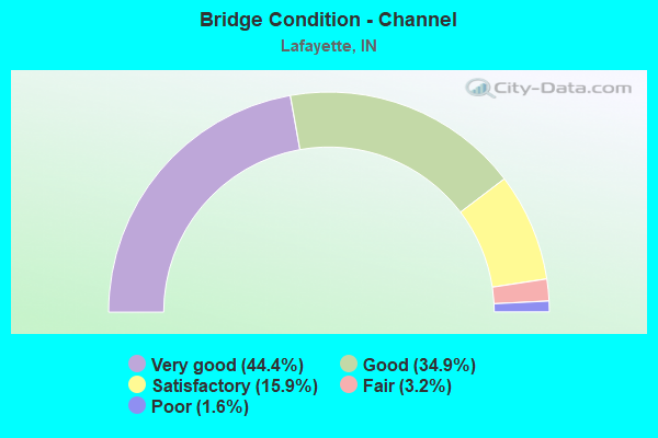
- Bridge Condition - Channel
- 44.4%Very good
- 34.9%Good
- 15.9%Satisfactory
- 3.2%Fair
- 1.6%Poor
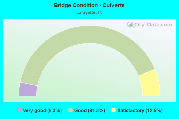
- Bridge Condition - Culverts
- 6.3%Very good
- 81.3%Good
- 12.5%Satisfactory
Find on map >> Show street view
Structure Number: 7900192, Location: 00.06 S of WeaSchool Rd (Lat: 40.345439, Lng: -86.875700), Route carried "on" structure: County highway 28, Year Built: 1967, Status: Open, Structure Length: 0.88m (2.89ft), Average Daily Traffic: 3,274 (year 2016), Truck Traffic: 7%, Average Future Daily Traffic: 4,963 (year 2038), Design Load: HS 20, Features Intersected: Tributary to Wea Creek, Facility Carried by Structure: CR 150E
Minimum Vertical Clearance: 30+ m (98+ ft), Kilometerpoint: 0.000, Lanes on structure: 2, Owner: County Highway Agency, Approaching Roadway Width: 7.3m (24.0ft), Material/Design: Steel, Design/Construction: Culvert, Number Of Spans In Main Unit: 2, Length of Maximum Span: 3.9m (12.8ft)
Condition: Channel: Very good, Culverts: Good, Structural Evaluation: Better than present minimum criteria, Waterway Adequacy: Better than present minimum criteria, Approach Roadway Alignment: Equal to present desirable criteria, Designated Inspection Frequency: Every 24 months, Inspection Date: October 2020
Find on map >> Show street view
Structure Number: 7900193, Location: 00.23 W 18TH ST (Lat: 40.381581, Lng: -86.880500), Route carried "on" structure: City street , Year Built: 2003, Status: Open, Structure Length: 9.08m (29.79ft), Average Daily Traffic: 8,144 (year 2006), Truck Traffic: 7%, Average Future Daily Traffic: 15,348 (year 2038), Design Load: HS 20, Features Intersected: N&S RR, Facility Carried by Structure: TWYKENHAM BLVD
Minimum Vertical Clearance: 30+ m (98+ ft), Kilometerpoint: 0.000, Lanes on structure: 4, Owner: County Highway Agency, Approaching Roadway Width: 14.6m (47.9ft), Skew: 5 degrees, Material/Design: Prestressed concrete continuous, Design/Construction: Tee Beam, Number Of Spans In Main Unit: 2, Length of Maximum Span: 55.3m (181.4ft), Curb or Sidewalk Widths: Left: 1.7m (5.6ft), Right: 1.7m (5.6ft), Curb-To-Curb Width: 14.6m (47.9ft), Out-to-Out Width: 18.7m (61.4ft)
Condition: Deck: Good, Superstructure: Good, Substructure: Good, Operating Rating: 64.3 metric tons, Method Used To Determine Operating Rating: Load Factor (LF), Inventory Rating: 34.9 metric tons, Method Used To Determine Inventory Rating: Load Factor (LF), Structural Evaluation: Better than present minimum criteria, Deck Geometry: High priority of replacement, Underclear: Superior to present desirable criteria, Approach Roadway Alignment: Equal to present desirable criteria, Designated Inspection Frequency: Every 24 months, Inspection Date: October 2020, Deck Structure Type: Concrete Cast-file-Place, Wearing Surface/Protective System: Wearing Surface: Monolithic Concrete, Deck Protection: Epoxy Coated Reinforcing
Find on map >> Show street view
Structure Number: 7900194, Location: 00.14 W 6TH STREET (Lat: 40.425331, Lng: -86.893200), Route carried "on" structure: City street , Year Built: 1994, Status: Open, Structure Length: 10.30m (33.79ft), Average Daily Traffic: 8,873 (year 2008), Truck Traffic: 7%, Average Future Daily Traffic: 16,073 (year 2038), Design Load: HS 20, Features Intersected: WBL OVER STREETS & RR, Facility Carried by Structure: SALEM STREET
Minimum Vertical Clearance: 30+ m (98+ ft), Kilometerpoint: 0.000, Lanes on structure: 2, Lanes under structure: 6, Owner: County Highway Agency, Approaching Roadway Width: 7.6m (24.9ft), Skew: 9 degrees, Material/Design: Steel continuous, Design/Construction: Stringer/Multi-beam, Number Of Spans In Main Unit: 5, Number Of Approach Spans: 1, Length of Maximum Span: 20.5m (67.3ft), Curb or Sidewalk Widths: Left: 0.0m, Right: 1.8m (5.9ft), Curb-To-Curb Width: 8.1m (26.6ft), Out-to-Out Width: 11.8m (38.7ft)
Condition: Deck: Satisfactory, Superstructure: Good, Substructure: Good, Operating Rating: 60.3 metric tons, Method Used To Determine Operating Rating: Load and Resistance Factor (LRFR), Inventory Rating: 60.3 metric tons, Method Used To Determine Inventory Rating: Load and Resistance Factor (LRFR), Structural Evaluation: Better than present minimum criteria, Deck Geometry: High priority of replacement, Underclear: High priority of corrective action, Approach Roadway Alignment: Equal to present desirable criteria, Designated Inspection Frequency: Every 24 months, Inspection Date: October 2020, Deck Structure Type: Concrete Cast-file-Place, Wearing Surface/Protective System: Wearing Surface: Monolithic Concrete, Deck Protection: Epoxy Coated Reinforcing
Find on map >> Show street view
Structure Number: 7900195, Location: 00.15 W 6TH STREET (Lat: 40.425119, Lng: -86.893261), Route carried "on" structure: City street , Year Built: 1994, Status: Open, Structure Length: 8.17m (26.80ft), Average Daily Traffic: 10,310 (year 2008), Truck Traffic: 7%, Average Future Daily Traffic: 18,676 (year 2038), Design Load: HS 20, Features Intersected: EB OVER STREETS, RR, Facility Carried by Structure: UNION STREET
Minimum Vertical Clearance: 30+ m (98+ ft), Kilometerpoint: 0.000, Lanes on structure: 2, Lanes under structure: 6, Owner: County Highway Agency, Approaching Roadway Width: 8.8m (28.9ft), Skew: 9 degrees, Material/Design: Steel continuous, Design/Construction: Stringer/Multi-beam, Number Of Spans In Main Unit: 4, Number Of Approach Spans: 2, Length of Maximum Span: 18.0m (59.1ft), Curb or Sidewalk Widths: Left: 0.0m, Right: 1.4m (4.6ft), Curb-To-Curb Width: 8.9m (29.2ft), Out-to-Out Width: 11.4m (37.4ft)
Condition: Deck: Good, Superstructure: Good, Substructure: Satisfactory, Operating Rating: 68.3 metric tons, Method Used To Determine Operating Rating: Load and Resistance Factor (LRFR), Inventory Rating: 68.3 metric tons, Method Used To Determine Inventory Rating: Load and Resistance Factor (LRFR), Structural Evaluation: Equal to present minimum criteria, Deck Geometry: High priority of corrective action, Underclear: High priority of corrective action, Approach Roadway Alignment: Equal to present desirable criteria, Designated Inspection Frequency: Every 24 months, Inspection Date: October 2020, Deck Structure Type: Concrete Cast-file-Place, Wearing Surface/Protective System: Wearing Surface: Monolithic Concrete, Deck Protection: Epoxy Coated Reinforcing
Find on map >> Show street view
Structure Number: 7900196, Location: 00.18 N CINCINNATI STR (Lat: 40.424900, Lng: -86.893431), Route carried "on" structure: Ramp City street , Year Built: 1994, Status: Open, Structure Length: 12.59m (41.31ft), Average Daily Traffic: 2,104 (year 2016), Truck Traffic: 7%, Average Future Daily Traffic: 3,190 (year 2038), Design Load: HS 20, Features Intersected: OVER STREETS, RR, Facility Carried by Structure: 3RD STREET RAMP
Minimum Vertical Clearance: 30+ m (98+ ft), Kilometerpoint: 0.000, Lanes on structure: 1, Lanes under structure: 4, Owner: County Highway Agency, Approaching Roadway Width: 5.8m (19.0ft), Skew: 9 degrees, Material/Design: Steel continuous, Design/Construction: Stringer/Multi-beam, Number Of Spans In Main Unit: 9, Length of Maximum Span: 17.4m (57.1ft), Curb-To-Curb Width: 8.0m (26.2ft), Out-to-Out Width: 8.9m (29.2ft)
Condition: Deck: Satisfactory, Superstructure: Good, Substructure: Good, Operating Rating: 85.1 metric tons, Method Used To Determine Operating Rating: Load and Resistance Factor (LRFR), Inventory Rating: 74.5 metric tons, Method Used To Determine Inventory Rating: Load and Resistance Factor (LRFR), Structural Evaluation: Better than present minimum criteria, Deck Geometry: Superior to present desirable criteria, Underclear: High priority of corrective action, Approach Roadway Alignment: Equal to present minimum criteria, Designated Inspection Frequency: Every 24 months, Inspection Date: October 2020, Deck Structure Type: Concrete Cast-file-Place, Wearing Surface/Protective System: Wearing Surface: Monolithic Concrete, Deck Protection: Epoxy Coated Reinforcing
Find on map >> Show street view
Structure Number: 7900197, Location: 00.33 W 6TH STREET (Lat: 40.425231, Lng: -86.896831), Route carried "on" structure: City street , Year Built: 1960, Year Reconstructed: 2004, Status: Open, Structure Length: 30.51m (100.10ft), Average Daily Traffic: 22,493 (year 2016), Truck Traffic: 7%, Average Future Daily Traffic: 34,099 (year 2038), Design Load: HS 20, Features Intersected: WABASH RIVER, Facility Carried by Structure: UNION/SALEM STREET
Minimum Vertical Clearance: 30+ m (98+ ft), Kilometerpoint: 0.000, Lanes on structure: 4, Owner: County Highway Agency, Approaching Roadway Width: 16.5m (54.1ft), Skew: 20 degrees, Material/Design: Steel continuous, Design/Construction: Stringer/Multi-beam, Number Of Spans In Main Unit: 4, Number Of Approach Spans: 6, Length of Maximum Span: 51.4m (168.6ft), Curb or Sidewalk Widths: Left: 1.7m (5.6ft), Right: 1.7m (5.6ft), Curb-To-Curb Width: 17.6m (57.7ft), Out-to-Out Width: 21.5m (70.5ft)
Condition: Deck: Good, Superstructure: Satisfactory, Substructure: Satisfactory, Channel: Very good, Operating Rating: 34.5 metric tons, Method Used To Determine Operating Rating: Load Factor (LF), Inventory Rating: 20.7 metric tons, Method Used To Determine Inventory Rating: Load Factor (LF), Structural Evaluation: Somewhat better than minimum adequacy, Deck Geometry: Somewhat better than minimum adequacy, Waterway Adequacy: Superior to present desirable criteria, Approach Roadway Alignment: Equal to present desirable criteria, Designated Inspection Frequency: Every 24 months, Critical Feature Inspection Frequency: Every 24 months, Underwater Inspection Frequency: Every 60 months, Inspection Date: October 2020, Critical Feature Inspection Date: October 2020, Underwater Inspection Date: September 2019, Deck Structure Type: Concrete Cast-file-Place, Wearing Surface/Protective System: Wearing Surface: Monolithic Concrete, Deck Protection: Epoxy Coated Reinforcing
Find on map >> Show street view
Structure Number: 7900198, Location: 00.26 S of CR 350 S (Lat: 40.364039, Lng: -86.869100), Route carried "on" structure: City street , Year Built: 2005, Status: Open, Structure Length: 0.85m (2.79ft), Average Daily Traffic: 500 (year 2018), Truck Traffic: 7%, Average Future Daily Traffic: 730 (year 2038), Design Load: HS 20, Features Intersected: KIRKPATRICK DITCH, Facility Carried by Structure: REGAL VALLEY DR
Minimum Vertical Clearance: 30+ m (98+ ft), Kilometerpoint: 0.000, Lanes on structure: 2, Owner: County Highway Agency, Approaching Roadway Width: 7.3m (24.0ft), Material/Design: Concrete, Design/Construction: Culvert, Number Of Spans In Main Unit: 1, Length of Maximum Span: 8.5m (27.9ft), Curb or Sidewalk Widths: Left: 3.3m (10.8ft), Right: 3.2m (10.5ft)
Condition: Channel: Very good, Culverts: Good, Operating Rating: 85.9 metric tons, Method Used To Determine Operating Rating: Load and Resistance Factor (LRFR), Inventory Rating: 70.9 metric tons, Method Used To Determine Inventory Rating: Load and Resistance Factor (LRFR), Structural Evaluation: Better than present minimum criteria, Waterway Adequacy: Superior to present desirable criteria, Approach Roadway Alignment: Equal to present desirable criteria, Designated Inspection Frequency: Every 24 months, Inspection Date: October 2020
Find on map >> Show street view
Structure Number: 7900199, Location: 00.21 S of US 52 (Lat: 40.359919, Lng: -86.818950), Route carried "on" structure: County highway 65, Year Built: 2007, Status: Open, Structure Length: 0.61m (2.00ft), Average Daily Traffic: 2,861 (year 2016), Truck Traffic: 7%, Average Future Daily Traffic: 4,337 (year 2038), Design Load: HS 20, Features Intersected: Kirkpatrick Ditch, Facility Carried by Structure: CR 450E
Minimum Vertical Clearance: 30+ m (98+ ft), Kilometerpoint: 0.000, Lanes on structure: 2, Owner: County Highway Agency, Approaching Roadway Width: 6.4m (21.0ft), Material/Design: Concrete, Design/Construction: Culvert, Number Of Spans In Main Unit: 1, Length of Maximum Span: 6.1m (20.0ft)
Condition: Channel: Very good, Culverts: Good, Operating Rating: 68.1 metric tons, Method Used To Determine Operating Rating: Load Factor (LF), Inventory Rating: 40.8 metric tons, Method Used To Determine Inventory Rating: Load Factor (LF), Structural Evaluation: Better than present minimum criteria, Waterway Adequacy: Superior to present desirable criteria, Approach Roadway Alignment: Equal to present desirable criteria, Designated Inspection Frequency: Every 24 months, Inspection Date: October 2020
Find on map >> Show street view
Structure Number: 7900203, Location: 00.18 N of CR 200 S (Lat: 40.391161, Lng: -86.780011), Route carried "on" structure: County highway 225, Year Built: 1989, Status: Open, Structure Length: 0.67m (2.20ft), Average Daily Traffic: 398 (year 2017), Truck Traffic: 7%, Average Future Daily Traffic: 591 (year 2038), Features Intersected: Parker Ditch, Facility Carried by Structure: CR 650E
Minimum Vertical Clearance: 30+ m (98+ ft), Kilometerpoint: 0.000, Lanes on structure: 2, Owner: County Highway Agency, Approaching Roadway Width: 6.4m (21.0ft), Skew: 3 degrees, Material/Design: Concrete, Design/Construction: Culvert, Number Of Spans In Main Unit: 2, Length of Maximum Span: 3.0m (9.8ft)
Condition: Channel: Very good, Culverts: Satisfactory, Operating Rating: 32.7 metric tons, Method Used To Determine Operating Rating: Field evaluation and documented engineering judgment, Inventory Rating: 32.7 metric tons, Method Used To Determine Inventory Rating: Field evaluation and documented engineering judgment, Structural Evaluation: Equal to present minimum criteria, Waterway Adequacy: Superior to present desirable criteria, Approach Roadway Alignment: Equal to present desirable criteria, Designated Inspection Frequency: Every 24 months, Inspection Date: September 2020
Find on map >> Show street view
Structure Number: 7900205, Location: 00.73 N of CR 700 S (Lat: 40.326550, Lng: -86.884919), Route carried "on" structure: County highway 39, Year Built: 2008, Status: Open, Structure Length: 1.22m (4.00ft), Average Daily Traffic: 2,359 (year 2016), Truck Traffic: 7%, Average Future Daily Traffic: 3,576 (year 2038), Design Load: HS 20, Features Intersected: O'Neall Drain, Facility Carried by Structure: CR 100E
Minimum Vertical Clearance: 30+ m (98+ ft), Kilometerpoint: 0.000, Lanes on structure: 2, Owner: County Highway Agency, Approaching Roadway Width: 6.4m (21.0ft), Material/Design: Prestressed concrete, Design/Construction: Box Beam or Girders - Multiple, Number Of Spans In Main Unit: 1, Length of Maximum Span: 11.6m (38.1ft), Curb-To-Curb Width: 8.6m (28.2ft), Out-to-Out Width: 9.5m (31.2ft)
Condition: Deck: Good, Superstructure: Good, Substructure: Very good, Channel: Very good, Operating Rating: 54.5 metric tons, Method Used To Determine Operating Rating: Load and Resistance Factor (LRFR), Inventory Rating: 40.5 metric tons, Method Used To Determine Inventory Rating: Load and Resistance Factor (LRFR), Structural Evaluation: Better than present minimum criteria, Deck Geometry: Meets minimum limits, Waterway Adequacy: Superior to present desirable criteria, Approach Roadway Alignment: Equal to present desirable criteria, Designated Inspection Frequency: Every 48 months, Inspection Date: October 2018, Deck Structure Type: Concrete Cast-file-Place, Wearing Surface/Protective System: Wearing Surface: Monolithic Concrete, Deck Protection: Epoxy Coated Reinforcing
Find on map >> Show street view
Structure Number: 7900209, Location: 00.72 N of Schuyler Ave (Lat: 40.463119, Lng: -86.853011), Route carried "on" structure: County highway , Year Built: 1983, Status: Open, Structure Length: 0.66m (2.17ft), Average Daily Traffic: 144 (year 2017), Truck Traffic: 7%, Average Future Daily Traffic: 214 (year 2038), Features Intersected: Dry Run, Facility Carried by Structure: Barton Beach Rd
Minimum Vertical Clearance: 30+ m (98+ ft), Kilometerpoint: 0.000, Lanes on structure: 2, Owner: County Highway Agency, Approaching Roadway Width: 4.0m (13.1ft), Material/Design: Steel, Design/Construction: Culvert, Number Of Spans In Main Unit: 3, Length of Maximum Span: 1.7m (5.6ft)
Condition: Channel: Poor, Culverts: Good, Inventory Rating: 74.7 metric tons, Method Used To Determine Inventory Rating: Load and Resistance Factor (LRFR), Structural Evaluation: Better than present minimum criteria, Waterway Adequacy: Somewhat better than minimum adequacy, Approach Roadway Alignment: High priority of corrective action, Designated Inspection Frequency: Every 24 months, Inspection Date: September 2020
Find on map >> Show street view
Structure Number: 7900216, Location: 00.93 N I-65 (Lat: 40.466819, Lng: -86.836981), Route carried "on" structure: County highway 25, Year Built: 1993, Status: Open, Structure Length: 2.94m (9.65ft), Average Daily Traffic: 6,691 (year 2017), Truck Traffic: 7%, Average Future Daily Traffic: 9,943 (year 2038), Design Load: HS 20, Features Intersected: DRY RUN
Minimum Vertical Clearance: 30+ m (98+ ft), Kilometerpoint: 0.000, Lanes on structure: 5, Owner: County Highway Agency, Approaching Roadway Width: 19.5m (64.0ft), Skew: 4 degrees, Material/Design: Prestressed concrete, Design/Construction: Stringer/Multi-beam, Number Of Spans In Main Unit: 1, Length of Maximum Span: 27.0m (88.6ft), Curb or Sidewalk Widths: Left: 1.8m (5.9ft), Right: 1.8m (5.9ft), Curb-To-Curb Width: 20.3m (66.6ft), Out-to-Out Width: 24.9m (81.7ft)
Condition: Deck: Good, Superstructure: Good, Substructure: Good, Channel: Very good, Operating Rating: 54.1 metric tons, Method Used To Determine Operating Rating: Load and Resistance Factor (LRFR), Inventory Rating: 39.0 metric tons, Method Used To Determine Inventory Rating: Load and Resistance Factor (LRFR), Structural Evaluation: Better than present minimum criteria, Deck Geometry: Somewhat better than minimum adequacy, Waterway Adequacy: Superior to present desirable criteria, Approach Roadway Alignment: Equal to present desirable criteria, Designated Inspection Frequency: Every 24 months, Inspection Date: September 2020, Deck Structure Type: Concrete Cast-file-Place, Wearing Surface/Protective System: Wearing Surface: Monolithic Concrete, Deck Protection: Epoxy Coated Reinforcing
Find on map >> Show street view
Structure Number: 7900223, Location: 00.02 S of CR 550 S (Lat: 40.337911, Lng: -86.809400), Route carried "on" structure: County highway 163, Year Built: 2014, Status: Open, Structure Length: 0.61m (2.00ft), Average Daily Traffic: 49 (year 2018), Truck Traffic: 7%, Average Future Daily Traffic: 71 (year 2038), Design Load: HL 93, Features Intersected: DISMAL CREEK, Facility Carried by Structure: CR 500E
Minimum Vertical Clearance: 30+ m (98+ ft), Kilometerpoint: 0.000, Lanes on structure: 2, Owner: County Highway Agency, Approaching Roadway Width: 6.1m (20.0ft), Material/Design: Concrete, Design/Construction: Culvert, Number Of Spans In Main Unit: 1, Length of Maximum Span: 6.1m (20.0ft)
Condition: Channel: Very good, Culverts: Good, Operating Rating: 56.0 metric tons, Method Used To Determine Operating Rating: Load and Resistance Factor (LRFR), Inventory Rating: 53.4 metric tons, Method Used To Determine Inventory Rating: Load and Resistance Factor (LRFR), Structural Evaluation: Better than present minimum criteria, Waterway Adequacy: Better than present minimum criteria, Approach Roadway Alignment: Equal to present desirable criteria, Designated Inspection Frequency: Every 24 months, Inspection Date: October 2020
Find on map >> Show street view
Structure Number: 7900224, Location: 00.58 E of CR 550 E (Lat: 40.432350, Lng: -86.788531), Route carried "on" structure: County highway 44, Year Built: 2014, Status: Open, Structure Length: 9.84m (32.28ft), Average Daily Traffic: 2,394 (year 2018), Truck Traffic: 7%, Average Future Daily Traffic: 3,488 (year 2038), Design Load: HS 20, Features Intersected: S FORK WILDCAT CREEK, Facility Carried by Structure: CR 100N
Minimum Vertical Clearance: 30+ m (98+ ft), Kilometerpoint: 0.000, Lanes on structure: 2, Owner: County Highway Agency, Approaching Roadway Width: 8.8m (28.9ft), Skew: 2 degrees, Material/Design: Prestressed concrete continuous, Design/Construction: Tee Beam, Number Of Spans In Main Unit: 3, Length of Maximum Span: 48.8m (160.1ft), Curb-To-Curb Width: 9.4m (30.8ft), Out-to-Out Width: 10.1m (33.1ft)
Condition: Deck: Good, Superstructure: Very good, Substructure: Very good, Channel: Very good, Operating Rating: 65.8 metric tons, Method Used To Determine Operating Rating: Load and Resistance Factor (LRFR), Inventory Rating: 60.6 metric tons, Method Used To Determine Inventory Rating: Load and Resistance Factor (LRFR), Structural Evaluation: Equal to present desirable criteria, Waterway Adequacy: Equal to present desirable criteria, Approach Roadway Alignment: Equal to present desirable criteria, Designated Inspection Frequency: Every 48 months, Inspection Date: September 2018, Deck Structure Type: Concrete Cast-file-Place, Wearing Surface/Protective System: Wearing Surface: Monolithic Concrete, Deck Protection: Epoxy Coated Reinforcing
Find on map >> Show street view
Structure Number: 7900225, Location: 01.20 W US 52 (Lat: 40.338000, Lng: -86.813250), Route carried "on" structure: County highway 30, Year Built: 2013, Status: Open, Structure Length: 0.95m (3.12ft), Average Daily Traffic: 152 (year 2018), Truck Traffic: 7%, Average Future Daily Traffic: 221 (year 2038), Design Load: HL 93, Features Intersected: DISMAL CREEK, Facility Carried by Structure: CR 550S
Minimum Vertical Clearance: 30+ m (98+ ft), Kilometerpoint: 0.000, Lanes on structure: 2, Owner: County Highway Agency, Approaching Roadway Width: 6.1m (20.0ft), Skew: 5 degrees, Material/Design: Concrete, Design/Construction: Culvert, Number Of Spans In Main Unit: 1, Length of Maximum Span: 9.5m (31.2ft)
Condition: Channel: Very good, Culverts: Good, Operating Rating: 32.7 metric tons, Method Used To Determine Operating Rating: Field evaluation and documented engineering judgment, Inventory Rating: 32.7 metric tons, Method Used To Determine Inventory Rating: Field evaluation and documented engineering judgment, Structural Evaluation: Better than present minimum criteria, Waterway Adequacy: Superior to present desirable criteria, Approach Roadway Alignment: Equal to present desirable criteria, Designated Inspection Frequency: Every 24 months, Inspection Date: October 2020
Find on map >> Show street view
Structure Number: 7900232, Location: 0.64 E of Old SR 25 (Lat: 40.462781, Lng: -86.829789), Route carried "on" structure: County highway , Year Built: 2012, Status: Open, Structure Length: 0.73m (2.40ft), Average Daily Traffic: 2,222 (year 2017), Truck Traffic: 7%, Average Future Daily Traffic: 3,302 (year 2038), Features Intersected: UNNAMED WATERWAY, Facility Carried by Structure: CR 300N
Minimum Vertical Clearance: 30+ m (98+ ft), Kilometerpoint: 0.000, Lanes on structure: 2, Owner: County Highway Agency, Approaching Roadway Width: 12.8m (42.0ft), Skew: 5 degrees, Material/Design: Concrete, Design/Construction: Culvert, Number Of Spans In Main Unit: 1, Length of Maximum Span: 7.3m (24.0ft)
Condition: Channel: Very good, Culverts: Very good, Operating Rating: 32.7 metric tons, Method Used To Determine Operating Rating: Field evaluation and documented engineering judgment, Inventory Rating: 32.7 metric tons, Method Used To Determine Inventory Rating: Field evaluation and documented engineering judgment, Structural Evaluation: Equal to present desirable criteria, Waterway Adequacy: Superior to present desirable criteria, Approach Roadway Alignment: Equal to present desirable criteria, Designated Inspection Frequency: Every 24 months, Inspection Date: September 2020
Find on map >> Show street view
Structure Number: 636, Location: 00.83 S US 231 (Lat: 40.381650, Lng: -86.933022), Route carried "under" structure: State highway 25, Year Built: 1934, Structure Length: 0. m, Average Daily Traffic: 10,845 (year 2004), Truck Traffic: 5%, Features Intersected: SR 25, Facility Carried by Structure: CSX RR
Minimum Vertical Clearance: 4.29m (14.07ft), Kilometerpoint: 26.619, Lanes under structure: 2, Material/Design: Steel, Design/Construction: Stringer/Multi-beam, Length of Maximum Span: 12.2m (40.0ft)
Find on map >> Show street view
Structure Number: 1901, Location: 00.46 E SR 443 (Lat: 40.451531, Lng: -86.894172), Route carried "under" structure: City street , Year Built: 2018, Structure Length: 0. m, Average Daily Traffic: 5,310 (year 2018), Truck Traffic: 20%, Features Intersected: N River RD, Facility Carried by Structure: 52X-SAGAMORE PKWY
Minimum Vertical Clearance: 12.44m (40.81ft), Kilometerpoint: 2.977, Lanes on structure: 2, Lanes under structure: 2, Material/Design: Prestressed concrete continuous, Design/Construction: Stringer/Multi-beam, Length of Maximum Span: 46.3m (151.9ft)
Find on map >> Show street view
Structure Number: 19025, Location: 01.37 E SR 443 (Lat: 40.448639, Lng: -86.877258), Route carried "under" structure: City street , Year Built: 1971, Structure Length: 0. m, Average Daily Traffic: 5,940 (year 2009), Truck Traffic: 10%, Features Intersected: 9TH ST & RAMP, Facility Carried by Structure: EB SAGAMORE PKWY
Minimum Vertical Clearance: 4.50m (14.76ft), Kilometerpoint: 0.000, Lanes on structure: 2, Lanes under structure: 4, Material/Design: Steel continuous, Design/Construction: Stringer/Multi-beam, Length of Maximum Span: 32.9m (107.9ft)
Find on map >> Show street view
Structure Number: 19025, Location: 01.37 E SR 443 (Lat: 40.448639, Lng: -86.877258), Route carried "under" structure: Ramp City street , Year Built: 1971, Structure Length: 0. m, Average Daily Traffic: 50 (year 2010), Truck Traffic: 10%, Features Intersected: 9TH ST & RAMP, Facility Carried by Structure: EB SAGAMORE PKWY
Minimum Vertical Clearance: 7.44m (24.41ft), Kilometerpoint: 0.000, Lanes on structure: 2, Lanes under structure: 4, Material/Design: Steel continuous, Design/Construction: Stringer/Multi-beam, Length of Maximum Span: 32.9m (107.9ft)
Find on map >> Show street view
Structure Number: 19027, Location: 01.37 E SR 443 (Lat: 40.448839, Lng: -86.877150), Route carried "under" structure: City street , Year Built: 1971, Structure Length: 0. m, Average Daily Traffic: 5,940 (year 2009), Truck Traffic: 10%, Features Intersected: 9TH ST & RAMP, Facility Carried by Structure: WB SAGAMORE PKWY
Minimum Vertical Clearance: 4.32m (14.17ft), Kilometerpoint: 0.000, Lanes on structure: 2, Lanes under structure: 2, Material/Design: Steel continuous, Design/Construction: Stringer/Multi-beam, Length of Maximum Span: 30.8m (101.0ft)
Find on map >> Show street view
Structure Number: 19027, Location: 01.37 E SR 443 (Lat: 40.448839, Lng: -86.877150), Route carried "under" structure: Ramp City street , Year Built: 1971, Structure Length: 0. m, Average Daily Traffic: 50 (year 2010), Truck Traffic: 10%, Features Intersected: 9TH ST & RAMP, Facility Carried by Structure: WB SAGAMORE PKWY
Minimum Vertical Clearance: 7.72m (25.33ft), Kilometerpoint: 0.000, Lanes on structure: 2, Lanes under structure: 2, Material/Design: Steel continuous, Design/Construction: Stringer/Multi-beam, Length of Maximum Span: 30.8m (101.0ft)
Find on map >> Show street view
Structure Number: 19028, Location: 01.66 E SR 443 (Lat: 40.446639, Lng: -86.872947), Route carried "under" structure: City street , Year Built: 1998, Structure Length: 0. m, Average Daily Traffic: 14,720 (year 2006), Truck Traffic: 4%, Features Intersected: US 52 EB, Facility Carried by Structure: N&S RR
Minimum Vertical Clearance: 5.13m (16.83ft), Kilometerpoint: 20.133, Lanes under structure: 2, Material/Design: Steel, Design/Construction: Girder and Floorbeam System, Length of Maximum Span: 29.7m (97.4ft)
Find on map >> Show street view
Structure Number: 19028, Location: 01.66 E SR 443 (Lat: 40.446639, Lng: -86.872947), Route carried "under" structure: City street , Year Built: 1998, Structure Length: 0. m, Average Daily Traffic: 14,720 (year 2006), Truck Traffic: 4%, Features Intersected: US 52 WB, Facility Carried by Structure: N&S RR
Minimum Vertical Clearance: 5.13m (16.83ft), Kilometerpoint: 20.133, Lanes under structure: 2, Material/Design: Steel, Design/Construction: Girder and Floorbeam System, Length of Maximum Span: 29.7m (97.4ft)
Find on map >> Show street view
Structure Number: 3752, Location: 03.71 S SR 38 (Lat: 40.325861, Lng: -86.752914), Route carried "under" structure: Interstate 65, Year Built: 1968, Structure Length: 0. m, Average Daily Traffic: 20,108 (year 2014), Truck Traffic: 10%, Features Intersected: I-65 SB, Facility Carried by Structure: CR 800 E
Minimum Vertical Clearance: 4.88m (16.01ft), Kilometerpoint: 264.657, Lanes on structure: 2, Lanes under structure: 2, Material/Design: Steel continuous, Design/Construction: Stringer/Multi-beam, Length of Maximum Span: 37.3m (122.4ft)
Find on map >> Show street view
Structure Number: 3752, Location: 03.71 S SR 38 (Lat: 40.325861, Lng: -86.752914), Route carried "under" structure: Interstate 65, Year Built: 1968, Structure Length: 0. m, Average Daily Traffic: 20,108 (year 2014), Truck Traffic: 10%, Features Intersected: I-65 NB, Facility Carried by Structure: CR 800E
Minimum Vertical Clearance: 4.88m (16.01ft), Kilometerpoint: 264.657, Lanes on structure: 2, Lanes under structure: 2, Material/Design: Steel continuous, Design/Construction: Stringer/Multi-beam, Length of Maximum Span: 37.3m (122.4ft)
Find on map >> Show street view
Structure Number: 3754, Location: 00.77 S SR 38 (Lat: 40.363700, Lng: -86.778825), Route carried "under" structure: Interstate 65, Year Built: 1968, Structure Length: 0. m, Average Daily Traffic: 20,108 (year 2014), Truck Traffic: 46%, Features Intersected: I-65 NB, Facility Carried by Structure: CR 375S
Minimum Vertical Clearance: 4.93m (16.17ft), Kilometerpoint: 269.388, Lanes on structure: 2, Lanes under structure: 2, Material/Design: Steel continuous, Design/Construction: Stringer/Multi-beam, Length of Maximum Span: 38.1m (125.0ft)
Find on map >> Show street view
Structure Number: 3754, Location: 00.77 S SR 38 (Lat: 40.363700, Lng: -86.778825), Route carried "under" structure: Interstate 65, Year Built: 1968, Structure Length: 0. m, Average Daily Traffic: 20,108 (year 2014), Truck Traffic: 46%, Features Intersected: I-65 SB, Facility Carried by Structure: CR 375 S
Minimum Vertical Clearance: 4.93m (16.17ft), Kilometerpoint: 269.388, Lanes on structure: 2, Lanes under structure: 2, Material/Design: Steel continuous, Design/Construction: Stringer/Multi-beam, Length of Maximum Span: 38.1m (125.0ft)
Find on map >> Show street view
Structure Number: 3759, Location: 01.05 N SR 38 (Lat: 40.388519, Lng: -86.790283), Route carried "under" structure: Interstate 65, Year Built: 1968, Structure Length: 0. m, Average Daily Traffic: 21,435 (year 2006), Truck Traffic: 40%, Features Intersected: I-65 NB, Facility Carried by Structure: CR 200 S
Minimum Vertical Clearance: 4.88m (16.01ft), Kilometerpoint: 272.317, Lanes on structure: 2, Lanes under structure: 2, Material/Design: Steel continuous, Design/Construction: Stringer/Multi-beam, Length of Maximum Span: 36.7m (120.4ft)
Find on map >> Show street view
Structure Number: 3759, Location: 01.05 N SR 38 (Lat: 40.388519, Lng: -86.790283), Route carried "under" structure: Interstate 65, Year Built: 1968, Structure Length: 0. m, Average Daily Traffic: 21,435 (year 2006), Truck Traffic: 40%, Features Intersected: I-65 SB, Facility Carried by Structure: CR 200 S
Minimum Vertical Clearance: 4.88m (16.01ft), Kilometerpoint: 272.317, Lanes on structure: 2, Lanes under structure: 2, Material/Design: Steel continuous, Design/Construction: Stringer/Multi-beam, Length of Maximum Span: 36.7m (120.4ft)
Find on map >> Show street view
Structure Number: 37594, Location: 01.32 S SR 26 (Lat: 40.403061, Lng: -86.802344), Route carried "under" structure: Interstate 65, Year Built: 2002, Structure Length: 0. m, Average Daily Traffic: 21,435 (year 2006), Truck Traffic: 40%, Features Intersected: I-65 SBL, Facility Carried by Structure: CR 100S/MCCARTY LN
Minimum Vertical Clearance: 5.41m (17.75ft), Kilometerpoint: 274.248, Lanes on structure: 4, Lanes under structure: 4, Material/Design: Prestressed concrete continuous, Design/Construction: Tee Beam, Length of Maximum Span: 38.4m (126.0ft)
Find on map >> Show street view
Structure Number: 37594, Location: 01.32 S SR 26 (Lat: 40.403061, Lng: -86.802344), Route carried "under" structure: Interstate 65, Year Built: 2002, Structure Length: 0. m, Average Daily Traffic: 21,435 (year 2006), Truck Traffic: 40%, Features Intersected: I-65 NBL, Facility Carried by Structure: CR 100S/MCCARTY LN
Minimum Vertical Clearance: 5.08m (16.67ft), Kilometerpoint: 274.248, Lanes on structure: 4, Lanes under structure: 4, Material/Design: Prestressed concrete continuous, Design/Construction: Tee Beam, Length of Maximum Span: 38.4m (126.0ft)
Find on map >> Show street view
Structure Number: 376, Location: 00.81 S SR 26 (Lat: 40.408019, Lng: -86.809875), Route carried "under" structure: Interstate 65, Year Built: 1968, Structure Length: 0. m, Average Daily Traffic: 21,435 (year 2006), Truck Traffic: 40%, Features Intersected: I-65 NB, Facility Carried by Structure: CR 500 E
Minimum Vertical Clearance: 4.90m (16.08ft), Kilometerpoint: 275.069, Lanes on structure: 2, Lanes under structure: 2, Material/Design: Steel continuous, Design/Construction: Stringer/Multi-beam, Length of Maximum Span: 40.8m (133.9ft)
Find on map >> Show street view
Structure Number: 376, Location: 00.81 S SR 26 (Lat: 40.408019, Lng: -86.809875), Route carried "under" structure: Interstate 65, Year Built: 1968, Structure Length: 0. m, Average Daily Traffic: 21,435 (year 2006), Truck Traffic: 40%, Features Intersected: I-65 SB, Facility Carried by Structure: CR 500 E
Minimum Vertical Clearance: 4.93m (16.17ft), Kilometerpoint: 275.069, Lanes on structure: 2, Lanes under structure: 2, Material/Design: Steel continuous, Design/Construction: Stringer/Multi-beam, Length of Maximum Span: 40.8m (133.9ft)
Find on map >> Show street view
Structure Number: 3761, Location: 03.04 S SR 25 (Lat: 40.417589, Lng: -86.820603), Route carried "under" structure: State highway 26, Year Built: 1968, Structure Length: 0. m, Average Daily Traffic: 18,035 (year 2006), Truck Traffic: 2%, Features Intersected: SR 26 EBL, Facility Carried by Structure: I-65 NB
Minimum Vertical Clearance: 4.93m (16.17ft), Kilometerpoint: 24.430, Lanes on structure: 2, Lanes under structure: 4, Material/Design: Steel continuous, Design/Construction: Stringer/Multi-beam, Length of Maximum Span: 29.1m (95.5ft)
Find on map >> Show street view
Structure Number: 3761, Location: 03.04 S SR 25 (Lat: 40.417589, Lng: -86.820603), Route carried "under" structure: State highway 26, Year Built: 1968, Structure Length: 0. m, Average Daily Traffic: 18,035 (year 2006), Truck Traffic: 2%, Features Intersected: SR 26 WBL, Facility Carried by Structure: I-65 NB
Minimum Vertical Clearance: 4.93m (16.17ft), Kilometerpoint: 24.430, Lanes on structure: 2, Lanes under structure: 4, Material/Design: Steel continuous, Design/Construction: Stringer/Multi-beam, Length of Maximum Span: 29.1m (95.5ft)
Find on map >> Show street view
Structure Number: 3762, Location: 03.04 S SR 25 (Lat: 40.417589, Lng: -86.820992), Route carried "under" structure: State highway 26, Year Built: 1968, Structure Length: 0. m, Average Daily Traffic: 16,780 (year 2015), Truck Traffic: 5%, Features Intersected: SR 26 EBL, Facility Carried by Structure: I-65 SB
Minimum Vertical Clearance: 4.83m (15.85ft), Kilometerpoint: 24.414, Lanes on structure: 3, Lanes under structure: 6, Material/Design: Steel continuous, Design/Construction: Stringer/Multi-beam, Length of Maximum Span: 29.1m (95.5ft)
Find on map >> Show street view
Structure Number: 3762, Location: 03.04 S SR 25 (Lat: 40.417589, Lng: -86.820992), Route carried "under" structure: Interstate 26, Year Built: 1968, Structure Length: 0. m, Average Daily Traffic: 16,780 (year 2015), Truck Traffic: 5%, Features Intersected: SR 26 WBL, Facility Carried by Structure: I-65 SB
Minimum Vertical Clearance: 4.78m (15.68ft), Kilometerpoint: 24.414, Lanes on structure: 3, Lanes under structure: 6, Material/Design: Steel continuous, Design/Construction: Stringer/Multi-beam, Length of Maximum Span: 29.1m (95.5ft)
Find on map >> Show street view
Structure Number: 3763, Location: 01.41 S SR 25 (Lat: 40.437781, Lng: -86.836089), Route carried "under" structure: Interstate 65, Year Built: 1969, Structure Length: 0. m, Average Daily Traffic: 17,470 (year 2010), Truck Traffic: 37%, Features Intersected: I-65 SBL, Facility Carried by Structure: CR 350E/EISENHOWER
Minimum Vertical Clearance: 5.94m (19.49ft), Kilometerpoint: 278.996, Lanes on structure: 2, Lanes under structure: 4, Material/Design: Steel continuous, Design/Construction: Stringer/Multi-beam, Length of Maximum Span: 29.5m (96.8ft)
Find on map >> Show street view
Structure Number: 3763, Location: 01.41 S SR 25 (Lat: 40.437781, Lng: -86.836089), Route carried "under" structure: Interstate 65, Year Built: 1969, Structure Length: 0. m, Average Daily Traffic: 17,470 (year 2010), Truck Traffic: 37%, Features Intersected: I-65 NBL, Facility Carried by Structure: CR 350E/EISENHOWER
Minimum Vertical Clearance: 4.95m (16.24ft), Kilometerpoint: 278.996, Lanes on structure: 2, Lanes under structure: 4, Material/Design: Steel continuous, Design/Construction: Stringer/Multi-beam, Length of Maximum Span: 29.5m (96.8ft)
Find on map >> Show street view
Structure Number: 3766, Location: 00.64 S SR 25 (Lat: 40.446839, Lng: -86.844558), Route carried "under" structure: Interstate 65, Year Built: 1969, Structure Length: 0. m, Average Daily Traffic: 17,470 (year 2011), Truck Traffic: 36%, Features Intersected: I-65 SBL, Facility Carried by Structure: CR 200 N
Minimum Vertical Clearance: 5.16m (16.93ft), Kilometerpoint: 280.235, Lanes on structure: 2, Lanes under structure: 4, Material/Design: Steel continuous, Design/Construction: Stringer/Multi-beam, Length of Maximum Span: 37.6m (123.4ft)
Find on map >> Show street view
Structure Number: 3766, Location: 00.64 S SR 25 (Lat: 40.446839, Lng: -86.844558), Route carried "under" structure: Interstate 65, Year Built: 1969, Structure Length: 0. m, Average Daily Traffic: 17,470 (year 2011), Truck Traffic: 36%, Features Intersected: I-65 NBL, Facility Carried by Structure: CR 200N
Minimum Vertical Clearance: 6.22m (20.41ft), Kilometerpoint: 280.235, Lanes on structure: 2, Lanes under structure: 4, Material/Design: Steel continuous, Design/Construction: Stringer/Multi-beam, Length of Maximum Span: 37.6m (123.4ft)
Find on map >> Show street view
Structure Number: 3767, Location: 00.28 S SR 25 (Lat: 40.451931, Lng: -86.846253), Route carried "under" structure: Interstate 65, Year Built: 1969, Structure Length: 0. m, Average Daily Traffic: 23,970 (year 2006), Truck Traffic: 36%, Features Intersected: I-65 SBL, Facility Carried by Structure: N&S RR
Minimum Vertical Clearance: 4.90m (16.08ft), Kilometerpoint: 280.814, Lanes under structure: 6, Material/Design: Steel, Design/Construction: Stringer/Multi-beam, Length of Maximum Span: 26.7m (87.6ft)
Find on map >> Show street view
Structure Number: 3767, Location: 00.28 S SR 25 (Lat: 40.451931, Lng: -86.846253), Route carried "under" structure: Interstate 65, Year Built: 1969, Structure Length: 0. m, Average Daily Traffic: 23,970 (year 2006), Truck Traffic: 36%, Features Intersected: I-65 NBL, Facility Carried by Structure: N&S RR
Minimum Vertical Clearance: 5.01m (16.44ft), Kilometerpoint: 280.814, Lanes under structure: 6, Material/Design: Steel, Design/Construction: Stringer/Multi-beam, Length of Maximum Span: 26.7m (87.6ft)
Find on map >> Show street view
Structure Number: 3768, Location: 03.04 N SR 26 (Lat: 40.456000, Lng: -86.847419), Route carried "under" structure: State highway 25, Year Built: 1969, Structure Length: 0. m, Average Daily Traffic: 8,310 (year 2010), Truck Traffic: 10%, Features Intersected: SR 25 EBL, Facility Carried by Structure: I-65 NB
Minimum Vertical Clearance: 5.18m (16.99ft), Kilometerpoint: 51.982, Lanes on structure: 2, Lanes under structure: 4, Material/Design: Steel continuous, Design/Construction: Stringer/Multi-beam, Length of Maximum Span: 23.2m (76.1ft)
Find on map >> Show street view
Structure Number: 3768, Location: 03.04 N SR 26 (Lat: 40.456000, Lng: -86.847419), Route carried "under" structure: State highway 25, Year Built: 1969, Structure Length: 0. m, Average Daily Traffic: 8,310 (year 2010), Truck Traffic: 10%, Features Intersected: SR 25 WBL, Facility Carried by Structure: I-65 NB
Minimum Vertical Clearance: 5.18m (16.99ft), Kilometerpoint: 51.982, Lanes on structure: 2, Lanes under structure: 4, Material/Design: Steel continuous, Design/Construction: Stringer/Multi-beam, Length of Maximum Span: 23.2m (76.1ft)
Find on map >> Show street view
Structure Number: 3769, Location: 03.04 N SR 26 (Lat: 40.455819, Lng: -86.847694), Route carried "under" structure: State highway 25, Year Built: 1969, Structure Length: 0. m, Average Daily Traffic: 8,310 (year 2010), Truck Traffic: 10%, Features Intersected: SR 25 EBL, Facility Carried by Structure: I-65 SB
Minimum Vertical Clearance: 5.11m (16.77ft), Kilometerpoint: 51.998, Lanes on structure: 2, Lanes under structure: 4, Material/Design: Steel continuous, Design/Construction: Stringer/Multi-beam, Length of Maximum Span: 23.2m (76.1ft)
Find on map >> Show street view
Structure Number: 3769, Location: 03.04 N SR 26 (Lat: 40.455819, Lng: -86.847694), Route carried "under" structure: State highway 25, Year Built: 1969, Structure Length: 0. m, Average Daily Traffic: 8,310 (year 2010), Truck Traffic: 10%, Features Intersected: SR 25 WBL, Facility Carried by Structure: I-65 SB
Minimum Vertical Clearance: 5.11m (16.77ft), Kilometerpoint: 51.998, Lanes on structure: 2, Lanes under structure: 4, Material/Design: Steel continuous, Design/Construction: Stringer/Multi-beam, Length of Maximum Span: 23.2m (76.1ft)
Find on map >> Show street view
Structure Number: 76435, Location: 00.54 N SR 25 (Lat: 40.394711, Lng: -86.921211), Route carried "under" structure: US 231, Year Built: 1996, Structure Length: 0. m, Average Daily Traffic: 9,265 (year 2010), Truck Traffic: 10%, Features Intersected: US 231 SBL, Facility Carried by Structure: NS RR
Minimum Vertical Clearance: 8.79m (28.84ft), Kilometerpoint: 20.358, Lanes under structure: 4, Material/Design: Steel, Design/Construction: Stringer/Multi-beam, Length of Maximum Span: 22.6m (74.1ft)
Find on map >> Show street view
Structure Number: 76435, Location: 00.54 N SR 25 (Lat: 40.394711, Lng: -86.921211), Route carried "under" structure: US 231, Year Built: 1996, Structure Length: 0. m, Average Daily Traffic: 9,265 (year 2010), Truck Traffic: 10%, Features Intersected: US 231 NBL, Facility Carried by Structure: NS RR
Minimum Vertical Clearance: 9.07m (29.76ft), Kilometerpoint: 20.358, Lanes under structure: 4, Material/Design: Steel, Design/Construction: Stringer/Multi-beam, Length of Maximum Span: 22.6m (74.1ft)
Find on map >> Show street view
Structure Number: 76436, Location: 00.63 N SR 25 (Lat: 40.395961, Lng: -86.921111), Route carried "under" structure: US 231, Year Built: 1997, Structure Length: 0. m, Average Daily Traffic: 9,265 (year 2010), Truck Traffic: 9%, Features Intersected: US 231 NBL, Facility Carried by Structure: CSX RR
Minimum Vertical Clearance: 5.31m (17.42ft), Kilometerpoint: 20.503, Lanes under structure: 4, Material/Design: Steel, Design/Construction: Girder and Floorbeam System, Length of Maximum Span: 22.7m (74.5ft)
Find on map >> Show street view
Structure Number: 76436, Location: 00.63 N SR 25 (Lat: 40.395961, Lng: -86.921111), Route carried "under" structure: US 231, Year Built: 1997, Structure Length: 0. m, Average Daily Traffic: 9,265 (year 2010), Truck Traffic: 9%, Features Intersected: US 231 SBL, Facility Carried by Structure: CSX RR
Minimum Vertical Clearance: 5.87m (19.26ft), Kilometerpoint: 20.503, Lanes under structure: 4, Material/Design: Steel, Design/Construction: Girder and Floorbeam System, Length of Maximum Span: 22.7m (74.5ft)
Find on map >> Show street view
Structure Number: 76438, Location: 00.23 N SR 25 (Lat: 40.390300, Lng: -86.920311), Route carried "under" structure: US 231, Year Built: 2000, Structure Length: 0. m, Average Daily Traffic: 39,972 (year 2004), Truck Traffic: 10%, Features Intersected: US 231 NB, Facility Carried by Structure: ELSTON ROAD
Minimum Vertical Clearance: 5.05m (16.57ft), Kilometerpoint: 19.859, Lanes on structure: 2, Lanes under structure: 4, Material/Design: Prestressed concrete continuous, Design/Construction: Stringer/Multi-beam, Length of Maximum Span: 31.1m (102.0ft)
Find on map >> Show street view
Structure Number: 76438, Location: 00.23 N SR 25 (Lat: 40.390300, Lng: -86.920311), Route carried "under" structure: US 231, Year Built: 2000, Structure Length: 0. m, Average Daily Traffic: 39,972 (year 2004), Truck Traffic: 10%, Features Intersected: US 231 SB, Facility Carried by Structure: ELSTON ROAD
Minimum Vertical Clearance: 5.05m (16.57ft), Kilometerpoint: 19.859, Lanes on structure: 2, Lanes under structure: 4, Material/Design: Prestressed concrete continuous, Design/Construction: Stringer/Multi-beam, Length of Maximum Span: 31.1m (102.0ft)
Find on map >> Show street view
Structure Number: 7674, Location: 02.10 N I-65 (Lat: 40.467069, Lng: -86.810958), Route carried "under" structure: State highway 25, Year Built: 2009, Structure Length: 0. m, Average Daily Traffic: 7,650 (year 2006), Truck Traffic: 17%, Features Intersected: SR 25 NB, Facility Carried by Structure: CR 500 E
Minimum Vertical Clearance: 7.32m (24.02ft), Kilometerpoint: 60.640, Lanes on structure: 2, Lanes under structure: 4, Material/Design: Prestressed concrete continuous, Design/Construction: Tee Beam, Length of Maximum Span: 35.4m (116.1ft)
Find on map >> Show street view
Structure Number: 7674, Location: 02.10 N I-65 (Lat: 40.467069, Lng: -86.810958), Route carried "under" structure: State highway 25, Year Built: 2009, Structure Length: 0. m, Average Daily Traffic: 7,650 (year 2006), Truck Traffic: 17%, Features Intersected: SR 25 SB, Facility Carried by Structure: CR 500 E
Minimum Vertical Clearance: 7.32m (24.02ft), Kilometerpoint: 60.640, Lanes on structure: 2, Lanes under structure: 4, Material/Design: Prestressed concrete continuous, Design/Construction: Tee Beam, Length of Maximum Span: 35.4m (116.1ft)
Find on map >> Show street view
Structure Number: 76822, Location: 01.30 N I-65 (Lat: 40.461400, Lng: -86.824936), Route carried "under" structure: State highway 25, Year Built: 2010, Structure Length: 0. m, Average Daily Traffic: 4,750 (year 2010), Truck Traffic: 17%, Features Intersected: SR 25 SBL, Facility Carried by Structure: CR 300 N
Minimum Vertical Clearance: 7.24m (23.75ft), Kilometerpoint: 57.309, Lanes on structure: 2, Lanes under structure: 4, Material/Design: Prestressed concrete continuous, Design/Construction: Tee Beam, Length of Maximum Span: 34.7m (113.8ft)
Find on map >> Show street view
Structure Number: 76822, Location: 01.30 N I-65 (Lat: 40.461400, Lng: -86.824936), Route carried "under" structure: State highway 25, Year Built: 2010, Structure Length: 0. m, Average Daily Traffic: 4,750 (year 2010), Truck Traffic: 17%, Features Intersected: SR 25 NBL, Facility Carried by Structure: CR 300N
Minimum Vertical Clearance: 7.24m (23.75ft), Kilometerpoint: 57.309, Lanes on structure: 2, Lanes under structure: 4, Material/Design: Prestressed concrete continuous, Design/Construction: Tee Beam, Length of Maximum Span: 34.7m (113.8ft)
Find on map >> Show street view
Structure Number: 80472, Location: 10.80 N I-65 (Lat: 40.547800, Lng: -86.703614), Route carried "under" structure: County highway , Year Built: 2013, Structure Length: 0. m, Average Daily Traffic: 408 (year 2015), Truck Traffic: 5%, Features Intersected: CR 900N, Facility Carried by Structure: SR 25 SB
Minimum Vertical Clearance: 5.05m (16.57ft), Kilometerpoint: 0.000, Lanes on structure: 2, Lanes under structure: 2, Material/Design: Prestressed concrete, Design/Construction: Tee Beam, Length of Maximum Span: 27.7m (90.9ft)
Find on map >> Show street view
Structure Number: 80474, Location: 10.80 N I-65 (Lat: 40.547800, Lng: -86.703064), Route carried "under" structure: County highway , Year Built: 2013, Structure Length: 0. m, Average Daily Traffic: 408 (year 2014), Truck Traffic: 5%, Features Intersected: CR 900N, Facility Carried by Structure: SR 25 NB
Minimum Vertical Clearance: 5.05m (16.57ft), Kilometerpoint: 0.000, Lanes on structure: 2, Lanes under structure: 2, Material/Design: Prestressed concrete, Design/Construction: Tee Beam, Length of Maximum Span: 28.4m (93.2ft)
Find on map >> Show street view
Structure Number: 790016, Location: 00.10 N SOUTH ST (Lat: 40.418861, Lng: -86.877236), Route carried "under" structure: City street , Year Built: 1953, Structure Length: 0. m, Average Daily Traffic: 3,952 (year 2015), Truck Traffic: 5%, Features Intersected: FERRY ST, Facility Carried by Structure: 18TH ST
Minimum Vertical Clearance: 4.33m (14.21ft), Kilometerpoint: 0.000, Lanes on structure: 2, Lanes under structure: 2, Material/Design: Concrete, Design/Construction: Frame, Length of Maximum Span: 18.3m (60.0ft)
Find on map >> Show street view
Structure Number: 7900194, Location: 00.14 W 6TH STREET (Lat: 40.425247, Lng: -86.893650), Route carried "under" structure: ServiceCity street , Year Built: 1994, Structure Length: 0. m, Average Daily Traffic: 2,785 (year 2015), Truck Traffic: 1%, Features Intersected: CANAL ROAD, Facility Carried by Structure: SALEM STREET
Minimum Vertical Clearance: 5.23m (17.16ft), Kilometerpoint: 0.000, Lanes on structure: 2, Lanes under structure: 2, Material/Design: Steel continuous, Design/Construction: Stringer/Multi-beam, Length of Maximum Span: 20.5m (67.3ft)
Find on map >> Show street view
Structure Number: 7900194, Location: 00.14 W 6TH STREET (Lat: 40.425353, Lng: -86.893019), Route carried "under" structure: City street , Year Built: 1994, Structure Length: 0. m, Average Daily Traffic: 3,284 (year 2015), Truck Traffic: 5%, Features Intersected: 3RD STREET, Facility Carried by Structure: SALEM STREET
Minimum Vertical Clearance: 5.18m (16.99ft), Kilometerpoint: 0.000, Lanes on structure: 2, Lanes under structure: 2, Material/Design: Steel continuous, Design/Construction: Stringer/Multi-beam, Length of Maximum Span: 20.5m (67.3ft)
Find on map >> Show street view
Structure Number: 7900194, Location: 00.14 W 6TH STREET (Lat: 40.425411, Lng: -86.892850), Route carried "under" structure: City street , Year Built: 1994, Structure Length: 0. m, Average Daily Traffic: 4,431 (year 2015), Truck Traffic: 5%, Features Intersected: 4TH STREET, Facility Carried by Structure: SALEM STREET
Minimum Vertical Clearance: 4.78m (15.68ft), Kilometerpoint: 0.000, Lanes on structure: 2, Lanes under structure: 2, Material/Design: Steel continuous, Design/Construction: Stringer/Multi-beam, Length of Maximum Span: 20.5m (67.3ft)
Find on map >> Show street view
Structure Number: 7900195, Location: 00.15 W 6TH STREET (Lat: 40.425142, Lng: -86.893700), Route carried "under" structure: ServiceCity street , Year Built: 1994, Structure Length: 0. m, Average Daily Traffic: 2,785 (year 2015), Truck Traffic: 1%, Features Intersected: CANAL ROAD, Facility Carried by Structure: UNION STREET
Minimum Vertical Clearance: 5.41m (17.75ft), Kilometerpoint: 0.000, Lanes on structure: 2, Lanes under structure: 2, Material/Design: Steel continuous, Design/Construction: Stringer/Multi-beam, Length of Maximum Span: 18.0m (59.1ft)
Find on map >> Show street view
Structure Number: 7900195, Location: 00.15 W 6TH STREET (Lat: 40.425089, Lng: -86.893200), Route carried "under" structure: City street , Year Built: 1994, Structure Length: 0. m, Average Daily Traffic: 3,284 (year 2015), Truck Traffic: 5%, Features Intersected: 3RD STREET, Facility Carried by Structure: UNION STREET
Minimum Vertical Clearance: 5.54m (18.18ft), Kilometerpoint: 0.000, Lanes on structure: 2, Lanes under structure: 2, Material/Design: Steel continuous, Design/Construction: Stringer/Multi-beam, Length of Maximum Span: 18.0m (59.1ft)
Find on map >> Show street view
Structure Number: 7900195, Location: 00.15 W 6TH STREET (Lat: 40.425069, Lng: -86.893050), Route carried "under" structure: City street , Year Built: 1994, Structure Length: 0. m, Average Daily Traffic: 4,431 (year 2015), Truck Traffic: 5%, Features Intersected: 4TH STREET, Facility Carried by Structure: UNION STREET
Minimum Vertical Clearance: 5.23m (17.16ft), Kilometerpoint: 0.000, Lanes on structure: 2, Lanes under structure: 2, Material/Design: Steel continuous, Design/Construction: Stringer/Multi-beam, Length of Maximum Span: 18.0m (59.1ft)
Find on map >> Show street view
Structure Number: 7900196, Location: 00.18 N CINCINNATI STR (Lat: 40.424969, Lng: -86.893433), Route carried "under" structure: ServiceCity street , Year Built: 1994, Structure Length: 0. m, Average Daily Traffic: 2,785 (year 2015), Truck Traffic: 5%, Features Intersected: CANAL ROAD, Facility Carried by Structure: 3RD STREET RAMP
Minimum Vertical Clearance: 5.28m (17.32ft), Kilometerpoint: 0.000, Lanes on structure: 1, Lanes under structure: 2, Material/Design: Steel continuous, Design/Construction: Stringer/Multi-beam, Length of Maximum Span: 17.4m (57.1ft)
Find on map >> Show street view
Structure Number: 7900196, Location: 00.18 N CINCINNATI STR (Lat: 40.424969, Lng: -86.893431), Route carried "under" structure: City street , Year Built: 1994, Structure Length: 0. m, Average Daily Traffic: 3,284 (year 2015), Truck Traffic: 5%, Features Intersected: 3RD STREET SB, Facility Carried by Structure: 3RD STREET RAMP
Minimum Vertical Clearance: 4.93m (16.17ft), Kilometerpoint: 0.000, Lanes on structure: 1, Lanes under structure: 2, Material/Design: Steel continuous, Design/Construction: Stringer/Multi-beam, Length of Maximum Span: 17.4m (57.1ft)