Bridge Statistics for Lakeland, Florida (FL)
Condition, Traffic, Stress, Structural Evaluation, Project Costs
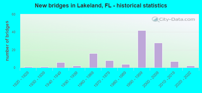
- New bridges - historical statistics
- 11920-1929
- 11930-1939
- 61940-1949
- 21950-1959
- 161960-1969
- 81970-1979
- 41980-1989
- 421990-1999
- 282000-2009
- 72010-2019
- 22020-2022
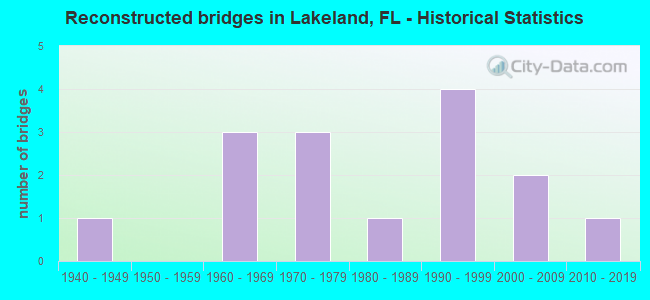
- Reconstructed bridges - Historical Statistics
- 11940-1949
- 01950-1959
- 31960-1969
- 31970-1979
- 11980-1989
- 41990-1999
- 22000-2009
- 12010-2019
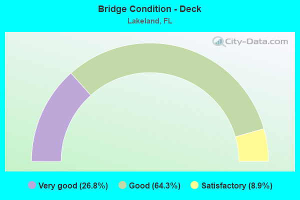
- Bridge Condition - Deck
- 26.8%Very good
- 64.3%Good
- 8.9%Satisfactory
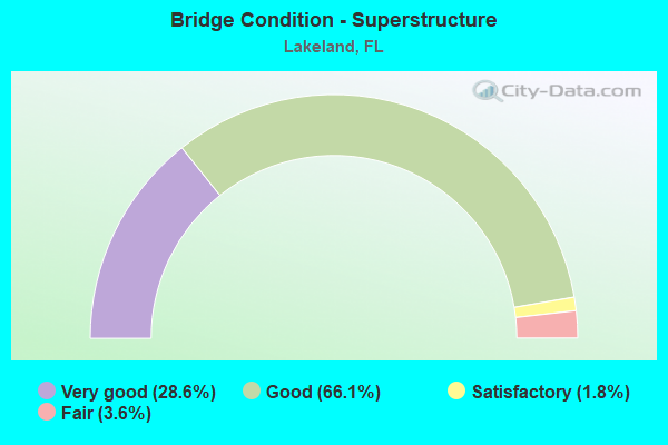
- Bridge Condition - Superstructure
- 28.6%Very good
- 66.1%Good
- 1.8%Satisfactory
- 3.6%Fair
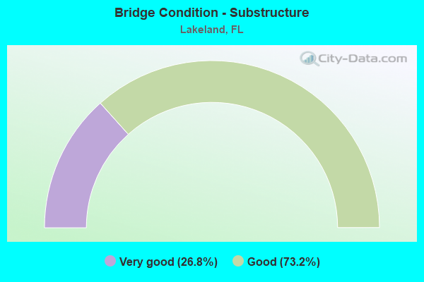
- Bridge Condition - Substructure
- 26.8%Very good
- 73.2%Good
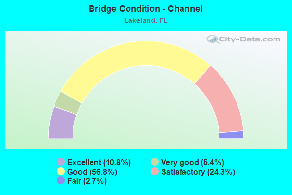
- Bridge Condition - Channel
- 10.8%Excellent
- 5.4%Very good
- 56.8%Good
- 24.3%Satisfactory
- 2.7%Fair
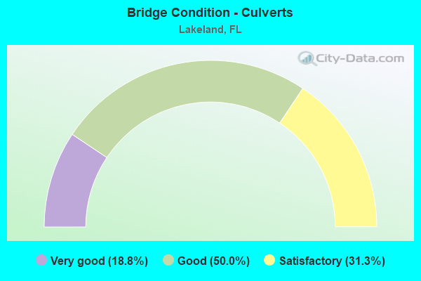
- Bridge Condition - Culverts
- 18.8%Very good
- 50.0%Good
- 31.3%Satisfactory
Find on map >> Show street view
Structure Number: 160298, Location: 1.0MI NORTH OF US-92 (Lat: 28.049064, Lng: -82.019133), Route carried "under" structure: Interstate 4, Year Built: 1998, Structure Length: 0. m, Average Daily Traffic: 102,500 (year 2020), Truck Traffic: 15%, Features Intersected: I-4 (SR-400), Facility Carried by Structure: GALLOWAY RD.
Minimum Vertical Clearance: 6.07m (19.91ft), Kilometerpoint: 4.118, Lanes on structure: 2, Lanes under structure: 8, Material/Design: Steel continuous, Design/Construction: Stringer/Multi-beam, Length of Maximum Span: 55.0m (180.4ft)
Find on map >> Show street view
Structure Number: 16031, Location: 1.3MI E OF KATHLEEN RD (Lat: 28.085389, Lng: -81.970525), Route carried "under" structure: US 98, Year Built: 2004, Structure Length: 0. m, Average Daily Traffic: 50,000 (year 2020), Truck Traffic: 6%, Features Intersected: US-98 (SR-35), Facility Carried by Structure: I-4 WB (SR-400)
Minimum Vertical Clearance: 5.09m (16.70ft), Kilometerpoint: 5.034, Lanes on structure: 3, Lanes under structure: 6, Material/Design: Steel, Design/Construction: Stringer/Multi-beam, Length of Maximum Span: 72.5m (237.9ft)
Find on map >> Show street view
Structure Number: 160311, Location: 1.3MI E OF KATHLEEN RD (Lat: 28.084978, Lng: -81.970125), Route carried "under" structure: US 98, Year Built: 2004, Structure Length: 0. m, Average Daily Traffic: 39,000 (year 2020), Truck Traffic: 5%, Features Intersected: US-98 (SR-35), Facility Carried by Structure: I-4 EB (SR-400)
Minimum Vertical Clearance: 5.46m (17.91ft), Kilometerpoint: 4.974, Lanes on structure: 3, Lanes under structure: 6, Material/Design: Steel, Design/Construction: Stringer/Multi-beam, Length of Maximum Span: 72.5m (237.9ft)
Find on map >> Show street view
Structure Number: 160322, Location: 0.9MI E OF US-98 (Lat: 28.093453, Lng: -81.958336), Route carried "under" structure: Interstate 4, Year Built: 2004, Structure Length: 0. m, Average Daily Traffic: 88,000 (year 2020), Truck Traffic: 16%, Features Intersected: I-4 (SR-400), Facility Carried by Structure: CARPENTERS WAY
Minimum Vertical Clearance: 5.43m (17.81ft), Kilometerpoint: 11.872, Lanes on structure: 2, Lanes under structure: 6, Material/Design: Prestressed concrete, Design/Construction: Stringer/Multi-beam, Length of Maximum Span: 48.8m (160.1ft)
Find on map >> Show street view
Structure Number: 160323, Location: 2.4 MI EAST OF US-98 (Lat: 28.110083, Lng: -81.942361), Route carried "under" structure: Interstate 4, Year Built: 2004, Structure Length: 0. m, Average Daily Traffic: 88,000 (year 2020), Truck Traffic: 16%, Features Intersected: I-4 (SR-400), Facility Carried by Structure: OLD COMBEE RD
Minimum Vertical Clearance: 5.55m (18.21ft), Kilometerpoint: 14.349, Lanes on structure: 2, Lanes under structure: 6, Material/Design: Steel continuous, Design/Construction: Stringer/Multi-beam, Length of Maximum Span: 54.1m (177.5ft)
Find on map >> Show street view
Structure Number: 160324, Location: 0.4 MI EAST OF SR-570 (Lat: 28.155667, Lng: -81.841806), Route carried "under" structure: Interstate 4, Year Built: 2004, Structure Length: 0. m, Average Daily Traffic: 85,157 (year 2020), Truck Traffic: 14%, Features Intersected: I-4 (SR-400), Facility Carried by Structure: MT OLIVE CHURCH RD
Minimum Vertical Clearance: 5.64m (18.50ft), Kilometerpoint: 25.712, Lanes on structure: 2, Lanes under structure: 6, Material/Design: Prestressed concrete, Design/Construction: Stringer/Multi-beam, Length of Maximum Span: 50.9m (167.0ft)
Find on map >> Show street view
Structure Number: 160325, Location: 0.1MI EAST OF SUTTON RD. (Lat: 28.054944, Lng: -82.011000), Route carried "under" structure: Interstate 4, Year Built: 2005, Structure Length: 0. m, Average Daily Traffic: 100,500 (year 2020), Truck Traffic: 17%, Features Intersected: I-4 (SR-400), Facility Carried by Structure: SWINDELL ROAD
Minimum Vertical Clearance: 6.37m (20.90ft), Kilometerpoint: 5.129, Lanes on structure: 2, Lanes under structure: 7, Material/Design: Steel continuous, Design/Construction: Stringer/Multi-beam, Length of Maximum Span: 77.0m (252.6ft)
Find on map >> Show street view
Structure Number: 160326, Location: 2.3 MI WEST OF US-98 (Lat: 28.062222, Lng: -82.000833), Route carried "under" structure: Interstate 4, Year Built: 2005, Structure Length: 0. m, Average Daily Traffic: 100,500 (year 2020), Truck Traffic: 17%, Features Intersected: I-4 (SR-400), Facility Carried by Structure: WEST 10TH ST.
Minimum Vertical Clearance: 6.31m (20.70ft), Kilometerpoint: 6.407, Lanes on structure: 2, Lanes under structure: 6, Material/Design: Steel continuous, Design/Construction: Stringer/Multi-beam, Length of Maximum Span: 77.0m (252.6ft)
Find on map >> Show street view
Structure Number: 160327, Location: 0.5 MI W OF KATHLEEN RD (Lat: 28.069678, Lng: -81.990881), Route carried "under" structure: Interstate 4, Year Built: 2005, Structure Length: 0. m, Average Daily Traffic: 100,500 (year 2020), Truck Traffic: 17%, Features Intersected: I-4 (SR-400), Facility Carried by Structure: W BELLA VISTA ST
Minimum Vertical Clearance: 5.70m (18.70ft), Kilometerpoint: 7.691, Lanes on structure: 2, Lanes under structure: 8, Material/Design: Steel continuous, Design/Construction: Stringer/Multi-beam, Length of Maximum Span: 76.7m (251.6ft)
Find on map >> Show street view
Structure Number: 160328, Location: 0.8 MI SOUTH OF CR-582 (Lat: 28.072736, Lng: -81.986858), Route carried "under" structure: Interstate 4, Year Built: 2005, Structure Length: 0. m, Average Daily Traffic: 100,500 (year 2020), Truck Traffic: 17%, Features Intersected: I-4 (SR-400), Facility Carried by Structure: SR-539 KATHLEEN RD
Minimum Vertical Clearance: 5.52m (18.11ft), Kilometerpoint: 8.237, Lanes on structure: 8, Lanes under structure: 6, Material/Design: Prestressed concrete, Design/Construction: Stringer/Multi-beam, Length of Maximum Span: 49.7m (163.1ft)
Find on map >> Show street view
Structure Number: 160329, Location: 0.7MI W OF US-98 (Lat: 28.080639, Lng: -81.976472), Route carried "under" structure: Interstate 4, Year Built: 2005, Structure Length: 0. m, Average Daily Traffic: 92,000 (year 2020), Truck Traffic: 16%, Features Intersected: I-4 (SR-400), Facility Carried by Structure: GRIFFIN RD(CR-582)
Minimum Vertical Clearance: 5.67m (18.60ft), Kilometerpoint: 9.561, Lanes on structure: 4, Lanes under structure: 8, Material/Design: Steel continuous, Design/Construction: Stringer/Multi-beam, Length of Maximum Span: 77.5m (254.3ft)
Find on map >> Show street view
Structure Number: 164506, Location: 0.1MI WEST OF MAIN ST. (Lat: 28.046383, Lng: -81.949133), Route carried "under" structure: City street , Year Built: 2003, Structure Length: 0. m, Average Daily Traffic: 2,100 (year 2020), Truck Traffic: 4%, Features Intersected: CSX RR & CITY STREETS, Facility Carried by Structure: US-98 (BARTOW RD.)
Minimum Vertical Clearance: 5.43m (17.81ft), Kilometerpoint: 0.171, Lanes on structure: 4, Lanes under structure: 2, Material/Design: Steel continuous, Design/Construction: Stringer/Multi-beam, Length of Maximum Span: 54.9m (180.1ft)
Find on map >> Show street view
Structure Number: 164506, Location: 0.1MI WEST OF MAIN ST. (Lat: 28.046383, Lng: -81.949133), Route carried "under" structure: City street , Year Built: 2003, Structure Length: 0. m, Average Daily Traffic: 1,000 (year 2019), Truck Traffic: 1%, Features Intersected: CSX RR & CITY STREETS, Facility Carried by Structure: US-98 (BARTOW RD.)
Minimum Vertical Clearance: 7.83m (25.69ft), Kilometerpoint: 0.000, Lanes on structure: 4, Lanes under structure: 2, Material/Design: Steel continuous, Design/Construction: Stringer/Multi-beam, Length of Maximum Span: 54.9m (180.1ft)
Find on map >> Show street view
Structure Number: 164509, Location: 1.3 MI S OF I-4 EAST (Lat: 28.135697, Lng: -81.840481), Route carried "under" structure: County highway , Year Built: 2011, Structure Length: 0. m, Average Daily Traffic: 30,370 (year 2011), Truck Traffic: 2%, Features Intersected: PACE RD, Facility Carried by Structure: SR 570 POLK 22.9
Minimum Vertical Clearance: 5.01m (16.44ft), Kilometerpoint: 0.000, Lanes on structure: 2, Lanes under structure: 8, Material/Design: Prestressed concrete, Design/Construction: Stringer/Multi-beam, Length of Maximum Span: 43.0m (141.1ft)
Find on map >> Show street view
Structure Number: 169005, Location: 0.6MI E/O N GALLOWAY RD (Lat: 28.037500, Lng: -82.010222), Route carried "under" structure: Other road 92, Year Built: 2020, Structure Length: 0. m, Features Intersected: WINSTON CREEK
Minimum Vertical Clearance: 30+ m (98+ ft), Kilometerpoint: 0.000, Lanes under structure: 1, Material/Design: Steel, Design/Construction: Truss - Thru, Length of Maximum Span: 24.4m (80.1ft)