Bridge Statistics for Laramie, Wyoming (WY)
Condition, Traffic, Stress, Structural Evaluation, Project Costs
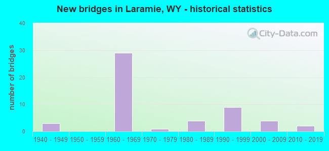
- New bridges - historical statistics
- 31940-1949
- 291960-1969
- 11970-1979
- 41980-1989
- 91990-1999
- 42000-2009
- 22010-2019

- Reconstructed bridges - Historical Statistics
- 31970-1979
- 01980-1989
- 21990-1999
- 22000-2009
- 12010-2019


- Bridge Condition - Deck
- 3.7%Very good
- 25.9%Good
- 44.4%Satisfactory
- 22.2%Fair
- 3.7%Poor

- Bridge Condition - Superstructure
- 7.4%Very good
- 48.1%Good
- 25.9%Satisfactory
- 14.8%Fair
- 3.7%Poor

- Bridge Condition - Substructure
- 51.9%Good
- 29.6%Satisfactory
- 11.1%Fair
- 3.7%Poor
- 3.7%Critical

- Bridge Condition - Channel
- 31.6%Very good
- 21.1%Good
- 47.4%Satisfactory

- Bridge Condition - Culverts
- 8.3%Very good
- 25.0%Good
- 58.3%Satisfactory
- 8.3%Fair
Find on map >> Show street view
Structure Number: AXB, Location: Walcott Jct - Laramie (Lat: 41.347258, Lng: -105.634092), Route carried "on" structure: Interstate 80, Year Built: 1969, Status: Open, Structure Length: 3.96m (12.99ft), Average Daily Traffic: 6,427 (year 2021), Truck Traffic: 56%, Average Future Daily Traffic: 8,998 (year 2041), Design Load: HS 20+Mod, Features Intersected: Al CR 55 / Welsh Lane
Minimum Vertical Clearance: 30+ m (98+ ft), Kilometerpoint: 496.439, Lanes on structure: 2, Lanes under structure: 2, Base Highway Network: Yes (Inventory Route: ML8, Subroute: 2), Owner: State Highway Agency, Approaching Roadway Width: 11.6m (38.1ft), Skew: 13 degrees, Material/Design: Concrete continuous, Design/Construction: Tee Beam, Number Of Spans In Main Unit: 3, Length of Maximum Span: 15.2m (49.9ft), Curb-To-Curb Width: 11.6m (38.1ft), Out-to-Out Width: 12.4m (40.7ft)
Condition: Deck: Fair, Superstructure: Satisfactory, Substructure: Good, Operating Rating: 55.3 metric tons, Method Used To Determine Operating Rating: Load Factor (LF), Inventory Rating: 33.6 metric tons, Method Used To Determine Inventory Rating: Load Factor (LF), Structural Evaluation: Equal to present minimum criteria, Deck Geometry: Equal to present minimum criteria, Underclear: Meets minimum limits, Approach Roadway Alignment: Equal to present desirable criteria, Designated Inspection Frequency: Every 24 months, Inspection Date: May 2020, Deck Structure Type: Concrete Cast-file-Place, Wearing Surface/Protective System: Wearing Surface: Epoxy Overlay
Find on map >> Show street view
Structure Number: AXC, Location: Walcott Jct - Laramie (Lat: 41.347472, Lng: -105.634086), Route carried "on" structure: Interstate 80, Year Built: 1969, Status: Open, Structure Length: 3.96m (12.99ft), Average Daily Traffic: 6,662 (year 2021), Truck Traffic: 56%, Average Future Daily Traffic: 9,327 (year 2041), Design Load: HS 20+Mod, Features Intersected: Al CR 55 / Welsh Lane
Minimum Vertical Clearance: 30+ m (98+ ft), Kilometerpoint: 496.199, Lanes on structure: 2, Lanes under structure: 2, Base Highway Network: Yes (Inventory Route: ML8, Subroute: 2), Owner: State Highway Agency, Approaching Roadway Width: 11.6m (38.1ft), Skew: 13 degrees, Material/Design: Concrete continuous, Design/Construction: Tee Beam, Number Of Spans In Main Unit: 3, Length of Maximum Span: 15.2m (49.9ft), Curb-To-Curb Width: 11.6m (38.1ft), Out-to-Out Width: 12.4m (40.7ft)
Condition: Deck: Satisfactory, Superstructure: Good, Substructure: Good, Operating Rating: 55.3 metric tons, Method Used To Determine Operating Rating: Load Factor (LF), Inventory Rating: 33.6 metric tons, Method Used To Determine Inventory Rating: Load Factor (LF), Structural Evaluation: Better than present minimum criteria, Deck Geometry: Equal to present minimum criteria, Underclear: Meets minimum limits, Approach Roadway Alignment: Equal to present desirable criteria, Designated Inspection Frequency: Every 24 months, Inspection Date: May 2020, Deck Structure Type: Concrete Cast-file-Place, Wearing Surface/Protective System: Wearing Surface: Epoxy Overlay
Find on map >> Show street view
Structure Number: AXD, Location: Laramie (Lat: 41.317844, Lng: -105.615075), Route carried "on" structure: Interstate 80, Year Built: 1963, Status: Open, Structure Length: 4.11m (13.48ft), Average Daily Traffic: 7,011 (year 2021), Truck Traffic: 95%, Average Future Daily Traffic: 9,815 (year 2041), Design Load: HS 20+Mod, Features Intersected: W. Madison Drive
Minimum Vertical Clearance: 30+ m (98+ ft), Kilometerpoint: 500.461, Lanes on structure: 2, Lanes under structure: 1, Base Highway Network: Yes (Inventory Route: ML8, Subroute: 3), Owner: State Highway Agency, Approaching Roadway Width: 10.7m (35.1ft), Skew: 13 degrees, Material/Design: Steel continuous, Design/Construction: Stringer/Multi-beam, Number Of Spans In Main Unit: 3, Length of Maximum Span: 15.5m (50.9ft), Curb-To-Curb Width: 11.6m (38.1ft), Out-to-Out Width: 13.0m (42.7ft)
Condition: Deck: Satisfactory, Superstructure: Satisfactory, Substructure: Satisfactory, Operating Rating: 60.8 metric tons, Method Used To Determine Operating Rating: Load Factor (LF), Inventory Rating: 36.3 metric tons, Method Used To Determine Inventory Rating: Load Factor (LF), Structural Evaluation: Equal to present minimum criteria, Deck Geometry: Equal to present minimum criteria, Approach Roadway Alignment: Equal to present desirable criteria, Designated Inspection Frequency: Every 24 months, Inspection Date: May 2020, Deck Structure Type: Concrete Cast-file-Place, Wearing Surface/Protective System: Wearing Surface: Latex Concrete
Find on map >> Show street view
Structure Number: AXE, Location: Laramie (Lat: 41.317839, Lng: -105.614822), Route carried "on" structure: Interstate 80, Year Built: 1963, Status: Open, Structure Length: 4.11m (13.48ft), Average Daily Traffic: 7,321 (year 2021), Truck Traffic: 44%, Average Future Daily Traffic: 10,249 (year 2041), Design Load: HS 20+Mod, Features Intersected: W. Madison Drive
Minimum Vertical Clearance: 30+ m (98+ ft), Kilometerpoint: 500.257, Lanes on structure: 2, Lanes under structure: 1, Base Highway Network: Yes (Inventory Route: ML8, Subroute: 3), Owner: State Highway Agency, Approaching Roadway Width: 10.7m (35.1ft), Skew: 13 degrees, Material/Design: Steel continuous, Design/Construction: Stringer/Multi-beam, Number Of Spans In Main Unit: 3, Length of Maximum Span: 15.5m (50.9ft), Curb-To-Curb Width: 11.6m (38.1ft), Out-to-Out Width: 13.0m (42.7ft)
Condition: Deck: Satisfactory, Superstructure: Fair, Substructure: Satisfactory, Operating Rating: 60.8 metric tons, Method Used To Determine Operating Rating: Load Factor (LF), Inventory Rating: 36.3 metric tons, Method Used To Determine Inventory Rating: Load Factor (LF), Structural Evaluation: Somewhat better than minimum adequacy, Deck Geometry: Equal to present minimum criteria, Approach Roadway Alignment: Equal to present desirable criteria, Designated Inspection Frequency: Every 24 months, Inspection Date: May 2020, Deck Structure Type: Concrete Cast-file-Place, Wearing Surface/Protective System: Wearing Surface: Latex Concrete
Find on map >> Show street view
Structure Number: AXJ, Location: Laramie (Lat: 41.301200, Lng: -105.608692), Route carried "on" structure: Interstate 80, Year Built: 1962, Year Reconstructed: 1997, Status: Open, Structure Length: 6.07m (19.91ft), Average Daily Traffic: 10,578 (year 2021), Truck Traffic: 63%, Average Future Daily Traffic: 14,809 (year 2041), Design Load: HS 20+Mod, Features Intersected: Laramie River
Minimum Vertical Clearance: 30+ m (98+ ft), Kilometerpoint: 502.521, Lanes on structure: 2, Base Highway Network: Yes (Inventory Route: ML8, Subroute: 3), Owner: State Highway Agency, Approaching Roadway Width: 12.2m (40.0ft), Skew: 10 degrees, Material/Design: Steel continuous, Design/Construction: Stringer/Multi-beam, Number Of Spans In Main Unit: 3, Length of Maximum Span: 22.9m (75.1ft), Curb-To-Curb Width: 12.2m (40.0ft), Out-to-Out Width: 13.0m (42.7ft)
Condition: Deck: Fair, Superstructure: Poor, Substructure: Poor, Channel: Very good, Operating Rating: 81.6 metric tons, Method Used To Determine Operating Rating: Load Factor (LF), Inventory Rating: 37.2 metric tons, Method Used To Determine Inventory Rating: Load Factor (LF), Structural Evaluation: Meets minimum limits, Deck Geometry: Better than present minimum criteria, Waterway Adequacy: Equal to present desirable criteria, Approach Roadway Alignment: Equal to present desirable criteria, Designated Inspection Frequency: Every 24 months, Inspection Date: May 2020, Deck Structure Type: Concrete Cast-file-Place, Wearing Surface/Protective System: Wearing Surface: Latex Concrete
Find on map >> Show street view
Structure Number: AXK, Location: Laramie (Lat: 41.301375, Lng: -105.608594), Route carried "on" structure: Interstate 80, Year Built: 1962, Year Reconstructed: 1997, Status: Open, Structure Length: 6.07m (19.91ft), Average Daily Traffic: 10,528 (year 2021), Truck Traffic: 44%, Average Future Daily Traffic: 14,739 (year 2041), Design Load: HS 20+Mod, Features Intersected: Laramie River
Minimum Vertical Clearance: 30+ m (98+ ft), Kilometerpoint: 502.289, Lanes on structure: 2, Base Highway Network: Yes (Inventory Route: ML8, Subroute: 3), Owner: State Highway Agency, Approaching Roadway Width: 12.2m (40.0ft), Skew: 10 degrees, Material/Design: Steel continuous, Design/Construction: Stringer/Multi-beam, Number Of Spans In Main Unit: 3, Length of Maximum Span: 22.9m (75.1ft), Curb-To-Curb Width: 12.2m (40.0ft), Out-to-Out Width: 13.0m (42.7ft)
Condition: Deck: Poor, Superstructure: Good, Substructure: Fair, Channel: Very good, Operating Rating: 81.6 metric tons, Method Used To Determine Operating Rating: Load Factor (LF), Inventory Rating: 37.2 metric tons, Method Used To Determine Inventory Rating: Load Factor (LF), Structural Evaluation: Somewhat better than minimum adequacy, Deck Geometry: Better than present minimum criteria, Waterway Adequacy: Equal to present desirable criteria, Approach Roadway Alignment: Equal to present desirable criteria, Designated Inspection Frequency: Every 24 months, Inspection Date: May 2020, Deck Structure Type: Concrete Cast-file-Place, Wearing Surface/Protective System: Wearing Surface: Latex Concrete
Find on map >> Show street view
Structure Number: AXP, Location: 15Th Street Laramie (Lat: 41.293417, Lng: -105.580464), Route carried "on" structure: City street 4203, Year Built: 1962, Year Reconstructed: 1983, Status: Open, Structure Length: 6.37m (20.90ft), Average Daily Traffic: 1,762 (year 2021), Truck Traffic: 3%, Average Future Daily Traffic: 2,467 (year 2041), Design Load: HS 20, Features Intersected: I-80, Facility Carried by Structure: 15th Street
Minimum Vertical Clearance: 30+ m (98+ ft), Kilometerpoint: 158.821, Lanes on structure: 2, Lanes under structure: 4, Owner: State Highway Agency, Approaching Roadway Width: 10.1m (33.1ft), Skew: 1 degrees, Material/Design: Concrete continuous, Design/Construction: Tee Beam, Number Of Spans In Main Unit: 4, Length of Maximum Span: 17.7m (58.1ft), Curb or Sidewalk Widths: Left: 0.0m, Right: 2.7m (8.9ft), Curb-To-Curb Width: 8.5m (27.9ft), Out-to-Out Width: 9.7m (31.8ft)
Condition: Deck: Satisfactory, Superstructure: Good, Substructure: Good, Operating Rating: 52.6 metric tons, Method Used To Determine Operating Rating: Load Factor (LF), Inventory Rating: 31.8 metric tons, Method Used To Determine Inventory Rating: Load Factor (LF), Structural Evaluation: Better than present minimum criteria, Deck Geometry: Somewhat better than minimum adequacy, Underclear: Meets minimum limits, Approach Roadway Alignment: Better than present minimum criteria, Length Of Structure Improvement: 6.37m (20.90ft), Designated Inspection Frequency: Every 24 months, Inspection Date: May 2020, Bridge Improvement Cost: $88,000, Roadway Improvement Cost: $9,000, Total Project Cost: $132,000, Deck Structure Type: Concrete Cast-file-Place, Wearing Surface/Protective System: Wearing Surface: Latex Concrete
Find on map >> Show street view
Structure Number: AXQ, Location: Laramie (Lat: 41.291436, Lng: -105.538211), Route carried "on" structure: County highway , Year Built: 1962, Status: Open, Structure Length: 6.16m (20.21ft), Average Daily Traffic: 406 (year 2021), Truck Traffic: 8%, Average Future Daily Traffic: 568 (year 2041), Design Load: HS 20, Features Intersected: I-80, Facility Carried by Structure: Vista Drive
Minimum Vertical Clearance: 30+ m (98+ ft), Kilometerpoint: 1.278, Lanes on structure: 2, Lanes under structure: 4, Owner: State Highway Agency, Approaching Roadway Width: 8.5m (27.9ft), Material/Design: Concrete continuous, Design/Construction: Tee Beam, Number Of Spans In Main Unit: 4, Length of Maximum Span: 17.1m (56.1ft), Curb or Sidewalk Widths: Left: 0.5m (1.6ft), Right: 0.5m (1.6ft), Curb-To-Curb Width: 8.5m (27.9ft), Out-to-Out Width: 9.7m (31.8ft)
Condition: Deck: Satisfactory, Superstructure: Satisfactory, Substructure: Satisfactory, Operating Rating: 61.7 metric tons, Method Used To Determine Operating Rating: Load Factor (LF), Inventory Rating: 36.3 metric tons, Method Used To Determine Inventory Rating: Load Factor (LF), Structural Evaluation: Equal to present minimum criteria, Deck Geometry: Somewhat better than minimum adequacy, Underclear: High priority of corrective action, Approach Roadway Alignment: Better than present minimum criteria, Length Of Structure Improvement: 0.30m (0.98ft), Designated Inspection Frequency: Every 24 months, Inspection Date: May 2020, Bridge Improvement Cost: $1,000, Roadway Improvement Cost: $1,000, Total Project Cost: $3,000 ( Estimate for 2015), Deck Structure Type: Concrete Cast-file-Place, Wearing Surface/Protective System: Wearing Surface: Bituminous
Find on map >> Show street view
Structure Number: AXS, Location: Laramie - Cheyenne (Lat: 41.276547, Lng: -105.512578), Route carried "on" structure: Interstate 80, Year Built: 1961, Status: Open, Structure Length: 2.04m (6.69ft), Average Daily Traffic: 8,005 (year 2021), Truck Traffic: 82%, Average Future Daily Traffic: 11,207 (year 2041), Design Load: HS 20+Mod, Features Intersected: Buck Sullivan Springs Rd
Minimum Vertical Clearance: 30+ m (98+ ft), Kilometerpoint: 511.522, Lanes on structure: 2, Lanes under structure: 1, Base Highway Network: Yes (Inventory Route: ML8, Subroute: 3), Owner: State Highway Agency, Approaching Roadway Width: 11.6m (38.1ft), Skew: 10 degrees, Material/Design: Concrete continuous, Design/Construction: Slab, Number Of Spans In Main Unit: 3, Length of Maximum Span: 7.6m (24.9ft), Curb-To-Curb Width: 11.6m (38.1ft), Out-to-Out Width: 12.5m (41.0ft)
Condition: Deck: Satisfactory, Superstructure: Satisfactory, Substructure: Satisfactory, Operating Rating: 40.5 metric tons, Method Used To Determine Operating Rating: Load Factor (LF), Inventory Rating: 24.1 metric tons, Method Used To Determine Inventory Rating: Load Factor (LF), Structural Evaluation: Somewhat better than minimum adequacy, Deck Geometry: Equal to present minimum criteria, Underclear: Better than present minimum criteria, Approach Roadway Alignment: Equal to present desirable criteria, Length Of Structure Improvement: 2.77m (9.09ft), Designated Inspection Frequency: Every 24 months, Inspection Date: May 2020, Bridge Improvement Cost: $12,000, Roadway Improvement Cost: $1,000, Total Project Cost: $14,000 ( Estimate for 2015), Deck Structure Type: Concrete Cast-file-Place, Wearing Surface/Protective System: Wearing Surface: Bituminous, Membrane: Preformed Fabric
Find on map >> Show street view
Structure Number: AXT, Location: Laramie - Cheyenne (Lat: 41.277014, Lng: -105.511694), Route carried "on" structure: Interstate 80, Year Built: 1961, Status: Open, Structure Length: 2.04m (6.69ft), Average Daily Traffic: 8,086 (year 2021), Truck Traffic: 44%, Average Future Daily Traffic: 11,320 (year 2041), Design Load: HS 20+Mod, Features Intersected: Buck Sullivan Springs Rd
Minimum Vertical Clearance: 30+ m (98+ ft), Kilometerpoint: 511.316, Lanes on structure: 2, Lanes under structure: 1, Base Highway Network: Yes (Inventory Route: ML8, Subroute: 3), Owner: State Highway Agency, Approaching Roadway Width: 11.6m (38.1ft), Skew: 10 degrees, Material/Design: Concrete continuous, Design/Construction: Slab, Number Of Spans In Main Unit: 3, Length of Maximum Span: 7.6m (24.9ft), Curb-To-Curb Width: 11.6m (38.1ft), Out-to-Out Width: 12.5m (41.0ft)
Condition: Deck: Satisfactory, Superstructure: Satisfactory, Substructure: Satisfactory, Operating Rating: 41.8 metric tons, Method Used To Determine Operating Rating: Load Factor (LF), Inventory Rating: 25.1 metric tons, Method Used To Determine Inventory Rating: Load Factor (LF), Structural Evaluation: Equal to present minimum criteria, Deck Geometry: Equal to present minimum criteria, Underclear: Meets minimum limits, Approach Roadway Alignment: Equal to present desirable criteria, Length Of Structure Improvement: 2.04m (6.69ft), Designated Inspection Frequency: Every 24 months, Inspection Date: May 2020, Bridge Improvement Cost: $20,000, Roadway Improvement Cost: $2,000, Total Project Cost: $30,000 ( Estimate for 2015), Deck Structure Type: Concrete Cast-file-Place, Wearing Surface/Protective System: Wearing Surface: Bituminous, Membrane: Preformed Fabric
Find on map >> Show street view
Structure Number: BLB, Location: Curtis Street Laramie (Lat: 41.326919, Lng: -105.596397), Route carried "on" structure: Business US 80, Year Built: 1963, Year Reconstructed: 2000, Status: Posted for load, Structure Length: 7.44m (24.41ft), Average Daily Traffic: 1,480 (year 2021), Truck Traffic: 4%, Average Future Daily Traffic: 2,072 (year 2041), Design Load: HS 20, Features Intersected: UPRR
Minimum Vertical Clearance: 30+ m (98+ ft), Kilometerpoint: 1.716, Lanes on structure: 3, Owner: State Highway Agency, Approaching Roadway Width: 15.5m (50.9ft), Material/Design: Steel continuous, Design/Construction: Stringer/Multi-beam, Number Of Spans In Main Unit: 3, Length of Maximum Span: 42.1m (138.1ft), Curb or Sidewalk Widths: Left: 0.0m, Right: 2.4m (7.9ft), Curb-To-Curb Width: 15.5m (50.9ft), Out-to-Out Width: 19.2m (63.0ft)
Condition: Deck: Satisfactory, Superstructure: Satisfactory, Substructure: Good, Operating Rating: 38.6 metric tons, Method Used To Determine Operating Rating: Load Factor (LF), Inventory Rating: 23.2 metric tons, Method Used To Determine Inventory Rating: Load Factor (LF), Structural Evaluation: Equal to present minimum criteria, Deck Geometry: Equal to present minimum criteria, Underclear: High priority of corrective action, Approach Roadway Alignment: Better than present minimum criteria, Designated Inspection Frequency: Every 24 months, Other Special Inspection Frequency: Every 60 months, Inspection Date: May 2020, Other Special Inspection Date: November 2021, Deck Structure Type: Concrete Cast-file-Place, Wearing Surface/Protective System: Deck Protection: Epoxy Coated Reinforcing
Find on map >> Show street view
Structure Number: BUU, Location: Laramie (Lat: 41.299797, Lng: -105.594817), Route carried "on" structure: US 287, Year Built: 1963, Status: Posted for load, Structure Length: 1.25m (4.10ft), Average Daily Traffic: 3,781 (year 2021), Truck Traffic: 6%, Average Future Daily Traffic: 5,293 (year 2041), Design Load: HS 20, Features Intersected: Spring Creek
Minimum Vertical Clearance: 30+ m (98+ ft), Kilometerpoint: 529.440, Lanes on structure: 4, Base Highway Network: Yes (Inventory Route: ML2, Subroute: 2), Owner: State Highway Agency, Approaching Roadway Width: 14.6m (47.9ft), Material/Design: Concrete continuous, Design/Construction: Culvert, Number Of Spans In Main Unit: 3, Length of Maximum Span: 4.7m (15.4ft), Curb-To-Curb Width: 21.9m (71.9ft), Out-to-Out Width: 22.9m (75.1ft)
Condition: Channel: Very good, Culverts: Satisfactory, Operating Rating: 23.3 metric tons, Method Used To Determine Operating Rating: Load Factor (LF), Inventory Rating: 14.0 metric tons, Method Used To Determine Inventory Rating: Load Factor (LF), Structural Evaluation: Meets minimum limits, Deck Geometry: Superior to present desirable criteria, Waterway Adequacy: Equal to present desirable criteria, Approach Roadway Alignment: Equal to present desirable criteria, Bridge Posting: Required (Relationship of Operating Rating to Maximum Legal Load: > 39.9% below), Designated Inspection Frequency: Every 12 months, Inspection Date: May 2021, Deck Structure Type: Concrete Precast Panels, Wearing Surface/Protective System: Wearing Surface: Bituminous
Find on map >> Show street view
Structure Number: CLS, Location: Laramie Grand Ave Intg (Lat: 41.291278, Lng: -105.528683), Route carried "on" structure: Business US 55, Year Built: 1962, Status: Open, Structure Length: 6.77m (22.21ft), Average Daily Traffic: 1,733 (year 2021), Truck Traffic: 12%, Average Future Daily Traffic: 2,426 (year 2041), Design Load: HS 20, Features Intersected: I-80, Facility Carried by Structure: I-80 EBL On Ramp
Minimum Vertical Clearance: 30.48m (100.00ft), Kilometerpoint: 0.423, Lanes on structure: 1, Lanes under structure: 4, Base Highway Network: Yes, Owner: State Highway Agency, Approaching Roadway Width: 6.1m (20.0ft), Skew: 2 degrees, Material/Design: Concrete continuous, Design/Construction: Tee Beam, Number Of Spans In Main Unit: 4, Length of Maximum Span: 19.2m (63.0ft), Curb or Sidewalk Widths: Left: 0.0m, Right: 0.4m (1.3ft), Curb-To-Curb Width: 6.1m (20.0ft), Out-to-Out Width: 7.3m (24.0ft)
Condition: Deck: Fair, Superstructure: Fair, Substructure: Satisfactory, Operating Rating: 59.0 metric tons, Method Used To Determine Operating Rating: Load Factor (LF), Inventory Rating: 35.4 metric tons, Method Used To Determine Inventory Rating: Load Factor (LF), Structural Evaluation: Somewhat better than minimum adequacy, Deck Geometry: High priority of replacement, Underclear: High priority of corrective action, Approach Roadway Alignment: Equal to present desirable criteria, Length Of Structure Improvement: 6.71m (22.01ft), Designated Inspection Frequency: Every 24 months, Inspection Date: May 2021, Bridge Improvement Cost: $275,000, Roadway Improvement Cost: $28,000, Total Project Cost: $454,000 ( Estimate for 2014), Deck Structure Type: Concrete Cast-file-Place
Find on map >> Show street view
Structure Number: CXY, Location: Curtis Street Laramie (Lat: 41.327628, Lng: -105.607719), Route carried "on" structure: Business US 80, Year Built: 1963, Year Reconstructed: 2000, Status: Open, Structure Length: 6.10m (20.01ft), Average Daily Traffic: 5,976 (year 2021), Truck Traffic: 4%, Average Future Daily Traffic: 8,366 (year 2041), Design Load: HS 20, Features Intersected: Laramie River
Minimum Vertical Clearance: 30+ m (98+ ft), Kilometerpoint: 0.761, Lanes on structure: 3, Owner: State Highway Agency, Approaching Roadway Width: 15.8m (51.8ft), Skew: 4 degrees, Material/Design: Steel continuous, Design/Construction: Stringer/Multi-beam, Number Of Spans In Main Unit: 3, Length of Maximum Span: 22.9m (75.1ft), Curb or Sidewalk Widths: Left: 0.0m, Right: 2.4m (7.9ft), Curb-To-Curb Width: 15.5m (50.9ft), Out-to-Out Width: 19.0m (62.3ft)
Condition: Deck: Good, Superstructure: Good, Substructure: Good, Channel: Very good, Operating Rating: 55.5 metric tons, Method Used To Determine Operating Rating: Load Factor (LF), Inventory Rating: 33.3 metric tons, Method Used To Determine Inventory Rating: Load Factor (LF), Structural Evaluation: Better than present minimum criteria, Deck Geometry: Equal to present minimum criteria, Waterway Adequacy: Equal to present desirable criteria, Approach Roadway Alignment: Equal to present desirable criteria, Designated Inspection Frequency: Every 24 months, Inspection Date: May 2021, Deck Structure Type: Concrete Cast-file-Place, Wearing Surface/Protective System: Deck Protection: Epoxy Coated Reinforcing
Find on map >> Show street view
Structure Number: CXZ, Location: Curtis Street Laramie (Lat: 41.327908, Lng: -105.616247), Route carried "on" structure: Business US 4200, Year Built: 1969, Status: Open, Structure Length: 6.40m (21.00ft), Average Daily Traffic: 9,462 (year 2021), Truck Traffic: 5%, Average Future Daily Traffic: 13,247 (year 2041), Design Load: HS 20, Features Intersected: I-80, Facility Carried by Structure: I-80 Bus.
Minimum Vertical Clearance: 30+ m (98+ ft), Kilometerpoint: 0.042, Lanes on structure: 2, Lanes under structure: 4, Owner: State Highway Agency, Approaching Roadway Width: 9.8m (32.2ft), Material/Design: Concrete continuous, Design/Construction: Box Beam or Girders - Multiple, Number Of Spans In Main Unit: 2, Length of Maximum Span: 31.6m (103.7ft), Curb-To-Curb Width: 9.8m (32.2ft), Out-to-Out Width: 10.6m (34.8ft)
Condition: Deck: Satisfactory, Superstructure: Fair, Substructure: Good, Operating Rating: 54.9 metric tons, Method Used To Determine Operating Rating: Load Factor (LF), Inventory Rating: 32.7 metric tons, Method Used To Determine Inventory Rating: Load Factor (LF), Structural Evaluation: Somewhat better than minimum adequacy, Deck Geometry: Meets minimum limits, Underclear: Somewhat better than minimum adequacy, Approach Roadway Alignment: Equal to present desirable criteria, Length Of Structure Improvement: 0.06m (0.20ft), Designated Inspection Frequency: Every 24 months, Inspection Date: May 2021, Bridge Improvement Cost: $1,000, Roadway Improvement Cost: $1,000, Total Project Cost: $3,000 ( Estimate for 2014), Deck Structure Type: Concrete Cast-file-Place, Wearing Surface/Protective System: Wearing Surface: Bituminous
Find on map >> Show street view
Structure Number: DCZ, Location: Laramie (Lat: 41.314678, Lng: -105.605447), Route carried "on" structure: State highway 130, Year Built: 1977, Year Reconstructed: 2018, Status: Open, Structure Length: 5.39m (17.68ft), Average Daily Traffic: 10,639 (year 2021), Truck Traffic: 2%, Average Future Daily Traffic: 14,895 (year 2041), Design Load: HS 20, Features Intersected: Laramie River, Facility Carried by Structure: Snowy Range Road
Minimum Vertical Clearance: 30+ m (98+ ft), Kilometerpoint: 162.143, Lanes on structure: 4, Base Highway Network: Yes, Owner: State Highway Agency, Approaching Roadway Width: 18.8m (61.7ft), Material/Design: Steel continuous, Design/Construction: Stringer/Multi-beam, Number Of Spans In Main Unit: 3, Length of Maximum Span: 20.7m (67.9ft), Curb or Sidewalk Widths: Left: 0.0m, Right: 3.0m (9.8ft), Curb-To-Curb Width: 15.8m (51.8ft), Out-to-Out Width: 20.0m (65.6ft)
Condition: Deck: Satisfactory, Superstructure: Good, Substructure: Good, Channel: Very good, Operating Rating: 51.7 metric tons, Method Used To Determine Operating Rating: Load Factor (LF), Inventory Rating: 30.8 metric tons, Method Used To Determine Inventory Rating: Load Factor (LF), Structural Evaluation: Better than present minimum criteria, Deck Geometry: Meets minimum limits, Waterway Adequacy: Equal to present desirable criteria, Approach Roadway Alignment: Equal to present desirable criteria, Designated Inspection Frequency: Every 24 months, Inspection Date: May 2020, Deck Structure Type: Concrete Cast-file-Place, Wearing Surface/Protective System: Wearing Surface: Epoxy Overlay
Find on map >> Show street view
Structure Number: DLN, Location: Laramie - Grand Ave (Lat: 41.307986, Lng: -105.552536), Route carried "on" structure: Business US 80, Year Built: 1981, Status: Open, Structure Length: 1.83m (6.00ft), Average Daily Traffic: 17,002 (year 2021), Truck Traffic: 4%, Average Future Daily Traffic: 23,803 (year 2041), Design Load: HS 20, Features Intersected: Spring Creek
Minimum Vertical Clearance: 30+ m (98+ ft), Kilometerpoint: 532.105, Lanes on structure: 5, Base Highway Network: Yes, Owner: State Highway Agency, Approaching Roadway Width: 21.0m (68.9ft), Material/Design: Steel, Design/Construction: Stringer/Multi-beam, Number Of Spans In Main Unit: 1, Length of Maximum Span: 17.7m (58.1ft), Curb or Sidewalk Widths: Left: 1.5m (4.9ft), Right: 1.5m (4.9ft), Curb-To-Curb Width: 20.7m (67.9ft), Out-to-Out Width: 25.0m (82.0ft)
Condition: Deck: Satisfactory, Superstructure: Good, Substructure: Good, Channel: Good, Operating Rating: 96.2 metric tons, Method Used To Determine Operating Rating: Load Factor (LF), Inventory Rating: 58.1 metric tons, Method Used To Determine Inventory Rating: Load Factor (LF), Structural Evaluation: Better than present minimum criteria, Deck Geometry: Somewhat better than minimum adequacy, Waterway Adequacy: Equal to present desirable criteria, Approach Roadway Alignment: Equal to present desirable criteria, Length Of Structure Improvement: 25.60m (83.99ft), Designated Inspection Frequency: Every 24 months, Inspection Date: May 2020, Bridge Improvement Cost: $70,000, Roadway Improvement Cost: $7,000, Total Project Cost: $105,000 ( Estimate for 2014), Deck Structure Type: Concrete Cast-file-Place, Wearing Surface/Protective System: Deck Protection: Epoxy Coated Reinforcing
Find on map >> Show street view
Structure Number: DOH, Location: 9Th Street-Laramie (Lat: 41.302617, Lng: -105.586539), Route carried "on" structure: City street 2507, Year Built: 1960, Status: Open, Structure Length: 1.10m (3.61ft), Average Daily Traffic: 1,762 (year 2021), Truck Traffic: 3%, Average Future Daily Traffic: 2,467 (year 2041), Features Intersected: Spring Creek, Facility Carried by Structure: 9th Street
Minimum Vertical Clearance: 30+ m (98+ ft), Kilometerpoint: 159.830, Lanes on structure: 2, Owner: City or Municipal Highway Agency, Approaching Roadway Width: 14.3m (46.9ft), Material/Design: Concrete continuous, Design/Construction: Culvert, Number Of Spans In Main Unit: 3, Length of Maximum Span: 4.2m (13.8ft), Curb or Sidewalk Widths: Left: 1.5m (4.9ft), Right: 1.5m (4.9ft), Curb-To-Curb Width: 12.2m (40.0ft), Out-to-Out Width: 15.8m (51.8ft)
Condition: Channel: Satisfactory, Culverts: Good, Operating Rating: 32.7 metric tons, Method Used To Determine Operating Rating: Field evaluation and documented engineering judgment, Inventory Rating: 32.7 metric tons, Method Used To Determine Inventory Rating: Field evaluation and documented engineering judgment, Structural Evaluation: Better than present minimum criteria, Deck Geometry: Better than present minimum criteria, Waterway Adequacy: Equal to present desirable criteria, Approach Roadway Alignment: Equal to present desirable criteria, Length Of Structure Improvement: 0.46m (1.51ft), Designated Inspection Frequency: Every 24 months, Inspection Date: November 2020, Bridge Improvement Cost: $1,000,000, Roadway Improvement Cost: $100,000, Total Project Cost: $1,500,000, Deck Structure Type: Concrete Cast-file-Place, Wearing Surface/Protective System: Wearing Surface: Bituminous
Find on map >> Show street view
Structure Number: EAP, Location: Laramie (Lat: 41.302733, Lng: -105.577086), Route carried "on" structure: City street 250-3, Year Built: 1983, Status: Open, Structure Length: 1.05m (3.44ft), Average Daily Traffic: 250 (year 2021), Truck Traffic: 5%, Average Future Daily Traffic: 350 (year 2041), Features Intersected: Spring Creek, Facility Carried by Structure: 16th Street
Minimum Vertical Clearance: 30+ m (98+ ft), Kilometerpoint: 160.950, Lanes on structure: 2, Owner: City or Municipal Highway Agency, Approaching Roadway Width: 14.0m (45.9ft), Material/Design: Concrete continuous, Design/Construction: Culvert, Number Of Spans In Main Unit: 3, Length of Maximum Span: 4.2m (13.8ft), Curb or Sidewalk Widths: Left: 1.3m (4.3ft), Right: 1.3m (4.3ft), Curb-To-Curb Width: 13.9m (45.6ft), Out-to-Out Width: 17.9m (58.7ft)
Condition: Channel: Satisfactory, Culverts: Satisfactory, Operating Rating: 32.7 metric tons, Method Used To Determine Operating Rating: Field evaluation and documented engineering judgment, Inventory Rating: 32.7 metric tons, Method Used To Determine Inventory Rating: Field evaluation and documented engineering judgment, Structural Evaluation: Equal to present minimum criteria, Deck Geometry: Superior to present desirable criteria, Waterway Adequacy: Equal to present desirable criteria, Approach Roadway Alignment: Equal to present desirable criteria, Length Of Structure Improvement: 3.29m (10.79ft), Designated Inspection Frequency: Every 24 months, Inspection Date: November 2020, Bridge Improvement Cost: $5,000, Roadway Improvement Cost: $1,000, Total Project Cost: $8,000, Deck Structure Type: Concrete Cast-file-Place, Wearing Surface/Protective System: Wearing Surface: Bituminous
Find on map >> Show street view
Structure Number: EAQ, Location: Laramie (Lat: 41.302836, Lng: -105.575164), Route carried "on" structure: City street 250-4, Year Built: 1960, Year Reconstructed: 1983, Status: Open, Structure Length: 1.05m (3.44ft), Average Daily Traffic: 250 (year 2021), Truck Traffic: 1%, Average Future Daily Traffic: 350 (year 2041), Design Load: HS 20, Features Intersected: Spring Creek, Facility Carried by Structure: S. 17th Street
Minimum Vertical Clearance: 30+ m (98+ ft), Kilometerpoint: 159.948, Lanes on structure: 2, Owner: City or Municipal Highway Agency, Approaching Roadway Width: 13.7m (44.9ft), Material/Design: Concrete continuous, Design/Construction: Culvert, Number Of Spans In Main Unit: 3, Length of Maximum Span: 4.3m (14.1ft), Curb or Sidewalk Widths: Left: 1.3m (4.3ft), Right: 1.3m (4.3ft), Curb-To-Curb Width: 13.7m (44.9ft), Out-to-Out Width: 17.4m (57.1ft)
Condition: Channel: Satisfactory, Culverts: Satisfactory, Operating Rating: 54.5 metric tons, Method Used To Determine Operating Rating: Field evaluation and documented engineering judgment, Inventory Rating: 32.7 metric tons, Method Used To Determine Inventory Rating: Field evaluation and documented engineering judgment, Structural Evaluation: Equal to present minimum criteria, Deck Geometry: Superior to present desirable criteria, Waterway Adequacy: Equal to present desirable criteria, Approach Roadway Alignment: Equal to present desirable criteria, Designated Inspection Frequency: Every 24 months, Inspection Date: November 2020, Deck Structure Type: Concrete Cast-file-Place, Wearing Surface/Protective System: Wearing Surface: Bituminous
Find on map >> Show street view
Structure Number: EOB, Location: 15Th Street In Laramie (Lat: 41.302625, Lng: -105.578592), Route carried "on" structure: City street 15, Year Built: 1960, Year Reconstructed: 1983, Status: Open, Structure Length: 1.04m (3.41ft), Average Daily Traffic: 1,835 (year 2021), Truck Traffic: 3%, Average Future Daily Traffic: 2,569 (year 2041), Design Load: HS 20, Features Intersected: Spring Creek
Minimum Vertical Clearance: 30+ m (98+ ft), Kilometerpoint: 159.892, Lanes on structure: 2, Owner: City or Municipal Highway Agency, Approaching Roadway Width: 15.5m (50.9ft), Material/Design: Concrete continuous, Design/Construction: Culvert, Number Of Spans In Main Unit: 3, Length of Maximum Span: 4.3m (14.1ft), Curb or Sidewalk Widths: Left: 1.8m (5.9ft), Right: 1.8m (5.9ft), Curb-To-Curb Width: 15.5m (50.9ft), Out-to-Out Width: 19.2m (63.0ft)
Condition: Channel: Very good, Culverts: Fair, Operating Rating: 32.7 metric tons, Method Used To Determine Operating Rating: Field evaluation and documented engineering judgment, Inventory Rating: 32.7 metric tons, Method Used To Determine Inventory Rating: Field evaluation and documented engineering judgment, Structural Evaluation: Somewhat better than minimum adequacy, Deck Geometry: Superior to present desirable criteria, Waterway Adequacy: Equal to present desirable criteria, Approach Roadway Alignment: Better than present minimum criteria, Length Of Structure Improvement: 0.18m (0.59ft), Designated Inspection Frequency: Every 24 months, Inspection Date: November 2020, Bridge Improvement Cost: $1,000, Roadway Improvement Cost: $1,000, Total Project Cost: $3,000, Deck Structure Type: Concrete Cast-file-Place, Wearing Surface/Protective System: Wearing Surface: Bituminous
Find on map >> Show street view
Structure Number: EOW, Location: 2nd Street - Laramie (Lat: 41.299214, Lng: -105.596183), Route carried "on" structure: City street 250-5, Year Built: 1983, Status: Open, Structure Length: 1.77m (5.81ft), Average Daily Traffic: 849 (year 2021), Truck Traffic: 16%, Average Future Daily Traffic: 1,189 (year 2041), Features Intersected: Spring Creek, Facility Carried by Structure: S. 2nd Street
Minimum Vertical Clearance: 30+ m (98+ ft), Kilometerpoint: 159.378, Lanes on structure: 2, Owner: City or Municipal Highway Agency, Approaching Roadway Width: 9.1m (29.9ft), Skew: 4 degrees, Material/Design: Concrete continuous, Design/Construction: Culvert, Number Of Spans In Main Unit: 4, Length of Maximum Span: 3.0m (9.8ft), Curb-To-Curb Width: 9.2m (30.2ft), Out-to-Out Width: 10.0m (32.8ft)
Condition: Channel: Satisfactory, Culverts: Satisfactory, Operating Rating: 54.5 metric tons, Method Used To Determine Operating Rating: Field evaluation and documented engineering judgment, Inventory Rating: 32.7 metric tons, Method Used To Determine Inventory Rating: Field evaluation and documented engineering judgment, Structural Evaluation: Equal to present minimum criteria, Deck Geometry: Equal to present minimum criteria, Waterway Adequacy: Equal to present desirable criteria, Approach Roadway Alignment: Equal to present desirable criteria, Length Of Structure Improvement: 0.61m (2.00ft), Designated Inspection Frequency: Every 24 months, Inspection Date: November 2020, Bridge Improvement Cost: $3,000, Total Project Cost: $5,000, Deck Structure Type: Concrete Cast-file-Place, Wearing Surface/Protective System: Wearing Surface: Bituminous
Find on map >> Show street view
Structure Number: EUM, Location: Laramie (Lat: 41.302617, Lng: -105.581303), Route carried "on" structure: City street 250-2, Year Built: 1983, Status: Posted for load, Structure Length: 1.02m (3.35ft), Average Daily Traffic: 479 (year 2021), Truck Traffic: 5%, Average Future Daily Traffic: 671 (year 2041), Design Load: HS 20, Features Intersected: Spring Creek, Facility Carried by Structure: S. 13th Street
Minimum Vertical Clearance: 30+ m (98+ ft), Kilometerpoint: 159.882, Lanes on structure: 2, Owner: City or Municipal Highway Agency, Approaching Roadway Width: 14.0m (45.9ft), Material/Design: Concrete continuous, Design/Construction: Culvert, Number Of Spans In Main Unit: 3, Length of Maximum Span: 3.3m (10.8ft), Curb or Sidewalk Widths: Left: 1.2m (3.9ft), Right: 1.2m (3.9ft), Curb-To-Curb Width: 14.1m (46.3ft), Out-to-Out Width: 17.7m (58.1ft)
Condition: Channel: Good, Culverts: Satisfactory, Operating Rating: 54.5 metric tons, Method Used To Determine Operating Rating: Field evaluation and documented engineering judgment, Inventory Rating: 32.7 metric tons, Method Used To Determine Inventory Rating: Field evaluation and documented engineering judgment, Structural Evaluation: Equal to present minimum criteria, Deck Geometry: Superior to present desirable criteria, Waterway Adequacy: Equal to present desirable criteria, Approach Roadway Alignment: Equal to present minimum criteria, Designated Inspection Frequency: Every 24 months, Inspection Date: November 2020, Deck Structure Type: Concrete Cast-file-Place, Wearing Surface/Protective System: Wearing Surface: Bituminous
Find on map >> Show street view
Structure Number: FRH, Location: Arrx 29 Mi N. Of Cheyenne (Lat: 41.575481, Lng: -104.848422), Route carried "on" structure: County highway 123-2, Year Built: 1991, Status: Open, Structure Length: 2.12m (6.96ft), Average Daily Traffic: 25 (year 2021), Truck Traffic: 8%, Average Future Daily Traffic: 35 (year 2041), Design Load: HS 20, Features Intersected: South Fork Bear Creek
Minimum Vertical Clearance: 30+ m (98+ ft), Kilometerpoint: 3.822, Lanes on structure: 1, Owner: County Highway Agency, Approaching Roadway Width: 7.6m (24.9ft), Material/Design: Steel, Design/Construction: Culvert, Number Of Spans In Main Unit: 8, Length of Maximum Span: 1.8m (5.9ft)
Condition: Channel: Satisfactory, Culverts: Satisfactory, Operating Rating: 32.7 metric tons, Method Used To Determine Operating Rating: Field evaluation and documented engineering judgment, Inventory Rating: 32.7 metric tons, Method Used To Determine Inventory Rating: Field evaluation and documented engineering judgment, Structural Evaluation: Equal to present minimum criteria, Waterway Adequacy: Better than present minimum criteria, Approach Roadway Alignment: Equal to present minimum criteria, Length Of Structure Improvement: 6.71m (22.01ft), Designated Inspection Frequency: Every 24 months, Inspection Date: December 2020, Bridge Improvement Cost: $18,000, Roadway Improvement Cost: $30,000, Total Project Cost: $50,000
Find on map >> Show street view
Structure Number: GBB, Location: Laramie - Cheyenne (Lat: 41.274378, Lng: -105.508733), Route carried "on" structure: Interstate 80, Year Built: 1946, Status: Open, Structure Length: 0.61m (2.00ft), Average Daily Traffic: 8,005 (year 2021), Truck Traffic: 82%, Average Future Daily Traffic: 11,207 (year 2041), Features Intersected: Unnamed Draw
Minimum Vertical Clearance: 30+ m (98+ ft), Kilometerpoint: 511.924, Lanes on structure: 2, Base Highway Network: Yes (Inventory Route: ML8, Subroute: 3), Owner: State Highway Agency, Approaching Roadway Width: 11.6m (38.1ft), Skew: 12 degrees, Material/Design: Concrete, Design/Construction: Culvert, Number Of Spans In Main Unit: 2, Length of Maximum Span: 2.7m (8.9ft)
Condition: Channel: Satisfactory, Culverts: Good, Operating Rating: 41.7 metric tons, Method Used To Determine Operating Rating: Field evaluation and documented engineering judgment, Inventory Rating: 32.7 metric tons, Method Used To Determine Inventory Rating: Field evaluation and documented engineering judgment, Structural Evaluation: Better than present minimum criteria, Waterway Adequacy: Equal to present desirable criteria, Approach Roadway Alignment: Equal to present desirable criteria, Designated Inspection Frequency: Every 24 months, Inspection Date: March 2020
Find on map >> Show street view
Structure Number: GBC, Location: Laramie - Cheyenne (Lat: 41.274658, Lng: -105.506075), Route carried "on" structure: Interstate 80, Year Built: 1946, Status: Open, Structure Length: 0.61m (2.00ft), Average Daily Traffic: 8,086 (year 2021), Truck Traffic: 44%, Average Future Daily Traffic: 11,320 (year 2041), Features Intersected: Unnamed Draw
Minimum Vertical Clearance: 30+ m (98+ ft), Kilometerpoint: 511.855, Lanes on structure: 2, Base Highway Network: Yes (Inventory Route: ML8, Subroute: 3), Owner: State Highway Agency, Approaching Roadway Width: 11.6m (38.1ft), Skew: 12 degrees, Material/Design: Concrete, Design/Construction: Culvert, Number Of Spans In Main Unit: 2, Length of Maximum Span: 2.7m (8.9ft)
Condition: Channel: Satisfactory, Culverts: Good, Operating Rating: 41.7 metric tons, Method Used To Determine Operating Rating: Field evaluation and documented engineering judgment, Inventory Rating: 32.7 metric tons, Method Used To Determine Inventory Rating: Field evaluation and documented engineering judgment, Structural Evaluation: Better than present minimum criteria, Waterway Adequacy: Equal to present desirable criteria, Approach Roadway Alignment: Equal to present desirable criteria, Designated Inspection Frequency: Every 24 months, Inspection Date: March 2020
Find on map >> Show street view
Structure Number: GBD, Location: Laramie-East (Lat: 41.271667, Lng: -105.493903), Route carried "on" structure: Interstate 80, Year Built: 1946, Status: Open, Structure Length: 0.63m (2.07ft), Average Daily Traffic: 8,005 (year 2021), Truck Traffic: 82%, Average Future Daily Traffic: 11,207 (year 2041), Design Load: HS 20, Features Intersected: Unnamed Draw
Minimum Vertical Clearance: 30+ m (98+ ft), Kilometerpoint: 513.231, Lanes on structure: 5, Base Highway Network: Yes, Owner: State Highway Agency, Approaching Roadway Width: 27.4m (89.9ft), Skew: 4 degrees, Material/Design: Concrete, Design/Construction: Culvert, Number Of Spans In Main Unit: 2, Length of Maximum Span: 2.1m (6.9ft)
Condition: Channel: Good, Culverts: Satisfactory, Operating Rating: 33.9 metric tons, Method Used To Determine Operating Rating: Load Factor (LF), Inventory Rating: 20.2 metric tons, Method Used To Determine Inventory Rating: Load Factor (LF), Structural Evaluation: Somewhat better than minimum adequacy, Waterway Adequacy: Equal to present desirable criteria, Approach Roadway Alignment: Equal to present desirable criteria, Designated Inspection Frequency: Every 24 months, Inspection Date: March 2020
Find on map >> Show street view
Structure Number: KLH, Location: Laramie Marginal (Lat: 41.309225, Lng: -105.614336), Route carried "on" structure: Interstate 80, Year Built: 1997, Status: Open, Structure Length: 4.60m (15.09ft), Average Daily Traffic: 7,011 (year 2021), Truck Traffic: 95%, Average Future Daily Traffic: 9,815 (year 2041), Design Load: HS 25 or greater, Features Intersected: Snowy Range Road
Minimum Vertical Clearance: 30+ m (98+ ft), Kilometerpoint: 501.420, Lanes on structure: 2, Lanes under structure: 5, Base Highway Network: Yes (Inventory Route: ML8, Subroute: 3), Owner: State Highway Agency, Approaching Roadway Width: 12.8m (42.0ft), Material/Design: Steel continuous, Design/Construction: Stringer/Multi-beam, Number Of Spans In Main Unit: 3, Length of Maximum Span: 28.7m (94.2ft), Curb-To-Curb Width: 12.8m (42.0ft), Out-to-Out Width: 13.6m (44.6ft)
Condition: Deck: Good, Superstructure: Good, Substructure: Good, Operating Rating: 73.8 metric tons, Method Used To Determine Operating Rating: Load Factor (LF), Inventory Rating: 44.1 metric tons, Method Used To Determine Inventory Rating: Load Factor (LF), Structural Evaluation: Better than present minimum criteria, Deck Geometry: Somewhat better than minimum adequacy, Underclear: Equal to present minimum criteria, Approach Roadway Alignment: Equal to present desirable criteria, Designated Inspection Frequency: Every 24 months, Inspection Date: May 2020, Deck Structure Type: Concrete Cast-file-Place, Wearing Surface/Protective System: Wearing Surface: Epoxy Overlay
Find on map >> Show street view
Structure Number: KLI, Location: Laramie Marginal (Lat: 41.309233, Lng: -105.614086), Route carried "on" structure: Interstate 80, Year Built: 1997, Status: Open, Structure Length: 4.60m (15.09ft), Average Daily Traffic: 7,321 (year 2021), Truck Traffic: 44%, Average Future Daily Traffic: 10,249 (year 2041), Design Load: HS 25 or greater, Features Intersected: Snowy Range Road
Minimum Vertical Clearance: 30+ m (98+ ft), Kilometerpoint: 501.214, Lanes on structure: 2, Lanes under structure: 5, Base Highway Network: Yes (Inventory Route: ML8, Subroute: 3), Owner: State Highway Agency, Approaching Roadway Width: 11.6m (38.1ft), Material/Design: Steel continuous, Design/Construction: Stringer/Multi-beam, Number Of Spans In Main Unit: 3, Length of Maximum Span: 28.7m (94.2ft), Curb-To-Curb Width: 12.8m (42.0ft), Out-to-Out Width: 13.6m (44.6ft)
Condition: Deck: Good, Superstructure: Good, Substructure: Satisfactory, Operating Rating: 73.8 metric tons, Method Used To Determine Operating Rating: Load Factor (LF), Inventory Rating: 44.1 metric tons, Method Used To Determine Inventory Rating: Load Factor (LF), Structural Evaluation: Equal to present minimum criteria, Deck Geometry: Somewhat better than minimum adequacy, Underclear: Equal to present minimum criteria, Approach Roadway Alignment: Equal to present desirable criteria, Designated Inspection Frequency: Every 24 months, Inspection Date: May 2020, Deck Structure Type: Concrete Cast-file-Place, Wearing Surface/Protective System: Wearing Surface: Epoxy Overlay
Find on map >> Show street view
Structure Number: LAN, Location: Garfield St 30Th-45Th St (Lat: 41.306892, Lng: -105.553125), Route carried "on" structure: Alternate City street 250-6, Year Built: 1996, Status: Open, Structure Length: 1.95m (6.40ft), Average Daily Traffic: 3,600 (year 2021), Truck Traffic: 10%, Average Future Daily Traffic: 5,040 (year 2041), Features Intersected: Spring Creek, Facility Carried by Structure: E. Garfield Street
Minimum Vertical Clearance: 30+ m (98+ ft), Kilometerpoint: 164.576, Lanes on structure: 2, Owner: City or Municipal Highway Agency, Approaching Roadway Width: 16.2m (53.1ft), Material/Design: Prestressed concrete, Design/Construction: Stringer/Multi-beam, Number Of Spans In Main Unit: 1, Length of Maximum Span: 18.6m (61.0ft), Curb or Sidewalk Widths: Left: 1.5m (4.9ft), Right: 1.5m (4.9ft), Curb-To-Curb Width: 15.7m (51.5ft), Out-to-Out Width: 19.5m (64.0ft)
Condition: Deck: Good, Superstructure: Very good, Substructure: Good, Channel: Satisfactory, Operating Rating: 54.5 metric tons, Method Used To Determine Operating Rating: Field evaluation and documented engineering judgment, Inventory Rating: 32.7 metric tons, Method Used To Determine Inventory Rating: Field evaluation and documented engineering judgment, Structural Evaluation: Better than present minimum criteria, Deck Geometry: Superior to present desirable criteria, Waterway Adequacy: Equal to present desirable criteria, Approach Roadway Alignment: Equal to present desirable criteria, Designated Inspection Frequency: Every 24 months, Inspection Date: November 2020, Deck Structure Type: Concrete Precast Panels, Wearing Surface/Protective System: Wearing Surface: Bituminous
Find on map >> Show street view
Structure Number: LBL, Location: Laramie Maginal (Lat: 41.298525, Lng: -105.598761), Route carried "on" structure: Interstate 80, Year Built: 1999, Status: Open, Structure Length: 12.50m (41.01ft), Average Daily Traffic: 10,578 (year 2021), Truck Traffic: 63%, Average Future Daily Traffic: 14,809 (year 2041), Design Load: HS 25 or greater, Features Intersected: UPRR
Minimum Vertical Clearance: 30+ m (98+ ft), Kilometerpoint: 503.404, Lanes on structure: 2, Base Highway Network: Yes (Inventory Route: ML8, Subroute: 3), Owner: State Highway Agency, Approaching Roadway Width: 13.1m (43.0ft), Skew: 11 degrees, Material/Design: Steel continuous, Design/Construction: Stringer/Multi-beam, Number Of Spans In Main Unit: 3, Length of Maximum Span: 43.6m (143.0ft), Curb-To-Curb Width: 13.8m (45.3ft), Out-to-Out Width: 15.2m (49.9ft)
Condition: Deck: Fair, Superstructure: Good, Substructure: Fair, Operating Rating: 86.2 metric tons, Method Used To Determine Operating Rating: Load Factor (LF), Inventory Rating: 51.7 metric tons, Method Used To Determine Inventory Rating: Load Factor (LF), Structural Evaluation: Somewhat better than minimum adequacy, Deck Geometry: Superior to present desirable criteria, Underclear: Better than present minimum criteria, Approach Roadway Alignment: Equal to present desirable criteria, Designated Inspection Frequency: Every 24 months, Inspection Date: May 2020, Deck Structure Type: Concrete Cast-file-Place, Wearing Surface/Protective System: Deck Protection: Epoxy Coated Reinforcing
Find on map >> Show street view
Structure Number: LBM, Location: Laramie (Lat: 41.298719, Lng: -105.598739), Route carried "on" structure: Interstate 80, Year Built: 2001, Status: Open, Structure Length: 12.50m (41.01ft), Average Daily Traffic: 10,528 (year 2021), Truck Traffic: 44%, Average Future Daily Traffic: 14,739 (year 2041), Design Load: HS 25 or greater, Features Intersected: UPRR
Minimum Vertical Clearance: 30+ m (98+ ft), Kilometerpoint: 503.166, Lanes on structure: 2, Base Highway Network: Yes (Inventory Route: ML8, Subroute: 3), Owner: State Highway Agency, Approaching Roadway Width: 11.3m (37.1ft), Skew: 10 degrees, Material/Design: Steel continuous, Design/Construction: Stringer/Multi-beam, Number Of Spans In Main Unit: 3, Length of Maximum Span: 43.9m (144.0ft), Curb-To-Curb Width: 12.0m (39.4ft), Out-to-Out Width: 13.3m (43.6ft)
Condition: Deck: Fair, Superstructure: Good, Substructure: Fair, Operating Rating: 78.0 metric tons, Method Used To Determine Operating Rating: Load Factor (LF), Inventory Rating: 46.3 metric tons, Method Used To Determine Inventory Rating: Load Factor (LF), Structural Evaluation: Somewhat better than minimum adequacy, Deck Geometry: Equal to present minimum criteria, Underclear: Better than present minimum criteria, Approach Roadway Alignment: Equal to present desirable criteria, Designated Inspection Frequency: Every 24 months, Inspection Date: May 2020, Deck Structure Type: Concrete Cast-file-Place, Wearing Surface/Protective System: Wearing Surface: Latex Concrete, Deck Protection: Epoxy Coated Reinforcing
Find on map >> Show street view
Structure Number: LBN, Location: Laramie Maginal (Lat: 41.297536, Lng: -105.595025), Route carried "on" structure: Interstate 80, Year Built: 1999, Status: Open, Structure Length: 6.31m (20.70ft), Average Daily Traffic: 10,578 (year 2021), Truck Traffic: 63%, Average Future Daily Traffic: 14,809 (year 2041), Design Load: HS 25 or greater, Features Intersected: US 287
Minimum Vertical Clearance: 5.97m (19.59ft), Kilometerpoint: 503.736, Lanes on structure: 2, Lanes under structure: 5, Base Highway Network: Yes (Inventory Route: ML8, Subroute: 3), Owner: State Highway Agency, Approaching Roadway Width: 13.4m (44.0ft), Skew: 12 degrees, Material/Design: Steel continuous, Design/Construction: Stringer/Multi-beam, Number Of Spans In Main Unit: 3, Length of Maximum Span: 34.4m (112.9ft), Curb-To-Curb Width: 12.0m (39.4ft), Out-to-Out Width: 13.0m (42.7ft)
Condition: Deck: Good, Superstructure: Good, Substructure: Good, Operating Rating: 76.2 metric tons, Method Used To Determine Operating Rating: Load Factor (LF), Inventory Rating: 45.4 metric tons, Method Used To Determine Inventory Rating: Load Factor (LF), Structural Evaluation: Better than present minimum criteria, Deck Geometry: Equal to present minimum criteria, Underclear: Equal to present minimum criteria, Approach Roadway Alignment: Equal to present desirable criteria, Designated Inspection Frequency: Every 24 months, Inspection Date: May 2020, Deck Structure Type: Concrete Cast-file-Place, Wearing Surface/Protective System: Deck Protection: Epoxy Coated Reinforcing
Find on map >> Show street view
Structure Number: LBO, Location: Laramie (Lat: 41.297750, Lng: -105.595067), Route carried "on" structure: Interstate 80, Year Built: 2001, Status: Open, Structure Length: 6.31m (20.70ft), Average Daily Traffic: 10,528 (year 2021), Truck Traffic: 44%, Average Future Daily Traffic: 14,739 (year 2041), Design Load: HS 25 or greater, Features Intersected: US 287
Minimum Vertical Clearance: 30+ m (98+ ft), Kilometerpoint: 503.491, Lanes on structure: 2, Lanes under structure: 5, Base Highway Network: Yes (Inventory Route: ML8, Subroute: 3), Owner: State Highway Agency, Approaching Roadway Width: 13.7m (44.9ft), Skew: 12 degrees, Material/Design: Steel continuous, Design/Construction: Stringer/Multi-beam, Number Of Spans In Main Unit: 3, Length of Maximum Span: 34.3m (112.5ft), Curb-To-Curb Width: 13.8m (45.3ft), Out-to-Out Width: 14.8m (48.6ft)
Condition: Deck: Good, Superstructure: Good, Substructure: Good, Operating Rating: 83.5 metric tons, Method Used To Determine Operating Rating: Load Factor (LF), Inventory Rating: 49.9 metric tons, Method Used To Determine Inventory Rating: Load Factor (LF), Structural Evaluation: Better than present minimum criteria, Deck Geometry: Superior to present desirable criteria, Underclear: Superior to present desirable criteria, Approach Roadway Alignment: Equal to present desirable criteria, Designated Inspection Frequency: Every 24 months, Inspection Date: May 2020, Deck Structure Type: Concrete Cast-file-Place, Wearing Surface/Protective System: Deck Protection: Epoxy Coated Reinforcing
Find on map >> Show street view
Structure Number: LFR, Location: City Of Laramie (Lat: 41.310122, Lng: -105.605992), Route carried "on" structure: City street 4217, Year Built: 2006, Status: Open, Structure Length: 6.86m (22.51ft), Average Daily Traffic: 1,286 (year 2021), Truck Traffic: 15%, Average Future Daily Traffic: 1,800 (year 2041), Design Load: HS 25 or greater, Features Intersected: Laramie River, Facility Carried by Structure: W. Garfield Street
Minimum Vertical Clearance: 30+ m (98+ ft), Kilometerpoint: 160.109, Lanes on structure: 2, Owner: City or Municipal Highway Agency, Approaching Roadway Width: 7.9m (25.9ft), Skew: 2 degrees, Material/Design: Steel continuous, Design/Construction: Stringer/Multi-beam, Number Of Spans In Main Unit: 3, Length of Maximum Span: 27.1m (88.9ft), Curb or Sidewalk Widths: Left: 3.0m (9.8ft), Right: 1.5m (4.9ft), Curb-To-Curb Width: 9.5m (31.2ft), Out-to-Out Width: 14.9m (48.9ft)
Condition: Deck: Good, Superstructure: Satisfactory, Substructure: Good, Channel: Satisfactory, Operating Rating: 84.4 metric tons, Method Used To Determine Operating Rating: Load Factor (LF), Inventory Rating: 49.9 metric tons, Method Used To Determine Inventory Rating: Load Factor (LF), Structural Evaluation: Equal to present minimum criteria, Deck Geometry: Somewhat better than minimum adequacy, Waterway Adequacy: Equal to present desirable criteria, Approach Roadway Alignment: Equal to present desirable criteria, Designated Inspection Frequency: Every 24 months, Inspection Date: November 2020, Deck Structure Type: Concrete Cast-file-Place, Wearing Surface/Protective System: Deck Protection: Epoxy Coated Reinforcing
Find on map >> Show street view
Structure Number: LIS, Location: Laramie Streets (Lat: 41.293536, Lng: -105.593900), Route carried "on" structure: US 287, Year Built: 2005, Status: Open, Structure Length: 16.90m (55.45ft), Average Daily Traffic: 4,104 (year 2021), Truck Traffic: 12%, Average Future Daily Traffic: 5,746 (year 2041), Design Load: HS 25 or greater, Features Intersected: UPRR
Minimum Vertical Clearance: 30+ m (98+ ft), Kilometerpoint: 530.142, Lanes on structure: 4, Base Highway Network: Yes (Inventory Route: ML2, Subroute: 2), Owner: State Highway Agency, Approaching Roadway Width: 19.3m (63.3ft), Skew: 4 degrees, Material/Design: Steel continuous, Design/Construction: Stringer/Multi-beam, Number Of Spans In Main Unit: 3, Length of Maximum Span: 66.0m (216.5ft), Curb or Sidewalk Widths: Left: 1.4m (4.6ft), Right: 3.0m (9.8ft), Curb-To-Curb Width: 19.3m (63.3ft), Out-to-Out Width: 25.1m (82.3ft)
Condition: Deck: Satisfactory, Superstructure: Good, Substructure: Good, Operating Rating: 89.8 metric tons, Method Used To Determine Operating Rating: Load Factor (LF), Inventory Rating: 74.4 metric tons, Method Used To Determine Inventory Rating: Load Factor (LF), Structural Evaluation: Better than present minimum criteria, Deck Geometry: Equal to present minimum criteria, Underclear: Superior to present desirable criteria, Approach Roadway Alignment: Equal to present desirable criteria, Designated Inspection Frequency: Every 24 months, Inspection Date: May 2020, Deck Structure Type: Concrete Cast-file-Place, Wearing Surface/Protective System: Deck Protection: Epoxy Coated Reinforcing
Find on map >> Show street view
Structure Number: MTE, Location: Laramie Streets (Lat: 41.320047, Lng: -105.595169), Route carried "on" structure: State highway 130, Year Built: 2018, Status: Open, Structure Length: 12.21m (40.06ft), Average Daily Traffic: 1,134 (year 2021), Truck Traffic: 46%, Average Future Daily Traffic: 1,588 (year 2041), Design Load: HL 93, Features Intersected: UPRR, Facility Carried by Structure: Snowy Range Road
Minimum Vertical Clearance: 30+ m (98+ ft), Kilometerpoint: 163.566, Lanes on structure: 4, Base Highway Network: Yes, Owner: State Highway Agency, Approaching Roadway Width: 19.6m (64.3ft), Skew: 2 degrees, Material/Design: Steel continuous, Design/Construction: Stringer/Multi-beam, Number Of Spans In Main Unit: 2, Length of Maximum Span: 75.4m (247.4ft), Curb or Sidewalk Widths: Left: 3.1m (10.2ft), Right: 1.6m (5.2ft), Curb-To-Curb Width: 15.8m (51.8ft), Out-to-Out Width: 22.0m (72.2ft)
Condition: Deck: Very good, Superstructure: Very good, Substructure: Satisfactory, Operating Rating: 45.0 metric tons, Method Used To Determine Operating Rating: Load and Resistance Factor Rating (LRFR) rating reported by rating factor(RF) method using HL-93 loadings, Inventory Rating: 34.7 metric tons, Method Used To Determine Inventory Rating: Load and Resistance Factor Rating (LRFR) rating reported by rating factor(RF) method using HL-93 loadings, Structural Evaluation: Equal to present minimum criteria, Deck Geometry: Meets minimum limits, Underclear: Equal to present desirable criteria, Approach Roadway Alignment: Equal to present desirable criteria, Designated Inspection Frequency: Every 24 months, Inspection Date: May 2020, Deck Structure Type: Concrete Cast-file-Place, Wearing Surface/Protective System: Wearing Surface: Epoxy Overlay, Deck Protection: Epoxy Coated Reinforcing
Find on map >> Show street view
Structure Number: MTM, Location: Laramie (Lat: 41.307014, Lng: -105.557461), Route carried "on" structure: Alternate City street 10194, Year Built: 2014, Status: Open, Structure Length: 0.98m (3.22ft), Average Daily Traffic: 4,580 (year 2021), Truck Traffic: 10%, Average Future Daily Traffic: 6,412 (year 2041), Design Load: HS 20, Features Intersected: Spring Creek, Facility Carried by Structure: S. 30th Street
Minimum Vertical Clearance: 30+ m (98+ ft), Kilometerpoint: 160.485, Lanes on structure: 3, Owner: City or Municipal Highway Agency, Approaching Roadway Width: 21.3m (69.9ft), Skew: 2 degrees, Material/Design: Concrete, Design/Construction: Culvert, Number Of Spans In Main Unit: 1, Length of Maximum Span: 8.5m (27.9ft), Curb or Sidewalk Widths: Left: 1.5m (4.9ft), Right: 3.0m (9.8ft), Out-to-Out Width: 26.9m (88.3ft)
Condition: Channel: Good, Culverts: Very good, Operating Rating: 41.7 metric tons, Method Used To Determine Operating Rating: Field evaluation and documented engineering judgment, Inventory Rating: 32.7 metric tons, Method Used To Determine Inventory Rating: Field evaluation and documented engineering judgment, Structural Evaluation: Equal to present desirable criteria, Waterway Adequacy: Better than present minimum criteria, Approach Roadway Alignment: Better than present minimum criteria, Designated Inspection Frequency: Every 24 months, Inspection Date: November 2020
Find on map >> Show street view
Structure Number: NFQ, Location: Laramie Grand Ave Intg (Lat: 41.290658, Lng: -105.528522), Route carried "on" structure: Business US 55, Year Built: 1962, Status: Closed, Structure Length: 6.77m (22.21ft), Average Daily Traffic: 1,933 (year 2021), Truck Traffic: 12%, Average Future Daily Traffic: 2,706 (year 2041), Design Load: HS 20, Features Intersected: I-80, Facility Carried by Structure: I-80 EBL Off Ramp
Minimum Vertical Clearance: 30.48m (100.00ft), Kilometerpoint: 0.536, Lanes on structure: 1, Lanes under structure: 4, Base Highway Network: Yes, Owner: State Highway Agency, Approaching Roadway Width: 6.2m (20.3ft), Skew: 2 degrees, Material/Design: Concrete continuous, Design/Construction: Tee Beam, Number Of Spans In Main Unit: 4, Length of Maximum Span: 19.2m (63.0ft), Curb or Sidewalk Widths: Left: 0.4m (1.3ft), Right: 0.0m, Curb-To-Curb Width: 6.2m (20.3ft), Out-to-Out Width: 7.3m (24.0ft)
Condition: Deck: Fair, Superstructure: Fair, Substructure: Critical, Approach Roadway Alignment: Equal to present desirable criteria, Bridge Posting: Required (Relationship of Operating Rating to Maximum Legal Load: > 39.9% below), Designated Inspection Frequency: Every 24 months, Inspection Date: January 2022, Deck Structure Type: Concrete Cast-file-Place
Find on map >> Show street view
Structure Number: AXP, Location: 15Th Street Laramie (Lat: 41.293417, Lng: -105.580464), Route carried "under" structure: Interstate 80, Year Built: 1962, Structure Length: 0. m, Average Daily Traffic: 10,578 (year 2021), Truck Traffic: 63%, Features Intersected: I-80, Facility Carried by Structure: 15th Street
Minimum Vertical Clearance: 5.43m (17.81ft), Kilometerpoint: 505.038, Lanes on structure: 2, Lanes under structure: 2, Material/Design: Concrete continuous, Design/Construction: Tee Beam, Length of Maximum Span: 17.7m (58.1ft)
Find on map >> Show street view
Structure Number: AXP, Location: 15Th Street Laramie (Lat: 41.293417, Lng: -105.580464), Route carried "under" structure: Interstate 80, Year Built: 1962, Structure Length: 0. m, Average Daily Traffic: 8,393 (year 2021), Truck Traffic: 44%, Features Intersected: I-80, Facility Carried by Structure: 15th Street
Minimum Vertical Clearance: 5.28m (17.32ft), Kilometerpoint: 504.806, Lanes on structure: 2, Lanes under structure: 2, Material/Design: Concrete continuous, Design/Construction: Tee Beam, Length of Maximum Span: 17.7m (58.1ft)
Find on map >> Show street view
Structure Number: AXQ, Location: Laramie (Lat: 41.291436, Lng: -105.538211), Route carried "under" structure: Interstate 80, Year Built: 1962, Structure Length: 0. m, Average Daily Traffic: 10,578 (year 2021), Truck Traffic: 63%, Features Intersected: I-80, Facility Carried by Structure: Vista Drive
Minimum Vertical Clearance: 5.23m (17.16ft), Kilometerpoint: 508.609, Lanes on structure: 2, Lanes under structure: 2, Material/Design: Concrete continuous, Design/Construction: Tee Beam, Length of Maximum Span: 17.1m (56.1ft)