Bridge Statistics for Las Cruces, New Mexico (NM)
Condition, Traffic, Stress, Structural Evaluation, Project Costs
- National Bridge Inventory (NBI) Statistics
- 138Number of bridges
- 1,460ft / 445mTotal length
- $3,422,000Total costs
- 1,668,998Total average daily traffic
- 279,746Total average daily truck traffic
- National Bridge Inventory (NBI) Registered Bridges for Las Cruces
- No street view available for this location
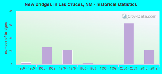
- New bridges - historical statistics
- 31950-1959
- 261960-1969
- 221970-1979
- 21980-1989
- 11990-1999
- 622000-2009
- 222010-2019

- Reconstructed bridges - Historical Statistics
- 11980-1989
- 31990-1999
- 32000-2009
- 32010-2019


- Bridge Condition - Deck
- 79.3%Good
- 19.0%Satisfactory
- 1.7%Fair

- Bridge Condition - Superstructure
- 65.5%Good
- 25.9%Satisfactory
- 3.4%Fair
- 5.2%Poor

- Bridge Condition - Substructure
- 63.8%Good
- 22.4%Satisfactory
- 8.6%Fair
- 5.2%Poor

- Bridge Condition - Channel
- 2.8%Very good
- 36.1%Good
- 19.4%Satisfactory
- 33.3%Fair
- 5.6%Poor
- 2.8%Serious

- Bridge Condition - Culverts
- 40.0%Good
- 40.0%Satisfactory
- 20.0%Fair
Find on map >> Show street view
Structure Number: 5258, Location: 17.1 MI NW OF JCT LOOP-36 (Lat: 35.309347, Lng: -103.957892), Route carried "on" structure: State highway 104, Year Built: 1952, Status: Open, Structure Length: 0.79m (2.59ft), Average Daily Traffic: 214 (year 2020), Truck Traffic: 20%, Average Future Daily Traffic: 184 (year 2040), Design Load: H 15, Features Intersected: UNNAMED WATERWAY
Minimum Vertical Clearance: 30+ m (98+ ft), Kilometerpoint: 144.147, Lanes on structure: 2, Owner: State Highway Agency, Approaching Roadway Width: 7.3m (24.0ft), Skew: 4 degrees, Material/Design: Wood or Timber, Design/Construction: Stringer/Multi-beam, Number Of Spans In Main Unit: 1, Length of Maximum Span: 7.3m (24.0ft), Curb-To-Curb Width: 11.1m (36.4ft), Out-to-Out Width: 11.4m (37.4ft)
Condition: Deck: Fair, Superstructure: Fair, Substructure: Poor, Channel: Satisfactory, Operating Rating: 37.3 metric tons, Method Used To Determine Operating Rating: Allowable Stress (AS), Inventory Rating: 27.5 metric tons, Method Used To Determine Inventory Rating: Allowable Stress (AS), Structural Evaluation: Meets minimum limits, Deck Geometry: Superior to present desirable criteria, Waterway Adequacy: Equal to present desirable criteria, Approach Roadway Alignment: Better than present minimum criteria, Length Of Structure Improvement: 0.79m (2.59ft), Designated Inspection Frequency: Every 6 months, Inspection Date: November 2021, Bridge Improvement Cost: $100,000, Roadway Improvement Cost: $130,000, Total Project Cost: $270,000 ( Estimate for 2030), Deck Structure Type: Wood or Timber, Wearing Surface/Protective System: Wearing Surface: Bituminous
Find on map >> Show street view
Structure Number: 5723, Location: 1.6 MI E OF NM-185/CRUCES (Lat: 32.337525, Lng: -106.778067), Route carried "on" structure: US 70, Year Built: 1957, Status: Open, Structure Length: 6.18m (20.28ft), Average Daily Traffic: 18,554 (year 2020), Truck Traffic: 7%, Average Future Daily Traffic: 26,110 (year 2040), Design Load: HS 20, Features Intersected: ALAMEDA ARROYO
Minimum Vertical Clearance: 30+ m (98+ ft), Kilometerpoint: 240.613, Lanes on structure: 2, Base Highway Network: Yes, Owner: State Highway Agency, Approaching Roadway Width: 8.5m (27.9ft), Skew: 4 degrees, Material/Design: Concrete continuous, Design/Construction: Slab, Number Of Spans In Main Unit: 6, Length of Maximum Span: 10.2m (33.5ft), Curb-To-Curb Width: 8.6m (28.2ft), Out-to-Out Width: 9.7m (31.8ft)
Condition: Deck: Satisfactory, Superstructure: Satisfactory, Substructure: Poor, Channel: Fair, Operating Rating: 55.1 metric tons, Method Used To Determine Operating Rating: Load Factor (LF), Inventory Rating: 33.0 metric tons, Method Used To Determine Inventory Rating: Load Factor (LF), Structural Evaluation: Meets minimum limits, Deck Geometry: High priority of corrective action, Waterway Adequacy: Equal to present desirable criteria, Approach Roadway Alignment: Equal to present desirable criteria, Length Of Structure Improvement: 6.19m (20.31ft), Designated Inspection Frequency: Every 12 months, Inspection Date: August 2021, Bridge Improvement Cost: $316,000, Roadway Improvement Cost: $31,000, Total Project Cost: $474,000, Deck Structure Type: Concrete Cast-file-Place
Find on map >> Show street view
Structure Number: 5724, Location: 1.6 M E NM-185/LAS CRUCES (Lat: 32.337525, Lng: -106.778264), Route carried "on" structure: US 70, Year Built: 1957, Status: Open, Structure Length: 6.18m (20.28ft), Average Daily Traffic: 18,554 (year 2020), Truck Traffic: 7%, Average Future Daily Traffic: 26,110 (year 2040), Design Load: HS 20, Features Intersected: ALAMEDA ARROYO
Minimum Vertical Clearance: 30+ m (98+ ft), Kilometerpoint: 240.613, Lanes on structure: 2, Base Highway Network: Yes, Owner: State Highway Agency, Approaching Roadway Width: 8.5m (27.9ft), Skew: 4 degrees, Material/Design: Concrete continuous, Design/Construction: Slab, Number Of Spans In Main Unit: 6, Length of Maximum Span: 10.2m (33.5ft), Curb or Sidewalk Widths: Left: 0.6m (2.0ft), Right: 0.6m (2.0ft), Curb-To-Curb Width: 8.5m (27.9ft), Out-to-Out Width: 9.7m (31.8ft)
Condition: Deck: Satisfactory, Superstructure: Satisfactory, Substructure: Fair, Channel: Good, Operating Rating: 55.1 metric tons, Method Used To Determine Operating Rating: Load Factor (LF), Inventory Rating: 33.0 metric tons, Method Used To Determine Inventory Rating: Load Factor (LF), Structural Evaluation: Somewhat better than minimum adequacy, Deck Geometry: High priority of corrective action, Waterway Adequacy: Equal to present desirable criteria, Approach Roadway Alignment: Equal to present desirable criteria, Length Of Structure Improvement: 6.19m (20.31ft), Designated Inspection Frequency: Every 24 months, Inspection Date: August 2021, Bridge Improvement Cost: $316,000, Roadway Improvement Cost: $31,000, Total Project Cost: $474,000, Deck Structure Type: Concrete Cast-file-Place
Find on map >> Show street view
Structure Number: 6134, Location: Junction I-25/US-70 (Lat: 32.348031, Lng: -106.769581), Route carried "on" structure: US 70, Year Built: 1960, Year Reconstructed: 2001, Status: Open, Structure Length: 7.32m (24.02ft), Average Daily Traffic: 18,104 (year 2020), Truck Traffic: 7%, Average Future Daily Traffic: 25,476 (year 2040), Design Load: HS 20, Features Intersected: I-25 NBL/SBL
Minimum Vertical Clearance: 30+ m (98+ ft), Kilometerpoint: 241.884, Lanes on structure: 3, Lanes under structure: 6, Base Highway Network: Yes, Owner: State Highway Agency, Approaching Roadway Width: 32.5m (106.6ft), Skew: 21 degrees, Material/Design: Steel continuous, Design/Construction: Stringer/Multi-beam, Number Of Spans In Main Unit: 4, Length of Maximum Span: 20.4m (66.9ft), Curb-To-Curb Width: 32.3m (106.0ft), Out-to-Out Width: 33.8m (110.9ft)
Condition: Deck: Good, Superstructure: Good, Substructure: Good, Operating Rating: 50.2 metric tons, Method Used To Determine Operating Rating: Load Factor (LF), Inventory Rating: 32.4 metric tons, Method Used To Determine Inventory Rating: Load Factor (LF), Structural Evaluation: Better than present minimum criteria, Deck Geometry: Superior to present desirable criteria, Underclear: High priority of corrective action, Approach Roadway Alignment: Equal to present desirable criteria, Length Of Structure Improvement: 7.32m (24.02ft), Designated Inspection Frequency: Every 24 months, Inspection Date: May 2020, Bridge Improvement Cost: $515,000, Roadway Improvement Cost: $51,000, Total Project Cost: $772,000 ( Estimate for 2020), Deck Structure Type: Concrete Cast-file-Place, Wearing Surface/Protective System: Wearing Surface: Epoxy Overlay, Deck Protection: Epoxy Coated Reinforcing
Find on map >> Show street view
Structure Number: 6183, Location: 0.8 MI N OF US-70 (Lat: 32.358094, Lng: -106.776506), Route carried "on" structure: Interstate 25, Year Built: 1961, Status: Open, Structure Length: 2.24m (7.35ft), Average Daily Traffic: 15,732 (year 2020), Truck Traffic: 13%, Average Future Daily Traffic: 28,991 (year 2040), Design Load: HS 20, Features Intersected: SANDHILL ARROYO
Minimum Vertical Clearance: 30+ m (98+ ft), Kilometerpoint: 11.040, Lanes on structure: 4, Base Highway Network: Yes, Owner: State Highway Agency, Approaching Roadway Width: 23.7m (77.8ft), Skew: 20 degrees, Material/Design: Concrete continuous, Design/Construction: Culvert, Number Of Spans In Main Unit: 7, Length of Maximum Span: 3.0m (9.8ft)
Condition: Channel: Good, Culverts: Fair, Operating Rating: 40.8 metric tons, Method Used To Determine Operating Rating: Load Factor (LF), Inventory Rating: 32.7 metric tons, Method Used To Determine Inventory Rating: Load Factor (LF), Structural Evaluation: Somewhat better than minimum adequacy, Waterway Adequacy: Equal to present desirable criteria, Approach Roadway Alignment: Equal to present desirable criteria, Designated Inspection Frequency: Every 24 months, Inspection Date: May 2021
Find on map >> Show street view
Structure Number: 6194, Location: 0.3 MI S OF US-70 (Lat: 32.344539, Lng: -106.767094), Route carried "on" structure: Interstate 25, Year Built: 1960, Status: Open, Structure Length: 1.64m (5.38ft), Average Daily Traffic: 40,730 (year 2020), Truck Traffic: 13%, Average Future Daily Traffic: 75,059 (year 2040), Design Load: HS 20, Features Intersected: UNNAMED WATERWAY
Minimum Vertical Clearance: 30+ m (98+ ft), Kilometerpoint: 9.270, Lanes on structure: 4, Base Highway Network: Yes, Owner: State Highway Agency, Approaching Roadway Width: 34.8m (114.2ft), Skew: 20 degrees, Material/Design: Concrete continuous, Design/Construction: Culvert, Number Of Spans In Main Unit: 5, Length of Maximum Span: 3.0m (9.8ft)
Condition: Channel: Good, Culverts: Good, Operating Rating: 55.5 metric tons, Method Used To Determine Operating Rating: Load Factor (LF), Inventory Rating: 32.7 metric tons, Method Used To Determine Inventory Rating: Load Factor (LF), Structural Evaluation: Better than present minimum criteria, Waterway Adequacy: Equal to present desirable criteria, Approach Roadway Alignment: Equal to present desirable criteria, Designated Inspection Frequency: Every 24 months, Inspection Date: April 2020
Find on map >> Show street view
Structure Number: 6343, Location: .88 MI W. OF I-25 EXIT 3 (Lat: 32.310125, Lng: -106.759056), Route carried "on" structure: City street 5614, Year Built: 1962, Status: Open, Structure Length: 3.66m (12.01ft), Average Daily Traffic: 17,079 (year 2020), Truck Traffic: 7%, Average Future Daily Traffic: 24,035 (year 2040), Design Load: H 15, Features Intersected: LAS CRUCES ARROYO
Minimum Vertical Clearance: 30+ m (98+ ft), Kilometerpoint: 0.000, Lanes on structure: 4, Base Highway Network: Yes, Owner: City or Municipal Highway Agency, Approaching Roadway Width: 25.4m (83.3ft), Skew: 24 degrees, Material/Design: Concrete continuous, Design/Construction: Culvert, Number Of Spans In Main Unit: 8, Length of Maximum Span: 3.0m (9.8ft), Curb or Sidewalk Widths: Left: 1.5m (4.9ft), Right: 1.7m (5.6ft)
Condition: Channel: Satisfactory, Culverts: Satisfactory, Operating Rating: 45.7 metric tons, Method Used To Determine Operating Rating: Load Factor (LF), Inventory Rating: 32.7 metric tons, Method Used To Determine Inventory Rating: Load Factor (LF), Structural Evaluation: Equal to present minimum criteria, Waterway Adequacy: Equal to present desirable criteria, Approach Roadway Alignment: Equal to present desirable criteria, Designated Inspection Frequency: Every 48 months, Inspection Date: Febuary 2021
Find on map >> Show street view
Structure Number: 6562, Location: 17.1 M E Luna/Dona Ana CL (Lat: 32.262161, Lng: -107.008700), Route carried "on" structure: State highway Z003, Year Built: 1966, Status: Open, Structure Length: 7.74m (25.39ft), Average Daily Traffic: 2,483 (year 2020), Truck Traffic: 16%, Average Future Daily Traffic: 4,645 (year 2040), Design Load: HS 20, Features Intersected: I-10 EBL/WBL @ MP-127
Minimum Vertical Clearance: 30+ m (98+ ft), Kilometerpoint: 0.006, Lanes on structure: 2, Lanes under structure: 4, Owner: State Highway Agency, Approaching Roadway Width: 9.1m (29.9ft), Material/Design: Prestressed concrete, Design/Construction: Stringer/Multi-beam, Number Of Spans In Main Unit: 5, Length of Maximum Span: 18.0m (59.1ft), Curb-To-Curb Width: 8.6m (28.2ft), Out-to-Out Width: 9.4m (30.8ft)
Condition: Deck: Satisfactory, Superstructure: Satisfactory, Substructure: Satisfactory, Operating Rating: 53.9 metric tons, Method Used To Determine Operating Rating: Load Factor (LF), Inventory Rating: 32.7 metric tons, Method Used To Determine Inventory Rating: Load Factor (LF), Structural Evaluation: Equal to present minimum criteria, Deck Geometry: Meets minimum limits, Underclear: High priority of corrective action, Approach Roadway Alignment: Equal to present desirable criteria, Designated Inspection Frequency: Every 24 months, Inspection Date: Febuary 2021, Deck Structure Type: Concrete Cast-file-Place
Find on map >> Show street view
Structure Number: 6662, Location: Jct. US-70 and I-10 (Lat: 32.282153, Lng: -106.882486), Route carried "on" structure: Ramp US 70, Year Built: 1966, Year Reconstructed: 2006, Status: Open, Structure Length: 11.37m (37.30ft), Average Daily Traffic: 1,226 (year 2020), Truck Traffic: 2%, Average Future Daily Traffic: 2,473 (year 2040), Design Load: HS 20, Features Intersected: I-10 EBL/WBL
Minimum Vertical Clearance: 30+ m (98+ ft), Kilometerpoint: 226.918, Lanes on structure: 2, Lanes under structure: 4, Base Highway Network: Yes, Owner: State Highway Agency, Approaching Roadway Width: 9.6m (31.5ft), Skew: 4 degrees, Material/Design: Prestressed concrete, Design/Construction: Stringer/Multi-beam, Number Of Spans In Main Unit: 5, Length of Maximum Span: 25.6m (84.0ft), Curb-To-Curb Width: 9.6m (31.5ft), Out-to-Out Width: 10.4m (34.1ft)
Condition: Deck: Good, Superstructure: Satisfactory, Substructure: Satisfactory, Operating Rating: 56.7 metric tons, Method Used To Determine Operating Rating: Load Factor (LF), Inventory Rating: 32.9 metric tons, Method Used To Determine Inventory Rating: Load Factor (LF), Structural Evaluation: Equal to present minimum criteria, Deck Geometry: Somewhat better than minimum adequacy, Underclear: Meets minimum limits, Approach Roadway Alignment: Equal to present desirable criteria, Length Of Structure Improvement: 11.37m (37.30ft), Designated Inspection Frequency: Every 24 months, Inspection Date: April 2021, Bridge Improvement Cost: $621,000, Roadway Improvement Cost: $62,000, Total Project Cost: $932,000 ( Estimate for 2030), Deck Structure Type: Concrete Cast-file-Place, Wearing Surface/Protective System: Deck Protection: Epoxy Coated Reinforcing
Find on map >> Show street view
Structure Number: 6823, Location: Jct I-25/NM101-University (Lat: 32.286983, Lng: -106.738603), Route carried "on" structure: State highway 101, Year Built: 1968, Year Reconstructed: 1988, Status: Open, Structure Length: 5.30m (17.39ft), Average Daily Traffic: 16,824 (year 2020), Truck Traffic: 7%, Average Future Daily Traffic: 23,676 (year 2040), Design Load: HS 20, Features Intersected: I-25 NBL and SBL
Minimum Vertical Clearance: 30+ m (98+ ft), Kilometerpoint: 5.311, Lanes on structure: 4, Lanes under structure: 4, Base Highway Network: Yes, Owner: State Highway Agency, Approaching Roadway Width: 18.3m (60.0ft), Skew: 20 degrees, Material/Design: Prestressed concrete, Design/Construction: Stringer/Multi-beam, Number Of Spans In Main Unit: 4, Length of Maximum Span: 18.0m (59.1ft), Curb or Sidewalk Widths: Left: 0.0m, Right: 1.4m (4.6ft), Curb-To-Curb Width: 22.6m (74.1ft), Out-to-Out Width: 24.5m (80.4ft)
Condition: Deck: Good, Superstructure: Satisfactory, Substructure: Satisfactory, Operating Rating: 69.7 metric tons, Method Used To Determine Operating Rating: Load Factor (LF), Inventory Rating: 42.1 metric tons, Method Used To Determine Inventory Rating: Load Factor (LF), Structural Evaluation: Equal to present minimum criteria, Deck Geometry: Superior to present desirable criteria, Underclear: Somewhat better than minimum adequacy, Approach Roadway Alignment: Equal to present desirable criteria, Designated Inspection Frequency: Every 24 months, Inspection Date: November 2021, Deck Structure Type: Concrete Cast-file-Place, Wearing Surface/Protective System: Wearing Surface: Latex Concrete
Find on map >> Show street view
Structure Number: 6829, Location: 6.0 M S Jct I-25/ US-70 (Lat: 32.268508, Lng: -106.732500), Route carried "on" structure: Interstate 25, Year Built: 1968, Year Reconstructed: 2013, Status: Open, Structure Length: 2.99m (9.81ft), Average Daily Traffic: 7,877 (year 2020), Truck Traffic: 13%, Average Future Daily Traffic: 14,515 (year 2040), Design Load: HS 20, Features Intersected: Cholla Road
Minimum Vertical Clearance: 30+ m (98+ ft), Kilometerpoint: 0.145, Lanes on structure: 2, Lanes under structure: 2, Base Highway Network: Yes, Owner: State Highway Agency, Approaching Roadway Width: 16.5m (54.1ft), Material/Design: Concrete continuous, Design/Construction: Slab, Number Of Spans In Main Unit: 3, Length of Maximum Span: 11.9m (39.0ft), Curb-To-Curb Width: 16.2m (53.1ft), Out-to-Out Width: 20.7m (67.9ft)
Condition: Deck: Good, Superstructure: Good, Substructure: Good, Operating Rating: 55.9 metric tons, Method Used To Determine Operating Rating: Load Factor (LF), Inventory Rating: 33.5 metric tons, Method Used To Determine Inventory Rating: Load Factor (LF), Structural Evaluation: Better than present minimum criteria, Deck Geometry: Superior to present desirable criteria, Underclear: Meets minimum limits, Approach Roadway Alignment: Equal to present desirable criteria, Designated Inspection Frequency: Every 24 months, Inspection Date: July 2021, Deck Structure Type: Concrete Cast-file-Place
Find on map >> Show street view
Structure Number: 683, Location: 6.0 M S I-25/US-70/CRUCES (Lat: 32.268461, Lng: -106.732719), Route carried "on" structure: Interstate 25, Year Built: 1968, Year Reconstructed: 2013, Status: Open, Structure Length: 2.99m (9.81ft), Average Daily Traffic: 7,877 (year 2020), Truck Traffic: 13%, Average Future Daily Traffic: 14,515 (year 2040), Design Load: HS 20, Features Intersected: Cholla Road
Minimum Vertical Clearance: 30+ m (98+ ft), Kilometerpoint: 0.145, Lanes on structure: 2, Lanes under structure: 2, Base Highway Network: Yes, Owner: State Highway Agency, Approaching Roadway Width: 20.1m (65.9ft), Material/Design: Concrete continuous, Design/Construction: Slab, Number Of Spans In Main Unit: 3, Length of Maximum Span: 11.6m (38.1ft), Curb-To-Curb Width: 20.0m (65.6ft), Out-to-Out Width: 20.7m (67.9ft)
Condition: Deck: Good, Superstructure: Good, Substructure: Good, Operating Rating: 55.5 metric tons, Method Used To Determine Operating Rating: Load Factor (LF), Inventory Rating: 33.1 metric tons, Method Used To Determine Inventory Rating: Load Factor (LF), Structural Evaluation: Better than present minimum criteria, Deck Geometry: Superior to present desirable criteria, Underclear: Meets minimum limits, Approach Roadway Alignment: Equal to present desirable criteria, Designated Inspection Frequency: Every 24 months, Inspection Date: July 2021, Deck Structure Type: Concrete Cast-file-Place
Find on map >> Show street view
Structure Number: 6831, Location: 1.6 M W Jct I-10 & I-25 (Lat: 32.265422, Lng: -106.738642), Route carried "on" structure: Interstate 10, Year Built: 1968, Status: Open, Structure Length: 2.93m (9.61ft), Average Daily Traffic: 17,333 (year 2020), Truck Traffic: 13%, Average Future Daily Traffic: 31,941 (year 2040), Design Load: HS 20, Features Intersected: Cholla Road
Minimum Vertical Clearance: 30+ m (98+ ft), Kilometerpoint: 231.247, Lanes on structure: 2, Lanes under structure: 2, Base Highway Network: Yes, Owner: State Highway Agency, Approaching Roadway Width: 11.6m (38.1ft), Material/Design: Concrete continuous, Design/Construction: Slab, Number Of Spans In Main Unit: 3, Length of Maximum Span: 11.7m (38.4ft), Curb-To-Curb Width: 11.7m (38.4ft), Out-to-Out Width: 12.5m (41.0ft)
Condition: Deck: Satisfactory, Superstructure: Satisfactory, Substructure: Satisfactory, Operating Rating: 61.4 metric tons, Method Used To Determine Operating Rating: Load Factor (LF), Inventory Rating: 36.7 metric tons, Method Used To Determine Inventory Rating: Load Factor (LF), Structural Evaluation: Equal to present minimum criteria, Deck Geometry: Equal to present minimum criteria, Underclear: Meets minimum limits, Approach Roadway Alignment: Equal to present desirable criteria, Designated Inspection Frequency: Every 24 months, Inspection Date: September 2020, Deck Structure Type: Concrete Cast-file-Place
Find on map >> Show street view
Structure Number: 6832, Location: 1.6 M W Jct I-10 & I-25 (Lat: 32.265575, Lng: -106.738528), Route carried "on" structure: Interstate 10, Year Built: 1968, Status: Open, Structure Length: 2.99m (9.81ft), Average Daily Traffic: 17,333 (year 2020), Truck Traffic: 13%, Average Future Daily Traffic: 31,941 (year 2040), Design Load: HS 20, Features Intersected: Cholla Road
Minimum Vertical Clearance: 30+ m (98+ ft), Kilometerpoint: 231.247, Lanes on structure: 2, Lanes under structure: 2, Base Highway Network: Yes, Owner: State Highway Agency, Approaching Roadway Width: 11.6m (38.1ft), Material/Design: Concrete continuous, Design/Construction: Slab, Number Of Spans In Main Unit: 3, Length of Maximum Span: 11.6m (38.1ft), Curb-To-Curb Width: 11.6m (38.1ft), Out-to-Out Width: 12.5m (41.0ft)
Condition: Deck: Satisfactory, Superstructure: Satisfactory, Substructure: Satisfactory, Operating Rating: 61.4 metric tons, Method Used To Determine Operating Rating: Load Factor (LF), Inventory Rating: 36.7 metric tons, Method Used To Determine Inventory Rating: Load Factor (LF), Structural Evaluation: Equal to present minimum criteria, Deck Geometry: Equal to present minimum criteria, Underclear: High priority of corrective action, Approach Roadway Alignment: Equal to present desirable criteria, Designated Inspection Frequency: Every 24 months, Inspection Date: September 2020, Deck Structure Type: Concrete Cast-file-Place
Find on map >> Show street view
Structure Number: 6833, Location: 1.0 MI S OF JCT I-10/I-25 (Lat: 32.244594, Lng: -106.721269), Route carried "on" structure: State highway 1035, Year Built: 1968, Status: Open, Structure Length: 6.61m (21.69ft), Average Daily Traffic: 3,282 (year 2020), Truck Traffic: 16%, Average Future Daily Traffic: 6,139 (year 2040), Design Load: HS 20, Features Intersected: FILLMORE ARROYO
Minimum Vertical Clearance: 30+ m (98+ ft), Kilometerpoint: 234.143, Lanes on structure: 2, Owner: State Highway Agency, Approaching Roadway Width: 9.6m (31.5ft), Material/Design: Concrete continuous, Design/Construction: Slab, Number Of Spans In Main Unit: 9, Length of Maximum Span: 7.6m (24.9ft), Curb-To-Curb Width: 9.8m (32.2ft), Out-to-Out Width: 10.7m (35.1ft)
Condition: Deck: Satisfactory, Superstructure: Satisfactory, Substructure: Satisfactory, Channel: Satisfactory, Operating Rating: 59.6 metric tons, Method Used To Determine Operating Rating: Load Factor (LF), Inventory Rating: 35.6 metric tons, Method Used To Determine Inventory Rating: Load Factor (LF), Structural Evaluation: Equal to present minimum criteria, Deck Geometry: Meets minimum limits, Waterway Adequacy: Better than present minimum criteria, Approach Roadway Alignment: Equal to present desirable criteria, Designated Inspection Frequency: Every 24 months, Inspection Date: March 2020, Deck Structure Type: Concrete Cast-file-Place
Find on map >> Show street view
Structure Number: 6969, Location: 0.2 MI S JCT I-10/I-25 (Lat: 32.255361, Lng: -106.730739), Route carried "on" structure: State highway 1035, Year Built: 1968, Status: Open, Structure Length: 1.58m (5.18ft), Average Daily Traffic: 3,282 (year 2020), Truck Traffic: 16%, Average Future Daily Traffic: 6,139 (year 2040), Design Load: HS 20, Features Intersected: UNNAMED WATERWAY
Minimum Vertical Clearance: 99.90m (327.76ft), Kilometerpoint: 4.007, Lanes on structure: 2, Owner: State Highway Agency, Approaching Roadway Width: 12.2m (40.0ft), Material/Design: Concrete continuous, Design/Construction: Culvert, Number Of Spans In Main Unit: 5, Length of Maximum Span: 3.0m (9.8ft)
Condition: Channel: Poor, Culverts: Good, Operating Rating: 45.7 metric tons, Method Used To Determine Operating Rating: Load Factor (LF), Inventory Rating: 32.7 metric tons, Method Used To Determine Inventory Rating: Load Factor (LF), Structural Evaluation: Better than present minimum criteria, Waterway Adequacy: Equal to present desirable criteria, Approach Roadway Alignment: Equal to present desirable criteria, Designated Inspection Frequency: Every 24 months, Inspection Date: August 2020
Find on map >> Show street view
Structure Number: 697, Location: 0.8 MI S JCT I-25/I-10 (Lat: 32.255436, Lng: -106.730439), Route carried "on" structure: Interstate 1144, Year Built: 1968, Status: Open, Structure Length: 1.58m (5.18ft), Average Daily Traffic: 7,877 (year 2020), Truck Traffic: 13%, Average Future Daily Traffic: 14,515 (year 2040), Design Load: HS 20, Features Intersected: UNNAMED WATERWAY
Minimum Vertical Clearance: 99.00m (324.80ft), Kilometerpoint: 0.000, Lanes on structure: 3, Base Highway Network: Yes, Owner: State Highway Agency, Approaching Roadway Width: 19.0m (62.3ft), Skew: 31 degrees, Material/Design: Concrete continuous, Design/Construction: Culvert, Number Of Spans In Main Unit: 5, Length of Maximum Span: 3.0m (9.8ft), Curb-To-Curb Width: 19.0m (62.3ft), Out-to-Out Width: 19.2m (63.0ft)
Condition: Channel: Good, Culverts: Satisfactory, Operating Rating: 55.5 metric tons, Method Used To Determine Operating Rating: Load Factor (LF), Inventory Rating: 32.7 metric tons, Method Used To Determine Inventory Rating: Load Factor (LF), Structural Evaluation: Equal to present minimum criteria, Deck Geometry: Superior to present desirable criteria, Waterway Adequacy: Equal to present desirable criteria, Approach Roadway Alignment: Equal to present desirable criteria, Designated Inspection Frequency: Every 24 months, Inspection Date: January 2021
Find on map >> Show street view
Structure Number: 6971, Location: 0.2 MI S JCT I-10/I-25 (Lat: 32.256172, Lng: -106.729194), Route carried "on" structure: Interstate 10, Year Built: 1968, Status: Open, Structure Length: 1.62m (5.31ft), Average Daily Traffic: 26,836 (year 2020), Truck Traffic: 13%, Average Future Daily Traffic: 49,454 (year 2040), Design Load: HS 20, Features Intersected: UNNAMED WATERWAY
Minimum Vertical Clearance: 99.90m (327.76ft), Kilometerpoint: 232.646, Lanes on structure: 2, Base Highway Network: Yes, Owner: State Highway Agency, Approaching Roadway Width: 10.1m (33.1ft), Skew: 1 degrees, Material/Design: Concrete continuous, Design/Construction: Culvert, Number Of Spans In Main Unit: 5, Length of Maximum Span: 3.0m (9.8ft)
Condition: Channel: Satisfactory, Culverts: Satisfactory, Operating Rating: 47.4 metric tons, Method Used To Determine Operating Rating: Load Factor (LF), Inventory Rating: 32.7 metric tons, Method Used To Determine Inventory Rating: Load Factor (LF), Structural Evaluation: Equal to present minimum criteria, Waterway Adequacy: Equal to present desirable criteria, Approach Roadway Alignment: Equal to present desirable criteria, Designated Inspection Frequency: Every 24 months, Inspection Date: January 2021
Find on map >> Show street view
Structure Number: 6973, Location: 5.9 MI S OF US-70 (Lat: 32.268819, Lng: -106.732600), Route carried "on" structure: Interstate 25, Year Built: 1968, Status: Open, Structure Length: 0.62m (2.03ft), Average Daily Traffic: 7,877 (year 2020), Truck Traffic: 13%, Average Future Daily Traffic: 14,515 (year 2040), Design Load: HS 20, Features Intersected: UNNAMED WATERWAY
Minimum Vertical Clearance: 30+ m (98+ ft), Kilometerpoint: 0.177, Lanes on structure: 4, Base Highway Network: Yes, Owner: State Highway Agency, Approaching Roadway Width: 22.9m (75.1ft), Skew: 20 degrees, Material/Design: Concrete continuous, Design/Construction: Culvert, Number Of Spans In Main Unit: 2, Length of Maximum Span: 3.0m (9.8ft)
Condition: Channel: Good, Culverts: Satisfactory, Operating Rating: 98.0 metric tons, Method Used To Determine Operating Rating: Load Factor (LF), Inventory Rating: 32.7 metric tons, Method Used To Determine Inventory Rating: Load Factor (LF), Structural Evaluation: Equal to present minimum criteria, Waterway Adequacy: Equal to present desirable criteria, Approach Roadway Alignment: Equal to present desirable criteria, Designated Inspection Frequency: Every 24 months, Inspection Date: May 2021
Find on map >> Show street view
Structure Number: 6974, Location: 5.9 MI S OF US-70 (Lat: 32.273769, Lng: -106.733978), Route carried "on" structure: State highway 13003, Year Built: 1968, Status: Open, Structure Length: 0.62m (2.03ft), Average Daily Traffic: 4,393 (year 2018), Truck Traffic: 3%, Average Future Daily Traffic: 5,801 (year 2038), Design Load: HS 20, Features Intersected: UNNAMED WWAY I25 MP142.7, Facility Carried by Structure: 13-Z003
Minimum Vertical Clearance: 30+ m (98+ ft), Kilometerpoint: 0.000, Lanes on structure: 2, Owner: State Highway Agency, Approaching Roadway Width: 27.2m (89.2ft), Material/Design: Concrete continuous, Design/Construction: Culvert, Number Of Spans In Main Unit: 2, Length of Maximum Span: 3.0m (9.8ft)
Condition: Channel: Fair, Culverts: Satisfactory, Operating Rating: 37.6 metric tons, Method Used To Determine Operating Rating: Load Factor (LF), Inventory Rating: 32.7 metric tons, Method Used To Determine Inventory Rating: Load Factor (LF), Structural Evaluation: Equal to present minimum criteria, Waterway Adequacy: Better than present minimum criteria, Approach Roadway Alignment: Equal to present desirable criteria, Designated Inspection Frequency: Every 24 months, Inspection Date: May 2021
Find on map >> Show street view
Structure Number: 6975, Location: 5.1 MI S OF US-70 (Lat: 32.281039, Lng: -106.736558), Route carried "on" structure: Interstate 25, Year Built: 1968, Status: Open, Structure Length: 2.71m (8.89ft), Average Daily Traffic: 7,877 (year 2020), Truck Traffic: 13%, Average Future Daily Traffic: 14,515 (year 2040), Design Load: HS 20, Features Intersected: UNNAMED WATERWAY
Minimum Vertical Clearance: 30+ m (98+ ft), Kilometerpoint: 1.577, Lanes on structure: 4, Base Highway Network: Yes, Owner: State Highway Agency, Approaching Roadway Width: 39.6m (129.9ft), Skew: 21 degrees, Material/Design: Concrete continuous, Design/Construction: Culvert, Number Of Spans In Main Unit: 8, Length of Maximum Span: 3.0m (9.8ft)
Condition: Channel: Good, Culverts: Satisfactory, Operating Rating: 50.6 metric tons, Method Used To Determine Operating Rating: Load Factor (LF), Inventory Rating: 32.7 metric tons, Method Used To Determine Inventory Rating: Load Factor (LF), Structural Evaluation: Equal to present minimum criteria, Waterway Adequacy: Equal to present desirable criteria, Approach Roadway Alignment: Equal to present desirable criteria, Designated Inspection Frequency: Every 24 months, Inspection Date: May 2021
Find on map >> Show street view
Structure Number: 7169, Location: 2.4 Mi E of I-10 Exit-135 (Lat: 32.286233, Lng: -106.843336), Route carried "on" structure: Interstate 10, Year Built: 1971, Status: Open, Structure Length: 4.42m (14.50ft), Average Daily Traffic: 19,232 (year 2020), Truck Traffic: 13%, Average Future Daily Traffic: 35,441 (year 2040), Design Load: HS 20, Features Intersected: Local Road (NM 359)
Minimum Vertical Clearance: 30+ m (98+ ft), Kilometerpoint: 220.400, Lanes on structure: 2, Lanes under structure: 2, Base Highway Network: Yes, Owner: State Highway Agency, Approaching Roadway Width: 12.5m (41.0ft), Skew: 3 degrees, Material/Design: Prestressed concrete, Design/Construction: Stringer/Multi-beam, Number Of Spans In Main Unit: 3, Length of Maximum Span: 19.5m (64.0ft), Curb-To-Curb Width: 12.8m (42.0ft), Out-to-Out Width: 13.7m (44.9ft)
Condition: Deck: Good, Superstructure: Satisfactory, Substructure: Satisfactory, Operating Rating: 53.9 metric tons, Method Used To Determine Operating Rating: Load Factor (LF), Inventory Rating: 32.7 metric tons, Method Used To Determine Inventory Rating: Load Factor (LF), Structural Evaluation: Equal to present minimum criteria, Deck Geometry: Equal to present desirable criteria, Underclear: Equal to present minimum criteria, Approach Roadway Alignment: Equal to present desirable criteria, Designated Inspection Frequency: Every 24 months, Inspection Date: March 2021, Deck Structure Type: Concrete Cast-file-Place
Find on map >> Show street view
Structure Number: 717, Location: 2.4 Mi E of I-10 Exit-135 (Lat: 32.286436, Lng: -106.843261), Route carried "on" structure: Interstate 10, Year Built: 1971, Status: Open, Structure Length: 4.42m (14.50ft), Average Daily Traffic: 19,232 (year 2020), Truck Traffic: 13%, Average Future Daily Traffic: 35,441 (year 2040), Design Load: HS 20, Features Intersected: Local Road
Minimum Vertical Clearance: 30+ m (98+ ft), Kilometerpoint: 220.400, Lanes on structure: 2, Lanes under structure: 2, Base Highway Network: Yes, Owner: State Highway Agency, Approaching Roadway Width: 12.6m (41.3ft), Skew: 3 degrees, Material/Design: Prestressed concrete, Design/Construction: Stringer/Multi-beam, Number Of Spans In Main Unit: 3, Length of Maximum Span: 19.4m (63.6ft), Curb-To-Curb Width: 12.8m (42.0ft), Out-to-Out Width: 13.7m (44.9ft)
Condition: Deck: Satisfactory, Superstructure: Fair, Substructure: Good, Operating Rating: 53.9 metric tons, Method Used To Determine Operating Rating: Load Factor (LF), Inventory Rating: 32.7 metric tons, Method Used To Determine Inventory Rating: Load Factor (LF), Structural Evaluation: Somewhat better than minimum adequacy, Deck Geometry: Equal to present desirable criteria, Underclear: Equal to present minimum criteria, Approach Roadway Alignment: Equal to present desirable criteria, Designated Inspection Frequency: Every 24 months, Inspection Date: March 2021, Deck Structure Type: Concrete Cast-file-Place
Find on map >> Show street view
Structure Number: 7171, Location: 3.5 Mi E of I-10 Exit-135 (Lat: 32.290431, Lng: -106.825106), Route carried "on" structure: Interstate 10, Year Built: 1971, Year Reconstructed: 2002, Status: Open, Structure Length: 29.99m (98.39ft), Average Daily Traffic: 19,232 (year 2020), Truck Traffic: 13%, Average Future Daily Traffic: 35,441 (year 2040), Design Load: HS 20, Features Intersected: Rio Grande & Local Road
Minimum Vertical Clearance: 30+ m (98+ ft), Kilometerpoint: 222.186, Lanes on structure: 2, Lanes under structure: 2, Base Highway Network: Yes, Owner: State Highway Agency, Approaching Roadway Width: 13.0m (42.7ft), Skew: 2 degrees, Material/Design: Prestressed concrete, Design/Construction: Stringer/Multi-beam, Number Of Spans In Main Unit: 12, Length of Maximum Span: 24.5m (80.4ft), Curb-To-Curb Width: 12.8m (42.0ft), Out-to-Out Width: 13.7m (44.9ft)
Condition: Deck: Good, Superstructure: Good, Substructure: Fair, Channel: Good, Operating Rating: 52.3 metric tons, Method Used To Determine Operating Rating: Load Factor (LF), Inventory Rating: 32.7 metric tons, Method Used To Determine Inventory Rating: Load Factor (LF), Structural Evaluation: Somewhat better than minimum adequacy, Deck Geometry: Equal to present desirable criteria, Underclear: Superior to present desirable criteria, Waterway Adequacy: Equal to present minimum criteria, Approach Roadway Alignment: Equal to present desirable criteria, Designated Inspection Frequency: Every 24 months, Inspection Date: November 2021, Deck Structure Type: Concrete Cast-file-Place, Wearing Surface/Protective System: Deck Protection: Epoxy Coated Reinforcing
Find on map >> Show street view
Structure Number: 7172, Location: 3.5 Mi E I-10 Exit-135 (Lat: 32.290650, Lng: -106.825097), Route carried "on" structure: Interstate 10, Year Built: 1971, Year Reconstructed: 2002, Status: Open, Structure Length: 29.99m (98.39ft), Average Daily Traffic: 19,232 (year 2020), Truck Traffic: 13%, Average Future Daily Traffic: 35,441 (year 2040), Design Load: HS 20, Features Intersected: Rio Grande/Local Rd
Minimum Vertical Clearance: 30+ m (98+ ft), Kilometerpoint: 222.186, Lanes on structure: 2, Lanes under structure: 2, Base Highway Network: Yes, Owner: State Highway Agency, Approaching Roadway Width: 13.2m (43.3ft), Skew: 2 degrees, Material/Design: Prestressed concrete, Design/Construction: Stringer/Multi-beam, Number Of Spans In Main Unit: 12, Length of Maximum Span: 24.7m (81.0ft), Curb-To-Curb Width: 12.8m (42.0ft), Out-to-Out Width: 13.7m (44.9ft)
Condition: Deck: Good, Superstructure: Good, Substructure: Fair, Channel: Good, Operating Rating: 52.3 metric tons, Method Used To Determine Operating Rating: Load Factor (LF), Inventory Rating: 32.7 metric tons, Method Used To Determine Inventory Rating: Load Factor (LF), Structural Evaluation: Somewhat better than minimum adequacy, Deck Geometry: Equal to present desirable criteria, Waterway Adequacy: Equal to present minimum criteria, Approach Roadway Alignment: Equal to present desirable criteria, Designated Inspection Frequency: Every 24 months, Inspection Date: November 2021, Deck Structure Type: Concrete Cast-file-Place, Wearing Surface/Protective System: Deck Protection: Epoxy Coated Reinforcing
Find on map >> Show street view
Structure Number: 7264, Location: 7.4 Mi E of I-10 Exit-135 (Lat: 32.279189, Lng: -106.765753), Route carried "on" structure: Interstate 10, Year Built: 1971, Status: Open, Structure Length: 5.99m (19.65ft), Average Daily Traffic: 25,615 (year 2020), Truck Traffic: 13%, Average Future Daily Traffic: 47,204 (year 2040), Design Load: HS 20, Features Intersected: IG 1142 Ramp 'E'
Minimum Vertical Clearance: 30+ m (98+ ft), Kilometerpoint: 228.237, Lanes on structure: 2, Lanes under structure: 1, Base Highway Network: Yes, Owner: State Highway Agency, Approaching Roadway Width: 12.9m (42.3ft), Skew: 5 degrees, Material/Design: Prestressed concrete, Design/Construction: Stringer/Multi-beam, Number Of Spans In Main Unit: 3, Length of Maximum Span: 25.3m (83.0ft), Curb-To-Curb Width: 12.8m (42.0ft), Out-to-Out Width: 13.7m (44.9ft)
Condition: Deck: Good, Superstructure: Good, Substructure: Good, Operating Rating: 68.9 metric tons, Method Used To Determine Operating Rating: Load Factor (LF), Inventory Rating: 42.0 metric tons, Method Used To Determine Inventory Rating: Load Factor (LF), Structural Evaluation: Better than present minimum criteria, Deck Geometry: Equal to present desirable criteria, Underclear: Somewhat better than minimum adequacy, Approach Roadway Alignment: Equal to present desirable criteria, Designated Inspection Frequency: Every 24 months, Inspection Date: September 2020, Deck Structure Type: Concrete Cast-file-Place, Wearing Surface/Protective System: Deck Protection: Epoxy Coated Reinforcing
Find on map >> Show street view
Structure Number: 7265, Location: 7.4 Mi E of I-10 Exit-135 (Lat: 32.279478, Lng: -106.765900), Route carried "on" structure: Interstate 10, Year Built: 1971, Year Reconstructed: 2016, Status: Open, Structure Length: 5.99m (19.65ft), Average Daily Traffic: 25,615 (year 2020), Truck Traffic: 13%, Average Future Daily Traffic: 47,204 (year 2040), Design Load: HS 20, Features Intersected: Ramp E of I-10
Minimum Vertical Clearance: 30+ m (98+ ft), Kilometerpoint: 228.237, Lanes on structure: 2, Lanes under structure: 1, Base Highway Network: Yes, Owner: State Highway Agency, Approaching Roadway Width: 13.0m (42.7ft), Skew: 5 degrees, Material/Design: Prestressed concrete, Design/Construction: Stringer/Multi-beam, Number Of Spans In Main Unit: 3, Length of Maximum Span: 25.3m (83.0ft), Curb-To-Curb Width: 8.0m (26.2ft), Out-to-Out Width: 13.7m (44.9ft)
Condition: Deck: Good, Superstructure: Good, Substructure: Satisfactory, Operating Rating: 68.9 metric tons, Method Used To Determine Operating Rating: Load Factor (LF), Inventory Rating: 42.0 metric tons, Method Used To Determine Inventory Rating: Load Factor (LF), Structural Evaluation: Equal to present minimum criteria, Deck Geometry: High priority of replacement, Underclear: Equal to present minimum criteria, Approach Roadway Alignment: Equal to present desirable criteria, Designated Inspection Frequency: Every 24 months, Inspection Date: September 2020, Deck Structure Type: Concrete Cast-file-Place, Wearing Surface/Protective System: Deck Protection: Epoxy Coated Reinforcing
Find on map >> Show street view
Structure Number: 7266, Location: 1.8 M E Jct I-10/NM-26 (Lat: 32.277239, Lng: -106.761900), Route carried "on" structure: Interstate 10, Year Built: 1971, Year Reconstructed: 2016, Status: Open, Structure Length: 5.40m (17.72ft), Average Daily Traffic: 17,333 (year 2020), Truck Traffic: 13%, Average Future Daily Traffic: 31,941 (year 2040), Design Load: HS 20, Features Intersected: UNION AVENUE
Minimum Vertical Clearance: 30+ m (98+ ft), Kilometerpoint: 228.704, Lanes on structure: 2, Lanes under structure: 4, Base Highway Network: Yes, Owner: State Highway Agency, Approaching Roadway Width: 19.1m (62.7ft), Material/Design: Prestressed concrete, Design/Construction: Stringer/Multi-beam, Number Of Spans In Main Unit: 3, Length of Maximum Span: 26.3m (86.3ft), Curb-To-Curb Width: 18.3m (60.0ft), Out-to-Out Width: 18.3m (60.0ft)
Condition: Deck: Good, Superstructure: Good, Substructure: Good, Operating Rating: 72.7 metric tons, Method Used To Determine Operating Rating: Load Factor (LF), Inventory Rating: 42.4 metric tons, Method Used To Determine Inventory Rating: Load Factor (LF), Structural Evaluation: Better than present minimum criteria, Deck Geometry: Superior to present desirable criteria, Underclear: Meets minimum limits, Approach Roadway Alignment: Equal to present desirable criteria, Designated Inspection Frequency: Every 24 months, Inspection Date: July 2020, Deck Structure Type: Concrete Cast-file-Place, Wearing Surface/Protective System: Deck Protection: Epoxy Coated Reinforcing
Find on map >> Show street view
Structure Number: 7267, Location: 1.8 M E Jct I_10/NM-26 (Lat: 32.277389, Lng: -106.761792), Route carried "on" structure: Interstate 10, Year Built: 1971, Year Reconstructed: 2016, Status: Open, Structure Length: 5.40m (17.72ft), Average Daily Traffic: 17,333 (year 2020), Truck Traffic: 13%, Average Future Daily Traffic: 31,941 (year 2040), Design Load: HS 20, Features Intersected: E. UNION AVENUE
Minimum Vertical Clearance: 30+ m (98+ ft), Kilometerpoint: 228.704, Lanes on structure: 2, Lanes under structure: 5, Base Highway Network: Yes, Owner: State Highway Agency, Approaching Roadway Width: 13.0m (42.7ft), Material/Design: Prestressed concrete, Design/Construction: Stringer/Multi-beam, Number Of Spans In Main Unit: 3, Length of Maximum Span: 26.3m (86.3ft), Curb-To-Curb Width: 7.4m (24.3ft), Out-to-Out Width: 13.7m (44.9ft)
Condition: Deck: Good, Superstructure: Good, Substructure: Good, Operating Rating: 70.6 metric tons, Method Used To Determine Operating Rating: Load Factor (LF), Inventory Rating: 41.6 metric tons, Method Used To Determine Inventory Rating: Load Factor (LF), Structural Evaluation: Better than present minimum criteria, Deck Geometry: High priority of replacement, Underclear: Meets minimum limits, Approach Roadway Alignment: Equal to present desirable criteria, Designated Inspection Frequency: Every 24 months, Inspection Date: July 2020, Deck Structure Type: Concrete Cast-file-Place, Wearing Surface/Protective System: Deck Protection: Epoxy Coated Reinforcing
Find on map >> Show street view
Structure Number: 7268, Location: 8.8 Mi E of I-10 Exit 135 (Lat: 32.268967, Lng: -106.745628), Route carried "on" structure: Interstate 10, Year Built: 1972, Status: Open, Structure Length: 5.09m (16.70ft), Average Daily Traffic: 17,333 (year 2020), Truck Traffic: 13%, Average Future Daily Traffic: 31,941 (year 2040), Design Load: HS 20, Features Intersected: Tortugas Arroyo
Minimum Vertical Clearance: 30+ m (98+ ft), Kilometerpoint: 230.474, Lanes on structure: 2, Base Highway Network: Yes, Owner: State Highway Agency, Approaching Roadway Width: 12.7m (41.7ft), Material/Design: Concrete continuous, Design/Construction: Slab, Number Of Spans In Main Unit: 7, Length of Maximum Span: 7.6m (24.9ft), Curb-To-Curb Width: 12.8m (42.0ft), Out-to-Out Width: 13.7m (44.9ft)
Condition: Deck: Satisfactory, Superstructure: Satisfactory, Substructure: Satisfactory, Channel: Good, Operating Rating: 58.2 metric tons, Method Used To Determine Operating Rating: Load Factor (LF), Inventory Rating: 34.7 metric tons, Method Used To Determine Inventory Rating: Load Factor (LF), Structural Evaluation: Equal to present minimum criteria, Deck Geometry: Equal to present desirable criteria, Waterway Adequacy: Equal to present minimum criteria, Approach Roadway Alignment: Equal to present desirable criteria, Designated Inspection Frequency: Every 24 months, Inspection Date: August 2020, Deck Structure Type: Concrete Cast-file-Place, Wearing Surface/Protective System: Deck Protection: Epoxy Coated Reinforcing
Find on map >> Show street view
Structure Number: 7269, Location: 8.8 Mi E of I-10 Exit 135 (Lat: 32.269128, Lng: -106.745528), Route carried "on" structure: Interstate 10, Year Built: 1972, Status: Open, Structure Length: 5.12m (16.80ft), Average Daily Traffic: 17,333 (year 2020), Truck Traffic: 13%, Average Future Daily Traffic: 31,941 (year 2040), Design Load: HS 20, Features Intersected: Tortugas Arroyo
Minimum Vertical Clearance: 30+ m (98+ ft), Kilometerpoint: 230.474, Lanes on structure: 2, Base Highway Network: Yes, Owner: State Highway Agency, Approaching Roadway Width: 12.7m (41.7ft), Material/Design: Concrete continuous, Design/Construction: Slab, Number Of Spans In Main Unit: 7, Length of Maximum Span: 7.6m (24.9ft), Curb-To-Curb Width: 12.9m (42.3ft), Out-to-Out Width: 13.6m (44.6ft)
Condition: Deck: Satisfactory, Superstructure: Satisfactory, Substructure: Fair, Channel: Good, Operating Rating: 58.2 metric tons, Method Used To Determine Operating Rating: Load Factor (LF), Inventory Rating: 34.7 metric tons, Method Used To Determine Inventory Rating: Load Factor (LF), Structural Evaluation: Somewhat better than minimum adequacy, Deck Geometry: Superior to present desirable criteria, Waterway Adequacy: Equal to present minimum criteria, Approach Roadway Alignment: Equal to present desirable criteria, Designated Inspection Frequency: Every 24 months, Inspection Date: August 2020, Deck Structure Type: Concrete Cast-file-Place
Find on map >> Show street view
Structure Number: 727, Location: 8.8 MI E OF I-10 EXIT 135 (Lat: 32.268800, Lng: -106.745800), Route carried "on" structure: State highway 1035, Year Built: 1972, Status: Open, Structure Length: 5.07m (16.63ft), Average Daily Traffic: 3,510 (year 2020), Truck Traffic: 7%, Average Future Daily Traffic: 5,720 (year 2040), Design Load: HS 20, Features Intersected: TORTUGAS ARROYO
Minimum Vertical Clearance: 30+ m (98+ ft), Kilometerpoint: 0.000, Lanes on structure: 2, Owner: State Highway Agency, Approaching Roadway Width: 12.0m (39.4ft), Material/Design: Concrete continuous, Design/Construction: Slab, Number Of Spans In Main Unit: 7, Length of Maximum Span: 7.6m (24.9ft), Curb-To-Curb Width: 12.2m (40.0ft), Out-to-Out Width: 13.1m (43.0ft)
Condition: Deck: Good, Superstructure: Good, Substructure: Fair, Channel: Satisfactory, Operating Rating: 56.7 metric tons, Method Used To Determine Operating Rating: Load Factor (LF), Inventory Rating: 33.9 metric tons, Method Used To Determine Inventory Rating: Load Factor (LF), Structural Evaluation: Somewhat better than minimum adequacy, Deck Geometry: Equal to present minimum criteria, Waterway Adequacy: Better than present minimum criteria, Approach Roadway Alignment: Equal to present desirable criteria, Designated Inspection Frequency: Every 24 months, Inspection Date: October 2021, Deck Structure Type: Concrete Cast-file-Place
Find on map >> Show street view
Structure Number: 8182, Location: .01 M W NM-292/ROADRUNNER (Lat: 32.305339, Lng: -106.817700), Route carried "on" structure: County highway 13091, Year Built: 1979, Status: Open, Structure Length: 0.99m (3.25ft), Average Daily Traffic: 260 (year 2020), Average Future Daily Traffic: 481 (year 2040), Design Load: HS 15, Features Intersected: IRRIGATION CANAL, Facility Carried by Structure: 13-C091
Minimum Vertical Clearance: 30+ m (98+ ft), Kilometerpoint: 0.000, Lanes on structure: 2, Owner: County Highway Agency, Approaching Roadway Width: 6.7m (22.0ft), Material/Design: Concrete, Design/Construction: Channel Beam, Number Of Spans In Main Unit: 1, Length of Maximum Span: 9.1m (29.9ft), Curb-To-Curb Width: 7.4m (24.3ft), Out-to-Out Width: 7.4m (24.3ft)
Condition: Deck: Good, Superstructure: Good, Substructure: Good, Channel: Good, Operating Rating: 51.1 metric tons, Method Used To Determine Operating Rating: Load Factor (LF), Inventory Rating: 30.5 metric tons, Method Used To Determine Inventory Rating: Load Factor (LF), Structural Evaluation: Better than present minimum criteria, Deck Geometry: Somewhat better than minimum adequacy, Waterway Adequacy: Equal to present desirable criteria, Approach Roadway Alignment: Equal to present minimum criteria, Designated Inspection Frequency: Every 24 months, Inspection Date: January 2021, Deck Structure Type: Concrete Cast-file-Place, Wearing Surface/Protective System: Deck Protection: Epoxy Coated Reinforcing
Find on map >> Show street view
Structure Number: 8581, Location: 1.3 Mi W Jct I-10/US-70 (Lat: 32.272117, Lng: -106.921536), Route carried "on" structure: State highway 1031, Year Built: 1986, Status: Open, Structure Length: 7.19m (23.59ft), Average Daily Traffic: 247 (year 2020), Truck Traffic: 6%, Average Future Daily Traffic: 402 (year 2040), Design Load: HS 20, Features Intersected: I10 @ Airport Intrchng
Minimum Vertical Clearance: 30+ m (98+ ft), Kilometerpoint: 0.161, Lanes on structure: 2, Lanes under structure: 4, Owner: State Highway Agency, Approaching Roadway Width: 13.3m (43.6ft), Material/Design: Prestressed concrete continuous, Design/Construction: Stringer/Multi-beam, Number Of Spans In Main Unit: 2, Length of Maximum Span: 35.7m (117.1ft), Curb-To-Curb Width: 13.4m (44.0ft), Out-to-Out Width: 14.2m (46.6ft)
Condition: Deck: Satisfactory, Superstructure: Poor, Substructure: Poor, Operating Rating: 49.4 metric tons, Method Used To Determine Operating Rating: Load Factor (LF), Inventory Rating: 29.8 metric tons, Method Used To Determine Inventory Rating: Load Factor (LF), Structural Evaluation: Meets minimum limits, Deck Geometry: Superior to present desirable criteria, Underclear: Equal to present minimum criteria, Approach Roadway Alignment: Equal to present desirable criteria, Designated Inspection Frequency: Every 24 months, Inspection Date: August 2021, Deck Structure Type: Concrete Cast-file-Place
Find on map >> Show street view
Structure Number: 8818, Location: 1.7 MI W OF NM-185/CRUCES (Lat: 32.310397, Lng: -106.827675), Route carried "on" structure: US 70, Year Built: 1992, Status: Open, Structure Length: 17.31m (56.79ft), Average Daily Traffic: 9,007 (year 2020), Truck Traffic: 7%, Average Future Daily Traffic: 12,676 (year 2040), Design Load: HS 20, Features Intersected: RIO GRANDE
Minimum Vertical Clearance: 30+ m (98+ ft), Kilometerpoint: 233.596, Lanes on structure: 4, Base Highway Network: Yes, Owner: State Highway Agency, Approaching Roadway Width: 19.7m (64.6ft), Skew: 20 degrees, Material/Design: Prestressed concrete continuous, Design/Construction: Stringer/Multi-beam, Number Of Spans In Main Unit: 6, Length of Maximum Span: 28.7m (94.2ft), Curb or Sidewalk Widths: Left: 1.6m (5.2ft), Right: 1.6m (5.2ft), Curb-To-Curb Width: 20.6m (67.6ft), Out-to-Out Width: 30.1m (98.8ft)
Condition: Deck: Good, Superstructure: Good, Substructure: Satisfactory, Channel: Very good, Operating Rating: 53.9 metric tons, Method Used To Determine Operating Rating: Load Factor (LF), Inventory Rating: 32.7 metric tons, Method Used To Determine Inventory Rating: Load Factor (LF), Structural Evaluation: Equal to present minimum criteria, Deck Geometry: Superior to present desirable criteria, Waterway Adequacy: Equal to present desirable criteria, Approach Roadway Alignment: Equal to present minimum criteria, Designated Inspection Frequency: Every 24 months, Inspection Date: Febuary 2022, Deck Structure Type: Concrete Cast-file-Place, Wearing Surface/Protective System: Deck Protection: Epoxy Coated Reinforcing
Find on map >> Show street view
Structure Number: 9103, Location: 1.82 M S Jct I-25 & US-70 (Lat: 32.327892, Lng: -106.755550), Route carried "on" structure: Interstate 25, Year Built: 2001, Status: Open, Structure Length: 2.96m (9.71ft), Average Daily Traffic: 40,730 (year 2020), Truck Traffic: 13%, Average Future Daily Traffic: 75,059 (year 2040), Design Load: HS 20, Features Intersected: Spruce Street (FL5549)
Minimum Vertical Clearance: 30+ m (98+ ft), Kilometerpoint: 7.081, Lanes on structure: 4, Lanes under structure: 4, Base Highway Network: Yes, Owner: State Highway Agency, Approaching Roadway Width: 29.9m (98.1ft), Skew: 30 degrees, Material/Design: Prestressed concrete, Design/Construction: Stringer/Multi-beam, Number Of Spans In Main Unit: 1, Length of Maximum Span: 29.0m (95.1ft), Curb-To-Curb Width: 30.9m (101.4ft), Out-to-Out Width: 32.1m (105.3ft)
Condition: Deck: Good, Superstructure: Good, Substructure: Good, Operating Rating: 72.3 metric tons, Method Used To Determine Operating Rating: Load Factor (LF), Inventory Rating: 25.8 metric tons, Method Used To Determine Inventory Rating: Load Factor (LF), Structural Evaluation: Equal to present minimum criteria, Deck Geometry: Superior to present desirable criteria, Underclear: Meets minimum limits, Approach Roadway Alignment: Equal to present desirable criteria, Designated Inspection Frequency: Every 24 months, Inspection Date: May 2021, Deck Structure Type: Concrete Cast-file-Place, Wearing Surface/Protective System: Wearing Surface: Epoxy Overlay, Deck Protection: Epoxy Coated Reinforcing
Find on map >> Show street view
Structure Number: 9151, Location: 0.1 M W I-25/US70 INTCHNG (Lat: 32.346900, Lng: -106.770767), Route carried "on" structure: US 70, Year Built: 2002, Status: Open, Structure Length: 3.14m (10.30ft), Average Daily Traffic: 18,104 (year 2020), Truck Traffic: 7%, Average Future Daily Traffic: 25,476 (year 2040), Design Load: HS 20, Features Intersected: I-25 SBL ON RAMP
Minimum Vertical Clearance: 30+ m (98+ ft), Kilometerpoint: 241.723, Lanes on structure: 4, Lanes under structure: 1, Base Highway Network: Yes, Owner: State Highway Agency, Approaching Roadway Width: 28.2m (92.5ft), Skew: 20 degrees, Material/Design: Concrete, Design/Construction: Box Beam or Girders - Single/Spread, Number Of Spans In Main Unit: 1, Length of Maximum Span: 30.5m (100.1ft), Curb-To-Curb Width: 31.9m (104.7ft), Out-to-Out Width: 32.7m (107.3ft)
Condition: Deck: Good, Superstructure: Satisfactory, Substructure: Good, Operating Rating: 36.9 metric tons, Method Used To Determine Operating Rating: Load Factor (LF), Inventory Rating: 21.9 metric tons, Method Used To Determine Inventory Rating: Load Factor (LF), Structural Evaluation: Somewhat better than minimum adequacy, Deck Geometry: Superior to present desirable criteria, Underclear: Equal to present minimum criteria, Approach Roadway Alignment: Equal to present desirable criteria, Designated Inspection Frequency: Every 24 months, Inspection Date: June 2020, Deck Structure Type: Concrete Cast-file-Place, Wearing Surface/Protective System: Deck Protection: Epoxy Coated Reinforcing
Find on map >> Show street view
Structure Number: 9152, Location: 0.15 Mi N Jct I-25 & US70 (Lat: 32.349461, Lng: -106.770564), Route carried "on" structure: Ramp Interstate 2006, Year Built: 2001, Status: Open, Structure Length: 6.34m (20.80ft), Average Daily Traffic: 2,720 (year 2020), Truck Traffic: 13%, Average Future Daily Traffic: 5,012 (year 2040), Design Load: HS 20, Features Intersected: I-25 NBL and SBL
Minimum Vertical Clearance: 30+ m (98+ ft), Kilometerpoint: 0.016, Lanes on structure: 1, Lanes under structure: 5, Base Highway Network: Yes, Owner: State Highway Agency, Approaching Roadway Width: 7.4m (24.3ft), Skew: 3 degrees, Material/Design: Concrete continuous, Design/Construction: Box Beam or Girders - Single/Spread, Number Of Spans In Main Unit: 2, Length of Maximum Span: 31.4m (103.0ft), Curb-To-Curb Width: 7.3m (24.0ft), Out-to-Out Width: 8.2m (26.9ft)
Condition: Deck: Good, Superstructure: Satisfactory, Substructure: Good, Operating Rating: 50.0 metric tons, Method Used To Determine Operating Rating: Load Factor (LF), Inventory Rating: 30.0 metric tons, Method Used To Determine Inventory Rating: Load Factor (LF), Structural Evaluation: Equal to present minimum criteria, Deck Geometry: Better than present minimum criteria, Underclear: Equal to present minimum criteria, Approach Roadway Alignment: Better than present minimum criteria, Designated Inspection Frequency: Every 24 months, Inspection Date: November 2021, Deck Structure Type: Concrete Cast-file-Place, Wearing Surface/Protective System: Wearing Surface: Epoxy Overlay, Deck Protection: Epoxy Coated Reinforcing
Find on map >> Show street view
Structure Number: 9153, Location: US-70/I-25 INTERCHANGE (Lat: 32.349792, Lng: -106.768258), Route carried "on" structure: Ramp Interstate 2006, Year Built: 2002, Status: Open, Structure Length: 5.10m (16.73ft), Average Daily Traffic: 2,720 (year 2020), Truck Traffic: 13%, Average Future Daily Traffic: 5,012 (year 2040), Design Load: HS 20, Features Intersected: US-70 WB FRONTAGE ROAD
Minimum Vertical Clearance: 30+ m (98+ ft), Kilometerpoint: 0.000, Lanes on structure: 1, Lanes under structure: 2, Base Highway Network: Yes, Owner: State Highway Agency, Approaching Roadway Width: 7.2m (23.6ft), Material/Design: Concrete continuous, Design/Construction: Box Beam or Girders - Single/Spread, Number Of Spans In Main Unit: 3, Length of Maximum Span: 19.9m (65.3ft), Curb-To-Curb Width: 7.2m (23.6ft), Out-to-Out Width: 8.1m (26.6ft)
Condition: Deck: Good, Superstructure: Good, Substructure: Good, Operating Rating: 59.8 metric tons, Method Used To Determine Operating Rating: Load Factor (LF), Inventory Rating: 35.6 metric tons, Method Used To Determine Inventory Rating: Load Factor (LF), Structural Evaluation: Better than present minimum criteria, Deck Geometry: Equal to present minimum criteria, Underclear: Somewhat better than minimum adequacy, Approach Roadway Alignment: Equal to present desirable criteria, Designated Inspection Frequency: Every 24 months, Inspection Date: June 2020, Deck Structure Type: Concrete Cast-file-Place, Wearing Surface/Protective System: Deck Protection: Epoxy Coated Reinforcing
Find on map >> Show street view
Structure Number: 9154, Location: US-70/I-25 INTERCHANGE (Lat: 32.349489, Lng: -106.767475), Route carried "on" structure: Ramp Interstate 2006, Year Built: 2002, Status: Open, Structure Length: 5.11m (16.77ft), Average Daily Traffic: 5,042 (year 2020), Truck Traffic: 13%, Average Future Daily Traffic: 9,291 (year 2040), Design Load: HS 20, Features Intersected: EB BATAAN MEMORIAL FR.
Minimum Vertical Clearance: 30+ m (98+ ft), Kilometerpoint: 0.000, Lanes on structure: 1, Lanes under structure: 2, Base Highway Network: Yes, Owner: State Highway Agency, Approaching Roadway Width: 7.7m (25.3ft), Material/Design: Concrete continuous, Design/Construction: Box Beam or Girders - Single/Spread, Number Of Spans In Main Unit: 3, Length of Maximum Span: 19.9m (65.3ft), Curb-To-Curb Width: 7.2m (23.6ft), Out-to-Out Width: 8.1m (26.6ft)
Condition: Deck: Good, Superstructure: Good, Substructure: Good, Operating Rating: 93.7 metric tons, Method Used To Determine Operating Rating: Load Factor (LF), Inventory Rating: 56.2 metric tons, Method Used To Determine Inventory Rating: Load Factor (LF), Structural Evaluation: Better than present minimum criteria, Deck Geometry: Equal to present minimum criteria, Underclear: Meets minimum limits, Approach Roadway Alignment: Equal to present desirable criteria, Designated Inspection Frequency: Every 24 months, Inspection Date: June 2021, Deck Structure Type: Concrete Cast-file-Place, Wearing Surface/Protective System: Deck Protection: Epoxy Coated Reinforcing
Find on map >> Show street view
Structure Number: 9173, Location: 0.4 E JCT I-25/US-70 (Lat: 32.351872, Lng: -106.764961), Route carried "on" structure: US 70, Year Built: 2002, Status: Open, Structure Length: 8.55m (28.05ft), Average Daily Traffic: 33,428 (year 2020), Truck Traffic: 37%, Average Future Daily Traffic: 57,225 (year 2040), Design Load: HS 20, Features Intersected: DEL REY BOULAVARD
Minimum Vertical Clearance: 30+ m (98+ ft), Kilometerpoint: 242.528, Lanes on structure: 6, Lanes under structure: 2, Base Highway Network: Yes, Owner: State Highway Agency, Approaching Roadway Width: 16.2m (53.1ft), Skew: 30 degrees, Material/Design: Prestressed concrete continuous, Design/Construction: Box Beam or Girders - Single/Spread, Number Of Spans In Main Unit: 3, Length of Maximum Span: 36.5m (119.8ft), Curb-To-Curb Width: 32.8m (107.6ft), Out-to-Out Width: 32.8m (107.6ft)
Condition: Deck: Good, Superstructure: Satisfactory, Substructure: Good, Operating Rating: 64.4 metric tons, Method Used To Determine Operating Rating: Load Factor (LF), Inventory Rating: 20.0 metric tons, Method Used To Determine Inventory Rating: Load Factor (LF), Structural Evaluation: Somewhat better than minimum adequacy, Deck Geometry: Superior to present desirable criteria, Underclear: Equal to present minimum criteria, Approach Roadway Alignment: Equal to present desirable criteria, Designated Inspection Frequency: Every 24 months, Inspection Date: June 2020, Deck Structure Type: Concrete Cast-file-Place, Wearing Surface/Protective System: Deck Protection: Epoxy Coated Reinforcing
Find on map >> Show street view
Structure Number: 9174, Location: 1.2 M E OF EXIT 6 OF I-25 (Lat: 32.358067, Lng: -106.757553), Route carried "on" structure: US 70, Year Built: 2003, Status: Open, Structure Length: 8.53m (27.99ft), Average Daily Traffic: 40,474 (year 2020), Truck Traffic: 37%, Average Future Daily Traffic: 69,288 (year 2040), Design Load: HS 20, Features Intersected: ROADRUNNER PARKWAY
Minimum Vertical Clearance: 30+ m (98+ ft), Kilometerpoint: 243.815, Lanes on structure: 6, Lanes under structure: 9, Base Highway Network: Yes, Owner: State Highway Agency, Approaching Roadway Width: 16.2m (53.1ft), Skew: 30 degrees, Material/Design: Prestressed concrete continuous, Design/Construction: Box Beam or Girders - Single/Spread, Number Of Spans In Main Unit: 3, Length of Maximum Span: 36.6m (120.1ft), Curb-To-Curb Width: 32.8m (107.6ft), Out-to-Out Width: 35.2m (115.5ft)
Condition: Deck: Good, Superstructure: Good, Substructure: Good, Operating Rating: 57.2 metric tons, Method Used To Determine Operating Rating: Load Factor (LF), Inventory Rating: 20.0 metric tons, Method Used To Determine Inventory Rating: Load Factor (LF), Structural Evaluation: Somewhat better than minimum adequacy, Deck Geometry: Superior to present desirable criteria, Underclear: High priority of corrective action, Approach Roadway Alignment: Equal to present desirable criteria, Length Of Structure Improvement: 6.10m (20.01ft), Designated Inspection Frequency: Every 24 months, Inspection Date: June 2020, Bridge Improvement Cost: $150,000, Roadway Improvement Cost: $50,000, Total Project Cost: $500,000 ( Estimate for 2080), Deck Structure Type: Concrete Cast-file-Place, Wearing Surface/Protective System: Deck Protection: Epoxy Coated Reinforcing
Find on map >> Show street view
Structure Number: 9206, Location: 1.3 Mi E Jct I-25/US-70 (Lat: 32.364289, Lng: -106.749828), Route carried "on" structure: US 70, Year Built: 2003, Status: Open, Structure Length: 4.00m (13.12ft), Average Daily Traffic: 40,474 (year 2020), Truck Traffic: 37%, Average Future Daily Traffic: 69,288 (year 2040), Design Load: HS 20, Features Intersected: Rinconada Road-MP151.9
Minimum Vertical Clearance: 30+ m (98+ ft), Kilometerpoint: 244.459, Lanes on structure: 3, Lanes under structure: 4, Base Highway Network: Yes, Owner: State Highway Agency, Approaching Roadway Width: 10.8m (35.4ft), Material/Design: Steel, Design/Construction: Stringer/Multi-beam, Number Of Spans In Main Unit: 1, Length of Maximum Span: 39.6m (129.9ft), Curb-To-Curb Width: 10.9m (35.8ft), Out-to-Out Width: 11.6m (38.1ft)
Condition: Deck: Good, Superstructure: Good, Substructure: Good, Operating Rating: 55.3 metric tons, Method Used To Determine Operating Rating: Load Factor (LF), Inventory Rating: 32.7 metric tons, Method Used To Determine Inventory Rating: Load Factor (LF), Structural Evaluation: Better than present minimum criteria, Deck Geometry: High priority of replacement, Underclear: High priority of corrective action, Approach Roadway Alignment: Equal to present desirable criteria, Designated Inspection Frequency: Every 24 months, Inspection Date: July 2020, Deck Structure Type: Concrete Cast-file-Place, Wearing Surface/Protective System: Deck Protection: Epoxy Coated Reinforcing