Bridge Statistics for Le Mars, Iowa (IA)
Condition, Traffic, Stress, Structural Evaluation, Project Costs
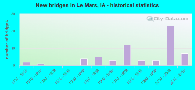
- New bridges - historical statistics
- 21900-1909
- 11910-1919
- 41940-1949
- 51950-1959
- 31960-1969
- 121970-1979
- 31980-1989
- 31990-1999
- 232000-2009
- 72010-2019
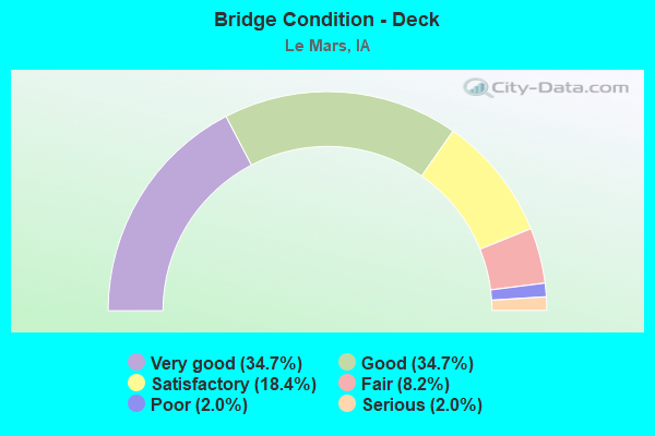
- Bridge Condition - Deck
- 34.7%Very good
- 34.7%Good
- 18.4%Satisfactory
- 8.2%Fair
- 2.0%Poor
- 2.0%Serious
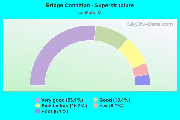
- Bridge Condition - Superstructure
- 53.1%Very good
- 18.4%Good
- 16.3%Satisfactory
- 6.1%Fair
- 6.1%Poor
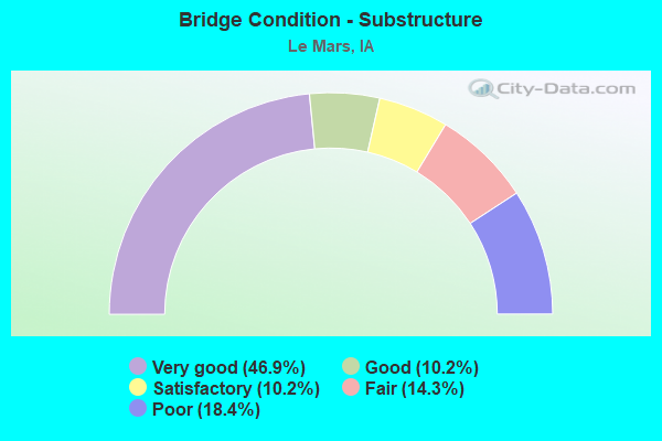
- Bridge Condition - Substructure
- 46.9%Very good
- 10.2%Good
- 10.2%Satisfactory
- 14.3%Fair
- 18.4%Poor
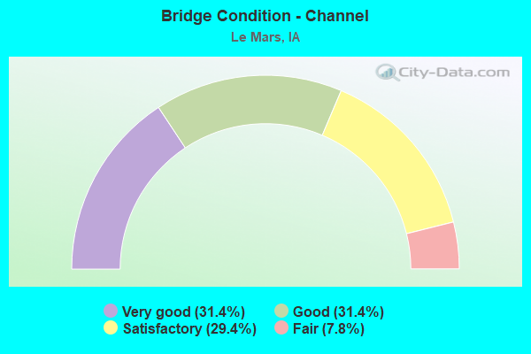
- Bridge Condition - Channel
- 31.4%Very good
- 31.4%Good
- 29.4%Satisfactory
- 7.8%Fair
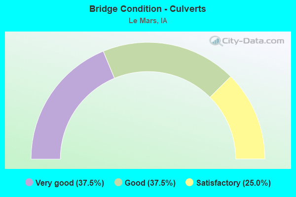
- Bridge Condition - Culverts
- 37.5%Very good
- 37.5%Good
- 25.0%Satisfactory
Find on map >> Show street view
Structure Number: 39631, Location: 0.4 mi. N of jct. IA 3 (Lat: 42.800047, Lng: -96.174125), Route carried "on" structure: State highway 404, Year Built: 1972, Status: Open, Structure Length: 9.02m (29.59ft), Average Daily Traffic: 2,190 (year 2020), Truck Traffic: 9%, Average Future Daily Traffic: 2,190 (year 2040), Design Load: HS 20, Features Intersected: FLOYD RIVER
Minimum Vertical Clearance: 30+ m (98+ ft), Kilometerpoint: 0.779, Lanes on structure: 2, Owner: State Highway Agency, Approaching Roadway Width: 12.2m (40.0ft), Material/Design: Prestressed concrete, Design/Construction: Stringer/Multi-beam, Number Of Spans In Main Unit: 4, Length of Maximum Span: 23.5m (77.1ft), Curb-To-Curb Width: 12.2m (40.0ft), Out-to-Out Width: 13.2m (43.3ft)
Condition: Deck: Satisfactory, Superstructure: Satisfactory, Substructure: Satisfactory, Channel: Satisfactory, Operating Rating: 75.6 metric tons, Method Used To Determine Operating Rating: Load Factor (LF), Inventory Rating: 39.7 metric tons, Method Used To Determine Inventory Rating: Load Factor (LF), Structural Evaluation: Equal to present minimum criteria, Deck Geometry: Better than present minimum criteria, Waterway Adequacy: Equal to present desirable criteria, Approach Roadway Alignment: Equal to present desirable criteria, Designated Inspection Frequency: Every 24 months, Inspection Date: December 2020, Deck Structure Type: Concrete Cast-file-Place, Wearing Surface/Protective System: Wearing Surface: Low Slump Concrete
Find on map >> Show street view
Structure Number: 39841, Location: 0.7 mi. W of US 75 (Lat: 42.793167, Lng: -96.218689), Route carried "on" structure: State highway 3, Year Built: 2004, Status: Open, Structure Length: 7.80m (25.59ft), Average Daily Traffic: 1,860 (year 2020), Truck Traffic: 20%, Average Future Daily Traffic: 1,860 (year 2041), Design Load: HS 20, Features Intersected: W FORK OF FLOYD RIVER
Minimum Vertical Clearance: 30+ m (98+ ft), Kilometerpoint: 40.770, Lanes on structure: 2, Base Highway Network: Yes, Owner: State Highway Agency, Approaching Roadway Width: 12.2m (40.0ft), Material/Design: Prestressed concrete, Design/Construction: Stringer/Multi-beam, Number Of Spans In Main Unit: 3, Length of Maximum Span: 37.2m (122.0ft), Curb-To-Curb Width: 13.4m (44.0ft), Out-to-Out Width: 14.4m (47.2ft)
Condition: Deck: Good, Superstructure: Very good, Substructure: Very good, Channel: Very good, Operating Rating: 72.8 metric tons, Method Used To Determine Operating Rating: Load Factor (LF), Inventory Rating: 32.4 metric tons, Method Used To Determine Inventory Rating: Load Factor (LF), Structural Evaluation: Equal to present desirable criteria, Deck Geometry: Equal to present desirable criteria, Waterway Adequacy: Equal to present desirable criteria, Approach Roadway Alignment: Equal to present desirable criteria, Designated Inspection Frequency: Every 24 months, Inspection Date: Febuary 2021, Deck Structure Type: Concrete Cast-file-Place, Wearing Surface/Protective System: Wearing Surface: Monolithic Concrete, Deck Protection: Epoxy Coated Reinforcing
Find on map >> Show street view
Structure Number: 39851, Location: 1.0 mi. E of US 75 (Lat: 42.793250, Lng: -96.184778), Route carried "on" structure: State highway 3, Year Built: 1981, Status: Open, Structure Length: 10.61m (34.81ft), Average Daily Traffic: 3,880 (year 2020), Truck Traffic: 8%, Average Future Daily Traffic: 3,880 (year 2042), Design Load: HS 20+Mod, Features Intersected: FLOYD RIVER
Minimum Vertical Clearance: 30+ m (98+ ft), Kilometerpoint: 43.544, Lanes on structure: 2, Base Highway Network: Yes, Owner: State Highway Agency, Approaching Roadway Width: 13.4m (44.0ft), Material/Design: Prestressed concrete, Design/Construction: Stringer/Multi-beam, Number Of Spans In Main Unit: 5, Length of Maximum Span: 21.0m (68.9ft), Curb-To-Curb Width: 13.4m (44.0ft), Out-to-Out Width: 14.5m (47.6ft)
Condition: Deck: Fair, Superstructure: Good, Substructure: Satisfactory, Channel: Good, Operating Rating: 73.7 metric tons, Method Used To Determine Operating Rating: Allowable Stress (AS), Inventory Rating: 33.2 metric tons, Method Used To Determine Inventory Rating: Allowable Stress (AS), Structural Evaluation: Equal to present minimum criteria, Deck Geometry: Better than present minimum criteria, Waterway Adequacy: Equal to present desirable criteria, Approach Roadway Alignment: Equal to present desirable criteria, Designated Inspection Frequency: Every 24 months, Inspection Date: Febuary 2022, Deck Structure Type: Concrete Cast-file-Place, Wearing Surface/Protective System: Wearing Surface: Monolithic Concrete, Deck Protection: Epoxy Coated Reinforcing
Find on map >> Show street view
Structure Number: 40041, Location: 093452329 (Lat: 42.854300, Lng: -96.126608), Route carried "on" structure: County highway , Year Built: 1974, Status: Open, Structure Length: 1.80m (5.91ft), Average Daily Traffic: 5 (year 2019), Average Future Daily Traffic: 5 (year 2041), Design Load: HS 20, Features Intersected: SMALL NATURAL STREAM, Facility Carried by Structure: MALLARD AVE
Minimum Vertical Clearance: 30+ m (98+ ft), Kilometerpoint: 1.783, Lanes on structure: 2, Owner: County Highway Agency, Approaching Roadway Width: 9.8m (32.2ft), Skew: 4 degrees, Material/Design: Prestressed concrete, Design/Construction: Stringer/Multi-beam, Number Of Spans In Main Unit: 1, Length of Maximum Span: 16.8m (55.1ft), Curb-To-Curb Width: 13.4m (44.0ft), Out-to-Out Width: 14.4m (47.2ft)
Condition: Deck: Satisfactory, Superstructure: Very good, Substructure: Very good, Channel: Good, Operating Rating: 45.2 metric tons, Method Used To Determine Operating Rating: Load Factor (LF), Inventory Rating: 27.1 metric tons, Method Used To Determine Inventory Rating: Load Factor (LF), Structural Evaluation: Equal to present minimum criteria, Deck Geometry: Superior to present desirable criteria, Waterway Adequacy: Equal to present minimum criteria, Approach Roadway Alignment: Somewhat better than minimum adequacy, Length Of Structure Improvement: 6.00m (19.69ft), Designated Inspection Frequency: Every 24 months, Inspection Date: June 2021, Bridge Improvement Cost: $180,000, Roadway Improvement Cost: $30,000, Deck Structure Type: Concrete Cast-file-Place, Wearing Surface/Protective System: Wearing Surface: Monolithic Concrete
Find on map >> Show street view
Structure Number: 230181, Location: 099461801 (Lat: 43.404097, Lng: -96.319103), Route carried "on" structure: County highway , Year Built: 1971, Status: Posted for load-capacity, Structure Length: 4.63m (15.19ft), Average Daily Traffic: 110 (year 2015), Average Future Daily Traffic: 110 (year 2041), Features Intersected: MUD CREEK, Facility Carried by Structure: LOCAL ROAD
Minimum Vertical Clearance: 30+ m (98+ ft), Kilometerpoint: 13.594, Lanes on structure: 2, Owner: County Highway Agency, Approaching Roadway Width: 7.9m (25.9ft), Material/Design: Steel continuous, Design/Construction: Stringer/Multi-beam, Number Of Spans In Main Unit: 3, Length of Maximum Span: 18.0m (59.1ft), Curb-To-Curb Width: 7.4m (24.3ft), Out-to-Out Width: 7.9m (25.9ft)
Condition: Deck: Fair, Superstructure: Good, Substructure: Satisfactory, Channel: Satisfactory, Operating Rating: 33.5 metric tons, Method Used To Determine Operating Rating: Load Factor (LF), Inventory Rating: 20.0 metric tons, Method Used To Determine Inventory Rating: Load Factor (LF), Structural Evaluation: Somewhat better than minimum adequacy, Deck Geometry: Somewhat better than minimum adequacy, Waterway Adequacy: Better than present minimum criteria, Approach Roadway Alignment: Better than present minimum criteria, Bridge Posting: Required (Relationship of Operating Rating to Maximum Legal Load: 0.1 - 9.9% below), Length Of Structure Improvement: 15.20m (49.87ft), Designated Inspection Frequency: Every 24 months, Inspection Date: July 2021, Bridge Improvement Cost: $15,000, Roadway Improvement Cost: $2,000, Deck Structure Type: Concrete Cast-file-Place, Wearing Surface/Protective System: Wearing Surface: Monolithic Concrete
Find on map >> Show street view
Structure Number: 23036, Location: 099470104 (Lat: 43.422986, Lng: -96.330339), Route carried "on" structure: County highway , Year Built: 1970, Status: Open, Structure Length: 4.57m (14.99ft), Average Daily Traffic: 450 (year 2019), Average Future Daily Traffic: 450 (year 2041), Features Intersected: MUD CREEK, Facility Carried by Structure: FM
Minimum Vertical Clearance: 30+ m (98+ ft), Kilometerpoint: 16.755, Lanes on structure: 2, Owner: County Highway Agency, Approaching Roadway Width: 7.9m (25.9ft), Material/Design: Steel continuous, Design/Construction: Stringer/Multi-beam, Number Of Spans In Main Unit: 3, Length of Maximum Span: 17.7m (58.1ft), Curb-To-Curb Width: 8.6m (28.2ft), Out-to-Out Width: 9.1m (29.9ft)
Condition: Deck: Fair, Superstructure: Good, Substructure: Fair, Channel: Satisfactory, Operating Rating: 39.0 metric tons, Method Used To Determine Operating Rating: Allowable Stress (AS), Inventory Rating: 26.3 metric tons, Method Used To Determine Inventory Rating: Allowable Stress (AS), Structural Evaluation: Somewhat better than minimum adequacy, Deck Geometry: Somewhat better than minimum adequacy, Waterway Adequacy: Better than present minimum criteria, Approach Roadway Alignment: Equal to present desirable criteria, Length Of Structure Improvement: 15.00m (49.21ft), Designated Inspection Frequency: Every 24 months, Inspection Date: July 2021, Bridge Improvement Cost: $15,000, Roadway Improvement Cost: $2,000, Deck Structure Type: Concrete Cast-file-Place, Wearing Surface/Protective System: Wearing Surface: Monolithic Concrete
Find on map >> Show street view
Structure Number: 272871, Location: 091450301 (Lat: 42.735175, Lng: -96.147758), Route carried "on" structure: County highway , Year Built: 2004, Status: Open, Structure Length: 3.90m (12.80ft), Average Daily Traffic: 15 (year 2019), Average Future Daily Traffic: 15 (year 2040), Design Load: HS 20, Features Intersected: PLYMOUTH CREEK, Facility Carried by Structure: 220TH ST
Minimum Vertical Clearance: 30+ m (98+ ft), Kilometerpoint: 23.918, Lanes on structure: 2, Owner: County Highway Agency, Approaching Roadway Width: 8.5m (27.9ft), Skew: 3 degrees, Material/Design: Concrete, Design/Construction: Slab, Number Of Spans In Main Unit: 3, Length of Maximum Span: 14.9m (48.9ft), Curb-To-Curb Width: 9.2m (30.2ft), Out-to-Out Width: 10.1m (33.1ft)
Condition: Deck: Good, Superstructure: Good, Substructure: Good, Channel: Very good, Operating Rating: 88.5 metric tons, Method Used To Determine Operating Rating: Load Factor (LF), Inventory Rating: 52.9 metric tons, Method Used To Determine Inventory Rating: Load Factor (LF), Structural Evaluation: Better than present minimum criteria, Deck Geometry: Better than present minimum criteria, Waterway Adequacy: Equal to present desirable criteria, Approach Roadway Alignment: Equal to present desirable criteria, Length Of Structure Improvement: 13.00m (42.65ft), Designated Inspection Frequency: Every 24 months, Inspection Date: April 2020, Bridge Improvement Cost: $520,000, Roadway Improvement Cost: $15,000, Deck Structure Type: Concrete Cast-file-Place
Find on map >> Show street view
Structure Number: 272891, Location: 091450302 (Lat: 42.729303, Lng: -96.156044), Route carried "on" structure: County highway , Year Built: 1974, Status: Open, Structure Length: 3.81m (12.50ft), Average Daily Traffic: 1,240 (year 2019), Average Future Daily Traffic: 1,240 (year 2040), Design Load: HS 20, Features Intersected: PLYMOUTH CR, Facility Carried by Structure: FM K-49
Minimum Vertical Clearance: 30+ m (98+ ft), Kilometerpoint: 18.649, Lanes on structure: 2, Owner: County Highway Agency, Approaching Roadway Width: 7.0m (23.0ft), Material/Design: Concrete continuous, Design/Construction: Slab, Number Of Spans In Main Unit: 3, Length of Maximum Span: 14.9m (48.9ft), Curb-To-Curb Width: 9.1m (29.9ft), Out-to-Out Width: 9.8m (32.2ft)
Condition: Deck: Satisfactory, Superstructure: Good, Substructure: Good, Channel: Satisfactory, Operating Rating: 52.1 metric tons, Method Used To Determine Operating Rating: Allowable Stress (AS), Inventory Rating: 30.2 metric tons, Method Used To Determine Inventory Rating: Allowable Stress (AS), Structural Evaluation: Better than present minimum criteria, Deck Geometry: Somewhat better than minimum adequacy, Waterway Adequacy: Somewhat better than minimum adequacy, Approach Roadway Alignment: Equal to present desirable criteria, Length Of Structure Improvement: 14.00m (45.93ft), Designated Inspection Frequency: Every 24 months, Inspection Date: April 2020, Bridge Improvement Cost: $560,000, Roadway Improvement Cost: $30,000, Deck Structure Type: Concrete Cast-file-Place, Wearing Surface/Protective System: Wearing Surface: Monolithic Concrete
Find on map >> Show street view
Structure Number: 2729, Location: 091450402 (Lat: 42.730647, Lng: -96.175550), Route carried "on" structure: County highway , Year Built: 1960, Status: Posted for load, Structure Length: 1.83m (6.00ft), Average Daily Traffic: 25 (year 2019), Average Future Daily Traffic: 25 (year 2041), Design Load: HS 20, Features Intersected: PLYMOUTH CREEK, Facility Carried by Structure: LYNX AVE
Minimum Vertical Clearance: 30+ m (98+ ft), Kilometerpoint: 18.903, Lanes on structure: 1, Owner: County Highway Agency, Approaching Roadway Width: 9.4m (30.8ft), Material/Design: Steel, Design/Construction: Truss - Thru, Number Of Spans In Main Unit: 1, Length of Maximum Span: 18.3m (60.0ft), Curb-To-Curb Width: 5.5m (18.0ft), Out-to-Out Width: 5.5m (18.0ft)
Condition: Deck: Satisfactory, Superstructure: Poor, Substructure: Poor, Channel: Fair, Operating Rating: 14.4 metric tons, Method Used To Determine Operating Rating: Load Factor (LF), Inventory Rating: 8.7 metric tons, Method Used To Determine Inventory Rating: Load Factor (LF), Structural Evaluation: High priority of replacement, Deck Geometry: Meets minimum limits, Waterway Adequacy: Equal to present desirable criteria, Approach Roadway Alignment: Equal to present desirable criteria, Bridge Posting: Required (Relationship of Operating Rating to Maximum Legal Load: > 39.9% below), Length Of Structure Improvement: 9.00m (29.53ft), Designated Inspection Frequency: Every 12 months, Critical Feature Inspection Frequency: Every 12 months, Inspection Date: April 2021, Critical Feature Inspection Date: April 2021, Bridge Improvement Cost: $270,000, Roadway Improvement Cost: $20,000, Deck Structure Type: Wood or Timber, Wearing Surface/Protective System: Wearing Surface: Gravel
Find on map >> Show street view
Structure Number: 272911, Location: 091450502 (Lat: 42.733064, Lng: -96.195175), Route carried "on" structure: County highway , Year Built: 1977, Status: Open, Structure Length: 3.81m (12.50ft), Average Daily Traffic: 160 (year 2019), Average Future Daily Traffic: 160 (year 2040), Design Load: HS 20, Features Intersected: PLYMOUTH CREEK, Facility Carried by Structure: LAKE AVE
Minimum Vertical Clearance: 30+ m (98+ ft), Kilometerpoint: 19.061, Lanes on structure: 2, Owner: County Highway Agency, Approaching Roadway Width: 6.7m (22.0ft), Material/Design: Concrete, Design/Construction: Slab, Number Of Spans In Main Unit: 3, Length of Maximum Span: 14.9m (48.9ft), Curb-To-Curb Width: 9.1m (29.9ft), Out-to-Out Width: 10.1m (33.1ft)
Condition: Deck: Good, Superstructure: Very good, Substructure: Very good, Channel: Satisfactory, Operating Rating: 52.1 metric tons, Method Used To Determine Operating Rating: Allowable Stress (AS), Inventory Rating: 30.2 metric tons, Method Used To Determine Inventory Rating: Allowable Stress (AS), Structural Evaluation: Better than present minimum criteria, Deck Geometry: Equal to present minimum criteria, Waterway Adequacy: Superior to present desirable criteria, Approach Roadway Alignment: Superior to present desirable criteria, Length Of Structure Improvement: 14.00m (45.93ft), Designated Inspection Frequency: Every 24 months, Inspection Date: April 2020, Bridge Improvement Cost: $560,000, Roadway Improvement Cost: $15,000, Deck Structure Type: Concrete Cast-file-Place, Wearing Surface/Protective System: Wearing Surface: Monolithic Concrete
Find on map >> Show street view
Structure Number: 27292, Location: 091450501 (Lat: 42.735214, Lng: -96.178225), Route carried "on" structure: County highway , Year Built: 1958, Status: Posted for load, Structure Length: 1.01m (3.31ft), Average Daily Traffic: 25 (year 2019), Average Future Daily Traffic: 25 (year 2040), Design Load: HS 20, Features Intersected: DRAINAGE, Facility Carried by Structure: 220TH ST
Minimum Vertical Clearance: 30+ m (98+ ft), Kilometerpoint: 21.424, Lanes on structure: 2, Owner: County Highway Agency, Approaching Roadway Width: 7.0m (23.0ft), Material/Design: Steel, Design/Construction: Stringer/Multi-beam, Number Of Spans In Main Unit: 1, Length of Maximum Span: 10.1m (33.1ft), Curb-To-Curb Width: 6.1m (20.0ft), Out-to-Out Width: 6.2m (20.3ft)
Condition: Deck: Satisfactory, Superstructure: Satisfactory, Substructure: Fair, Channel: Satisfactory, Operating Rating: 26.1 metric tons, Method Used To Determine Operating Rating: Allowable Stress (AS), Inventory Rating: 14.7 metric tons, Method Used To Determine Inventory Rating: Allowable Stress (AS), Structural Evaluation: Meets minimum limits, Deck Geometry: Somewhat better than minimum adequacy, Waterway Adequacy: Equal to present minimum criteria, Approach Roadway Alignment: Equal to present desirable criteria, Bridge Posting: Required (Relationship of Operating Rating to Maximum Legal Load: 0.1 - 9.9% below), Length Of Structure Improvement: 5.00m (16.40ft), Designated Inspection Frequency: Every 24 months, Inspection Date: April 2020, Bridge Improvement Cost: $200,000, Roadway Improvement Cost: $15,000, Deck Structure Type: Wood or Timber, Wearing Surface/Protective System: Wearing Surface: Gravel
Find on map >> Show street view
Structure Number: 272941, Location: 091450901 (Lat: 42.721439, Lng: -96.157739), Route carried "on" structure: County highway , Year Built: 1977, Status: Open, Structure Length: 3.05m (10.01ft), Average Daily Traffic: 340 (year 2019), Average Future Daily Traffic: 340 (year 2040), Design Load: HS 20, Features Intersected: MINNIE BROOK, Facility Carried by Structure: FM C-44
Minimum Vertical Clearance: 30+ m (98+ ft), Kilometerpoint: 25.339, Lanes on structure: 2, Owner: County Highway Agency, Approaching Roadway Width: 6.7m (22.0ft), Skew: 3 degrees, Material/Design: Concrete, Design/Construction: Slab, Number Of Spans In Main Unit: 3, Length of Maximum Span: 11.9m (39.0ft), Curb-To-Curb Width: 9.1m (29.9ft), Out-to-Out Width: 9.8m (32.2ft)
Condition: Deck: Good, Superstructure: Very good, Substructure: Very good, Channel: Good, Operating Rating: 49.8 metric tons, Method Used To Determine Operating Rating: Allowable Stress (AS), Inventory Rating: 30.0 metric tons, Method Used To Determine Inventory Rating: Allowable Stress (AS), Structural Evaluation: Better than present minimum criteria, Deck Geometry: Equal to present minimum criteria, Waterway Adequacy: Equal to present desirable criteria, Approach Roadway Alignment: Equal to present minimum criteria, Length Of Structure Improvement: 12.00m (39.37ft), Designated Inspection Frequency: Every 24 months, Inspection Date: April 2020, Bridge Improvement Cost: $480,000, Roadway Improvement Cost: $30,000, Deck Structure Type: Concrete Cast-file-Place, Wearing Surface/Protective System: Wearing Surface: Monolithic Concrete
Find on map >> Show street view
Structure Number: 272951, Location: 091451002 (Lat: 42.720106, Lng: -96.156222), Route carried "on" structure: County highway , Year Built: 1975, Status: Open, Structure Length: 0.64m (2.10ft), Average Daily Traffic: 1,020 (year 2019), Truck Traffic: 12%, Average Future Daily Traffic: 1,020 (year 2040), Design Load: H 20, Features Intersected: DRAINAGE, Facility Carried by Structure: FM K-49
Minimum Vertical Clearance: 30+ m (98+ ft), Kilometerpoint: 17.627, Lanes on structure: 2, Owner: County Highway Agency, Approaching Roadway Width: 8.5m (27.9ft), Material/Design: Concrete, Design/Construction: Culvert, Number Of Spans In Main Unit: 2, Length of Maximum Span: 3.0m (9.8ft)
Condition: Channel: Very good, Culverts: Good, Operating Rating: 44.4 metric tons, Method Used To Determine Operating Rating: Field evaluation and documented engineering judgment, Inventory Rating: 32.7 metric tons, Method Used To Determine Inventory Rating: Field evaluation and documented engineering judgment, Structural Evaluation: Better than present minimum criteria, Waterway Adequacy: Equal to present desirable criteria, Approach Roadway Alignment: Equal to present desirable criteria, Length Of Structure Improvement: 3.00m (9.84ft), Designated Inspection Frequency: Every 24 months, Inspection Date: April 2020, Bridge Improvement Cost: $120,000, Roadway Improvement Cost: $30,000
Find on map >> Show street view
Structure Number: 274411, Location: 092441902 (Lat: 42.765806, Lng: -96.096469), Route carried "on" structure: County highway , Year Built: 2000, Status: Open, Structure Length: 2.68m (8.79ft), Average Daily Traffic: 80 (year 2019), Average Future Daily Traffic: 80 (year 2041), Design Load: HS 20, Features Intersected: PLYMOUTH CREEK, Facility Carried by Structure: NOBLE AVE
Minimum Vertical Clearance: 30+ m (98+ ft), Kilometerpoint: 21.105, Lanes on structure: 2, Owner: County Highway Agency, Approaching Roadway Width: 9.1m (29.9ft), Material/Design: Concrete continuous, Design/Construction: Slab, Number Of Spans In Main Unit: 3, Length of Maximum Span: 10.4m (34.1ft), Curb-To-Curb Width: 9.1m (29.9ft), Out-to-Out Width: 9.8m (32.2ft)
Condition: Deck: Very good, Superstructure: Very good, Substructure: Very good, Channel: Very good, Operating Rating: 75.9 metric tons, Method Used To Determine Operating Rating: Load Factor (LF), Inventory Rating: 45.4 metric tons, Method Used To Determine Inventory Rating: Load Factor (LF), Structural Evaluation: Equal to present desirable criteria, Deck Geometry: Better than present minimum criteria, Waterway Adequacy: Equal to present desirable criteria, Approach Roadway Alignment: Equal to present desirable criteria, Length Of Structure Improvement: 9.00m (29.53ft), Designated Inspection Frequency: Every 24 months, Inspection Date: May 2021, Bridge Improvement Cost: $270,000, Roadway Improvement Cost: $15,000, Deck Structure Type: Concrete Cast-file-Place, Wearing Surface/Protective System: Wearing Surface: Monolithic Concrete
Find on map >> Show street view
Structure Number: 274421, Location: 092441902 (Lat: 42.768553, Lng: -96.096414), Route carried "on" structure: County highway , Year Built: 2000, Status: Open, Structure Length: 3.44m (11.29ft), Average Daily Traffic: 80 (year 2019), Average Future Daily Traffic: 80 (year 2041), Design Load: HS 20, Features Intersected: PLYMOUTH CREEK, Facility Carried by Structure: NOBLE AVE
Minimum Vertical Clearance: 30+ m (98+ ft), Kilometerpoint: 21.409, Lanes on structure: 2, Owner: County Highway Agency, Approaching Roadway Width: 9.1m (29.9ft), Material/Design: Concrete continuous, Design/Construction: Slab, Number Of Spans In Main Unit: 3, Length of Maximum Span: 13.4m (44.0ft), Curb-To-Curb Width: 9.1m (29.9ft), Out-to-Out Width: 9.8m (32.2ft)
Condition: Deck: Very good, Superstructure: Very good, Substructure: Very good, Channel: Good, Operating Rating: 83.4 metric tons, Method Used To Determine Operating Rating: Load Factor (LF), Inventory Rating: 50.0 metric tons, Method Used To Determine Inventory Rating: Load Factor (LF), Structural Evaluation: Equal to present desirable criteria, Deck Geometry: Better than present minimum criteria, Waterway Adequacy: Equal to present desirable criteria, Approach Roadway Alignment: Equal to present desirable criteria, Length Of Structure Improvement: 12.00m (39.37ft), Designated Inspection Frequency: Every 24 months, Inspection Date: May 2021, Bridge Improvement Cost: $360,000, Roadway Improvement Cost: $30,000, Deck Structure Type: Concrete Cast-file-Place, Wearing Surface/Protective System: Wearing Surface: Other
Find on map >> Show street view
Structure Number: 27451, Location: 092443001 (Lat: 42.764367, Lng: -96.094497), Route carried "on" structure: County highway , Year Built: 1952, Year Reconstructed: 1978, Status: Posted for load, Structure Length: 1.04m (3.41ft), Average Daily Traffic: 15 (year 2019), Average Future Daily Traffic: 15 (year 2041), Design Load: HS 20, Features Intersected: PLYMOUTH CREEK, Facility Carried by Structure: 200TH ST
Minimum Vertical Clearance: 30+ m (98+ ft), Kilometerpoint: 36.526, Lanes on structure: 1, Owner: County Highway Agency, Approaching Roadway Width: 7.3m (24.0ft), Material/Design: Wood or Timber, Design/Construction: Stringer/Multi-beam, Number Of Spans In Main Unit: 1, Number Of Approach Spans: 1, Length of Maximum Span: 5.8m (19.0ft), Curb-To-Curb Width: 6.0m (19.7ft), Out-to-Out Width: 6.1m (20.0ft)
Condition: Deck: Good, Superstructure: Satisfactory, Substructure: Poor, Channel: Fair, Operating Rating: 21.9 metric tons, Method Used To Determine Operating Rating: Allowable Stress (AS), Inventory Rating: 14.7 metric tons, Method Used To Determine Inventory Rating: Allowable Stress (AS), Structural Evaluation: Meets minimum limits, Deck Geometry: Meets minimum limits, Waterway Adequacy: Equal to present desirable criteria, Approach Roadway Alignment: Equal to present minimum criteria, Bridge Posting: Required (Relationship of Operating Rating to Maximum Legal Load: 20.0 - 29.9% below), Length Of Structure Improvement: 7.00m (22.97ft), Designated Inspection Frequency: Every 24 months, Inspection Date: May 2021, Bridge Improvement Cost: $210,000, Roadway Improvement Cost: $15,000, Deck Structure Type: Wood or Timber, Wearing Surface/Protective System: Wearing Surface: Other
Find on map >> Show street view
Structure Number: 274561, Location: 9245040110 (Lat: 42.822281, Lng: -96.158717), Route carried "on" structure: County highway , Year Built: 2013, Status: Open, Structure Length: 6.98m (22.90ft), Average Daily Traffic: 130 (year 2019), Average Future Daily Traffic: 130 (year 2041), Design Load: HL 93, Features Intersected: FLOYD RIVER, Facility Carried by Structure: 160TH ST
Minimum Vertical Clearance: 30+ m (98+ ft), Kilometerpoint: 25.115, Lanes on structure: 2, Owner: County Highway Agency, Approaching Roadway Width: 9.1m (29.9ft), Material/Design: Prestressed concrete continuous, Design/Construction: Stringer/Multi-beam, Number Of Spans In Main Unit: 1, Number Of Approach Spans: 2, Length of Maximum Span: 24.4m (80.1ft), Curb-To-Curb Width: 9.3m (30.5ft), Out-to-Out Width: 10.1m (33.1ft)
Condition: Deck: Very good, Superstructure: Very good, Substructure: Good, Channel: Very good, Operating Rating: 32.4 metric tons, Method Used To Determine Operating Rating: Load and Resistance Factor Rating (LRFR) rating reported by rating factor(RF) method using HL-93 loadings, Inventory Rating: 32.4 metric tons, Method Used To Determine Inventory Rating: Load and Resistance Factor Rating (LRFR) rating reported by rating factor(RF) method using HL-93 loadings, Structural Evaluation: Better than present minimum criteria, Deck Geometry: Equal to present minimum criteria, Waterway Adequacy: Equal to present desirable criteria, Approach Roadway Alignment: Equal to present desirable criteria, Designated Inspection Frequency: Every 24 months, Inspection Date: June 2021, Deck Structure Type: Concrete Cast-file-Place
Find on map >> Show street view
Structure Number: 27458, Location: 092450603 (Lat: 42.814811, Lng: -96.212031), Route carried "on" structure: County highway , Year Built: 1911, Status: Posted for load, Structure Length: 2.23m (7.32ft), Average Daily Traffic: 120 (year 2019), Average Future Daily Traffic: 120 (year 2041), Features Intersected: WEST BRANCH FLOYD RIVER, Facility Carried by Structure: 165TH ST
Minimum Vertical Clearance: 30+ m (98+ ft), Kilometerpoint: 1.736, Lanes on structure: 1, Owner: County Highway Agency, Approaching Roadway Width: 9.4m (30.8ft), Material/Design: Concrete, Design/Construction: Arch - Deck, Number Of Spans In Main Unit: 1, Length of Maximum Span: 22.3m (73.2ft), Curb-To-Curb Width: 5.0m (16.4ft), Out-to-Out Width: 5.3m (17.4ft)
Condition: Deck: Serious, Superstructure: Poor, Substructure: Poor, Channel: Satisfactory, Operating Rating: 7.2 metric tons, Method Used To Determine Operating Rating: Field evaluation and documented engineering judgment, Inventory Rating: 4.5 metric tons, Method Used To Determine Inventory Rating: Field evaluation and documented engineering judgment, Structural Evaluation: High priority of replacement, Deck Geometry: High priority of replacement, Waterway Adequacy: Better than present minimum criteria, Approach Roadway Alignment: Meets minimum limits, Bridge Posting: Required (Relationship of Operating Rating to Maximum Legal Load: > 39.9% below), Length Of Structure Improvement: 15.00m (49.21ft), Designated Inspection Frequency: Every 12 months, Inspection Date: June 2021, Bridge Improvement Cost: $450,000, Roadway Improvement Cost: $20,000, Deck Structure Type: Concrete Cast-file-Place, Wearing Surface/Protective System: Wearing Surface: Wood or Timber
Find on map >> Show street view
Structure Number: 274591, Location: 1.0 mi N of jct IA 3 (Lat: 42.807681, Lng: -96.175267), Route carried "on" structure: County highway , Year Built: 2004, Status: Open, Structure Length: 0.88m (2.89ft), Average Daily Traffic: 470 (year 2019), Average Future Daily Traffic: 470 (year 2042), Design Load: HS 20, Features Intersected: DRAINAGE, Facility Carried by Structure: 170TH ST (SDB)
Minimum Vertical Clearance: 30+ m (98+ ft), Kilometerpoint: 26.015, Lanes on structure: 2, Owner: State Highway Agency, Approaching Roadway Width: 11.0m (36.1ft), Material/Design: Concrete, Design/Construction: Culvert, Number Of Spans In Main Unit: 1, Length of Maximum Span: 8.5m (27.9ft)
Condition: Channel: Very good, Culverts: Very good, Operating Rating: 44.4 metric tons, Method Used To Determine Operating Rating: Assigned rating based on Load Factor Design (LFD) reported in metric tons, Inventory Rating: 32.7 metric tons, Method Used To Determine Inventory Rating: Assigned rating based on Load Factor Design (LFD) reported in metric tons, Structural Evaluation: Equal to present desirable criteria, Waterway Adequacy: Equal to present desirable criteria, Approach Roadway Alignment: Equal to present desirable criteria, Designated Inspection Frequency: Every 24 months, Inspection Date: Febuary 2022
Find on map >> Show street view
Structure Number: 274601, Location: 000000000 (Lat: 42.803817, Lng: -96.158511), Route carried "on" structure: City street , Year Built: 1993, Status: Open, Structure Length: 5.76m (18.90ft), Average Daily Traffic: 890 (year 2019), Average Future Daily Traffic: 890 (year 2041), Design Load: HS 20, Features Intersected: WILLOW CREEK, Facility Carried by Structure: 4TH AVE.E
Minimum Vertical Clearance: 30+ m (98+ ft), Kilometerpoint: 1.254, Lanes on structure: 2, Owner: City or Municipal Highway Agency, Approaching Roadway Width: 8.5m (27.9ft), Skew: 3 degrees, Material/Design: Prestressed concrete, Design/Construction: Stringer/Multi-beam, Number Of Spans In Main Unit: 3, Length of Maximum Span: 21.0m (68.9ft), Curb or Sidewalk Widths: Left: 2.4m (7.9ft), Right: 0.0m, Curb-To-Curb Width: 9.8m (32.2ft), Out-to-Out Width: 10.7m (35.1ft)
Condition: Deck: Very good, Superstructure: Very good, Substructure: Very good, Channel: Good, Operating Rating: 45.4 metric tons, Method Used To Determine Operating Rating: Load Factor (LF), Inventory Rating: 27.2 metric tons, Method Used To Determine Inventory Rating: Load Factor (LF), Structural Evaluation: Equal to present minimum criteria, Deck Geometry: Equal to present minimum criteria, Waterway Adequacy: Equal to present desirable criteria, Approach Roadway Alignment: Equal to present desirable criteria, Length Of Structure Improvement: 18.90m (62.01ft), Designated Inspection Frequency: Every 24 months, Inspection Date: December 2021, Bridge Improvement Cost: $500,000, Roadway Improvement Cost: $30,000, Deck Structure Type: Concrete Cast-file-Place
Find on map >> Show street view
Structure Number: 274611, Location: 092451104 (Lat: 42.804508, Lng: -96.134994), Route carried "on" structure: County highway , Year Built: 1994, Status: Open, Structure Length: 5.82m (19.09ft), Average Daily Traffic: 540 (year 2019), Average Future Daily Traffic: 540 (year 2041), Design Load: HS 20, Features Intersected: WILLOW CREEK, Facility Carried by Structure: MARBLE AVE
Minimum Vertical Clearance: 30+ m (98+ ft), Kilometerpoint: 22.265, Lanes on structure: 2, Owner: County Highway Agency, Approaching Roadway Width: 11.3m (37.1ft), Material/Design: Prestressed concrete continuous, Design/Construction: Stringer/Multi-beam, Number Of Spans In Main Unit: 3, Length of Maximum Span: 21.0m (68.9ft), Curb-To-Curb Width: 9.1m (29.9ft), Out-to-Out Width: 10.0m (32.8ft)
Condition: Deck: Good, Superstructure: Very good, Substructure: Very good, Channel: Very good, Operating Rating: 85.3 metric tons, Method Used To Determine Operating Rating: Load Factor (LF), Inventory Rating: 36.9 metric tons, Method Used To Determine Inventory Rating: Load Factor (LF), Structural Evaluation: Equal to present desirable criteria, Deck Geometry: Equal to present minimum criteria, Waterway Adequacy: Equal to present desirable criteria, Approach Roadway Alignment: Equal to present minimum criteria, Length Of Structure Improvement: 20.00m (65.62ft), Designated Inspection Frequency: Every 24 months, Inspection Date: June 2021, Bridge Improvement Cost: $800,000, Roadway Improvement Cost: $25,000, Deck Structure Type: Concrete Cast-file-Place
Find on map >> Show street view
Structure Number: 274661, Location: 092451907 (Lat: 42.771419, Lng: -96.202783), Route carried "on" structure: County highway , Year Built: 1975, Status: Open, Structure Length: 9.54m (31.30ft), Average Daily Traffic: 60 (year 2019), Average Future Daily Traffic: 60 (year 2041), Design Load: H 20, Features Intersected: FLOYD RIVER, Facility Carried by Structure: 195TH STREET
Minimum Vertical Clearance: 30+ m (98+ ft), Kilometerpoint: 0.463, Lanes on structure: 2, Owner: County Highway Agency, Approaching Roadway Width: 7.6m (24.9ft), Skew: 4 degrees, Material/Design: Steel, Design/Construction: Stringer/Multi-beam, Number Of Spans In Main Unit: 4, Length of Maximum Span: 27.4m (89.9ft), Curb-To-Curb Width: 7.3m (24.0ft), Out-to-Out Width: 7.8m (25.6ft)
Condition: Deck: Good, Superstructure: Very good, Substructure: Good, Channel: Good, Operating Rating: 44.4 metric tons, Method Used To Determine Operating Rating: Allowable Stress (AS), Inventory Rating: 28.8 metric tons, Method Used To Determine Inventory Rating: Allowable Stress (AS), Structural Evaluation: Better than present minimum criteria, Deck Geometry: Equal to present minimum criteria, Waterway Adequacy: Equal to present desirable criteria, Approach Roadway Alignment: Equal to present desirable criteria, Length Of Structure Improvement: 37.50m (123.03ft), Designated Inspection Frequency: Every 24 months, Inspection Date: June 2021, Bridge Improvement Cost: $1,500,000, Roadway Improvement Cost: $20,000, Deck Structure Type: Concrete Cast-file-Place, Wearing Surface/Protective System: Wearing Surface: Monolithic Concrete
Find on map >> Show street view
Structure Number: 27469, Location: 092452502 (Lat: 42.751753, Lng: -96.116289), Route carried "on" structure: County highway , Year Built: 1940, Status: Posted for load, Structure Length: 1.55m (5.09ft), Average Daily Traffic: 45 (year 2019), Average Future Daily Traffic: 45 (year 2041), Design Load: HS 20, Features Intersected: PLYMOUTH CREEK, Facility Carried by Structure: NATURE AVE
Minimum Vertical Clearance: 30+ m (98+ ft), Kilometerpoint: 21.155, Lanes on structure: 2, Owner: County Highway Agency, Approaching Roadway Width: 7.9m (25.9ft), Skew: 3 degrees, Material/Design: Steel, Design/Construction: Stringer/Multi-beam, Number Of Spans In Main Unit: 1, Length of Maximum Span: 15.5m (50.9ft), Curb-To-Curb Width: 6.1m (20.0ft), Out-to-Out Width: 6.5m (21.3ft)
Condition: Deck: Good, Superstructure: Satisfactory, Substructure: Fair, Channel: Good, Operating Rating: 22.6 metric tons, Method Used To Determine Operating Rating: Load Factor (LF), Inventory Rating: 13.5 metric tons, Method Used To Determine Inventory Rating: Load Factor (LF), Structural Evaluation: Meets minimum limits, Deck Geometry: Somewhat better than minimum adequacy, Waterway Adequacy: Better than present minimum criteria, Approach Roadway Alignment: Equal to present minimum criteria, Bridge Posting: Required (Relationship of Operating Rating to Maximum Legal Load: 10.0 - 19.9% below), Length Of Structure Improvement: 7.00m (22.97ft), Designated Inspection Frequency: Every 24 months, Inspection Date: June 2021, Bridge Improvement Cost: $280,000, Roadway Improvement Cost: $15,000, Deck Structure Type: Concrete Cast-file-Place, Wearing Surface/Protective System: Wearing Surface: Monolithic Concrete
Find on map >> Show street view
Structure Number: 274701, Location: 092452703 (Lat: 42.764189, Lng: -96.153889), Route carried "on" structure: County highway , Year Built: 1985, Status: Open, Structure Length: 0.79m (2.59ft), Average Daily Traffic: 160 (year 2019), Average Future Daily Traffic: 160 (year 2041), Design Load: HS 20, Features Intersected: SMALL STREAM, Facility Carried by Structure: 200TH ST
Minimum Vertical Clearance: 30+ m (98+ ft), Kilometerpoint: 33.262, Lanes on structure: 2, Owner: County Highway Agency, Approaching Roadway Width: 7.9m (25.9ft), Skew: 3 degrees, Material/Design: Concrete, Design/Construction: Culvert, Number Of Spans In Main Unit: 2, Length of Maximum Span: 3.0m (9.8ft)
Condition: Channel: Good, Culverts: Good, Operating Rating: 60.6 metric tons, Method Used To Determine Operating Rating: Load Factor (LF), Inventory Rating: 36.3 metric tons, Method Used To Determine Inventory Rating: Load Factor (LF), Structural Evaluation: Better than present minimum criteria, Waterway Adequacy: Equal to present desirable criteria, Approach Roadway Alignment: Equal to present desirable criteria, Length Of Structure Improvement: 2.60m (8.53ft), Designated Inspection Frequency: Every 24 months, Inspection Date: June 2021, Bridge Improvement Cost: $104,000, Roadway Improvement Cost: $15,000
Find on map >> Show street view
Structure Number: 274711, Location: 092452702 (Lat: 42.763069, Lng: -96.155503), Route carried "on" structure: County highway , Year Built: 1975, Status: Open, Structure Length: 0.79m (2.59ft), Average Daily Traffic: 1,450 (year 2019), Truck Traffic: 12%, Average Future Daily Traffic: 1,450 (year 2041), Features Intersected: MINNIE CREEK, Facility Carried by Structure: FM
Minimum Vertical Clearance: 30+ m (98+ ft), Kilometerpoint: 22.399, Lanes on structure: 2, Owner: County Highway Agency, Approaching Roadway Width: 8.5m (27.9ft), Skew: 3 degrees, Material/Design: Concrete, Design/Construction: Culvert, Number Of Spans In Main Unit: 2, Length of Maximum Span: 3.7m (12.1ft)
Condition: Channel: Satisfactory, Culverts: Satisfactory, Operating Rating: 44.4 metric tons, Method Used To Determine Operating Rating: Field evaluation and documented engineering judgment, Inventory Rating: 32.7 metric tons, Method Used To Determine Inventory Rating: Field evaluation and documented engineering judgment, Structural Evaluation: Equal to present minimum criteria, Waterway Adequacy: Equal to present desirable criteria, Approach Roadway Alignment: Equal to present minimum criteria, Length Of Structure Improvement: 3.00m (9.84ft), Designated Inspection Frequency: Every 24 months, Inspection Date: June 2021, Bridge Improvement Cost: $120,000, Roadway Improvement Cost: $15,000
Find on map >> Show street view
Structure Number: 274721, Location: 092453105 (Lat: 42.749697, Lng: -96.209586), Route carried "on" structure: County highway , Year Built: 2007, Status: Open, Structure Length: 8.78m (28.81ft), Average Daily Traffic: 1,570 (year 2019), Truck Traffic: 19%, Average Future Daily Traffic: 1,570 (year 2041), Design Load: HS 20, Features Intersected: FLOYD RIVER, Facility Carried by Structure: FM
Minimum Vertical Clearance: 30+ m (98+ ft), Kilometerpoint: 32.272, Lanes on structure: 2, Owner: County Highway Agency, Approaching Roadway Width: 9.1m (29.9ft), Material/Design: Prestressed concrete, Design/Construction: Stringer/Multi-beam, Number Of Spans In Main Unit: 3, Length of Maximum Span: 29.3m (96.1ft), Curb-To-Curb Width: 9.1m (29.9ft), Out-to-Out Width: 10.1m (33.1ft)
Condition: Deck: Very good, Superstructure: Very good, Substructure: Very good, Channel: Very good, Operating Rating: 82.9 metric tons, Method Used To Determine Operating Rating: Load Factor (LF), Inventory Rating: 37.2 metric tons, Method Used To Determine Inventory Rating: Load Factor (LF), Structural Evaluation: Equal to present desirable criteria, Deck Geometry: Somewhat better than minimum adequacy, Waterway Adequacy: Equal to present desirable criteria, Approach Roadway Alignment: Equal to present desirable criteria, Length Of Structure Improvement: 30.00m (98.43ft), Designated Inspection Frequency: Every 24 months, Inspection Date: June 2021, Bridge Improvement Cost: $1,200,000, Roadway Improvement Cost: $30,000, Deck Structure Type: Concrete Cast-file-Place, Wearing Surface/Protective System: Wearing Surface: Monolithic Concrete
Find on map >> Show street view
Structure Number: 274731, Location: 092453301 (Lat: 42.749736, Lng: -96.161417), Route carried "on" structure: County highway , Year Built: 1977, Status: Open, Structure Length: 3.05m (10.01ft), Average Daily Traffic: 1,620 (year 2019), Truck Traffic: 26%, Average Future Daily Traffic: 1,620 (year 2041), Design Load: HS 20, Features Intersected: DRAINAGE, Facility Carried by Structure: FM C-38
Minimum Vertical Clearance: 30+ m (98+ ft), Kilometerpoint: 36.215, Lanes on structure: 2, Owner: County Highway Agency, Approaching Roadway Width: 9.1m (29.9ft), Material/Design: Concrete continuous, Design/Construction: Slab, Number Of Spans In Main Unit: 3, Length of Maximum Span: 11.9m (39.0ft), Curb-To-Curb Width: 9.1m (29.9ft), Out-to-Out Width: 9.8m (32.2ft)
Condition: Deck: Good, Superstructure: Good, Substructure: Satisfactory, Channel: Good, Operating Rating: 49.8 metric tons, Method Used To Determine Operating Rating: Allowable Stress (AS), Inventory Rating: 30.0 metric tons, Method Used To Determine Inventory Rating: Allowable Stress (AS), Structural Evaluation: Equal to present minimum criteria, Deck Geometry: Somewhat better than minimum adequacy, Waterway Adequacy: Superior to present desirable criteria, Approach Roadway Alignment: Superior to present desirable criteria, Length Of Structure Improvement: 11.30m (37.07ft), Designated Inspection Frequency: Every 24 months, Inspection Date: June 2021, Bridge Improvement Cost: $452,000, Roadway Improvement Cost: $30,000, Deck Structure Type: Concrete Cast-file-Place, Wearing Surface/Protective System: Wearing Surface: Monolithic Concrete
Find on map >> Show street view
Structure Number: 274741, Location: 092453302 (Lat: 42.739519, Lng: -96.175472), Route carried "on" structure: County highway , Year Built: 1987, Status: Open, Structure Length: 3.44m (11.29ft), Average Daily Traffic: 50 (year 2019), Average Future Daily Traffic: 50 (year 2041), Design Load: HS 20, Features Intersected: SMALL STREAM, Facility Carried by Structure: LYNX AVENUE
Minimum Vertical Clearance: 30+ m (98+ ft), Kilometerpoint: 19.890, Lanes on structure: 2, Owner: County Highway Agency, Approaching Roadway Width: 7.9m (25.9ft), Skew: 4 degrees, Material/Design: Concrete continuous, Design/Construction: Slab, Number Of Spans In Main Unit: 3, Length of Maximum Span: 13.4m (44.0ft), Curb-To-Curb Width: 7.4m (24.3ft), Out-to-Out Width: 7.6m (24.9ft)
Condition: Deck: Good, Superstructure: Very good, Substructure: Very good, Channel: Good, Operating Rating: 56.7 metric tons, Method Used To Determine Operating Rating: Allowable Stress (AS), Inventory Rating: 30.8 metric tons, Method Used To Determine Inventory Rating: Allowable Stress (AS), Structural Evaluation: Better than present minimum criteria, Deck Geometry: Equal to present minimum criteria, Waterway Adequacy: Equal to present desirable criteria, Approach Roadway Alignment: Equal to present desirable criteria, Length Of Structure Improvement: 12.00m (39.37ft), Designated Inspection Frequency: Every 24 months, Inspection Date: June 2021, Bridge Improvement Cost: $480,000, Roadway Improvement Cost: $15,000, Deck Structure Type: Concrete Cast-file-Place, Wearing Surface/Protective System: Wearing Surface: Monolithic Concrete
Find on map >> Show street view
Structure Number: 274751, Location: 092453501 (Lat: 42.749681, Lng: -96.120219), Route carried "on" structure: County highway , Year Built: 1977, Status: Open, Structure Length: 3.81m (12.50ft), Average Daily Traffic: 1,270 (year 2019), Truck Traffic: 20%, Average Future Daily Traffic: 1,270 (year 2041), Design Load: HS 20, Features Intersected: PLYMOUTH CREEK, Facility Carried by Structure: FM C-38
Minimum Vertical Clearance: 30+ m (98+ ft), Kilometerpoint: 39.588, Lanes on structure: 2, Owner: County Highway Agency, Approaching Roadway Width: 6.7m (22.0ft), Material/Design: Concrete continuous, Design/Construction: Slab, Number Of Spans In Main Unit: 3, Length of Maximum Span: 14.9m (48.9ft), Curb-To-Curb Width: 9.1m (29.9ft), Out-to-Out Width: 9.8m (32.2ft)
Condition: Deck: Good, Superstructure: Very good, Substructure: Very good, Channel: Good, Operating Rating: 52.1 metric tons, Method Used To Determine Operating Rating: Allowable Stress (AS), Inventory Rating: 30.2 metric tons, Method Used To Determine Inventory Rating: Allowable Stress (AS), Structural Evaluation: Better than present minimum criteria, Deck Geometry: Somewhat better than minimum adequacy, Waterway Adequacy: Equal to present desirable criteria, Approach Roadway Alignment: Equal to present desirable criteria, Length Of Structure Improvement: 15.00m (49.21ft), Designated Inspection Frequency: Every 24 months, Inspection Date: June 2021, Bridge Improvement Cost: $600,000, Roadway Improvement Cost: $30,000, Deck Structure Type: Concrete Cast-file-Place, Wearing Surface/Protective System: Wearing Surface: Monolithic Concrete
Find on map >> Show street view
Structure Number: 27476, Location: 092453502 (Lat: 42.742661, Lng: -96.136197), Route carried "on" structure: County highway , Year Built: 1946, Status: Posted for load, Structure Length: 2.32m (7.61ft), Average Daily Traffic: 5 (year 2019), Average Future Daily Traffic: 5 (year 2041), Design Load: HS 20, Features Intersected: PLYMOUTH CREEK, Facility Carried by Structure: MARBLE AVE.
Minimum Vertical Clearance: 30+ m (98+ ft), Kilometerpoint: 18.625, Lanes on structure: 2, Owner: County Highway Agency, Approaching Roadway Width: 6.4m (21.0ft), Material/Design: Wood or Timber, Design/Construction: Stringer/Multi-beam, Number Of Spans In Main Unit: 4, Length of Maximum Span: 5.8m (19.0ft), Curb-To-Curb Width: 6.2m (20.3ft), Out-to-Out Width: 6.2m (20.3ft)
Condition: Deck: Good, Superstructure: Good, Substructure: Poor, Channel: Good, Operating Rating: 25.9 metric tons, Method Used To Determine Operating Rating: Allowable Stress (AS), Inventory Rating: 18.0 metric tons, Method Used To Determine Inventory Rating: Allowable Stress (AS), Structural Evaluation: Meets minimum limits, Deck Geometry: Somewhat better than minimum adequacy, Waterway Adequacy: Equal to present desirable criteria, Approach Roadway Alignment: Equal to present desirable criteria, Bridge Posting: Required (Relationship of Operating Rating to Maximum Legal Load: 10.0 - 19.9% below), Length Of Structure Improvement: 10.00m (32.81ft), Designated Inspection Frequency: Every 24 months, Inspection Date: June 2021, Bridge Improvement Cost: $400,000, Roadway Improvement Cost: $15,000, Deck Structure Type: Wood or Timber, Wearing Surface/Protective System: Wearing Surface: Other
Find on map >> Show street view
Structure Number: 27477, Location: 092453602 (Lat: 42.746531, Lng: -96.116411), Route carried "on" structure: County highway , Year Built: 1900, Status: Posted for load, Structure Length: 1.40m (4.59ft), Average Daily Traffic: 100 (year 2019), Average Future Daily Traffic: 100 (year 2041), Features Intersected: PLYMOUTH CREEK, Facility Carried by Structure: NATURE AVE
Minimum Vertical Clearance: 30+ m (98+ ft), Kilometerpoint: 20.574, Lanes on structure: 2, Owner: County Highway Agency, Approaching Roadway Width: 7.9m (25.9ft), Material/Design: Wood or Timber, Design/Construction: Stringer/Multi-beam, Number Of Spans In Main Unit: 3, Length of Maximum Span: 4.6m (15.1ft), Curb-To-Curb Width: 6.2m (20.3ft), Out-to-Out Width: 6.2m (20.3ft)
Condition: Deck: Good, Superstructure: Good, Substructure: Fair, Channel: Good, Operating Rating: 30.0 metric tons, Method Used To Determine Operating Rating: Allowable Stress (AS), Inventory Rating: 21.0 metric tons, Method Used To Determine Inventory Rating: Allowable Stress (AS), Structural Evaluation: Somewhat better than minimum adequacy, Deck Geometry: Somewhat better than minimum adequacy, Waterway Adequacy: Equal to present desirable criteria, Approach Roadway Alignment: Equal to present minimum criteria, Length Of Structure Improvement: 7.00m (22.97ft), Designated Inspection Frequency: Every 24 months, Inspection Date: June 2021, Bridge Improvement Cost: $280,000, Roadway Improvement Cost: $15,000, Deck Structure Type: Wood or Timber, Wearing Surface/Protective System: Wearing Surface: Other
Find on map >> Show street view
Structure Number: 27489, Location: 092461402 (Lat: 42.779417, Lng: -96.252908), Route carried "on" structure: County highway , Year Built: 1900, Status: Open, Structure Length: 0.94m (3.08ft), Average Daily Traffic: 20 (year 2019), Average Future Daily Traffic: 20 (year 2041), Design Load: HS 20, Features Intersected: DRAINAGE, Facility Carried by Structure: JUNIPER AVE
Minimum Vertical Clearance: 30+ m (98+ ft), Kilometerpoint: 18.374, Lanes on structure: 2, Owner: County Highway Agency, Approaching Roadway Width: 6.4m (21.0ft), Material/Design: Wood or Timber, Design/Construction: Stringer/Multi-beam, Number Of Spans In Main Unit: 2, Length of Maximum Span: 4.6m (15.1ft), Curb-To-Curb Width: 6.1m (20.0ft), Out-to-Out Width: 6.2m (20.3ft)
Condition: Deck: Good, Superstructure: Satisfactory, Substructure: Fair, Channel: Good, Operating Rating: 32.1 metric tons, Method Used To Determine Operating Rating: Allowable Stress (AS), Inventory Rating: 22.5 metric tons, Method Used To Determine Inventory Rating: Allowable Stress (AS), Structural Evaluation: Somewhat better than minimum adequacy, Deck Geometry: Somewhat better than minimum adequacy, Waterway Adequacy: Equal to present desirable criteria, Approach Roadway Alignment: Equal to present desirable criteria, Length Of Structure Improvement: 5.00m (16.40ft), Designated Inspection Frequency: Every 24 months, Inspection Date: July 2021, Bridge Improvement Cost: $200,000, Roadway Improvement Cost: $15,000, Deck Structure Type: Wood or Timber, Wearing Surface/Protective System: Wearing Surface: Gravel
Find on map >> Show street view
Structure Number: 27501, Location: 092462301 (Lat: 42.778847, Lng: -96.252311), Route carried "on" structure: County highway , Year Built: 1949, Status: Posted for load, Structure Length: 0.94m (3.08ft), Average Daily Traffic: 20 (year 2019), Average Future Daily Traffic: 20 (year 2041), Features Intersected: DRAINAGE, Facility Carried by Structure: 190TH ST
Minimum Vertical Clearance: 30+ m (98+ ft), Kilometerpoint: 24.879, Lanes on structure: 2, Owner: County Highway Agency, Approaching Roadway Width: 6.4m (21.0ft), Material/Design: Wood or Timber, Design/Construction: Stringer/Multi-beam, Number Of Spans In Main Unit: 2, Length of Maximum Span: 4.6m (15.1ft), Curb-To-Curb Width: 6.2m (20.3ft), Out-to-Out Width: 6.2m (20.3ft)
Condition: Deck: Satisfactory, Superstructure: Fair, Substructure: Poor, Channel: Satisfactory, Operating Rating: 30.6 metric tons, Method Used To Determine Operating Rating: Load Factor (LF), Inventory Rating: 21.5 metric tons, Method Used To Determine Inventory Rating: Load Factor (LF), Structural Evaluation: Meets minimum limits, Deck Geometry: Somewhat better than minimum adequacy, Waterway Adequacy: Equal to present desirable criteria, Approach Roadway Alignment: Equal to present minimum criteria, Bridge Posting: Required (Relationship of Operating Rating to Maximum Legal Load: 20.0 - 29.9% below), Length Of Structure Improvement: 5.50m (18.04ft), Designated Inspection Frequency: Every 24 months, Inspection Date: July 2021, Bridge Improvement Cost: $165,000, Roadway Improvement Cost: $15,000, Deck Structure Type: Wood or Timber, Wearing Surface/Protective System: Wearing Surface: Gravel
Find on map >> Show street view
Structure Number: 275021, Location: 092462304 (Lat: 42.764556, Lng: -96.247931), Route carried "on" structure: County highway , Year Built: 2000, Status: Open, Structure Length: 1.01m (3.31ft), Average Daily Traffic: 35 (year 2019), Average Future Daily Traffic: 35 (year 2041), Design Load: HS 20, Features Intersected: DRAINAGE, Facility Carried by Structure: JUNIPER AVE
Minimum Vertical Clearance: 30+ m (98+ ft), Kilometerpoint: 16.721, Lanes on structure: 2, Owner: County Highway Agency, Approaching Roadway Width: 8.5m (27.9ft), Material/Design: Concrete, Design/Construction: Stringer/Multi-beam, Number Of Spans In Main Unit: 1, Length of Maximum Span: 9.8m (32.2ft), Curb-To-Curb Width: 9.3m (30.5ft), Out-to-Out Width: 9.5m (31.2ft)
Condition: Deck: Very good, Superstructure: Very good, Substructure: Very good, Channel: Good, Operating Rating: 55.3 metric tons, Method Used To Determine Operating Rating: Load Factor (LF), Inventory Rating: 32.7 metric tons, Method Used To Determine Inventory Rating: Load Factor (LF), Structural Evaluation: Equal to present desirable criteria, Deck Geometry: Better than present minimum criteria, Waterway Adequacy: Better than present minimum criteria, Approach Roadway Alignment: Equal to present desirable criteria, Length Of Structure Improvement: 3.60m (11.81ft), Designated Inspection Frequency: Every 24 months, Inspection Date: July 2021, Bridge Improvement Cost: $144,000, Roadway Improvement Cost: $15,000, Deck Structure Type: Concrete Precast Panels, Wearing Surface/Protective System: Wearing Surface: Monolithic Concrete
Find on map >> Show street view
Structure Number: 275031, Location: 092462603 (Lat: 42.764331, Lng: -96.247039), Route carried "on" structure: County highway , Year Built: 2006, Status: Open, Structure Length: 1.40m (4.59ft), Average Daily Traffic: 70 (year 2019), Average Future Daily Traffic: 70 (year 2041), Design Load: HS 20, Features Intersected: DRAINAGE, Facility Carried by Structure: 200TH ST
Minimum Vertical Clearance: 30+ m (98+ ft), Kilometerpoint: 29.166, Lanes on structure: 2, Owner: County Highway Agency, Approaching Roadway Width: 9.1m (29.9ft), Skew: 4 degrees, Material/Design: Concrete, Design/Construction: Stringer/Multi-beam, Number Of Spans In Main Unit: 1, Length of Maximum Span: 14.0m (45.9ft), Curb-To-Curb Width: 9.3m (30.5ft), Out-to-Out Width: 9.6m (31.5ft)
Condition: Deck: Very good, Superstructure: Very good, Substructure: Very good, Channel: Very good, Operating Rating: 55.3 metric tons, Method Used To Determine Operating Rating: Load Factor (LF), Inventory Rating: 33.6 metric tons, Method Used To Determine Inventory Rating: Load Factor (LF), Structural Evaluation: Equal to present desirable criteria, Deck Geometry: Better than present minimum criteria, Waterway Adequacy: Equal to present desirable criteria, Approach Roadway Alignment: Equal to present desirable criteria, Length Of Structure Improvement: 5.00m (16.40ft), Designated Inspection Frequency: Every 24 months, Inspection Date: July 2021, Bridge Improvement Cost: $200,000, Roadway Improvement Cost: $15,000, Deck Structure Type: Concrete Cast-file-Place, Wearing Surface/Protective System: Wearing Surface: Monolithic Concrete
Find on map >> Show street view
Structure Number: 27504, Location: 092462603 (Lat: 42.764342, Lng: -96.234944), Route carried "on" structure: County highway , Year Built: 1960, Status: Posted for load, Structure Length: 4.97m (16.31ft), Average Daily Traffic: 70 (year 2019), Average Future Daily Traffic: 70 (year 2041), Design Load: HS 20, Features Intersected: W.BRANCH FLOYD RIVER, Facility Carried by Structure: 200TH ST
Minimum Vertical Clearance: 30+ m (98+ ft), Kilometerpoint: 30.156, Lanes on structure: 2, Owner: County Highway Agency, Approaching Roadway Width: 7.9m (25.9ft), Material/Design: Steel, Design/Construction: Truss - Thru, Number Of Spans In Main Unit: 2, Length of Maximum Span: 24.4m (80.1ft), Curb-To-Curb Width: 5.8m (19.0ft), Out-to-Out Width: 6.1m (20.0ft)
Condition: Deck: Fair, Superstructure: Fair, Substructure: Satisfactory, Channel: Satisfactory, Operating Rating: 18.5 metric tons, Method Used To Determine Operating Rating: Load Factor (LF), Inventory Rating: 11.1 metric tons, Method Used To Determine Inventory Rating: Load Factor (LF), Structural Evaluation: Meets minimum limits, Deck Geometry: Meets minimum limits, Waterway Adequacy: Equal to present desirable criteria, Approach Roadway Alignment: Equal to present desirable criteria, Bridge Posting: Required (Relationship of Operating Rating to Maximum Legal Load: 30.0 - 39.9% below), Length Of Structure Improvement: 20.00m (65.62ft), Designated Inspection Frequency: Every 12 months, Critical Feature Inspection Frequency: Every 12 months, Inspection Date: July 2021, Critical Feature Inspection Date: May 2021, Bridge Improvement Cost: $600,000, Roadway Improvement Cost: $20,000, Deck Structure Type: Concrete Cast-file-Place, Wearing Surface/Protective System: Wearing Surface: Monolithic Concrete
Find on map >> Show street view
Structure Number: 27506, Location: 092462701 (Lat: 42.764225, Lng: -96.265036), Route carried "on" structure: County highway , Year Built: 1949, Status: Posted for load, Structure Length: 1.83m (6.00ft), Average Daily Traffic: 35 (year 2019), Average Future Daily Traffic: 35 (year 2041), Features Intersected: MINK CREEK, Facility Carried by Structure: 200TH ST
Minimum Vertical Clearance: 30+ m (98+ ft), Kilometerpoint: 27.694, Lanes on structure: 2, Owner: County Highway Agency, Approaching Roadway Width: 7.3m (24.0ft), Material/Design: Wood or Timber, Design/Construction: Stringer/Multi-beam, Number Of Spans In Main Unit: 4, Length of Maximum Span: 4.6m (15.1ft), Curb-To-Curb Width: 6.2m (20.3ft), Out-to-Out Width: 6.2m (20.3ft)
Condition: Deck: Good, Superstructure: Satisfactory, Substructure: Poor, Channel: Satisfactory, Operating Rating: 29.6 metric tons, Method Used To Determine Operating Rating: Load Factor (LF), Inventory Rating: 20.9 metric tons, Method Used To Determine Inventory Rating: Load Factor (LF), Structural Evaluation: Meets minimum limits, Deck Geometry: Somewhat better than minimum adequacy, Waterway Adequacy: Equal to present desirable criteria, Approach Roadway Alignment: Equal to present minimum criteria, Bridge Posting: Required (Relationship of Operating Rating to Maximum Legal Load: 30.0 - 39.9% below), Length Of Structure Improvement: 9.00m (29.53ft), Designated Inspection Frequency: Every 12 months, Inspection Date: July 2021, Other Special Inspection Date: April 2010, Bridge Improvement Cost: $270,000, Roadway Improvement Cost: $20,000, Deck Structure Type: Wood or Timber, Wearing Surface/Protective System: Wearing Surface: Gravel
Find on map >> Show street view
Structure Number: 27507, Location: 092462701 (Lat: 42.764264, Lng: -96.259778), Route carried "on" structure: County highway , Year Built: 1953, Year Reconstructed: 1982, Status: Posted for load, Structure Length: 3.11m (10.20ft), Average Daily Traffic: 35 (year 2019), Average Future Daily Traffic: 35 (year 2041), Design Load: HS 20, Features Intersected: MINK CREEK, Facility Carried by Structure: 200TH ST
Minimum Vertical Clearance: 30+ m (98+ ft), Kilometerpoint: 28.123, Lanes on structure: 2, Owner: County Highway Agency, Approaching Roadway Width: 7.3m (24.0ft), Material/Design: Steel, Design/Construction: Stringer/Multi-beam, Number Of Spans In Main Unit: 1, Number Of Approach Spans: 3, Length of Maximum Span: 16.2m (53.1ft), Curb-To-Curb Width: 6.6m (21.7ft), Out-to-Out Width: 6.7m (22.0ft)
Condition: Deck: Satisfactory, Superstructure: Satisfactory, Substructure: Poor, Channel: Satisfactory, Operating Rating: 21.9 metric tons, Method Used To Determine Operating Rating: Allowable Stress (AS), Inventory Rating: 14.1 metric tons, Method Used To Determine Inventory Rating: Allowable Stress (AS), Structural Evaluation: Meets minimum limits, Deck Geometry: Somewhat better than minimum adequacy, Waterway Adequacy: Equal to present desirable criteria, Approach Roadway Alignment: Equal to present minimum criteria, Bridge Posting: Required (Relationship of Operating Rating to Maximum Legal Load: 30.0 - 39.9% below), Length Of Structure Improvement: 13.00m (42.65ft), Designated Inspection Frequency: Every 12 months, Inspection Date: July 2021, Other Special Inspection Date: April 2010, Bridge Improvement Cost: $390,000, Roadway Improvement Cost: $20,000, Deck Structure Type: Wood or Timber, Wearing Surface/Protective System: Wearing Surface: Gravel
Find on map >> Show street view
Structure Number: 275141, Location: 92-46-35-01-10 (Lat: 42.749703, Lng: -96.243186), Route carried "on" structure: County highway , Year Built: 2012, Status: Open, Structure Length: 4.66m (15.29ft), Average Daily Traffic: 1,350 (year 2019), Truck Traffic: 19%, Average Future Daily Traffic: 1,350 (year 2041), Design Load: HL 93, Features Intersected: MINK CREEK, Facility Carried by Structure: C 38
Minimum Vertical Clearance: 30+ m (98+ ft), Kilometerpoint: 29.839, Lanes on structure: 2, Owner: County Highway Agency, Approaching Roadway Width: 12.2m (40.0ft), Skew: 1 degrees, Material/Design: Concrete continuous, Design/Construction: Slab, Number Of Spans In Main Unit: 3, Length of Maximum Span: 18.0m (59.1ft), Curb-To-Curb Width: 9.3m (30.5ft), Out-to-Out Width: 10.1m (33.1ft)
Condition: Deck: Very good, Superstructure: Very good, Substructure: Very good, Channel: Very good, Operating Rating: 75.5 metric tons, Method Used To Determine Operating Rating: Load Factor (LF), Inventory Rating: 45.3 metric tons, Method Used To Determine Inventory Rating: Load Factor (LF), Structural Evaluation: Equal to present desirable criteria, Deck Geometry: Somewhat better than minimum adequacy, Waterway Adequacy: Superior to present desirable criteria, Approach Roadway Alignment: Equal to present desirable criteria, Designated Inspection Frequency: Every 24 months, Inspection Date: July 2021, Deck Structure Type: Concrete Cast-file-Place, Wearing Surface/Protective System: Deck Protection: Epoxy Coated Reinforcing
Find on map >> Show street view
Structure Number: 275151, Location: 9246350120 (Lat: 42.749703, Lng: -96.241258), Route carried "on" structure: County highway , Year Built: 2012, Status: Open, Structure Length: 6.23m (20.44ft), Average Daily Traffic: 1,350 (year 2019), Truck Traffic: 19%, Average Future Daily Traffic: 1,350 (year 2041), Design Load: HL 93, Features Intersected: W BR FLOYD RIVER, Facility Carried by Structure: C-38
Minimum Vertical Clearance: 30+ m (98+ ft), Kilometerpoint: 29.997, Lanes on structure: 2, Owner: County Highway Agency, Approaching Roadway Width: 12.2m (40.0ft), Material/Design: Prestressed concrete, Design/Construction: Stringer/Multi-beam, Number Of Spans In Main Unit: 3, Length of Maximum Span: 21.9m (71.9ft), Curb-To-Curb Width: 9.3m (30.5ft), Out-to-Out Width: 10.1m (33.1ft)
Condition: Deck: Very good, Superstructure: Very good, Substructure: Very good, Channel: Good, Operating Rating: 32.4 metric tons, Method Used To Determine Operating Rating: Load and Resistance Factor Rating (LRFR) rating reported by rating factor(RF) method using HL-93 loadings, Inventory Rating: 32.4 metric tons, Method Used To Determine Inventory Rating: Load and Resistance Factor Rating (LRFR) rating reported by rating factor(RF) method using HL-93 loadings, Structural Evaluation: Equal to present desirable criteria, Deck Geometry: Somewhat better than minimum adequacy, Waterway Adequacy: Superior to present desirable criteria, Approach Roadway Alignment: Equal to present desirable criteria, Designated Inspection Frequency: Every 24 months, Inspection Date: July 2021, Deck Structure Type: Concrete Cast-file-Place, Wearing Surface/Protective System: Deck Protection: Epoxy Coated Reinforcing