Bridge Statistics for League City, Texas (TX)
Condition, Traffic, Stress, Structural Evaluation, Project Costs
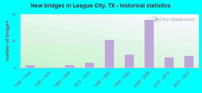
- New bridges - historical statistics
- 21940-1949
- 21960-1969
- 41970-1979
- 211980-1989
- 101990-1999
- 362000-2009
- 82010-2019
- 92020-2022
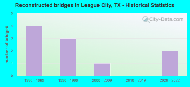
- Reconstructed bridges - Historical Statistics
- 41980-1989
- 31990-1999
- 12000-2009
- 02010-2019
- 22020-2022
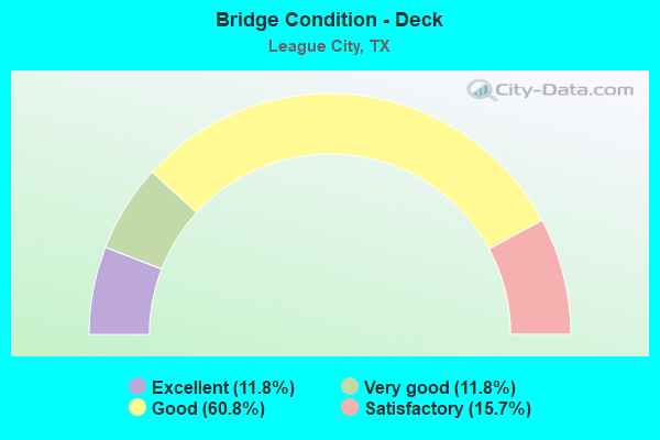
- Bridge Condition - Deck
- 11.8%Excellent
- 11.8%Very good
- 60.8%Good
- 15.7%Satisfactory
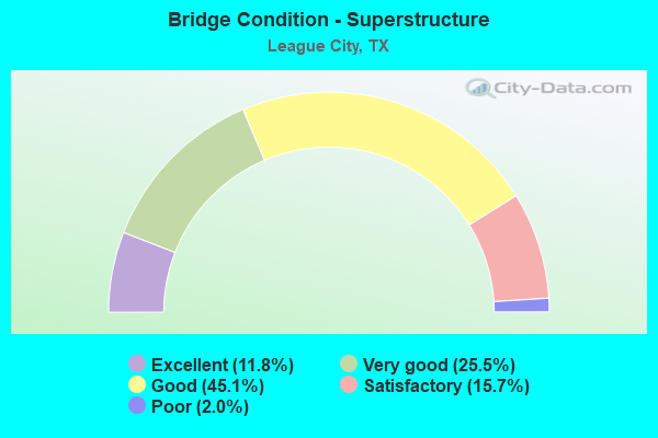
- Bridge Condition - Superstructure
- 11.8%Excellent
- 25.5%Very good
- 45.1%Good
- 15.7%Satisfactory
- 2.0%Poor
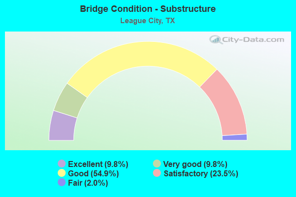
- Bridge Condition - Substructure
- 9.8%Excellent
- 9.8%Very good
- 54.9%Good
- 23.5%Satisfactory
- 2.0%Fair
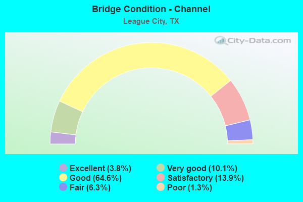
- Bridge Condition - Channel
- 3.8%Excellent
- 10.1%Very good
- 64.6%Good
- 13.9%Satisfactory
- 6.3%Fair
- 1.3%Poor
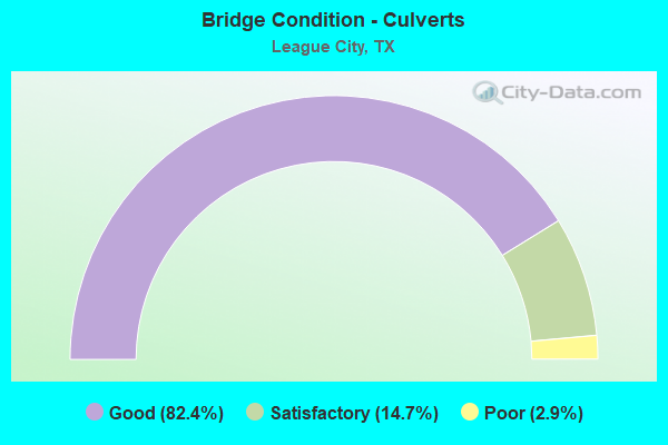
- Bridge Condition - Culverts
- 82.4%Good
- 14.7%Satisfactory
- 2.9%Poor
Find on map >> Show street view
Structure Number: 120850050004426, Location: 1.1 MI SE OF FM 518 (Lat: 29.488628, Lng: -95.105444), Route carried "under" structure: State highway 96, Year Built: 2009, Structure Length: 0. m, Average Daily Traffic: 5,000 (year 2013), Features Intersected: SH 96, Facility Carried by Structure: IH 45
Minimum Vertical Clearance: 5.18m (16.99ft), Kilometerpoint: 0.002, Lanes on structure: 6, Lanes under structure: 10, Material/Design: Prestressed concrete, Design/Construction: Stringer/Multi-beam, Length of Maximum Span: 39.3m (128.9ft)
Find on map >> Show street view
Structure Number: 120850050004453, Location: 1.40 MI NW of FM 517 (Lat: 29.465708, Lng: -95.090214), Route carried "under" structure: State highway 646, Year Built: 2020, Structure Length: 0. m, Average Daily Traffic: 5,460 (year 2013), Truck Traffic: 4%, Features Intersected: FM 646, Facility Carried by Structure: IH 45 NBML
Minimum Vertical Clearance: 5.03m (16.50ft), Kilometerpoint: 13.208, Lanes on structure: 5, Lanes under structure: 10, Material/Design: Prestressed concrete, Design/Construction: Stringer/Multi-beam, Length of Maximum Span: 37.8m (124.0ft)
Find on map >> Show street view
Structure Number: 120850050004454, Location: 1.40 MI NW of FM 517 (Lat: 29.466275, Lng: -95.091236), Route carried "under" structure: State highway 646, Year Built: 2020, Structure Length: 0. m, Average Daily Traffic: 115,900 (year 2016), Truck Traffic: 4%, Features Intersected: FM 646, Facility Carried by Structure: IH 45 SBML
Minimum Vertical Clearance: 5.03m (16.50ft), Kilometerpoint: 13.209, Lanes on structure: 5, Lanes under structure: 10, Material/Design: Prestressed concrete, Design/Construction: Stringer/Multi-beam, Length of Maximum Span: 37.8m (124.0ft)
Find on map >> Show street view
Structure Number: 120850050004469, Location: 2.91 MI NW of FM 646 (Lat: 29.503547, Lng: -95.114444), Route carried "under" structure: State highway 518, Year Built: 2020, Structure Length: 0. m, Average Daily Traffic: 144,300 (year 2010), Truck Traffic: 4%, Features Intersected: FM 518, Facility Carried by Structure: IH 45
Minimum Vertical Clearance: 5.21m (17.09ft), Kilometerpoint: 13.403, Lanes on structure: 10, Lanes under structure: 12, Material/Design: Prestressed concrete, Design/Construction: Stringer/Multi-beam, Length of Maximum Span: 44.2m (145.0ft)
Find on map >> Show street view
Structure Number: 120850097607044, Location: 1.8 MI E OF IH 45 (Lat: 29.494297, Lng: -95.077847), Route carried "under" structure: City street 96, Year Built: 2002, Structure Length: 0. m, Average Daily Traffic: 1,350 (year 2013), Features Intersected: UP RR & DICKINSON RD
Minimum Vertical Clearance: 8.21m (26.94ft), Kilometerpoint: 2.886, Lanes on structure: 2, Lanes under structure: 2, Material/Design: Prestressed concrete, Design/Construction: Stringer/Multi-beam, Length of Maximum Span: 39.0m (128.0ft)
Find on map >> Show street view
Structure Number: 120850097607045, Location: 1.8 MI E OF IH 45 (Lat: 29.494386, Lng: -95.077931), Route carried "under" structure: City street , Year Built: 2002, Structure Length: 0. m, Average Daily Traffic: 1,350 (year 2013), Features Intersected: UP RR & DICKINSON RD, Facility Carried by Structure: SH 96 WB
Minimum Vertical Clearance: 8.21m (26.94ft), Kilometerpoint: 2.886, Lanes on structure: 2, Lanes under structure: 2, Material/Design: Prestressed concrete, Design/Construction: Stringer/Multi-beam, Length of Maximum Span: 39.0m (128.0ft)
Find on map >> Show street view
Structure Number: 121020331201001, Location: 1.00 MI SE OF NASA RD 1 (Lat: 29.535025, Lng: -95.096139), Route carried "under" structure: State highway 270, Year Built: 1981, Structure Length: 0. m, Average Daily Traffic: 28,430 (year 0000), Features Intersected: CLEAR CREEK
Minimum Vertical Clearance: 30+ m (98+ ft), Kilometerpoint: 3.051, Lanes on structure: 7, Material/Design: Prestressed concrete, Design/Construction: Stringer/Multi-beam, Length of Maximum Span: 38.1m (125.0ft)