Bridge Statistics for Leander, Texas (TX)
Condition, Traffic, Stress, Structural Evaluation, Project Costs
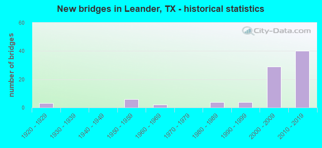
- New bridges - historical statistics
- 31920-1929
- 61950-1959
- 21960-1969
- 41980-1989
- 41990-1999
- 292000-2009
- 402010-2019
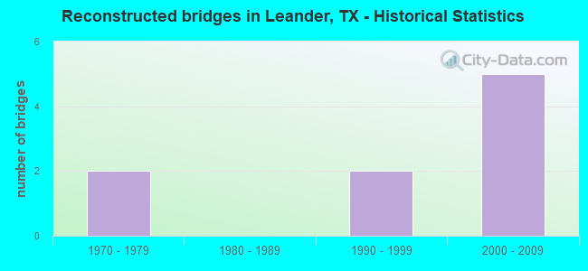
- Reconstructed bridges - Historical Statistics
- 21970-1979
- 01980-1989
- 21990-1999
- 52000-2009
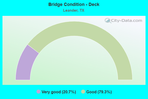
- Bridge Condition - Deck
- 20.7%Very good
- 79.3%Good
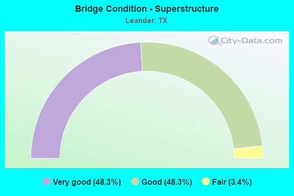
- Bridge Condition - Superstructure
- 48.3%Very good
- 48.3%Good
- 3.4%Fair
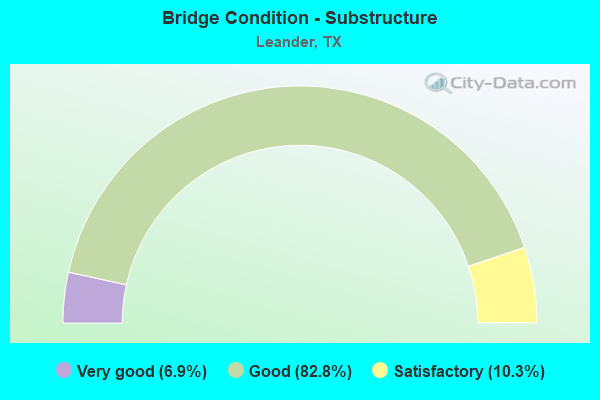
- Bridge Condition - Substructure
- 6.9%Very good
- 82.8%Good
- 10.3%Satisfactory
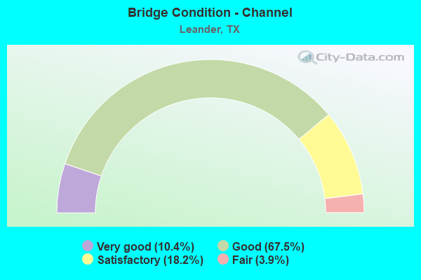
- Bridge Condition - Channel
- 10.4%Very good
- 67.5%Good
- 18.2%Satisfactory
- 3.9%Fair
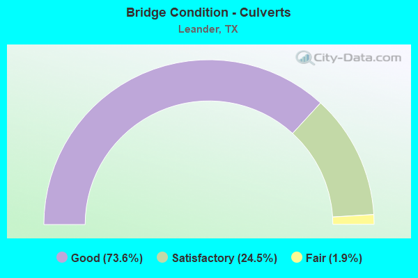
- Bridge Condition - Culverts
- 73.6%Good
- 24.5%Satisfactory
- 1.9%Fair
Find on map >> Show street view
Structure Number: 142270137801022, Location: 4.4 MI W OF US 183 (Lat: 30.519689, Lng: -97.896772), Route carried "on" structure: State highway 1431, Year Built: 1982, Status: Open, Structure Length: 1.37m (4.49ft), Average Daily Traffic: 19,825 (year 2020), Truck Traffic: 4%, Average Future Daily Traffic: 29,955 (year 2039), Design Load: HS 20, Features Intersected: BLOODY HOLLOW
Minimum Vertical Clearance: 30+ m (98+ ft), Kilometerpoint: 36.677, Lanes on structure: 4, Owner: State Highway Agency, Approaching Roadway Width: 15.9m (52.2ft), Skew: 1 degrees, Material/Design: Concrete, Design/Construction: Culvert, Number Of Spans In Main Unit: 4, Length of Maximum Span: 3.0m (9.8ft)
Condition: Channel: Satisfactory, Culverts: Satisfactory, Operating Rating: 39.9 metric tons, Method Used To Determine Operating Rating: Load Factor (LF), Inventory Rating: 23.6 metric tons, Method Used To Determine Inventory Rating: Load Factor (LF), Structural Evaluation: Somewhat better than minimum adequacy, Waterway Adequacy: Equal to present minimum criteria, Approach Roadway Alignment: Equal to present minimum criteria, Designated Inspection Frequency: Every 48 months, Inspection Date: Febuary 2021
Find on map >> Show street view
Structure Number: 142270AA1097001, Location: 0.2 MI W OF NAMELESS RD (Lat: 30.570558, Lng: -97.947606), Route carried "on" structure: County highway 206, Year Built: 1999, Status: Open, Structure Length: 4.11m (13.48ft), Average Daily Traffic: 2,996 (year 2020), Truck Traffic: 5%, Average Future Daily Traffic: 4,455 (year 2027), Features Intersected: BIG SANDY CREEK, Facility Carried by Structure: ROUND MOUNTAIN RD
Minimum Vertical Clearance: 30+ m (98+ ft), Kilometerpoint: 0.322, Lanes on structure: 2, Owner: County Highway Agency, Approaching Roadway Width: 7.9m (25.9ft), Material/Design: Prestressed concrete, Design/Construction: Box Beam or Girders - Multiple, Number Of Spans In Main Unit: 3, Length of Maximum Span: 13.7m (44.9ft), Curb-To-Curb Width: 10.5m (34.4ft), Out-to-Out Width: 11.1m (36.4ft)
Condition: Deck: Very good, Superstructure: Very good, Substructure: Good, Channel: Satisfactory, Operating Rating: 32.7 metric tons, Method Used To Determine Operating Rating: Field evaluation and documented engineering judgment, Inventory Rating: 24.5 metric tons, Method Used To Determine Inventory Rating: Field evaluation and documented engineering judgment, Structural Evaluation: Equal to present minimum criteria, Deck Geometry: Somewhat better than minimum adequacy, Waterway Adequacy: Better than present minimum criteria, Approach Roadway Alignment: Equal to present desirable criteria, Designated Inspection Frequency: Every 24 months, Inspection Date: April 2020, Deck Structure Type: Concrete Cast-file-Place, Wearing Surface/Protective System: Wearing Surface: Bituminous
Find on map >> Show street view
Structure Number: 142270AA1097002, Location: 1.0 MI NW OF NAMELESS RD (Lat: 30.580092, Lng: -97.945042), Route carried "on" structure: County highway 207, Year Built: 1958, Status: Open, Structure Length: 0.82m (2.69ft), Average Daily Traffic: 440 (year 2010), Average Future Daily Traffic: 570 (year 2027), Features Intersected: BINGHAM CREEK, Facility Carried by Structure: ROUND MOUNTAIN RD
Minimum Vertical Clearance: 30+ m (98+ ft), Kilometerpoint: 1.609, Lanes on structure: 2, Owner: County Highway Agency, Approaching Roadway Width: 6.7m (22.0ft), Skew: 3 degrees, Material/Design: Concrete, Design/Construction: Culvert, Number Of Spans In Main Unit: 2, Length of Maximum Span: 3.0m (9.8ft), Curb-To-Curb Width: 6.5m (21.3ft), Out-to-Out Width: 6.7m (22.0ft)
Condition: Channel: Good, Culverts: Satisfactory, Operating Rating: 32.7 metric tons, Method Used To Determine Operating Rating: Field evaluation and documented engineering judgment, Inventory Rating: 24.5 metric tons, Method Used To Determine Inventory Rating: Field evaluation and documented engineering judgment, Structural Evaluation: Equal to present minimum criteria, Deck Geometry: High priority of corrective action, Waterway Adequacy: Meets minimum limits, Approach Roadway Alignment: Equal to present desirable criteria, Length Of Structure Improvement: 0.82m (2.69ft), Designated Inspection Frequency: Every 24 months, Inspection Date: April 2020, Bridge Improvement Cost: $1,000, Total Project Cost: $1,000, Deck Structure Type: Concrete Cast-file-Place, Wearing Surface/Protective System: Wearing Surface: Bituminous
Find on map >> Show street view
Structure Number: 142270AA2208001, Location: 0.61 MI SW BIG SANDY DR (Lat: 30.562133, Lng: -97.954542), Route carried "on" structure: County highway 2208, Year Built: 1980, Status: Open, Structure Length: 0.79m (2.59ft), Average Daily Traffic: 100 (year 2020), Average Future Daily Traffic: 250 (year 2036), Features Intersected: DEWBERRY HOLLOW, Facility Carried by Structure: PECAN HOLLOW DR
Minimum Vertical Clearance: 30+ m (98+ ft), Kilometerpoint: 0.993, Lanes on structure: 2, Owner: County Highway Agency, Approaching Roadway Width: 5.2m (17.1ft), Material/Design: Concrete, Design/Construction: Culvert, Number Of Spans In Main Unit: 3, Length of Maximum Span: 2.4m (7.9ft), Curb-To-Curb Width: 7.7m (25.3ft), Out-to-Out Width: 8.1m (26.6ft)
Condition: Channel: Fair, Culverts: Satisfactory, Operating Rating: 32.7 metric tons, Method Used To Determine Operating Rating: Field evaluation and documented engineering judgment, Inventory Rating: 24.5 metric tons, Method Used To Determine Inventory Rating: Field evaluation and documented engineering judgment, Structural Evaluation: Equal to present minimum criteria, Deck Geometry: Equal to present minimum criteria, Waterway Adequacy: Better than present minimum criteria, Approach Roadway Alignment: Equal to present desirable criteria, Designated Inspection Frequency: Every 24 months, Inspection Date: April 2020, Deck Structure Type: Concrete Cast-file-Place, Wearing Surface/Protective System: Wearing Surface: Bituminous
Find on map >> Show street view
Structure Number: 14246000150822, Location: 7.40 MI N OF FM 972 (Lat: 30.825003, Lng: -97.604719), Route carried "on" structure: Interstate 35, Year Built: 1964, Year Reconstructed: 2003, Status: Open, Structure Length: 4.33m (14.21ft), Average Daily Traffic: 69,703 (year 2020), Truck Traffic: 28%, Average Future Daily Traffic: 109,645 (year 2039), Design Load: HS 20, Features Intersected: FM 487
Minimum Vertical Clearance: 30+ m (98+ ft), Kilometerpoint: 40.366, Lanes on structure: 6, Lanes under structure: 2, Base Highway Network: Yes, Owner: State Highway Agency, Approaching Roadway Width: 33.5m (109.9ft), Skew: 30 degrees, Material/Design: Prestressed concrete, Design/Construction: Stringer/Multi-beam, Number Of Spans In Main Unit: 3, Length of Maximum Span: 15.2m (49.9ft), Curb-To-Curb Width: 33.2m (108.9ft), Out-to-Out Width: 34.7m (113.8ft)
Condition: Deck: Good, Superstructure: Fair, Substructure: Satisfactory, Operating Rating: 54.4 metric tons, Method Used To Determine Operating Rating: Assigned ratings based on Allowable Stress Design (ASD) reported in metric tons, Inventory Rating: 32.7 metric tons, Method Used To Determine Inventory Rating: Assigned ratings based on Allowable Stress Design (ASD) reported in metric tons, Structural Evaluation: Somewhat better than minimum adequacy, Deck Geometry: Superior to present desirable criteria, Underclear: High priority of corrective action, Approach Roadway Alignment: Equal to present desirable criteria, Designated Inspection Frequency: Every 24 months, Inspection Date: Febuary 2021, Deck Structure Type: Concrete Cast-file-Place, Wearing Surface/Protective System: Wearing Surface: Bituminous
Find on map >> Show street view
Structure Number: 142460015104014, Location: 5.20 MI S OF SH 29 (Lat: 30.582269, Lng: -97.854217), Route carried "on" structure: US 183, Year Built: 1925, Year Reconstructed: 2012, Status: Open, Structure Length: 1.34m (4.40ft), Average Daily Traffic: 25,703 (year 2020), Truck Traffic: 5%, Average Future Daily Traffic: 2,814 (year 2039), Features Intersected: S FK OF BRUSHY CREEK
Minimum Vertical Clearance: 30+ m (98+ ft), Kilometerpoint: 29.437, Lanes on structure: 6, Base Highway Network: Yes, Owner: State Highway Agency, Approaching Roadway Width: 25.0m (82.0ft), Material/Design: Concrete, Design/Construction: Culvert, Number Of Spans In Main Unit: 5, Length of Maximum Span: 2.4m (7.9ft), Curb-To-Curb Width: 24.8m (81.4ft), Out-to-Out Width: 26.2m (86.0ft)
Condition: Channel: Satisfactory, Culverts: Satisfactory, Operating Rating: 32.7 metric tons, Method Used To Determine Operating Rating: Field evaluation and documented engineering judgment, Inventory Rating: 24.5 metric tons, Method Used To Determine Inventory Rating: Field evaluation and documented engineering judgment, Structural Evaluation: Equal to present minimum criteria, Deck Geometry: Somewhat better than minimum adequacy, Waterway Adequacy: Equal to present minimum criteria, Approach Roadway Alignment: Equal to present desirable criteria, Designated Inspection Frequency: Every 24 months, Inspection Date: Febuary 2021, Deck Structure Type: Concrete Cast-file-Place, Wearing Surface/Protective System: Wearing Surface: Bituminous
Find on map >> Show street view
Structure Number: 142460015104032, Location: 4.40 MI S OF SH 29 (Lat: 30.592144, Lng: -97.858775), Route carried "on" structure: US 183, Year Built: 1956, Year Reconstructed: 2007, Status: Open, Structure Length: 3.38m (11.09ft), Average Daily Traffic: 25,703 (year 2020), Truck Traffic: 5%, Average Future Daily Traffic: 28,314 (year 2039), Features Intersected: N FORK BRUSHY CREEK
Minimum Vertical Clearance: 30+ m (98+ ft), Kilometerpoint: 28.268, Lanes on structure: 5, Base Highway Network: Yes, Owner: State Highway Agency, Approaching Roadway Width: 21.3m (69.9ft), Skew: 4 degrees, Material/Design: Concrete, Design/Construction: Culvert, Number Of Spans In Main Unit: 9, Length of Maximum Span: 2.4m (7.9ft), Curb-To-Curb Width: 21.4m (70.2ft), Out-to-Out Width: 23.0m (75.5ft)
Condition: Channel: Good, Culverts: Satisfactory, Operating Rating: 32.7 metric tons, Method Used To Determine Operating Rating: Field evaluation and documented engineering judgment, Inventory Rating: 24.5 metric tons, Method Used To Determine Inventory Rating: Field evaluation and documented engineering judgment, Structural Evaluation: Equal to present minimum criteria, Deck Geometry: Somewhat better than minimum adequacy, Waterway Adequacy: Equal to present minimum criteria, Approach Roadway Alignment: Equal to present desirable criteria, Designated Inspection Frequency: Every 24 months, Inspection Date: Febuary 2021, Deck Structure Type: Concrete Cast-file-Place, Wearing Surface/Protective System: Wearing Surface: Bituminous
Find on map >> Show street view
Structure Number: 142460015104487, Location: 2.4 MI S OF SH 29 (Lat: 30.620464, Lng: -97.860033), Route carried "on" structure: ServiceUS 183, Year Built: 2010, Status: Open, Structure Length: 14.02m (46.00ft), Average Daily Traffic: 19,519 (year 2019), Truck Traffic: 7%, Average Future Daily Traffic: 23,423 (year 2039), Design Load: HL 93, Features Intersected: SOUTH SAN GABRIEL RIVER
Minimum Vertical Clearance: 30+ m (98+ ft), Kilometerpoint: 24.897, Lanes on structure: 2, Base Highway Network: Yes, Owner: State Highway Agency, Approaching Roadway Width: 13.4m (44.0ft), Material/Design: Prestressed concrete, Design/Construction: Stringer/Multi-beam, Number Of Spans In Main Unit: 4, Length of Maximum Span: 35.1m (115.2ft), Curb-To-Curb Width: 13.2m (43.3ft), Out-to-Out Width: 14.0m (45.9ft)
Condition: Deck: Good, Superstructure: Good, Substructure: Good, Channel: Good, Operating Rating: 54.4 metric tons, Method Used To Determine Operating Rating: Assigned ratings based on Load and Resistance Factor Design (LRFD) reported in metric tons, Inventory Rating: 32.7 metric tons, Method Used To Determine Inventory Rating: Assigned ratings based on Load and Resistance Factor Design (LRFD) reported in metric tons, Structural Evaluation: Better than present minimum criteria, Deck Geometry: Somewhat better than minimum adequacy, Waterway Adequacy: Superior to present desirable criteria, Approach Roadway Alignment: Equal to present desirable criteria, Designated Inspection Frequency: Every 24 months, Inspection Date: Febuary 2021, Deck Structure Type: Concrete Precast Panels
Find on map >> Show street view
Structure Number: 142460015104488, Location: 2.4 MI S OF SH 29 (Lat: 30.621464, Lng: -97.861694), Route carried "on" structure: US 183, Year Built: 2012, Status: Open, Structure Length: 14.02m (46.00ft), Average Daily Traffic: 19,925 (year 2020), Truck Traffic: 7%, Average Future Daily Traffic: 23,423 (year 2039), Design Load: HL 93, Features Intersected: S FRK SAN GABRIEL RIVER
Minimum Vertical Clearance: 30+ m (98+ ft), Kilometerpoint: 24.897, Lanes on structure: 3, Base Highway Network: Yes, Owner: State Highway Agency, Approaching Roadway Width: 15.2m (49.9ft), Material/Design: Prestressed concrete, Design/Construction: Stringer/Multi-beam, Number Of Spans In Main Unit: 4, Length of Maximum Span: 35.1m (115.2ft), Curb-To-Curb Width: 15.2m (49.9ft), Out-to-Out Width: 15.9m (52.2ft)
Condition: Deck: Good, Superstructure: Good, Substructure: Good, Channel: Good, Operating Rating: 54.4 metric tons, Method Used To Determine Operating Rating: Assigned ratings based on Load and Resistance Factor Design (LRFD) reported in metric tons, Inventory Rating: 32.7 metric tons, Method Used To Determine Inventory Rating: Assigned ratings based on Load and Resistance Factor Design (LRFD) reported in metric tons, Structural Evaluation: Better than present minimum criteria, Deck Geometry: Equal to present minimum criteria, Waterway Adequacy: Superior to present desirable criteria, Approach Roadway Alignment: Equal to present desirable criteria, Designated Inspection Frequency: Every 24 months, Inspection Date: Febuary 2021, Deck Structure Type: Concrete Precast Panels
Find on map >> Show street view
Structure Number: 142460015104491, Location: 1.9 MI S OF SH 29 (Lat: 30.628722, Lng: -97.865183), Route carried "on" structure: US 183, Year Built: 2012, Status: Open, Structure Length: 3.17m (10.40ft), Average Daily Traffic: 19,925 (year 2020), Truck Traffic: 11%, Average Future Daily Traffic: 17,380 (year 2033), Design Load: HL 93, Features Intersected: DRAW
Minimum Vertical Clearance: 30+ m (98+ ft), Kilometerpoint: 0.000, Lanes on structure: 4, Owner: State Highway Agency, Approaching Roadway Width: 17.4m (57.1ft), Skew: 4 degrees, Material/Design: Concrete, Design/Construction: Culvert, Number Of Spans In Main Unit: 7, Length of Maximum Span: 3.0m (9.8ft), Curb-To-Curb Width: 17.3m (56.8ft), Out-to-Out Width: 29.9m (98.1ft)
Condition: Channel: Good, Culverts: Good, Operating Rating: 44.4 metric tons, Method Used To Determine Operating Rating: Assigned ratings based on Load and Resistance Factor Design (LRFD) reported in metric tons, Inventory Rating: 32.7 metric tons, Method Used To Determine Inventory Rating: Assigned ratings based on Load and Resistance Factor Design (LRFD) reported in metric tons, Structural Evaluation: Better than present minimum criteria, Deck Geometry: Somewhat better than minimum adequacy, Waterway Adequacy: Better than present minimum criteria, Approach Roadway Alignment: Equal to present desirable criteria, Designated Inspection Frequency: Every 48 months, Inspection Date: January 2021, Deck Structure Type: Concrete Cast-file-Place, Wearing Surface/Protective System: Wearing Surface: Bituminous
Find on map >> Show street view
Structure Number: 142460015104492, Location: 1.9 MI S OF SH 29 (Lat: 30.628017, Lng: -97.864492), Route carried "on" structure: Ramp US 183, Year Built: 2012, Status: Open, Structure Length: 2.32m (7.61ft), Average Daily Traffic: 6,210 (year 2013), Truck Traffic: 11%, Average Future Daily Traffic: 8,690 (year 2033), Design Load: HL 93, Features Intersected: DRAW
Minimum Vertical Clearance: 30+ m (98+ ft), Kilometerpoint: 0.000, Lanes on structure: 2, Owner: State Highway Agency, Approaching Roadway Width: 10.1m (33.1ft), Skew: 1 degrees, Material/Design: Concrete, Design/Construction: Culvert, Number Of Spans In Main Unit: 7, Length of Maximum Span: 3.0m (9.8ft), Curb-To-Curb Width: 10.1m (33.1ft), Out-to-Out Width: 20.1m (65.9ft)
Condition: Channel: Very good, Culverts: Good, Operating Rating: 44.4 metric tons, Method Used To Determine Operating Rating: Assigned ratings based on Load and Resistance Factor Design (LRFD) reported in metric tons, Inventory Rating: 32.7 metric tons, Method Used To Determine Inventory Rating: Assigned ratings based on Load and Resistance Factor Design (LRFD) reported in metric tons, Structural Evaluation: Better than present minimum criteria, Deck Geometry: Equal to present minimum criteria, Waterway Adequacy: Better than present minimum criteria, Approach Roadway Alignment: Equal to present desirable criteria, Designated Inspection Frequency: Every 48 months, Inspection Date: January 2021, Deck Structure Type: Concrete Cast-file-Place, Wearing Surface/Protective System: Wearing Surface: Bituminous
Find on map >> Show street view
Structure Number: 142460015104493, Location: 1.9 MI S OF SH 29 (Lat: 30.627217, Lng: -97.863469), Route carried "on" structure: US 183, Year Built: 2012, Status: Open, Structure Length: 3.14m (10.30ft), Average Daily Traffic: 19,234 (year 2019), Truck Traffic: 11%, Average Future Daily Traffic: 8,690 (year 2033), Design Load: HL 93, Features Intersected: DRAW
Minimum Vertical Clearance: 30+ m (98+ ft), Kilometerpoint: 0.000, Lanes on structure: 3, Owner: State Highway Agency, Approaching Roadway Width: 12.2m (40.0ft), Skew: 4 degrees, Material/Design: Concrete, Design/Construction: Culvert, Number Of Spans In Main Unit: 7, Length of Maximum Span: 3.0m (9.8ft), Curb-To-Curb Width: 12.2m (40.0ft), Out-to-Out Width: 53.1m (174.2ft)
Condition: Channel: Good, Culverts: Good, Operating Rating: 44.4 metric tons, Method Used To Determine Operating Rating: Assigned ratings based on Load and Resistance Factor Design (LRFD) reported in metric tons, Inventory Rating: 32.7 metric tons, Method Used To Determine Inventory Rating: Assigned ratings based on Load and Resistance Factor Design (LRFD) reported in metric tons, Structural Evaluation: Better than present minimum criteria, Deck Geometry: Meets minimum limits, Waterway Adequacy: Better than present minimum criteria, Approach Roadway Alignment: Equal to present desirable criteria, Designated Inspection Frequency: Every 48 months, Inspection Date: January 2021, Deck Structure Type: Concrete Cast-file-Place, Wearing Surface/Protective System: Wearing Surface: Bituminous
Find on map >> Show street view
Structure Number: 142460015105015, Location: 5.9 MI S OF SH 29 (Lat: 30.571081, Lng: -97.849572), Route carried "on" structure: US 183, Year Built: 1927, Year Reconstructed: 1981, Status: Open, Structure Length: 1.68m (5.51ft), Average Daily Traffic: 25,780 (year 2020), Truck Traffic: 5%, Average Future Daily Traffic: 28,601 (year 2039), Features Intersected: MASON CREEK
Minimum Vertical Clearance: 30+ m (98+ ft), Kilometerpoint: 30.729, Lanes on structure: 5, Base Highway Network: Yes, Owner: State Highway Agency, Approaching Roadway Width: 18.9m (62.0ft), Material/Design: Concrete, Design/Construction: Culvert, Number Of Spans In Main Unit: 5, Length of Maximum Span: 3.0m (9.8ft), Curb-To-Curb Width: 18.9m (62.0ft), Out-to-Out Width: 23.2m (76.1ft)
Condition: Channel: Satisfactory, Culverts: Satisfactory, Operating Rating: 32.7 metric tons, Method Used To Determine Operating Rating: Field evaluation and documented engineering judgment, Inventory Rating: 24.5 metric tons, Method Used To Determine Inventory Rating: Field evaluation and documented engineering judgment, Structural Evaluation: Equal to present minimum criteria, Deck Geometry: Meets minimum limits, Waterway Adequacy: Equal to present minimum criteria, Approach Roadway Alignment: Equal to present desirable criteria, Designated Inspection Frequency: Every 24 months, Inspection Date: January 2021, Deck Structure Type: Concrete Cast-file-Place, Wearing Surface/Protective System: Wearing Surface: Bituminous
Find on map >> Show street view
Structure Number: 142460015105016, Location: 7.6 MI S OF SH 29 (Lat: 30.548339, Lng: -97.841814), Route carried "on" structure: US 183, Year Built: 1927, Year Reconstructed: 1981, Status: Open, Structure Length: 0.82m (2.69ft), Average Daily Traffic: 31,324 (year 2020), Truck Traffic: 9%, Average Future Daily Traffic: 32,170 (year 2033), Features Intersected: HOUGHTON CREEK
Minimum Vertical Clearance: 30+ m (98+ ft), Kilometerpoint: 33.408, Lanes on structure: 5, Base Highway Network: Yes, Owner: State Highway Agency, Approaching Roadway Width: 19.2m (63.0ft), Material/Design: Concrete, Design/Construction: Culvert, Number Of Spans In Main Unit: 6, Length of Maximum Span: 1.2m (3.9ft), Curb-To-Curb Width: 19.2m (63.0ft), Out-to-Out Width: 23.9m (78.4ft)
Condition: Channel: Satisfactory, Culverts: Satisfactory, Operating Rating: 32.7 metric tons, Method Used To Determine Operating Rating: Field evaluation and documented engineering judgment, Inventory Rating: 24.5 metric tons, Method Used To Determine Inventory Rating: Field evaluation and documented engineering judgment, Structural Evaluation: Equal to present minimum criteria, Deck Geometry: Meets minimum limits, Waterway Adequacy: Equal to present minimum criteria, Approach Roadway Alignment: Equal to present desirable criteria, Designated Inspection Frequency: Every 24 months, Inspection Date: January 2021, Deck Structure Type: Concrete Cast-file-Place, Wearing Surface/Protective System: Wearing Surface: Bituminous
Find on map >> Show street view
Structure Number: 142460210301001, Location: 0.75 MI E OF US 183 (Lat: 30.582300, Lng: -97.841317), Route carried "on" structure: State highway 2243, Year Built: 1956, Year Reconstructed: 2007, Status: Open, Structure Length: 2.47m (8.10ft), Average Daily Traffic: 6,543 (year 2020), Truck Traffic: 5%, Average Future Daily Traffic: 8,881 (year 2039), Features Intersected: BRUSHY CREEK
Minimum Vertical Clearance: 30+ m (98+ ft), Kilometerpoint: 17.267, Lanes on structure: 2, Owner: State Highway Agency, Approaching Roadway Width: 8.5m (27.9ft), Skew: 4 degrees, Material/Design: Concrete, Design/Construction: Culvert, Number Of Spans In Main Unit: 7, Length of Maximum Span: 2.4m (7.9ft), Curb-To-Curb Width: 8.4m (27.6ft), Out-to-Out Width: 11.9m (39.0ft)
Condition: Channel: Satisfactory, Culverts: Good, Operating Rating: 39.9 metric tons, Method Used To Determine Operating Rating: Load Factor (LF), Inventory Rating: 23.6 metric tons, Method Used To Determine Inventory Rating: Load Factor (LF), Structural Evaluation: Somewhat better than minimum adequacy, Deck Geometry: High priority of replacement, Waterway Adequacy: Equal to present minimum criteria, Approach Roadway Alignment: Equal to present desirable criteria, Length Of Structure Improvement: 2.47m (8.10ft), Designated Inspection Frequency: Every 24 months, Inspection Date: Febuary 2021, Bridge Improvement Cost: $5,000, Roadway Improvement Cost: $1,000, Total Project Cost: $6,000, Deck Structure Type: Concrete Cast-file-Place, Wearing Surface/Protective System: Wearing Surface: Bituminous
Find on map >> Show street view
Structure Number: 142460210301002, Location: 1.1 MI E OF TOLL 183A (Lat: 30.582028, Lng: -97.816378), Route carried "on" structure: State highway 2243, Year Built: 1956, Year Reconstructed: 2007, Status: Open, Structure Length: 0.94m (3.08ft), Average Daily Traffic: 6,543 (year 2020), Truck Traffic: 5%, Average Future Daily Traffic: 8,730 (year 2033), Features Intersected: DRAW
Minimum Vertical Clearance: 30+ m (98+ ft), Kilometerpoint: 19.748, Lanes on structure: 2, Owner: State Highway Agency, Approaching Roadway Width: 8.5m (27.9ft), Material/Design: Concrete, Design/Construction: Culvert, Number Of Spans In Main Unit: 4, Length of Maximum Span: 2.1m (6.9ft), Curb-To-Curb Width: 8.5m (27.9ft), Out-to-Out Width: 14.1m (46.3ft)
Condition: Channel: Good, Culverts: Good, Operating Rating: 39.9 metric tons, Method Used To Determine Operating Rating: Load Factor (LF), Inventory Rating: 23.6 metric tons, Method Used To Determine Inventory Rating: Load Factor (LF), Structural Evaluation: Somewhat better than minimum adequacy, Deck Geometry: High priority of replacement, Waterway Adequacy: Equal to present minimum criteria, Approach Roadway Alignment: Better than present minimum criteria, Length Of Structure Improvement: 0.94m (3.08ft), Designated Inspection Frequency: Every 24 months, Inspection Date: January 2021, Bridge Improvement Cost: $2,000, Roadway Improvement Cost: $1,000, Total Project Cost: $3,000, Deck Structure Type: Concrete Cast-file-Place, Wearing Surface/Protective System: Wearing Surface: Bituminous
Find on map >> Show street view
Structure Number: 142460210301003, Location: 1.5 MI E OF TOLL 183A (Lat: 30.585350, Lng: -97.811508), Route carried "on" structure: State highway 2243, Year Built: 1956, Status: Open, Structure Length: 1.13m (3.71ft), Average Daily Traffic: 6,543 (year 2020), Truck Traffic: 5%, Average Future Daily Traffic: 8,730 (year 2033), Features Intersected: DRAW
Minimum Vertical Clearance: 30+ m (98+ ft), Kilometerpoint: 20.353, Lanes on structure: 2, Owner: State Highway Agency, Approaching Roadway Width: 8.5m (27.9ft), Skew: 4 degrees, Material/Design: Concrete, Design/Construction: Culvert, Number Of Spans In Main Unit: 3, Length of Maximum Span: 2.4m (7.9ft), Curb-To-Curb Width: 7.3m (24.0ft), Out-to-Out Width: 8.9m (29.2ft)
Condition: Channel: Good, Culverts: Satisfactory, Operating Rating: 39.9 metric tons, Method Used To Determine Operating Rating: Load Factor (LF), Inventory Rating: 23.6 metric tons, Method Used To Determine Inventory Rating: Load Factor (LF), Structural Evaluation: Somewhat better than minimum adequacy, Deck Geometry: High priority of replacement, Waterway Adequacy: Equal to present minimum criteria, Approach Roadway Alignment: Better than present minimum criteria, Length Of Structure Improvement: 1.13m (3.71ft), Designated Inspection Frequency: Every 24 months, Inspection Date: January 2021, Bridge Improvement Cost: $2,000, Roadway Improvement Cost: $1,000, Total Project Cost: $3,000, Deck Structure Type: Concrete Cast-file-Place, Wearing Surface/Protective System: Wearing Surface: Bituminous
Find on map >> Show street view
Structure Number: 142460210301004, Location: 1.85 MI E OF TOLL 183A (Lat: 30.587606, Lng: -97.807939), Route carried "on" structure: State highway 2243, Year Built: 1956, Year Reconstructed: 2004, Status: Open, Structure Length: 0.79m (2.59ft), Average Daily Traffic: 6,543 (year 2020), Truck Traffic: 5%, Average Future Daily Traffic: 8,730 (year 2033), Features Intersected: DRAW
Minimum Vertical Clearance: 30+ m (98+ ft), Kilometerpoint: 20.801, Lanes on structure: 3, Owner: State Highway Agency, Approaching Roadway Width: 8.5m (27.9ft), Material/Design: Concrete, Design/Construction: Culvert, Number Of Spans In Main Unit: 3, Length of Maximum Span: 2.4m (7.9ft), Curb-To-Curb Width: 13.0m (42.7ft), Out-to-Out Width: 14.8m (48.6ft)
Condition: Channel: Good, Culverts: Satisfactory, Operating Rating: 39.9 metric tons, Method Used To Determine Operating Rating: Load Factor (LF), Inventory Rating: 23.6 metric tons, Method Used To Determine Inventory Rating: Load Factor (LF), Structural Evaluation: Somewhat better than minimum adequacy, Deck Geometry: Meets minimum limits, Waterway Adequacy: Equal to present minimum criteria, Approach Roadway Alignment: Better than present minimum criteria, Length Of Structure Improvement: 0.79m (2.59ft), Designated Inspection Frequency: Every 24 months, Inspection Date: January 2021, Bridge Improvement Cost: $11,000, Roadway Improvement Cost: $3,000, Total Project Cost: $14,000, Deck Structure Type: Concrete Cast-file-Place, Wearing Surface/Protective System: Wearing Surface: Bituminous
Find on map >> Show street view
Structure Number: 142460AA0147005, Location: 0.15 MI N OF VIEW DR (Lat: 30.648889, Lng: -97.806111), Route carried "on" structure: City street , Year Built: 2019, Status: Open, Structure Length: 1.37m (4.49ft), Average Daily Traffic: 50 (year 2020), Average Future Daily Traffic: 150 (year 2040), Features Intersected: Draw, Facility Carried by Structure: Deer Valley Drive
Minimum Vertical Clearance: 30+ m (98+ ft), Kilometerpoint: 0.214, Lanes on structure: 2, Owner: County Highway Agency, Approaching Roadway Width: 9.1m (29.9ft), Skew: 1 degrees, Material/Design: Concrete, Design/Construction: Culvert, Number Of Spans In Main Unit: 5, Length of Maximum Span: 2.4m (7.9ft), Curb-To-Curb Width: 9.2m (30.2ft), Out-to-Out Width: 21.0m (68.9ft)
Condition: Channel: Very good, Culverts: Good, Operating Rating: 32.7 metric tons, Method Used To Determine Operating Rating: Field evaluation and documented engineering judgment, Inventory Rating: 24.5 metric tons, Method Used To Determine Inventory Rating: Field evaluation and documented engineering judgment, Structural Evaluation: Equal to present minimum criteria, Deck Geometry: Better than present minimum criteria, Waterway Adequacy: Better than present minimum criteria, Approach Roadway Alignment: Equal to present desirable criteria, Designated Inspection Frequency: Every 24 months, Inspection Date: December 2021, Deck Structure Type: Concrete Cast-file-Place, Wearing Surface/Protective System: Wearing Surface: Bituminous
Find on map >> Show street view
Structure Number: 142460AA0147006, Location: AT SANDHILL PIPER ST (Lat: 30.633194, Lng: -97.847056), Route carried "on" structure: City street , Year Built: 2019, Status: Open, Structure Length: 1.43m (4.69ft), Average Daily Traffic: 250 (year 2020), Average Future Daily Traffic: 1,000 (year 2040), Design Load: HL 93, Features Intersected: Draw, Facility Carried by Structure: Blue Sage Drive
Minimum Vertical Clearance: 30+ m (98+ ft), Kilometerpoint: 0.362, Lanes on structure: 2, Owner: County Highway Agency, Approaching Roadway Width: 9.1m (29.9ft), Skew: 4 degrees, Material/Design: Concrete, Design/Construction: Culvert, Number Of Spans In Main Unit: 3, Length of Maximum Span: 3.0m (9.8ft), Curb or Sidewalk Widths: Left: 1.2m (3.9ft), Right: 1.2m (3.9ft)
Condition: Channel: Good, Culverts: Good, Operating Rating: 54.4 metric tons, Method Used To Determine Operating Rating: Field evaluation and documented engineering judgment, Inventory Rating: 32.7 metric tons, Method Used To Determine Inventory Rating: Assigned ratings based on Load and Resistance Factor Design (LRFD) reported in metric tons, Structural Evaluation: Better than present minimum criteria, Waterway Adequacy: Superior to present desirable criteria, Approach Roadway Alignment: Equal to present desirable criteria, Designated Inspection Frequency: Every 24 months, Inspection Date: December 2021
Find on map >> Show street view
Structure Number: 142460AA0179001, Location: 0.85 Mi E of Ronald Regan (Lat: 30.565178, Lng: -97.785842), Route carried "on" structure: County highway 179, Year Built: 2013, Status: Open, Structure Length: 4.88m (16.01ft), Average Daily Traffic: 4,000 (year 2018), Truck Traffic: 1%, Average Future Daily Traffic: 8,000 (year 2038), Features Intersected: Brushy Creek, Facility Carried by Structure: Journey Pkwy
Minimum Vertical Clearance: 30+ m (98+ ft), Kilometerpoint: 1.352, Lanes on structure: 2, Owner: County Highway Agency, Approaching Roadway Width: 14.6m (47.9ft), Material/Design: Prestressed concrete, Design/Construction: Stringer/Multi-beam, Number Of Spans In Main Unit: 2, Length of Maximum Span: 24.4m (80.1ft), Curb or Sidewalk Widths: Left: 1.7m (5.6ft), Right: 1.7m (5.6ft), Curb-To-Curb Width: 14.6m (47.9ft), Out-to-Out Width: 18.6m (61.0ft)
Condition: Deck: Good, Superstructure: Good, Substructure: Very good, Channel: Good, Operating Rating: 32.7 metric tons, Method Used To Determine Operating Rating: Field evaluation and documented engineering judgment, Inventory Rating: 24.5 metric tons, Method Used To Determine Inventory Rating: Field evaluation and documented engineering judgment, Structural Evaluation: Equal to present minimum criteria, Deck Geometry: Superior to present desirable criteria, Waterway Adequacy: Superior to present desirable criteria, Approach Roadway Alignment: Equal to present desirable criteria, Designated Inspection Frequency: Every 24 months, Inspection Date: December 2021, Deck Structure Type: Concrete Precast Panels
Find on map >> Show street view
Structure Number: 142460AA0179002, Location: 0.05 mi W of Sam Bass Rd (Lat: 30.567872, Lng: -97.777975), Route carried "on" structure: County highway 179, Year Built: 2013, Status: Open, Structure Length: 0.76m (2.49ft), Average Daily Traffic: 4,000 (year 2018), Average Future Daily Traffic: 8,000 (year 2038), Design Load: HL 93, Features Intersected: Draw, Facility Carried by Structure: Journey Pkwy
Minimum Vertical Clearance: 30+ m (98+ ft), Kilometerpoint: 2.173, Lanes on structure: 2, Owner: County Highway Agency, Approaching Roadway Width: 14.6m (47.9ft), Skew: 2 degrees, Material/Design: Concrete, Design/Construction: Culvert, Number Of Spans In Main Unit: 3, Length of Maximum Span: 2.1m (6.9ft), Curb or Sidewalk Widths: Left: 0.0m, Right: 1.8m (5.9ft), Curb-To-Curb Width: 14.9m (48.9ft), Out-to-Out Width: 24.4m (80.1ft)
Condition: Channel: Good, Culverts: Good, Operating Rating: 54.4 metric tons, Method Used To Determine Operating Rating: Assigned ratings based on Load and Resistance Factor Design (LRFD) reported in metric tons, Inventory Rating: 32.7 metric tons, Method Used To Determine Inventory Rating: Assigned ratings based on Load and Resistance Factor Design (LRFD) reported in metric tons, Structural Evaluation: Better than present minimum criteria, Deck Geometry: Superior to present desirable criteria, Waterway Adequacy: Superior to present desirable criteria, Approach Roadway Alignment: Equal to present desirable criteria, Designated Inspection Frequency: Every 24 months, Inspection Date: December 2021, Deck Structure Type: Concrete Precast Panels, Wearing Surface/Protective System: Wearing Surface: Bituminous
Find on map >> Show street view
Structure Number: 142460AA0602001, Location: 0.4 MI N OF SH 29 (Lat: 30.642789, Lng: -97.805025), Route carried "on" structure: County highway , Year Built: 2016, Status: Open, Structure Length: 2.65m (8.69ft), Average Daily Traffic: 30 (year 2017), Truck Traffic: 1%, Average Future Daily Traffic: 1 (year 1900), Design Load: HL 93, Features Intersected: Draw, Facility Carried by Structure: Creek Crossing Dr.
Minimum Vertical Clearance: 0.00m, Kilometerpoint: 0.644, Lanes on structure: 2, Owner: County Highway Agency, Approaching Roadway Width: 9.1m (29.9ft), Material/Design: Concrete, Design/Construction: Culvert, Number Of Spans In Main Unit: 10, Length of Maximum Span: 2.4m (7.9ft), Curb-To-Curb Width: 9.7m (31.8ft), Out-to-Out Width: 11.3m (37.1ft)
Condition: Channel: Good, Culverts: Good, Operating Rating: 54.4 metric tons, Method Used To Determine Operating Rating: Assigned ratings based on Load and Resistance Factor Design (LRFD) reported in metric tons, Inventory Rating: 32.7 metric tons, Method Used To Determine Inventory Rating: Assigned ratings based on Load and Resistance Factor Design (LRFD) reported in metric tons, Structural Evaluation: Better than present minimum criteria, Deck Geometry: Better than present minimum criteria, Waterway Adequacy: Superior to present desirable criteria, Approach Roadway Alignment: Equal to present desirable criteria, Designated Inspection Frequency: Every 24 months, Inspection Date: October 2021
Find on map >> Show street view
Structure Number: 142460AA0654003, Location: 2.1 MI N OF FM 1431 (Lat: 30.568847, Lng: -97.777589), Route carried "on" structure: County highway , Year Built: 2010, Status: Open, Structure Length: 1.07m (3.51ft), Average Daily Traffic: 1,870 (year 2020), Average Future Daily Traffic: 5,620 (year 2030), Design Load: HL 93, Features Intersected: BRUSHY CREEK BRANCH, Facility Carried by Structure: CR 175 (SAM BASS)
Minimum Vertical Clearance: 30+ m (98+ ft), Kilometerpoint: 13.358, Lanes on structure: 5, Owner: County Highway Agency, Approaching Roadway Width: 15.9m (52.2ft), Material/Design: Concrete, Design/Construction: Culvert, Number Of Spans In Main Unit: 4, Length of Maximum Span: 2.4m (7.9ft), Curb-To-Curb Width: 19.9m (65.3ft), Out-to-Out Width: 37.5m (123.0ft)
Condition: Channel: Good, Culverts: Good, Operating Rating: 54.4 metric tons, Method Used To Determine Operating Rating: Assigned ratings based on Load and Resistance Factor Design (LRFD) reported in metric tons, Inventory Rating: 32.7 metric tons, Method Used To Determine Inventory Rating: Assigned ratings based on Load and Resistance Factor Design (LRFD) reported in metric tons, Structural Evaluation: Better than present minimum criteria, Deck Geometry: Meets minimum limits, Waterway Adequacy: Superior to present desirable criteria, Approach Roadway Alignment: Equal to present desirable criteria, Designated Inspection Frequency: Every 24 months, Inspection Date: December 2021, Deck Structure Type: Concrete Cast-file-Place, Wearing Surface/Protective System: Wearing Surface: Bituminous
Find on map >> Show street view
Structure Number: 142460AA0705002, Location: 0.8 MI NE OF US 183 (Lat: 30.551281, Lng: -97.831200), Route carried "on" structure: County highway , Year Built: 1999, Status: Open, Structure Length: 1.68m (5.51ft), Average Daily Traffic: 3,350 (year 2020), Average Future Daily Traffic: 9,300 (year 2036), Features Intersected: DITCH, Facility Carried by Structure: BLOCKHOUSE DRIVE
Minimum Vertical Clearance: 30+ m (98+ ft), Kilometerpoint: 1.287, Lanes on structure: 2, Owner: County Highway Agency, Approaching Roadway Width: 13.4m (44.0ft), Skew: 1 degrees, Material/Design: Prestressed concrete, Design/Construction: Box Beam or Girders - Multiple, Number Of Spans In Main Unit: 1, Length of Maximum Span: 16.8m (55.1ft), Curb or Sidewalk Widths: Left: 1.6m (5.2ft), Right: 1.6m (5.2ft), Curb-To-Curb Width: 13.4m (44.0ft), Out-to-Out Width: 17.2m (56.4ft)
Condition: Deck: Good, Superstructure: Good, Substructure: Good, Channel: Good, Operating Rating: 32.7 metric tons, Method Used To Determine Operating Rating: Field evaluation and documented engineering judgment, Inventory Rating: 24.5 metric tons, Method Used To Determine Inventory Rating: Field evaluation and documented engineering judgment, Structural Evaluation: Equal to present minimum criteria, Deck Geometry: Better than present minimum criteria, Waterway Adequacy: Better than present minimum criteria, Approach Roadway Alignment: Equal to present desirable criteria, Designated Inspection Frequency: Every 24 months, Inspection Date: October 2021, Deck Structure Type: Concrete Cast-file-Place
Find on map >> Show street view
Structure Number: 142460AA0705003, Location: 1.30 MI NE OF US 183 (Lat: 30.554292, Lng: -97.825042), Route carried "on" structure: County highway , Year Built: 2001, Status: Open, Structure Length: 6.86m (22.51ft), Average Daily Traffic: 3,350 (year 2020), Truck Traffic: 3%, Average Future Daily Traffic: 4,690 (year 2040), Features Intersected: BLOCK HOUSE CREEK, Facility Carried by Structure: BLOCK HOUSE DR
Minimum Vertical Clearance: 30+ m (98+ ft), Kilometerpoint: 2.092, Lanes on structure: 2, Owner: County Highway Agency, Approaching Roadway Width: 13.4m (44.0ft), Material/Design: Prestressed concrete, Design/Construction: Stringer/Multi-beam, Number Of Spans In Main Unit: 3, Length of Maximum Span: 22.9m (75.1ft), Curb or Sidewalk Widths: Left: 1.8m (5.9ft), Right: 1.6m (5.2ft), Curb-To-Curb Width: 13.3m (43.6ft), Out-to-Out Width: 17.4m (57.1ft)
Condition: Deck: Good, Superstructure: Very good, Substructure: Good, Channel: Satisfactory, Operating Rating: 32.7 metric tons, Method Used To Determine Operating Rating: Field evaluation and documented engineering judgment, Inventory Rating: 24.5 metric tons, Method Used To Determine Inventory Rating: Field evaluation and documented engineering judgment, Structural Evaluation: Equal to present minimum criteria, Deck Geometry: Equal to present minimum criteria, Waterway Adequacy: Better than present minimum criteria, Approach Roadway Alignment: Equal to present desirable criteria, Designated Inspection Frequency: Every 24 months, Inspection Date: August 2021, Deck Structure Type: Concrete Precast Panels, Wearing Surface/Protective System: Wearing Surface: Monolithic Concrete
Find on map >> Show street view
Structure Number: 142460AA1201001, Location: 0.2 Miles North of SH 29 (Lat: 30.639694, Lng: -97.817875), Route carried "on" structure: County highway , Year Built: 2016, Status: Open, Structure Length: 1.31m (4.30ft), Average Daily Traffic: 500 (year 2016), Truck Traffic: 1%, Average Future Daily Traffic: 1 (year 1900), Design Load: HL 93, Features Intersected: DRAW, Facility Carried by Structure: KAUFFMAN LOOP
Minimum Vertical Clearance: 0.00m, Kilometerpoint: 0.322, Lanes on structure: 4, Owner: County Highway Agency, Approaching Roadway Width: 16.5m (54.1ft), Skew: 20 degrees, Material/Design: Concrete, Design/Construction: Culvert, Number Of Spans In Main Unit: 4, Length of Maximum Span: 3.0m (9.8ft), Curb-To-Curb Width: 16.5m (54.1ft), Out-to-Out Width: 32.9m (107.9ft)
Condition: Channel: Good, Culverts: Good, Operating Rating: 54.4 metric tons, Method Used To Determine Operating Rating: Assigned ratings based on Load and Resistance Factor Design (LRFD) reported in metric tons, Inventory Rating: 32.7 metric tons, Method Used To Determine Inventory Rating: Assigned ratings based on Load and Resistance Factor Design (LRFD) reported in metric tons, Structural Evaluation: Better than present minimum criteria, Deck Geometry: Meets minimum limits, Waterway Adequacy: Equal to present desirable criteria, Approach Roadway Alignment: Better than present minimum criteria, Designated Inspection Frequency: Every 24 months, Inspection Date: October 2021, Deck Structure Type: Concrete Cast-file-Place, Wearing Surface/Protective System: Wearing Surface: Bituminous
Find on map >> Show street view
Structure Number: 142460AA1270001, Location: 0.20 mi S of Journey Pkwy (Lat: 30.563814, Lng: -97.781817), Route carried "on" structure: County highway , Year Built: 2015, Status: Open, Structure Length: 2.13m (6.99ft), Average Daily Traffic: 300 (year 2018), Truck Traffic: 1%, Average Future Daily Traffic: 1 (year 1900), Features Intersected: Draw, Facility Carried by Structure: Pecan Creek Dr
Minimum Vertical Clearance: 30+ m (98+ ft), Kilometerpoint: 0.290, Lanes on structure: 2, Owner: County Highway Agency, Approaching Roadway Width: 9.1m (29.9ft), Skew: 3 degrees, Material/Design: Concrete, Design/Construction: Culvert, Number Of Spans In Main Unit: 7, Length of Maximum Span: 2.7m (8.9ft), Curb or Sidewalk Widths: Left: 1.2m (3.9ft), Right: 1.2m (3.9ft)
Condition: Channel: Good, Culverts: Good, Operating Rating: 32.7 metric tons, Method Used To Determine Operating Rating: Field evaluation and documented engineering judgment, Inventory Rating: 24.5 metric tons, Method Used To Determine Inventory Rating: Field evaluation and documented engineering judgment, Structural Evaluation: Equal to present minimum criteria, Waterway Adequacy: Superior to present desirable criteria, Approach Roadway Alignment: Equal to present desirable criteria, Designated Inspection Frequency: Every 24 months, Inspection Date: December 2021
Find on map >> Show street view
Structure Number: 142460AA1300008, Location: 0.05 MI N OF SH 29 (Lat: 30.638044, Lng: -97.828897), Route carried "on" structure: County highway , Year Built: 2007, Status: Open, Structure Length: 0.88m (2.89ft), Average Daily Traffic: 2,399 (year 2020), Truck Traffic: 3%, Average Future Daily Traffic: 3,358 (year 2040), Features Intersected: DRAW, Facility Carried by Structure: RONALD REAGAN SB
Minimum Vertical Clearance: 30+ m (98+ ft), Kilometerpoint: 0.080, Lanes on structure: 4, Owner: County Highway Agency, Approaching Roadway Width: 18.3m (60.0ft), Material/Design: Concrete, Design/Construction: Culvert, Number Of Spans In Main Unit: 5, Length of Maximum Span: 1.5m (4.9ft)
Condition: Channel: Fair, Culverts: Good, Operating Rating: 32.7 metric tons, Method Used To Determine Operating Rating: No rating analysis performed, Inventory Rating: 24.5 metric tons, Method Used To Determine Inventory Rating: No rating analysis performed, Structural Evaluation: Equal to present minimum criteria, Waterway Adequacy: Better than present minimum criteria, Approach Roadway Alignment: Equal to present desirable criteria, Designated Inspection Frequency: Every 24 months, Inspection Date: August 2021
Find on map >> Show street view
Structure Number: 142460AA1300009, Location: 0.05 MI N OF SH 29 (Lat: 30.638033, Lng: -97.827939), Route carried "on" structure: County highway , Year Built: 2007, Status: Open, Structure Length: 1.01m (3.31ft), Average Daily Traffic: 2,399 (year 2020), Truck Traffic: 3%, Average Future Daily Traffic: 3,358 (year 2040), Features Intersected: DRAW, Facility Carried by Structure: RONALD REAGAN NB
Minimum Vertical Clearance: 30+ m (98+ ft), Kilometerpoint: 0.080, Lanes on structure: 2, Owner: County Highway Agency, Approaching Roadway Width: 11.3m (37.1ft), Skew: 3 degrees, Material/Design: Concrete, Design/Construction: Culvert, Number Of Spans In Main Unit: 5, Length of Maximum Span: 1.5m (4.9ft)
Condition: Channel: Good, Culverts: Good, Operating Rating: 32.7 metric tons, Method Used To Determine Operating Rating: No rating analysis performed, Inventory Rating: 24.5 metric tons, Method Used To Determine Inventory Rating: No rating analysis performed, Structural Evaluation: Equal to present minimum criteria, Waterway Adequacy: Better than present minimum criteria, Approach Roadway Alignment: Equal to present desirable criteria, Designated Inspection Frequency: Every 24 months, Inspection Date: August 2021
Find on map >> Show street view
Structure Number: 142460AA3527001, Location: 0.3 MI E OF US 183 (Lat: 30.629197, Lng: -97.859678), Route carried "on" structure: County highway , Year Built: 2019, Status: Open, Structure Length: 1.59m (5.22ft), Average Daily Traffic: 100 (year 2019), Average Future Daily Traffic: 398 (year 2038), Design Load: HL 93, Features Intersected: DRAW, Facility Carried by Structure: LARKSPUR PARK BLVD
Minimum Vertical Clearance: 30+ m (98+ ft), Kilometerpoint: 0.000, Lanes on structure: 2, Owner: County Highway Agency, Approaching Roadway Width: 8.2m (26.9ft), Skew: 3 degrees, Material/Design: Concrete, Design/Construction: Culvert, Number Of Spans In Main Unit: 4, Length of Maximum Span: 3.7m (12.1ft)
Condition: Channel: Good, Culverts: Good, Operating Rating: 54.4 metric tons, Method Used To Determine Operating Rating: Assigned ratings based on Load and Resistance Factor Design (LRFD) reported in metric tons, Inventory Rating: 32.7 metric tons, Method Used To Determine Inventory Rating: Assigned ratings based on Load and Resistance Factor Design (LRFD) reported in metric tons, Structural Evaluation: Better than present minimum criteria, Waterway Adequacy: Better than present minimum criteria, Approach Roadway Alignment: Equal to present desirable criteria, Designated Inspection Frequency: Every 24 months, Inspection Date: October 2021
Find on map >> Show street view
Structure Number: 142460AA4540001, Location: 0.30 mi E of US 183 (Lat: 30.629228, Lng: -97.859675), Route carried "on" structure: County highway , Year Built: 2017, Status: Open, Structure Length: 1.65m (5.41ft), Average Daily Traffic: 300 (year 2018), Truck Traffic: 1%, Average Future Daily Traffic: 1,500 (year 2038), Features Intersected: Draw, Facility Carried by Structure: Larkspur Lake Blvd
Minimum Vertical Clearance: 30+ m (98+ ft), Kilometerpoint: 0.467, Lanes on structure: 2, Owner: County Highway Agency, Approaching Roadway Width: 8.2m (26.9ft), Skew: 9 degrees, Material/Design: Concrete, Design/Construction: Culvert, Number Of Spans In Main Unit: 4, Length of Maximum Span: 4.0m (13.1ft)
Condition: Channel: Very good, Culverts: Good, Operating Rating: 32.7 metric tons, Method Used To Determine Operating Rating: Field evaluation and documented engineering judgment, Inventory Rating: 24.5 metric tons, Method Used To Determine Inventory Rating: Field evaluation and documented engineering judgment, Structural Evaluation: Equal to present minimum criteria, Waterway Adequacy: Superior to present desirable criteria, Approach Roadway Alignment: Equal to present desirable criteria, Designated Inspection Frequency: Every 24 months, Inspection Date: December 2021
Find on map >> Show street view
Structure Number: 142460AA4540002, Location: 1.1 MI E OF US 183 (Lat: 30.626133, Lng: -97.847194), Route carried "on" structure: City street , Year Built: 2019, Status: Open, Structure Length: 0.94m (3.08ft), Average Daily Traffic: 300 (year 2020), Average Future Daily Traffic: 3,000 (year 2040), Design Load: HL 93, Features Intersected: Draw, Facility Carried by Structure: Larkspur Park Blvd
Minimum Vertical Clearance: 30+ m (98+ ft), Kilometerpoint: 1.802, Lanes on structure: 2, Owner: County Highway Agency, Approaching Roadway Width: 8.5m (27.9ft), Skew: 1 degrees, Material/Design: Concrete, Design/Construction: Culvert, Number Of Spans In Main Unit: 4, Length of Maximum Span: 2.4m (7.9ft), Curb or Sidewalk Widths: Left: 1.8m (5.9ft), Right: 0.0m
Condition: Channel: Good, Culverts: Good, Operating Rating: 54.4 metric tons, Method Used To Determine Operating Rating: Assigned ratings based on Load and Resistance Factor Design (LRFD) reported in metric tons, Inventory Rating: 32.7 metric tons, Method Used To Determine Inventory Rating: Assigned ratings based on Load and Resistance Factor Design (LRFD) reported in metric tons, Structural Evaluation: Better than present minimum criteria, Waterway Adequacy: Superior to present desirable criteria, Approach Roadway Alignment: Equal to present desirable criteria, Designated Inspection Frequency: Every 24 months, Inspection Date: December 2021
Find on map >> Show street view
Structure Number: 142460AA8650001, Location: 0.14 Mi S of Journey Pkwy (Lat: 30.564939, Lng: -97.780447), Route carried "on" structure: County highway , Year Built: 2016, Status: Open, Structure Length: 1.49m (4.89ft), Average Daily Traffic: 150 (year 2018), Truck Traffic: 1%, Average Future Daily Traffic: 180 (year 2038), Features Intersected: Draw, Facility Carried by Structure: Echo Park Dr
Minimum Vertical Clearance: 30+ m (98+ ft), Kilometerpoint: 0.225, Lanes on structure: 2, Owner: County Highway Agency, Approaching Roadway Width: 9.1m (29.9ft), Material/Design: Concrete, Design/Construction: Culvert, Number Of Spans In Main Unit: 5, Length of Maximum Span: 2.7m (8.9ft), Curb or Sidewalk Widths: Left: 1.2m (3.9ft), Right: 1.2m (3.9ft)
Condition: Channel: Good, Culverts: Good, Operating Rating: 32.7 metric tons, Method Used To Determine Operating Rating: Field evaluation and documented engineering judgment, Inventory Rating: 24.5 metric tons, Method Used To Determine Inventory Rating: Field evaluation and documented engineering judgment, Structural Evaluation: Equal to present minimum criteria, Waterway Adequacy: Better than present minimum criteria, Approach Roadway Alignment: Equal to present desirable criteria, Designated Inspection Frequency: Every 24 months, Inspection Date: December 2021
Find on map >> Show street view
Structure Number: 142460AA8780001, Location: 0.45 MI NE OF KAUFFMAN (Lat: 30.649300, Lng: -97.819219), Route carried "on" structure: County highway , Year Built: 2018, Status: Open, Structure Length: 0.88m (2.89ft), Average Daily Traffic: 100 (year 2018), Truck Traffic: 1%, Average Future Daily Traffic: 1,000 (year 2038), Design Load: HL 93, Features Intersected: Draw, Facility Carried by Structure: Morningstar Blvd
Minimum Vertical Clearance: 30+ m (98+ ft), Kilometerpoint: 0.724, Lanes on structure: 2, Owner: County Highway Agency, Approaching Roadway Width: 14.6m (47.9ft), Material/Design: Concrete, Design/Construction: Culvert, Number Of Spans In Main Unit: 3, Length of Maximum Span: 2.4m (7.9ft), Curb or Sidewalk Widths: Left: 1.2m (3.9ft), Right: 1.2m (3.9ft)
Condition: Channel: Very good, Culverts: Good, Operating Rating: 54.4 metric tons, Method Used To Determine Operating Rating: Assigned ratings based on Load and Resistance Factor Design (LRFD) reported in metric tons, Inventory Rating: 32.7 metric tons, Method Used To Determine Inventory Rating: Assigned ratings based on Load and Resistance Factor Design (LRFD) reported in metric tons, Structural Evaluation: Better than present minimum criteria, Waterway Adequacy: Superior to present desirable criteria, Approach Roadway Alignment: Equal to present desirable criteria, Designated Inspection Frequency: Every 24 months, Inspection Date: December 2021
Find on map >> Show street view
Structure Number: 142460H00030001, Location: 0.20 MI W US 183 (Lat: 30.579908, Lng: -97.857058), Route carried "on" structure: State highway 30, Year Built: 1967, Status: Open, Structure Length: 0.85m (2.79ft), Average Daily Traffic: 1,500 (year 2020), Truck Traffic: 6%, Average Future Daily Traffic: 1,000 (year 2030), Design Load: HS 20, Features Intersected: S FK BRUSHY CREEK, Facility Carried by Structure: W BROADE ST
Minimum Vertical Clearance: 30+ m (98+ ft), Kilometerpoint: 6.397, Lanes on structure: 2, Owner: City or Municipal Highway Agency, Approaching Roadway Width: 7.3m (24.0ft), Skew: 1 degrees, Material/Design: Concrete, Design/Construction: Culvert, Number Of Spans In Main Unit: 4, Length of Maximum Span: 1.8m (5.9ft)
Condition: Channel: Good, Culverts: Good, Operating Rating: 39.9 metric tons, Method Used To Determine Operating Rating: Load Factor (LF), Inventory Rating: 23.6 metric tons, Method Used To Determine Inventory Rating: Load Factor (LF), Structural Evaluation: Equal to present minimum criteria, Waterway Adequacy: Better than present minimum criteria, Approach Roadway Alignment: Better than present minimum criteria, Length Of Structure Improvement: 0.85m (2.79ft), Designated Inspection Frequency: Every 24 months, Inspection Date: November 2021
Find on map >> Show street view
Structure Number: 142460H00030002, Location: 0.07 Mi S of San Gabriel (Lat: 30.591983, Lng: -97.863350), Route carried "on" structure: County highway , Year Built: 2015, Status: Open, Structure Length: 1.37m (4.49ft), Average Daily Traffic: 1,200 (year 2018), Truck Traffic: 1%, Average Future Daily Traffic: 1 (year 1900), Design Load: HL 93, Features Intersected: North Fork Brushy Creek, Facility Carried by Structure: W Broade St
Minimum Vertical Clearance: 30+ m (98+ ft), Kilometerpoint: 0.113, Lanes on structure: 2, Owner: City or Municipal Highway Agency, Approaching Roadway Width: 12.2m (40.0ft), Skew: 3 degrees, Material/Design: Concrete, Design/Construction: Culvert, Number Of Spans In Main Unit: 3, Length of Maximum Span: 4.0m (13.1ft), Curb or Sidewalk Widths: Left: 1.8m (5.9ft), Right: 2.4m (7.9ft)
Condition: Channel: Good, Culverts: Good, Operating Rating: 54.4 metric tons, Method Used To Determine Operating Rating: Assigned ratings based on Load and Resistance Factor Design (LRFD) reported in metric tons, Inventory Rating: 32.7 metric tons, Method Used To Determine Inventory Rating: Assigned ratings based on Load and Resistance Factor Design (LRFD) reported in metric tons, Structural Evaluation: Better than present minimum criteria, Waterway Adequacy: Superior to present desirable criteria, Approach Roadway Alignment: Equal to present desirable criteria, Designated Inspection Frequency: Every 24 months, Inspection Date: November 2021
Find on map >> Show street view
Structure Number: 142460H00096001, Location: 0.4 MI E OF LAKELINE BLVD (Lat: 30.535278, Lng: -97.853797), Route carried "on" structure: City street , Year Built: 2003, Status: Open, Structure Length: 0.88m (2.89ft), Average Daily Traffic: 250 (year 2020), Average Future Daily Traffic: 275 (year 2040), Design Load: HS 20, Features Intersected: DRAINAGE DITCH, Facility Carried by Structure: LHS ACCESS RD
Minimum Vertical Clearance: 30+ m (98+ ft), Kilometerpoint: 0.644, Lanes on structure: 2, Owner: City or Municipal Highway Agency, Approaching Roadway Width: 9.1m (29.9ft), Material/Design: Concrete, Design/Construction: Culvert, Number Of Spans In Main Unit: 3, Length of Maximum Span: 2.4m (7.9ft), Curb or Sidewalk Widths: Left: 1.7m (5.6ft), Right: 2.4m (7.9ft), Curb-To-Curb Width: 9.1m (29.9ft), Out-to-Out Width: 14.0m (45.9ft)
Condition: Channel: Good, Culverts: Satisfactory, Operating Rating: 44.4 metric tons, Method Used To Determine Operating Rating: Assigned rating based on Load Factor Design (LFD) reported in metric tons, Inventory Rating: 32.7 metric tons, Method Used To Determine Inventory Rating: Assigned rating based on Load Factor Design (LFD) reported in metric tons, Structural Evaluation: Equal to present minimum criteria, Deck Geometry: Equal to present minimum criteria, Waterway Adequacy: Better than present minimum criteria, Approach Roadway Alignment: Equal to present desirable criteria, Designated Inspection Frequency: Every 24 months, Inspection Date: August 2021
Find on map >> Show street view
Structure Number: 142460H00175001, Location: 0.40 MI S OF MUNICIPAL DR (Lat: 30.568803, Lng: -97.853300), Route carried "on" structure: City street , Year Built: 2004, Status: Open, Structure Length: 3.69m (12.11ft), Average Daily Traffic: 3,530 (year 2010), Average Future Daily Traffic: 5,650 (year 2030), Features Intersected: MASON CREEK, Facility Carried by Structure: S WEST DR
Minimum Vertical Clearance: 30+ m (98+ ft), Kilometerpoint: 0.644, Lanes on structure: 2, Owner: City or Municipal Highway Agency, Approaching Roadway Width: 13.4m (44.0ft), Skew: 4 degrees, Material/Design: Concrete, Design/Construction: Culvert, Number Of Spans In Main Unit: 8, Length of Maximum Span: 3.0m (9.8ft), Curb or Sidewalk Widths: Left: 1.5m (4.9ft), Right: 1.5m (4.9ft), Curb-To-Curb Width: 13.4m (44.0ft), Out-to-Out Width: 17.1m (56.1ft)
Condition: Channel: Satisfactory, Culverts: Good, Operating Rating: 32.7 metric tons, Method Used To Determine Operating Rating: Field evaluation and documented engineering judgment, Inventory Rating: 24.5 metric tons, Method Used To Determine Inventory Rating: Field evaluation and documented engineering judgment, Structural Evaluation: Equal to present minimum criteria, Deck Geometry: Better than present minimum criteria, Waterway Adequacy: Better than present minimum criteria, Approach Roadway Alignment: Better than present minimum criteria, Designated Inspection Frequency: Every 24 months, Inspection Date: November 2021, Deck Structure Type: Concrete Cast-file-Place, Wearing Surface/Protective System: Wearing Surface: Bituminous
Find on map >> Show street view
Structure Number: 142460H00210001, Location: 0.20 MI E OF US 183 (Lat: 30.558800, Lng: -97.840939), Route carried "on" structure: City street , Year Built: 2008, Status: Open, Structure Length: 1.46m (4.79ft), Average Daily Traffic: 12,000 (year 2018), Truck Traffic: 1%, Average Future Daily Traffic: 15,000 (year 2038), Design Load: HS 20, Features Intersected: DRAINAGE DITCH, Facility Carried by Structure: CRYSTAL FALLS PKWY
Minimum Vertical Clearance: 30+ m (98+ ft), Kilometerpoint: 0.306, Lanes on structure: 4, Owner: City or Municipal Highway Agency, Approaching Roadway Width: 18.9m (62.0ft), Skew: 4 degrees, Material/Design: Concrete, Design/Construction: Culvert, Number Of Spans In Main Unit: 1, Number Of Approach Spans: 2, Length of Maximum Span: 5.2m (17.1ft), Curb or Sidewalk Widths: Left: 2.6m (8.5ft), Right: 1.8m (5.9ft)
Condition: Channel: Good, Culverts: Good, Operating Rating: 54.4 metric tons, Method Used To Determine Operating Rating: Assigned rating based on Load Factor Design (LFD) reported in metric tons, Inventory Rating: 32.7 metric tons, Method Used To Determine Inventory Rating: Assigned rating based on Load Factor Design (LFD) reported in metric tons, Structural Evaluation: Better than present minimum criteria, Waterway Adequacy: Superior to present desirable criteria, Approach Roadway Alignment: Equal to present desirable criteria, Designated Inspection Frequency: Every 24 months, Inspection Date: November 2021
Find on map >> Show street view
Structure Number: 142460H00265001, Location: 0.3 MI S OF FM 2243 (Lat: 30.576706, Lng: -97.845678), Route carried "on" structure: County highway 273, Year Built: 1990, Status: Open, Structure Length: 1.89m (6.20ft), Average Daily Traffic: 1,480 (year 2010), Truck Traffic: 2%, Average Future Daily Traffic: 2,370 (year 2030), Features Intersected: MASON CREEK, Facility Carried by Structure: Horizon Park Blvd
Minimum Vertical Clearance: 30+ m (98+ ft), Kilometerpoint: 0.563, Lanes on structure: 2, Owner: City or Municipal Highway Agency, Approaching Roadway Width: 7.9m (25.9ft), Material/Design: Steel, Design/Construction: Stringer/Multi-beam, Number Of Spans In Main Unit: 1, Length of Maximum Span: 18.3m (60.0ft), Curb-To-Curb Width: 7.9m (25.9ft), Out-to-Out Width: 8.5m (27.9ft)
Condition: Deck: Good, Superstructure: Good, Substructure: Satisfactory, Channel: Good, Operating Rating: 51.7 metric tons, Method Used To Determine Operating Rating: Load Factor (LF), Inventory Rating: 30.8 metric tons, Method Used To Determine Inventory Rating: Load Factor (LF), Structural Evaluation: Equal to present minimum criteria, Deck Geometry: Meets minimum limits, Waterway Adequacy: Better than present minimum criteria, Approach Roadway Alignment: Equal to present desirable criteria, Designated Inspection Frequency: Every 24 months, Inspection Date: November 2021, Deck Structure Type: Concrete Cast-file-Place, Wearing Surface/Protective System: Wearing Surface: Bituminous
Find on map >> Show street view
Structure Number: 142460H00265002, Location: 0.17 MI N OF RM 2243 (Lat: 30.582303, Lng: -97.849008), Route carried "on" structure: City street 273, Year Built: 2013, Status: Open, Structure Length: 5.73m (18.80ft), Average Daily Traffic: 1,937 (year 2020), Truck Traffic: 3%, Average Future Daily Traffic: 2,712 (year 2040), Features Intersected: SOUTH FORK BRUSHY CREEK
Minimum Vertical Clearance: 30+ m (98+ ft), Kilometerpoint: 2.720, Lanes on structure: 4, Owner: City or Municipal Highway Agency, Approaching Roadway Width: 13.4m (44.0ft), Material/Design: Concrete, Design/Construction: Arch - Deck, Number Of Spans In Main Unit: 4, Length of Maximum Span: 10.4m (34.1ft), Curb or Sidewalk Widths: Left: 2.9m (9.5ft), Right: 3.0m (9.8ft), Curb-To-Curb Width: 13.4m (44.0ft), Out-to-Out Width: 20.1m (65.9ft)
Condition: Deck: Very good, Superstructure: Very good, Substructure: Good, Channel: Good, Operating Rating: 32.7 metric tons, Method Used To Determine Operating Rating: Field evaluation and documented engineering judgment, Inventory Rating: 24.5 metric tons, Method Used To Determine Inventory Rating: Field evaluation and documented engineering judgment, Structural Evaluation: Equal to present minimum criteria, Deck Geometry: High priority of replacement, Waterway Adequacy: Superior to present desirable criteria, Approach Roadway Alignment: Equal to present desirable criteria, Designated Inspection Frequency: Every 24 months, Inspection Date: August 2021, Deck Structure Type: Concrete Precast Panels, Wearing Surface/Protective System: Wearing Surface: Bituminous
Find on map >> Show street view
Structure Number: 142460H00265003, Location: 0.43 MI N of RM 2243 (Lat: 30.587514, Lng: -97.852114), Route carried "on" structure: City street 273, Year Built: 2013, Status: Open, Structure Length: 4.18m (13.71ft), Average Daily Traffic: 1,937 (year 2020), Truck Traffic: 3%, Average Future Daily Traffic: 2,712 (year 2040), Features Intersected: NORTH FORK BRUSHY CREEK
Minimum Vertical Clearance: 30+ m (98+ ft), Kilometerpoint: 3.138, Lanes on structure: 4, Owner: City or Municipal Highway Agency, Approaching Roadway Width: 13.4m (44.0ft), Material/Design: Concrete, Design/Construction: Arch - Deck, Number Of Spans In Main Unit: 4, Length of Maximum Span: 10.4m (34.1ft), Curb or Sidewalk Widths: Left: 2.9m (9.5ft), Right: 3.1m (10.2ft), Curb-To-Curb Width: 13.4m (44.0ft), Out-to-Out Width: 20.1m (65.9ft)
Condition: Deck: Very good, Superstructure: Very good, Substructure: Good, Channel: Good, Operating Rating: 32.7 metric tons, Method Used To Determine Operating Rating: Field evaluation and documented engineering judgment, Inventory Rating: 24.5 metric tons, Method Used To Determine Inventory Rating: Field evaluation and documented engineering judgment, Structural Evaluation: Equal to present minimum criteria, Deck Geometry: High priority of replacement, Waterway Adequacy: Superior to present desirable criteria, Approach Roadway Alignment: Equal to present desirable criteria, Designated Inspection Frequency: Every 24 months, Inspection Date: August 2021, Deck Structure Type: Concrete Precast Panels, Wearing Surface/Protective System: Wearing Surface: Bituminous