Bridge Statistics for Leverett, Massachusetts (MA)
Condition, Traffic, Stress, Structural Evaluation, Project Costs
- National Bridge Inventory (NBI) Statistics
- 10Number of bridges
- 52ft / 16.2mTotal length
- $7,064,000Total costs
- 12,720Total average daily traffic
- 747Total average daily truck traffic
- 20,909Total future (year 2031) average daily traffic
- National Bridge Inventory (NBI) Registered Bridges for Leverett
- No street view available for this location
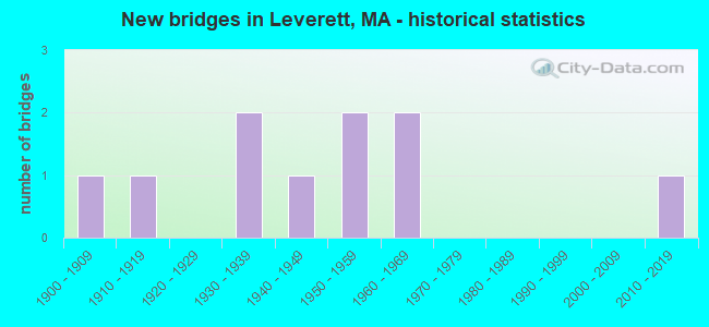
- New bridges - historical statistics
- 11900-1909
- 11910-1919
- 21930-1939
- 11940-1949
- 21950-1959
- 21960-1969
- 12010-2019

- Reconstructed bridges - Historical Statistics
- 11940-1949
- 01950-1959
- 01960-1969
- 11970-1979
- 11980-1989
- 01990-1999
- 02000-2009
- 22010-2019


- Bridge Condition - Deck
- 12.5%Excellent
- 12.5%Very good
- 25.0%Good
- 25.0%Satisfactory
- 25.0%Fair

- Bridge Condition - Superstructure
- 11.1%Excellent
- 33.3%Good
- 22.2%Satisfactory
- 33.3%Fair

- Bridge Condition - Substructure
- 11.1%Good
- 44.4%Satisfactory
- 44.4%Fair

- Bridge Condition - Channel
- 66.7%Good
- 33.3%Satisfactory
Find on map >> Show street view
Structure Number: L090010QVMUNNBI, Location: 0.2 MI W OF CSHMN RD (Lat: 42.435744, Lng: -72.492147), Route carried "on" structure: City street , Year Built: 1940, Status: Posted for load, Structure Length: 1.65m (5.41ft), Average Daily Traffic: 129 (year 2017), Average Future Daily Traffic: 816 (year 2032), Design Load: H 15, Features Intersected: WATER DOOLITTLE BROOK, Facility Carried by Structure: HWY TEAWADDLE HL
Minimum Vertical Clearance: 30+ m (98+ ft), Kilometerpoint: 1.609, Lanes on structure: 1, Owner: Town or Township Highway Agency, Approaching Roadway Width: 4.3m (14.1ft), Skew: 1 degrees, Material/Design: Steel, Design/Construction: Stringer/Multi-beam, Number Of Spans In Main Unit: 1, Length of Maximum Span: 15.2m (49.9ft), Curb or Sidewalk Widths: Left: 0.2m (0.7ft), Right: 0.2m (0.7ft), Curb-To-Curb Width: 4.3m (14.1ft), Out-to-Out Width: 5.2m (17.1ft)
Condition: Deck: Satisfactory, Superstructure: Satisfactory, Substructure: Satisfactory, Channel: Good, Operating Rating: 31.9 metric tons, Method Used To Determine Operating Rating: Load Factor (LF), Inventory Rating: 19.1 metric tons, Method Used To Determine Inventory Rating: Load Factor (LF), Structural Evaluation: Somewhat better than minimum adequacy, Deck Geometry: High priority of replacement, Waterway Adequacy: Better than present minimum criteria, Approach Roadway Alignment: Equal to present minimum criteria, Bridge Posting: Required (Relationship of Operating Rating to Maximum Legal Load: 0.1 - 9.9% below), Length Of Structure Improvement: 2.40m (7.87ft), Designated Inspection Frequency: Every 24 months, Inspection Date: November 2021, Bridge Improvement Cost: $1,496,000, Roadway Improvement Cost: $150,000, Total Project Cost: $2,245,000 ( Estimate for 2022), Deck Structure Type: Concrete Cast-file-Place, Wearing Surface/Protective System: Wearing Surface: Bituminous
Find on map >> Show street view
Structure Number: L090020M3MUNNBI, Location: .1 MI S OF SHUTESBURY RD. (Lat: 42.438533, Lng: -72.482619), Route carried "on" structure: City street , Year Built: 1963, Status: Open, Structure Length: 1.05m (3.44ft), Average Daily Traffic: 1,900 (year 2005), Truck Traffic: 4%, Average Future Daily Traffic: 4,493 (year 2032), Design Load: H 20, Features Intersected: WATER ROARING BROOK, Facility Carried by Structure: HWY CUSHMAN RD
Minimum Vertical Clearance: 30+ m (98+ ft), Kilometerpoint: 0.901, Lanes on structure: 2, Owner: Town or Township Highway Agency, Approaching Roadway Width: 7.9m (25.9ft), Skew: 2 degrees, Material/Design: Prestressed concrete, Design/Construction: Slab, Number Of Spans In Main Unit: 1, Length of Maximum Span: 10.2m (33.5ft), Curb or Sidewalk Widths: Left: 0.3m (1.0ft), Right: 0.3m (1.0ft), Curb-To-Curb Width: 7.9m (25.9ft), Out-to-Out Width: 8.5m (27.9ft)
Condition: Deck: Good, Superstructure: Good, Substructure: Satisfactory, Channel: Good, Operating Rating: 64.2 metric tons, Method Used To Determine Operating Rating: Load Factor (LF), Inventory Rating: 48.9 metric tons, Method Used To Determine Inventory Rating: Load Factor (LF), Structural Evaluation: Equal to present minimum criteria, Deck Geometry: Meets minimum limits, Waterway Adequacy: Better than present minimum criteria, Approach Roadway Alignment: Meets minimum limits, Length Of Structure Improvement: 1.10m (3.61ft), Designated Inspection Frequency: Every 24 months, Inspection Date: June 2021, Bridge Improvement Cost: $571,000, Roadway Improvement Cost: $58,000, Total Project Cost: $857,000 ( Estimate for 2022), Deck Structure Type: Concrete Precast Panels, Wearing Surface/Protective System: Wearing Surface: Bituminous, Membrane: Built-up
Find on map >> Show street view
Structure Number: L090030QRMUNNBI, Location: 100' S OF SHUTESBURY RD (Lat: 42.439806, Lng: -72.479722), Route carried "on" structure: City street , Year Built: 1960, Year Reconstructed: 1979, Status: Posted for load, Structure Length: 1.43m (4.69ft), Average Daily Traffic: 10 (year 2016), Truck Traffic: 1%, Average Future Daily Traffic: 16 (year 2033), Features Intersected: WATER ROARING BROOK, Facility Carried by Structure: HWY MILLERS RD
Minimum Vertical Clearance: 30+ m (98+ ft), Kilometerpoint: 0.145, Lanes on structure: 1, Owner: Town or Township Highway Agency, Approaching Roadway Width: 4.3m (14.1ft), Material/Design: Steel, Design/Construction: Stringer/Multi-beam, Number Of Spans In Main Unit: 1, Length of Maximum Span: 13.4m (44.0ft), Curb-To-Curb Width: 4.1m (13.5ft), Out-to-Out Width: 4.1m (13.5ft)
Condition: Deck: Fair, Superstructure: Fair, Substructure: Satisfactory, Channel: Good, Operating Rating: 47.1 metric tons, Method Used To Determine Operating Rating: Load Factor (LF), Inventory Rating: 28.2 metric tons, Method Used To Determine Inventory Rating: Load Factor (LF), Structural Evaluation: Somewhat better than minimum adequacy, Deck Geometry: Somewhat better than minimum adequacy, Waterway Adequacy: Better than present minimum criteria, Approach Roadway Alignment: Equal to present minimum criteria, Length Of Structure Improvement: 2.20m (7.22ft), Designated Inspection Frequency: Every 24 months, Inspection Date: January 2022, Bridge Improvement Cost: $565,000, Roadway Improvement Cost: $57,000, Total Project Cost: $848,000 ( Estimate for 2022), Deck Structure Type: Wood or Timber, Wearing Surface/Protective System: Wearing Surface: Wood or Timber
Find on map >> Show street view
Structure Number: L090040M2MUNNBI, Location: AT JCT BROAD HILL RD (Lat: 42.448889, Lng: -72.466581), Route carried "on" structure: City street , Year Built: 1959, Status: Open, Structure Length: 0.62m (2.03ft), Average Daily Traffic: 2,069 (year 2019), Truck Traffic: 6%, Average Future Daily Traffic: 3,159 (year 2032), Features Intersected: WATER ROARING BROOK, Facility Carried by Structure: HWY SHUTESBRY RD
Minimum Vertical Clearance: 30+ m (98+ ft), Kilometerpoint: 3.766, Lanes on structure: 2, Owner: Town or Township Highway Agency, Approaching Roadway Width: 7.6m (24.9ft), Skew: 1 degrees, Material/Design: Steel, Design/Construction: Culvert, Number Of Spans In Main Unit: 1, Length of Maximum Span: 6.2m (20.3ft)
Condition: Channel: Satisfactory, Culverts: Satisfactory, Operating Rating: 44.3 metric tons, Method Used To Determine Operating Rating: Allowable Stress (AS), Inventory Rating: 32.4 metric tons, Method Used To Determine Inventory Rating: Allowable Stress (AS), Structural Evaluation: Equal to present minimum criteria, Waterway Adequacy: Better than present minimum criteria, Approach Roadway Alignment: Better than present minimum criteria, Length Of Structure Improvement: 0.60m (1.97ft), Designated Inspection Frequency: Every 24 months, Inspection Date: March 2021, Bridge Improvement Cost: $341,000, Roadway Improvement Cost: $35,000, Total Project Cost: $512,000 ( Estimate for 2022), Wearing Surface/Protective System: Wearing Surface: Bituminous
Find on map >> Show street view
Structure Number: L090050M4MUNNBI, Location: JUST W OF SHUTESBURY LINE (Lat: 42.449672, Lng: -72.451550), Route carried "on" structure: City street , Year Built: 1959, Status: Open, Structure Length: 0.68m (2.23ft), Average Daily Traffic: 2,069 (year 2019), Truck Traffic: 6%, Average Future Daily Traffic: 3,159 (year 2032), Features Intersected: WATER ROARING BROOK, Facility Carried by Structure: HWY SHUTESBRY RD
Minimum Vertical Clearance: 30+ m (98+ ft), Kilometerpoint: 4.200, Lanes on structure: 2, Owner: Town or Township Highway Agency, Approaching Roadway Width: 7.4m (24.3ft), Skew: 4 degrees, Material/Design: Steel, Design/Construction: Arch - Deck, Number Of Spans In Main Unit: 1, Length of Maximum Span: 6.8m (22.3ft), Curb-To-Curb Width: 7.4m (24.3ft), Out-to-Out Width: 10.9m (35.8ft)
Condition: Superstructure: Satisfactory, Substructure: Fair, Channel: Good, Structural Evaluation: Somewhat better than minimum adequacy, Deck Geometry: High priority of replacement, Waterway Adequacy: Better than present minimum criteria, Approach Roadway Alignment: Equal to present minimum criteria, Length Of Structure Improvement: 0.70m (2.30ft), Designated Inspection Frequency: Every 24 months, Inspection Date: March 2021, Bridge Improvement Cost: $300,000, Roadway Improvement Cost: $31,000, Total Project Cost: $451,000 ( Estimate for 2022)
Find on map >> Show street view
Structure Number: L090060QQMUNNBI, Location: MOORES CORNER (Lat: 42.494222, Lng: -72.467722), Route carried "on" structure: City street , Year Built: 1938, Year Reconstructed: 2018, Status: Posted for load, Structure Length: 0.91m (2.99ft), Average Daily Traffic: 75 (year 2019), Average Future Daily Traffic: 409 (year 2032), Features Intersected: WATER SAWMILL RIVER, Facility Carried by Structure: HWY DUDLEYVILLE
Minimum Vertical Clearance: 30+ m (98+ ft), Kilometerpoint: 0.064, Lanes on structure: 1, Owner: Town or Township Highway Agency, Approaching Roadway Width: 5.2m (17.1ft), Skew: 2 degrees, Material/Design: Steel, Design/Construction: Stringer/Multi-beam, Number Of Spans In Main Unit: 1, Length of Maximum Span: 7.9m (25.9ft), Curb or Sidewalk Widths: Left: 0.2m (0.7ft), Right: 0.2m (0.7ft), Curb-To-Curb Width: 5.1m (16.7ft), Out-to-Out Width: 5.5m (18.0ft)
Condition: Deck: Very good, Superstructure: Fair, Substructure: Satisfactory, Channel: Good, Operating Rating: 55.0 metric tons, Method Used To Determine Operating Rating: Load Factor (LF), Inventory Rating: 33.0 metric tons, Method Used To Determine Inventory Rating: Load Factor (LF), Structural Evaluation: Somewhat better than minimum adequacy, Deck Geometry: High priority of corrective action, Waterway Adequacy: Equal to present minimum criteria, Approach Roadway Alignment: High priority of corrective action, Designated Inspection Frequency: Every 24 months, Inspection Date: September 2021, Deck Structure Type: Corrugated Steel, Wearing Surface/Protective System: Wearing Surface: Bituminous
Find on map >> Show street view
Structure Number: L090070QUMUNNBI, Location: JCT OLD MILL YD RD (Lat: 42.491678, Lng: -72.476269), Route carried "on" structure: City street , Year Built: 1938, Year Reconstructed: 1980, Status: Open, Structure Length: 0.99m (3.25ft), Average Daily Traffic: 129 (year 2001), Truck Traffic: 4%, Average Future Daily Traffic: 204 (year 2032), Features Intersected: WATER SAWMILL RIVER, Facility Carried by Structure: HWY RATTLESNAKE
Minimum Vertical Clearance: 30+ m (98+ ft), Kilometerpoint: 2.623, Lanes on structure: 2, Owner: Town or Township Highway Agency, Approaching Roadway Width: 5.2m (17.1ft), Skew: 1 degrees, Material/Design: Steel, Design/Construction: Stringer/Multi-beam, Number Of Spans In Main Unit: 1, Length of Maximum Span: 9.2m (30.2ft), Curb or Sidewalk Widths: Left: 0.2m (0.7ft), Right: 0.2m (0.7ft), Curb-To-Curb Width: 6.7m (22.0ft), Out-to-Out Width: 7.0m (23.0ft)
Condition: Deck: Fair, Superstructure: Fair, Substructure: Fair, Channel: Satisfactory, Operating Rating: 54.9 metric tons, Method Used To Determine Operating Rating: Load Factor (LF), Inventory Rating: 32.9 metric tons, Method Used To Determine Inventory Rating: Load Factor (LF), Structural Evaluation: Somewhat better than minimum adequacy, Deck Geometry: Meets minimum limits, Waterway Adequacy: Equal to present minimum criteria, Approach Roadway Alignment: Somewhat better than minimum adequacy, Length Of Structure Improvement: 1.00m (3.28ft), Designated Inspection Frequency: Every 24 months, Inspection Date: November 2020, Bridge Improvement Cost: $275,000, Roadway Improvement Cost: $28,000, Total Project Cost: $413,000 ( Estimate for 2022), Deck Structure Type: Corrugated Steel, Wearing Surface/Protective System: Wearing Surface: Bituminous
Find on map >> Show street view
Structure Number: L090090QTMUNNBI, Location: NE OF HEMENWAY RD (Lat: 42.496981, Lng: -72.478339), Route carried "on" structure: City street , Year Built: 1910, Year Reconstructed: 2019, Status: Open, Structure Length: 0.80m (2.62ft), Average Daily Traffic: 650 (year 2016), Average Future Daily Traffic: 204 (year 2033), Design Load: HS 20, Features Intersected: WATER SAWMILL RIVER, Facility Carried by Structure: HWY OLD COKE KLN
Minimum Vertical Clearance: 30+ m (98+ ft), Kilometerpoint: 0.064, Lanes on structure: 1, Owner: Town or Township Highway Agency, Approaching Roadway Width: 4.0m (13.1ft), Material/Design: Wood or Timber, Design/Construction: Slab, Number Of Spans In Main Unit: 1, Length of Maximum Span: 7.4m (24.3ft), Curb or Sidewalk Widths: Left: 0.1m (0.3ft), Right: 0.1m (0.3ft), Curb-To-Curb Width: 4.0m (13.1ft), Out-to-Out Width: 5.0m (16.4ft)
Condition: Deck: Excellent, Superstructure: Excellent, Substructure: Fair, Channel: Good, Operating Rating: 58.3 metric tons, Method Used To Determine Operating Rating: Load and Resistance Factor Rating (LRFR) rating reported by rating factor(RF) method using HL-93 loadings, Inventory Rating: 45.4 metric tons, Method Used To Determine Inventory Rating: Load and Resistance Factor Rating (LRFR) rating reported by rating factor(RF) method using HL-93 loadings, Structural Evaluation: Somewhat better than minimum adequacy, Deck Geometry: High priority of replacement, Waterway Adequacy: Somewhat better than minimum adequacy, Approach Roadway Alignment: Better than present minimum criteria, Designated Inspection Frequency: Every 24 months, Underwater Inspection Frequency: Every 46 months, Inspection Date: January 2022, Underwater Inspection Date: August 2018, Deck Structure Type: Wood or Timber, Wearing Surface/Protective System: Wearing Surface: Wood or Timber
Find on map >> Show street view
Structure Number: L090100M5MUNNBI, Location: JUST S OF N LEVERETT RD (Lat: 42.507422, Lng: -72.492153), Route carried "on" structure: City street , Year Built: 1900, Year Reconstructed: 1954, Status: Open, Structure Length: 2.19m (7.19ft), Average Daily Traffic: 1,551 (year 2017), Truck Traffic: 3%, Average Future Daily Traffic: 2,448 (year 2032), Design Load: H 15, Features Intersected: WATER SAWMILL RIVER, Facility Carried by Structure: HWY CAVE HILL RD
Minimum Vertical Clearance: 30+ m (98+ ft), Kilometerpoint: 3.621, Lanes on structure: 2, Owner: Town or Township Highway Agency, Approaching Roadway Width: 6.1m (20.0ft), Material/Design: Steel continuous, Design/Construction: Stringer/Multi-beam, Number Of Spans In Main Unit: 2, Length of Maximum Span: 10.7m (35.1ft), Curb or Sidewalk Widths: Left: 0.3m (1.0ft), Right: 0.3m (1.0ft), Curb-To-Curb Width: 6.1m (20.0ft), Out-to-Out Width: 7.6m (24.9ft)
Condition: Deck: Satisfactory, Superstructure: Good, Substructure: Fair, Channel: Satisfactory, Operating Rating: 54.4 metric tons, Method Used To Determine Operating Rating: Load Factor (LF), Inventory Rating: 32.6 metric tons, Method Used To Determine Inventory Rating: Load Factor (LF), Structural Evaluation: Somewhat better than minimum adequacy, Deck Geometry: High priority of replacement, Waterway Adequacy: Better than present minimum criteria, Approach Roadway Alignment: Somewhat better than minimum adequacy, Length Of Structure Improvement: 2.20m (7.22ft), Designated Inspection Frequency: Every 24 months, Underwater Inspection Frequency: Every 35 months, Inspection Date: April 2021, Underwater Inspection Date: September 2019, Bridge Improvement Cost: $657,000, Roadway Improvement Cost: $66,000, Total Project Cost: $986,000 ( Estimate for 2022), Deck Structure Type: Concrete Cast-file-Place, Wearing Surface/Protective System: Wearing Surface: Bituminous
Find on map >> Show street view
Structure Number: L09011B2JDOT634, Location: 2.1 M N AMHERST T.L. (Lat: 42.457044, Lng: -72.522736), Route carried "on" structure: State highway 63, Year Built: 2010, Status: Open, Structure Length: 5.88m (19.29ft), Average Daily Traffic: 4,138 (year 2018), Truck Traffic: 9%, Average Future Daily Traffic: 6,001 (year 2031), Design Load: HS 25 or greater, Features Intersected: RR NECRR
Minimum Vertical Clearance: 30+ m (98+ ft), Kilometerpoint: 6.135, Lanes on structure: 2, Owner: State Highway Agency, Approaching Roadway Width: 14.5m (47.6ft), Skew: 5 degrees, Material/Design: Steel continuous, Design/Construction: Stringer/Multi-beam, Number Of Spans In Main Unit: 3, Length of Maximum Span: 21.5m (70.5ft), Curb or Sidewalk Widths: Left: 0.0m, Right: 1.8m (5.9ft), Curb-To-Curb Width: 12.5m (41.0ft), Out-to-Out Width: 15.1m (49.5ft)
Condition: Deck: Good, Superstructure: Good, Substructure: Good, Operating Rating: 94.9 metric tons, Method Used To Determine Operating Rating: Load Factor (LF), Inventory Rating: 56.7 metric tons, Method Used To Determine Inventory Rating: Load Factor (LF), Structural Evaluation: Better than present minimum criteria, Deck Geometry: Equal to present minimum criteria, Underclear: High priority of corrective action, Approach Roadway Alignment: Equal to present desirable criteria, Length Of Structure Improvement: 5.90m (19.36ft), Designated Inspection Frequency: Every 24 months, Inspection Date: September 2020, Bridge Improvement Cost: $501,000, Roadway Improvement Cost: $51,000, Total Project Cost: $752,000 ( Estimate for 2022), Deck Structure Type: Concrete Cast-file-Place, Wearing Surface/Protective System: Wearing Surface: Bituminous, Membrane: Preformed Fabric, Deck Protection: Epoxy Coated Reinforcing