Leverett, Massachusetts
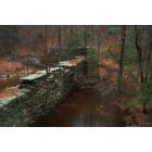
Submit your own pictures of this town and show them to the world
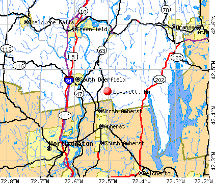
- OSM Map
- General Map
- Google Map
- MSN Map
Population change since 2000: +11.3%
 |
| Males: 922 | |
| Females: 929 |
| Median resident age: | 48.7 years |
| Massachusetts median age: | 39.2 years |
Zip codes: 01054.
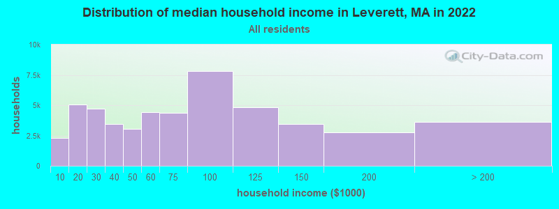
| Leverett: | $108,996 |
| MA: | $94,488 |
Estimated per capita income in 2022: $58,103 (it was $31,891 in 2000)
Leverett town income, earnings, and wages data
Estimated median house or condo value in 2022: $445,094 (it was $179,100 in 2000)
| Leverett: | $445,094 |
| MA: | $534,700 |
Mean prices in 2022: all housing units: $313,377; detached houses: $324,224; townhouses or other attached units: $284,225; in 2-unit structures: $287,978; in 3-to-4-unit structures: $183,938; in 5-or-more-unit structures: $249,762; mobile homes: $62,200
Detailed information about poverty and poor residents in Leverett, MA


- 1,69091.3%White alone
- 633.4%Two or more races
- 392.1%Hispanic
- 291.6%Asian alone
- 221.2%Black alone
- 50.3%Other race alone
- 30.2%American Indian alone
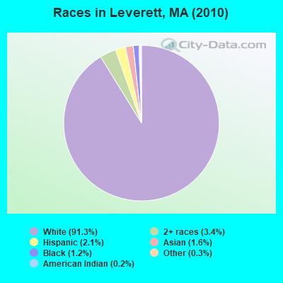
Races in Leverett detailed stats: ancestries, foreign born residents, place of birth
Type |
2009 |
2010 |
2011 |
2012 |
2013 |
2014 |
2015 |
2016 |
2017 |
2018 |
2019 |
2020 |
2021 |
2022 |
|---|---|---|---|---|---|---|---|---|---|---|---|---|---|---|
| Murders (per 100,000) | 0 (0.0) | 0 (0.0) | 0 (0.0) | 0 (0.0) | 0 (0.0) | 0 (0.0) | 0 (0.0) | 0 (0.0) | 0 (0.0) | 0 (0.0) | 0 (0.0) | 0 (0.0) | 0 (0.0) | 0 (0.0) |
| Rapes (per 100,000) | 0 (0.0) | 0 (0.0) | 1 (53.7) | 1 (53.4) | 0 (0.0) | 1 (53.7) | 0 (0.0) | 0 (0.0) | 0 (0.0) | 0 (0.0) | 0 (0.0) | 0 (0.0) | 2 (109.0) | 0 (0.0) |
| Robberies (per 100,000) | 0 (0.0) | 0 (0.0) | 0 (0.0) | 0 (0.0) | 0 (0.0) | 0 (0.0) | 0 (0.0) | 0 (0.0) | 0 (0.0) | 0 (0.0) | 0 (0.0) | 0 (0.0) | 0 (0.0) | 0 (0.0) |
| Assaults (per 100,000) | 0 (0.0) | 0 (0.0) | 1 (53.7) | 2 (106.7) | 2 (106.9) | 0 (0.0) | 0 (0.0) | 1 (54.3) | 0 (0.0) | 0 (0.0) | 1 (53.7) | 1 (54.5) | 0 (0.0) | 1 (53.7) |
| Burglaries (per 100,000) | 5 (282.2) | 2 (108.0) | 7 (375.9) | 9 (480.3) | 3 (160.3) | 4 (214.7) | 2 (107.8) | 2 (108.5) | 3 (163.5) | 2 (107.9) | 3 (161.0) | 0 (0.0) | 0 (0.0) | 1 (53.7) |
| Thefts (per 100,000) | 5 (282.2) | 5 (270.1) | 8 (429.6) | 14 (747.1) | 9 (481.0) | 9 (483.1) | 7 (377.2) | 17 (922.4) | 4 (218.0) | 11 (593.6) | 1 (53.7) | 4 (217.9) | 3 (163.5) | 6 (322.4) |
| Auto thefts (per 100,000) | 1 (56.4) | 0 (0.0) | 2 (107.4) | 0 (0.0) | 0 (0.0) | 0 (0.0) | 0 (0.0) | 0 (0.0) | 0 (0.0) | 0 (0.0) | 1 (53.7) | 0 (0.0) | 0 (0.0) | 1 (53.7) |
| Arson (per 100,000) | 0 (0.0) | 0 (0.0) | 0 (0.0) | 0 (0.0) | 0 (0.0) | 0 (0.0) | 0 (0.0) | 0 (0.0) | 0 (0.0) | 0 (0.0) | 0 (0.0) | 0 (0.0) | 0 (0.0) | 0 (0.0) |
| City-Data.com crime index | 35.6 | 18.4 | 105.8 | 127.5 | 51.8 | 77.3 | 22.6 | 55.3 | 20.2 | 31.3 | 28.4 | 19.6 | 93.7 | 31.7 |
The City-Data.com crime index weighs serious crimes and violent crimes more heavily. Higher means more crime, U.S. average is 246.1. It adjusts for the number of visitors and daily workers commuting into cities.
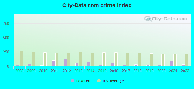
Crime rate in Leverett detailed stats: murders, rapes, robberies, assaults, burglaries, thefts, arson
Full-time law enforcement employees in 2021, including police officers: 3 (3 officers - 3 male; 0 female).
| Officers per 1,000 residents here: | 1.63 |
| Massachusetts average: | 2.53 |
 Recent articles from our blog. Our writers, many of them Ph.D. graduates or candidates, create easy-to-read articles on a wide variety of topics.

 | Estate In Leverett (6 replies) |
| Crisis on MA roads (345 replies) |
| 2023 Real Estate Observations (5278 replies) |
| Re-name Storrow Drive to Barack Obama Drive (47 replies) |
| Like he** I'm going to pay these prices! (684 replies) |
| What Is Yankee Culture? (61 replies) |
Latest news from Leverett, MA collected exclusively by city-data.com from local newspapers, TV, and radio stations
Ancestries: English (21.5%), Irish (14.4%), German (13.4%), Polish (7.8%), Italian (7.3%), French (6.6%).
Current Local Time: EST time zone
Incorporated in 1774
Elevation: 438 feet
Land area: 22.8 square miles.
Population density: 81 people per square mile (very low).
97 residents are foreign born (3.1% Europe, 0.8% Latin America, 0.8% Africa).
| This town: | 5.8% |
| Massachusetts: | 12.2% |
| Leverett town: | 1.7% ($3,010) |
| Massachusetts: | 1.3% ($2,336) |
Nearest city with pop. 50,000+: Chicopee, MA  (21.9 miles , pop. 54,653).
Nearest city with pop. 200,000+: Boston, MA (72.8 miles , pop. 589,141).
Nearest city with pop. 1,000,000+: Bronx, NY (133.4 miles , pop. 1,332,650).
Nearest cities:
), ), )Latitude: 42.48 N, Longitude: 72.50 W
Area code commonly used in this area: 413

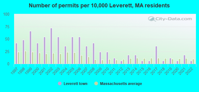
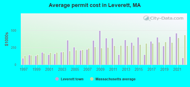
Single-family new house construction building permits:
- 2022: 1 building, cost: $100,000
- 2021: 3 buildings, average cost: $460,300
- 2020: 1 building, cost: $411,000
- 2019: 2 buildings, average cost: $275,000
- 2018: 1 building, cost: $400,000
- 2017: 6 buildings, average cost: $344,200
- 2016: 1 building, cost: $150,000
- 2015: 1 building, cost: $400,000
- 2014: 3 buildings, average cost: $323,700
- 2013: 3 buildings, average cost: $361,700
- 2012: 1 building, cost: $150,000
- 2011: 2 buildings, average cost: $390,400
- 2010: 4 buildings, average cost: $389,500
- 2009: 4 buildings, average cost: $499,200
- 2008: 7 buildings, average cost: $353,700
- 2007: 6 buildings, average cost: $222,600
- 2006: 9 buildings, average cost: $213,000
- 2005: 9 buildings, average cost: $258,600
- 2004: 6 buildings, average cost: $358,700
- 2003: 9 buildings, average cost: $185,400
- 2002: 12 buildings, average cost: $161,400
- 2001: 9 buildings, average cost: $147,200
- 2000: 7 buildings, average cost: $180,800
- 1999: 11 buildings, average cost: $133,100
- 1998: 8 buildings, average cost: $141,600
- 1997: 7 buildings, average cost: $96,200
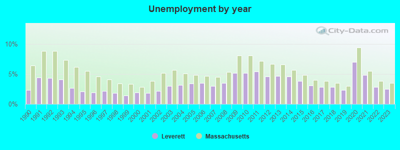
| Here: | 2.5% |
| Massachusetts: | 3.5% |
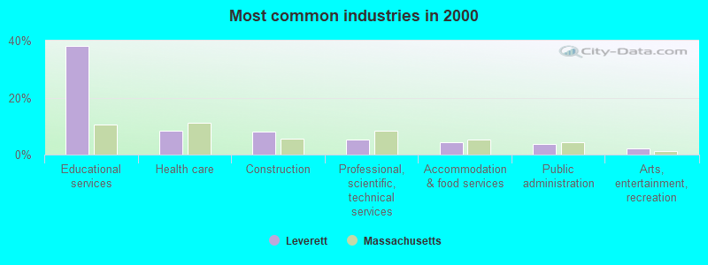
- Educational services (38.1%)
- Health care (8.5%)
- Construction (8.0%)
- Professional, scientific, technical services (5.4%)
- Accommodation & food services (4.2%)
- Public administration (3.6%)
- Arts, entertainment, recreation (2.2%)
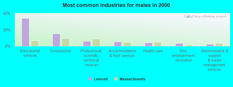
- Educational services (33.9%)
- Construction (15.2%)
- Professional, scientific, technical services (6.1%)
- Accommodation & food services (5.3%)
- Health care (4.2%)
- Arts, entertainment, recreation (3.4%)
- Administrative & support & waste management services (2.6%)
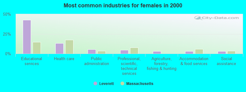
- Educational services (42.6%)
- Health care (13.2%)
- Public administration (5.4%)
- Professional, scientific, technical services (4.7%)
- Agriculture, forestry, fishing & hunting (3.1%)
- Accommodation & food services (3.1%)
- Social assistance (3.1%)
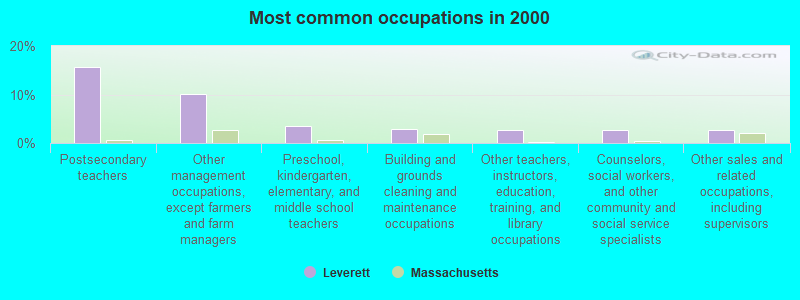
- Postsecondary teachers (15.6%)
- Other management occupations, except farmers and farm managers (10.2%)
- Preschool, kindergarten, elementary, and middle school teachers (3.5%)
- Building and grounds cleaning and maintenance occupations (2.9%)
- Other teachers, instructors, education, training, and library occupations (2.8%)
- Counselors, social workers, and other community and social service specialists (2.8%)
- Other sales and related occupations, including supervisors (2.7%)
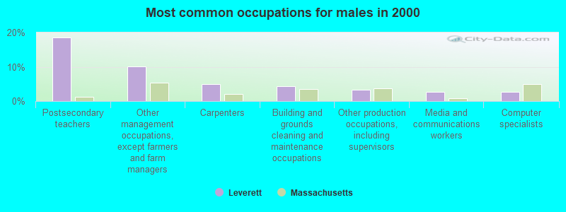
- Postsecondary teachers (18.6%)
- Other management occupations, except farmers and farm managers (10.1%)
- Carpenters (5.1%)
- Building and grounds cleaning and maintenance occupations (4.2%)
- Other production occupations, including supervisors (3.2%)
- Media and communications workers (2.6%)
- Computer specialists (2.6%)
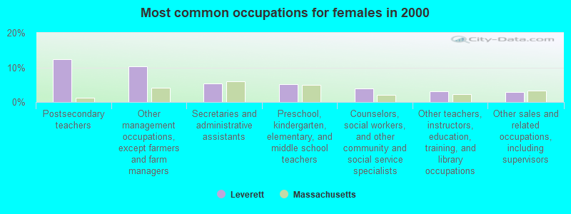
- Postsecondary teachers (12.3%)
- Other management occupations, except farmers and farm managers (10.3%)
- Secretaries and administrative assistants (5.4%)
- Preschool, kindergarten, elementary, and middle school teachers (5.1%)
- Counselors, social workers, and other community and social service specialists (4.0%)
- Other teachers, instructors, education, training, and library occupations (3.1%)
- Other sales and related occupations, including supervisors (2.9%)
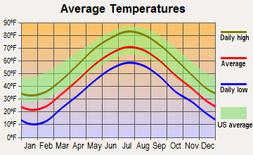
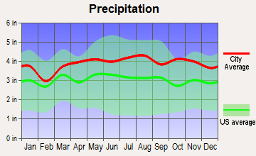
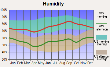
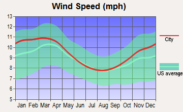
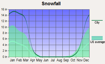
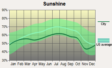
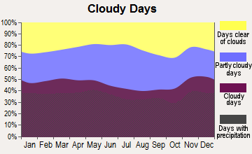
Average climate in Leverett, Massachusetts
Based on data reported by over 4,000 weather stations
(lower is better)
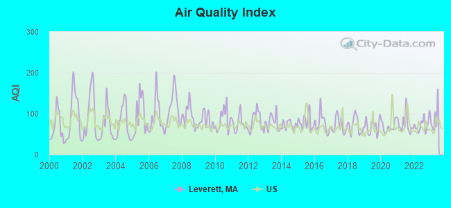
Air Quality Index (AQI) level in 2022 was 73.1. This is about average.
| City: | 73.1 |
| U.S.: | 72.6 |
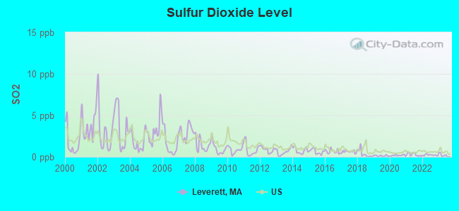
Sulfur Dioxide (SO2) [ppb] level in 2022 was 0.216. This is significantly better than average. Closest monitor was 8.1 miles away from the city center.
| City: | 0.216 |
| U.S.: | 1.515 |
Ozone [ppb] level in 2022 was 26.9. This is better than average. Closest monitor was 5.6 miles away from the city center.
| City: | 26.9 |
| U.S.: | 33.3 |
Particulate Matter (PM2.5) [µg/m3] level in 2022 was 6.97. This is about average. Closest monitor was 10.0 miles away from the city center.
| City: | 6.97 |
| U.S.: | 8.11 |
Tornado activity:
Leverett-area historical tornado activity is above Massachusetts state average. It is 10% smaller than the overall U.S. average.
On 6/9/1953, a category F4 (max. wind speeds 207-260 mph) tornado 16.8 miles away from the Leverett town center killed 90 people and injured 1228 people and caused between $50,000,000 and $500,000,000 in damages.
On 10/3/1979, a category F4 tornado 31.5 miles away from the town center killed 3 people and injured 500 people and caused between $50,000,000 and $500,000,000 in damages.
Earthquake activity:
Leverett-area historical earthquake activity is significantly above Massachusetts state average. It is 70% smaller than the overall U.S. average.On 10/7/1983 at 10:18:46, a magnitude 5.3 (5.1 MB, 5.3 LG, 5.1 ML, Class: Moderate, Intensity: VI - VII) earthquake occurred 137.9 miles away from the city center
On 4/20/2002 at 10:50:47, a magnitude 5.3 (5.3 ML, Depth: 3.0 mi) earthquake occurred 152.9 miles away from Leverett center
On 4/20/2002 at 10:50:47, a magnitude 5.2 (5.2 MB, 4.2 MS, 5.2 MW, 5.0 MW) earthquake occurred 151.7 miles away from the city center
On 1/19/1982 at 00:14:42, a magnitude 4.7 (4.5 MB, 4.7 MD, 4.5 LG, Class: Light, Intensity: IV - V) earthquake occurred 83.9 miles away from the city center
On 10/16/2012 at 23:12:25, a magnitude 4.7 (4.7 ML, Depth: 10.0 mi) earthquake occurred 121.0 miles away from the city center
On 10/2/1994 at 11:27:22, a magnitude 3.7 (3.5 LG, 3.7 LG, Depth: 6.2 mi, Class: Light, Intensity: II - III) earthquake occurred 14.6 miles away from Leverett center
Magnitude types: regional Lg-wave magnitude (LG), body-wave magnitude (MB), duration magnitude (MD), local magnitude (ML), surface-wave magnitude (MS), moment magnitude (MW)
Natural disasters:
The number of natural disasters in Franklin County (20) is greater than the US average (15).Major Disasters (Presidential) Declared: 9
Emergencies Declared: 10
Causes of natural disasters: Floods: 5, Storms: 5, Hurricanes: 4, Snowstorms: 4, Winter Storms: 3, Blizzards: 2, Snows: 2, Snowfall: 1, Tropical Storm: 1, Wind: 1, Other: 1 (Note: some incidents may be assigned to more than one category).

Hospitals and medical centers near Leverett:
- COZY CORNER NURSING AND REHABILITATION CENTER (Nursing Home, about 5 miles away; SUNDERLAND, MA)
- HOSPICE OF THE FISHER HOME (Hospital, about 6 miles away; AMHERST, MA)
- CENTER FOR EXTENDED CARE AT AMHERST (Nursing Home, about 8 miles away; AMHERST, MA)
- HADLEY AT ELAINE CARE AND REHABILITATION CENTER (Nursing Home, about 9 miles away; HADLEY, MA)
- GENTIVA HEALTH SERVICES (Home Health Center, about 10 miles away; GREENFIELD, MA)
- HOME CARE PRN INC (Home Health Center, about 10 miles away; GREENFIELD, MA)
- BUCKLEY-GREENFIELD HEALTHCARE CENTER (Nursing Home, about 10 miles away; GREENFIELD, MA)
Operable nuclear power plant near Leverett:
- 20 miles: Vermont Yankee in Vernon, VT.
Colleges/universities with over 2000 students nearest to Leverett:
- University of Massachusetts-Amherst (about 7 miles; Amherst, MA; Full-time enrollment: 26,583)
- Smith College (about 14 miles; Northampton, MA; FT enrollment: 3,549)
- Mount Holyoke College (about 16 miles; South Hadley, MA; FT enrollment: 2,573)
- Holyoke Community College (about 22 miles; Holyoke, MA; FT enrollment: 4,911)
- Western New England University (about 26 miles; Springfield, MA; FT enrollment: 3,477)
- American International College (about 26 miles; Springfield, MA; FT enrollment: 2,733)
- Springfield Technical Community College (about 27 miles; Springfield, MA; FT enrollment: 4,750)
Public elementary/middle school in Leverett:
- LEVERETT ELEMENTARY (Students: 171, Location: 85 MONTAGUE RD, Grades: PK-6)
User-submitted facts and corrections:
- there is a new library in Leverett on Montague Rd now.
Points of interest:
Notable locations in Leverett: Leverett Fire Department (A), Bradford M Field Memorial Library (B). Display/hide their locations on the map
Churches in Leverett include: Friends Meeting Church (A), Moores Corner Church (B). Display/hide their locations on the map
Cemeteries: Jackson Hill Cemetery (1), Mervel Cemetery (2), Long Plain Cemetery (3), Plainview Cemetery (4), Mount Hope Cemetery (5), Gardner Cemetery (6). Display/hide their locations on the map
Reservoir: Leverett Pond (A). Display/hide its location on the map
Streams, rivers, and creeks: Chestnut Hill Brook (A), Williams Brook (B), Red Brook (C), Gardner Brook (D), Mountain Brook (E). Display/hide their locations on the map
Birthplace of: Ellen Gilbert - Chess player.
| This town: | 2.4 people |
| Massachusetts: | 2.5 people |
| This town: | 66.0% |
| Whole state: | 63.0% |
| This town: | 8.8% |
| Whole state: | 7.0% |
Likely homosexual households (counted as self-reported same-sex unmarried-partner households)
- Lesbian couples: 2.5% of all households
- Gay men: 0.0% of all households
| This town: | 5.4% |
| Whole state: | 9.3% |
| This town: | 2.8% |
| Whole state: | 4.4% |
35 people in religious group quarters in 2000
For population 15 years and over in Leverett:
- Never married: 30.0%
- Now married: 55.4%
- Separated: 1.0%
- Widowed: 2.9%
- Divorced: 10.6%
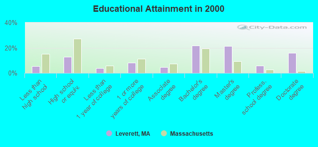
For population 25 years and over in Leverett:
- High school or higher: 94.4%
- Bachelor's degree or higher: 65.0%
- Graduate or professional degree: 43.3%
- Unemployed: 4.3%
- Mean travel time to work (commute): 25.2 minutes
| Here: | 12.2 |
| Massachusetts average: | 13.1 |


Graphs represent county-level data. Detailed 2008 Election Results
Religion statistics for Leverett, MA (based on Franklin County data)


| Religion | Adherents | Congregations |
|---|---|---|
| Catholic | 16,509 | 15 |
| Mainline Protestant | 4,617 | 38 |
| Evangelical Protestant | 2,079 | 20 |
| Other | 1,580 | 21 |
| None | 46,587 | - |
Food Environment Statistics:
| Here: | 3.63 / 10,000 pop. |
| Massachusetts: | 1.98 / 10,000 pop. |
| This county: | 0.14 / 10,000 pop. |
| State: | 0.05 / 10,000 pop. |
| Here: | 1.67 / 10,000 pop. |
| Massachusetts: | 2.22 / 10,000 pop. |
| Franklin County: | 3.21 / 10,000 pop. |
| Massachusetts: | 1.77 / 10,000 pop. |
| Franklin County: | 8.10 / 10,000 pop. |
| Massachusetts: | 8.76 / 10,000 pop. |
| Here: | 7.5% |
| Massachusetts: | 8.1% |
| Franklin County: | 22.2% |
| Massachusetts: | 22.5% |
| Franklin County: | 15.1% |
| Massachusetts: | 16.5% |
Strongest AM radio stations in Leverett:
- WNNZ (640 AM; 50 kW; WESTFIELD, MA; Owner: CLEAR CHANNEL BROADCASTING LICENSES, INC.)
- WIZZ (1520 AM; daytime; 10 kW; GREENFIELD, MA; Owner: P. & M. RADIO, LLC)
- WCRN (830 AM; 50 kW; WORCESTER, MA; Owner: CARTER BROADCASTING CORPORATION)
- WPNI (1430 AM; 5 kW; AMHERST, MA; Owner: WESTERN MASSACHUSETTS RADIO COMPANY)
- WVNE (760 AM; daytime; 25 kW; LEICESTER, MA; Owner: BLOUNT MASSCOM, INC.)
- WCAT (700 AM; daytime; 2 kW; ORANGE-ATHOL, MA; Owner: CITADEL BROADCASTING COMPANY)
- WTIC (1080 AM; 50 kW; HARTFORD, CT; Owner: INFINITY RADIO OPERATIONS INC.)
- WHYN (560 AM; 5 kW; SPRINGFIELD, MA; Owner: CLEAR CHANNEL BROADCASTING LICENSES, INC.)
- WRKO (680 AM; 50 kW; BOSTON, MA; Owner: ENTERCOM BOSTON LICENSE, LLC)
- WALE (990 AM; 50 kW; GREENVILLE, RI; Owner: NORTH AMERICAN BROADCASTING CO., INC.)
- WEEI (850 AM; 50 kW; BOSTON, MA; Owner: ENTERCOM BOSTON LICENSE, LLC)
- WKOX (1200 AM; 50 kW; FRAMINGHAM, MA; Owner: CAPSTAR TX LIMITED PARTNERSHIP)
- WACE (730 AM; 5 kW; CHICOPEE, MA; Owner: CARTER BROADCASTING CORP.)
Strongest FM radio stations in Leverett:
- WFCR (88.5 FM; AMHERST, MA; Owner: UNIVERSITY OF MASSACHUSETTS)
- WAMH (89.3 FM; AMHERST, MA; Owner: TRUSTEES OF AMHERST COLLEGE)
- W246AM (97.1 FM; AMHERST, MA; Owner: GREAT NORTHERN RADIO, LLC)
- WGAJ (91.7 FM; DEERFIELD, MA; Owner: TRUATEES OF DEERFIELD ACADEMY)
- WHAI (98.3 FM; GREENFIELD, MA; Owner: SAGA COMMUNICATIONS OF NEW ENGLAND, LLC)
- WHYN-FM (93.1 FM; SPRINGFIELD, MA; Owner: CLEAR CHANNEL BROADCASTING LICENSES, INC.)
- WPVQ (95.3 FM; GREENFIELD, MA; Owner: GREAT NORTHERN RADIO, L.L.C.)
- WRNX (100.9 FM; AMHERST, MA; Owner: WESTERN MASSACHUSETTS RADIO COMPANY)
- WRSI (93.9 FM; TURNERS FALLS, MA; Owner: GREAT NORTHERN RADIO, LLC)
- WAMC-FM (90.3 FM; ALBANY, NY; Owner: WAMC)
- WLZX (99.3 FM; NORTHAMPTON, MA; Owner: SAGA COMMUNICATIONS OF NEW ENGLAND, LLC)
- WJDF (97.3 FM; ORANGE, MA; Owner: DEANE BROTHERS BROADCASTING CORP.)
- WYRY (104.9 FM; HINSDALE, NH; Owner: TRI-VALLEY BROADCASTING CORPORATION)
- WMUA (91.1 FM; AMHERST, MA; Owner: UNIVERSITY OF MASSACHUSETTS)
- WEQX (102.7 FM; MANCHESTER, VT; Owner: NORTHSHIRE COMMUNICATIONS, INC.)
- WEIB (106.3 FM; NORTHAMPTON, MA; Owner: CUTTING EDGE BROADCASTING, INC.)
- WVAY (100.7 FM; WILMINGTON, VT; Owner: GREAT NORTHERN RADIO, L.L.C.)
- WJAN (95.1 FM; SUNDERLAND, VT; Owner: 6 JOHNSON ROAD LICENSES, INC.)
- WAAF (107.3 FM; WORCESTER, MA; Owner: ENTERCOM BOSTON LICENSE, LLC)
- WFEX (92.1 FM; PETERBOROUGH, NH; Owner: FNX BROADCASTING OF NEW HAMPSHIRE LLC)
TV broadcast stations around Leverett:
- WYDN (Channel 48; WORCESTER, MA; Owner: EDUCATIONAL PUBLIC TV CORPORATION)
- WUNI (Channel 27; WORCESTER, MA; Owner: ENTRAVISION HOLDINGS, LLC)
- WTIC-TV (Channel 61; HARTFORD, CT; Owner: TRIBUNE TELEVISION COMPANY)
- WWLP (Channel 22; SPRINGFIELD, MA; Owner: WWLP BROADCASTING, LLC)
- W67DF (Channel 67; SPRINGFIELD, MA; Owner: TRINITY BROADCASTING NETWORK)
- W35BK (Channel 35; PLAINFIELD, MA; Owner: LYDIA SYLVANE STOCKWELL)
- WGGB-TV (Channel 40; SPRINGFIELD, MA; Owner: WGGB LICENSEE, LLC)
- WGBY-TV (Channel 57; SPRINGFIELD, MA; Owner: WGBH EDUCATIONAL FOUNDATION)
- Leverett, Massachusetts
- Fatal accident count10
- Vehicles involved in fatal accidents16
- Fatal accidents involving drunk persons:2
- Fatalities10
- Persons involved in fatal accidents24
- Pedestrians involved in fatal accidents0
- Massachusetts average
- Fatal accident count4005
- Vehicles involved in fatal accidents5813
- Fatal accidents involving drunk persons1145
- Fatalities4257
- Persons involved in fatal accidents8839
- Pedestrians involved in fatal accidents802
- National Bridge Inventory (NBI) Statistics
- 10Number of bridges
- 52ft / 16.2mTotal length
- $7,064,000Total costs
- 12,720Total average daily traffic
- 747Total average daily truck traffic
- 20,909Total future (year 2031) average daily traffic
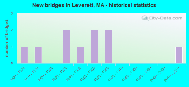
- New bridges - historical statistics
- 11900-1909
- 11910-1919
- 21930-1939
- 11940-1949
- 21950-1959
- 21960-1969
- 12010-2019
FCC Registered Antenna Towers:
3- Michael J Umano, 309 Long Plain Road (Lat: 42.468472 Lon: -72.512889), Type: 33.5, Structure height: 25011 m, Overall height: 33.5 m, Registrant: Industrial Tower And Wireless, LLC, Kevin.Delaney@induscom.Com, , Marsh-field, Phone: (781) 319-1011
- Michael J Umano, 309 Long Plain Road (Lat: 42.468472 Lon: -72.512889), Type: 33.5, Structure height: 25011 m, Overall height: 33.5 m, Registrant: Industrial Tower And Wireless, LLC, Kevin.Delaney@induscom.Com, , Marsh-field, Phone: (781) 319-1011
- Michael J Umano, 309 Long Plain Road (Lat: 42.468472 Lon: -72.512889), Type: 33.5, Structure height: 25011 m, Overall height: 33.5 m, Registrant: Industrial Tower And Wireless, LLC, Kevin.Delaney@induscom.Com, , Marsh-field, Phone: (781) 319-1011
FCC Registered Amateur Radio Licenses:
18 (See the full list of FCC Registered Amateur Radio Licenses in Leverett)FAA Registered Aircraft:
5- Aircraft: CESSNA 170B (Category: Land, Seats: 4, Weight: Up to 12,499 Pounds, Speed: 105 mph), Engine: CONT MOTOR C145 SERIES (145 HP) (Reciprocating)
N-Number: 2242D, N2242D, N-2242D, Serial Number: 20394, Year manufactured: 1952, Airworthiness Date: 06/01/1956, Certificate Issue Date: 08/11/2020
Registrant (Co-Owned): Barry C Field, 2 Still Corner Rd, Leverett, MA 01054, Other Owners: Sidney M Field - Aircraft: PIPER J4A (Category: Land, Seats: 2, Weight: Up to 12,499 Pounds, Speed: 75 mph), Engine: CONT MOTOR A&C65 SERIES (65 HP) (Reciprocating)
N-Number: 22969, N22969, N-22969, Serial Number: 4527, Year manufactured: 1939, Airworthiness Date: 08/02/1954, Certificate Issue Date: 09/02/2011
Registrant (Individual): Kurt J Adams, 105 Old Mountain Rd, Leverett, MA 01054 - Aircraft: CESSNA 172G (Category: Land, Seats: 4, Weight: Up to 12,499 Pounds, Speed: 105 mph), Engine: CONT MOTOR 0-300 SER (145 HP) (Reciprocating)
N-Number: 4460L, N4460L, N-4460L, Serial Number: 17254555, Year manufactured: 1966, Certificate Issue Date: 06/11/2019
Registrant (Individual): Kenneth Brownell, 114 Dudleyville Rd, Leverett, MA 01054 - Aircraft: CESSNA 170B (Category: Land, Seats: 4, Weight: Up to 12,499 Pounds, Speed: 105 mph), Engine: CONT MOTOR C145 SERIES (145 HP) (Reciprocating)
N-Number: 8000A, N8000A, N-8000A, Serial Number: 20852, Year manufactured: 1952, Airworthiness Date: 11/26/1957, Certificate Issue Date: 02/01/1988
Registrant (Individual): Christopher D Condit, 45 Shutesbury Road, Leverett, MA 01054 - Aircraft: PIPER J3C-65 (Category: Land, Seats: 2, Weight: Up to 12,499 Pounds, Speed: 67 mph), Engine: CONT MOTOR A&C65 SERIES (65 HP) (Reciprocating)
N-Number: 98462, N98462, N-98462, Serial Number: 18661, Year manufactured: 1946, Airworthiness Date: 12/27/1957, Certificate Issue Date: 06/25/2012
Registrant (Individual): Kurt J Adams, 105 Old Mountain Rd, Leverett, MA 01054
2002 - 2018 National Fire Incident Reporting System (NFIRS) incidents
- Fire incident types reported to NFIRS in Leverett, MA
- 12960.6%Structure Fires
- 6329.6%Outside Fires
- 178.0%Mobile Property/Vehicle Fires
- 41.9%Other
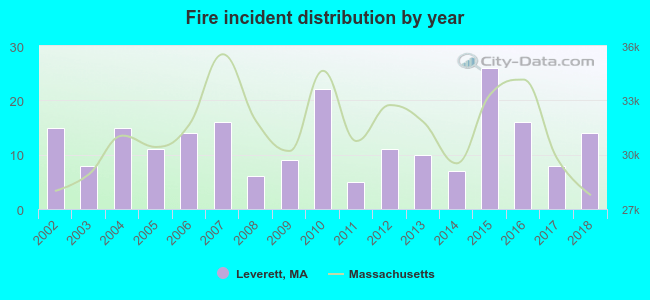 Based on the data from the years 2002 - 2018 the average number of fire incidents per year is 13. The highest number of fires - 26 took place in 2015, and the least - 5 in 2011. The data has a decreasing trend.
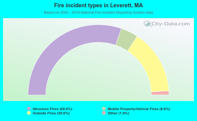 When looking into fire subcategories, the most reports belonged to: Structure Fires (60.6%), and Outside Fires (29.6%).
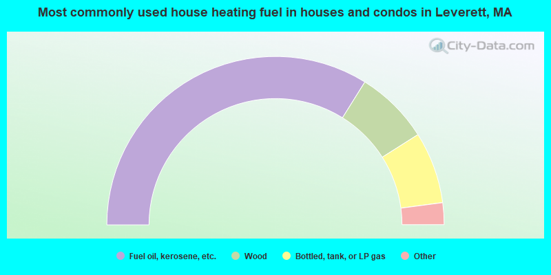
- 67.8%Fuel oil, kerosene, etc.
- 14.2%Wood
- 13.8%Bottled, tank, or LP gas
- 3.8%Electricity
- 0.4%Coal or coke
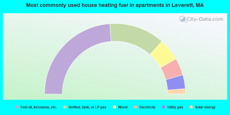
- 47.6%Fuel oil, kerosene, etc.
- 25.4%Bottled, tank, or LP gas
- 10.3%Wood
- 7.9%Electricity
- 6.3%Utility gas
- 2.4%Solar energy
Leverett compared to Massachusetts state average:
- Unemployed percentage significantly below state average.
- Black race population percentage significantly below state average.
- Hispanic race population percentage significantly below state average.
- Median age significantly above state average.
- Foreign-born population percentage significantly below state average.
- Renting percentage below state average.
- Length of stay since moving in significantly above state average.
- Number of rooms per house significantly below state average.
- House age significantly below state average.
- Percentage of population with a bachelor's degree or higher above state average.
Leverett on our top lists:
- #21 on the list of "Top 101 cities with the largest percentage of people in religious group quarters (population 1,000+)"
- #26 on the list of "Top 101 cities with the most people having Doctorate degrees (population 500+)"
- #73 on the list of "Top 101 cities with the most people having Master's or Doctorate degrees (population 500+)"
- #96 (01054) on the list of "Top 101 zip codes with the largest percentage of taxpayers reporting profit/loss from business in 2012 (pop 1,000+)"
- #21 on the list of "Top 101 counties with the highest percentage of residents that drank alcohol in the past 30 days"
- #65 on the list of "Top 101 counties with the lowest average weight of females"
- #84 on the list of "Top 101 counties with the lowest surface withdrawal of fresh water for public supply (pop. 50,000+)"
- #88 on the list of "Top 101 counties with the best general health status score of residents (1-5), 3 years of data"
- #92 on the list of "Top 101 counties with the highest percentage of residents that smoked 100+ cigarettes in their lives"

|
|
Total of 25 patent applications in 2008-2024.