Bridge Statistics for Levittown, Pennsylvania (PA)
Condition, Traffic, Stress, Structural Evaluation, Project Costs
- National Bridge Inventory (NBI) Statistics
- 72Number of bridges
- 991ft / 302mTotal length
- $11,848,000Total costs
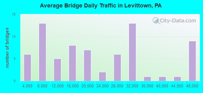
- 1,469,201Total average daily traffic
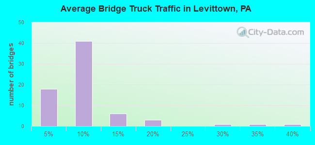
- 110,258Total average daily truck traffic
- National Bridge Inventory (NBI) Registered Bridges for Levittown
- No street view available for this location

- New bridges - historical statistics
- 11910-1919
- 11930-1939
- 11940-1949
- 131950-1959
- 51960-1969
- 251970-1979
- 51980-1989
- 212010-2019
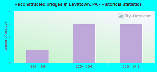
- Reconstructed bridges - Historical Statistics
- 11990-1999
- 32000-2009
- 32010-2019
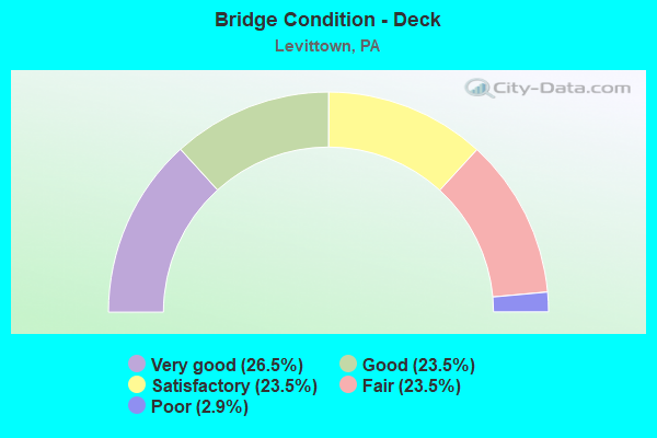
- Bridge Condition - Deck
- 26.5%Very good
- 23.5%Good
- 23.5%Satisfactory
- 23.5%Fair
- 2.9%Poor
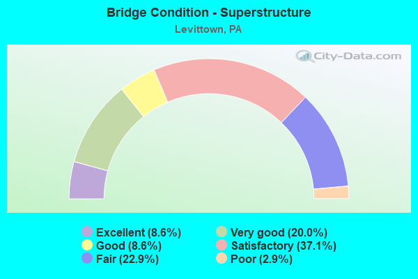
- Bridge Condition - Superstructure
- 8.6%Excellent
- 20.0%Very good
- 8.6%Good
- 37.1%Satisfactory
- 22.9%Fair
- 2.9%Poor
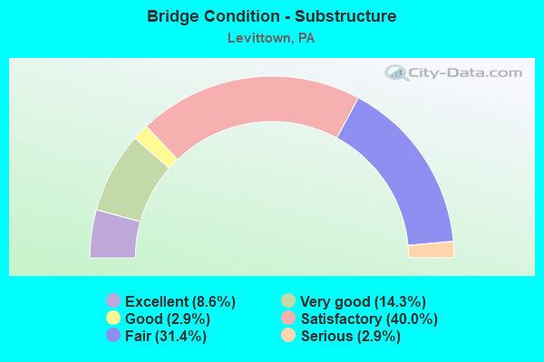
- Bridge Condition - Substructure
- 8.6%Excellent
- 14.3%Very good
- 2.9%Good
- 40.0%Satisfactory
- 31.4%Fair
- 2.9%Serious
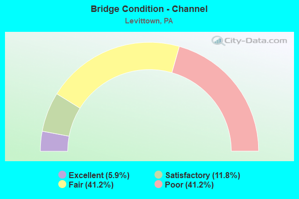
- Bridge Condition - Channel
- 5.9%Excellent
- 11.8%Satisfactory
- 41.2%Fair
- 41.2%Poor
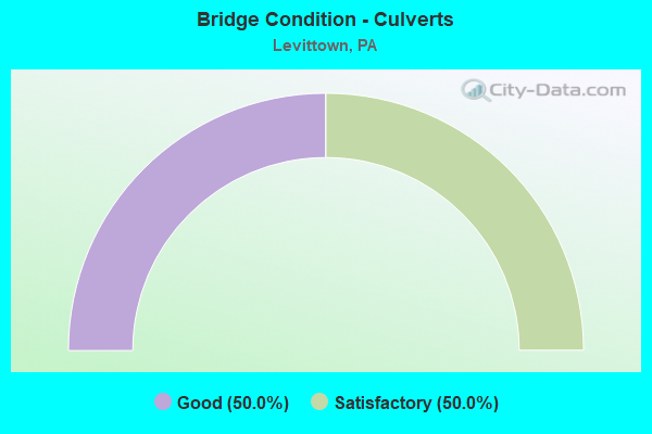
- Bridge Condition - Culverts
- 50.0%Good
- 50.0%Satisfactory
Find on map >> Show street view
Structure Number: 6742, Location: INTERC.WOOLSTON DR.38F07 (Lat: 40.194258, Lng: -74.824142), Route carried "under" structure: Spur State highway , Year Built: 1985, Structure Length: 0. m, Average Daily Traffic: 5,952 (year 2022), Truck Traffic: 5%, Features Intersected: WOOLSTON DRIVE, Facility Carried by Structure: NEW US-1 BY-PASS
Minimum Vertical Clearance: 4.75m (15.58ft), Kilometerpoint: 0.000, Lanes on structure: 2, Lanes under structure: 2, Material/Design: Prestressed concrete, Design/Construction: Box Beam or Girders - Single/Spread, Length of Maximum Span: 26.2m (86.0ft)
Find on map >> Show street view
Structure Number: 6742, Location: INTERC.WOOLSTON DR.38F07 (Lat: 40.194258, Lng: -74.824142), Route carried "under" structure: Spur State highway , Year Built: 1985, Structure Length: 0. m, Average Daily Traffic: 5,952 (year 2022), Truck Traffic: 5%, Features Intersected: WOOLSTON DRIVE, Facility Carried by Structure: NEW US-1 BY-PASS
Minimum Vertical Clearance: 4.44m (14.57ft), Kilometerpoint: 0.000, Lanes on structure: 2, Lanes under structure: 2, Material/Design: Prestressed concrete, Design/Construction: Box Beam or Girders - Single/Spread, Length of Maximum Span: 26.2m (86.0ft)
Find on map >> Show street view
Structure Number: 6743, Location: S.WOOLSTON DRIVE 38G07 (Lat: 40.194306, Lng: -74.817028), Route carried "under" structure: State highway , Year Built: 1985, Structure Length: 0. m, Average Daily Traffic: 7,089 (year 2022), Truck Traffic: 3%, Features Intersected: TRENTON AVENUE;RTE.1, Facility Carried by Structure: NEW US-1 BY-PASS
Minimum Vertical Clearance: 4.70m (15.42ft), Kilometerpoint: 0.439, Lanes on structure: 4, Lanes under structure: 4, Material/Design: Steel, Design/Construction: Stringer/Multi-beam, Length of Maximum Span: 52.1m (170.9ft)
Find on map >> Show street view
Structure Number: 6743, Location: S.WOOLSTON DRIVE 38G07 (Lat: 40.194306, Lng: -74.817028), Route carried "under" structure: State highway , Year Built: 1985, Structure Length: 0. m, Average Daily Traffic: 7,586 (year 2022), Truck Traffic: 3%, Features Intersected: TRENTON AVENUE;RTE.1, Facility Carried by Structure: NEW US-1 BY-PASS
Minimum Vertical Clearance: 4.57m (14.99ft), Kilometerpoint: 0.446, Lanes on structure: 4, Lanes under structure: 4, Material/Design: Steel, Design/Construction: Stringer/Multi-beam, Length of Maximum Span: 52.1m (170.9ft)
Find on map >> Show street view
Structure Number: 677, Location: NORTH TULLYTOWN 43H01 (Lat: 40.157753, Lng: -74.812100), Route carried "under" structure: County highway , Year Built: 1955, Structure Length: 0. m, Average Daily Traffic: 850 (year 1980), Truck Traffic: 7%, Features Intersected: MILL CREEK RD(T323), Facility Carried by Structure: TRAFFIC ROUTE 13
Minimum Vertical Clearance: 4.29m (14.07ft), Kilometerpoint: 0.000, Lanes on structure: 2, Lanes under structure: 2, Material/Design: Steel, Design/Construction: Stringer/Multi-beam, Length of Maximum Span: 11.0m (36.1ft)
Find on map >> Show street view
Structure Number: 6771, Location: NORTH TULLYTOWN 38H11 (Lat: 40.171422, Lng: -74.812397), Route carried "under" structure: State highway , Year Built: 1955, Structure Length: 0. m, Average Daily Traffic: 7,621 (year 2022), Truck Traffic: 5%, Features Intersected: PENN VALLEY ROAD, Facility Carried by Structure: TRAFFIC ROUTE 13
Minimum Vertical Clearance: 4.47m (14.67ft), Kilometerpoint: 1.479, Lanes on structure: 2, Lanes under structure: 2, Material/Design: Steel, Design/Construction: Stringer/Multi-beam, Length of Maximum Span: 23.2m (76.1ft)
Find on map >> Show street view
Structure Number: 6773, Location: 2MI.S.MORRISVILL 38H09 (Lat: 40.181164, Lng: -74.809058), Route carried "under" structure: State highway , Year Built: 1954, Structure Length: 0. m, Average Daily Traffic: 4,510 (year 2021), Truck Traffic: 26%, Features Intersected: TYBURN ROAD, Facility Carried by Structure: U.S. ROUTE 13
Minimum Vertical Clearance: 4.24m (13.91ft), Kilometerpoint: 1.939, Lanes on structure: 2, Lanes under structure: 2, Material/Design: Steel, Design/Construction: Stringer/Multi-beam, Length of Maximum Span: 22.9m (75.1ft)
Find on map >> Show street view
Structure Number: 6773, Location: 2MI.S.MORRISVILL 38H09 (Lat: 40.181164, Lng: -74.809058), Route carried "under" structure: State highway , Year Built: 1954, Structure Length: 0. m, Average Daily Traffic: 5,167 (year 2021), Truck Traffic: 38%, Features Intersected: TYBURN ROAD, Facility Carried by Structure: U.S. ROUTE 13
Minimum Vertical Clearance: 4.30m (14.11ft), Kilometerpoint: 1.923, Lanes on structure: 2, Lanes under structure: 2, Material/Design: Steel, Design/Construction: Stringer/Multi-beam, Length of Maximum Span: 22.9m (75.1ft)
Find on map >> Show street view
Structure Number: 6856, Location: NEWPORTVILLE 42G6/3262H10 (Lat: 40.128694, Lng: -74.889444), Route carried "under" structure: Interstate 276, Year Built: 1972, Structure Length: 0. m, Average Daily Traffic: 38,500 (year 1980), Truck Traffic: 7%, Features Intersected: PENNSYLVANIA TURNPIKE, Facility Carried by Structure: INTERSTATE 295 EB
Minimum Vertical Clearance: 5.18m (16.99ft), Kilometerpoint: 0.000, Lanes on structure: 2, Lanes under structure: 4, Material/Design: Steel, Design/Construction: Stringer/Multi-beam, Length of Maximum Span: 39.3m (128.9ft)
Find on map >> Show street view
Structure Number: 6857, Location: 1MI.N.NEWPORTVILLE 42G06 (Lat: 40.130314, Lng: -74.890092), Route carried "under" structure: State highway , Year Built: 1972, Structure Length: 0. m, Average Daily Traffic: 12,253 (year 2021), Truck Traffic: 4%, Features Intersected: NEW FALLS ROAD/ 3262-H10, Facility Carried by Structure: INTERSTATE 295 EB
Minimum Vertical Clearance: 5.03m (16.50ft), Kilometerpoint: 1.081, Lanes on structure: 2, Lanes under structure: 2, Material/Design: Prestressed concrete, Design/Construction: Stringer/Multi-beam, Length of Maximum Span: 26.2m (86.0ft)
Find on map >> Show street view
Structure Number: 6858, Location: NEWPORTVILLE 42G6/3262H10 (Lat: 40.128781, Lng: -74.889797), Route carried "under" structure: Interstate 276, Year Built: 1972, Structure Length: 0. m, Average Daily Traffic: 33,500 (year 1980), Truck Traffic: 7%, Features Intersected: PENNSYLVANIA TURNPIKE, Facility Carried by Structure: INTERSTATE 295 WB
Minimum Vertical Clearance: 5.79m (19.00ft), Kilometerpoint: 0.000, Lanes on structure: 2, Lanes under structure: 4, Material/Design: Steel, Design/Construction: Stringer/Multi-beam, Length of Maximum Span: 39.3m (128.9ft)
Find on map >> Show street view
Structure Number: 6859, Location: 1MI.N.NEWPORTVILLE 42G06 (Lat: 40.130203, Lng: -74.890372), Route carried "under" structure: State highway , Year Built: 1972, Structure Length: 0. m, Average Daily Traffic: 12,253 (year 2021), Truck Traffic: 4%, Features Intersected: NEW FALLS ROAD/ 3262-H10, Facility Carried by Structure: INTERSTATE 295 WB
Minimum Vertical Clearance: 4.42m (14.50ft), Kilometerpoint: 1.081, Lanes on structure: 2, Lanes under structure: 2, Material/Design: Prestressed concrete, Design/Construction: Stringer/Multi-beam, Length of Maximum Span: 26.2m (86.0ft)
Find on map >> Show street view
Structure Number: 6862, Location: FAIRLESS JUNCTION 37E11 (Lat: 40.169031, Lng: -74.899172), Route carried "under" structure: State highway , Year Built: 1972, Structure Length: 0. m, Average Daily Traffic: 950 (year 1980), Truck Traffic: 10%, Features Intersected: FLOWERS MILL ROAD(T344), Facility Carried by Structure: INTERSTATE 295(EB)
Minimum Vertical Clearance: 4.44m (14.57ft), Kilometerpoint: 0.000, Lanes on structure: 3, Lanes under structure: 2, Material/Design: Prestressed concrete, Design/Construction: Stringer/Multi-beam, Length of Maximum Span: 20.1m (65.9ft)
Find on map >> Show street view
Structure Number: 6863, Location: FAIRLESS JUNCTION 37E11 (Lat: 40.169617, Lng: -74.899306), Route carried "under" structure: State highway , Year Built: 1972, Structure Length: 0. m, Average Daily Traffic: 950 (year 1980), Truck Traffic: 10%, Features Intersected: FLOWERS MILL ROAD(T344), Facility Carried by Structure: INTERSTATE 295(WB)
Minimum Vertical Clearance: 4.57m (14.99ft), Kilometerpoint: 0.000, Lanes on structure: 3, Lanes under structure: 2, Material/Design: Prestressed concrete, Design/Construction: Stringer/Multi-beam, Length of Maximum Span: 20.1m (65.9ft)
Find on map >> Show street view
Structure Number: 6947, Location: FAIRLESS JUNCTION 37E10 (Lat: 40.176706, Lng: -74.896508), Route carried "under" structure: Interstate 295, Year Built: 1972, Structure Length: 0. m, Average Daily Traffic: 24,405 (year 2021), Truck Traffic: 6%, Features Intersected: I-295,CSX,SEPTA, Facility Carried by Structure: OLD LINCOLN HIGHWY
Minimum Vertical Clearance: 6.81m (22.34ft), Kilometerpoint: 5.633, Lanes on structure: 2, Lanes under structure: 2, Material/Design: Prestressed concrete, Design/Construction: Stringer/Multi-beam, Length of Maximum Span: 28.0m (91.9ft)
Find on map >> Show street view
Structure Number: 6947, Location: FAIRLESS JUNCTION 37E10 (Lat: 40.176706, Lng: -74.896508), Route carried "under" structure: Interstate 295, Year Built: 1972, Structure Length: 0. m, Average Daily Traffic: 25,069 (year 2021), Truck Traffic: 6%, Features Intersected: I-295,CSX,SEPTA, Facility Carried by Structure: OLD LINCOLN HIGHWY
Minimum Vertical Clearance: 6.96m (22.83ft), Kilometerpoint: 5.633, Lanes on structure: 2, Lanes under structure: 2, Material/Design: Prestressed concrete, Design/Construction: Stringer/Multi-beam, Length of Maximum Span: 28.0m (91.9ft)
Find on map >> Show street view
Structure Number: 702, Location: NORTH OF PENNDEL 37E12 (Lat: 40.165839, Lng: -74.900267), Route carried "under" structure: Interstate 295, Year Built: 1972, Structure Length: 0. m, Average Daily Traffic: 24,405 (year 2021), Truck Traffic: 6%, Features Intersected: INTERSTATE 295, Facility Carried by Structure: LINCOLN HIGHWAY
Minimum Vertical Clearance: 5.79m (19.00ft), Kilometerpoint: 4.828, Lanes on structure: 2, Lanes under structure: 2, Material/Design: Steel continuous, Design/Construction: Stringer/Multi-beam, Length of Maximum Span: 41.8m (137.1ft)
Find on map >> Show street view
Structure Number: 702, Location: NORTH OF PENNDEL 37E12 (Lat: 40.165839, Lng: -74.900267), Route carried "under" structure: Interstate 295, Year Built: 1972, Structure Length: 0. m, Average Daily Traffic: 25,069 (year 2021), Truck Traffic: 6%, Features Intersected: INTERSTATE 295, Facility Carried by Structure: LINCOLN HIGHWAY
Minimum Vertical Clearance: 5.10m (16.73ft), Kilometerpoint: 4.828, Lanes on structure: 2, Lanes under structure: 2, Material/Design: Steel continuous, Design/Construction: Stringer/Multi-beam, Length of Maximum Span: 41.8m (137.1ft)
Find on map >> Show street view
Structure Number: 7178, Location: 1.7MI.N.PENNA TPK. 42E02 (Lat: 40.152464, Lng: -74.899053), Route carried "under" structure: Interstate 295, Year Built: 1968, Structure Length: 0. m, Average Daily Traffic: 29,502 (year 2021), Truck Traffic: 6%, Features Intersected: INTERSTATE 295, Facility Carried by Structure: TRENTON ROAD
Minimum Vertical Clearance: 4.99m (16.37ft), Kilometerpoint: 3.219, Lanes on structure: 2, Lanes under structure: 2, Material/Design: Steel continuous, Design/Construction: Stringer/Multi-beam, Length of Maximum Span: 32.3m (106.0ft)
Find on map >> Show street view
Structure Number: 7178, Location: 1.7MI.N.PENNA TPK. 42E02 (Lat: 40.152464, Lng: -74.899053), Route carried "under" structure: Interstate 295, Year Built: 1968, Structure Length: 0. m, Average Daily Traffic: 30,812 (year 2021), Truck Traffic: 6%, Features Intersected: INTERSTATE 295, Facility Carried by Structure: TRENTON ROAD
Minimum Vertical Clearance: 5.15m (16.90ft), Kilometerpoint: 3.219, Lanes on structure: 2, Lanes under structure: 2, Material/Design: Steel continuous, Design/Construction: Stringer/Multi-beam, Length of Maximum Span: 32.3m (106.0ft)
Find on map >> Show street view
Structure Number: 7283, Location: E.PENNDEL BOROUGH 42E01 (Lat: 40.157594, Lng: -74.900303), Route carried "under" structure: Interstate 295, Year Built: 1972, Structure Length: 0. m, Average Daily Traffic: 29,502 (year 2021), Truck Traffic: 6%, Features Intersected: INTERSTATE 295, Facility Carried by Structure: DURHAM ROAD
Minimum Vertical Clearance: 5.05m (16.57ft), Kilometerpoint: 4.023, Lanes on structure: 2, Lanes under structure: 2, Material/Design: Steel continuous, Design/Construction: Stringer/Multi-beam, Length of Maximum Span: 34.7m (113.8ft)
Find on map >> Show street view
Structure Number: 7283, Location: E.PENNDEL BOROUGH 42E01 (Lat: 40.157594, Lng: -74.900303), Route carried "under" structure: Interstate 295, Year Built: 1972, Structure Length: 0. m, Average Daily Traffic: 30,812 (year 2021), Truck Traffic: 6%, Features Intersected: INTERSTATE 295, Facility Carried by Structure: DURHAM ROAD
Minimum Vertical Clearance: 5.05m (16.57ft), Kilometerpoint: 4.023, Lanes on structure: 2, Lanes under structure: 2, Material/Design: Steel continuous, Design/Construction: Stringer/Multi-beam, Length of Maximum Span: 34.7m (113.8ft)
Find on map >> Show street view
Structure Number: 46421, Location: NEAR BRISTOL 3263B10 (Lat: 40.125233, Lng: -74.864772), Route carried "under" structure: Interstate 276, Year Built: 2011, Structure Length: 0. m, Average Daily Traffic: 46,280 (year 2004), Truck Traffic: 15%, Features Intersected: PA TURNPIKE (I-276), Facility Carried by Structure: BRISTOL-OXFORD VA
Minimum Vertical Clearance: 5.28m (17.32ft), Kilometerpoint: 0.000, Lanes on structure: 2, Lanes under structure: 5, Toll: On toll road, Material/Design: Prestressed concrete continuous, Design/Construction: Box Beam or Girders - Single/Spread, Length of Maximum Span: 27.7m (90.9ft)
Find on map >> Show street view
Structure Number: 48164, Location: .6 MI. S. PA TPK. 3374H01 (Lat: 40.120597, Lng: -74.888033), Route carried "under" structure: Interstate 95, Year Built: 2013, Structure Length: 0. m, Average Daily Traffic: 44,587 (year 2021), Truck Traffic: 7%, Features Intersected: INTERSTATE 95, Facility Carried by Structure: FORD ROAD (T323)
Minimum Vertical Clearance: 5.49m (18.01ft), Kilometerpoint: 10.429, Lanes on structure: 2, Lanes under structure: 2, Material/Design: Steel continuous, Design/Construction: Stringer/Multi-beam, Length of Maximum Span: 46.6m (152.9ft)
Find on map >> Show street view
Structure Number: 48164, Location: .6 MI. S. PA TPK. 3374H01 (Lat: 40.120597, Lng: -74.888033), Route carried "under" structure: Interstate 95, Year Built: 2013, Structure Length: 0. m, Average Daily Traffic: 44,372 (year 2021), Truck Traffic: 8%, Features Intersected: INTERSTATE 95, Facility Carried by Structure: FORD ROAD (T323)
Minimum Vertical Clearance: 5.13m (16.83ft), Kilometerpoint: 10.441, Lanes on structure: 2, Lanes under structure: 2, Material/Design: Steel continuous, Design/Construction: Stringer/Multi-beam, Length of Maximum Span: 46.6m (152.9ft)
Find on map >> Show street view
Structure Number: 48164, Location: .6 MI. S. PA TPK. 3374H01 (Lat: 40.120597, Lng: -74.888033), Route carried "under" structure: Interstate 295, Year Built: 2013, Structure Length: 0. m, Average Daily Traffic: 28,772 (year 2018), Truck Traffic: 7%, Features Intersected: INTERSTATE 95, Facility Carried by Structure: FORD ROAD (T323)
Minimum Vertical Clearance: 5.39m (17.68ft), Kilometerpoint: 0.000, Lanes on structure: 2, Lanes under structure: 2, Material/Design: Steel continuous, Design/Construction: Stringer/Multi-beam, Length of Maximum Span: 46.6m (152.9ft)
Find on map >> Show street view
Structure Number: 53664, Location: Near Newportville (Lat: 40.128000, Lng: -74.883806), Route carried "under" structure: State highway , Year Built: 2016, Structure Length: 0. m, Average Daily Traffic: 7,584 (year 2022), Truck Traffic: 3%, Features Intersected: SR 2049, Durham Rd., Facility Carried by Structure: PA TPK (I-276)
Minimum Vertical Clearance: 4.70m (15.42ft), Kilometerpoint: 1.873, Lanes on structure: 7, Lanes under structure: 3, Material/Design: Prestressed concrete, Design/Construction: Stringer/Multi-beam, Length of Maximum Span: 36.0m (118.1ft)
Find on map >> Show street view
Structure Number: 53665, Location: 1.5 M West Exit 358 (Lat: 40.127472, Lng: -74.880483), Route carried "under" structure: State highway 413, Year Built: 2016, Structure Length: 0. m, Average Daily Traffic: 17,656 (year 2022), Truck Traffic: 7%, Features Intersected: SR 0413 New Rodgers Rd., Facility Carried by Structure: PA TPK (I-276)
Minimum Vertical Clearance: 5.05m (16.57ft), Kilometerpoint: 5.094, Lanes on structure: 7, Lanes under structure: 2, Material/Design: Prestressed concrete, Design/Construction: Stringer/Multi-beam, Length of Maximum Span: 31.7m (104.0ft)
Find on map >> Show street view
Structure Number: 5503, Location: NEAR PA TURNPIKE 3262H10 (Lat: 40.124956, Lng: -74.888167), Route carried "under" structure: State highway 413, Year Built: 2018, Structure Length: 0. m, Average Daily Traffic: 17,656 (year 2022), Truck Traffic: 7%, Features Intersected: RMP-G,I-276,SR2049 & 413, Facility Carried by Structure: I-95 (NB)
Minimum Vertical Clearance: 14.80m (48.56ft), Kilometerpoint: 5.094, Lanes on structure: 2, Lanes under structure: 2, Material/Design: Prestressed concrete continuous, Design/Construction: Stringer/Multi-beam, Length of Maximum Span: 68.6m (225.1ft)
Find on map >> Show street view
Structure Number: 5503, Location: NEAR PA TURNPIKE 3262H10 (Lat: 40.124956, Lng: -74.888167), Route carried "under" structure: State highway , Year Built: 2018, Structure Length: 0. m, Average Daily Traffic: 7,584 (year 2022), Truck Traffic: 3%, Features Intersected: RMP-G,I-276,SR2049 & 413, Facility Carried by Structure: I-95 (NB)
Minimum Vertical Clearance: 14.10m (46.26ft), Kilometerpoint: 1.873, Lanes on structure: 2, Lanes under structure: 2, Material/Design: Prestressed concrete continuous, Design/Construction: Stringer/Multi-beam, Length of Maximum Span: 68.6m (225.1ft)
Find on map >> Show street view
Structure Number: 55031, Location: NEAR I-276 3262H10 (Lat: 40.125867, Lng: -74.888806), Route carried "under" structure: State highway , Year Built: 2018, Structure Length: 0. m, Average Daily Traffic: 7,584 (year 2022), Truck Traffic: 3%, Features Intersected: I295&276;RP B,E,F,G,2049, Facility Carried by Structure: I-95 SB
Minimum Vertical Clearance: 10.36m (33.99ft), Kilometerpoint: 1.873, Lanes on structure: 2, Lanes under structure: 2, Material/Design: Prestressed concrete continuous, Design/Construction: Stringer/Multi-beam, Length of Maximum Span: 68.6m (225.1ft)
Find on map >> Show street view
Structure Number: 55031, Location: NEAR I-276 3262H10 (Lat: 40.125867, Lng: -74.888806), Route carried "under" structure: State highway 413, Year Built: 2018, Structure Length: 0. m, Average Daily Traffic: 17,704 (year 2018), Truck Traffic: 7%, Features Intersected: I295&276;RP B,E,F,G,2049, Facility Carried by Structure: I-95 SB
Minimum Vertical Clearance: 6.27m (20.57ft), Kilometerpoint: 5.086, Lanes on structure: 2, Lanes under structure: 4, Material/Design: Prestressed concrete continuous, Design/Construction: Stringer/Multi-beam, Length of Maximum Span: 68.6m (225.1ft)
Find on map >> Show street view
Structure Number: 55031, Location: NEAR I-276 3262H10 (Lat: 40.125867, Lng: -74.888806), Route carried "under" structure: Interstate 295, Year Built: 2018, Structure Length: 0. m, Average Daily Traffic: 29,502 (year 2021), Truck Traffic: 6%, Features Intersected: I295&276;RP B,E,F,G,2049, Facility Carried by Structure: I-95 SB
Minimum Vertical Clearance: 9.88m (32.41ft), Kilometerpoint: 0.000, Lanes on structure: 2, Lanes under structure: 2, Material/Design: Prestressed concrete continuous, Design/Construction: Stringer/Multi-beam, Length of Maximum Span: 68.6m (225.1ft)
Find on map >> Show street view
Structure Number: 55031, Location: NEAR I-276 3262H10 (Lat: 40.125867, Lng: -74.888806), Route carried "under" structure: Interstate 295, Year Built: 2018, Structure Length: 0. m, Average Daily Traffic: 30,812 (year 2021), Truck Traffic: 6%, Features Intersected: I295&276;RP B,E,F,G,2049, Facility Carried by Structure: I-95 SB
Minimum Vertical Clearance: 6.27m (20.57ft), Kilometerpoint: 0.000, Lanes on structure: 2, Lanes under structure: 2, Material/Design: Prestressed concrete continuous, Design/Construction: Stringer/Multi-beam, Length of Maximum Span: 68.6m (225.1ft)
Find on map >> Show street view
Structure Number: 55778, Location: .5 MI. EAST I-295 3262J10 (Lat: 40.128464, Lng: -74.882431), Route carried "under" structure: State highway 413, Year Built: 2018, Structure Length: 0. m, Average Daily Traffic: 17,656 (year 2022), Truck Traffic: 7%, Features Intersected: NEW RODGERS ROAD (PA413), Facility Carried by Structure: I-95 SB
Minimum Vertical Clearance: 7.77m (25.49ft), Kilometerpoint: 5.094, Lanes on structure: 2, Lanes under structure: 2, Material/Design: Prestressed concrete continuous, Design/Construction: Stringer/Multi-beam, Length of Maximum Span: 31.4m (103.0ft)