Bridge Statistics for Lincoln, Nebraska (NE)
Condition, Traffic, Stress, Structural Evaluation, Project Costs
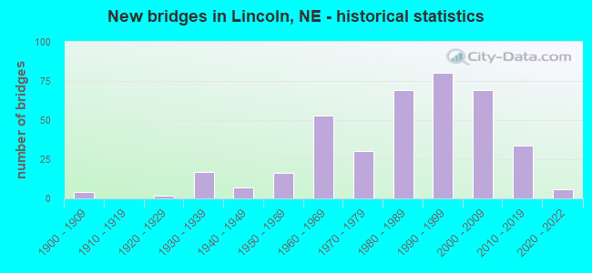
- New bridges - historical statistics
- 41900-1909
- 21920-1929
- 171930-1939
- 71940-1949
- 161950-1959
- 531960-1969
- 301970-1979
- 691980-1989
- 801990-1999
- 692000-2009
- 342010-2019
- 62020-2022
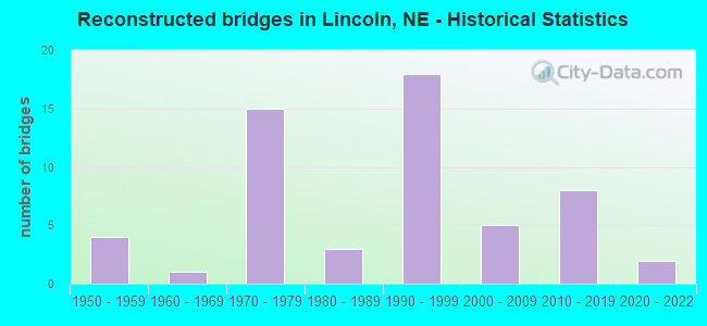
- Reconstructed bridges - Historical Statistics
- 41950-1959
- 11960-1969
- 151970-1979
- 31980-1989
- 181990-1999
- 52000-2009
- 82010-2019
- 22020-2022
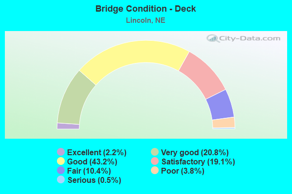
- Bridge Condition - Deck
- 2.2%Excellent
- 20.8%Very good
- 43.2%Good
- 19.1%Satisfactory
- 10.4%Fair
- 3.8%Poor
- 0.5%Serious
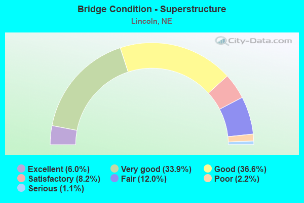
- Bridge Condition - Superstructure
- 6.0%Excellent
- 33.9%Very good
- 36.6%Good
- 8.2%Satisfactory
- 12.0%Fair
- 2.2%Poor
- 1.1%Serious
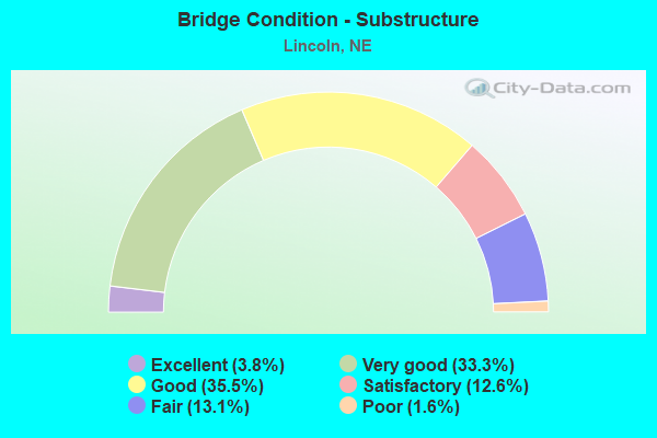
- Bridge Condition - Substructure
- 3.8%Excellent
- 33.3%Very good
- 35.5%Good
- 12.6%Satisfactory
- 13.1%Fair
- 1.6%Poor
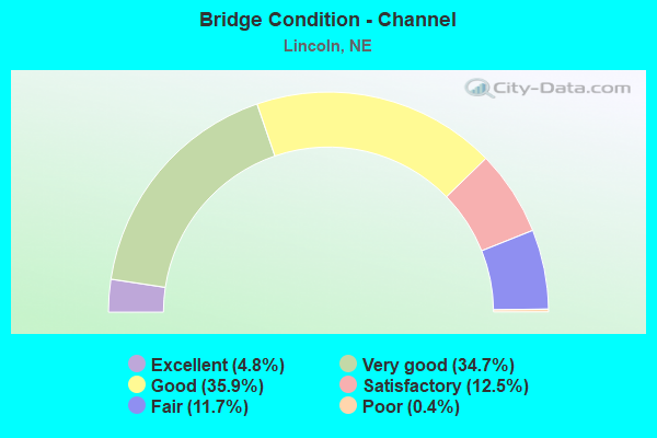
- Bridge Condition - Channel
- 4.8%Excellent
- 34.7%Very good
- 35.9%Good
- 12.5%Satisfactory
- 11.7%Fair
- 0.4%Poor
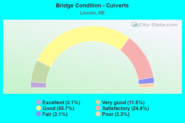
- Bridge Condition - Culverts
- 3.1%Excellent
- 11.5%Very good
- 55.7%Good
- 24.4%Satisfactory
- 3.1%Fair
- 2.3%Poor
Find on map >> Show street view
Structure Number: U1425I2405, Location: AIR PARK RD @ NW41ST (Lat: 40.855500, Lng: -96.779700), Route carried "on" structure: City street 5203, Year Built: 1999, Status: Open, Structure Length: 5.55m (18.21ft), Average Daily Traffic: 1,100 (year 2002), Average Future Daily Traffic: 1,100 (year 2033), Features Intersected: OAK CREEK
Minimum Vertical Clearance: 30+ m (98+ ft), Kilometerpoint: 16.246, Lanes on structure: 2, Owner: City or Municipal Highway Agency, Approaching Roadway Width: 9.1m (29.9ft), Material/Design: Steel continuous, Design/Construction: Stringer/Multi-beam, Number Of Spans In Main Unit: 3, Length of Maximum Span: 21.3m (69.9ft), Curb or Sidewalk Widths: Left: 0.0m, Right: 1.5m (4.9ft), Curb-To-Curb Width: 9.1m (29.9ft), Out-to-Out Width: 11.3m (37.1ft)
Condition: Deck: Satisfactory, Superstructure: Good, Substructure: Good, Channel: Very good, Operating Rating: 66.0 metric tons, Method Used To Determine Operating Rating: Load Factor (LF), Inventory Rating: 40.0 metric tons, Method Used To Determine Inventory Rating: Load Factor (LF), Structural Evaluation: Better than present minimum criteria, Deck Geometry: Somewhat better than minimum adequacy, Waterway Adequacy: Equal to present desirable criteria, Approach Roadway Alignment: Equal to present desirable criteria, Length Of Structure Improvement: 4.30m (14.11ft), Designated Inspection Frequency: Every 24 months, Inspection Date: December 2020, Deck Structure Type: Concrete Cast-file-Place, Wearing Surface/Protective System: Wearing Surface: Monolithic Concrete, Deck Protection: Epoxy Coated Reinforcing
Find on map >> Show street view
Structure Number: U1425I283, Location: FAIRFIELD ST @ N 27TH ST (Lat: 40.847600, Lng: -96.684600), Route carried "on" structure: City street 5252, Year Built: 1978, Status: Open, Structure Length: 0.70m (2.30ft), Average Daily Traffic: 6,860 (year 2015), Truck Traffic: 1%, Average Future Daily Traffic: 7,000 (year 2035), Design Load: HS 20, Features Intersected: STREAM, Facility Carried by Structure: FAIRFIELD ST
Minimum Vertical Clearance: 30+ m (98+ ft), Kilometerpoint: 16.214, Lanes on structure: 3, Owner: City or Municipal Highway Agency, Approaching Roadway Width: 13.4m (44.0ft), Skew: 4 degrees, Material/Design: Concrete, Design/Construction: Culvert, Number Of Spans In Main Unit: 2, Length of Maximum Span: 2.4m (7.9ft), Curb-To-Curb Width: 13.4m (44.0ft), Out-to-Out Width: 13.7m (44.9ft)
Condition: Channel: Very good, Culverts: Satisfactory, Operating Rating: 33.0 metric tons, Method Used To Determine Operating Rating: Field evaluation and documented engineering judgment, Inventory Rating: 22.0 metric tons, Method Used To Determine Inventory Rating: Field evaluation and documented engineering judgment, Structural Evaluation: Somewhat better than minimum adequacy, Deck Geometry: Somewhat better than minimum adequacy, Waterway Adequacy: Equal to present desirable criteria, Approach Roadway Alignment: Equal to present desirable criteria, Designated Inspection Frequency: Every 24 months, Inspection Date: November 2020
Find on map >> Show street view
Structure Number: U1425I2905, Location: LINCOLN COTNER @ VINE (Lat: 40.821300, Lng: -96.634200), Route carried "on" structure: City street 5237, Year Built: 1960, Year Reconstructed: 1997, Status: Open, Structure Length: 1.68m (5.51ft), Average Daily Traffic: 8,350 (year 2016), Truck Traffic: 1%, Average Future Daily Traffic: 9,000 (year 2033), Features Intersected: DEAD MANS RUN, Facility Carried by Structure: COTNER BLVD
Minimum Vertical Clearance: 30+ m (98+ ft), Kilometerpoint: 16.497, Lanes on structure: 5, Owner: City or Municipal Highway Agency, Approaching Roadway Width: 16.8m (55.1ft), Skew: 2 degrees, Material/Design: Prestressed concrete, Design/Construction: Stringer/Multi-beam, Number Of Spans In Main Unit: 1, Length of Maximum Span: 15.5m (50.9ft), Curb or Sidewalk Widths: Left: 2.1m (6.9ft), Right: 0.0m, Curb-To-Curb Width: 16.8m (55.1ft), Out-to-Out Width: 20.9m (68.6ft)
Condition: Deck: Satisfactory, Superstructure: Good, Substructure: Good, Channel: Good, Operating Rating: 65.0 metric tons, Method Used To Determine Operating Rating: Load Factor (LF), Inventory Rating: 33.0 metric tons, Method Used To Determine Inventory Rating: Load Factor (LF), Structural Evaluation: Better than present minimum criteria, Deck Geometry: High priority of replacement, Waterway Adequacy: Equal to present desirable criteria, Approach Roadway Alignment: Equal to present desirable criteria, Designated Inspection Frequency: Every 24 months, Inspection Date: December 2020, Deck Structure Type: Concrete Cast-file-Place, Wearing Surface/Protective System: Wearing Surface: Monolithic Concrete, Deck Protection: Epoxy Coated Reinforcing
Find on map >> Show street view
Structure Number: U1425I322, Location: U ST @ N 22ND ST (Lat: 40.820000, Lng: -96.688300), Route carried "on" structure: City street I32, Year Built: 1909, Year Reconstructed: 1996, Status: Open, Structure Length: 1.10m (3.61ft), Average Daily Traffic: 150 (year 2003), Truck Traffic: 1%, Average Future Daily Traffic: 217 (year 2033), Features Intersected: ANTELOPE CREEK, Facility Carried by Structure: U ST
Minimum Vertical Clearance: 30+ m (98+ ft), Kilometerpoint: 0.000, Lanes on structure: 2, Owner: City or Municipal Highway Agency, Approaching Roadway Width: 7.6m (24.9ft), Skew: 5 degrees, Material/Design: Concrete, Design/Construction: Culvert, Number Of Spans In Main Unit: 2, Length of Maximum Span: 2.7m (8.9ft), Curb-To-Curb Width: 7.6m (24.9ft), Out-to-Out Width: 7.9m (25.9ft)
Condition: Channel: Very good, Culverts: Satisfactory, Operating Rating: 33.0 metric tons, Method Used To Determine Operating Rating: Field evaluation and documented engineering judgment, Inventory Rating: 22.0 metric tons, Method Used To Determine Inventory Rating: Field evaluation and documented engineering judgment, Structural Evaluation: Equal to present minimum criteria, Deck Geometry: Somewhat better than minimum adequacy, Waterway Adequacy: Equal to present desirable criteria, Approach Roadway Alignment: Equal to present minimum criteria, Designated Inspection Frequency: Every 24 months, Inspection Date: September 2020
Find on map >> Show street view
Structure Number: U1425I3435, Location: ENGLEWOOD DR @ LAKEWOOD (Lat: 40.805000, Lng: -96.616700), Route carried "on" structure: City street I34, Year Built: 1983, Status: Open, Structure Length: 0.98m (3.22ft), Average Daily Traffic: 450 (year 2020), Truck Traffic: 1%, Average Future Daily Traffic: 507 (year 2040), Design Load: HS 20, Features Intersected: STREAM, Facility Carried by Structure: ENGLEWOOD DRIVE
Minimum Vertical Clearance: 30+ m (98+ ft), Kilometerpoint: 0.000, Lanes on structure: 2, Owner: City or Municipal Highway Agency, Approaching Roadway Width: 7.9m (25.9ft), Material/Design: Concrete, Design/Construction: Culvert, Number Of Spans In Main Unit: 3, Length of Maximum Span: 3.0m (9.8ft), Curb-To-Curb Width: 7.9m (25.9ft), Out-to-Out Width: 8.2m (26.9ft)
Condition: Channel: Very good, Culverts: Good, Operating Rating: 33.0 metric tons, Method Used To Determine Operating Rating: Field evaluation and documented engineering judgment, Inventory Rating: 22.0 metric tons, Method Used To Determine Inventory Rating: Field evaluation and documented engineering judgment, Structural Evaluation: Equal to present minimum criteria, Deck Geometry: Somewhat better than minimum adequacy, Waterway Adequacy: Equal to present desirable criteria, Approach Roadway Alignment: Better than present minimum criteria, Designated Inspection Frequency: Every 24 months, Inspection Date: November 2020
Find on map >> Show street view
Structure Number: U1425J2305, Location: SOUTHWOOD DR @ N2 (Lat: 40.767500, Lng: -96.689800), Route carried "on" structure: City street 5229, Year Built: 1972, Status: Open, Structure Length: 1.55m (5.09ft), Average Daily Traffic: 3,230 (year 2016), Average Future Daily Traffic: 3,400 (year 2036), Features Intersected: BEAL SLOUGH
Minimum Vertical Clearance: 30+ m (98+ ft), Kilometerpoint: 16.280, Lanes on structure: 2, Owner: City or Municipal Highway Agency, Approaching Roadway Width: 8.5m (27.9ft), Material/Design: Concrete, Design/Construction: Culvert, Number Of Spans In Main Unit: 4, Length of Maximum Span: 3.7m (12.1ft)
Condition: Channel: Satisfactory, Culverts: Poor, Operating Rating: 33.0 metric tons, Method Used To Determine Operating Rating: Field evaluation and documented engineering judgment, Inventory Rating: 22.0 metric tons, Method Used To Determine Inventory Rating: Field evaluation and documented engineering judgment, Structural Evaluation: Meets minimum limits, Waterway Adequacy: Equal to present minimum criteria, Approach Roadway Alignment: Better than present minimum criteria, Designated Inspection Frequency: Every 24 months, Inspection Date: March 2020
Find on map >> Show street view
Structure Number: U1425J2905, Location: N14TH ST MILITARY RD (Lat: 40.830800, Lng: -96.699700), Route carried "on" structure: City street J29, Year Built: 2006, Status: Open, Structure Length: 5.46m (17.91ft), Average Daily Traffic: 1,500 (year 2006), Truck Traffic: 2%, Average Future Daily Traffic: 1,700 (year 2026), Design Load: HS 25 or greater, Features Intersected: ANTELOPE CREEK, Facility Carried by Structure: STATE FAIR PARK DR
Minimum Vertical Clearance: 30+ m (98+ ft), Kilometerpoint: 0.000, Lanes on structure: 5, Owner: City or Municipal Highway Agency, Approaching Roadway Width: 18.9m (62.0ft), Skew: 3 degrees, Material/Design: Prestressed concrete continuous, Design/Construction: Slab, Number Of Spans In Main Unit: 3, Length of Maximum Span: 21.6m (70.9ft), Curb or Sidewalk Widths: Left: 4.0m (13.1ft), Right: 3.4m (11.2ft), Curb-To-Curb Width: 18.9m (62.0ft), Out-to-Out Width: 27.1m (88.9ft)
Condition: Deck: Good, Superstructure: Good, Substructure: Good, Channel: Very good, Operating Rating: 42.0 metric tons, Method Used To Determine Operating Rating: Load Factor (LF), Inventory Rating: 33.0 metric tons, Method Used To Determine Inventory Rating: Load Factor (LF), Structural Evaluation: Better than present minimum criteria, Deck Geometry: Meets minimum limits, Waterway Adequacy: Equal to present desirable criteria, Approach Roadway Alignment: Equal to present desirable criteria, Designated Inspection Frequency: Every 24 months, Inspection Date: August 2020, Deck Structure Type: Concrete Cast-file-Place, Wearing Surface/Protective System: Wearing Surface: Monolithic Concrete, Deck Protection: Epoxy Coated Reinforcing
Find on map >> Show street view
Structure Number: U1425J425, Location: .2S 56TH & OLD CHENEY (Lat: 40.751400, Lng: -96.645300), Route carried "on" structure: City street J42, Year Built: 2003, Status: Open, Structure Length: 1.34m (4.40ft), Average Daily Traffic: 100 (year 2008), Average Future Daily Traffic: 150 (year 2033), Design Load: HS 20, Features Intersected: BEAL SLOUGH, Facility Carried by Structure: WALTD RD
Minimum Vertical Clearance: 30+ m (98+ ft), Kilometerpoint: 0.000, Lanes on structure: 2, Owner: Private, Approaching Roadway Width: 5.8m (19.0ft), Material/Design: Concrete, Design/Construction: Culvert, Number Of Spans In Main Unit: 3, Length of Maximum Span: 4.3m (14.1ft), Curb or Sidewalk Widths: Left: 1.5m (4.9ft), Right: 0.0m
Condition: Channel: Good, Culverts: Satisfactory, Operating Rating: 42.0 metric tons, Method Used To Determine Operating Rating: Field evaluation and documented engineering judgment, Inventory Rating: 33.0 metric tons, Method Used To Determine Inventory Rating: Field evaluation and documented engineering judgment, Structural Evaluation: Equal to present minimum criteria, Waterway Adequacy: Equal to present desirable criteria, Approach Roadway Alignment: Superior to present desirable criteria, Designated Inspection Frequency: Every 24 months, Inspection Date: March 2019
Find on map >> Show street view
Structure Number: U1425J5515, Location: BETTY LOU & GLYNOAKES (Lat: 40.761900, Lng: -96.609700), Route carried "on" structure: City street J55, Year Built: 2010, Status: Open, Structure Length: 1.16m (3.81ft), Average Daily Traffic: 2,000 (year 2021), Average Future Daily Traffic: 2,000 (year 2041), Design Load: HS 20, Features Intersected: ANTELOPE CREEK, Facility Carried by Structure: GLYNOAKS DRIVE
Minimum Vertical Clearance: 30+ m (98+ ft), Kilometerpoint: 0.000, Lanes on structure: 2, Owner: City or Municipal Highway Agency, Approaching Roadway Width: 7.9m (25.9ft), Material/Design: Concrete, Design/Construction: Culvert, Number Of Spans In Main Unit: 3, Length of Maximum Span: 3.7m (12.1ft)
Condition: Channel: Very good, Culverts: Good, Operating Rating: 42.0 metric tons, Method Used To Determine Operating Rating: Field evaluation and documented engineering judgment, Inventory Rating: 33.0 metric tons, Method Used To Determine Inventory Rating: Field evaluation and documented engineering judgment, Structural Evaluation: Better than present minimum criteria, Waterway Adequacy: Equal to present desirable criteria, Approach Roadway Alignment: Equal to present desirable criteria, Designated Inspection Frequency: Every 24 months, Inspection Date: July 2021
Find on map >> Show street view
Structure Number: U1425K2435, Location: FALLBROOK/TALLGRASS PKWY (Lat: 40.876700, Lng: -96.730000), Route carried "on" structure: City street K24, Year Built: 2001, Status: Open, Structure Length: 0.85m (2.79ft), Average Daily Traffic: 900 (year 2003), Average Future Daily Traffic: 990 (year 2033), Features Intersected: STREAM, Facility Carried by Structure: FALLBROOK BLVD
Minimum Vertical Clearance: 30+ m (98+ ft), Kilometerpoint: 0.000, Lanes on structure: 2, Owner: City or Municipal Highway Agency, Approaching Roadway Width: 10.8m (35.4ft), Material/Design: Concrete, Design/Construction: Culvert, Number Of Spans In Main Unit: 3, Length of Maximum Span: 2.7m (8.9ft), Curb-To-Curb Width: 10.8m (35.4ft), Out-to-Out Width: 11.1m (36.4ft)
Condition: Channel: Very good, Culverts: Good, Operating Rating: 33.0 metric tons, Method Used To Determine Operating Rating: Field evaluation and documented engineering judgment, Inventory Rating: 22.0 metric tons, Method Used To Determine Inventory Rating: Field evaluation and documented engineering judgment, Structural Evaluation: Somewhat better than minimum adequacy, Deck Geometry: Equal to present minimum criteria, Waterway Adequacy: Equal to present desirable criteria, Approach Roadway Alignment: Equal to present desirable criteria, Designated Inspection Frequency: Every 24 months, Inspection Date: Febuary 2022
Find on map >> Show street view
Structure Number: U1425K291, Location: LINCOLN 66TH @ Q (Lat: 40.817100, Lng: -96.630600), Route carried "on" structure: City street 5245, Year Built: 1996, Status: Open, Structure Length: 1.89m (6.20ft), Average Daily Traffic: 10,820 (year 2017), Truck Traffic: 1%, Average Future Daily Traffic: 11,000 (year 2037), Design Load: HS 20, Features Intersected: DEAD MANS RUN
Minimum Vertical Clearance: 30+ m (98+ ft), Kilometerpoint: 16.214, Lanes on structure: 5, Owner: City or Municipal Highway Agency, Approaching Roadway Width: 18.3m (60.0ft), Material/Design: Concrete continuous, Design/Construction: Slab, Number Of Spans In Main Unit: 3, Length of Maximum Span: 7.3m (24.0ft), Curb or Sidewalk Widths: Left: 3.2m (10.5ft), Right: 1.8m (5.9ft), Curb-To-Curb Width: 18.3m (60.0ft), Out-to-Out Width: 24.6m (80.7ft)
Condition: Deck: Good, Superstructure: Good, Substructure: Good, Channel: Very good, Operating Rating: 59.0 metric tons, Method Used To Determine Operating Rating: Load Factor (LF), Inventory Rating: 35.0 metric tons, Method Used To Determine Inventory Rating: Load Factor (LF), Structural Evaluation: Better than present minimum criteria, Deck Geometry: High priority of replacement, Waterway Adequacy: Equal to present desirable criteria, Approach Roadway Alignment: Equal to present desirable criteria, Designated Inspection Frequency: Every 24 months, Inspection Date: December 2021, Deck Structure Type: Concrete Cast-file-Place, Wearing Surface/Protective System: Wearing Surface: Monolithic Concrete, Deck Protection: Epoxy Coated Reinforcing
Find on map >> Show street view
Structure Number: U1425K4025, Location: SEQUOIA DR @ S 27TH ST (Lat: 40.760000, Lng: -96.678300), Route carried "on" structure: City street K40, Year Built: 1992, Status: Open, Structure Length: 1.13m (3.71ft), Average Daily Traffic: 400 (year 2003), Truck Traffic: 1%, Average Future Daily Traffic: 580 (year 2023), Design Load: HS 20, Features Intersected: STREAM, Facility Carried by Structure: SEQUOIA DRIVE
Minimum Vertical Clearance: 30+ m (98+ ft), Kilometerpoint: 0.000, Lanes on structure: 2, Owner: City or Municipal Highway Agency, Approaching Roadway Width: 7.8m (25.6ft), Material/Design: Concrete, Design/Construction: Culvert, Number Of Spans In Main Unit: 3, Length of Maximum Span: 3.7m (12.1ft), Curb-To-Curb Width: 7.8m (25.6ft), Out-to-Out Width: 8.1m (26.6ft)
Condition: Channel: Very good, Culverts: Good, Operating Rating: 33.0 metric tons, Method Used To Determine Operating Rating: Field evaluation and documented engineering judgment, Inventory Rating: 22.0 metric tons, Method Used To Determine Inventory Rating: Field evaluation and documented engineering judgment, Structural Evaluation: Equal to present minimum criteria, Deck Geometry: Somewhat better than minimum adequacy, Waterway Adequacy: Better than present minimum criteria, Approach Roadway Alignment: Better than present minimum criteria, Designated Inspection Frequency: Every 24 months, Inspection Date: December 2020
Find on map >> Show street view
Structure Number: U1425L271, Location: FRANCIS ST @ N 52ND ST (Lat: 40.831300, Lng: -96.648500), Route carried "on" structure: City street L27, Year Built: 1959, Status: Open, Structure Length: 1.83m (6.00ft), Average Daily Traffic: 800 (year 2003), Truck Traffic: 1%, Average Future Daily Traffic: 1,160 (year 2033), Features Intersected: DEAD MANS RUN, Facility Carried by Structure: N 52ND STREET
Minimum Vertical Clearance: 30+ m (98+ ft), Kilometerpoint: 0.000, Lanes on structure: 2, Owner: City or Municipal Highway Agency, Approaching Roadway Width: 7.9m (25.9ft), Material/Design: Prestressed concrete, Design/Construction: Tee Beam, Number Of Spans In Main Unit: 3, Length of Maximum Span: 7.9m (25.9ft), Curb or Sidewalk Widths: Left: 2.1m (6.9ft), Right: 2.1m (6.9ft), Curb-To-Curb Width: 13.5m (44.3ft), Out-to-Out Width: 18.4m (60.4ft)
Condition: Deck: Poor, Superstructure: Satisfactory, Substructure: Satisfactory, Channel: Good, Operating Rating: 63.0 metric tons, Method Used To Determine Operating Rating: Load Factor (LF), Inventory Rating: 34.0 metric tons, Method Used To Determine Inventory Rating: Load Factor (LF), Structural Evaluation: Equal to present minimum criteria, Deck Geometry: Superior to present desirable criteria, Waterway Adequacy: Better than present minimum criteria, Approach Roadway Alignment: Equal to present minimum criteria, Designated Inspection Frequency: Every 24 months, Inspection Date: October 2020, Deck Structure Type: Concrete Cast-file-Place, Wearing Surface/Protective System: Wearing Surface: Monolithic Concrete
Find on map >> Show street view
Structure Number: U1425L6515, Location: BOATHOUSE RD @ 98TH (Lat: 40.815800, Lng: -96.587800), Route carried "on" structure: City street L65, Year Built: 2009, Status: Open, Structure Length: 1.16m (3.81ft), Average Daily Traffic: 2,440 (year 2017), Average Future Daily Traffic: 3,000 (year 2035), Design Load: HS 20, Features Intersected: OAK CREEK TRIB, Facility Carried by Structure: N 98TH ST
Minimum Vertical Clearance: 30+ m (98+ ft), Kilometerpoint: 0.000, Lanes on structure: 7, Owner: City or Municipal Highway Agency, Approaching Roadway Width: 27.1m (88.9ft), Material/Design: Concrete, Design/Construction: Culvert, Number Of Spans In Main Unit: 3, Length of Maximum Span: 3.7m (12.1ft), Curb-To-Curb Width: 27.1m (88.9ft), Out-to-Out Width: 27.7m (90.9ft)
Condition: Channel: Very good, Culverts: Satisfactory, Operating Rating: 42.0 metric tons, Method Used To Determine Operating Rating: Field evaluation and documented engineering judgment, Inventory Rating: 33.0 metric tons, Method Used To Determine Inventory Rating: Field evaluation and documented engineering judgment, Structural Evaluation: Equal to present minimum criteria, Deck Geometry: Somewhat better than minimum adequacy, Waterway Adequacy: Equal to present desirable criteria, Approach Roadway Alignment: Equal to present desirable criteria, Designated Inspection Frequency: Every 24 months, Inspection Date: September 2020
Find on map >> Show street view
Structure Number: U1425N2305, Location: TALLGRASS PKWY FALLBROOK (Lat: 40.881400, Lng: -96.733600), Route carried "on" structure: City street N23, Year Built: 2009, Status: Open, Structure Length: 0.76m (2.49ft), Average Daily Traffic: 300 (year 2021), Average Future Daily Traffic: 1,000 (year 2041), Design Load: HS 20, Features Intersected: STREAM, Facility Carried by Structure: SO. TALLGRASS PKWY
Minimum Vertical Clearance: 30+ m (98+ ft), Kilometerpoint: 0.000, Lanes on structure: 2, Owner: City or Municipal Highway Agency, Approaching Roadway Width: 6.3m (20.7ft), Skew: 3 degrees, Material/Design: Steel, Design/Construction: Culvert, Number Of Spans In Main Unit: 3, Length of Maximum Span: 1.5m (4.9ft)
Condition: Channel: Very good, Culverts: Good, Operating Rating: 42.0 metric tons, Method Used To Determine Operating Rating: Field evaluation and documented engineering judgment, Inventory Rating: 33.0 metric tons, Method Used To Determine Inventory Rating: Field evaluation and documented engineering judgment, Structural Evaluation: Better than present minimum criteria, Waterway Adequacy: Equal to present desirable criteria, Approach Roadway Alignment: Equal to present desirable criteria, Designated Inspection Frequency: Every 24 months, Inspection Date: July 2021
Find on map >> Show street view
Structure Number: U1425N2315, Location: TALLGRASS PKWY FALLBROOK (Lat: 40.881700, Lng: -96.732800), Route carried "on" structure: City street N23, Year Built: 2009, Status: Open, Structure Length: 0.67m (2.20ft), Average Daily Traffic: 300 (year 2021), Average Future Daily Traffic: 1,000 (year 2041), Design Load: HS 20, Features Intersected: STREAM, Facility Carried by Structure: NO. TALLGRASS PKWY
Minimum Vertical Clearance: 30+ m (98+ ft), Kilometerpoint: 0.000, Lanes on structure: 2, Owner: City or Municipal Highway Agency, Approaching Roadway Width: 6.3m (20.7ft), Material/Design: Steel, Design/Construction: Culvert, Number Of Spans In Main Unit: 3, Length of Maximum Span: 1.5m (4.9ft)
Condition: Channel: Very good, Culverts: Good, Operating Rating: 42.0 metric tons, Method Used To Determine Operating Rating: Field evaluation and documented engineering judgment, Inventory Rating: 33.0 metric tons, Method Used To Determine Inventory Rating: Field evaluation and documented engineering judgment, Structural Evaluation: Better than present minimum criteria, Waterway Adequacy: Equal to present desirable criteria, Approach Roadway Alignment: Equal to present desirable criteria, Designated Inspection Frequency: Every 24 months, Inspection Date: July 2021
Find on map >> Show street view
Structure Number: U1425N2325, Location: PENROSE DRIVE FALLBROOK (Lat: 40.881400, Lng: -96.733100), Route carried "on" structure: City street N23, Year Built: 2009, Status: Open, Structure Length: 0.85m (2.79ft), Average Daily Traffic: 300 (year 2021), Average Future Daily Traffic: 600 (year 2041), Design Load: HS 20, Features Intersected: STREAM, Facility Carried by Structure: PENROSE DRIVE
Minimum Vertical Clearance: 30+ m (98+ ft), Kilometerpoint: 0.000, Lanes on structure: 2, Owner: City or Municipal Highway Agency, Approaching Roadway Width: 7.8m (25.6ft), Material/Design: Concrete, Design/Construction: Culvert, Number Of Spans In Main Unit: 3, Length of Maximum Span: 2.7m (8.9ft)
Condition: Channel: Very good, Culverts: Good, Operating Rating: 42.0 metric tons, Method Used To Determine Operating Rating: Field evaluation and documented engineering judgment, Inventory Rating: 33.0 metric tons, Method Used To Determine Inventory Rating: Field evaluation and documented engineering judgment, Structural Evaluation: Better than present minimum criteria, Waterway Adequacy: Equal to present desirable criteria, Approach Roadway Alignment: Equal to present desirable criteria, Designated Inspection Frequency: Every 24 months, Inspection Date: July 2021
Find on map >> Show street view
Structure Number: U1425N2405, Location: W MATHIS @ NW 41ST (Lat: 40.848300, Lng: -96.780000), Route carried "on" structure: City street N24, Year Built: 1995, Status: Open, Structure Length: 5.55m (18.21ft), Average Daily Traffic: 1,300 (year 2009), Truck Traffic: 10%, Average Future Daily Traffic: 1,300 (year 2029), Design Load: HS 25 or greater, Features Intersected: OAK CREEK, Facility Carried by Structure: W MATHIS STREET
Minimum Vertical Clearance: 30+ m (98+ ft), Kilometerpoint: 0.000, Lanes on structure: 2, Owner: City or Municipal Highway Agency, Approaching Roadway Width: 7.3m (24.0ft), Material/Design: Steel continuous, Design/Construction: Stringer/Multi-beam, Number Of Spans In Main Unit: 3, Length of Maximum Span: 21.3m (69.9ft), Curb or Sidewalk Widths: Left: 1.5m (4.9ft), Right: 0.0m, Curb-To-Curb Width: 9.1m (29.9ft), Out-to-Out Width: 11.4m (37.4ft)
Condition: Deck: Satisfactory, Superstructure: Good, Substructure: Good, Channel: Good, Operating Rating: 69.0 metric tons, Method Used To Determine Operating Rating: Load Factor (LF), Inventory Rating: 41.0 metric tons, Method Used To Determine Inventory Rating: Load Factor (LF), Structural Evaluation: Better than present minimum criteria, Deck Geometry: Somewhat better than minimum adequacy, Waterway Adequacy: Equal to present desirable criteria, Approach Roadway Alignment: Equal to present desirable criteria, Designated Inspection Frequency: Every 24 months, Inspection Date: December 2020, Deck Structure Type: Concrete Cast-file-Place, Wearing Surface/Protective System: Wearing Surface: Monolithic Concrete
Find on map >> Show street view
Structure Number: C005520923, Location: JCT US6/S-55A .5N (Lat: 40.820000, Lng: -96.835000), Route carried "under" structure: County highway 3395, Year Built: 1921, Structure Length: 0. m, Average Daily Traffic: 731 (year 2019), Features Intersected: BNSF RR 072-934-H, Facility Carried by Structure: BNSF RR
Minimum Vertical Clearance: 30+ m (98+ ft), Kilometerpoint: 0.056, Lanes under structure: 2, Material/Design: Steel, Design/Construction: Stringer/Multi-beam, Length of Maximum Span: 24.7m (81.0ft)
Find on map >> Show street view
Structure Number: S002 4567, Location: JCT US77/N2 LINCOLN (Lat: 40.787500, Lng: -96.730000), Route carried "under" structure: US 77, Year Built: 1992, Structure Length: 0. m, Average Daily Traffic: 25,605 (year 2012), Truck Traffic: 13%, Features Intersected: US-77, Facility Carried by Structure: N2/VAN DORN ST
Minimum Vertical Clearance: 5.02m (16.47ft), Kilometerpoint: 9.714, Lanes on structure: 4, Lanes under structure: 4, Material/Design: Prestressed concrete, Design/Construction: Stringer/Multi-beam, Length of Maximum Span: 22.9m (75.1ft)
Find on map >> Show street view
Structure Number: S002 45995, Location: LINCOLN 27TH @ N2 (Lat: 40.769400, Lng: -96.681900), Route carried "under" structure: State highway 2, Year Built: 1996, Structure Length: 0. m, Average Daily Traffic: 33,745 (year 2008), Truck Traffic: 6%, Features Intersected: N-2, Facility Carried by Structure: PEDESTRIAN OVRPASS
Minimum Vertical Clearance: 5.02m (16.47ft), Kilometerpoint: 74.006, Lanes under structure: 4, Material/Design: Steel, Design/Construction: Truss - Thru, Length of Maximum Span: 44.8m (147.0ft)
Find on map >> Show street view
Structure Number: S006 30843, Location: 2W LINCOLN (Lat: 40.813700, Lng: -96.808400), Route carried "under" structure: US 6, Year Built: 1930, Structure Length: 0. m, Average Daily Traffic: 3,950 (year 2008), Truck Traffic: 5%, Features Intersected: BNSF RR 072-935-P, Facility Carried by Structure: BNSF RR
Minimum Vertical Clearance: 4.21m (13.81ft), Kilometerpoint: 49.626, Lanes under structure: 2, Material/Design: Steel, Design/Construction: Girder and Floorbeam System, Length of Maximum Span: 11.0m (36.1ft)
Find on map >> Show street view
Structure Number: S006 31502, Location: 14TH & CORNHUSKER LINCOLN (Lat: 40.839200, Lng: -96.701300), Route carried "under" structure: US 6, Year Built: 1961, Structure Length: 0. m, Average Daily Traffic: 30,179 (year 2019), Truck Traffic: 2%, Features Intersected: US6, Facility Carried by Structure: 14TH ST
Minimum Vertical Clearance: 4.50m (14.76ft), Kilometerpoint: 50.698, Lanes on structure: 4, Lanes under structure: 4, Material/Design: Steel continuous, Design/Construction: Stringer/Multi-beam, Length of Maximum Span: 33.5m (109.9ft)
Find on map >> Show street view
Structure Number: S006 32014, Location: 73RD & CORNHUSKER LINCOLN (Lat: 40.868100, Lng: -96.619700), Route carried "under" structure: County highway 5237, Year Built: 1971, Structure Length: 0. m, Average Daily Traffic: 1,400 (year 2008), Features Intersected: COTNER BLVD, Facility Carried by Structure: US6
Minimum Vertical Clearance: 5.79m (19.00ft), Kilometerpoint: 17.032, Lanes on structure: 1, Lanes under structure: 1, Material/Design: Steel continuous, Design/Construction: Stringer/Multi-beam, Length of Maximum Span: 21.3m (69.9ft)
Find on map >> Show street view
Structure Number: S034 31845L, Location: 6NW LINCOLN (Lat: 40.879500, Lng: -96.758800), Route carried "under" structure: County highway 7827, Year Built: 1961, Structure Length: 0. m, Average Daily Traffic: 220 (year 1998), Features Intersected: COLL 17C/UPRR 815-404-Y, Facility Carried by Structure: WB-US34
Minimum Vertical Clearance: 7.16m (23.49ft), Kilometerpoint: 1.152, Lanes on structure: 2, Lanes under structure: 2, Material/Design: Steel continuous, Design/Construction: Stringer/Multi-beam, Length of Maximum Span: 18.6m (61.0ft)
Find on map >> Show street view
Structure Number: S034 31845R, Location: 6NW LINCOLN (Lat: 40.879400, Lng: -96.758800), Route carried "under" structure: County highway 7827, Year Built: 1961, Structure Length: 0. m, Average Daily Traffic: 220 (year 1998), Features Intersected: COLL 17C/UPRR 815-404-Y, Facility Carried by Structure: EB-US34
Minimum Vertical Clearance: 7.16m (23.49ft), Kilometerpoint: 1.151, Lanes on structure: 2, Lanes under structure: 2, Material/Design: Steel continuous, Design/Construction: Stringer/Multi-beam, Length of Maximum Span: 18.6m (61.0ft)
Find on map >> Show street view
Structure Number: S034 32925, Location: 1E COTNER BLVD LINCOLN (Lat: 40.813300, Lng: -96.621000), Route carried "under" structure: US 34, Year Built: 1971, Structure Length: 0. m, Average Daily Traffic: 28,210 (year 2008), Truck Traffic: 2%, Features Intersected: HIGHWAY 34 / O STREET, Facility Carried by Structure: PEDERTRIAN OVRPASS
Minimum Vertical Clearance: 4.59m (15.06ft), Kilometerpoint: 52.976, Lanes on structure: 4, Lanes under structure: 4, Material/Design: Steel continuous, Design/Construction: Girder and Floorbeam System, Length of Maximum Span: 23.2m (76.1ft)
Find on map >> Show street view
Structure Number: S077 06064L, Location: LINCOLN WEST BYPASS (Lat: 40.790000, Lng: -96.734400), Route carried "under" structure: County highway 5211, Year Built: 1991, Structure Length: 0. m, Average Daily Traffic: 2,550 (year 2008), Features Intersected: BNSF RR/FOLSOM ST, Facility Carried by Structure: SB-US77
Minimum Vertical Clearance: 7.29m (23.92ft), Kilometerpoint: 16.330, Lanes on structure: 2, Lanes under structure: 2, Material/Design: Steel continuous, Design/Construction: Stringer/Multi-beam, Length of Maximum Span: 21.0m (68.9ft)
Find on map >> Show street view
Structure Number: S077 06064R, Location: LINCOLN WEST BYPASS (Lat: 40.790200, Lng: -96.734300), Route carried "under" structure: County highway 5211, Year Built: 1986, Structure Length: 0. m, Average Daily Traffic: 4,800 (year 2008), Features Intersected: BNSF RR/FOLSOM ST, Facility Carried by Structure: NB-US77
Minimum Vertical Clearance: 7.33m (24.05ft), Kilometerpoint: 16.333, Lanes on structure: 2, Lanes under structure: 2, Material/Design: Steel continuous, Design/Construction: Stringer/Multi-beam, Length of Maximum Span: 21.0m (68.9ft)
Find on map >> Show street view
Structure Number: S077 06134, Location: JCT US77/US6 1.4SE, W 'A' (Lat: 40.799200, Lng: -96.738500), Route carried "under" structure: Ramp City street 77, Year Built: 1990, Structure Length: 0. m, Average Daily Traffic: 1,325 (year 2006), Features Intersected: US77, Facility Carried by Structure: FAU 5220/WEST A ST
Minimum Vertical Clearance: 5.81m (19.06ft), Kilometerpoint: 9.872, Lanes on structure: 5, Lanes under structure: 5, Material/Design: Steel continuous, Design/Construction: Stringer/Multi-beam, Length of Maximum Span: 40.2m (131.9ft)
Find on map >> Show street view
Structure Number: S077 06134, Location: JCT US77/US6 1.4SE, W 'A' (Lat: 40.799200, Lng: -96.738500), Route carried "under" structure: City street 77, Year Built: 1990, Structure Length: 0. m, Average Daily Traffic: 1,325 (year 2006), Features Intersected: US77, Facility Carried by Structure: FAU 5220/WEST A ST
Minimum Vertical Clearance: 5.81m (19.06ft), Kilometerpoint: 9.872, Lanes on structure: 5, Lanes under structure: 5, Material/Design: Steel continuous, Design/Construction: Stringer/Multi-beam, Length of Maximum Span: 40.2m (131.9ft)
Find on map >> Show street view
Structure Number: S077 06176, Location: LINCOLN WEST BYPASS (Lat: 40.802800, Lng: -96.744500), Route carried "under" structure: City street 77, Year Built: 2007, Structure Length: 0. m, Average Daily Traffic: 20,590 (year 2006), Features Intersected: US77, Facility Carried by Structure: CAPITAL PKWY WEST
Minimum Vertical Clearance: 5.23m (17.16ft), Kilometerpoint: 0.000, Lanes on structure: 4, Lanes under structure: 4, Material/Design: Prestressed concrete continuous, Design/Construction: Stringer/Multi-beam, Length of Maximum Span: 23.5m (77.1ft)
Find on map >> Show street view
Structure Number: S077 06274L, Location: US6/US77 INTRCHG (Lat: 40.813800, Lng: -96.755100), Route carried "under" structure: US 6, Year Built: 1989, Structure Length: 0. m, Average Daily Traffic: 15,545 (year 2012), Truck Traffic: 5%, Features Intersected: US-6/WEST O STREET, Facility Carried by Structure: US77
Minimum Vertical Clearance: 5.18m (16.99ft), Kilometerpoint: 50.091, Lanes on structure: 4, Lanes under structure: 4, Material/Design: Steel continuous, Design/Construction: Stringer/Multi-beam, Length of Maximum Span: 29.0m (95.1ft)
Find on map >> Show street view
Structure Number: S077 06274R, Location: US6/US77 INTRCHG (Lat: 40.813800, Lng: -96.754900), Route carried "under" structure: US 6, Year Built: 1989, Structure Length: 0. m, Average Daily Traffic: 15,545 (year 2012), Truck Traffic: 5%, Features Intersected: US6/WEST O STREET, Facility Carried by Structure: US77
Minimum Vertical Clearance: 5.89m (19.32ft), Kilometerpoint: 50.092, Lanes on structure: 4, Lanes under structure: 4, Material/Design: Steel continuous, Design/Construction: Stringer/Multi-beam, Length of Maximum Span: 29.0m (95.1ft)
Find on map >> Show street view
Structure Number: S080 39213, Location: 3W LINCOLN AIRPARK INTRCH (Lat: 40.821700, Lng: -96.853800), Route carried "under" structure: Interstate 80, Year Built: 1962, Structure Length: 0. m, Average Daily Traffic: 37,500 (year 2013), Truck Traffic: 22%, Features Intersected: I80, Facility Carried by Structure: NW 98TH ST
Minimum Vertical Clearance: 5.73m (18.80ft), Kilometerpoint: 63.107, Lanes on structure: 4, Lanes under structure: 4, Material/Design: Prestressed concrete continuous, Design/Construction: Stringer/Multi-beam, Length of Maximum Span: 21.3m (69.9ft)
Find on map >> Show street view
Structure Number: S080 39312, Location: 2W LINCOLN AIRPARK INTRCH (Lat: 40.821700, Lng: -96.834900), Route carried "under" structure: Interstate 80, Year Built: 1962, Structure Length: 0. m, Average Daily Traffic: 37,500 (year 2013), Truck Traffic: 22%, Features Intersected: I80, Facility Carried by Structure: NW 84TH ST/FAS3395
Minimum Vertical Clearance: 5.71m (18.73ft), Kilometerpoint: 63.267, Lanes on structure: 4, Lanes under structure: 4, Material/Design: Prestressed concrete, Design/Construction: Stringer/Multi-beam, Length of Maximum Span: 21.3m (69.9ft)
Find on map >> Show street view
Structure Number: S080 39516, Location: 1W LINCOLN AIRPARK INTRCH (Lat: 40.818300, Lng: -96.796400), Route carried "under" structure: Interstate 80, Year Built: 2015, Structure Length: 0. m, Average Daily Traffic: 37,500 (year 2013), Truck Traffic: 22%, Features Intersected: I80, Facility Carried by Structure: NW 56TH ST
Minimum Vertical Clearance: 5.00m (16.40ft), Kilometerpoint: 63.595, Lanes on structure: 4, Lanes under structure: 4, Material/Design: Prestressed concrete continuous, Design/Construction: Stringer/Multi-beam, Length of Maximum Span: 39.3m (128.9ft)
Find on map >> Show street view
Structure Number: S080 39562R, Location: LINCOLN AIRPARK INTERCHG (Lat: 40.817300, Lng: -96.787700), Route carried "under" structure: Spur State highway L55K, Year Built: 2014, Structure Length: 0. m, Average Daily Traffic: 10,395 (year 2012), Truck Traffic: 9%, Features Intersected: L55K/NW48TH ST, Facility Carried by Structure: I-80
Minimum Vertical Clearance: 5.66m (18.57ft), Kilometerpoint: 0.043, Lanes on structure: 4, Lanes under structure: 4, Material/Design: Prestressed concrete continuous, Design/Construction: Stringer/Multi-beam, Length of Maximum Span: 38.7m (127.0ft)
Find on map >> Show street view
Structure Number: S080 39714, Location: LINCOLN NW 27TH ST @ I80 (Lat: 40.816500, Lng: -96.758900), Route carried "under" structure: City street 80, Year Built: 1987, Structure Length: 0. m, Average Daily Traffic: 4,300 (year 2003), Features Intersected: I80/EB-I80 TO SB-77 RMP, Facility Carried by Structure: NW 27TH ST
Minimum Vertical Clearance: 5.56m (18.24ft), Kilometerpoint: 0.000, Lanes on structure: 5, Lanes under structure: 5, Material/Design: Steel continuous, Design/Construction: Stringer/Multi-beam, Length of Maximum Span: 33.2m (108.9ft)
Find on map >> Show street view
Structure Number: S080 39714, Location: LINCOLN NW 27TH ST @ I80 (Lat: 40.816500, Lng: -96.758900), Route carried "under" structure: Ramp City street 80, Year Built: 1987, Structure Length: 0. m, Average Daily Traffic: 4,300 (year 2003), Features Intersected: I80/EB-I80 TO SB-77 RMP, Facility Carried by Structure: NW 27TH ST
Minimum Vertical Clearance: 5.56m (18.24ft), Kilometerpoint: 0.000, Lanes on structure: 5, Lanes under structure: 5, Material/Design: Steel continuous, Design/Construction: Stringer/Multi-beam, Length of Maximum Span: 33.2m (108.9ft)
Find on map >> Show street view
Structure Number: S080 3973, Location: SALT VALLEY RD INTRCHG (Lat: 40.817400, Lng: -96.756500), Route carried "under" structure: Interstate 80, Year Built: 1989, Structure Length: 0. m, Average Daily Traffic: 44,720 (year 2013), Truck Traffic: 17%, Features Intersected: I80, Facility Carried by Structure: SB-US77
Minimum Vertical Clearance: 5.02m (16.47ft), Kilometerpoint: 63.939, Lanes on structure: 4, Lanes under structure: 4, Material/Design: Steel continuous, Design/Construction: Stringer/Multi-beam, Length of Maximum Span: 38.7m (127.0ft)
Find on map >> Show street view
Structure Number: S080 39730A, Location: SALT VALLEY RD INTRCHG (Lat: 40.815600, Lng: -96.756400), Route carried "under" structure: Ramp Interstate 80, Year Built: 1989, Structure Length: 0. m, Average Daily Traffic: 590 (year 2003), Truck Traffic: 27%, Features Intersected: SB-US77 RAMP TO US6
Minimum Vertical Clearance: 5.23m (17.16ft), Kilometerpoint: 63.939, Lanes on structure: 1, Lanes under structure: 1, Material/Design: Steel continuous, Design/Construction: Stringer/Multi-beam, Length of Maximum Span: 31.1m (102.0ft)
Find on map >> Show street view
Structure Number: S080 39731, Location: SALT VALLEY RD INTRCHG (Lat: 40.817500, Lng: -96.756300), Route carried "under" structure: Interstate 80, Year Built: 1989, Structure Length: 0. m, Average Daily Traffic: 44,720 (year 2013), Truck Traffic: 17%, Features Intersected: I80, Facility Carried by Structure: NB-US77
Minimum Vertical Clearance: 5.08m (16.67ft), Kilometerpoint: 63.941, Lanes on structure: 4, Lanes under structure: 4, Material/Design: Steel continuous, Design/Construction: Stringer/Multi-beam, Length of Maximum Span: 38.7m (127.0ft)
Find on map >> Show street view
Structure Number: S080 39904R, Location: LINCOLN AIRPORT INTERCHNG (Lat: 40.839000, Lng: -96.739000), Route carried "under" structure: City street 5248, Year Built: 1960, Structure Length: 0. m, Average Daily Traffic: 12,895 (year 2012), Truck Traffic: 4%, Features Intersected: UPRR/W CRNHSKR 815-571-X, Facility Carried by Structure: I80
Minimum Vertical Clearance: 6.93m (22.74ft), Kilometerpoint: 16.373, Lanes on structure: 4, Lanes under structure: 4, Material/Design: Steel continuous, Design/Construction: Stringer/Multi-beam, Length of Maximum Span: 19.8m (65.0ft)
Find on map >> Show street view
Structure Number: S080 40066, Location: 1E LINCOLN AIRPORT INTRCH (Lat: 40.857700, Lng: -96.720800), Route carried "under" structure: Interstate 80, Year Built: 1992, Structure Length: 0. m, Average Daily Traffic: 37,095 (year 2013), Truck Traffic: 20%, Features Intersected: I80, Facility Carried by Structure: N 1ST ST/FAU 5254
Minimum Vertical Clearance: 5.02m (16.47ft), Kilometerpoint: 64.480, Lanes on structure: 4, Lanes under structure: 4, Material/Design: Steel continuous, Design/Construction: Stringer/Multi-beam, Length of Maximum Span: 32.9m (107.9ft)
Find on map >> Show street view
Structure Number: S080 40105, Location: I80/I180 INTRCHG (Lat: 40.862000, Lng: -96.716000), Route carried "under" structure: Ramp Interstate 80, Year Built: 1960, Structure Length: 0. m, Average Daily Traffic: 4,300 (year 2007), Features Intersected: I80
Minimum Vertical Clearance: 5.58m (18.31ft), Kilometerpoint: 0.045, Lanes on structure: 5, Lanes under structure: 5, Material/Design: Steel continuous, Design/Construction: Stringer/Multi-beam, Length of Maximum Span: 23.8m (78.1ft)
Find on map >> Show street view
Structure Number: S080 40105, Location: I80/I180 INTRCHG (Lat: 40.862000, Lng: -96.716000), Route carried "under" structure: Interstate 80, Year Built: 1960, Structure Length: 0. m, Average Daily Traffic: 4,300 (year 2007), Features Intersected: I80
Minimum Vertical Clearance: 5.58m (18.31ft), Kilometerpoint: 0.045, Lanes on structure: 5, Lanes under structure: 5, Material/Design: Steel continuous, Design/Construction: Stringer/Multi-beam, Length of Maximum Span: 23.8m (78.1ft)
Find on map >> Show street view
Structure Number: S080 40106, Location: I80/I180 INTRCHG (Lat: 40.862200, Lng: -96.715800), Route carried "under" structure: Ramp Interstate 80, Year Built: 1960, Structure Length: 0. m, Average Daily Traffic: 4,300 (year 2007), Features Intersected: I80
Minimum Vertical Clearance: 5.02m (16.47ft), Kilometerpoint: 0.045, Lanes on structure: 5, Lanes under structure: 5, Material/Design: Steel continuous, Design/Construction: Stringer/Multi-beam, Length of Maximum Span: 23.8m (78.1ft)
Find on map >> Show street view
Structure Number: S080 40106, Location: I80/I180 INTRCHG (Lat: 40.862200, Lng: -96.715800), Route carried "under" structure: Interstate 80, Year Built: 1960, Structure Length: 0. m, Average Daily Traffic: 4,300 (year 2007), Features Intersected: I80
Minimum Vertical Clearance: 5.02m (16.47ft), Kilometerpoint: 0.045, Lanes on structure: 5, Lanes under structure: 5, Material/Design: Steel continuous, Design/Construction: Stringer/Multi-beam, Length of Maximum Span: 23.8m (78.1ft)
Find on map >> Show street view
Structure Number: S080 40202, Location: 1E I80/I180 INTRCHG (Lat: 40.870400, Lng: -96.701100), Route carried "under" structure: Interstate 80, Year Built: 2011, Structure Length: 0. m, Average Daily Traffic: 44,630 (year 2013), Truck Traffic: 17%, Features Intersected: I80, Facility Carried by Structure: N 14TH ST/FAS 5227
Minimum Vertical Clearance: 5.18m (16.99ft), Kilometerpoint: 64.699, Lanes on structure: 6, Lanes under structure: 6, Material/Design: Prestressed concrete continuous, Design/Construction: Stringer/Multi-beam, Length of Maximum Span: 35.4m (116.1ft)
Find on map >> Show street view
Structure Number: S080 4035, Location: 27 TH ST INTRCHG (Lat: 40.886100, Lng: -96.682100), Route carried "under" structure: Interstate 80, Year Built: 1992, Structure Length: 0. m, Average Daily Traffic: 43,060 (year 2013), Features Intersected: I80, Facility Carried by Structure: N 27TH ST
Minimum Vertical Clearance: 4.90m (16.08ft), Kilometerpoint: 64.937, Lanes on structure: 6, Lanes under structure: 4, Material/Design: Steel continuous, Design/Construction: Stringer/Multi-beam, Length of Maximum Span: 49.1m (161.1ft)
Find on map >> Show street view
Structure Number: S080 40476, Location: 1W US77 INTRCHG (Lat: 40.896600, Lng: -96.662800), Route carried "under" structure: Interstate 80, Year Built: 2009, Structure Length: 0. m, Average Daily Traffic: 43,060 (year 2013), Truck Traffic: 17%, Features Intersected: I80, Facility Carried by Structure: N 40TH ST
Minimum Vertical Clearance: 5.03m (16.50ft), Kilometerpoint: 65.140, Lanes on structure: 4, Lanes under structure: 6, Material/Design: Prestressed concrete continuous, Design/Construction: Stringer/Multi-beam, Length of Maximum Span: 50.3m (165.0ft)
Find on map >> Show street view
Structure Number: S080 40577L, Location: US77 INTRCHG (Lat: 40.897000, Lng: -96.643400), Route carried "under" structure: US 77, Year Built: 2007, Structure Length: 0. m, Average Daily Traffic: 8,070 (year 2012), Truck Traffic: 12%, Features Intersected: US77, Facility Carried by Structure: I80
Minimum Vertical Clearance: 5.56m (18.24ft), Kilometerpoint: 11.396, Lanes on structure: 4, Lanes under structure: 4, Material/Design: Prestressed concrete continuous, Design/Construction: Stringer/Multi-beam, Length of Maximum Span: 54.9m (180.1ft)
Find on map >> Show street view
Structure Number: S080 40577R, Location: US77 INTRCHG (Lat: 40.896700, Lng: -96.643400), Route carried "under" structure: Spur State highway L55X, Year Built: 2007, Structure Length: 0. m, Average Daily Traffic: 10,550 (year 2012), Truck Traffic: 8%, Features Intersected: L55X, Facility Carried by Structure: I80
Minimum Vertical Clearance: 5.58m (18.31ft), Kilometerpoint: 0.428, Lanes on structure: 4, Lanes under structure: 4, Material/Design: Prestressed concrete continuous, Design/Construction: Stringer/Multi-beam, Length of Maximum Span: 54.9m (180.1ft)
Find on map >> Show street view
Structure Number: S080 40677, Location: 1E US77 INTRCHG (Lat: 40.896800, Lng: -96.624500), Route carried "under" structure: Interstate 80, Year Built: 2010, Structure Length: 0. m, Average Daily Traffic: 34,115 (year 2013), Truck Traffic: 21%, Features Intersected: I80, Facility Carried by Structure: N 70TH ST
Minimum Vertical Clearance: 5.05m (16.57ft), Kilometerpoint: 65.463, Lanes on structure: 4, Lanes under structure: 6, Material/Design: Prestressed concrete continuous, Design/Construction: Stringer/Multi-beam, Length of Maximum Span: 49.4m (162.1ft)
Find on map >> Show street view
Structure Number: S080 40777, Location: 2E US77 INTRCHG (Lat: 40.896900, Lng: -96.605400), Route carried "under" structure: Interstate 80, Year Built: 2009, Structure Length: 0. m, Average Daily Traffic: 34,115 (year 2013), Truck Traffic: 21%, Features Intersected: I80, Facility Carried by Structure: N 84TH ST
Minimum Vertical Clearance: 5.12m (16.80ft), Kilometerpoint: 65.624, Lanes on structure: 4, Lanes under structure: 4, Material/Design: Prestressed concrete continuous, Design/Construction: Stringer/Multi-beam, Length of Maximum Span: 44.2m (145.0ft)
Find on map >> Show street view
Structure Number: S180 00079, Location: SUPERIOR ST/I180 INTERCHG (Lat: 40.855300, Lng: -96.713100), Route carried "under" structure: Interstate 180, Year Built: 1991, Structure Length: 0. m, Average Daily Traffic: 31,545 (year 2013), Truck Traffic: 2%, Features Intersected: I180, Facility Carried by Structure: SUPERIOR ST
Minimum Vertical Clearance: 5.02m (16.47ft), Kilometerpoint: 0.127, Lanes on structure: 4, Lanes under structure: 4, Material/Design: Steel continuous, Design/Construction: Stringer/Multi-beam, Length of Maximum Span: 36.6m (120.1ft)
Find on map >> Show street view
Structure Number: S180 00164, Location: IN LINCOLN (Lat: 40.843000, Lng: -96.712000), Route carried "under" structure: Interstate 180, Year Built: 1963, Structure Length: 0. m, Average Daily Traffic: 31,545 (year 2013), Truck Traffic: 2%, Features Intersected: I180, Facility Carried by Structure: ADAMS ST/FAU 5250
Minimum Vertical Clearance: 5.30m (17.39ft), Kilometerpoint: 0.264, Lanes on structure: 4, Lanes under structure: 4, Material/Design: Prestressed concrete, Design/Construction: Stringer/Multi-beam, Length of Maximum Span: 18.9m (62.0ft)
Find on map >> Show street view
Structure Number: S180 00205, Location: CORNHUSKER/I180 INTRCHG (Lat: 40.836700, Lng: -96.712100), Route carried "under" structure: Interstate 180, Year Built: 1963, Structure Length: 0. m, Average Daily Traffic: 30,870 (year 2013), Truck Traffic: 2%, Features Intersected: I180/US34, Facility Carried by Structure: W CRNHSKER/FAU5248
Minimum Vertical Clearance: 5.02m (16.47ft), Kilometerpoint: 0.330, Lanes on structure: 4, Lanes under structure: 4, Material/Design: Prestressed concrete, Design/Construction: Stringer/Multi-beam, Length of Maximum Span: 39.6m (129.9ft)
Find on map >> Show street view
Structure Number: S180 00255, Location: IN LINCOLN (Lat: 40.829700, Lng: -96.712200), Route carried "under" structure: Interstate 180, Year Built: 1963, Structure Length: 0. m, Average Daily Traffic: 30,870 (year 2013), Truck Traffic: 2%, Features Intersected: I180, Facility Carried by Structure: US6
Minimum Vertical Clearance: 4.93m (16.17ft), Kilometerpoint: 0.410, Lanes on structure: 4, Lanes under structure: 4, Material/Design: Steel continuous, Design/Construction: Stringer/Multi-beam, Length of Maximum Span: 22.9m (75.1ft)
Find on map >> Show street view
Structure Number: S180 00283L, Location: IN LINCOLN (Lat: 40.825700, Lng: -96.711900), Route carried "under" structure: City street 5242, Year Built: 1996, Structure Length: 0. m, Average Daily Traffic: 3,600 (year 2008), Features Intersected: CHARLESTON ST/FAU 5242, Facility Carried by Structure: I180/US34
Minimum Vertical Clearance: 4.67m (15.32ft), Kilometerpoint: 16.132, Lanes on structure: 2, Lanes under structure: 2, Material/Design: Steel, Design/Construction: Stringer/Multi-beam, Length of Maximum Span: 29.0m (95.1ft)
Find on map >> Show street view
Structure Number: S180 00283R, Location: IN LINCOLN (Lat: 40.825700, Lng: -96.712200), Route carried "under" structure: City street 5242, Year Built: 1996, Structure Length: 0. m, Average Daily Traffic: 3,600 (year 2008), Features Intersected: CHARLESTON ST/FAU 5242, Facility Carried by Structure: I180/US34
Minimum Vertical Clearance: 4.67m (15.32ft), Kilometerpoint: 16.130, Lanes on structure: 2, Lanes under structure: 2, Material/Design: Steel, Design/Construction: Stringer/Multi-beam, Length of Maximum Span: 29.0m (95.1ft)
Find on map >> Show street view
Structure Number: U142502050P, Location: HAYMARKET PEDESTRIAN OVRP (Lat: 40.820800, Lng: -96.711000), Route carried "under" structure: ServiceCity street , Year Built: 2002, Structure Length: 0. m, Features Intersected: BN/BNSF/DRIVE, Facility Carried by Structure: PEDESTRIAN/BICYCLE
Minimum Vertical Clearance: 6.55m (21.49ft), Kilometerpoint: 0.000, Lanes on structure: 2, Lanes under structure: 1, Material/Design: Steel, Design/Construction: Girder and Floorbeam System, Length of Maximum Span: 80.5m (264.1ft)
Find on map >> Show street view
Structure Number: U142503430L, Location: LINCOLN L ST @ J ST (Lat: 40.808100, Lng: -96.714900), Route carried "under" structure: City street E340, Year Built: 1991, Structure Length: 0. m, Average Daily Traffic: 570 (year 2006), Features Intersected: J/7TH/8TH/UPRR 814-953-P, Facility Carried by Structure: ROSA PARKS WAY
Minimum Vertical Clearance: 10.21m (33.50ft), Kilometerpoint: 0.000, Lanes on structure: 6, Lanes under structure: 6, Material/Design: Prestressed concrete, Design/Construction: Stringer/Multi-beam, Length of Maximum Span: 33.5m (109.9ft)
Find on map >> Show street view
Structure Number: U142503430L, Location: LINCOLN L ST @ J ST (Lat: 40.808100, Lng: -96.714900), Route carried "under" structure: City street G210, Year Built: 1991, Structure Length: 0. m, Average Daily Traffic: 570 (year 2006), Features Intersected: J/7TH/8TH/UPRR 814-953-P, Facility Carried by Structure: ROSA PARKS WAY
Minimum Vertical Clearance: 4.92m (16.14ft), Kilometerpoint: 0.000, Lanes on structure: 6, Lanes under structure: 6, Material/Design: Prestressed concrete, Design/Construction: Stringer/Multi-beam, Length of Maximum Span: 33.5m (109.9ft)
Find on map >> Show street view
Structure Number: U142503430L, Location: LINCOLN L ST @ J ST (Lat: 40.808100, Lng: -96.714900), Route carried "under" structure: City street F210, Year Built: 1991, Structure Length: 0. m, Average Daily Traffic: 570 (year 2006), Features Intersected: J/7TH/8TH/UPRR 814-953-P, Facility Carried by Structure: ROSA PARKS WAY
Minimum Vertical Clearance: 7.79m (25.56ft), Kilometerpoint: 0.000, Lanes on structure: 6, Lanes under structure: 6, Material/Design: Prestressed concrete, Design/Construction: Stringer/Multi-beam, Length of Maximum Span: 33.5m (109.9ft)
Find on map >> Show street view
Structure Number: U142503430R, Location: LINCOLN K ST @ J ST (Lat: 40.807200, Lng: -96.717400), Route carried "under" structure: City street E340, Year Built: 1987, Structure Length: 0. m, Average Daily Traffic: 2,100 (year 2006), Features Intersected: 1ST/J/7TH/8TH/BNSF/UPRR, Facility Carried by Structure: K ST
Minimum Vertical Clearance: 6.78m (22.24ft), Kilometerpoint: 0.000, Lanes on structure: 8, Lanes under structure: 8, Material/Design: Prestressed concrete, Design/Construction: Stringer/Multi-beam, Length of Maximum Span: 36.6m (120.1ft)
Find on map >> Show street view
Structure Number: U142503430R, Location: LINCOLN K ST @ J ST (Lat: 40.807200, Lng: -96.717400), Route carried "under" structure: City street G210, Year Built: 1987, Structure Length: 0. m, Average Daily Traffic: 2,100 (year 2006), Features Intersected: 1ST/J/7TH/8TH/BNSF/UPRR, Facility Carried by Structure: K ST
Minimum Vertical Clearance: 6.78m (22.24ft), Kilometerpoint: 0.000, Lanes on structure: 8, Lanes under structure: 8, Material/Design: Prestressed concrete, Design/Construction: Stringer/Multi-beam, Length of Maximum Span: 36.6m (120.1ft)
Find on map >> Show street view
Structure Number: U142503430R, Location: LINCOLN K ST @ J ST (Lat: 40.807200, Lng: -96.717400), Route carried "under" structure: City street G21, Year Built: 1987, Structure Length: 0. m, Average Daily Traffic: 2,100 (year 2006), Features Intersected: 1ST/J/7TH/8TH/BNSF/UPRR, Facility Carried by Structure: K ST
Minimum Vertical Clearance: 6.78m (22.24ft), Kilometerpoint: 16.390, Lanes on structure: 8, Lanes under structure: 8, Material/Design: Prestressed concrete, Design/Construction: Stringer/Multi-beam, Length of Maximum Span: 36.6m (120.1ft)
Find on map >> Show street view
Structure Number: U142503430R, Location: LINCOLN K ST @ J ST (Lat: 40.807200, Lng: -96.717400), Route carried "under" structure: City street F210, Year Built: 1987, Structure Length: 0. m, Average Daily Traffic: 2,100 (year 2006), Features Intersected: 1ST/J/7TH/8TH/BNSF/UPRR, Facility Carried by Structure: K ST
Minimum Vertical Clearance: 6.78m (22.24ft), Kilometerpoint: 0.000, Lanes on structure: 8, Lanes under structure: 8, Material/Design: Prestressed concrete, Design/Construction: Stringer/Multi-beam, Length of Maximum Span: 36.6m (120.1ft)
Find on map >> Show street view
Structure Number: U142503445, Location: WEST O ST @ 7TH ST (Lat: 40.813800, Lng: -96.714200), Route carried "under" structure: City street G210, Year Built: 2007, Structure Length: 0. m, Average Daily Traffic: 1,000 (year 2021), Truck Traffic: 1%, Features Intersected: 7TH/8TH/UP/BNSF815-575-A, Facility Carried by Structure: WEST O
Minimum Vertical Clearance: 7.47m (24.51ft), Kilometerpoint: 0.080, Lanes on structure: 2, Lanes under structure: 4, Material/Design: Prestressed concrete, Design/Construction: Stringer/Multi-beam, Length of Maximum Span: 26.8m (87.9ft)
Find on map >> Show street view
Structure Number: U142503445, Location: WEST O ST @ 7TH ST (Lat: 40.813800, Lng: -96.714200), Route carried "under" structure: City street ddddd, Year Built: 2007, Structure Length: 0. m, Average Daily Traffic: 3,750 (year 2017), Truck Traffic: 1%, Features Intersected: 7TH/8TH/UP/BNSF815-575-A, Facility Carried by Structure: WEST O
Minimum Vertical Clearance: 4.72m (15.49ft), Kilometerpoint: 0.080, Lanes on structure: 2, Lanes under structure: 4, Material/Design: Prestressed concrete, Design/Construction: Stringer/Multi-beam, Length of Maximum Span: 26.8m (87.9ft)