Bridge Statistics for Litchfield, Illinois (IL)
Condition, Traffic, Stress, Structural Evaluation, Project Costs
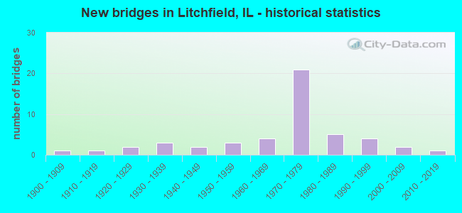
- New bridges - historical statistics
- 11900-1909
- 11910-1919
- 21920-1929
- 31930-1939
- 21940-1949
- 31950-1959
- 41960-1969
- 211970-1979
- 51980-1989
- 41990-1999
- 22000-2009
- 12010-2019
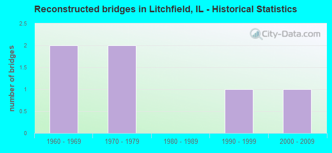
- Reconstructed bridges - Historical Statistics
- 21960-1969
- 21970-1979
- 01980-1989
- 11990-1999
- 12000-2009
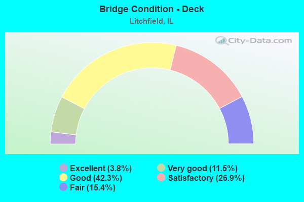
- Bridge Condition - Deck
- 3.8%Excellent
- 11.5%Very good
- 42.3%Good
- 26.9%Satisfactory
- 15.4%Fair
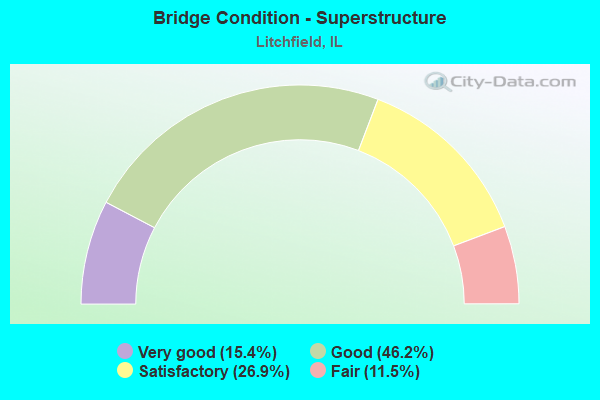
- Bridge Condition - Superstructure
- 15.4%Very good
- 46.2%Good
- 26.9%Satisfactory
- 11.5%Fair
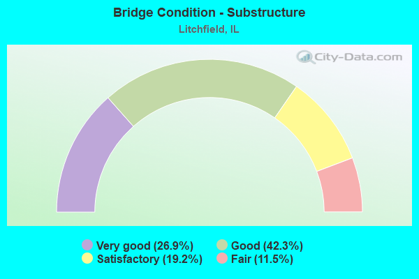
- Bridge Condition - Substructure
- 26.9%Very good
- 42.3%Good
- 19.2%Satisfactory
- 11.5%Fair
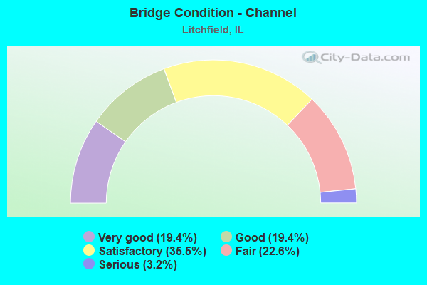
- Bridge Condition - Channel
- 19.4%Very good
- 19.4%Good
- 35.5%Satisfactory
- 22.6%Fair
- 3.2%Serious
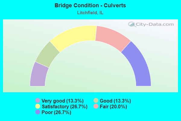
- Bridge Condition - Culverts
- 13.3%Very good
- 13.3%Good
- 26.7%Satisfactory
- 20.0%Fair
- 26.7%Poor
Find on map >> Show street view
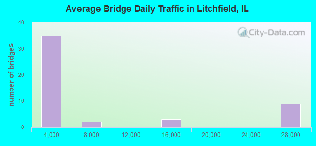
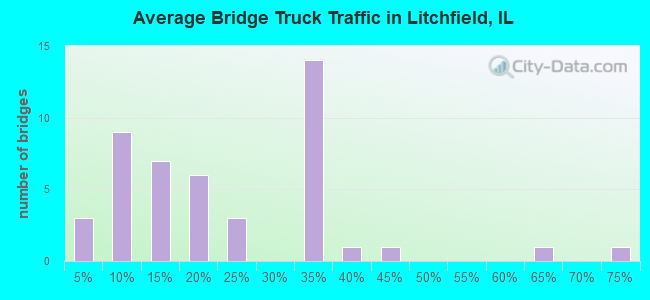
Structure Number: 680044, Location: 3M SO IL 108 (Lat: 39.233839, Lng: -89.641400), Route carried "under" structure: Interstate 55, Year Built: 1972, Structure Length: 0. m, Average Daily Traffic: 25,600 (year 2021), Truck Traffic: 32%, Features Intersected: I-55, Facility Carried by Structure: CH 24
Minimum Vertical Clearance: 5.33m (17.49ft), Kilometerpoint: 91.585, Lanes on structure: 2, Lanes under structure: 4, Material/Design: Steel continuous, Design/Construction: Stringer/Multi-beam, Length of Maximum Span: 33.8m (110.9ft)
Find on map >> Show street view
Structure Number: 680047, Location: 2.4M N IL 16 INT. (Lat: 39.204869, Lng: -89.659225), Route carried "under" structure: Interstate 55, Year Built: 1973, Structure Length: 0. m, Average Daily Traffic: 25,600 (year 2021), Truck Traffic: 32%, Features Intersected: I-55, Facility Carried by Structure: TR 48
Minimum Vertical Clearance: 5.03m (16.50ft), Kilometerpoint: 87.980, Lanes on structure: 2, Lanes under structure: 4, Material/Design: Steel continuous, Design/Construction: Stringer/Multi-beam, Length of Maximum Span: 36.9m (121.1ft)
Find on map >> Show street view
Structure Number: 68005, Location: 1.2M N IL 16 INT. (Lat: 39.190169, Lng: -89.670569), Route carried "under" structure: Interstate 55, Year Built: 1972, Structure Length: 0. m, Average Daily Traffic: 25,600 (year 2021), Truck Traffic: 32%, Features Intersected: I-55, Facility Carried by Structure: TR 235
Minimum Vertical Clearance: 4.95m (16.24ft), Kilometerpoint: 86.049, Lanes on structure: 2, Lanes under structure: 4, Material/Design: Steel continuous, Design/Construction: Stringer/Multi-beam, Length of Maximum Span: 32.9m (107.9ft)
Find on map >> Show street view
Structure Number: 680051, Location: LITCHFIELD INTERCHNG (Lat: 39.175300, Lng: -89.680869), Route carried "under" structure: Interstate 55, Year Built: 1973, Structure Length: 0. m, Average Daily Traffic: 25,600 (year 2021), Truck Traffic: 32%, Features Intersected: I-55, Facility Carried by Structure: IL 16
Minimum Vertical Clearance: 5.05m (16.57ft), Kilometerpoint: 84.215, Lanes on structure: 4, Lanes under structure: 6, Material/Design: Steel, Design/Construction: Stringer/Multi-beam, Length of Maximum Span: 33.7m (110.6ft)
Find on map >> Show street view
Structure Number: 680052, Location: 1.7M S IL 16 INT. (Lat: 39.153942, Lng: -89.695372), Route carried "under" structure: Interstate 55, Year Built: 1973, Structure Length: 0. m, Average Daily Traffic: 27,400 (year 2021), Truck Traffic: 33%, Features Intersected: I-55, Facility Carried by Structure: TR 277
Minimum Vertical Clearance: 4.98m (16.34ft), Kilometerpoint: 81.527, Lanes on structure: 2, Lanes under structure: 4, Material/Design: Steel continuous, Design/Construction: Stringer/Multi-beam, Length of Maximum Span: 32.9m (107.9ft)
Find on map >> Show street view
Structure Number: 6899, Location: 1.3M N 4-LANE OLD 66 (Lat: 39.214992, Lng: -89.650475), Route carried "under" structure: County highway , Year Built: 1950, Structure Length: 0. m, Average Daily Traffic: 1,950 (year 2020), Truck Traffic: 7%, Features Intersected: OLD US 66, Facility Carried by Structure: IC RR (ABANDONED)
Minimum Vertical Clearance: 4.42m (14.50ft), Kilometerpoint: 2.993, Lanes under structure: 4, Material/Design: Steel, Design/Construction: Girder and Floorbeam System, Length of Maximum Span: 21.9m (71.9ft)
Find on map >> Show street view
Structure Number: 689906, Location: .50MI SE HONEY BEND (Lat: 39.248297, Lng: -89.630006), Route carried "under" structure: County highway , Year Built: 1912, Structure Length: 0. m, Average Daily Traffic: 25 (year 2020), Features Intersected: TR 163A, Facility Carried by Structure: N&W RR
Minimum Vertical Clearance: 2.82m (9.25ft), Kilometerpoint: 0.966, Lanes under structure: 2, Material/Design: Steel, Design/Construction: Girder and Floorbeam System, Length of Maximum Span: 10.4m (34.1ft)