Bridge Statistics for Lockhart, Texas (TX)
Condition, Traffic, Stress, Structural Evaluation, Project Costs
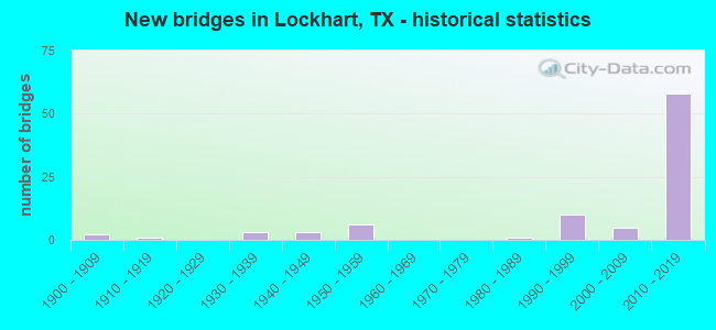
- New bridges - historical statistics
- 21900-1909
- 11910-1919
- 31930-1939
- 31940-1949
- 61950-1959
- 11980-1989
- 101990-1999
- 52000-2009
- 582010-2019
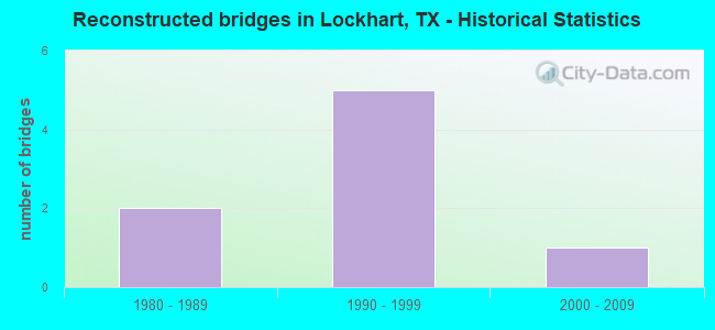
- Reconstructed bridges - Historical Statistics
- 21980-1989
- 51990-1999
- 12000-2009
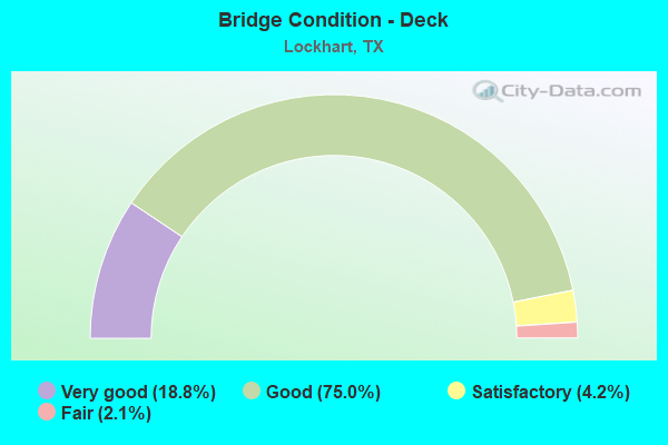
- Bridge Condition - Deck
- 18.8%Very good
- 75.0%Good
- 4.2%Satisfactory
- 2.1%Fair
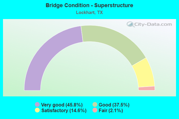
- Bridge Condition - Superstructure
- 45.8%Very good
- 37.5%Good
- 14.6%Satisfactory
- 2.1%Fair
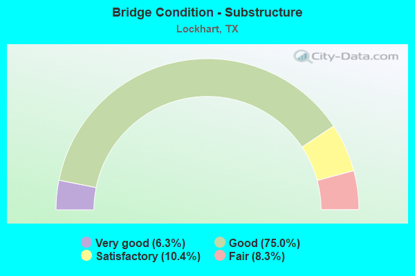
- Bridge Condition - Substructure
- 6.3%Very good
- 75.0%Good
- 10.4%Satisfactory
- 8.3%Fair
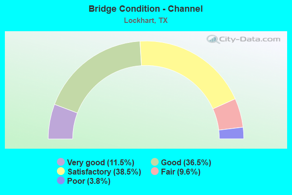
- Bridge Condition - Channel
- 11.5%Very good
- 36.5%Good
- 38.5%Satisfactory
- 9.6%Fair
- 3.8%Poor
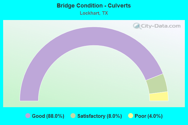
- Bridge Condition - Culverts
- 88.0%Good
- 8.0%Satisfactory
- 4.0%Poor
Find on map >> Show street view
Structure Number: 140280358301048, Location: 1.7 MI SW OF US 183 (Lat: 29.901242, Lng: -97.701781), Route carried "on" structure: Other road 130, Year Built: 2011, Status: Open, Structure Length: 9.85m (32.32ft), Average Daily Traffic: 17,619 (year 2010), Truck Traffic: 15%, Average Future Daily Traffic: 44,818 (year 2030), Design Load: HL 93, Features Intersected: FM 2001
Minimum Vertical Clearance: 30+ m (98+ ft), Kilometerpoint: 109.625, Lanes on structure: 2, Lanes under structure: 3, Toll: On toll road, Owner: State Highway Agency, Maintenance Responsibility: State Toll Authority, Approaching Roadway Width: 12.2m (40.0ft), Skew: 2 degrees, Material/Design: Prestressed concrete, Design/Construction: Stringer/Multi-beam, Number Of Spans In Main Unit: 3, Length of Maximum Span: 38.1m (125.0ft), Curb-To-Curb Width: 11.9m (39.0ft), Out-to-Out Width: 12.8m (42.0ft)
Condition: Deck: Good, Superstructure: Good, Substructure: Good, Operating Rating: 54.4 metric tons, Method Used To Determine Operating Rating: Assigned ratings based on Load and Resistance Factor Design (LRFD) reported in metric tons, Inventory Rating: 32.7 metric tons, Method Used To Determine Inventory Rating: Assigned ratings based on Load and Resistance Factor Design (LRFD) reported in metric tons, Structural Evaluation: Better than present minimum criteria, Deck Geometry: Better than present minimum criteria, Underclear: Superior to present desirable criteria, Approach Roadway Alignment: Equal to present desirable criteria, Designated Inspection Frequency: Every 24 months, Inspection Date: September 2021, Deck Structure Type: Concrete Precast Panels
Find on map >> Show street view
Structure Number: 140280358301049, Location: 1.4 MI S OF FM 2001 (Lat: 29.884019, Lng: -97.713181), Route carried "on" structure: Other road 130, Year Built: 2011, Status: Open, Structure Length: 8.41m (27.59ft), Average Daily Traffic: 17,417 (year 2010), Truck Traffic: 15%, Average Future Daily Traffic: 44,232 (year 2030), Design Load: HL 93, Features Intersected: SH 142
Minimum Vertical Clearance: 30+ m (98+ ft), Kilometerpoint: 111.877, Lanes on structure: 2, Lanes under structure: 2, Toll: On toll road, Owner: State Highway Agency, Maintenance Responsibility: State Toll Authority, Approaching Roadway Width: 13.7m (44.9ft), Material/Design: Prestressed concrete, Design/Construction: Stringer/Multi-beam, Number Of Spans In Main Unit: 2, Number Of Approach Spans: 1, Length of Maximum Span: 34.4m (112.9ft), Curb-To-Curb Width: 13.5m (44.3ft), Out-to-Out Width: 14.3m (46.9ft)
Condition: Deck: Good, Superstructure: Very good, Substructure: Good, Operating Rating: 54.4 metric tons, Method Used To Determine Operating Rating: Assigned ratings based on Load and Resistance Factor Design (LRFD) reported in metric tons, Inventory Rating: 32.7 metric tons, Method Used To Determine Inventory Rating: Assigned ratings based on Load and Resistance Factor Design (LRFD) reported in metric tons, Structural Evaluation: Better than present minimum criteria, Deck Geometry: Superior to present desirable criteria, Underclear: Superior to present desirable criteria, Approach Roadway Alignment: Equal to present desirable criteria, Designated Inspection Frequency: Every 24 months, Inspection Date: September 2021, Deck Structure Type: Concrete Precast Panels
Find on map >> Show street view
Structure Number: 14028035830105, Location: 1.4 MI S OF FM 2001 (Lat: 29.884769, Lng: -97.713950), Route carried "on" structure: Other road 130, Year Built: 2011, Status: Open, Structure Length: 8.41m (27.59ft), Average Daily Traffic: 17,502 (year 2010), Truck Traffic: 15%, Average Future Daily Traffic: 44,502 (year 2030), Design Load: HL 93, Features Intersected: SH 142
Minimum Vertical Clearance: 30+ m (98+ ft), Kilometerpoint: 111.877, Lanes on structure: 2, Lanes under structure: 2, Toll: On toll road, Owner: State Highway Agency, Maintenance Responsibility: State Toll Authority, Approaching Roadway Width: 14.6m (47.9ft), Material/Design: Prestressed concrete, Design/Construction: Stringer/Multi-beam, Number Of Spans In Main Unit: 2, Number Of Approach Spans: 1, Length of Maximum Span: 34.4m (112.9ft), Curb-To-Curb Width: 14.4m (47.2ft), Out-to-Out Width: 15.2m (49.9ft)
Condition: Deck: Very good, Superstructure: Good, Substructure: Good, Operating Rating: 54.4 metric tons, Method Used To Determine Operating Rating: Assigned ratings based on Load and Resistance Factor Design (LRFD) reported in metric tons, Inventory Rating: 32.7 metric tons, Method Used To Determine Inventory Rating: Assigned ratings based on Load and Resistance Factor Design (LRFD) reported in metric tons, Structural Evaluation: Better than present minimum criteria, Deck Geometry: Superior to present desirable criteria, Underclear: Superior to present desirable criteria, Approach Roadway Alignment: Equal to present desirable criteria, Designated Inspection Frequency: Every 24 months, Inspection Date: September 2021, Deck Structure Type: Concrete Precast Panels
Find on map >> Show street view
Structure Number: 140280358301051, Location: 1.60 MI S OF SH 142 (Lat: 29.868358, Lng: -97.707275), Route carried "on" structure: County highway 218, Year Built: 2012, Status: Open, Structure Length: 12.44m (40.81ft), Average Daily Traffic: 1,084 (year 2010), Average Future Daily Traffic: 2,958 (year 2030), Design Load: HL 93, Features Intersected: SH 130 ML
Minimum Vertical Clearance: 30+ m (98+ ft), Kilometerpoint: 0.885, Lanes on structure: 2, Lanes under structure: 4, Owner: State Highway Agency, Maintenance Responsibility: State Toll Authority, Approaching Roadway Width: 6.1m (20.0ft), Skew: 2 degrees, Material/Design: Prestressed concrete, Design/Construction: Stringer/Multi-beam, Number Of Spans In Main Unit: 2, Number Of Approach Spans: 3, Length of Maximum Span: 34.7m (113.8ft), Curb or Sidewalk Widths: Left: 1.8m (5.9ft), Right: 1.8m (5.9ft), Curb-To-Curb Width: 24.1m (79.1ft), Out-to-Out Width: 28.3m (92.8ft)
Condition: Deck: Good, Superstructure: Very good, Substructure: Good, Operating Rating: 54.4 metric tons, Method Used To Determine Operating Rating: Assigned ratings based on Load and Resistance Factor Design (LRFD) reported in metric tons, Inventory Rating: 32.7 metric tons, Method Used To Determine Inventory Rating: Assigned ratings based on Load and Resistance Factor Design (LRFD) reported in metric tons, Structural Evaluation: Better than present minimum criteria, Deck Geometry: Superior to present desirable criteria, Underclear: Superior to present desirable criteria, Approach Roadway Alignment: Equal to present desirable criteria, Designated Inspection Frequency: Every 24 months, Inspection Date: September 2021, Deck Structure Type: Concrete Precast Panels
Find on map >> Show street view
Structure Number: 140280358301053, Location: 5.75 MI S of SH 142 (Lat: 29.836847, Lng: -97.733231), Route carried "on" structure: County highway 109, Year Built: 2012, Status: Open, Structure Length: 11.52m (37.80ft), Average Daily Traffic: 223 (year 2010), Average Future Daily Traffic: 606 (year 2030), Design Load: HL 93, Features Intersected: SH 130
Minimum Vertical Clearance: 30+ m (98+ ft), Kilometerpoint: 0.000, Lanes on structure: 2, Lanes under structure: 4, Owner: State Highway Agency, Approaching Roadway Width: 6.1m (20.0ft), Material/Design: Prestressed concrete, Design/Construction: Stringer/Multi-beam, Number Of Spans In Main Unit: 2, Number Of Approach Spans: 2, Length of Maximum Span: 39.6m (129.9ft), Curb-To-Curb Width: 9.5m (31.2ft), Out-to-Out Width: 10.4m (34.1ft)
Condition: Deck: Very good, Superstructure: Very good, Substructure: Good, Operating Rating: 54.4 metric tons, Method Used To Determine Operating Rating: Assigned ratings based on Load and Resistance Factor Design (LRFD) reported in metric tons, Inventory Rating: 32.7 metric tons, Method Used To Determine Inventory Rating: Assigned ratings based on Load and Resistance Factor Design (LRFD) reported in metric tons, Structural Evaluation: Better than present minimum criteria, Deck Geometry: Equal to present minimum criteria, Underclear: Superior to present desirable criteria, Approach Roadway Alignment: Equal to present desirable criteria, Designated Inspection Frequency: Every 24 months, Inspection Date: September 2021, Deck Structure Type: Concrete Precast Panels
Find on map >> Show street view
Structure Number: 140280358301054, Location: 0.7 MI S OF SH 142 (Lat: 29.878842, Lng: -97.712550), Route carried "on" structure: County highway 108, Year Built: 2012, Status: Open, Structure Length: 19.81m (64.99ft), Average Daily Traffic: 547 (year 2010), Average Future Daily Traffic: 1,474 (year 2030), Design Load: HL 93, Features Intersected: SH 130
Minimum Vertical Clearance: 30+ m (98+ ft), Kilometerpoint: 1.127, Lanes on structure: 2, Lanes under structure: 8, Owner: State Highway Agency, Maintenance Responsibility: State Toll Authority, Approaching Roadway Width: 9.8m (32.2ft), Material/Design: Prestressed concrete, Design/Construction: Stringer/Multi-beam, Number Of Spans In Main Unit: 4, Number Of Approach Spans: 2, Length of Maximum Span: 39.6m (129.9ft), Curb-To-Curb Width: 9.8m (32.2ft), Out-to-Out Width: 10.4m (34.1ft)
Condition: Deck: Very good, Superstructure: Good, Substructure: Very good, Operating Rating: 54.4 metric tons, Method Used To Determine Operating Rating: Assigned ratings based on Load and Resistance Factor Design (LRFD) reported in metric tons, Inventory Rating: 32.7 metric tons, Method Used To Determine Inventory Rating: Assigned ratings based on Load and Resistance Factor Design (LRFD) reported in metric tons, Structural Evaluation: Better than present minimum criteria, Deck Geometry: Equal to present minimum criteria, Underclear: Superior to present desirable criteria, Approach Roadway Alignment: Equal to present desirable criteria, Designated Inspection Frequency: Every 24 months, Inspection Date: September 2021, Deck Structure Type: Concrete Precast Panels
Find on map >> Show street view
Structure Number: 140280358301057, Location: 0.4 MI SW OF FM 2001 (Lat: 29.895244, Lng: -97.711039), Route carried "on" structure: ServiceState highway 130, Year Built: 2011, Status: Open, Structure Length: 1.55m (5.09ft), Average Daily Traffic: 210 (year 2013), Truck Traffic: 18%, Average Future Daily Traffic: 290 (year 2033), Design Load: HS 20, Features Intersected: DRAINAGE DITCH
Minimum Vertical Clearance: 30+ m (98+ ft), Kilometerpoint: 110.641, Lanes on structure: 2, Owner: State Highway Agency, Maintenance Responsibility: State Toll Authority, Approaching Roadway Width: 11.0m (36.1ft), Skew: 1 degrees, Material/Design: Concrete, Design/Construction: Culvert, Number Of Spans In Main Unit: 5, Length of Maximum Span: 2.4m (7.9ft)
Condition: Channel: Good, Culverts: Good, Operating Rating: 54.4 metric tons, Method Used To Determine Operating Rating: Assigned rating based on Load Factor Design (LFD) reported in metric tons, Inventory Rating: 32.7 metric tons, Method Used To Determine Inventory Rating: Assigned rating based on Load Factor Design (LFD) reported in metric tons, Structural Evaluation: Better than present minimum criteria, Waterway Adequacy: Superior to present desirable criteria, Approach Roadway Alignment: Equal to present desirable criteria, Designated Inspection Frequency: Every 24 months, Inspection Date: September 2021
Find on map >> Show street view
Structure Number: 140280358301058, Location: 0.4 MI SW OF FM 2001 (Lat: 29.894817, Lng: -97.710653), Route carried "on" structure: Other road 130, Year Built: 2011, Status: Open, Structure Length: 1.55m (5.09ft), Average Daily Traffic: 17,502 (year 2010), Truck Traffic: 15%, Average Future Daily Traffic: 44,504 (year 2030), Design Load: HS 20, Features Intersected: DRAINAGE DITCH
Minimum Vertical Clearance: 30+ m (98+ ft), Kilometerpoint: 110.718, Lanes on structure: 2, Toll: On toll road, Owner: State Highway Agency, Maintenance Responsibility: State Toll Authority, Approaching Roadway Width: 12.2m (40.0ft), Skew: 1 degrees, Material/Design: Concrete, Design/Construction: Culvert, Number Of Spans In Main Unit: 5, Length of Maximum Span: 2.4m (7.9ft)
Condition: Channel: Good, Culverts: Good, Operating Rating: 54.4 metric tons, Method Used To Determine Operating Rating: Assigned rating based on Load Factor Design (LFD) reported in metric tons, Inventory Rating: 32.7 metric tons, Method Used To Determine Inventory Rating: Assigned rating based on Load Factor Design (LFD) reported in metric tons, Structural Evaluation: Better than present minimum criteria, Waterway Adequacy: Superior to present desirable criteria, Approach Roadway Alignment: Equal to present desirable criteria, Designated Inspection Frequency: Every 24 months, Inspection Date: September 2021
Find on map >> Show street view
Structure Number: 140280358301059, Location: 0.4 MI SW OF FM 2001 (Lat: 29.894147, Lng: -97.710242), Route carried "on" structure: Other road 130, Year Built: 2011, Status: Open, Structure Length: 1.55m (5.09ft), Average Daily Traffic: 17,417 (year 2010), Truck Traffic: 15%, Average Future Daily Traffic: 44,232 (year 2030), Design Load: HS 20, Features Intersected: DRAINAGE DITCH
Minimum Vertical Clearance: 30+ m (98+ ft), Kilometerpoint: 110.733, Lanes on structure: 2, Toll: On toll road, Owner: State Highway Agency, Maintenance Responsibility: State Toll Authority, Approaching Roadway Width: 12.2m (40.0ft), Skew: 1 degrees, Material/Design: Concrete, Design/Construction: Culvert, Number Of Spans In Main Unit: 5, Length of Maximum Span: 2.4m (7.9ft)
Condition: Channel: Good, Culverts: Good, Operating Rating: 54.4 metric tons, Method Used To Determine Operating Rating: Assigned rating based on Load Factor Design (LFD) reported in metric tons, Inventory Rating: 32.7 metric tons, Method Used To Determine Inventory Rating: Assigned rating based on Load Factor Design (LFD) reported in metric tons, Structural Evaluation: Better than present minimum criteria, Waterway Adequacy: Superior to present desirable criteria, Approach Roadway Alignment: Equal to present desirable criteria, Designated Inspection Frequency: Every 24 months, Inspection Date: September 2021
Find on map >> Show street view
Structure Number: 14028035830106, Location: 0.4 MI SW OF FM 2001 (Lat: 29.893717, Lng: -97.709847), Route carried "on" structure: ServiceState highway 130, Year Built: 2011, Status: Open, Structure Length: 1.55m (5.09ft), Average Daily Traffic: 180 (year 2013), Truck Traffic: 18%, Average Future Daily Traffic: 250 (year 2033), Design Load: HS 20, Features Intersected: DRAINAGE DITCH
Minimum Vertical Clearance: 30+ m (98+ ft), Kilometerpoint: 110.818, Lanes on structure: 3, Owner: State Highway Agency, Maintenance Responsibility: State Toll Authority, Approaching Roadway Width: 11.0m (36.1ft), Skew: 1 degrees, Material/Design: Concrete, Design/Construction: Culvert, Number Of Spans In Main Unit: 5, Length of Maximum Span: 2.4m (7.9ft)
Condition: Channel: Good, Culverts: Good, Operating Rating: 54.4 metric tons, Method Used To Determine Operating Rating: Assigned rating based on Load Factor Design (LFD) reported in metric tons, Inventory Rating: 32.7 metric tons, Method Used To Determine Inventory Rating: Assigned rating based on Load Factor Design (LFD) reported in metric tons, Structural Evaluation: Better than present minimum criteria, Waterway Adequacy: Superior to present desirable criteria, Approach Roadway Alignment: Equal to present desirable criteria, Designated Inspection Frequency: Every 24 months, Inspection Date: September 2021
Find on map >> Show street view
Structure Number: 140280358301061, Location: 3.4 MI S OF SH 142 (Lat: 29.841694, Lng: -97.729361), Route carried "on" structure: Other road 130, Year Built: 2011, Status: Open, Structure Length: 1.10m (3.61ft), Average Daily Traffic: 17,502 (year 2010), Truck Traffic: 15%, Average Future Daily Traffic: 44,504 (year 2030), Design Load: HS 20, Features Intersected: DRAINAGE DITCH
Minimum Vertical Clearance: 30+ m (98+ ft), Kilometerpoint: 117.706, Lanes on structure: 2, Toll: On toll road, Owner: State Highway Agency, Maintenance Responsibility: State Toll Authority, Approaching Roadway Width: 12.2m (40.0ft), Skew: 3 degrees, Material/Design: Concrete, Design/Construction: Culvert, Number Of Spans In Main Unit: 4, Length of Maximum Span: 1.8m (5.9ft)
Condition: Channel: Good, Culverts: Good, Operating Rating: 54.4 metric tons, Method Used To Determine Operating Rating: Assigned rating based on Load Factor Design (LFD) reported in metric tons, Inventory Rating: 32.7 metric tons, Method Used To Determine Inventory Rating: Assigned rating based on Load Factor Design (LFD) reported in metric tons, Structural Evaluation: Better than present minimum criteria, Waterway Adequacy: Superior to present desirable criteria, Approach Roadway Alignment: Equal to present desirable criteria, Designated Inspection Frequency: Every 24 months, Inspection Date: September 2021
Find on map >> Show street view
Structure Number: 140280358301062, Location: 3.4 MI S OF SH 142 (Lat: 29.840989, Lng: -97.728850), Route carried "on" structure: Other road 130, Year Built: 2011, Status: Open, Structure Length: 1.10m (3.61ft), Average Daily Traffic: 17,417 (year 2010), Truck Traffic: 15%, Average Future Daily Traffic: 44,232 (year 2030), Design Load: HS 20, Features Intersected: DRAINAGE DITCH
Minimum Vertical Clearance: 30+ m (98+ ft), Kilometerpoint: 117.680, Lanes on structure: 2, Toll: On toll road, Owner: State Highway Agency, Maintenance Responsibility: State Toll Authority, Approaching Roadway Width: 12.2m (40.0ft), Skew: 3 degrees, Material/Design: Concrete, Design/Construction: Culvert, Number Of Spans In Main Unit: 4, Length of Maximum Span: 1.8m (5.9ft)
Condition: Channel: Good, Culverts: Good, Operating Rating: 54.4 metric tons, Method Used To Determine Operating Rating: Assigned rating based on Load Factor Design (LFD) reported in metric tons, Inventory Rating: 32.7 metric tons, Method Used To Determine Inventory Rating: Assigned rating based on Load Factor Design (LFD) reported in metric tons, Structural Evaluation: Better than present minimum criteria, Waterway Adequacy: Superior to present desirable criteria, Approach Roadway Alignment: Equal to present desirable criteria, Designated Inspection Frequency: Every 24 months, Inspection Date: September 2021
Find on map >> Show street view
Structure Number: 140280358301063, Location: 4.5 MI NE OF SH 80 (Lat: 29.834561, Lng: -97.736942), Route carried "on" structure: ServiceState highway 130, Year Built: 2011, Status: Open, Structure Length: 2.38m (7.81ft), Average Daily Traffic: 210 (year 2013), Average Future Daily Traffic: 290 (year 2033), Design Load: HS 20, Features Intersected: BIG WEST FORK
Minimum Vertical Clearance: 30+ m (98+ ft), Kilometerpoint: 118.797, Lanes on structure: 2, Owner: State Highway Agency, Maintenance Responsibility: State Toll Authority, Approaching Roadway Width: 8.5m (27.9ft), Skew: 3 degrees, Material/Design: Concrete, Design/Construction: Culvert, Number Of Spans In Main Unit: 6, Length of Maximum Span: 2.7m (8.9ft)
Condition: Channel: Good, Culverts: Good, Operating Rating: 54.4 metric tons, Method Used To Determine Operating Rating: Assigned rating based on Load Factor Design (LFD) reported in metric tons, Inventory Rating: 32.7 metric tons, Method Used To Determine Inventory Rating: Assigned rating based on Load Factor Design (LFD) reported in metric tons, Structural Evaluation: Better than present minimum criteria, Waterway Adequacy: Superior to present desirable criteria, Approach Roadway Alignment: Equal to present desirable criteria, Designated Inspection Frequency: Every 24 months, Inspection Date: September 2021
Find on map >> Show street view
Structure Number: 140280358301064, Location: 4.5 MI NE OF SH 80 (Lat: 29.833911, Lng: -97.736783), Route carried "on" structure: Other road 130, Year Built: 2011, Status: Open, Structure Length: 2.10m (6.89ft), Average Daily Traffic: 17,502 (year 2010), Truck Traffic: 15%, Average Future Daily Traffic: 44,504 (year 2030), Design Load: HS 20, Features Intersected: BIG WEST FORK
Minimum Vertical Clearance: 30+ m (98+ ft), Kilometerpoint: 118.831, Lanes on structure: 2, Toll: On toll road, Owner: State Highway Agency, Maintenance Responsibility: State Toll Authority, Approaching Roadway Width: 12.2m (40.0ft), Skew: 1 degrees, Material/Design: Concrete, Design/Construction: Culvert, Number Of Spans In Main Unit: 6, Length of Maximum Span: 2.7m (8.9ft)
Condition: Channel: Very good, Culverts: Good, Operating Rating: 54.4 metric tons, Method Used To Determine Operating Rating: Assigned rating based on Load Factor Design (LFD) reported in metric tons, Inventory Rating: 32.7 metric tons, Method Used To Determine Inventory Rating: Assigned rating based on Load Factor Design (LFD) reported in metric tons, Structural Evaluation: Better than present minimum criteria, Waterway Adequacy: Superior to present desirable criteria, Approach Roadway Alignment: Equal to present desirable criteria, Designated Inspection Frequency: Every 24 months, Inspection Date: September 2021
Find on map >> Show street view
Structure Number: 140280358301065, Location: 4.5 MI NE OF SH 80 (Lat: 29.833131, Lng: -97.736553), Route carried "on" structure: Other road 130, Year Built: 2011, Status: Open, Structure Length: 2.10m (6.89ft), Average Daily Traffic: 17,417 (year 2010), Truck Traffic: 15%, Average Future Daily Traffic: 44,232 (year 2030), Design Load: HS 20, Features Intersected: BIG WEST FORK
Minimum Vertical Clearance: 30+ m (98+ ft), Kilometerpoint: 118.842, Lanes on structure: 2, Toll: On toll road, Owner: State Highway Agency, Maintenance Responsibility: State Toll Authority, Approaching Roadway Width: 12.2m (40.0ft), Skew: 1 degrees, Material/Design: Concrete, Design/Construction: Culvert, Number Of Spans In Main Unit: 6, Length of Maximum Span: 2.7m (8.9ft)
Condition: Channel: Very good, Culverts: Good, Operating Rating: 54.4 metric tons, Method Used To Determine Operating Rating: Assigned rating based on Load Factor Design (LFD) reported in metric tons, Inventory Rating: 32.7 metric tons, Method Used To Determine Inventory Rating: Assigned rating based on Load Factor Design (LFD) reported in metric tons, Structural Evaluation: Better than present minimum criteria, Waterway Adequacy: Superior to present desirable criteria, Approach Roadway Alignment: Equal to present desirable criteria, Designated Inspection Frequency: Every 24 months, Inspection Date: September 2021
Find on map >> Show street view
Structure Number: 140280358301066, Location: 4.25 MI NE OF SH 80 (Lat: 29.829267, Lng: -97.743919), Route carried "on" structure: ServiceState highway 130, Year Built: 2011, Status: Open, Structure Length: 2.29m (7.51ft), Average Daily Traffic: 210 (year 2013), Average Future Daily Traffic: 290 (year 2033), Design Load: HS 20, Features Intersected: LITTLE WEST FORK
Minimum Vertical Clearance: 30+ m (98+ ft), Kilometerpoint: 119.685, Lanes on structure: 2, Owner: State Highway Agency, Maintenance Responsibility: State Toll Authority, Approaching Roadway Width: 8.5m (27.9ft), Skew: 1 degrees, Material/Design: Concrete, Design/Construction: Culvert, Number Of Spans In Main Unit: 6, Length of Maximum Span: 3.0m (9.8ft)
Condition: Channel: Good, Culverts: Good, Operating Rating: 54.4 metric tons, Method Used To Determine Operating Rating: Assigned rating based on Load Factor Design (LFD) reported in metric tons, Inventory Rating: 32.7 metric tons, Method Used To Determine Inventory Rating: Assigned rating based on Load Factor Design (LFD) reported in metric tons, Structural Evaluation: Better than present minimum criteria, Waterway Adequacy: Superior to present desirable criteria, Approach Roadway Alignment: Equal to present desirable criteria, Designated Inspection Frequency: Every 24 months, Inspection Date: September 2021
Find on map >> Show street view
Structure Number: 140280358301067, Location: 4.25 MI NE OF SH 80 (Lat: 29.828742, Lng: -97.743597), Route carried "on" structure: Other road 130, Year Built: 2011, Status: Open, Structure Length: 2.29m (7.51ft), Average Daily Traffic: 34,919 (year 2010), Truck Traffic: 15%, Average Future Daily Traffic: 88,736 (year 2030), Design Load: HS 20, Features Intersected: LITTLE WEST FORK
Minimum Vertical Clearance: 30+ m (98+ ft), Kilometerpoint: 119.701, Lanes on structure: 4, Toll: On toll road, Owner: State Highway Agency, Maintenance Responsibility: State Toll Authority, Approaching Roadway Width: 24.4m (80.1ft), Skew: 11 degrees, Material/Design: Concrete, Design/Construction: Culvert, Number Of Spans In Main Unit: 6, Length of Maximum Span: 3.0m (9.8ft)
Condition: Channel: Very good, Culverts: Good, Operating Rating: 54.4 metric tons, Method Used To Determine Operating Rating: Assigned rating based on Load Factor Design (LFD) reported in metric tons, Inventory Rating: 32.7 metric tons, Method Used To Determine Inventory Rating: Assigned rating based on Load Factor Design (LFD) reported in metric tons, Structural Evaluation: Better than present minimum criteria, Waterway Adequacy: Superior to present desirable criteria, Approach Roadway Alignment: Equal to present desirable criteria, Designated Inspection Frequency: Every 24 months, Inspection Date: September 2021
Find on map >> Show street view
Structure Number: 140280358301068, Location: 4.25 MI NE OF SH 80 (Lat: 29.827250, Lng: -97.743014), Route carried "on" structure: ServiceState highway 130, Year Built: 2011, Status: Open, Structure Length: 2.32m (7.61ft), Average Daily Traffic: 4,347 (year 2010), Truck Traffic: 15%, Average Future Daily Traffic: 11,821 (year 2030), Design Load: HS 20, Features Intersected: LITTLE WEST FORK
Minimum Vertical Clearance: 30+ m (98+ ft), Kilometerpoint: 119.738, Lanes on structure: 2, Owner: State Highway Agency, Maintenance Responsibility: State Toll Authority, Approaching Roadway Width: 8.5m (27.9ft), Skew: 1 degrees, Material/Design: Concrete, Design/Construction: Culvert, Number Of Spans In Main Unit: 6, Length of Maximum Span: 3.0m (9.8ft)
Condition: Channel: Very good, Culverts: Good, Operating Rating: 54.4 metric tons, Method Used To Determine Operating Rating: Assigned rating based on Load Factor Design (LFD) reported in metric tons, Inventory Rating: 32.7 metric tons, Method Used To Determine Inventory Rating: Assigned rating based on Load Factor Design (LFD) reported in metric tons, Structural Evaluation: Better than present minimum criteria, Waterway Adequacy: Superior to present desirable criteria, Approach Roadway Alignment: Equal to present desirable criteria, Designated Inspection Frequency: Every 24 months, Inspection Date: September 2021
Find on map >> Show street view
Structure Number: 140280358301075, Location: 1.6 MI S OF SH 142 (Lat: 29.869103, Lng: -97.707206), Route carried "on" structure: Ramp State highway 130, Year Built: 2012, Status: Open, Structure Length: 10.03m (32.91ft), Average Daily Traffic: 100 (year 2010), Truck Traffic: 15%, Average Future Daily Traffic: 150 (year 2030), Design Load: HL 93, Features Intersected: SH 130 ML, Facility Carried by Structure: CR 218 N T/A
Minimum Vertical Clearance: 30+ m (98+ ft), Kilometerpoint: 113.744, Lanes on structure: 1, Lanes under structure: 4, Owner: State Highway Agency, Maintenance Responsibility: State Toll Authority, Approaching Roadway Width: 7.0m (23.0ft), Material/Design: Prestressed concrete, Design/Construction: Stringer/Multi-beam, Number Of Spans In Main Unit: 2, Number Of Approach Spans: 2, Length of Maximum Span: 34.7m (113.8ft), Curb-To-Curb Width: 7.0m (23.0ft), Out-to-Out Width: 7.6m (24.9ft)
Condition: Deck: Very good, Superstructure: Very good, Substructure: Good, Operating Rating: 54.4 metric tons, Method Used To Determine Operating Rating: Assigned ratings based on Load and Resistance Factor Design (LRFD) reported in metric tons, Inventory Rating: 32.7 metric tons, Method Used To Determine Inventory Rating: Assigned ratings based on Load and Resistance Factor Design (LRFD) reported in metric tons, Structural Evaluation: Better than present minimum criteria, Deck Geometry: Equal to present minimum criteria, Underclear: Superior to present desirable criteria, Approach Roadway Alignment: Equal to present desirable criteria, Designated Inspection Frequency: Every 24 months, Inspection Date: September 2021, Deck Structure Type: Concrete Precast Panels
Find on map >> Show street view
Structure Number: 140280AA0108001, Location: 2.9 MI N OF SH 142 (Lat: 29.907628, Lng: -97.745242), Route carried "on" structure: County highway 230, Year Built: 2006, Status: Open, Structure Length: 1.07m (3.51ft), Average Daily Traffic: 60 (year 2010), Average Future Daily Traffic: 100 (year 2027), Design Load: HS 20, Features Intersected: BOGGY CREEK
Minimum Vertical Clearance: 30+ m (98+ ft), Kilometerpoint: 4.667, Lanes on structure: 2, Owner: County Highway Agency, Approaching Roadway Width: 5.5m (18.0ft), Material/Design: Steel, Design/Construction: Culvert, Number Of Spans In Main Unit: 5, Length of Maximum Span: 1.5m (4.9ft), Curb-To-Curb Width: 8.4m (27.6ft), Out-to-Out Width: 10.7m (35.1ft)
Condition: Channel: Satisfactory, Culverts: Good, Operating Rating: 54.4 metric tons, Method Used To Determine Operating Rating: Assigned rating based on Load Factor Design (LFD) reported in metric tons, Inventory Rating: 32.7 metric tons, Method Used To Determine Inventory Rating: Assigned rating based on Load Factor Design (LFD) reported in metric tons, Structural Evaluation: Better than present minimum criteria, Deck Geometry: Equal to present minimum criteria, Waterway Adequacy: Better than present minimum criteria, Approach Roadway Alignment: Equal to present desirable criteria, Designated Inspection Frequency: Every 24 months, Inspection Date: December 2021, Deck Structure Type: Corrugated Steel, Wearing Surface/Protective System: Wearing Surface: Gravel
Find on map >> Show street view
Structure Number: 140280AA0154001, Location: 1.00 MI SW OF FM 1185 (Lat: 29.948922, Lng: -97.658664), Route carried "on" structure: County highway 183, Year Built: 1934, Status: Open, Structure Length: 1.22m (4.00ft), Average Daily Traffic: 120 (year 2010), Average Future Daily Traffic: 130 (year 2027), Features Intersected: DRY CREEK, Facility Carried by Structure: OLD LYTTON SPRINGS
Minimum Vertical Clearance: 30+ m (98+ ft), Kilometerpoint: 1.609, Lanes on structure: 1, Owner: County Highway Agency, Approaching Roadway Width: 6.1m (20.0ft), Material/Design: Steel, Design/Construction: Stringer/Multi-beam, Number Of Spans In Main Unit: 2, Length of Maximum Span: 5.8m (19.0ft), Curb-To-Curb Width: 5.5m (18.0ft), Out-to-Out Width: 5.9m (19.4ft)
Condition: Deck: Satisfactory, Superstructure: Satisfactory, Substructure: Fair, Channel: Fair, Operating Rating: 32.7 metric tons, Method Used To Determine Operating Rating: Field evaluation and documented engineering judgment, Inventory Rating: 24.5 metric tons, Method Used To Determine Inventory Rating: Field evaluation and documented engineering judgment, Structural Evaluation: Somewhat better than minimum adequacy, Deck Geometry: High priority of corrective action, Waterway Adequacy: Meets minimum limits, Approach Roadway Alignment: Equal to present desirable criteria, Bridge Posting: Required (Relationship of Operating Rating to Maximum Legal Load: 20.0 - 29.9% below), Length Of Structure Improvement: 1.22m (4.00ft), Designated Inspection Frequency: Every 24 months, Inspection Date: December 2021, Bridge Improvement Cost: $1,000, Total Project Cost: $1,000, Deck Structure Type: Concrete Cast-file-Place, Wearing Surface/Protective System: Wearing Surface: Bituminous
Find on map >> Show street view
Structure Number: 140280AA0154002, Location: 1.30 MI SW OF FM 1185 (Lat: 29.945275, Lng: -97.661567), Route carried "on" structure: County highway 183, Year Built: 2005, Status: Open, Structure Length: 1.10m (3.61ft), Average Daily Traffic: 120 (year 2010), Average Future Daily Traffic: 130 (year 2027), Design Load: HS 20, Features Intersected: DRY CREEK BRANCH, Facility Carried by Structure: OLD LYTTON SPRINGS
Minimum Vertical Clearance: 30+ m (98+ ft), Kilometerpoint: 2.092, Lanes on structure: 2, Owner: County Highway Agency, Approaching Roadway Width: 6.1m (20.0ft), Material/Design: Concrete, Design/Construction: Culvert, Number Of Spans In Main Unit: 3, Length of Maximum Span: 3.0m (9.8ft), Curb-To-Curb Width: 7.2m (23.6ft), Out-to-Out Width: 7.9m (25.9ft)
Condition: Channel: Satisfactory, Culverts: Good, Operating Rating: 54.4 metric tons, Method Used To Determine Operating Rating: Assigned rating based on Load Factor Design (LFD) reported in metric tons, Inventory Rating: 32.7 metric tons, Method Used To Determine Inventory Rating: Assigned rating based on Load Factor Design (LFD) reported in metric tons, Structural Evaluation: Better than present minimum criteria, Deck Geometry: Meets minimum limits, Waterway Adequacy: Meets minimum limits, Approach Roadway Alignment: Equal to present desirable criteria, Designated Inspection Frequency: Every 24 months, Inspection Date: December 2021, Deck Structure Type: Concrete Cast-file-Place, Wearing Surface/Protective System: Wearing Surface: Bituminous
Find on map >> Show street view
Structure Number: 140280AA0155001, Location: 1.35 MI N OF FM 672 (Lat: 29.919436, Lng: -97.653825), Route carried "on" structure: County highway 182, Year Built: 1900, Status: Open, Structure Length: 1.13m (3.71ft), Average Daily Traffic: 90 (year 2010), Average Future Daily Traffic: 120 (year 2027), Features Intersected: DRY CREEK
Minimum Vertical Clearance: 30+ m (98+ ft), Kilometerpoint: 5.311, Lanes on structure: 1, Owner: County Highway Agency, Approaching Roadway Width: 4.9m (16.1ft), Material/Design: Concrete, Design/Construction: Arch - Deck, Number Of Spans In Main Unit: 1, Length of Maximum Span: 10.4m (34.1ft), Curb-To-Curb Width: 3.9m (12.8ft), Out-to-Out Width: 4.3m (14.1ft)
Condition: Deck: Very good, Superstructure: Satisfactory, Substructure: Fair, Channel: Satisfactory, Operating Rating: 32.7 metric tons, Method Used To Determine Operating Rating: Field evaluation and documented engineering judgment, Inventory Rating: 24.5 metric tons, Method Used To Determine Inventory Rating: Field evaluation and documented engineering judgment, Structural Evaluation: Somewhat better than minimum adequacy, Deck Geometry: Meets minimum limits, Waterway Adequacy: Better than present minimum criteria, Approach Roadway Alignment: Somewhat better than minimum adequacy, Length Of Structure Improvement: 1.04m (3.41ft), Designated Inspection Frequency: Every 24 months, Inspection Date: December 2021, Total Project Cost: $122,000, Deck Structure Type: Concrete Cast-file-Place, Wearing Surface/Protective System: Wearing Surface: Gravel
Find on map >> Show street view
Structure Number: 140280AA0173002, Location: 0.70 MI EAST OF SHADY LN (Lat: 29.881789, Lng: -97.630600), Route carried "on" structure: County highway 186, Year Built: 1999, Status: Open, Structure Length: 5.00m (16.40ft), Average Daily Traffic: 85 (year 2010), Truck Traffic: 2%, Average Future Daily Traffic: 120 (year 2027), Design Load: HS 20, Features Intersected: PLUM CREEK
Minimum Vertical Clearance: 30+ m (98+ ft), Kilometerpoint: 4.345, Lanes on structure: 2, Owner: County Highway Agency, Approaching Roadway Width: 5.5m (18.0ft), Skew: 1 degrees, Material/Design: Prestressed concrete, Design/Construction: Stringer/Multi-beam, Number Of Spans In Main Unit: 3, Length of Maximum Span: 21.9m (71.9ft), Curb-To-Curb Width: 7.1m (23.3ft), Out-to-Out Width: 7.8m (25.6ft)
Condition: Deck: Good, Superstructure: Very good, Substructure: Satisfactory, Channel: Fair, Operating Rating: 54.4 metric tons, Method Used To Determine Operating Rating: Assigned rating based on Load Factor Design (LFD) reported in metric tons, Inventory Rating: 32.7 metric tons, Method Used To Determine Inventory Rating: Assigned rating based on Load Factor Design (LFD) reported in metric tons, Structural Evaluation: Equal to present minimum criteria, Deck Geometry: Somewhat better than minimum adequacy, Waterway Adequacy: Better than present minimum criteria, Approach Roadway Alignment: Equal to present minimum criteria, Designated Inspection Frequency: Every 24 months, Inspection Date: December 2021, Deck Structure Type: Concrete Precast Panels, Wearing Surface/Protective System: Wearing Surface: Bituminous
Find on map >> Show street view
Structure Number: 140280AA0226001, Location: 1.05 MI SW OF FM 1322 (Lat: 29.798081, Lng: -97.643564), Route carried "on" structure: County highway 207, Year Built: 1992, Status: Open, Structure Length: 1.49m (4.89ft), Average Daily Traffic: 64 (year 2011), Average Future Daily Traffic: 95 (year 2031), Design Load: HS 20, Features Intersected: BRUSHY BRANCH
Minimum Vertical Clearance: 30+ m (98+ ft), Kilometerpoint: 1.770, Lanes on structure: 2, Owner: County Highway Agency, Approaching Roadway Width: 5.5m (18.0ft), Material/Design: Concrete, Design/Construction: Culvert, Number Of Spans In Main Unit: 4, Length of Maximum Span: 3.0m (9.8ft), Curb-To-Curb Width: 7.5m (24.6ft), Out-to-Out Width: 10.7m (35.1ft)
Condition: Channel: Satisfactory, Culverts: Satisfactory, Operating Rating: 39.9 metric tons, Method Used To Determine Operating Rating: Load Factor (LF), Inventory Rating: 23.6 metric tons, Method Used To Determine Inventory Rating: Load Factor (LF), Structural Evaluation: Equal to present minimum criteria, Deck Geometry: Equal to present minimum criteria, Waterway Adequacy: Better than present minimum criteria, Approach Roadway Alignment: Equal to present desirable criteria, Designated Inspection Frequency: Every 24 months, Inspection Date: December 2021, Deck Structure Type: Concrete Cast-file-Place, Wearing Surface/Protective System: Wearing Surface: Bituminous
Find on map >> Show street view
Structure Number: 140280AA0226002, Location: 1.25 MI SW OF FM 1322 (Lat: 29.796600, Lng: -97.645661), Route carried "on" structure: County highway 207, Year Built: 1985, Status: Open, Structure Length: 2.90m (9.51ft), Average Daily Traffic: 100 (year 2015), Average Future Daily Traffic: 84 (year 2031), Design Load: HS 20, Features Intersected: CLEAR FORK PLUM CREEK, Facility Carried by Structure: BURDETTE WELLS RD
Minimum Vertical Clearance: 30+ m (98+ ft), Kilometerpoint: 2.012, Lanes on structure: 2, Owner: County Highway Agency, Approaching Roadway Width: 5.5m (18.0ft), Skew: 1 degrees, Material/Design: Prestressed concrete, Design/Construction: Stringer/Multi-beam, Number Of Spans In Main Unit: 1, Length of Maximum Span: 29.0m (95.1ft), Curb-To-Curb Width: 8.5m (27.9ft), Out-to-Out Width: 9.2m (30.2ft)
Condition: Deck: Good, Superstructure: Very good, Substructure: Good, Channel: Fair, Operating Rating: 54.4 metric tons, Method Used To Determine Operating Rating: Assigned rating based on Load Factor Design (LFD) reported in metric tons, Inventory Rating: 32.7 metric tons, Method Used To Determine Inventory Rating: Assigned rating based on Load Factor Design (LFD) reported in metric tons, Structural Evaluation: Better than present minimum criteria, Deck Geometry: Better than present minimum criteria, Waterway Adequacy: Equal to present minimum criteria, Approach Roadway Alignment: Somewhat better than minimum adequacy, Designated Inspection Frequency: Every 24 months, Inspection Date: December 2021, Deck Structure Type: Concrete Precast Panels, Wearing Surface/Protective System: Wearing Surface: Bituminous
Find on map >> Show street view
Structure Number: 140280AA0243001, Location: 0.50 MI NE OF US 183 (Lat: 29.826081, Lng: -97.667983), Route carried "on" structure: County highway 213, Year Built: 1918, Status: Open, Structure Length: 2.90m (9.51ft), Average Daily Traffic: 100 (year 2020), Average Future Daily Traffic: 100 (year 2027), Features Intersected: CLEAR FORK PLUM CREEK
Minimum Vertical Clearance: 30+ m (98+ ft), Kilometerpoint: 2.414, Lanes on structure: 1, Owner: County Highway Agency, Approaching Roadway Width: 4.3m (14.1ft), Material/Design: Concrete, Design/Construction: Slab, Number Of Spans In Main Unit: 8, Length of Maximum Span: 3.7m (12.1ft), Curb-To-Curb Width: 5.5m (18.0ft), Out-to-Out Width: 6.1m (20.0ft)
Condition: Deck: Satisfactory, Superstructure: Satisfactory, Substructure: Satisfactory, Channel: Fair, Operating Rating: 39.0 metric tons, Method Used To Determine Operating Rating: Load Factor (LF), Inventory Rating: 22.7 metric tons, Method Used To Determine Inventory Rating: Load Factor (LF), Structural Evaluation: Equal to present minimum criteria, Deck Geometry: Meets minimum limits, Waterway Adequacy: Meets minimum limits, Approach Roadway Alignment: Equal to present minimum criteria, Length Of Structure Improvement: 2.93m (9.61ft), Designated Inspection Frequency: Every 24 months, Inspection Date: December 2021, Total Project Cost: $161,000, Deck Structure Type: Concrete Cast-file-Place
Find on map >> Show street view
Structure Number: 140280AA0266003, Location: 2.55 MI SE OF FM 20 (Lat: 29.865161, Lng: -97.615375), Route carried "on" structure: County highway 202, Year Built: 1999, Status: Open, Structure Length: 4.21m (13.81ft), Average Daily Traffic: 100 (year 2015), Average Future Daily Traffic: 85 (year 2027), Design Load: HS 20, Features Intersected: PLUM CREEK, Facility Carried by Structure: OLD MCMAHAN RD
Minimum Vertical Clearance: 30+ m (98+ ft), Kilometerpoint: 4.104, Lanes on structure: 2, Owner: County Highway Agency, Approaching Roadway Width: 6.1m (20.0ft), Skew: 1 degrees, Material/Design: Prestressed concrete, Design/Construction: Stringer/Multi-beam, Number Of Spans In Main Unit: 3, Length of Maximum Span: 15.9m (52.2ft), Curb-To-Curb Width: 7.1m (23.3ft), Out-to-Out Width: 7.8m (25.6ft)
Condition: Deck: Very good, Superstructure: Good, Substructure: Good, Channel: Satisfactory, Operating Rating: 54.4 metric tons, Method Used To Determine Operating Rating: Assigned rating based on Load Factor Design (LFD) reported in metric tons, Inventory Rating: 32.7 metric tons, Method Used To Determine Inventory Rating: Assigned rating based on Load Factor Design (LFD) reported in metric tons, Structural Evaluation: Better than present minimum criteria, Deck Geometry: Somewhat better than minimum adequacy, Waterway Adequacy: Better than present minimum criteria, Approach Roadway Alignment: Better than present minimum criteria, Designated Inspection Frequency: Every 24 months, Inspection Date: December 2021, Deck Structure Type: Concrete Precast Panels, Wearing Surface/Protective System: Wearing Surface: Bituminous
Find on map >> Show street view
Structure Number: 140280AA0272502, Location: 2.00 MI SW OF SH 142 (Lat: 29.869364, Lng: -97.731108), Route carried "on" structure: County highway 108, Year Built: 2010, Status: Open, Structure Length: 1.52m (4.99ft), Average Daily Traffic: 168 (year 2010), Average Future Daily Traffic: 218 (year 2027), Design Load: HL 93, Features Intersected: CLEAR FORK PLUM CREEK
Minimum Vertical Clearance: 30+ m (98+ ft), Kilometerpoint: 3.219, Lanes on structure: 2, Owner: County Highway Agency, Approaching Roadway Width: 6.1m (20.0ft), Skew: 1 degrees, Material/Design: Prestressed concrete, Number Of Spans In Main Unit: 2, Length of Maximum Span: 7.6m (24.9ft), Curb-To-Curb Width: 8.5m (27.9ft), Out-to-Out Width: 9.2m (30.2ft)
Condition: Deck: Good, Superstructure: Very good, Substructure: Good, Channel: Satisfactory, Operating Rating: 54.4 metric tons, Method Used To Determine Operating Rating: Assigned ratings based on Load and Resistance Factor Design (LRFD) reported in metric tons, Inventory Rating: 32.7 metric tons, Method Used To Determine Inventory Rating: Assigned ratings based on Load and Resistance Factor Design (LRFD) reported in metric tons, Structural Evaluation: Better than present minimum criteria, Deck Geometry: Equal to present minimum criteria, Waterway Adequacy: Meets minimum limits, Approach Roadway Alignment: Equal to present desirable criteria, Designated Inspection Frequency: Every 24 months, Inspection Date: December 2021, Deck Structure Type: Concrete Cast-file-Place
Find on map >> Show street view
Structure Number: 140280AA0345002, Location: 0.60 MI SW OF US 183 (Lat: 29.835644, Lng: -97.678492), Route carried "on" structure: County highway 213, Year Built: 1997, Status: Open, Structure Length: 3.05m (10.01ft), Average Daily Traffic: 438 (year 2020), Average Future Daily Traffic: 675 (year 2027), Design Load: HS 20, Features Intersected: CLEAR FORK PLUM CREEK
Minimum Vertical Clearance: 30+ m (98+ ft), Kilometerpoint: 0.966, Lanes on structure: 2, Owner: County Highway Agency, Approaching Roadway Width: 5.5m (18.0ft), Material/Design: Prestressed concrete, Design/Construction: Stringer/Multi-beam, Number Of Spans In Main Unit: 1, Number Of Approach Spans: 2, Length of Maximum Span: 15.2m (49.9ft), Curb-To-Curb Width: 7.2m (23.6ft), Out-to-Out Width: 7.9m (25.9ft)
Condition: Deck: Good, Superstructure: Very good, Substructure: Good, Channel: Satisfactory, Operating Rating: 54.4 metric tons, Method Used To Determine Operating Rating: Assigned rating based on Load Factor Design (LFD) reported in metric tons, Inventory Rating: 32.7 metric tons, Method Used To Determine Inventory Rating: Assigned rating based on Load Factor Design (LFD) reported in metric tons, Structural Evaluation: Better than present minimum criteria, Deck Geometry: Meets minimum limits, Waterway Adequacy: Meets minimum limits, Approach Roadway Alignment: Equal to present desirable criteria, Designated Inspection Frequency: Every 24 months, Inspection Date: December 2021, Deck Structure Type: Concrete Precast Panels, Wearing Surface/Protective System: Wearing Surface: Bituminous
Find on map >> Show street view
Structure Number: 140280B00050001, Location: 0.5 MI S OF FM 2001 (Lat: 29.890800, Lng: -97.675833), Route carried "on" structure: City street 417, Year Built: 1942, Status: Open, Structure Length: 1.37m (4.49ft), Average Daily Traffic: 266 (year 2011), Average Future Daily Traffic: 380 (year 2031), Design Load: H 15, Features Intersected: TOWN CREEK, Facility Carried by Structure: N BLANCO SREET
Minimum Vertical Clearance: 30+ m (98+ ft), Kilometerpoint: 0.805, Lanes on structure: 2, Owner: City or Municipal Highway Agency, Approaching Roadway Width: 12.2m (40.0ft), Material/Design: Concrete, Design/Construction: Culvert, Number Of Spans In Main Unit: 4, Length of Maximum Span: 3.0m (9.8ft), Curb-To-Curb Width: 15.3m (50.2ft), Out-to-Out Width: 15.7m (51.5ft)
Condition: Channel: Poor, Culverts: Poor, Operating Rating: 41.7 metric tons, Method Used To Determine Operating Rating: Load Factor (LF), Inventory Rating: 25.4 metric tons, Method Used To Determine Inventory Rating: Load Factor (LF), Structural Evaluation: Meets minimum limits, Deck Geometry: Superior to present desirable criteria, Waterway Adequacy: Better than present minimum criteria, Approach Roadway Alignment: Equal to present desirable criteria, Designated Inspection Frequency: Every 24 months, Inspection Date: December 2021, Deck Structure Type: Concrete Cast-file-Place, Wearing Surface/Protective System: Wearing Surface: Bituminous
Find on map >> Show street view
Structure Number: 140280B00180001, Location: 0.45 MI N OF SH 142 (Lat: 29.888044, Lng: -97.672056), Route carried "on" structure: City street , Year Built: 1909, Year Reconstructed: 2002, Status: Posted for load, Structure Length: 1.04m (3.41ft), Average Daily Traffic: 690 (year 2011), Average Future Daily Traffic: 800 (year 2031), Features Intersected: TOWN BRANCH, Facility Carried by Structure: N COMMERCE ST
Minimum Vertical Clearance: 30+ m (98+ ft), Kilometerpoint: 0.805, Lanes on structure: 2, Owner: City or Municipal Highway Agency, Approaching Roadway Width: 9.1m (29.9ft), Material/Design: Concrete, Design/Construction: Arch - Deck, Number Of Spans In Main Unit: 1, Length of Maximum Span: 9.8m (32.2ft), Curb or Sidewalk Widths: Left: 0.0m, Right: 1.3m (4.3ft), Curb-To-Curb Width: 7.9m (25.9ft), Out-to-Out Width: 10.0m (32.8ft)
Condition: Deck: Very good, Superstructure: Good, Substructure: Fair, Channel: Satisfactory, Operating Rating: 32.7 metric tons, Method Used To Determine Operating Rating: Field evaluation and documented engineering judgment, Inventory Rating: 24.5 metric tons, Method Used To Determine Inventory Rating: Field evaluation and documented engineering judgment, Structural Evaluation: Somewhat better than minimum adequacy, Deck Geometry: Somewhat better than minimum adequacy, Waterway Adequacy: Better than present minimum criteria, Approach Roadway Alignment: Equal to present desirable criteria, Bridge Posting: Required (Relationship of Operating Rating to Maximum Legal Load: 20.0 - 29.9% below), Length Of Structure Improvement: 1.04m (3.41ft), Designated Inspection Frequency: Every 24 months, Inspection Date: December 2021, Total Project Cost: $91,000, Deck Structure Type: Concrete Cast-file-Place, Wearing Surface/Protective System: Wearing Surface: Bituminous
Find on map >> Show street view
Structure Number: 140280B00405001, Location: 0.30 MI E OF US 183 (Lat: 29.885431, Lng: -97.665261), Route carried "on" structure: City street , Year Built: 1991, Status: Open, Structure Length: 1.37m (4.49ft), Average Daily Traffic: 1,803 (year 2011), Average Future Daily Traffic: 2,000 (year 2031), Features Intersected: TOWN BRANCH, Facility Carried by Structure: E MARKET ST
Minimum Vertical Clearance: 30+ m (98+ ft), Kilometerpoint: 1.368, Lanes on structure: 2, Owner: City or Municipal Highway Agency, Approaching Roadway Width: 8.2m (26.9ft), Skew: 1 degrees, Material/Design: Concrete, Design/Construction: Culvert, Number Of Spans In Main Unit: 4, Length of Maximum Span: 3.0m (9.8ft), Curb or Sidewalk Widths: Left: 0.0m, Right: 1.3m (4.3ft), Curb-To-Curb Width: 12.1m (39.7ft), Out-to-Out Width: 14.2m (46.6ft)
Condition: Channel: Good, Culverts: Good, Operating Rating: 32.7 metric tons, Method Used To Determine Operating Rating: Field evaluation and documented engineering judgment, Inventory Rating: 24.5 metric tons, Method Used To Determine Inventory Rating: Field evaluation and documented engineering judgment, Structural Evaluation: Equal to present minimum criteria, Deck Geometry: Equal to present minimum criteria, Waterway Adequacy: Better than present minimum criteria, Approach Roadway Alignment: Equal to present desirable criteria, Length Of Structure Improvement: 1.28m (4.20ft), Designated Inspection Frequency: Every 24 months, Inspection Date: December 2021, Bridge Improvement Cost: $22,000, Roadway Improvement Cost: $10,000, Total Project Cost: $32,000, Deck Structure Type: Concrete Cast-file-Place, Wearing Surface/Protective System: Wearing Surface: Monolithic Concrete
Find on map >> Show street view
Structure Number: 140280015202072, Location: 0.2 MI N OF SH 142 (Lat: 29.887467, Lng: -97.670839), Route carried "under" structure: City street , Year Built: 2008, Structure Length: 0. m, Average Daily Traffic: 500 (year 2013), Truck Traffic: 5%, Features Intersected: TOWN CREEK/UPRR/CEMETERY, Facility Carried by Structure: US 183
Minimum Vertical Clearance: 5.39m (17.68ft), Kilometerpoint: 16.991, Lanes on structure: 4, Lanes under structure: 3, Material/Design: Prestressed concrete, Design/Construction: Stringer/Multi-beam, Length of Maximum Span: 38.1m (125.0ft)
Find on map >> Show street view
Structure Number: 140280015202073, Location: US 183 / SH 130 INTCHNG (Lat: 29.915181, Lng: -97.679658), Route carried "under" structure: Ramp US 183, Year Built: 2012, Structure Length: 0. m, Average Daily Traffic: 6,951 (year 2010), Truck Traffic: 10%, Features Intersected: US 183/SH 130 NB ON RAMP, Facility Carried by Structure: SH 130 NB FR
Minimum Vertical Clearance: 5.26m (17.26ft), Kilometerpoint: 14.043, Lanes on structure: 2, Lanes under structure: 1, Material/Design: Prestressed concrete, Design/Construction: Stringer/Multi-beam, Length of Maximum Span: 37.2m (122.0ft)
Find on map >> Show street view
Structure Number: 140280015202074, Location: US 183/SH 130 INTERCH (Lat: 29.913942, Lng: -97.680961), Route carried "under" structure: Ramp US 183, Year Built: 2012, Structure Length: 0. m, Average Daily Traffic: 6,250 (year 2013), Truck Traffic: 11%, Features Intersected: US 183 SB ON RAMP, Facility Carried by Structure: SH 130 NB FR
Minimum Vertical Clearance: 6.25m (20.51ft), Kilometerpoint: 14.235, Lanes on structure: 2, Lanes under structure: 2, Material/Design: Prestressed concrete, Design/Construction: Stringer/Multi-beam, Length of Maximum Span: 45.1m (148.0ft)
Find on map >> Show street view
Structure Number: 140280015202075, Location: US 183 / SH 130 INTERCH (Lat: 29.914600, Lng: -97.680908), Route carried "under" structure: Ramp US 183, Year Built: 2012, Structure Length: 0. m, Average Daily Traffic: 6,250 (year 2013), Truck Traffic: 11%, Features Intersected: US 183 SB ON RAMP, Facility Carried by Structure: SH 130 NB ML
Minimum Vertical Clearance: 5.49m (18.01ft), Kilometerpoint: 14.145, Lanes on structure: 2, Lanes under structure: 2, Material/Design: Prestressed concrete, Design/Construction: Stringer/Multi-beam, Length of Maximum Span: 28.0m (91.9ft)
Find on map >> Show street view
Structure Number: 140280015202076, Location: US 183 / SH 130 INTERCH (Lat: 29.916483, Lng: -97.680006), Route carried "under" structure: Ramp US 183, Year Built: 2012, Structure Length: 0. m, Average Daily Traffic: 6,250 (year 2013), Truck Traffic: 11%, Features Intersected: US 183 SB ON RAMP, Facility Carried by Structure: SH 130 SB ML
Minimum Vertical Clearance: 5.74m (18.83ft), Kilometerpoint: 14.048, Lanes on structure: 2, Lanes under structure: 2, Material/Design: Prestressed concrete, Design/Construction: Stringer/Multi-beam, Length of Maximum Span: 38.1m (125.0ft)
Find on map >> Show street view
Structure Number: 140280015202077, Location: US 183 / SH 130 INTERCH (Lat: 29.913758, Lng: -97.680481), Route carried "under" structure: Other road 130, Year Built: 2012, Structure Length: 0. m, Average Daily Traffic: 35,109 (year 2010), Truck Traffic: 15%, Features Intersected: SH 130
Minimum Vertical Clearance: 7.04m (23.10ft), Kilometerpoint: 107.149, Lanes on structure: 1, Lanes under structure: 6, Toll: On toll road, Material/Design: Prestressed concrete, Design/Construction: Stringer/Multi-beam, Length of Maximum Span: 39.3m (128.9ft)
Find on map >> Show street view
Structure Number: 140280358301044, Location: 5.4 MI S OF SH 21 (Lat: 29.951008, Lng: -97.673806), Route carried "under" structure: State highway 1185, Year Built: 2011, Structure Length: 0. m, Average Daily Traffic: 1,620 (year 2013), Truck Traffic: 23%, Features Intersected: FM 1185, Facility Carried by Structure: SH 130 NB ML
Minimum Vertical Clearance: 5.28m (17.32ft), Kilometerpoint: 7.384, Lanes on structure: 2, Lanes under structure: 2, Material/Design: Prestressed concrete, Design/Construction: Stringer/Multi-beam, Length of Maximum Span: 34.7m (113.8ft)
Find on map >> Show street view
Structure Number: 140280358301045, Location: 5.4 MI S OF SH 21 (Lat: 29.951606, Lng: -97.674617), Route carried "under" structure: State highway 1185, Year Built: 2011, Structure Length: 0. m, Average Daily Traffic: 1,620 (year 2013), Truck Traffic: 23%, Features Intersected: FM 1185, Facility Carried by Structure: SH 130 SB ML
Minimum Vertical Clearance: 4.85m (15.91ft), Kilometerpoint: 7.429, Lanes on structure: 2, Lanes under structure: 2, Material/Design: Prestressed concrete, Design/Construction: Stringer/Multi-beam, Length of Maximum Span: 34.7m (113.8ft)
Find on map >> Show street view
Structure Number: 140280358301046, Location: 1.5 MI S OF FM 1185 (Lat: 29.929997, Lng: -97.675586), Route carried "under" structure: Other road 130, Year Built: 2011, Structure Length: 0. m, Average Daily Traffic: 35,109 (year 2010), Truck Traffic: 15%, Features Intersected: SH 130 ML, Facility Carried by Structure: PLUM CREEK T/A
Minimum Vertical Clearance: 5.49m (18.01ft), Kilometerpoint: 105.303, Lanes on structure: 2, Lanes under structure: 4, Toll: On toll road, Material/Design: Prestressed concrete, Design/Construction: Stringer/Multi-beam, Length of Maximum Span: 39.6m (129.9ft)
Find on map >> Show street view
Structure Number: 140280358301047, Location: 1.7 MI SW OF US 183 (Lat: 29.900369, Lng: -97.702078), Route carried "under" structure: State highway 2001, Year Built: 2011, Structure Length: 0. m, Average Daily Traffic: 1,450 (year 2013), Truck Traffic: 3%, Features Intersected: FM 2001, Facility Carried by Structure: SH 130 NB ML
Minimum Vertical Clearance: 6.04m (19.82ft), Kilometerpoint: 12.987, Lanes under structure: 3, Material/Design: Prestressed concrete, Design/Construction: Stringer/Multi-beam, Length of Maximum Span: 38.1m (125.0ft)
Find on map >> Show street view
Structure Number: 140280358301048, Location: 1.7 MI SW OF US 183 (Lat: 29.900917, Lng: -97.702181), Route carried "under" structure: State highway 2001, Year Built: 2011, Structure Length: 0. m, Average Daily Traffic: 1,450 (year 2013), Truck Traffic: 3%, Features Intersected: FM 2001, Facility Carried by Structure: SH 130 SB ML
Minimum Vertical Clearance: 6.12m (20.08ft), Kilometerpoint: 12.938, Lanes under structure: 3, Material/Design: Prestressed concrete, Design/Construction: Stringer/Multi-beam, Length of Maximum Span: 38.1m (125.0ft)
Find on map >> Show street view
Structure Number: 140280358301049, Location: 1.4 MI S OF FM 2001 (Lat: 29.884381, Lng: -97.713289), Route carried "under" structure: State highway 142, Year Built: 2011, Structure Length: 0. m, Average Daily Traffic: 7,630 (year 2013), Truck Traffic: 12%, Features Intersected: SH 142, Facility Carried by Structure: SH 130 NB ML
Minimum Vertical Clearance: 5.28m (17.32ft), Kilometerpoint: 13.811, Lanes under structure: 2, Material/Design: Prestressed concrete, Design/Construction: Stringer/Multi-beam, Length of Maximum Span: 34.4m (112.9ft)
Find on map >> Show street view
Structure Number: 14028035830105, Location: 1.4 MI S OF FM 2001 (Lat: 29.884397, Lng: -97.713847), Route carried "under" structure: State highway 142, Year Built: 2011, Structure Length: 0. m, Average Daily Traffic: 7,630 (year 2013), Truck Traffic: 12%, Features Intersected: SH 142, Facility Carried by Structure: SH 130 SB ML
Minimum Vertical Clearance: 5.79m (19.00ft), Kilometerpoint: 13.766, Lanes under structure: 2, Material/Design: Prestressed concrete, Design/Construction: Stringer/Multi-beam, Length of Maximum Span: 34.4m (112.9ft)
Find on map >> Show street view
Structure Number: 140280358301051, Location: 1.60 MI S OF SH 142 (Lat: 29.868739, Lng: -97.706747), Route carried "under" structure: Other road 130, Year Built: 2012, Structure Length: 0. m, Average Daily Traffic: 20,961 (year 2010), Truck Traffic: 15%, Features Intersected: SH 130, Facility Carried by Structure: CR 218/BOGGY CK RD
Minimum Vertical Clearance: 6.58m (21.59ft), Kilometerpoint: 113.795, Lanes under structure: 4, Toll: On toll road, Material/Design: Prestressed concrete, Design/Construction: Stringer/Multi-beam, Length of Maximum Span: 34.7m (113.8ft)
Find on map >> Show street view
Structure Number: 140280358301054, Location: 0.7 MI S OF SH 142 (Lat: 29.879289, Lng: -97.711697), Route carried "under" structure: Other road 130, Year Built: 2012, Structure Length: 0. m, Average Daily Traffic: 20,693 (year 2010), Truck Traffic: 15%, Features Intersected: SH 130, Facility Carried by Structure: CR 108/BORCHERT LP
Minimum Vertical Clearance: 6.25m (20.51ft), Kilometerpoint: 112.517, Lanes under structure: 8, Toll: On toll road, Material/Design: Prestressed concrete, Design/Construction: Stringer/Multi-beam, Length of Maximum Span: 39.6m (129.9ft)
Find on map >> Show street view
Structure Number: 140280358301075, Location: 1.6 MI S OF SH 142 (Lat: 29.869192, Lng: -97.706783), Route carried "under" structure: Other road 130, Year Built: 2012, Structure Length: 0. m, Average Daily Traffic: 20,961 (year 2010), Truck Traffic: 15%, Features Intersected: SH 130 ML, Facility Carried by Structure: CR 218 N T/A
Minimum Vertical Clearance: 5.94m (19.49ft), Kilometerpoint: 113.744, Lanes under structure: 4, Toll: On toll road, Material/Design: Prestressed concrete, Design/Construction: Stringer/Multi-beam, Length of Maximum Span: 34.7m (113.8ft)