Bridge Statistics for Longview, Texas (TX)
Condition, Traffic, Stress, Structural Evaluation, Project Costs
- National Bridge Inventory (NBI) Statistics
- 146Number of bridges
- 2,129ft / 649mTotal length
- $110,872,000Total costs
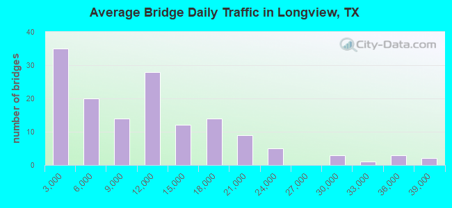
- 1,501,072Total average daily traffic
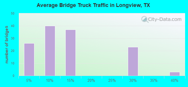
- 209,895Total average daily truck traffic
- National Bridge Inventory (NBI) Registered Bridges for Longview
- No street view available for this location
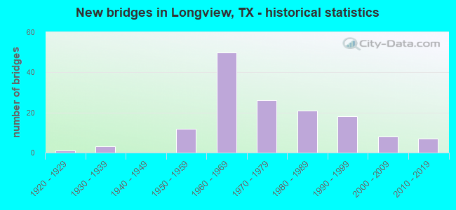
- New bridges - historical statistics
- 11920-1929
- 31930-1939
- 121950-1959
- 501960-1969
- 261970-1979
- 211980-1989
- 181990-1999
- 82000-2009
- 72010-2019
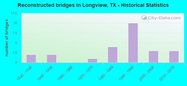
- Reconstructed bridges - Historical Statistics
- 21940-1949
- 21950-1959
- 01960-1969
- 11970-1979
- 41980-1989
- 101990-1999
- 32000-2009
- 32010-2019
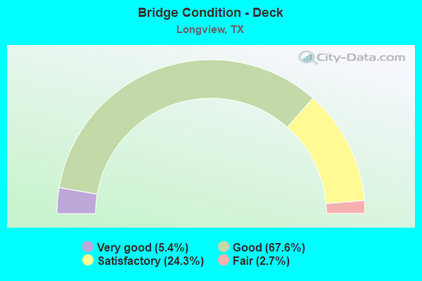
- Bridge Condition - Deck
- 5.4%Very good
- 67.6%Good
- 24.3%Satisfactory
- 2.7%Fair
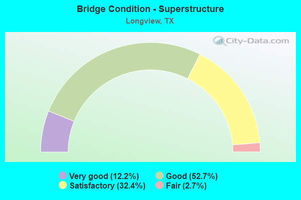
- Bridge Condition - Superstructure
- 12.2%Very good
- 52.7%Good
- 32.4%Satisfactory
- 2.7%Fair
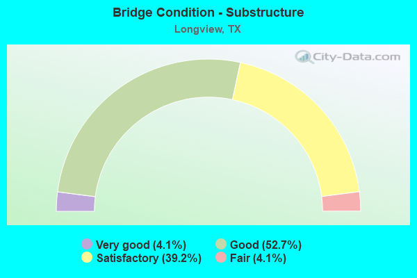
- Bridge Condition - Substructure
- 4.1%Very good
- 52.7%Good
- 39.2%Satisfactory
- 4.1%Fair
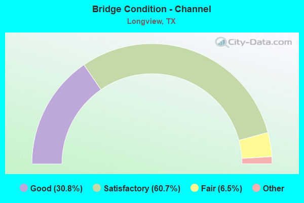
- Bridge Condition - Channel
- 30.8%Very good
- 60.7%Good
- 6.5%Satisfactory
- 1.9%Fair
- 0.9%Poor
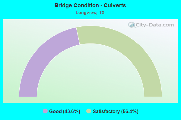
- Bridge Condition - Culverts
- 43.6%Good
- 56.4%Satisfactory
Find on map >> Show street view
Structure Number: 191030288001004, Location: 2.35 MI S OF FM 449 (Lat: 32.567983, Lng: -94.693211), Route carried "on" structure: State highway 2879, Year Built: 1967, Status: Open, Structure Length: 0.64m (2.10ft), Average Daily Traffic: 2,477 (year 2018), Truck Traffic: 14%, Average Future Daily Traffic: 4,820 (year 2033), Design Load: HS 20, Features Intersected: MOCCASIN CREEK
Minimum Vertical Clearance: 30+ m (98+ ft), Kilometerpoint: 11.777, Lanes on structure: 2, Owner: State Highway Agency, Approaching Roadway Width: 7.9m (25.9ft), Material/Design: Concrete, Design/Construction: Culvert, Number Of Spans In Main Unit: 2, Length of Maximum Span: 3.0m (9.8ft), Curb-To-Curb Width: 7.9m (25.9ft), Out-to-Out Width: 13.8m (45.3ft)
Condition: Channel: Good, Culverts: Satisfactory, Operating Rating: 39.9 metric tons, Method Used To Determine Operating Rating: Load Factor (LF), Inventory Rating: 23.6 metric tons, Method Used To Determine Inventory Rating: Load Factor (LF), Structural Evaluation: Equal to present minimum criteria, Deck Geometry: High priority of corrective action, Waterway Adequacy: Equal to present minimum criteria, Approach Roadway Alignment: Equal to present desirable criteria, Designated Inspection Frequency: Every 24 months, Inspection Date: August 2021, Deck Structure Type: Concrete Cast-file-Place, Wearing Surface/Protective System: Wearing Surface: Bituminous
Find on map >> Show street view
Structure Number: 191030AA0506003, Location: 1.4 MI S OF IH 20 (Lat: 32.439981, Lng: -94.670097), Route carried "on" structure: County highway 3321, Year Built: 1994, Status: Open, Structure Length: 1.62m (5.31ft), Average Daily Traffic: 78 (year 2013), Average Future Daily Traffic: 78 (year 2033), Features Intersected: SABINE RIVER TRIBUTARY
Minimum Vertical Clearance: 30+ m (98+ ft), Kilometerpoint: 12.070, Lanes on structure: 2, Owner: County Highway Agency, Approaching Roadway Width: 6.1m (20.0ft), Material/Design: Steel continuous, Design/Construction: Stringer/Multi-beam, Number Of Spans In Main Unit: 2, Length of Maximum Span: 7.6m (24.9ft), Curb-To-Curb Width: 6.9m (22.6ft), Out-to-Out Width: 7.4m (24.3ft)
Condition: Deck: Satisfactory, Superstructure: Satisfactory, Substructure: Satisfactory, Channel: Satisfactory, Operating Rating: 32.7 metric tons, Method Used To Determine Operating Rating: Field evaluation and documented engineering judgment, Inventory Rating: 24.5 metric tons, Method Used To Determine Inventory Rating: Field evaluation and documented engineering judgment, Structural Evaluation: Equal to present minimum criteria, Deck Geometry: Somewhat better than minimum adequacy, Waterway Adequacy: Better than present minimum criteria, Approach Roadway Alignment: Equal to present desirable criteria, Designated Inspection Frequency: Every 24 months, Inspection Date: July 2020, Deck Structure Type: Wood or Timber, Wearing Surface/Protective System: Wearing Surface: Bituminous
Find on map >> Show street view
Structure Number: 191030AA0515002, Location: 0.6 MI E OF LOOP 281 (Lat: 32.480519, Lng: -94.659967), Route carried "on" structure: County highway 3417, Year Built: 1992, Status: Open, Structure Length: 3.66m (12.01ft), Average Daily Traffic: 1,662 (year 2018), Average Future Daily Traffic: 1,082 (year 2033), Design Load: HS 20, Features Intersected: MASON CREEK, Facility Carried by Structure: COUNTRY CLUB RD
Minimum Vertical Clearance: 30+ m (98+ ft), Kilometerpoint: 0.966, Lanes on structure: 2, Owner: County Highway Agency, Approaching Roadway Width: 6.7m (22.0ft), Material/Design: Concrete, Design/Construction: Stringer/Multi-beam, Number Of Spans In Main Unit: 3, Length of Maximum Span: 12.2m (40.0ft), Curb-To-Curb Width: 8.7m (28.5ft), Out-to-Out Width: 9.4m (30.8ft)
Condition: Deck: Good, Superstructure: Good, Substructure: Good, Channel: Good, Operating Rating: 68.0 metric tons, Method Used To Determine Operating Rating: Load Factor (LF), Inventory Rating: 40.8 metric tons, Method Used To Determine Inventory Rating: Load Factor (LF), Structural Evaluation: Better than present minimum criteria, Deck Geometry: Somewhat better than minimum adequacy, Waterway Adequacy: Superior to present desirable criteria, Approach Roadway Alignment: Equal to present desirable criteria, Designated Inspection Frequency: Every 24 months, Inspection Date: July 2020, Deck Structure Type: Concrete Cast-file-Place
Find on map >> Show street view
Structure Number: 100930013801084, Location: 4.50 MI NE OF IH 20 (Lat: 32.478231, Lng: -94.768622), Route carried "under" structure: State highway 281, Year Built: 1975, Structure Length: 0. m, Average Daily Traffic: 17,170 (year 2013), Truck Traffic: 3%, Features Intersected: SL 281, Facility Carried by Structure: SH 31 WB
Minimum Vertical Clearance: 5.33m (17.49ft), Kilometerpoint: 7.875, Lanes on structure: 2, Lanes under structure: 4, Material/Design: Prestressed concrete, Design/Construction: Stringer/Multi-beam, Length of Maximum Span: 25.9m (85.0ft)
Find on map >> Show street view
Structure Number: 100930013801085, Location: 4.50 MI NE OF IH 20 (Lat: 32.477892, Lng: -94.768636), Route carried "under" structure: State highway 281, Year Built: 1975, Structure Length: 0. m, Average Daily Traffic: 17,170 (year 2013), Truck Traffic: 3%, Features Intersected: SL 281, Facility Carried by Structure: SH 31 EB
Minimum Vertical Clearance: 5.56m (18.24ft), Kilometerpoint: 7.875, Lanes on structure: 2, Lanes under structure: 4, Material/Design: Prestressed concrete, Design/Construction: Stringer/Multi-beam, Length of Maximum Span: 25.9m (85.0ft)
Find on map >> Show street view
Structure Number: 10093003920304, Location: 2.60 MI N OF US 80 (Lat: 32.537894, Lng: -94.724253), Route carried "under" structure: Bypass State highway 281, Year Built: 1979, Structure Length: 0. m, Average Daily Traffic: 21,630 (year 2013), Truck Traffic: 10%, Features Intersected: SL 281, Facility Carried by Structure: US 259 SB
Minimum Vertical Clearance: 6.35m (20.83ft), Kilometerpoint: 8.618, Lanes on structure: 2, Lanes under structure: 6, Material/Design: Prestressed concrete, Design/Construction: Stringer/Multi-beam, Length of Maximum Span: 32.0m (105.0ft)
Find on map >> Show street view
Structure Number: 100930039203041, Location: 2.60 MI N OF US 80 (Lat: 32.537767, Lng: -94.723875), Route carried "under" structure: Bypass State highway 281, Year Built: 1979, Structure Length: 0. m, Average Daily Traffic: 23,960 (year 2013), Truck Traffic: 10%, Features Intersected: SL 281, Facility Carried by Structure: US 259 NB
Minimum Vertical Clearance: 5.46m (17.91ft), Kilometerpoint: 8.579, Lanes on structure: 2, Lanes under structure: 6, Material/Design: Prestressed concrete, Design/Construction: Stringer/Multi-beam, Length of Maximum Span: 32.0m (105.0ft)
Find on map >> Show street view
Structure Number: 100930049507298, Location: 0.75 MI W OF US 259 (Lat: 32.445692, Lng: -94.720586), Route carried "under" structure: Interstate 20, Year Built: 1967, Structure Length: 0. m, Average Daily Traffic: 34,120 (year 2013), Truck Traffic: 26%, Features Intersected: IH 20, Facility Carried by Structure: SH 322(ESTES PKWY)
Minimum Vertical Clearance: 5.11m (16.77ft), Kilometerpoint: 25.199, Lanes on structure: 6, Lanes under structure: 5, Material/Design: Steel continuous, Design/Construction: Stringer/Multi-beam, Length of Maximum Span: 22.9m (75.1ft)
Find on map >> Show street view
Structure Number: 100930049507299, Location: 0.30 MI E OF SH 322 (Lat: 32.447089, Lng: -94.716564), Route carried "under" structure: Interstate 20, Year Built: 1967, Structure Length: 0. m, Average Daily Traffic: 32,870 (year 2013), Truck Traffic: 38%, Features Intersected: IH 20, Facility Carried by Structure: MLK BLVD
Minimum Vertical Clearance: 5.54m (18.18ft), Kilometerpoint: 25.624, Lanes on structure: 4, Lanes under structure: 4, Material/Design: Steel continuous, Design/Construction: Stringer/Multi-beam, Length of Maximum Span: 26.5m (86.9ft)
Find on map >> Show street view
Structure Number: 1009300495073, Location: 0.75 MI E OF SH 322 (Lat: 32.450014, Lng: -94.709378), Route carried "under" structure: US 259, Year Built: 1967, Structure Length: 0. m, Average Daily Traffic: 19,370 (year 2013), Truck Traffic: 12%, Features Intersected: US 259 / SH 149, Facility Carried by Structure: IH 20 WB
Minimum Vertical Clearance: 4.88m (16.01ft), Kilometerpoint: 38.198, Lanes on structure: 2, Lanes under structure: 4, Material/Design: Steel continuous, Design/Construction: Stringer/Multi-beam, Length of Maximum Span: 20.7m (67.9ft)
Find on map >> Show street view
Structure Number: 100930049507301, Location: 0.75 MI E OF SH 322 (Lat: 32.449758, Lng: -94.709489), Route carried "under" structure: State highway 149, Year Built: 1967, Structure Length: 0. m, Average Daily Traffic: 11,300 (year 2013), Truck Traffic: 6%, Features Intersected: US 259 / SH 149, Facility Carried by Structure: IH 20 EB
Minimum Vertical Clearance: 5.21m (17.09ft), Kilometerpoint: 38.236, Lanes on structure: 2, Lanes under structure: 4, Material/Design: Steel continuous, Design/Construction: Stringer/Multi-beam, Length of Maximum Span: 20.7m (67.9ft)
Find on map >> Show street view
Structure Number: 1009301763033, Location: 0.42 MI S OF SH 31 (Lat: 32.471583, Lng: -94.767150), Route carried "under" structure: State highway 2087, Year Built: 2016, Structure Length: 0. m, Average Daily Traffic: 2,737 (year 2015), Truck Traffic: 6%, Features Intersected: FM 2087/UPRR, Facility Carried by Structure: SL 281
Minimum Vertical Clearance: 8.08m (26.51ft), Kilometerpoint: 0.853, Lanes on structure: 6, Lanes under structure: 2, Material/Design: Prestressed concrete, Design/Construction: Stringer/Multi-beam, Length of Maximum Span: 35.1m (115.2ft)
Find on map >> Show street view
Structure Number: 100930264201011, Location: 0.60 MI SE OF US 259 (Lat: 32.535017, Lng: -94.715831), Route carried "under" structure: County highway 34, Year Built: 1970, Structure Length: 0. m, Average Daily Traffic: 500 (year 2012), Truck Traffic: 5%, Features Intersected: TRYON ROAD, Facility Carried by Structure: SL 281 WB
Minimum Vertical Clearance: 4.93m (16.17ft), Kilometerpoint: 1.352, Lanes on structure: 2, Lanes under structure: 2, Material/Design: Prestressed concrete, Design/Construction: Stringer/Multi-beam, Length of Maximum Span: 27.4m (89.9ft)
Find on map >> Show street view
Structure Number: 100930264201012, Location: 0.60 MI SE OF US 259 (Lat: 32.534806, Lng: -94.715950), Route carried "under" structure: County highway 34, Year Built: 1970, Structure Length: 0. m, Average Daily Traffic: 500 (year 2010), Truck Traffic: 5%, Features Intersected: TRYON ROAD, Facility Carried by Structure: SL 281 EB
Minimum Vertical Clearance: 5.69m (18.67ft), Kilometerpoint: 1.352, Lanes on structure: 2, Lanes under structure: 2, Material/Design: Prestressed concrete, Design/Construction: Stringer/Multi-beam, Length of Maximum Span: 27.4m (89.9ft)
Find on map >> Show street view
Structure Number: 100930264201104, Location: 1.40 MI SE OF US 259 (Lat: 32.528556, Lng: -94.703000), Route carried "under" structure: Bypass State highway 281, Year Built: 2000, Structure Length: 0. m, Average Daily Traffic: 21,630 (year 2013), Truck Traffic: 10%, Features Intersected: SL 281, Facility Carried by Structure: FM 2208
Minimum Vertical Clearance: 5.84m (19.16ft), Kilometerpoint: 10.834, Lanes on structure: 4, Lanes under structure: 4, Material/Design: Prestressed concrete, Design/Construction: Stringer/Multi-beam, Length of Maximum Span: 29.0m (95.1ft)
Find on map >> Show street view
Structure Number: 100930E00469001, Location: 1.05 MILES S OF US 80 (Lat: 32.484994, Lng: -94.743844), Route carried "under" structure: City street , Year Built: 1951, Structure Length: 0. m, Average Daily Traffic: 200 (year 2012), Truck Traffic: 1%, Features Intersected: UP RR/SABINE ST, Facility Carried by Structure: S HIGH ST
Minimum Vertical Clearance: 5.88m (19.29ft), Kilometerpoint: 0.002, Lanes on structure: 4, Lanes under structure: 2, Material/Design: Steel continuous, Design/Construction: Stringer/Multi-beam, Length of Maximum Span: 21.3m (69.9ft)
Find on map >> Show street view
Structure Number: 191030009607093, Location: 5.95 MI W OF FM 450 (Lat: 32.503989, Lng: -94.672997), Route carried "under" structure: US 80, Year Built: 1967, Structure Length: 0. m, Average Daily Traffic: 12,300 (year 2013), Truck Traffic: 6%, Features Intersected: US 80, Facility Carried by Structure: LP 281 SB
Minimum Vertical Clearance: 5.66m (18.57ft), Kilometerpoint: 2.731, Lanes on structure: 6, Material/Design: Prestressed concrete, Design/Construction: Stringer/Multi-beam, Length of Maximum Span: 21.3m (69.9ft)
Find on map >> Show street view
Structure Number: 191030009607094, Location: 5.95 MI W OF FM 450 (Lat: 32.503994, Lng: -94.672475), Route carried "under" structure: US 80, Year Built: 1967, Structure Length: 0. m, Average Daily Traffic: 20,070 (year 2013), Truck Traffic: 4%, Features Intersected: LP 281 NB, Facility Carried by Structure: LP 281 NB
Minimum Vertical Clearance: 6.55m (21.49ft), Kilometerpoint: 2.755, Lanes on structure: 8, Material/Design: Prestressed concrete, Design/Construction: Stringer/Multi-beam, Length of Maximum Span: 21.3m (69.9ft)
Find on map >> Show street view
Structure Number: 191030049508266, Location: 3.10 MI S OF US 80 (Lat: 32.459889, Lng: -94.667511), Route carried "under" structure: Interstate 20, Year Built: 1966, Structure Length: 0. m, Average Daily Traffic: 34,950 (year 2011), Truck Traffic: 29%, Features Intersected: LP 281 SB, Facility Carried by Structure: LP 281 SB
Minimum Vertical Clearance: 5.51m (18.08ft), Kilometerpoint: 3.405, Lanes on structure: 4, Material/Design: Prestressed concrete, Design/Construction: Stringer/Multi-beam, Length of Maximum Span: 21.3m (69.9ft)
Find on map >> Show street view
Structure Number: 191030049508267, Location: 3.10 MI S OF US 80 (Lat: 32.460225, Lng: -94.667122), Route carried "under" structure: Interstate 20, Year Built: 1966, Structure Length: 0. m, Average Daily Traffic: 34,950 (year 2011), Truck Traffic: 29%, Features Intersected: LP 281 NB, Facility Carried by Structure: LP 281 NB
Minimum Vertical Clearance: 5.82m (19.09ft), Kilometerpoint: 3.431, Lanes on structure: 4, Material/Design: Prestressed concrete, Design/Construction: Stringer/Multi-beam, Length of Maximum Span: 21.3m (69.9ft)