Bridge Statistics for Louisville, Mississippi (MS)
Condition, Traffic, Stress, Structural Evaluation, Project Costs
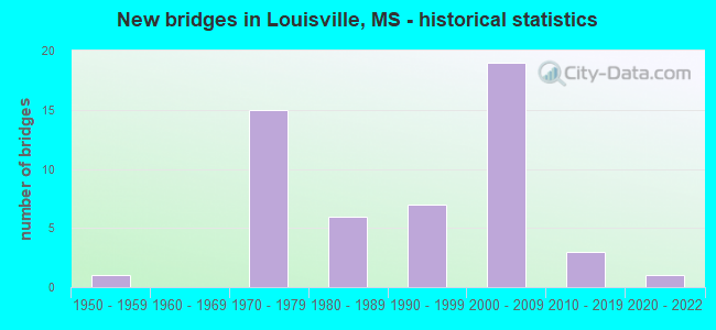
- New bridges - historical statistics
- 11950-1959
- 151970-1979
- 61980-1989
- 71990-1999
- 192000-2009
- 32010-2019
- 12020-2022
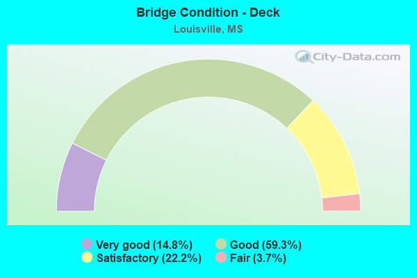
- Bridge Condition - Deck
- 14.8%Very good
- 59.3%Good
- 22.2%Satisfactory
- 3.7%Fair

- Bridge Condition - Superstructure
- 51.9%Very good
- 37.0%Good
- 11.1%Satisfactory
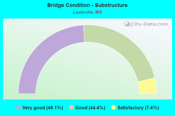
- Bridge Condition - Substructure
- 48.1%Very good
- 44.4%Good
- 7.4%Satisfactory
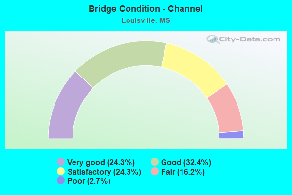
- Bridge Condition - Channel
- 24.3%Very good
- 32.4%Good
- 24.3%Satisfactory
- 16.2%Fair
- 2.7%Poor
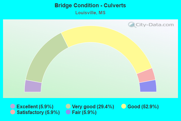
- Bridge Condition - Culverts
- 5.9%Excellent
- 29.4%Very good
- 52.9%Good
- 5.9%Satisfactory
- 5.9%Fair
Find on map >> Show street view
Structure Number: 31000150801921A, Location: SR 15 SOUTH OVER SR 25 (Lat: 33.107719, Lng: -89.080000), Route carried "under" structure: State highway 25, Year Built: 2001, Structure Length: 0. m, Average Daily Traffic: 2,350 (year 2017), Truck Traffic: 8%, Features Intersected: SR 25, Facility Carried by Structure: SR 15
Minimum Vertical Clearance: 5.76m (18.90ft), Kilometerpoint: 30.792, Lanes on structure: 2, Lanes under structure: 5, Material/Design: Prestressed concrete, Design/Construction: Stringer/Multi-beam, Length of Maximum Span: 31.1m (102.0ft)
Find on map >> Show street view
Structure Number: 31000150801921A, Location: SR 15 SOUTH OVER SR 25 (Lat: 33.107861, Lng: -89.080281), Route carried "under" structure: State highway 25, Year Built: 2001, Structure Length: 0. m, Average Daily Traffic: 2,350 (year 2017), Truck Traffic: 8%, Features Intersected: SR 25, Facility Carried by Structure: SR 15
Minimum Vertical Clearance: 6.04m (19.82ft), Kilometerpoint: 25.991, Lanes on structure: 2, Lanes under structure: 5, Material/Design: Prestressed concrete, Design/Construction: Stringer/Multi-beam, Length of Maximum Span: 31.1m (102.0ft)
Find on map >> Show street view
Structure Number: 31000150801921B, Location: SR 15 SOUTH OVER SR 25 (Lat: 33.108069, Lng: -89.080261), Route carried "under" structure: State highway 25, Year Built: 2001, Structure Length: 0. m, Average Daily Traffic: 2,300 (year 2017), Truck Traffic: 8%, Features Intersected: SR 25, Facility Carried by Structure: SR 15
Minimum Vertical Clearance: 5.36m (17.59ft), Kilometerpoint: 25.968, Lanes on structure: 1, Lanes under structure: 5, Material/Design: Prestressed concrete, Design/Construction: Stringer/Multi-beam, Length of Maximum Span: 31.4m (103.0ft)
Find on map >> Show street view
Structure Number: 31000150801921B, Location: SR 15 SOUTH OVER SR 25 (Lat: 33.107919, Lng: -89.079981), Route carried "under" structure: State highway 25, Year Built: 2001, Structure Length: 0. m, Average Daily Traffic: 2,300 (year 2017), Truck Traffic: 8%, Features Intersected: SR 25, Facility Carried by Structure: SR 15
Minimum Vertical Clearance: 5.12m (16.80ft), Kilometerpoint: 30.814, Lanes on structure: 1, Lanes under structure: 5, Material/Design: Prestressed concrete, Design/Construction: Stringer/Multi-beam, Length of Maximum Span: 31.4m (103.0ft)
Find on map >> Show street view
Structure Number: 31000250800396A, Location: SR 25 OVER SR 15 NORTH (Lat: 33.157061, Lng: -89.087369), Route carried "under" structure: State highway 15, Year Built: 2001, Structure Length: 0. m, Average Daily Traffic: 1,250 (year 2017), Truck Traffic: 5%, Features Intersected: SR 15, Facility Carried by Structure: SR 25
Minimum Vertical Clearance: 6.40m (21.00ft), Kilometerpoint: 1.699, Lanes on structure: 3, Lanes under structure: 6, Material/Design: Prestressed concrete continuous, Design/Construction: Stringer/Multi-beam, Length of Maximum Span: 37.5m (123.0ft)
Find on map >> Show street view
Structure Number: 31000250800396A, Location: SR 25 OVER SR 15 NORTH (Lat: 33.157369, Lng: -89.087069), Route carried "under" structure: State highway 15, Year Built: 2001, Structure Length: 0. m, Average Daily Traffic: 1,250 (year 2017), Truck Traffic: 5%, Features Intersected: SR 15, Facility Carried by Structure: SR 25
Minimum Vertical Clearance: 5.64m (18.50ft), Kilometerpoint: 26.409, Lanes on structure: 3, Lanes under structure: 6, Material/Design: Prestressed concrete continuous, Design/Construction: Stringer/Multi-beam, Length of Maximum Span: 37.5m (123.0ft)
Find on map >> Show street view
Structure Number: 31000250800396B, Location: SR 25 OVER SR 15 NORTH (Lat: 33.156700, Lng: -89.087181), Route carried "under" structure: State highway 15, Year Built: 2005, Structure Length: 0. m, Average Daily Traffic: 3,450 (year 2017), Truck Traffic: 5%, Features Intersected: SR 15, Facility Carried by Structure: SR 25
Minimum Vertical Clearance: 5.79m (19.00ft), Kilometerpoint: 1.743, Lanes on structure: 2, Lanes under structure: 6, Material/Design: Prestressed concrete continuous, Design/Construction: Stringer/Multi-beam, Length of Maximum Span: 37.5m (123.0ft)
Find on map >> Show street view
Structure Number: 31000250800396B, Location: SR 25 OVER SR 15 NORTH (Lat: 33.157011, Lng: -89.086889), Route carried "under" structure: State highway 15, Year Built: 2005, Structure Length: 0. m, Average Daily Traffic: 3,450 (year 2017), Truck Traffic: 5%, Features Intersected: SR 15, Facility Carried by Structure: SR 25
Minimum Vertical Clearance: 5.21m (17.09ft), Kilometerpoint: 26.366, Lanes on structure: 2, Lanes under structure: 6, Material/Design: Prestressed concrete continuous, Design/Construction: Stringer/Multi-beam, Length of Maximum Span: 37.5m (123.0ft)