Bridge Statistics for Lynchburg, Tennessee (TN)
Condition, Traffic, Stress, Structural Evaluation, Project Costs
- National Bridge Inventory (NBI) Statistics
- 171Number of bridges
- 1,138ft / 347mTotal length
- $21,259,000Total costs
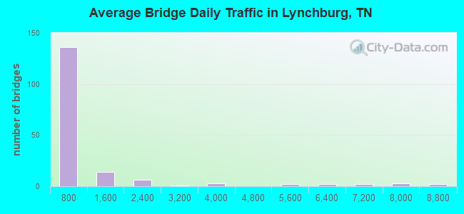
- 141,900Total average daily traffic
- 11,640Total average daily truck traffic
- 247,576Total future (year 2039) average daily traffic
- National Bridge Inventory (NBI) Registered Bridges for Lynchburg
- No street view available for this location
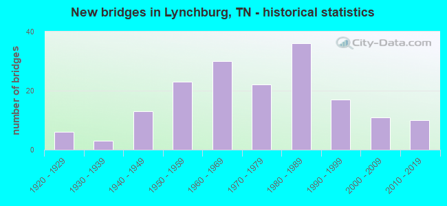
- New bridges - historical statistics
- 61920-1929
- 31930-1939
- 131940-1949
- 231950-1959
- 301960-1969
- 221970-1979
- 361980-1989
- 171990-1999
- 112000-2009
- 102010-2019
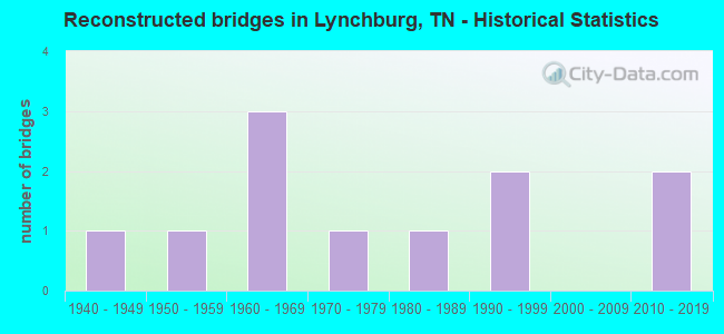
- Reconstructed bridges - Historical Statistics
- 11940-1949
- 11950-1959
- 31960-1969
- 11970-1979
- 11980-1989
- 21990-1999
- 02000-2009
- 22010-2019
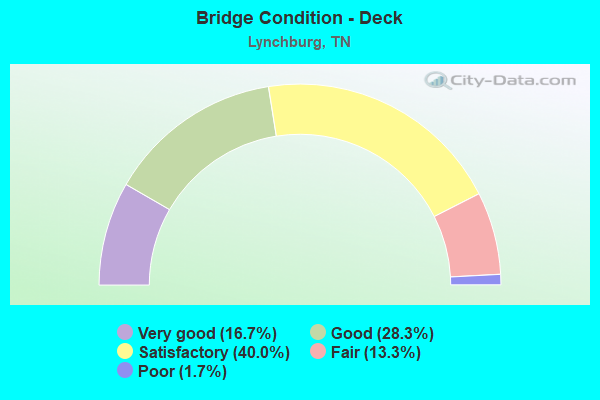
- Bridge Condition - Deck
- 16.7%Very good
- 28.3%Good
- 40.0%Satisfactory
- 13.3%Fair
- 1.7%Poor
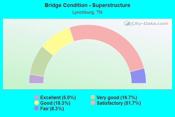
- Bridge Condition - Superstructure
- 5.0%Excellent
- 16.7%Very good
- 18.3%Good
- 51.7%Satisfactory
- 8.3%Fair
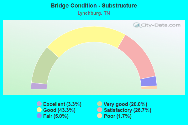
- Bridge Condition - Substructure
- 3.3%Excellent
- 20.0%Very good
- 43.3%Good
- 26.7%Satisfactory
- 5.0%Fair
- 1.7%Poor
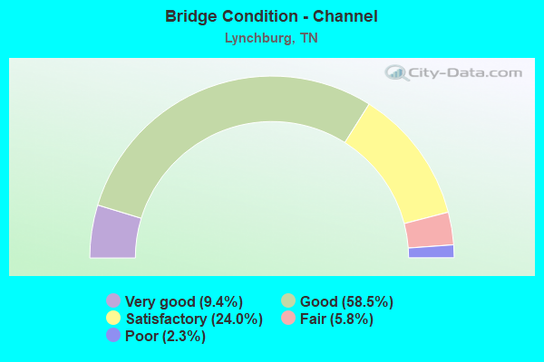
- Bridge Condition - Channel
- 9.4%Very good
- 58.5%Good
- 24.0%Satisfactory
- 5.8%Fair
- 2.3%Poor
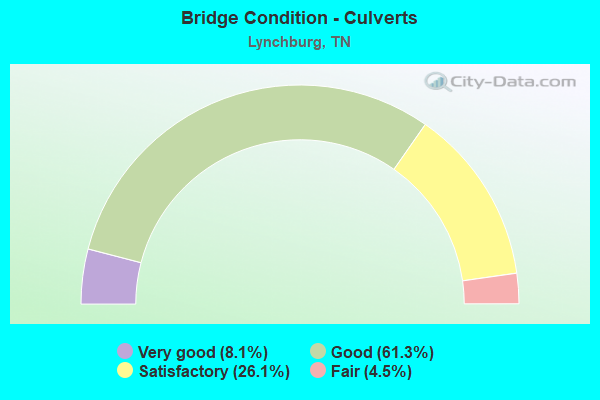
- Bridge Condition - Culverts
- 8.1%Very good
- 61.3%Good
- 26.1%Satisfactory
- 4.5%Fair
Find on map >> Show street view
Structure Number: 64SR0550011, Location: 1.24 MI NE OF LYNCHBURG (Lat: 35.323056, Lng: -86.353528), Route carried "on" structure: State highway 55, Year Built: 2008, Status: Open, Structure Length: 1.16m (3.81ft), Average Daily Traffic: 6,924 (year 2020), Truck Traffic: 11%, Average Future Daily Traffic: 11,312 (year 2040), Design Load: HS 20, Features Intersected: BRANCH
Minimum Vertical Clearance: 30+ m (98+ ft), Kilometerpoint: 7.274, Lanes on structure: 2, Base Highway Network: Yes, Owner: State Highway Agency, Approaching Roadway Width: 9.2m (30.2ft), Material/Design: Concrete continuous, Design/Construction: Culvert, Number Of Spans In Main Unit: 2, Length of Maximum Span: 5.5m (18.0ft), Curb-To-Curb Width: 13.4m (44.0ft), Out-to-Out Width: 16.8m (55.1ft)
Condition: Channel: Satisfactory, Culverts: Good, Operating Rating: 54.1 metric tons, Method Used To Determine Operating Rating: Assigned ratings based on Load and Resistance Factor Design (LRFD) reported by rating factor (RF) using HL93 loadings, Inventory Rating: 32.4 metric tons, Method Used To Determine Inventory Rating: Assigned ratings based on Load and Resistance Factor Design (LRFD) reported by rating factor (RF) using HL93 loadings, Structural Evaluation: Better than present minimum criteria, Deck Geometry: Equal to present minimum criteria, Waterway Adequacy: Equal to present desirable criteria, Approach Roadway Alignment: Equal to present desirable criteria, Designated Inspection Frequency: Every 24 months, Inspection Date: May 2020, Deck Structure Type: Concrete Cast-file-Place, Wearing Surface/Protective System: Wearing Surface: Bituminous, Deck Protection: Epoxy Coated Reinforcing
Find on map >> Show street view
Structure Number: 64SR0550013, Location: 4.1 MI NE OF LYNCHBURG (Lat: 35.342833, Lng: -86.347861), Route carried "on" structure: State highway 55, Year Built: 1953, Status: Open, Structure Length: 1.49m (4.89ft), Average Daily Traffic: 5,728 (year 2020), Truck Traffic: 11%, Average Future Daily Traffic: 8,976 (year 2040), Design Load: H 15, Features Intersected: BOBO CREEK
Minimum Vertical Clearance: 30+ m (98+ ft), Kilometerpoint: 9.576, Lanes on structure: 2, Base Highway Network: Yes, Owner: State Highway Agency, Approaching Roadway Width: 8.5m (27.9ft), Material/Design: Steel continuous, Design/Construction: Stringer/Multi-beam, Number Of Spans In Main Unit: 2, Length of Maximum Span: 7.3m (24.0ft), Curb-To-Curb Width: 8.6m (28.2ft), Out-to-Out Width: 10.5m (34.4ft)
Condition: Deck: Satisfactory, Superstructure: Fair, Substructure: Good, Channel: Good, Operating Rating: 62.5 metric tons, Method Used To Determine Operating Rating: Load Factor (LF), Inventory Rating: 24.3 metric tons, Method Used To Determine Inventory Rating: Load Factor (LF), Structural Evaluation: Somewhat better than minimum adequacy, Deck Geometry: High priority of replacement, Waterway Adequacy: Equal to present desirable criteria, Approach Roadway Alignment: Equal to present desirable criteria, Length Of Structure Improvement: 2.17m (7.12ft), Designated Inspection Frequency: Every 24 months, Inspection Date: May 2020, Bridge Improvement Cost: $617,000, Roadway Improvement Cost: $62,000, Total Project Cost: $926,000 ( Estimate for 2020), Deck Structure Type: Concrete Cast-file-Place, Wearing Surface/Protective System: Wearing Surface: Bituminous