Bridge Statistics for Maquoketa, Iowa (IA)
Condition, Traffic, Stress, Structural Evaluation, Project Costs
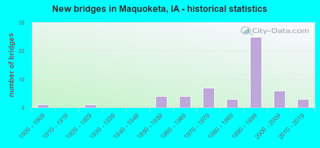
- New bridges - historical statistics
- 11900-1909
- 11920-1929
- 41950-1959
- 41960-1969
- 71970-1979
- 31980-1989
- 251990-1999
- 62000-2009
- 32010-2019
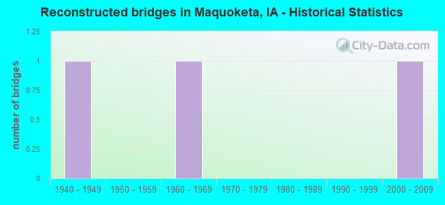
- Reconstructed bridges - Historical Statistics
- 11940-1949
- 01950-1959
- 11960-1969
- 01970-1979
- 01980-1989
- 01990-1999
- 12000-2009
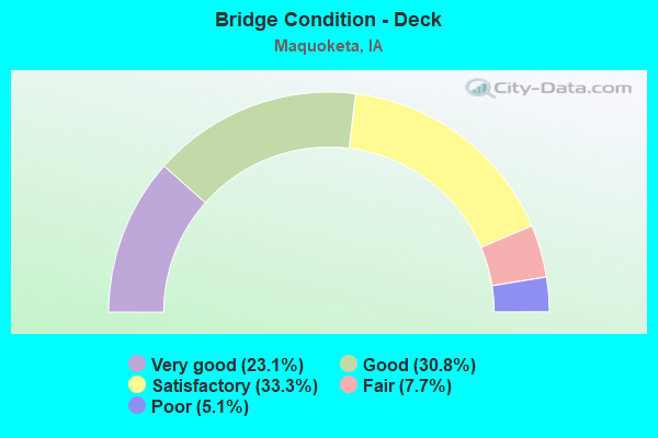
- Bridge Condition - Deck
- 23.1%Very good
- 30.8%Good
- 33.3%Satisfactory
- 7.7%Fair
- 5.1%Poor
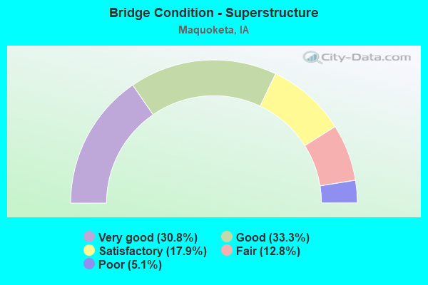
- Bridge Condition - Superstructure
- 30.8%Very good
- 33.3%Good
- 17.9%Satisfactory
- 12.8%Fair
- 5.1%Poor
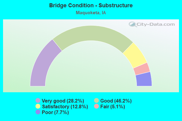
- Bridge Condition - Substructure
- 28.2%Very good
- 46.2%Good
- 12.8%Satisfactory
- 5.1%Fair
- 7.7%Poor
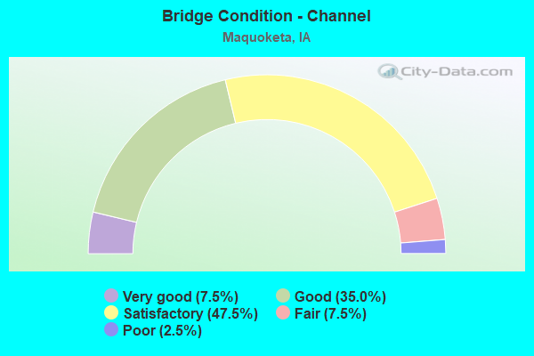
- Bridge Condition - Channel
- 7.5%Very good
- 35.0%Good
- 47.5%Satisfactory
- 7.5%Fair
- 2.5%Poor
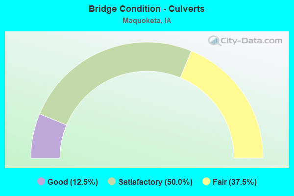
- Bridge Condition - Culverts
- 12.5%Good
- 50.0%Satisfactory
- 37.5%Fair
Find on map >> Show street view
Structure Number: 606395, Location: At jct. U.S. 61 (Lat: 42.044692, Lng: -90.664983), Route carried "on" structure: City street , Year Built: 1996, Status: Open, Structure Length: 8.63m (28.31ft), Average Daily Traffic: 3,440 (year 2017), Average Future Daily Traffic: 3,440 (year 2042), Design Load: HS 20, Features Intersected: U.S. 61, Facility Carried by Structure: SOUTH MAIN ST
Minimum Vertical Clearance: 30+ m (98+ ft), Kilometerpoint: 0.280, Lanes on structure: 2, Lanes under structure: 5, Owner: State Highway Agency, Approaching Roadway Width: 12.8m (42.0ft), Material/Design: Prestressed concrete, Design/Construction: Stringer/Multi-beam, Number Of Spans In Main Unit: 4, Length of Maximum Span: 29.6m (97.1ft), Curb-To-Curb Width: 12.2m (40.0ft), Out-to-Out Width: 13.2m (43.3ft)
Condition: Deck: Satisfactory, Superstructure: Very good, Substructure: Good, Operating Rating: 75.1 metric tons, Method Used To Determine Operating Rating: Load Factor (LF), Inventory Rating: 35.0 metric tons, Method Used To Determine Inventory Rating: Load Factor (LF), Structural Evaluation: Better than present minimum criteria, Deck Geometry: Equal to present minimum criteria, Underclear: Superior to present desirable criteria, Approach Roadway Alignment: Equal to present desirable criteria, Designated Inspection Frequency: Every 24 months, Inspection Date: January 2022, Deck Structure Type: Concrete Cast-file-Place, Wearing Surface/Protective System: Wearing Surface: Monolithic Concrete, Deck Protection: Epoxy Coated Reinforcing
Find on map >> Show street view
Structure Number: 60648, Location: 0.5 MI. N OF JCT. IA #64 (Lat: 42.076056, Lng: -90.683158), Route carried "on" structure: US 61, Year Built: 1998, Status: Open, Structure Length: 12.37m (40.58ft), Average Daily Traffic: 4,100 (year 2020), Truck Traffic: 22%, Average Future Daily Traffic: 4,100 (year 2040), Design Load: HS 20, Features Intersected: S FORK MAQUOKET RIVER
Minimum Vertical Clearance: 30+ m (98+ ft), Kilometerpoint: 51.819, Lanes on structure: 2, Owner: State Highway Agency, Approaching Roadway Width: 13.4m (44.0ft), Skew: 2 degrees, Material/Design: Steel continuous, Design/Construction: Stringer/Multi-beam, Number Of Spans In Main Unit: 3, Length of Maximum Span: 48.5m (159.1ft), Curb-To-Curb Width: 12.2m (40.0ft), Out-to-Out Width: 13.2m (43.3ft)
Condition: Deck: Satisfactory, Superstructure: Good, Substructure: Good, Channel: Good, Operating Rating: 66.1 metric tons, Method Used To Determine Operating Rating: Load Factor (LF), Inventory Rating: 39.7 metric tons, Method Used To Determine Inventory Rating: Load Factor (LF), Structural Evaluation: Better than present minimum criteria, Deck Geometry: Better than present minimum criteria, Waterway Adequacy: Better than present minimum criteria, Approach Roadway Alignment: Equal to present desirable criteria, Designated Inspection Frequency: Every 24 months, Inspection Date: April 2020, Deck Structure Type: Concrete Cast-file-Place, Wearing Surface/Protective System: Wearing Surface: Monolithic Concrete, Deck Protection: Epoxy Coated Reinforcing
Find on map >> Show street view
Structure Number: 60674, Location: AT JCT. OF IA 64 (Lat: 42.068506, Lng: -90.683061), Route carried "on" structure: US 61, Year Built: 1997, Status: Open, Structure Length: 6.19m (20.31ft), Average Daily Traffic: 2,750 (year 2020), Truck Traffic: 29%, Average Future Daily Traffic: 2,750 (year 2041), Design Load: HS 20, Features Intersected: IA 64
Minimum Vertical Clearance: 30+ m (98+ ft), Kilometerpoint: 257.477, Lanes on structure: 2, Lanes under structure: 3, Base Highway Network: Yes, Owner: State Highway Agency, Approaching Roadway Width: 12.8m (42.0ft), Material/Design: Prestressed concrete, Design/Construction: Stringer/Multi-beam, Number Of Spans In Main Unit: 3, Length of Maximum Span: 32.6m (107.0ft), Curb-To-Curb Width: 12.2m (40.0ft), Out-to-Out Width: 13.2m (43.3ft)
Condition: Deck: Good, Superstructure: Good, Substructure: Good, Operating Rating: 64.1 metric tons, Method Used To Determine Operating Rating: Load Factor (LF), Inventory Rating: 32.9 metric tons, Method Used To Determine Inventory Rating: Load Factor (LF), Structural Evaluation: Better than present minimum criteria, Deck Geometry: Better than present minimum criteria, Underclear: Better than present minimum criteria, Approach Roadway Alignment: Equal to present desirable criteria, Designated Inspection Frequency: Every 24 months, Inspection Date: December 2021, Deck Structure Type: Concrete Cast-file-Place, Wearing Surface/Protective System: Wearing Surface: Monolithic Concrete, Deck Protection: Epoxy Coated Reinforcing
Find on map >> Show street view
Structure Number: 606745, Location: AT JCT. OF IA 64 (Lat: 42.069067, Lng: -90.683292), Route carried "on" structure: US 61, Year Built: 1997, Status: Open, Structure Length: 6.19m (20.31ft), Average Daily Traffic: 2,750 (year 2020), Truck Traffic: 29%, Average Future Daily Traffic: 2,750 (year 2041), Design Load: HS 20, Features Intersected: IA 64
Minimum Vertical Clearance: 30+ m (98+ ft), Kilometerpoint: 52.595, Lanes on structure: 2, Lanes under structure: 3, Owner: State Highway Agency, Approaching Roadway Width: 12.8m (42.0ft), Material/Design: Prestressed concrete, Design/Construction: Stringer/Multi-beam, Number Of Spans In Main Unit: 3, Length of Maximum Span: 32.6m (107.0ft), Curb-To-Curb Width: 12.2m (40.0ft), Out-to-Out Width: 13.2m (43.3ft)
Condition: Deck: Good, Superstructure: Good, Substructure: Good, Operating Rating: 64.0 metric tons, Method Used To Determine Operating Rating: Load Factor (LF), Inventory Rating: 32.9 metric tons, Method Used To Determine Inventory Rating: Load Factor (LF), Structural Evaluation: Better than present minimum criteria, Deck Geometry: Better than present minimum criteria, Underclear: Better than present minimum criteria, Approach Roadway Alignment: Equal to present desirable criteria, Designated Inspection Frequency: Every 24 months, Inspection Date: December 2021, Deck Structure Type: Concrete Cast-file-Place, Wearing Surface/Protective System: Wearing Surface: Monolithic Concrete, Deck Protection: Epoxy Coated Reinforcing
Find on map >> Show street view
Structure Number: 60675, Location: 0.5 mi. S OF IA #64 (Lat: 42.061353, Lng: -90.683208), Route carried "on" structure: City street , Year Built: 1997, Status: Open, Structure Length: 7.07m (23.20ft), Average Daily Traffic: 3,280 (year 2021), Average Future Daily Traffic: 3,280 (year 2041), Design Load: HS 20, Features Intersected: US 61, Facility Carried by Structure: SUMMIT ST
Minimum Vertical Clearance: 30+ m (98+ ft), Kilometerpoint: 0.311, Lanes on structure: 2, Lanes under structure: 4, Owner: State Highway Agency, Approaching Roadway Width: 9.8m (32.2ft), Skew: 1 degrees, Material/Design: Steel continuous, Design/Construction: Stringer/Multi-beam, Number Of Spans In Main Unit: 3, Length of Maximum Span: 40.2m (131.9ft), Curb or Sidewalk Widths: Left: 2.4m (7.9ft), Right: 0.0m, Curb-To-Curb Width: 9.8m (32.2ft), Out-to-Out Width: 13.4m (44.0ft)
Condition: Deck: Good, Superstructure: Satisfactory, Substructure: Good, Operating Rating: 63.2 metric tons, Method Used To Determine Operating Rating: Load Factor (LF), Inventory Rating: 37.9 metric tons, Method Used To Determine Inventory Rating: Load Factor (LF), Structural Evaluation: Equal to present minimum criteria, Deck Geometry: Meets minimum limits, Underclear: Equal to present minimum criteria, Approach Roadway Alignment: Equal to present minimum criteria, Designated Inspection Frequency: Every 24 months, Inspection Date: December 2021, Deck Structure Type: Concrete Cast-file-Place, Wearing Surface/Protective System: Wearing Surface: Monolithic Concrete, Deck Protection: Epoxy Coated Reinforcing
Find on map >> Show street view
Structure Number: 6017, Location: AT JCT. OF IA 136 (Lat: 42.003306, Lng: -90.657022), Route carried "under" structure: State highway 136, Year Built: 1995, Structure Length: 0. m, Average Daily Traffic: 435 (year 2020), Truck Traffic: 13%, Features Intersected: IA 136, Facility Carried by Structure: NB US 61
Minimum Vertical Clearance: 30+ m (98+ ft), Kilometerpoint: 48.963, Lanes on structure: 2, Lanes under structure: 2, Material/Design: Prestressed concrete, Design/Construction: Stringer/Multi-beam, Length of Maximum Span: 29.9m (98.1ft)
Find on map >> Show street view
Structure Number: 601705, Location: AT JCT. OF IA. 136 (Lat: 42.003872, Lng: -90.657417), Route carried "under" structure: State highway 136, Year Built: 1995, Structure Length: 0. m, Average Daily Traffic: 870 (year 2020), Truck Traffic: 13%, Features Intersected: IA 136, Facility Carried by Structure: SB US 61
Minimum Vertical Clearance: 30+ m (98+ ft), Kilometerpoint: 48.992, Lanes on structure: 2, Lanes under structure: 2, Material/Design: Prestressed concrete, Design/Construction: Stringer/Multi-beam, Length of Maximum Span: 28.0m (91.9ft)
Find on map >> Show street view
Structure Number: 606385, Location: 1.0 MI. N OF JCT. IA #136 (Lat: 42.018175, Lng: -90.656931), Route carried "under" structure: US 61, Year Built: 1996, Structure Length: 0. m, Average Daily Traffic: 8,500 (year 2020), Truck Traffic: 18%, Features Intersected: US 61, Facility Carried by Structure: 110TH ST
Minimum Vertical Clearance: 30+ m (98+ ft), Kilometerpoint: 250.230, Lanes on structure: 2, Lanes under structure: 4, Material/Design: Prestressed concrete, Design/Construction: Stringer/Multi-beam, Length of Maximum Span: 29.3m (96.1ft)
Find on map >> Show street view
Structure Number: 606395, Location: At jct. U.S. 61 (Lat: 42.044692, Lng: -90.664983), Route carried "under" structure: US 61, Year Built: 1996, Structure Length: 0. m, Average Daily Traffic: 6,300 (year 2020), Truck Traffic: 26%, Features Intersected: U.S. 61, Facility Carried by Structure: SOUTH MAIN ST
Minimum Vertical Clearance: 30+ m (98+ ft), Kilometerpoint: 253.763, Lanes on structure: 2, Lanes under structure: 5, Material/Design: Prestressed concrete, Design/Construction: Stringer/Multi-beam, Length of Maximum Span: 29.6m (97.1ft)
Find on map >> Show street view
Structure Number: 60674, Location: AT JCT. OF IA 64 (Lat: 42.068506, Lng: -90.683061), Route carried "under" structure: State highway 64, Year Built: 1997, Structure Length: 0. m, Average Daily Traffic: 2,750 (year 2020), Truck Traffic: 6%, Features Intersected: IA 64, Facility Carried by Structure: NB US 61
Minimum Vertical Clearance: 30+ m (98+ ft), Kilometerpoint: 52.901, Lanes on structure: 2, Lanes under structure: 3, Material/Design: Prestressed concrete, Design/Construction: Stringer/Multi-beam, Length of Maximum Span: 32.6m (107.0ft)
Find on map >> Show street view
Structure Number: 606745, Location: AT JCT. OF IA 64 (Lat: 42.069067, Lng: -90.683292), Route carried "under" structure: State highway 64, Year Built: 1997, Structure Length: 0. m, Average Daily Traffic: 2,750 (year 2020), Truck Traffic: 6%, Features Intersected: IA 64, Facility Carried by Structure: SB US 61
Minimum Vertical Clearance: 30+ m (98+ ft), Kilometerpoint: 52.885, Lanes on structure: 2, Lanes under structure: 3, Material/Design: Prestressed concrete, Design/Construction: Stringer/Multi-beam, Length of Maximum Span: 32.6m (107.0ft)
Find on map >> Show street view
Structure Number: 60675, Location: 0.5 mi. S OF IA #64 (Lat: 42.061353, Lng: -90.683208), Route carried "under" structure: US 61, Year Built: 1997, Structure Length: 0. m, Average Daily Traffic: 7,300 (year 2020), Truck Traffic: 25%, Features Intersected: US 61, Facility Carried by Structure: SUMMIT ST
Minimum Vertical Clearance: 30+ m (98+ ft), Kilometerpoint: 256.669, Lanes on structure: 2, Lanes under structure: 4, Material/Design: Steel continuous, Design/Construction: Stringer/Multi-beam, Length of Maximum Span: 40.2m (131.9ft)