Bridge Statistics for Marion, Indiana (IN)
Condition, Traffic, Stress, Structural Evaluation, Project Costs
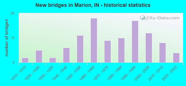
- New bridges - historical statistics
- 21910-1919
- 51920-1929
- 21930-1939
- 61940-1949
- 111950-1959
- 181960-1969
- 91970-1979
- 101980-1989
- 171990-1999
- 122000-2009
- 82010-2019
- 42020-2022
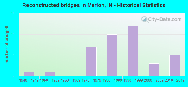
- Reconstructed bridges - Historical Statistics
- 11940-1949
- 11950-1959
- 01960-1969
- 71970-1979
- 101980-1989
- 121990-1999
- 32000-2009
- 52010-2019
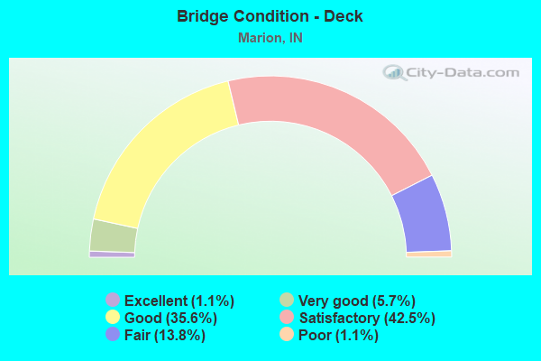
- Bridge Condition - Deck
- 1.1%Excellent
- 5.7%Very good
- 35.6%Good
- 42.5%Satisfactory
- 13.8%Fair
- 1.1%Poor
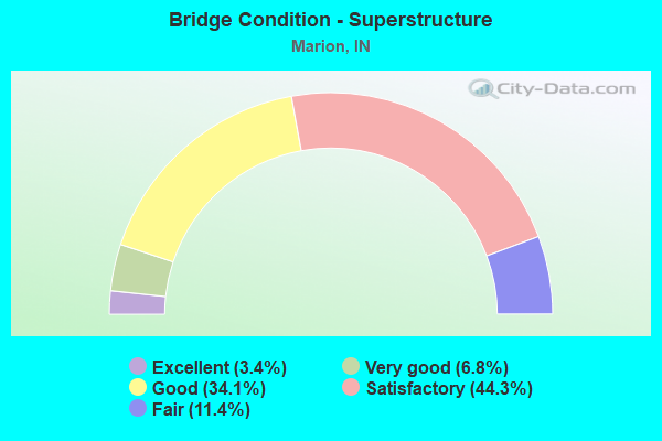
- Bridge Condition - Superstructure
- 3.4%Excellent
- 6.8%Very good
- 34.1%Good
- 44.3%Satisfactory
- 11.4%Fair
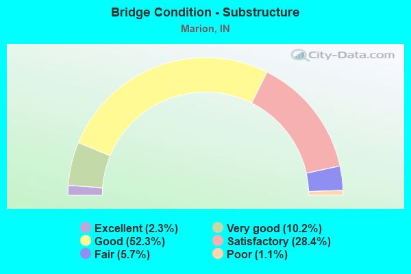
- Bridge Condition - Substructure
- 2.3%Excellent
- 10.2%Very good
- 52.3%Good
- 28.4%Satisfactory
- 5.7%Fair
- 1.1%Poor
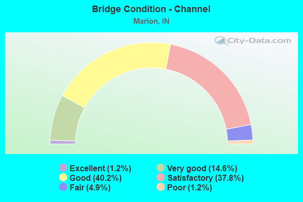
- Bridge Condition - Channel
- 1.2%Excellent
- 14.6%Very good
- 40.2%Good
- 37.8%Satisfactory
- 4.9%Fair
- 1.2%Poor
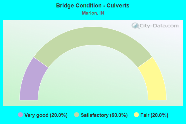
- Bridge Condition - Culverts
- 20.0%Very good
- 60.0%Satisfactory
- 20.0%Fair
Find on map >> Show street view
Structure Number: 2700186, Location: 00.21 MI. S. of SR 18 (Lat: 40.554889, Lng: -85.669239), Route carried "on" structure: City street , Year Built: 1998, Status: Open, Structure Length: 1.52m (4.99ft), Average Daily Traffic: 2,610 (year 2021), Truck Traffic: 5%, Average Future Daily Traffic: 3,990 (year 2041), Design Load: HS 20, Features Intersected: N&S RR, Facility Carried by Structure: D ST
Minimum Vertical Clearance: 30+ m (98+ ft), Kilometerpoint: 0.000, Lanes on structure: 2, Owner: County Highway Agency, Approaching Roadway Width: 7.4m (24.3ft), Skew: 3 degrees, Material/Design: Prestressed concrete, Design/Construction: Box Beam or Girders - Single/Spread, Number Of Spans In Main Unit: 1, Length of Maximum Span: 14.0m (45.9ft), Curb or Sidewalk Widths: Left: 2.0m (6.6ft), Right: 2.0m (6.6ft), Curb-To-Curb Width: 7.4m (24.3ft), Out-to-Out Width: 12.3m (40.4ft)
Condition: Deck: Satisfactory, Superstructure: Satisfactory, Substructure: Good, Operating Rating: 50.2 metric tons, Method Used To Determine Operating Rating: Load Factor (LF), Inventory Rating: 38.7 metric tons, Method Used To Determine Inventory Rating: Load Factor (LF), Structural Evaluation: Equal to present minimum criteria, Deck Geometry: High priority of replacement, Underclear: High priority of corrective action, Approach Roadway Alignment: Equal to present desirable criteria, Designated Inspection Frequency: Every 24 months, Inspection Date: October 2021, Deck Structure Type: Concrete Cast-file-Place, Wearing Surface/Protective System: Wearing Surface: Monolithic Concrete
Find on map >> Show street view
Structure Number: 2700188, Location: 00.30 MI W of CR 600 E (Lat: 40.581569, Lng: -85.565961), Route carried "on" structure: County highway 452, Year Built: 1993, Status: Open, Structure Length: 0.80m (2.62ft), Average Daily Traffic: 710 (year 2021), Truck Traffic: 5%, Average Future Daily Traffic: 1,080 (year 2041), Design Load: HS 20, Features Intersected: TIPPEY DITCH, Facility Carried by Structure: CR 200N
Minimum Vertical Clearance: 30+ m (98+ ft), Kilometerpoint: 0.000, Lanes on structure: 2, Owner: County Highway Agency, Approaching Roadway Width: 6.1m (20.0ft), Skew: 1 degrees, Material/Design: Prestressed concrete, Design/Construction: Box Beam or Girders - Multiple, Number Of Spans In Main Unit: 1, Length of Maximum Span: 6.9m (22.6ft), Curb-To-Curb Width: 7.4m (24.3ft), Out-to-Out Width: 7.5m (24.6ft)
Condition: Deck: Good, Superstructure: Good, Substructure: Satisfactory, Channel: Satisfactory, Operating Rating: 55.5 metric tons, Method Used To Determine Operating Rating: Load Factor (LF), Inventory Rating: 42.8 metric tons, Method Used To Determine Inventory Rating: Load Factor (LF), Structural Evaluation: Equal to present minimum criteria, Deck Geometry: Meets minimum limits, Waterway Adequacy: Better than present minimum criteria, Approach Roadway Alignment: Equal to present desirable criteria, Designated Inspection Frequency: Every 24 months, Inspection Date: October 2021, Deck Structure Type: Concrete Precast Panels, Wearing Surface/Protective System: Wearing Surface: Bituminous
Find on map >> Show street view
Structure Number: 270019, Location: 00.19 MI N of CR 500 S (Lat: 40.482619, Lng: -85.455331), Route carried "on" structure: County highway 75, Year Built: 1992, Status: Open, Structure Length: 1.14m (3.74ft), Average Daily Traffic: 110 (year 2021), Truck Traffic: 5%, Average Future Daily Traffic: 170 (year 2041), Design Load: HS 20, Features Intersected: LITTLE WALNUT CREEK, Facility Carried by Structure: CR 1150E
Minimum Vertical Clearance: 30+ m (98+ ft), Kilometerpoint: 0.000, Lanes on structure: 2, Owner: County Highway Agency, Approaching Roadway Width: 4.6m (15.1ft), Skew: 4 degrees, Material/Design: Prestressed concrete, Design/Construction: Box Beam or Girders - Multiple, Number Of Spans In Main Unit: 1, Length of Maximum Span: 10.7m (35.1ft), Curb-To-Curb Width: 7.4m (24.3ft), Out-to-Out Width: 7.4m (24.3ft)
Condition: Deck: Good, Superstructure: Good, Substructure: Good, Channel: Satisfactory, Operating Rating: 51.3 metric tons, Method Used To Determine Operating Rating: Load Factor (LF), Inventory Rating: 39.6 metric tons, Method Used To Determine Inventory Rating: Load Factor (LF), Structural Evaluation: Better than present minimum criteria, Deck Geometry: Somewhat better than minimum adequacy, Waterway Adequacy: Meets minimum limits, Approach Roadway Alignment: Equal to present desirable criteria, Designated Inspection Frequency: Every 24 months, Inspection Date: October 2021, Deck Structure Type: Concrete Precast Panels, Wearing Surface/Protective System: Wearing Surface: Bituminous
Find on map >> Show street view
Structure Number: 2700194, Location: 01.08 MI N of 38th St (Lat: 40.538939, Lng: -85.627711), Route carried "on" structure: City street , Year Built: 2018, Status: Open, Structure Length: 2.70m (8.86ft), Average Daily Traffic: 1,740 (year 2021), Truck Traffic: 5%, Average Future Daily Traffic: 2,660 (year 2041), Design Load: HL 93, Features Intersected: LUGAR CREEK, Facility Carried by Structure: STONE RD
Minimum Vertical Clearance: 30+ m (98+ ft), Kilometerpoint: 0.000, Lanes on structure: 2, Owner: County Highway Agency, Approaching Roadway Width: 7.3m (24.0ft), Skew: 1 degrees, Material/Design: Concrete continuous, Design/Construction: Slab, Number Of Spans In Main Unit: 3, Length of Maximum Span: 10.7m (35.1ft), Curb-To-Curb Width: 8.5m (27.9ft), Out-to-Out Width: 8.7m (28.5ft)
Condition: Deck: Very good, Superstructure: Very good, Substructure: Very good, Channel: Very good, Operating Rating: 63.5 metric tons, Method Used To Determine Operating Rating: Load and Resistance Factor Rating (LRFR) rating reported by rating factor(RF) method using HL-93 loadings, Inventory Rating: 48.9 metric tons, Method Used To Determine Inventory Rating: Load and Resistance Factor Rating (LRFR) rating reported by rating factor(RF) method using HL-93 loadings, Structural Evaluation: Equal to present desirable criteria, Deck Geometry: Somewhat better than minimum adequacy, Waterway Adequacy: Equal to present desirable criteria, Approach Roadway Alignment: Equal to present desirable criteria, Designated Inspection Frequency: Every 24 months, Inspection Date: October 2021, Deck Structure Type: Concrete Cast-file-Place, Wearing Surface/Protective System: Wearing Surface: Monolithic Concrete, Deck Protection: Epoxy Coated Reinforcing
Find on map >> Show street view
Structure Number: 2700195, Location: 00.88 MI S of SR 18 (Lat: 40.540831, Lng: -85.541400), Route carried "on" structure: City street 257, Year Built: 2020, Status: Open, Structure Length: 2.18m (7.15ft), Average Daily Traffic: 510 (year 2021), Truck Traffic: 5%, Average Future Daily Traffic: 780 (year 2041), Design Load: HS 20, Features Intersected: LUGAR CREEK, Facility Carried by Structure: CR 700E
Minimum Vertical Clearance: 30+ m (98+ ft), Kilometerpoint: 0.000, Lanes on structure: 2, Owner: County Highway Agency, Approaching Roadway Width: 5.5m (18.0ft), Material/Design: Concrete continuous, Design/Construction: Slab, Number Of Spans In Main Unit: 3, Length of Maximum Span: 9.1m (29.9ft), Curb-To-Curb Width: 8.5m (27.9ft), Out-to-Out Width: 8.7m (28.5ft)
Condition: Deck: Very good, Superstructure: Very good, Substructure: Very good, Channel: Very good, Operating Rating: 40.8 metric tons, Method Used To Determine Operating Rating: Field evaluation and documented engineering judgment, Inventory Rating: 32.7 metric tons, Method Used To Determine Inventory Rating: Field evaluation and documented engineering judgment, Structural Evaluation: Equal to present desirable criteria, Deck Geometry: Somewhat better than minimum adequacy, Waterway Adequacy: Better than present minimum criteria, Approach Roadway Alignment: Equal to present desirable criteria, Designated Inspection Frequency: Every 24 months, Inspection Date: October 2021, Deck Structure Type: Concrete Cast-file-Place, Wearing Surface/Protective System: Wearing Surface: Monolithic Concrete, Deck Protection: Epoxy Coated Reinforcing
Find on map >> Show street view
Structure Number: 27002, Location: 01.60 N SR 18 (Lat: 40.576689, Lng: -85.560261), Route carried "on" structure: County highway 49, Year Built: 2012, Status: Open, Structure Length: 1.40m (4.59ft), Average Daily Traffic: 1,500 (year 2021), Truck Traffic: 10%, Average Future Daily Traffic: 2,290 (year 2041), Design Load: HS 20, Features Intersected: TIPPY DITCH, Facility Carried by Structure: CR 600E
Minimum Vertical Clearance: 30+ m (98+ ft), Kilometerpoint: 0.000, Lanes on structure: 2, Owner: County Highway Agency, Approaching Roadway Width: 6.1m (20.0ft), Skew: 1 degrees, Material/Design: Prestressed concrete, Design/Construction: Box Beam or Girders - Multiple, Number Of Spans In Main Unit: 1, Length of Maximum Span: 13.4m (44.0ft), Curb-To-Curb Width: 8.5m (27.9ft), Out-to-Out Width: 8.7m (28.5ft)
Condition: Deck: Good, Superstructure: Good, Substructure: Very good, Channel: Very good, Operating Rating: 42.8 metric tons, Method Used To Determine Operating Rating: Load Factor (LF), Inventory Rating: 33.0 metric tons, Method Used To Determine Inventory Rating: Load Factor (LF), Structural Evaluation: Better than present minimum criteria, Deck Geometry: Somewhat better than minimum adequacy, Waterway Adequacy: Better than present minimum criteria, Approach Roadway Alignment: Equal to present desirable criteria, Designated Inspection Frequency: Every 24 months, Inspection Date: October 2021, Deck Structure Type: Concrete Cast-file-Place, Wearing Surface/Protective System: Wearing Surface: Monolithic Concrete, Deck Protection: Epoxy Coated Reinforcing
Find on map >> Show street view
Structure Number: 2700308, Location: 02.00 N SR 18 (Lat: 40.582819, Lng: -85.579669), Route carried "on" structure: County highway 47, Year Built: 1996, Status: Open, Structure Length: 1.17m (3.84ft), Average Daily Traffic: 530 (year 2021), Truck Traffic: 5%, Average Future Daily Traffic: 810 (year 2041), Design Load: HS 20, Features Intersected: TIPPEY DITCH, Facility Carried by Structure: CR 500E
Minimum Vertical Clearance: 30+ m (98+ ft), Kilometerpoint: 0.000, Lanes on structure: 2, Owner: County Highway Agency, Approaching Roadway Width: 5.2m (17.1ft), Skew: 3 degrees, Material/Design: Prestressed concrete, Design/Construction: Box Beam or Girders - Multiple, Number Of Spans In Main Unit: 1, Length of Maximum Span: 10.9m (35.8ft), Curb-To-Curb Width: 7.3m (24.0ft), Out-to-Out Width: 7.4m (24.3ft)
Condition: Deck: Good, Superstructure: Good, Substructure: Good, Channel: Good, Operating Rating: 62.6 metric tons, Method Used To Determine Operating Rating: Load Factor (LF), Inventory Rating: 48.3 metric tons, Method Used To Determine Inventory Rating: Load Factor (LF), Structural Evaluation: Better than present minimum criteria, Deck Geometry: Meets minimum limits, Waterway Adequacy: Equal to present minimum criteria, Approach Roadway Alignment: Equal to present desirable criteria, Designated Inspection Frequency: Every 24 months, Inspection Date: October 2021, Deck Structure Type: Concrete Precast Panels, Wearing Surface/Protective System: Wearing Surface: Bituminous
Find on map >> Show street view
Structure Number: 2700312, Location: 01.20 MI N of SR 18 (Lat: 40.571081, Lng: -85.560161), Route carried "on" structure: County highway 49, Year Built: 1999, Status: Open, Structure Length: 0.97m (3.18ft), Average Daily Traffic: 1,500 (year 2021), Truck Traffic: 5%, Average Future Daily Traffic: 2,290 (year 2041), Design Load: HS 20, Features Intersected: UNTHANK DITCH, Facility Carried by Structure: CR 600E
Minimum Vertical Clearance: 30+ m (98+ ft), Kilometerpoint: 0.000, Lanes on structure: 2, Owner: County Highway Agency, Approaching Roadway Width: 6.1m (20.0ft), Material/Design: Prestressed concrete, Design/Construction: Box Beam or Girders - Multiple, Number Of Spans In Main Unit: 1, Length of Maximum Span: 9.0m (29.5ft), Curb-To-Curb Width: 7.3m (24.0ft), Out-to-Out Width: 7.5m (24.6ft)
Condition: Deck: Satisfactory, Superstructure: Satisfactory, Substructure: Very good, Channel: Good, Operating Rating: 51.6 metric tons, Method Used To Determine Operating Rating: Load Factor (LF), Inventory Rating: 39.8 metric tons, Method Used To Determine Inventory Rating: Load Factor (LF), Structural Evaluation: Equal to present minimum criteria, Deck Geometry: Meets minimum limits, Waterway Adequacy: Equal to present minimum criteria, Approach Roadway Alignment: Equal to present desirable criteria, Designated Inspection Frequency: Every 24 months, Inspection Date: October 2021, Deck Structure Type: Concrete Precast Panels
Find on map >> Show street view
Structure Number: 2700789, Location: 00.56 MI E of SR 9 (Lat: 40.551889, Lng: -85.664939), Route carried "on" structure: City street , Year Built: 1975, Year Reconstructed: 1995, Status: Open, Structure Length: 0.67m (2.20ft), Average Daily Traffic: 4,000 (year 2021), Truck Traffic: 10%, Average Future Daily Traffic: 6,110 (year 2041), Features Intersected: BOOTS CREEK, Facility Carried by Structure: 10TH ST
Minimum Vertical Clearance: 30+ m (98+ ft), Kilometerpoint: 0.000, Lanes on structure: 2, Owner: County Highway Agency, Approaching Roadway Width: 8.5m (27.9ft), Skew: 1 degrees, Material/Design: Prestressed concrete, Design/Construction: Box Beam or Girders - Multiple, Number Of Spans In Main Unit: 1, Length of Maximum Span: 6.2m (20.3ft), Curb-To-Curb Width: 8.6m (28.2ft), Out-to-Out Width: 8.6m (28.2ft)
Condition: Deck: Fair, Superstructure: Fair, Substructure: Poor, Channel: Satisfactory, Operating Rating: 39.9 metric tons, Method Used To Determine Operating Rating: Load and Resistance Factor Rating (LRFR) rating reported by rating factor(RF) method using HL-93 loadings, Inventory Rating: 30.8 metric tons, Method Used To Determine Inventory Rating: Load and Resistance Factor Rating (LRFR) rating reported by rating factor(RF) method using HL-93 loadings, Structural Evaluation: Meets minimum limits, Deck Geometry: Meets minimum limits, Waterway Adequacy: Somewhat better than minimum adequacy, Approach Roadway Alignment: Equal to present desirable criteria, Length Of Structure Improvement: 1.34m (4.40ft), Designated Inspection Frequency: Every 12 months, Inspection Date: October 2021, Bridge Improvement Cost: $150,000, Roadway Improvement Cost: $100,000, Total Project Cost: $250,000 ( Estimate for 2020), Deck Structure Type: Concrete Precast Panels
Find on map >> Show street view
Structure Number: 2700791, Location: 00.50 MI E of SR 9 (Lat: 40.548361, Lng: -85.665131), Route carried "on" structure: City street , Year Built: 1976, Year Reconstructed: 1998, Status: Open, Structure Length: 0.67m (2.20ft), Average Daily Traffic: 2,580 (year 2021), Truck Traffic: 8%, Average Future Daily Traffic: 3,940 (year 2041), Features Intersected: BOOTS CREEK, Facility Carried by Structure: 14TH ST
Minimum Vertical Clearance: 30+ m (98+ ft), Kilometerpoint: 0.000, Lanes on structure: 2, Owner: County Highway Agency, Approaching Roadway Width: 8.6m (28.2ft), Material/Design: Prestressed concrete, Design/Construction: Box Beam or Girders - Multiple, Number Of Spans In Main Unit: 1, Length of Maximum Span: 6.1m (20.0ft), Curb-To-Curb Width: 8.6m (28.2ft), Out-to-Out Width: 8.6m (28.2ft)
Condition: Deck: Fair, Superstructure: Fair, Substructure: Fair, Channel: Poor, Operating Rating: 33.4 metric tons, Method Used To Determine Operating Rating: Load and Resistance Factor Rating (LRFR) rating reported by rating factor(RF) method using HL-93 loadings, Inventory Rating: 25.6 metric tons, Method Used To Determine Inventory Rating: Load and Resistance Factor Rating (LRFR) rating reported by rating factor(RF) method using HL-93 loadings, Structural Evaluation: Somewhat better than minimum adequacy, Deck Geometry: Meets minimum limits, Waterway Adequacy: Equal to present minimum criteria, Approach Roadway Alignment: Equal to present desirable criteria, Length Of Structure Improvement: 1.34m (4.40ft), Designated Inspection Frequency: Every 24 months, Inspection Date: October 2021, Bridge Improvement Cost: $150,000, Roadway Improvement Cost: $100,000, Total Project Cost: $250,000 ( Estimate for 2017), Deck Structure Type: Concrete Precast Panels, Wearing Surface/Protective System: Wearing Surface: Bituminous
Find on map >> Show street view
Structure Number: 2700792, Location: 00.11 W N MILLER AVE (Lat: 40.581750, Lng: -85.695369), Route carried "on" structure: County highway 60, Year Built: 2000, Status: Open, Structure Length: 0.79m (2.59ft), Average Daily Traffic: 1,130 (year 2021), Truck Traffic: 5%, Average Future Daily Traffic: 1,730 (year 2041), Design Load: HS 20, Features Intersected: LITTLE CRANE POND DITCH, Facility Carried by Structure: CR 200N
Minimum Vertical Clearance: 30+ m (98+ ft), Kilometerpoint: 0.000, Lanes on structure: 2, Owner: County Highway Agency, Approaching Roadway Width: 6.1m (20.0ft), Material/Design: Wood or Timber, Design/Construction: Slab, Number Of Spans In Main Unit: 1, Length of Maximum Span: 7.3m (24.0ft), Curb or Sidewalk Widths: Left: 0.2m (0.7ft), Right: 0.2m (0.7ft), Curb-To-Curb Width: 8.6m (28.2ft), Out-to-Out Width: 9.1m (29.9ft)
Condition: Deck: Good, Superstructure: Good, Substructure: Good, Channel: Satisfactory, Operating Rating: 41.1 metric tons, Method Used To Determine Operating Rating: Load and Resistance Factor Rating (LRFR) rating reported by rating factor(RF) method using HL-93 loadings, Inventory Rating: 31.8 metric tons, Method Used To Determine Inventory Rating: Load and Resistance Factor Rating (LRFR) rating reported by rating factor(RF) method using HL-93 loadings, Structural Evaluation: Better than present minimum criteria, Deck Geometry: Somewhat better than minimum adequacy, Waterway Adequacy: Better than present minimum criteria, Approach Roadway Alignment: Equal to present desirable criteria, Designated Inspection Frequency: Every 24 months, Inspection Date: October 2021, Deck Structure Type: Wood or Timber, Wearing Surface/Protective System: Wearing Surface: Bituminous, Deck Protection: Internally Sealed
Find on map >> Show street view
Structure Number: 2700795, Location: 00.86 MI N of SR 18 (Lat: 40.570981, Lng: -85.645681), Route carried "on" structure: City street , Year Built: 2003, Status: Open, Structure Length: 1.48m (4.86ft), Average Daily Traffic: 6,840 (year 2021), Truck Traffic: 5%, Average Future Daily Traffic: 10,450 (year 2041), Design Load: HS 20, Features Intersected: MASSEY CREEK, Facility Carried by Structure: PENNSYLVANIA ST
Minimum Vertical Clearance: 30+ m (98+ ft), Kilometerpoint: 0.000, Lanes on structure: 2, Owner: County Highway Agency, Approaching Roadway Width: 9.8m (32.2ft), Skew: 2 degrees, Material/Design: Concrete, Design/Construction: Culvert, Number Of Spans In Main Unit: 1, Length of Maximum Span: 14.1m (46.3ft), Curb or Sidewalk Widths: Left: 0.2m (0.7ft), Right: 2.0m (6.6ft), Curb-To-Curb Width: 9.8m (32.2ft), Out-to-Out Width: 27.1m (88.9ft)
Condition: Channel: Good, Culverts: Very good, Operating Rating: 42.3 metric tons, Method Used To Determine Operating Rating: Field evaluation and documented engineering judgment, Inventory Rating: 32.7 metric tons, Method Used To Determine Inventory Rating: Field evaluation and documented engineering judgment, Structural Evaluation: Equal to present desirable criteria, Deck Geometry: Meets minimum limits, Waterway Adequacy: Better than present minimum criteria, Approach Roadway Alignment: Equal to present desirable criteria, Designated Inspection Frequency: Every 24 months, Inspection Date: October 2021, Wearing Surface/Protective System: Wearing Surface: Bituminous
Find on map >> Show street view
Structure Number: 2700797, Location: 00.29 MI E of SR 37 (Lat: 40.451481, Lng: -85.708150), Route carried "on" structure: County highway 265, Year Built: 2005, Status: Open, Structure Length: 1.15m (3.77ft), Average Daily Traffic: 110 (year 2021), Truck Traffic: 5%, Average Future Daily Traffic: 170 (year 2041), Features Intersected: BRANCH OF DEER CREEK, Facility Carried by Structure: CR 700S
Minimum Vertical Clearance: 30+ m (98+ ft), Kilometerpoint: 0.000, Lanes on structure: 2, Owner: County Highway Agency, Approaching Roadway Width: 4.9m (16.1ft), Skew: 4 degrees, Material/Design: Prestressed concrete, Design/Construction: Box Beam or Girders - Multiple, Number Of Spans In Main Unit: 1, Length of Maximum Span: 11.0m (36.1ft), Curb-To-Curb Width: 7.3m (24.0ft), Out-to-Out Width: 7.4m (24.3ft)
Condition: Deck: Satisfactory, Superstructure: Satisfactory, Substructure: Good, Channel: Good, Operating Rating: 47.5 metric tons, Method Used To Determine Operating Rating: Load Factor (LF), Inventory Rating: 36.7 metric tons, Method Used To Determine Inventory Rating: Load Factor (LF), Structural Evaluation: Equal to present minimum criteria, Deck Geometry: Somewhat better than minimum adequacy, Waterway Adequacy: Better than present minimum criteria, Approach Roadway Alignment: Equal to present minimum criteria, Designated Inspection Frequency: Every 24 months, Inspection Date: October 2021, Deck Structure Type: Concrete Precast Panels
Find on map >> Show street view
Structure Number: 2700798, Location: 00.54 MI S of SR 18 (Lat: 40.545669, Lng: -85.616169), Route carried "on" structure: City street , Year Built: 2006, Status: Open, Structure Length: 3.61m (11.84ft), Average Daily Traffic: 790 (year 2021), Truck Traffic: 5%, Average Future Daily Traffic: 1,210 (year 2041), Design Load: HS 20, Features Intersected: LUGAR CREEK, Facility Carried by Structure: 300E-BETHLEHEM RD
Minimum Vertical Clearance: 30+ m (98+ ft), Kilometerpoint: 0.000, Lanes on structure: 2, Owner: County Highway Agency, Approaching Roadway Width: 8.5m (27.9ft), Skew: 2 degrees, Material/Design: Prestressed concrete continuous, Design/Construction: Stringer/Multi-beam, Number Of Spans In Main Unit: 3, Length of Maximum Span: 12.0m (39.4ft), Curb-To-Curb Width: 9.0m (29.5ft), Out-to-Out Width: 9.2m (30.2ft)
Condition: Deck: Good, Superstructure: Very good, Substructure: Good, Channel: Good, Operating Rating: 50.1 metric tons, Method Used To Determine Operating Rating: Load Factor (LF), Inventory Rating: 30.0 metric tons, Method Used To Determine Inventory Rating: Load Factor (LF), Structural Evaluation: Better than present minimum criteria, Deck Geometry: Somewhat better than minimum adequacy, Waterway Adequacy: Superior to present desirable criteria, Approach Roadway Alignment: Equal to present desirable criteria, Designated Inspection Frequency: Every 24 months, Inspection Date: October 2021, Deck Structure Type: Concrete Cast-file-Place, Wearing Surface/Protective System: Wearing Surface: Monolithic Concrete, Deck Protection: Epoxy Coated Reinforcing
Find on map >> Show street view
Structure Number: 261, Location: 00.92 N of SR 15 (Lat: 40.584419, Lng: -85.660958), Route carried "under" structure: City street , Year Built: 1940, Structure Length: 0. m, Average Daily Traffic: 118 (year 2004), Truck Traffic: 5%, Features Intersected: MATTER PARK ROAD, Facility Carried by Structure: SR 9
Minimum Vertical Clearance: 4.55m (14.93ft), Kilometerpoint: 23.352, Lanes on structure: 2, Lanes under structure: 4, Material/Design: Steel continuous, Design/Construction: Stringer/Multi-beam, Length of Maximum Span: 25.6m (84.0ft)
Find on map >> Show street view
Structure Number: 482, Location: 02.14 W SR 9 (Lat: 40.563131, Lng: -85.712378), Route carried "under" structure: County highway , Year Built: 1956, Structure Length: 0. m, Average Daily Traffic: 759 (year 2004), Truck Traffic: 10%, Features Intersected: NORTH TROY ROAD / CR 200, Facility Carried by Structure: SR 18
Minimum Vertical Clearance: 5.72m (18.77ft), Kilometerpoint: 0.000, Lanes on structure: 2, Lanes under structure: 2, Material/Design: Steel continuous, Design/Construction: Stringer/Multi-beam, Length of Maximum Span: 14.7m (48.2ft)
Find on map >> Show street view
Structure Number: 397, Location: 01.99 S SR 18 (Lat: 40.524131, Lng: -85.550042), Route carried "under" structure: Interstate 69, Year Built: 1963, Structure Length: 0. m, Average Daily Traffic: 13,438 (year 2019), Truck Traffic: 38%, Features Intersected: I-69 NB, Facility Carried by Structure: CR 200S
Minimum Vertical Clearance: 5.23m (17.16ft), Kilometerpoint: 421.729, Lanes on structure: 2, Lanes under structure: 4, Material/Design: Concrete continuous, Design/Construction: Stringer/Multi-beam, Length of Maximum Span: 20.0m (65.6ft)
Find on map >> Show street view
Structure Number: 397, Location: 01.99 S SR 18 (Lat: 40.524131, Lng: -85.550042), Route carried "under" structure: Interstate 69, Year Built: 1963, Structure Length: 0. m, Average Daily Traffic: 14,160 (year 2019), Truck Traffic: 38%, Features Intersected: I-69 SB, Facility Carried by Structure: CR 200S
Minimum Vertical Clearance: 5.31m (17.42ft), Kilometerpoint: 421.729, Lanes on structure: 2, Lanes under structure: 4, Material/Design: Concrete continuous, Design/Construction: Stringer/Multi-beam, Length of Maximum Span: 20.0m (65.6ft)
Find on map >> Show street view
Structure Number: 39751, Location: 04.98 N US 35 (Lat: 40.553461, Lng: -85.550697), Route carried "under" structure: State highway 18, Year Built: 2019, Structure Length: 0. m, Average Daily Traffic: 2,980 (year 2019), Truck Traffic: 7%, Features Intersected: SR 18 EB, Facility Carried by Structure: I-69 NB
Minimum Vertical Clearance: 5.05m (16.57ft), Kilometerpoint: 27.809, Lanes on structure: 2, Lanes under structure: 4, Material/Design: Steel continuous, Design/Construction: Stringer/Multi-beam, Length of Maximum Span: 13.6m (44.6ft)
Find on map >> Show street view
Structure Number: 39751, Location: 04.98 N US 35 (Lat: 40.553461, Lng: -85.550697), Route carried "under" structure: State highway 18, Year Built: 2019, Structure Length: 0. m, Average Daily Traffic: 2,980 (year 2019), Truck Traffic: 7%, Features Intersected: SR 18 WB, Facility Carried by Structure: I-69 NB
Minimum Vertical Clearance: 5.05m (16.57ft), Kilometerpoint: 27.809, Lanes on structure: 2, Lanes under structure: 4, Material/Design: Steel continuous, Design/Construction: Stringer/Multi-beam, Length of Maximum Span: 13.6m (44.6ft)
Find on map >> Show street view
Structure Number: 39761, Location: 04.98 N US 35 (Lat: 40.553469, Lng: -85.551019), Route carried "under" structure: State highway 18, Year Built: 2020, Structure Length: 0. m, Average Daily Traffic: 2,980 (year 2020), Truck Traffic: 12%, Features Intersected: SR 18 EB, Facility Carried by Structure: I-69 SB
Minimum Vertical Clearance: 5.05m (16.57ft), Kilometerpoint: 27.809, Lanes on structure: 2, Lanes under structure: 4, Material/Design: Steel continuous, Design/Construction: Stringer/Multi-beam, Length of Maximum Span: 13.6m (44.6ft)
Find on map >> Show street view
Structure Number: 39761, Location: 04.98 N US 35 (Lat: 40.553469, Lng: -85.551019), Route carried "under" structure: State highway 18, Year Built: 2020, Structure Length: 0. m, Average Daily Traffic: 2,980 (year 2020), Truck Traffic: 12%, Features Intersected: SR 18 WB, Facility Carried by Structure: I-69 SB
Minimum Vertical Clearance: 5.05m (16.57ft), Kilometerpoint: 27.809, Lanes on structure: 2, Lanes under structure: 4, Material/Design: Steel continuous, Design/Construction: Stringer/Multi-beam, Length of Maximum Span: 13.6m (44.6ft)
Find on map >> Show street view
Structure Number: 3979, Location: 01.94 N SR 18 (Lat: 40.581150, Lng: -85.551514), Route carried "under" structure: Interstate 69, Year Built: 1963, Structure Length: 0. m, Average Daily Traffic: 14,778 (year 2019), Truck Traffic: 35%, Features Intersected: I-69 NB, Facility Carried by Structure: CR 200N
Minimum Vertical Clearance: 5.03m (16.50ft), Kilometerpoint: 428.053, Lanes on structure: 2, Lanes under structure: 4, Material/Design: Steel continuous, Design/Construction: Stringer/Multi-beam, Length of Maximum Span: 19.8m (65.0ft)
Find on map >> Show street view
Structure Number: 3979, Location: 01.94 N SR 18 (Lat: 40.581150, Lng: -85.551514), Route carried "under" structure: Interstate 69, Year Built: 1963, Structure Length: 0. m, Average Daily Traffic: 14,778 (year 2019), Truck Traffic: 35%, Features Intersected: I-69 SB, Facility Carried by Structure: CR 200N
Minimum Vertical Clearance: 5.13m (16.83ft), Kilometerpoint: 428.053, Lanes on structure: 2, Lanes under structure: 4, Material/Design: Steel continuous, Design/Construction: Stringer/Multi-beam, Length of Maximum Span: 19.8m (65.0ft)
Find on map >> Show street view
Structure Number: 76362, Location: 04.13 S SR 13 (Lat: 39.991081, Lng: -85.919000), Route carried "under" structure: Interstate 69, Year Built: 2010, Structure Length: 0. m, Average Daily Traffic: 30,120 (year 2006), Truck Traffic: 22%, Features Intersected: I-69 SBL, Facility Carried by Structure: OLIO ROAD
Minimum Vertical Clearance: 6.27m (20.57ft), Kilometerpoint: 338.461, Lanes on structure: 4, Lanes under structure: 6, Material/Design: Prestressed concrete continuous, Design/Construction: Tee Beam, Length of Maximum Span: 40.5m (132.9ft)