Bridge Statistics for Marion, North Carolina (NC)
Condition, Traffic, Stress, Structural Evaluation, Project Costs
- New bridges - historical statistics
- 31920-1929
- 11930-1939
- 461950-1959
- 101960-1969
- 81970-1979
- 141980-1989
- 71990-1999
- 162000-2009
- 122010-2019
- Reconstructed bridges - Historical Statistics
- 11930-1939
- 01940-1949
- 01950-1959
- 11960-1969
- 11970-1979
- 31980-1989
- 101990-1999
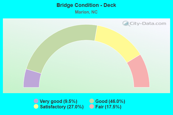
- Bridge Condition - Deck
- 9.5%Very good
- 46.0%Good
- 27.0%Satisfactory
- 17.5%Fair
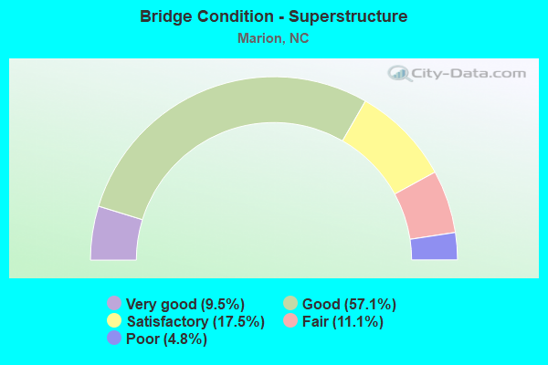
- Bridge Condition - Superstructure
- 9.5%Very good
- 57.1%Good
- 17.5%Satisfactory
- 11.1%Fair
- 4.8%Poor
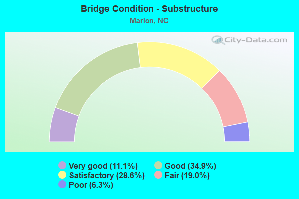
- Bridge Condition - Substructure
- 11.1%Very good
- 34.9%Good
- 28.6%Satisfactory
- 19.0%Fair
- 6.3%Poor
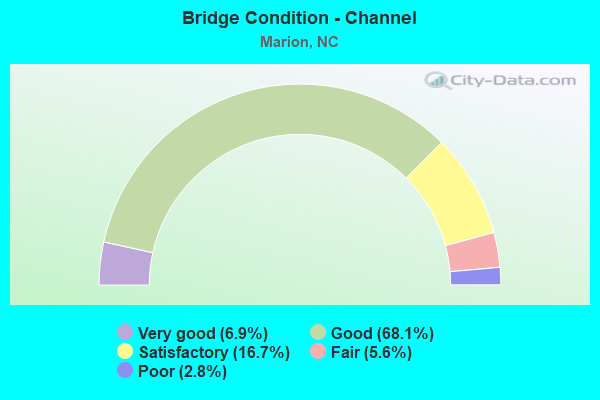
- Bridge Condition - Channel
- 6.9%Very good
- 68.1%Good
- 16.7%Satisfactory
- 5.6%Fair
- 2.8%Poor
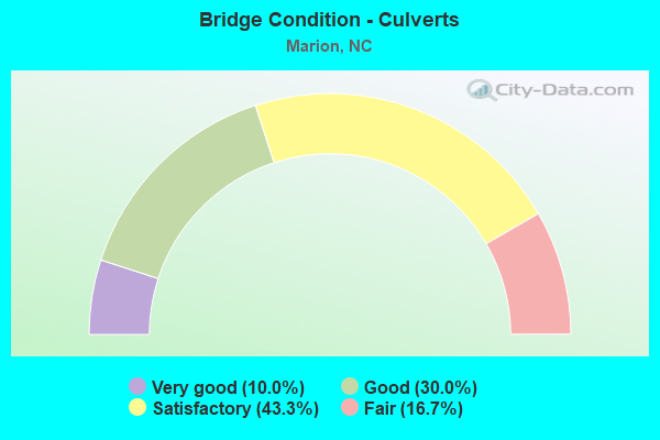
- Bridge Condition - Culverts
- 10.0%Very good
- 30.0%Good
- 43.3%Satisfactory
- 16.7%Fair
Find on map >> Show street view
Structure Number: 1110355, Location: .2 MI.N.JCT.US70 (Lat: 35.707450, Lng: -82.036828), Route carried "on" structure: US 221, Year Built: 1989, Status: Open, Structure Length: 6.40m (21.00ft), Average Daily Traffic: 17,000 (year 2017), Truck Traffic: 12%, Average Future Daily Traffic: 34,000 (year 2040), Design Load: HS 20+Mod, Features Intersected: CATAWBA RIVER
Minimum Vertical Clearance: 30+ m (98+ ft), Kilometerpoint: 0.000, Lanes on structure: 4, Base Highway Network: Yes (Inventory Route: 2, Subroute: 21), Owner: State Highway Agency, Approaching Roadway Width: 20.4m (66.9ft), Skew: 21 degrees, Material/Design: Prestressed concrete, Design/Construction: Stringer/Multi-beam, Number Of Spans In Main Unit: 3, Length of Maximum Span: 21.6m (70.9ft), Curb-To-Curb Width: 23.1m (75.8ft), Out-to-Out Width: 24.1m (79.1ft)
Condition: Deck: Satisfactory, Superstructure: Good, Substructure: Satisfactory, Channel: Good, Operating Rating: 75.2 metric tons, Method Used To Determine Operating Rating: Load Factor (LF), Inventory Rating: 39.0 metric tons, Method Used To Determine Inventory Rating: Load Factor (LF), Structural Evaluation: Equal to present minimum criteria, Deck Geometry: Superior to present desirable criteria, Waterway Adequacy: Better than present minimum criteria, Approach Roadway Alignment: Equal to present desirable criteria, Designated Inspection Frequency: Every 24 months, Underwater Inspection Frequency: Every 60 months, Inspection Date: Febuary 2022, Underwater Inspection Date: July 2019, Deck Structure Type: Concrete Cast-file-Place, Wearing Surface/Protective System: Wearing Surface: Monolithic Concrete, Deck Protection: Epoxy Coated Reinforcing
Find on map >> Show street view
Structure Number: 1110356, Location: .3 MI.N.JCT.US70 (Lat: 35.709889, Lng: -82.037017), Route carried "on" structure: US 221, Year Built: 1989, Status: Open, Structure Length: 9.90m (32.48ft), Average Daily Traffic: 14,000 (year 2018), Truck Traffic: 12%, Average Future Daily Traffic: 28,000 (year 2040), Design Load: HS 20+Mod, Features Intersected: UT TO CATAWBA RIVER
Minimum Vertical Clearance: 30+ m (98+ ft), Kilometerpoint: 0.000, Lanes on structure: 4, Base Highway Network: Yes (Inventory Route: 2, Subroute: 21), Owner: State Highway Agency, Approaching Roadway Width: 19.5m (64.0ft), Skew: 23 degrees, Material/Design: Prestressed concrete, Design/Construction: Stringer/Multi-beam, Number Of Spans In Main Unit: 5, Length of Maximum Span: 19.5m (64.0ft), Curb-To-Curb Width: 21.9m (71.9ft), Out-to-Out Width: 24.1m (79.1ft)
Condition: Deck: Fair, Superstructure: Good, Substructure: Good, Channel: Good, Operating Rating: 83.4 metric tons, Method Used To Determine Operating Rating: Load Factor (LF), Inventory Rating: 38.1 metric tons, Method Used To Determine Inventory Rating: Load Factor (LF), Structural Evaluation: Better than present minimum criteria, Deck Geometry: Superior to present desirable criteria, Waterway Adequacy: Better than present minimum criteria, Approach Roadway Alignment: Equal to present desirable criteria, Designated Inspection Frequency: Every 24 months, Underwater Inspection Frequency: Every 60 months, Inspection Date: Febuary 2020, Underwater Inspection Date: June 2018, Deck Structure Type: Concrete Cast-file-Place, Wearing Surface/Protective System: Wearing Surface: Monolithic Concrete, Deck Protection: Epoxy Coated Reinforcing
Find on map >> Show street view
Structure Number: 1110375, Location: .02MI.S.JCT.RUTHERFORD RD (Lat: 35.676569, Lng: -81.998481), Route carried "on" structure: City street , Year Built: 1960, Status: Open, Structure Length: 0.82m (2.69ft), Average Daily Traffic: 100 (year 1998), Average Future Daily Traffic: 200 (year 2040), Design Load: HS 20, Features Intersected: YOUNGS FORK, Facility Carried by Structure: SHOP DRIVE
Minimum Vertical Clearance: 30+ m (98+ ft), Kilometerpoint: 0.000, Lanes on structure: 2, Owner: City or Municipal Highway Agency, Approaching Roadway Width: 5.4m (17.7ft), Material/Design: Steel, Design/Construction: Stringer/Multi-beam, Number Of Spans In Main Unit: 1, Length of Maximum Span: 7.9m (25.9ft), Curb-To-Curb Width: 5.8m (19.0ft), Out-to-Out Width: 6.6m (21.7ft)
Condition: Deck: Satisfactory, Superstructure: Good, Substructure: Satisfactory, Channel: Good, Operating Rating: 71.6 metric tons, Method Used To Determine Operating Rating: Load Factor (LF), Inventory Rating: 41.7 metric tons, Method Used To Determine Inventory Rating: Load Factor (LF), Structural Evaluation: Equal to present minimum criteria, Deck Geometry: Meets minimum limits, Waterway Adequacy: Better than present minimum criteria, Approach Roadway Alignment: Equal to present desirable criteria, Designated Inspection Frequency: Every 24 months, Inspection Date: May 2020, Deck Structure Type: Concrete Cast-file-Place, Wearing Surface/Protective System: Wearing Surface: Bituminous
Find on map >> Show street view
Structure Number: 1110376, Location: .05MI.S.JCT.RUTHERFORD RD (Lat: 35.675236, Lng: -81.996761), Route carried "on" structure: City street , Year Built: 1994, Status: Open, Structure Length: 0.64m (2.10ft), Average Daily Traffic: 100 (year 1998), Average Future Daily Traffic: 200 (year 2040), Design Load: HS 20, Features Intersected: YOUNGS FORK, Facility Carried by Structure: SHOP DRIVE
Minimum Vertical Clearance: 30+ m (98+ ft), Kilometerpoint: 0.000, Lanes on structure: 2, Owner: City or Municipal Highway Agency, Approaching Roadway Width: 5.4m (17.7ft), Material/Design: Steel, Design/Construction: Culvert, Number Of Spans In Main Unit: 2, Length of Maximum Span: 3.0m (9.8ft), Curb-To-Curb Width: 5.6m (18.4ft), Out-to-Out Width: 6.1m (20.0ft)
Condition: Channel: Good, Culverts: Satisfactory, Operating Rating: 89.8 metric tons, Method Used To Determine Operating Rating: Load Factor (LF), Inventory Rating: 74.3 metric tons, Method Used To Determine Inventory Rating: Load Factor (LF), Structural Evaluation: Equal to present minimum criteria, Deck Geometry: Meets minimum limits, Waterway Adequacy: Better than present minimum criteria, Approach Roadway Alignment: Equal to present desirable criteria, Designated Inspection Frequency: Every 24 months, Inspection Date: May 2020
Find on map >> Show street view
Structure Number: 1110379, Location: .02MI.S.JCT.NC226 (Lat: 35.643906, Lng: -81.946225), Route carried "on" structure: City street , Year Built: 2008, Status: Open, Structure Length: 1.21m (3.97ft), Average Daily Traffic: 200 (year 2008), Truck Traffic: 7%, Average Future Daily Traffic: 400 (year 2040), Design Load: HS 20, Features Intersected: YOUNGS FORK, Facility Carried by Structure: ACCESS ROAD
Minimum Vertical Clearance: 30+ m (98+ ft), Kilometerpoint: 0.000, Lanes on structure: 1, Owner: City or Municipal Highway Agency, Approaching Roadway Width: 2.7m (8.9ft), Material/Design: Steel, Design/Construction: Stringer/Multi-beam, Number Of Spans In Main Unit: 1, Length of Maximum Span: 11.2m (36.7ft), Curb-To-Curb Width: 4.2m (13.8ft), Out-to-Out Width: 4.6m (15.1ft)
Condition: Deck: Good, Superstructure: Good, Substructure: Good, Channel: Good, Operating Rating: 51.7 metric tons, Method Used To Determine Operating Rating: Load Factor (LF), Inventory Rating: 30.8 metric tons, Method Used To Determine Inventory Rating: Load Factor (LF), Structural Evaluation: Better than present minimum criteria, Deck Geometry: High priority of replacement, Waterway Adequacy: Better than present minimum criteria, Approach Roadway Alignment: High priority of corrective action, Designated Inspection Frequency: Every 24 months, Inspection Date: May 2020, Deck Structure Type: Concrete Cast-file-Place, Wearing Surface/Protective System: Wearing Surface: Monolithic Concrete
Find on map >> Show street view
Structure Number: 111038, Location: 200 FT.W.JCT.SR1538 (Lat: 35.712119, Lng: -81.976231), Route carried "on" structure: State highway 1611, Year Built: 1962, Status: Open, Structure Length: 0.88m (2.89ft), Average Daily Traffic: 80 (year 2002), Average Future Daily Traffic: 160 (year 2040), Design Load: HS 20+Mod, Features Intersected: FORSYTH CREEK
Minimum Vertical Clearance: 30+ m (98+ ft), Kilometerpoint: 0.000, Lanes on structure: 2, Owner: State Highway Agency, Approaching Roadway Width: 6.0m (19.7ft), Material/Design: Steel, Design/Construction: Culvert, Number Of Spans In Main Unit: 3, Length of Maximum Span: 2.4m (7.9ft)
Condition: Channel: Good, Culverts: Fair, Operating Rating: 89.8 metric tons, Method Used To Determine Operating Rating: Load and Resistance Factor (LRFR), Inventory Rating: 89.8 metric tons, Method Used To Determine Inventory Rating: Load and Resistance Factor (LRFR), Structural Evaluation: Somewhat better than minimum adequacy, Waterway Adequacy: Better than present minimum criteria, Approach Roadway Alignment: Equal to present desirable criteria, Designated Inspection Frequency: Every 24 months, Inspection Date: May 2020
Find on map >> Show street view
Structure Number: 1110381, Location: .01 MI.W.JCT.NC226 (Lat: 35.654825, Lng: -81.959456), Route carried "on" structure: State highway 1819, Year Built: 2007, Status: Open, Structure Length: 1.28m (4.20ft), Average Daily Traffic: 200 (year 1998), Truck Traffic: 6%, Average Future Daily Traffic: 400 (year 2025), Design Load: HS 20+Mod, Features Intersected: JACKTOWN CREEK
Minimum Vertical Clearance: 30+ m (98+ ft), Kilometerpoint: 0.000, Lanes on structure: 2, Owner: State Highway Agency, Approaching Roadway Width: 8.5m (27.9ft), Material/Design: Steel, Design/Construction: Culvert, Number Of Spans In Main Unit: 1, Length of Maximum Span: 12.8m (42.0ft)
Condition: Channel: Good, Culverts: Good, Operating Rating: 89.8 metric tons, Method Used To Determine Operating Rating: Load and Resistance Factor (LRFR), Inventory Rating: 89.8 metric tons, Method Used To Determine Inventory Rating: Load and Resistance Factor (LRFR), Structural Evaluation: Better than present minimum criteria, Waterway Adequacy: Better than present minimum criteria, Approach Roadway Alignment: Equal to present desirable criteria, Designated Inspection Frequency: Every 24 months, Inspection Date: Febuary 2022
Find on map >> Show street view
Structure Number: 1110025, Location: 50 FT.N.JCT.SR1214 (Lat: 35.686219, Lng: -82.060703), Route carried "under" structure: Other road , Year Built: 1962, Structure Length: 0. m, Average Daily Traffic: 50 (year 2000), Truck Traffic: 6%, Features Intersected: SR1221, Facility Carried by Structure: PRIVATE RD.
Minimum Vertical Clearance: 4.28m (14.04ft), Kilometerpoint: 0.000, Lanes on structure: 2, Lanes under structure: 2, Material/Design: Steel, Design/Construction: Stringer/Multi-beam, Length of Maximum Span: 13.4m (44.0ft)
Find on map >> Show street view
Structure Number: 1110033, Location: 1.2 MI.E.JCT.SR1168 (Lat: 35.643625, Lng: -81.985717), Route carried "under" structure: Interstate 40, Year Built: 1958, Structure Length: 0. m, Average Daily Traffic: 13,500 (year 2013), Truck Traffic: 16%, Features Intersected: US221
Minimum Vertical Clearance: 5.02m (16.47ft), Kilometerpoint: 25.810, Lanes on structure: 2, Lanes under structure: 2, Material/Design: Steel, Design/Construction: Stringer/Multi-beam, Length of Maximum Span: 20.4m (66.9ft)
Find on map >> Show street view
Structure Number: 1110033, Location: 1.2 MI.E.JCT.SR1168 (Lat: 35.643625, Lng: -81.985717), Route carried "under" structure: Interstate 40, Year Built: 1958, Structure Length: 0. m, Average Daily Traffic: 13,500 (year 2013), Truck Traffic: 16%, Features Intersected: US221
Minimum Vertical Clearance: 5.56m (18.24ft), Kilometerpoint: 25.810, Lanes on structure: 2, Lanes under structure: 2, Material/Design: Steel, Design/Construction: Stringer/Multi-beam, Length of Maximum Span: 20.4m (66.9ft)
Find on map >> Show street view
Structure Number: 1110121, Location: 0.1 MI.N.JCT.SR1137 (Lat: 35.636311, Lng: -82.066208), Route carried "under" structure: Interstate 40, Year Built: 1958, Structure Length: 0. m, Average Daily Traffic: 14,500 (year 2013), Truck Traffic: 16%, Features Intersected: SR1191
Minimum Vertical Clearance: 4.89m (16.04ft), Kilometerpoint: 24.225, Lanes on structure: 2, Lanes under structure: 2, Material/Design: Steel, Design/Construction: Stringer/Multi-beam, Length of Maximum Span: 17.3m (56.8ft)
Find on map >> Show street view
Structure Number: 1110121, Location: 0.1 MI.N.JCT.SR1137 (Lat: 35.636311, Lng: -82.066208), Route carried "under" structure: Interstate 40, Year Built: 1958, Structure Length: 0. m, Average Daily Traffic: 14,500 (year 2013), Truck Traffic: 16%, Features Intersected: SR1191
Minimum Vertical Clearance: 4.92m (16.14ft), Kilometerpoint: 24.225, Lanes on structure: 2, Lanes under structure: 2, Material/Design: Steel, Design/Construction: Stringer/Multi-beam, Length of Maximum Span: 17.3m (56.8ft)
Find on map >> Show street view
Structure Number: 1110138, Location: 1.8 MI.E.JCT.US221 (Lat: 35.658139, Lng: -81.962192), Route carried "under" structure: State highway 226, Year Built: 1958, Structure Length: 0. m, Average Daily Traffic: 11,350 (year 2013), Truck Traffic: 6%, Features Intersected: I-40 EBL
Minimum Vertical Clearance: 5.56m (18.24ft), Kilometerpoint: 26.274, Lanes on structure: 3, Lanes under structure: 4, Material/Design: Steel, Design/Construction: Stringer/Multi-beam, Length of Maximum Span: 17.3m (56.8ft)
Find on map >> Show street view
Structure Number: 1110143, Location: 1.8 MI.E.JCT.US221 (Lat: 35.658253, Lng: -81.962386), Route carried "under" structure: State highway 226, Year Built: 1958, Structure Length: 0. m, Average Daily Traffic: 13,000 (year 2013), Truck Traffic: 6%, Features Intersected: I-40 WBL
Minimum Vertical Clearance: 4.59m (15.06ft), Kilometerpoint: 26.328, Lanes on structure: 3, Lanes under structure: 4, Material/Design: Steel, Design/Construction: Stringer/Multi-beam, Length of Maximum Span: 17.3m (56.8ft)
Find on map >> Show street view
Structure Number: 1110144, Location: .6 MI.E.JCT.NC226 (Lat: 35.665675, Lng: -81.956469), Route carried "under" structure: Interstate 40, Year Built: 1958, Structure Length: 0. m, Average Daily Traffic: 14,500 (year 2013), Truck Traffic: 23%, Features Intersected: SR1741
Minimum Vertical Clearance: 4.77m (15.65ft), Kilometerpoint: 26.487, Lanes on structure: 2, Lanes under structure: 2, Material/Design: Steel, Design/Construction: Stringer/Multi-beam, Length of Maximum Span: 18.5m (60.7ft)
Find on map >> Show street view
Structure Number: 1110144, Location: .6 MI.E.JCT.NC226 (Lat: 35.665675, Lng: -81.956469), Route carried "under" structure: Interstate 40, Year Built: 1958, Structure Length: 0. m, Average Daily Traffic: 14,500 (year 2013), Truck Traffic: 23%, Features Intersected: SR1741
Minimum Vertical Clearance: 5.09m (16.70ft), Kilometerpoint: 26.487, Lanes on structure: 2, Lanes under structure: 2, Material/Design: Steel, Design/Construction: Stringer/Multi-beam, Length of Maximum Span: 18.5m (60.7ft)
Find on map >> Show street view
Structure Number: 1110144, Location: .6 MI.E.JCT.NC226 (Lat: 35.665675, Lng: -81.956469), Route carried "under" structure: Interstate 40, Year Built: 1958, Structure Length: 0. m, Average Daily Traffic: 14,500 (year 2013), Truck Traffic: 23%, Features Intersected: SR1741
Minimum Vertical Clearance: 4.77m (15.65ft), Kilometerpoint: 26.487, Lanes on structure: 2, Lanes under structure: 2, Material/Design: Steel, Design/Construction: Stringer/Multi-beam, Length of Maximum Span: 18.5m (60.7ft)
Find on map >> Show street view
Structure Number: 1110144, Location: .6 MI.E.JCT.NC226 (Lat: 35.665675, Lng: -81.956469), Route carried "under" structure: Interstate 40, Year Built: 1958, Structure Length: 0. m, Average Daily Traffic: 14,500 (year 2013), Truck Traffic: 23%, Features Intersected: SR1741
Minimum Vertical Clearance: 5.09m (16.70ft), Kilometerpoint: 26.487, Lanes on structure: 2, Lanes under structure: 2, Material/Design: Steel, Design/Construction: Stringer/Multi-beam, Length of Maximum Span: 18.5m (60.7ft)
Find on map >> Show street view
Structure Number: 1110145, Location: 200 FT.N.JCT.SR1741 (Lat: 35.672364, Lng: -81.949300), Route carried "under" structure: Interstate 40, Year Built: 1958, Structure Length: 0. m, Average Daily Traffic: 15,500 (year 2013), Truck Traffic: 23%, Features Intersected: SR1736
Minimum Vertical Clearance: 5.27m (17.29ft), Kilometerpoint: 26.703, Lanes on structure: 2, Lanes under structure: 2, Material/Design: Steel, Design/Construction: Stringer/Multi-beam, Length of Maximum Span: 20.1m (65.9ft)
Find on map >> Show street view
Structure Number: 1110145, Location: 200 FT.N.JCT.SR1741 (Lat: 35.672364, Lng: -81.949300), Route carried "under" structure: Interstate 40, Year Built: 1958, Structure Length: 0. m, Average Daily Traffic: 15,500 (year 2013), Truck Traffic: 23%, Features Intersected: SR1736
Minimum Vertical Clearance: 6.10m (20.01ft), Kilometerpoint: 26.703, Lanes on structure: 2, Lanes under structure: 2, Material/Design: Steel, Design/Construction: Stringer/Multi-beam, Length of Maximum Span: 20.1m (65.9ft)
Find on map >> Show street view
Structure Number: 1110146, Location: 2.5 MI.E.JCT.NC226 (Lat: 35.682714, Lng: -81.932158), Route carried "under" structure: State highway 1741, Year Built: 1959, Structure Length: 0. m, Average Daily Traffic: 810 (year 2015), Truck Traffic: 6%, Features Intersected: I-40 EBL
Minimum Vertical Clearance: 4.92m (16.14ft), Kilometerpoint: 0.000, Lanes on structure: 2, Lanes under structure: 2, Material/Design: Steel, Design/Construction: Stringer/Multi-beam, Length of Maximum Span: 19.5m (64.0ft)
Find on map >> Show street view
Structure Number: 1110149, Location: 2.5 MI.E.JCT.NC226 (Lat: 35.682919, Lng: -81.931942), Route carried "under" structure: State highway 1741, Year Built: 1959, Structure Length: 0. m, Average Daily Traffic: 810 (year 2015), Truck Traffic: 7%, Features Intersected: I-40 WBL
Minimum Vertical Clearance: 4.80m (15.75ft), Kilometerpoint: 0.000, Lanes on structure: 2, Lanes under structure: 2, Material/Design: Steel, Design/Construction: Stringer/Multi-beam, Length of Maximum Span: 19.5m (64.0ft)
Find on map >> Show street view
Structure Number: 1110151, Location: 3.5 MI.E.JCT.NC226 (Lat: 35.684833, Lng: -81.912256), Route carried "under" structure: State highway 1760, Year Built: 1958, Structure Length: 0. m, Average Daily Traffic: 3,700 (year 2018), Truck Traffic: 6%, Features Intersected: I-40 EBL
Minimum Vertical Clearance: 5.98m (19.62ft), Kilometerpoint: 0.000, Lanes on structure: 3, Lanes under structure: 2, Material/Design: Steel, Design/Construction: Stringer/Multi-beam, Length of Maximum Span: 19.2m (63.0ft)
Find on map >> Show street view
Structure Number: 1110152, Location: 3.5 MI.E.JCT.NC226 (Lat: 35.684986, Lng: -81.912389), Route carried "under" structure: State highway 1760, Year Built: 1958, Structure Length: 0. m, Average Daily Traffic: 3,700 (year 2018), Truck Traffic: 6%, Features Intersected: I-40 WBL
Minimum Vertical Clearance: 5.18m (16.99ft), Kilometerpoint: 0.000, Lanes on structure: 2, Lanes under structure: 2, Material/Design: Steel, Design/Construction: Stringer/Multi-beam, Length of Maximum Span: 19.5m (64.0ft)
Find on map >> Show street view
Structure Number: 1110153, Location: 1.4 MI.E.JCT.SR1760 (Lat: 35.689528, Lng: -81.889858), Route carried "under" structure: State highway 1803, Year Built: 2000, Structure Length: 0. m, Average Daily Traffic: 340 (year 2012), Truck Traffic: 6%, Features Intersected: I-40 EBL
Minimum Vertical Clearance: 5.68m (18.64ft), Kilometerpoint: 0.000, Lanes on structure: 2, Lanes under structure: 2, Material/Design: Prestressed concrete, Design/Construction: Stringer/Multi-beam, Length of Maximum Span: 18.8m (61.7ft)
Find on map >> Show street view
Structure Number: 1110155, Location: 1.4 MI.E.JCT.SR1760 (Lat: 35.689703, Lng: -81.889919), Route carried "under" structure: State highway 1803, Year Built: 2001, Structure Length: 0. m, Average Daily Traffic: 340 (year 2012), Truck Traffic: 6%, Features Intersected: I-40 WBL
Minimum Vertical Clearance: 5.73m (18.80ft), Kilometerpoint: 0.000, Lanes on structure: 2, Lanes under structure: 2, Material/Design: Prestressed concrete, Design/Construction: Stringer/Multi-beam, Length of Maximum Span: 18.8m (61.7ft)
Find on map >> Show street view
Structure Number: 1110351, Location: 1.81 MI.N.JCT.US221B (Lat: 35.673539, Lng: -82.015322), Route carried "under" structure: State highway 1001, Year Built: 1987, Structure Length: 0. m, Average Daily Traffic: 18,000 (year 2013), Truck Traffic: 7%, Features Intersected: US221,NC226
Minimum Vertical Clearance: 4.61m (15.12ft), Kilometerpoint: 0.000, Lanes on structure: 4, Lanes under structure: 5, Material/Design: Prestressed concrete, Design/Construction: Stringer/Multi-beam, Length of Maximum Span: 24.6m (80.7ft)
Find on map >> Show street view
Structure Number: 1110352, Location: .3 MI.W.JCT.US221B (Lat: 35.698975, Lng: -82.031406), Route carried "under" structure: US 221, Year Built: 1988, Structure Length: 0. m, Average Daily Traffic: 7,500 (year 2013), Truck Traffic: 12%, Features Intersected: SR1301
Minimum Vertical Clearance: 5.43m (17.81ft), Kilometerpoint: 0.000, Lanes on structure: 2, Lanes under structure: 2, Material/Design: Steel, Design/Construction: Stringer/Multi-beam, Length of Maximum Span: 29.5m (96.8ft)
Find on map >> Show street view
Structure Number: 1110352, Location: .3 MI.W.JCT.US221B (Lat: 35.698975, Lng: -82.031406), Route carried "under" structure: US 221, Year Built: 1988, Structure Length: 0. m, Average Daily Traffic: 7,500 (year 2013), Truck Traffic: 12%, Features Intersected: SR1301
Minimum Vertical Clearance: 6.37m (20.90ft), Kilometerpoint: 0.000, Lanes on structure: 2, Lanes under structure: 2, Material/Design: Steel, Design/Construction: Stringer/Multi-beam, Length of Maximum Span: 29.5m (96.8ft)
Find on map >> Show street view
Structure Number: 1110353, Location: .04 MI.E.JCT.SR1332 (Lat: 35.677078, Lng: -82.022786), Route carried "under" structure: US 21, Year Built: 1989, Structure Length: 0. m, Average Daily Traffic: 7,000 (year 2013), Truck Traffic: 12%, Features Intersected: SR1195
Minimum Vertical Clearance: 9.19m (30.15ft), Kilometerpoint: 0.000, Lanes on structure: 2, Lanes under structure: 2, Material/Design: Steel, Design/Construction: Stringer/Multi-beam, Length of Maximum Span: 28.9m (94.8ft)
Find on map >> Show street view
Structure Number: 1110353, Location: .04 MI.E.JCT.SR1332 (Lat: 35.677078, Lng: -82.022786), Route carried "under" structure: US 21, Year Built: 1989, Structure Length: 0. m, Average Daily Traffic: 7,000 (year 2013), Truck Traffic: 12%, Features Intersected: SR1195
Minimum Vertical Clearance: 8.81m (28.90ft), Kilometerpoint: 0.000, Lanes on structure: 2, Lanes under structure: 2, Material/Design: Steel, Design/Construction: Stringer/Multi-beam, Length of Maximum Span: 28.9m (94.8ft)