Bridge Statistics for Marshall, Missouri (MO)
Condition, Traffic, Stress, Structural Evaluation, Project Costs
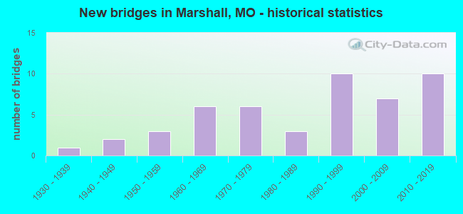
- New bridges - historical statistics
- 11930-1939
- 21940-1949
- 31950-1959
- 61960-1969
- 61970-1979
- 31980-1989
- 101990-1999
- 72000-2009
- 102010-2019
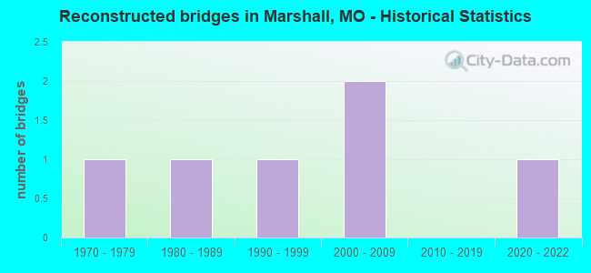
- Reconstructed bridges - Historical Statistics
- 11970-1979
- 11980-1989
- 11990-1999
- 22000-2009
- 02010-2019
- 12020-2022
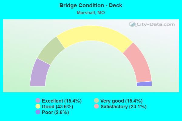
- Bridge Condition - Deck
- 15.4%Excellent
- 15.4%Very good
- 43.6%Good
- 23.1%Satisfactory
- 2.6%Poor
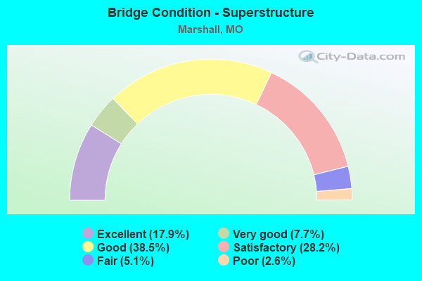
- Bridge Condition - Superstructure
- 17.9%Excellent
- 7.7%Very good
- 38.5%Good
- 28.2%Satisfactory
- 5.1%Fair
- 2.6%Poor
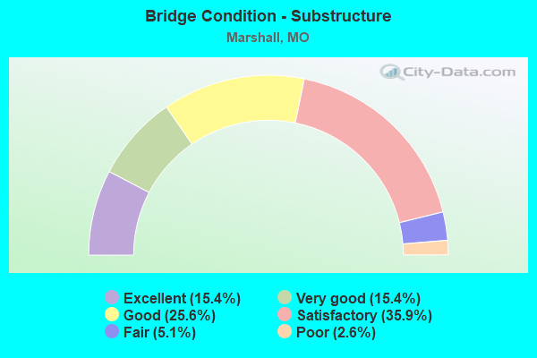
- Bridge Condition - Substructure
- 15.4%Excellent
- 15.4%Very good
- 25.6%Good
- 35.9%Satisfactory
- 5.1%Fair
- 2.6%Poor
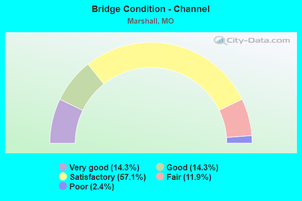
- Bridge Condition - Channel
- 14.3%Very good
- 14.3%Good
- 57.1%Satisfactory
- 11.9%Fair
- 2.4%Poor
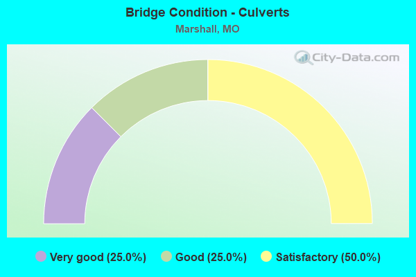
- Bridge Condition - Culverts
- 25.0%Very good
- 25.0%Good
- 50.0%Satisfactory
Find on map >> Show street view
Structure Number: 4566, Location: S 28 T 51 N R 21 W (Lat: 39.174639, Lng: -93.218722), Route carried "on" structure: State highway 41, Year Built: 1966, Year Reconstructed: 1984, Status: Open, Structure Length: 7.89m (25.89ft), Average Daily Traffic: 2,008 (year 2021), Truck Traffic: 21%, Average Future Daily Traffic: 2,610 (year 2041), Design Load: H 20, Features Intersected: SALT FORK CR
Minimum Vertical Clearance: 30+ m (98+ ft), Kilometerpoint: 23.620, Lanes on structure: 2, Base Highway Network: Yes, Owner: State Highway Agency, Approaching Roadway Width: 7.3m (24.0ft), Skew: 3 degrees, Material/Design: Steel continuous, Design/Construction: Stringer/Multi-beam, Number Of Spans In Main Unit: 3, Length of Maximum Span: 30.5m (100.1ft), Curb-To-Curb Width: 8.5m (27.9ft), Out-to-Out Width: 9.4m (30.8ft)
Condition: Deck: Satisfactory, Superstructure: Good, Substructure: Good, Channel: Satisfactory, Operating Rating: 67.5 metric tons, Method Used To Determine Operating Rating: Load Factor (LF), Inventory Rating: 40.5 metric tons, Method Used To Determine Inventory Rating: Load Factor (LF), Structural Evaluation: Better than present minimum criteria, Deck Geometry: Meets minimum limits, Waterway Adequacy: Equal to present desirable criteria, Approach Roadway Alignment: Equal to present desirable criteria, Designated Inspection Frequency: Every 24 months, Inspection Date: December 2021, Deck Structure Type: Concrete Cast-file-Place, Wearing Surface/Protective System: Wearing Surface: Other, Membrane: Built-up
Find on map >> Show street view
Structure Number: 4815, Location: S 36 T 51 N R 22 W (Lat: 39.163403, Lng: -93.279631), Route carried "on" structure: US 65, Year Built: 1967, Status: Open, Structure Length: 2.90m (9.51ft), Average Daily Traffic: 4,318 (year 2021), Truck Traffic: 23%, Average Future Daily Traffic: 7,557 (year 2041), Design Load: H 20, Features Intersected: STRADDLE CR
Minimum Vertical Clearance: 30+ m (98+ ft), Kilometerpoint: 185.133, Lanes on structure: 2, Base Highway Network: Yes, Owner: State Highway Agency, Approaching Roadway Width: 13.4m (44.0ft), Material/Design: Concrete continuous, Design/Construction: Slab, Number Of Spans In Main Unit: 3, Length of Maximum Span: 11.0m (36.1ft), Curb-To-Curb Width: 13.4m (44.0ft), Out-to-Out Width: 14.2m (46.6ft)
Condition: Deck: Satisfactory, Superstructure: Satisfactory, Substructure: Fair, Channel: Fair, Operating Rating: 48.6 metric tons, Method Used To Determine Operating Rating: Load Factor (LF), Inventory Rating: 28.8 metric tons, Method Used To Determine Inventory Rating: Load Factor (LF), Structural Evaluation: Somewhat better than minimum adequacy, Deck Geometry: Better than present minimum criteria, Waterway Adequacy: Equal to present desirable criteria, Approach Roadway Alignment: Equal to present minimum criteria, Designated Inspection Frequency: Every 24 months, Inspection Date: December 2021, Deck Structure Type: Concrete Cast-file-Place, Wearing Surface/Protective System: Wearing Surface: Epoxy Overlay, Deck Protection: Bituminous
Find on map >> Show street view
Structure Number: 6576, Location: S 21 T 50 N R 21 W (Lat: 39.095764, Lng: -93.220461), Route carried "on" structure: State highway YY, Year Built: 1956, Year Reconstructed: 2009, Status: Open, Structure Length: 3.75m (12.30ft), Average Daily Traffic: 1,463 (year 2021), Truck Traffic: 9%, Average Future Daily Traffic: 1,829 (year 2041), Design Load: H 15, Features Intersected: FINNEY CR
Minimum Vertical Clearance: 30+ m (98+ ft), Kilometerpoint: 0.991, Lanes on structure: 2, Owner: State Highway Agency, Approaching Roadway Width: 7.3m (24.0ft), Skew: 1 degrees, Material/Design: Steel, Design/Construction: Stringer/Multi-beam, Number Of Spans In Main Unit: 3, Length of Maximum Span: 13.2m (43.3ft), Curb-To-Curb Width: 7.3m (24.0ft), Out-to-Out Width: 8.1m (26.6ft)
Condition: Deck: Good, Superstructure: Satisfactory, Substructure: Satisfactory, Channel: Satisfactory, Operating Rating: 55.8 metric tons, Method Used To Determine Operating Rating: Load Factor (LF), Inventory Rating: 33.3 metric tons, Method Used To Determine Inventory Rating: Load Factor (LF), Structural Evaluation: Equal to present minimum criteria, Deck Geometry: Meets minimum limits, Waterway Adequacy: Equal to present desirable criteria, Approach Roadway Alignment: Equal to present minimum criteria, Designated Inspection Frequency: Every 24 months, Inspection Date: December 2021, Deck Structure Type: Concrete Cast-file-Place, Wearing Surface/Protective System: Wearing Surface: Monolithic Concrete, Deck Protection: Epoxy Coated Reinforcing
Find on map >> Show street view
Structure Number: 7354, Location: S 24 T 50 N R 21 W (Lat: 39.100756, Lng: -93.168225), Route carried "on" structure: State highway WW, Year Built: 1960, Status: Open, Structure Length: 0.77m (2.53ft), Average Daily Traffic: 559 (year 2021), Truck Traffic: 4%, Average Future Daily Traffic: 699 (year 2041), Design Load: H 15, Features Intersected: SALT FORK CR
Minimum Vertical Clearance: 30+ m (98+ ft), Kilometerpoint: 2.694, Lanes on structure: 2, Owner: State Highway Agency, Approaching Roadway Width: 7.3m (24.0ft), Skew: 1 degrees, Material/Design: Concrete continuous, Design/Construction: Culvert, Number Of Spans In Main Unit: 2, Length of Maximum Span: 3.7m (12.1ft)
Condition: Channel: Satisfactory, Culverts: Satisfactory, Operating Rating: 54.0 metric tons, Method Used To Determine Operating Rating: Field evaluation and documented engineering judgment, Inventory Rating: 32.4 metric tons, Method Used To Determine Inventory Rating: Field evaluation and documented engineering judgment, Structural Evaluation: Equal to present minimum criteria, Waterway Adequacy: Better than present minimum criteria, Approach Roadway Alignment: Meets minimum limits, Designated Inspection Frequency: Every 24 months, Inspection Date: December 2021
Find on map >> Show street view
Structure Number: 779, Location: S 16 T 50 N R 21 W (Lat: 39.121861, Lng: -93.214653), Route carried "on" structure: US 65, Year Built: 1962, Status: Open, Structure Length: 4.30m (14.11ft), Average Daily Traffic: 6,364 (year 2021), Truck Traffic: 20%, Average Future Daily Traffic: 8,273 (year 2041), Design Load: H 20, Features Intersected: KCS RR
Minimum Vertical Clearance: 30+ m (98+ ft), Kilometerpoint: 192.623, Lanes on structure: 2, Base Highway Network: Yes, Owner: State Highway Agency, Approaching Roadway Width: 13.4m (44.0ft), Material/Design: Steel continuous, Design/Construction: Stringer/Multi-beam, Number Of Spans In Main Unit: 3, Length of Maximum Span: 15.8m (51.8ft), Curb or Sidewalk Widths: Left: 0.2m (0.7ft), Right: 0.2m (0.7ft), Curb-To-Curb Width: 8.8m (28.9ft), Out-to-Out Width: 9.6m (31.5ft)
Condition: Deck: Satisfactory, Superstructure: Fair, Substructure: Fair, Operating Rating: 38.7 metric tons, Method Used To Determine Operating Rating: Load Factor (LF), Inventory Rating: 23.4 metric tons, Method Used To Determine Inventory Rating: Load Factor (LF), Structural Evaluation: Somewhat better than minimum adequacy, Deck Geometry: High priority of replacement, Underclear: Superior to present desirable criteria, Approach Roadway Alignment: Equal to present minimum criteria, Length Of Structure Improvement: 0.53m (1.74ft), Designated Inspection Frequency: Every 24 months, Inspection Date: December 2021, Bridge Improvement Cost: $497,000, Roadway Improvement Cost: $50,000, Total Project Cost: $745,000 ( Estimate for 2022), Deck Structure Type: Concrete Cast-file-Place, Wearing Surface/Protective System: Wearing Surface: Low Slump Concrete
Find on map >> Show street view
Structure Number: 2474, Location: S 11 T 50 N R 21 W (Lat: 39.133250, Lng: -93.191056), Route carried "under" structure: State highway O, Year Built: 1973, Structure Length: 0. m, Average Daily Traffic: 664 (year 2021), Truck Traffic: 3%, Features Intersected: RT O
Minimum Vertical Clearance: 7.67m (25.16ft), Kilometerpoint: 29.417, Lanes on structure: 2, Lanes under structure: 2, Material/Design: Steel continuous, Design/Construction: Stringer/Multi-beam, Length of Maximum Span: 25.9m (85.0ft)