Bridge Statistics for Marshalltown, Iowa (IA)
Condition, Traffic, Stress, Structural Evaluation, Project Costs
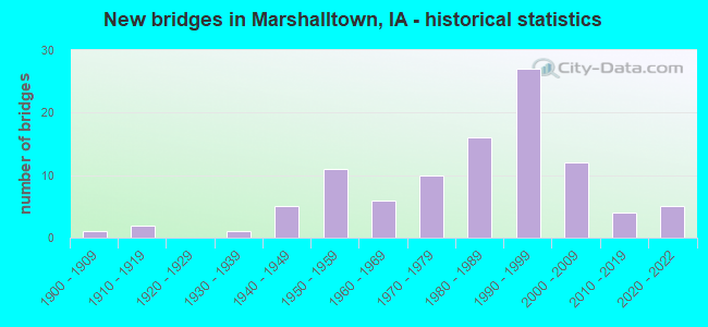
- New bridges - historical statistics
- 11900-1909
- 21910-1919
- 11930-1939
- 51940-1949
- 111950-1959
- 61960-1969
- 101970-1979
- 161980-1989
- 271990-1999
- 122000-2009
- 42010-2019
- 52020-2022
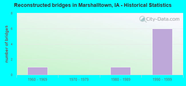
- Reconstructed bridges - Historical Statistics
- 11960-1969
- 01970-1979
- 11980-1989
- 61990-1999
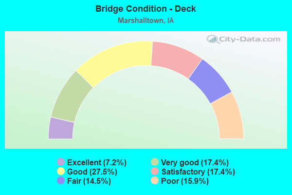
- Bridge Condition - Deck
- 7.2%Excellent
- 17.4%Very good
- 27.5%Good
- 17.4%Satisfactory
- 14.5%Fair
- 15.9%Poor
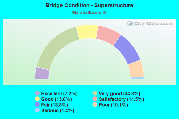
- Bridge Condition - Superstructure
- 7.2%Excellent
- 34.8%Very good
- 13.0%Good
- 14.5%Satisfactory
- 18.8%Fair
- 10.1%Poor
- 1.4%Serious
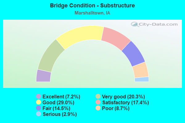
- Bridge Condition - Substructure
- 7.2%Excellent
- 20.3%Very good
- 29.0%Good
- 17.4%Satisfactory
- 14.5%Fair
- 8.7%Poor
- 2.9%Serious
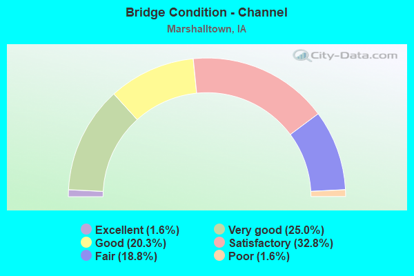
- Bridge Condition - Channel
- 1.6%Excellent
- 25.0%Very good
- 20.3%Good
- 32.8%Satisfactory
- 18.8%Fair
- 1.6%Poor
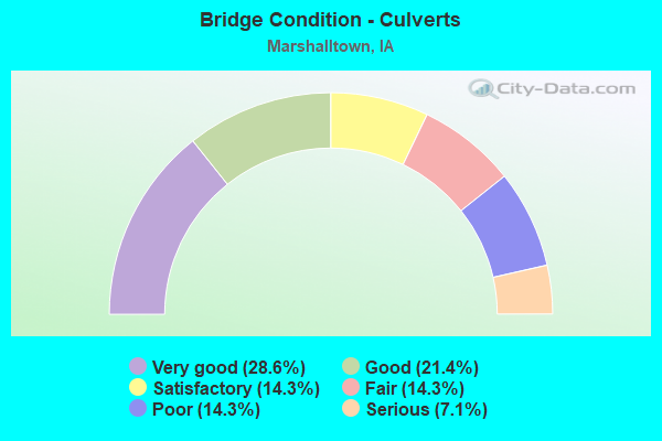
- Bridge Condition - Culverts
- 28.6%Very good
- 21.4%Good
- 14.3%Satisfactory
- 14.3%Fair
- 14.3%Poor
- 7.1%Serious
Find on map >> Show street view
Structure Number: 608295, Location: 1.0 MILE W OF JCT SR T31 (Lat: 42.006953, Lng: -92.842958), Route carried "on" structure: US 30, Year Built: 2001, Status: Open, Structure Length: 5.46m (17.91ft), Average Daily Traffic: 5,800 (year 2020), Truck Traffic: 12%, Average Future Daily Traffic: 5,800 (year 2042), Design Load: HS 20, Features Intersected: UP RR
Minimum Vertical Clearance: 30+ m (98+ ft), Kilometerpoint: 229.517, Lanes on structure: 2, Owner: State Highway Agency, Approaching Roadway Width: 14.6m (47.9ft), Skew: 2 degrees, Material/Design: Prestressed concrete, Design/Construction: Stringer/Multi-beam, Number Of Spans In Main Unit: 3, Length of Maximum Span: 20.4m (66.9ft), Curb-To-Curb Width: 12.0m (39.4ft), Out-to-Out Width: 13.0m (42.7ft)
Condition: Deck: Very good, Superstructure: Very good, Substructure: Good, Operating Rating: 67.7 metric tons, Method Used To Determine Operating Rating: Load Factor (LF), Inventory Rating: 40.6 metric tons, Method Used To Determine Inventory Rating: Load Factor (LF), Structural Evaluation: Better than present minimum criteria, Deck Geometry: Better than present minimum criteria, Underclear: Superior to present desirable criteria, Approach Roadway Alignment: Equal to present desirable criteria, Designated Inspection Frequency: Every 24 months, Inspection Date: Febuary 2022, Deck Structure Type: Concrete Cast-file-Place, Wearing Surface/Protective System: Wearing Surface: Monolithic Concrete, Deck Protection: Epoxy Coated Reinforcing
Find on map >> Show street view
Structure Number: 608735, Location: AT JUNCTION WITH US 30 (Lat: 42.007847, Lng: -93.020342), Route carried "on" structure: State highway 330, Year Built: 2001, Status: Open, Structure Length: 8.38m (27.49ft), Average Daily Traffic: 3,450 (year 2020), Truck Traffic: 12%, Average Future Daily Traffic: 3,450 (year 2040), Design Load: HS 20, Features Intersected: US 30
Minimum Vertical Clearance: 30+ m (98+ ft), Kilometerpoint: 55.891, Lanes on structure: 2, Lanes under structure: 4, Base Highway Network: Yes, Owner: State Highway Agency, Approaching Roadway Width: 14.6m (47.9ft), Skew: 3 degrees, Material/Design: Prestressed concrete, Design/Construction: Stringer/Multi-beam, Number Of Spans In Main Unit: 2, Length of Maximum Span: 42.7m (140.1ft), Curb-To-Curb Width: 12.0m (39.4ft), Out-to-Out Width: 13.0m (42.7ft)
Condition: Deck: Good, Superstructure: Very good, Substructure: Good, Operating Rating: 85.3 metric tons, Method Used To Determine Operating Rating: Load Factor (LF), Inventory Rating: 48.0 metric tons, Method Used To Determine Inventory Rating: Load Factor (LF), Structural Evaluation: Better than present minimum criteria, Deck Geometry: Better than present minimum criteria, Underclear: Equal to present minimum criteria, Approach Roadway Alignment: Better than present minimum criteria, Designated Inspection Frequency: Every 24 months, Inspection Date: April 2020, Deck Structure Type: Concrete Cast-file-Place, Wearing Surface/Protective System: Wearing Surface: Monolithic Concrete, Deck Protection: Epoxy Coated Reinforcing
Find on map >> Show street view
Structure Number: 699776, Location: IOWA VETERANS HOME (Lat: 42.054708, Lng: -92.930819), Route carried "on" structure: State lands road , Year Built: 1995, Status: Open, Structure Length: 0.98m (3.22ft), Design Load: HS 20, Features Intersected: BRADDY CREEK, Facility Carried by Structure: MEMORIAL DR
Minimum Vertical Clearance: 30+ m (98+ ft), Kilometerpoint: 0.172, Lanes on structure: 2, Owner: State Agenciy, Approaching Roadway Width: 6.1m (20.0ft), Material/Design: Concrete continuous, Design/Construction: Slab, Number Of Spans In Main Unit: 1, Length of Maximum Span: 7.6m (24.9ft), Curb-To-Curb Width: 6.1m (20.0ft), Out-to-Out Width: 6.9m (22.6ft)
Condition: Deck: Very good, Superstructure: Very good, Substructure: Very good, Channel: Excellent, Operating Rating: 70.7 metric tons, Method Used To Determine Operating Rating: Load Factor (LF), Inventory Rating: 41.7 metric tons, Method Used To Determine Inventory Rating: Load Factor (LF), Structural Evaluation: Equal to present desirable criteria, Deck Geometry: Somewhat better than minimum adequacy, Waterway Adequacy: Equal to present desirable criteria, Approach Roadway Alignment: Equal to present desirable criteria, Designated Inspection Frequency: Every 24 months, Inspection Date: November 2020, Deck Structure Type: Concrete Cast-file-Place, Wearing Surface/Protective System: Wearing Surface: Monolithic Concrete, Deck Protection: Epoxy Coated Reinforcing
Find on map >> Show street view
Structure Number: 7911, Location: IN MARSHALLTOWN (Lat: 42.041653, Lng: -92.907947), Route carried "under" structure: City street , Year Built: 1985, Structure Length: 0. m, Average Daily Traffic: 5,400 (year 2017), Features Intersected: UP RR, MADISON&MARKET ST, Facility Carried by Structure: IA 14
Minimum Vertical Clearance: 30+ m (98+ ft), Kilometerpoint: 0.386, Lanes on structure: 4, Lanes under structure: 4, Material/Design: Prestressed concrete, Design/Construction: Stringer/Multi-beam, Length of Maximum Span: 29.3m (96.1ft)
Find on map >> Show street view
Structure Number: 3541, Location: 084183504 (Lat: 42.040642, Lng: -92.912825), Route carried "under" structure: City street , Year Built: 1951, Structure Length: 0. m, Average Daily Traffic: 7,200 (year 2017), Features Intersected: RR AND MADISON ST, Facility Carried by Structure: SO CENTER ST
Minimum Vertical Clearance: 30+ m (98+ ft), Kilometerpoint: 1.204, Lanes on structure: 3, Lanes under structure: 4, Material/Design: Steel continuous, Design/Construction: Stringer/Multi-beam, Length of Maximum Span: 34.4m (112.9ft)
Find on map >> Show street view
Structure Number: 3541, Location: 084183504 (Lat: 42.040642, Lng: -92.912825), Route carried "under" structure: City street , Year Built: 1951, Structure Length: 0. m, Average Daily Traffic: 1,300 (year 1975), Features Intersected: RR AND MADISON ST, Facility Carried by Structure: SO CENTER ST
Minimum Vertical Clearance: 30+ m (98+ ft), Kilometerpoint: 1.576, Lanes on structure: 3, Lanes under structure: 4, Material/Design: Steel continuous, Design/Construction: Stringer/Multi-beam, Length of Maximum Span: 34.4m (112.9ft)
Find on map >> Show street view
Structure Number: 3541, Location: 084183504 (Lat: 42.040642, Lng: -92.912825), Route carried "under" structure: City street , Year Built: 1951, Structure Length: 0. m, Average Daily Traffic: 1,370 (year 1998), Features Intersected: RR AND MADISON ST, Facility Carried by Structure: SO CENTER ST
Minimum Vertical Clearance: 30+ m (98+ ft), Kilometerpoint: 1.650, Lanes on structure: 3, Lanes under structure: 4, Material/Design: Steel continuous, Design/Construction: Stringer/Multi-beam, Length of Maximum Span: 34.4m (112.9ft)
Find on map >> Show street view
Structure Number: 35651, Location: AT JUNCTION US 30 (Lat: 42.008475, Lng: -93.020183), Route carried "under" structure: US 30, Year Built: 2006, Structure Length: 0. m, Average Daily Traffic: 2,360 (year 2020), Truck Traffic: 21%, Features Intersected: US 30
Minimum Vertical Clearance: 30+ m (98+ ft), Kilometerpoint: 287.931, Lanes on structure: 2, Lanes under structure: 4, Material/Design: Prestressed concrete, Design/Construction: Stringer/Multi-beam, Length of Maximum Span: 39.9m (130.9ft)
Find on map >> Show street view
Structure Number: 5038, Location: 084183500 (Lat: 42.039425, Lng: -92.919736), Route carried "under" structure: City street , Year Built: 1984, Structure Length: 0. m, Average Daily Traffic: 600 (year 1975), Features Intersected: UP RR & ST, Facility Carried by Structure: S 3RD ST
Minimum Vertical Clearance: 30+ m (98+ ft), Kilometerpoint: 1.144, Lanes on structure: 4, Lanes under structure: 4, Material/Design: Prestressed concrete, Design/Construction: Stringer/Multi-beam, Length of Maximum Span: 29.6m (97.1ft)
Find on map >> Show street view
Structure Number: 6015, Location: 1.1 MI. E OF JCT. IA 330 (Lat: 42.007261, Lng: -92.999861), Route carried "under" structure: US 30, Year Built: 1995, Structure Length: 0. m, Average Daily Traffic: 10,500 (year 2020), Truck Traffic: 18%, Features Intersected: US 30, Facility Carried by Structure: MARSH AVE
Minimum Vertical Clearance: 30+ m (98+ ft), Kilometerpoint: 289.656, Lanes on structure: 2, Lanes under structure: 4, Material/Design: Prestressed concrete, Design/Construction: Stringer/Multi-beam, Length of Maximum Span: 29.6m (97.1ft)
Find on map >> Show street view
Structure Number: 601615, Location: AT JUNCTION WITH IA 14 (Lat: 42.003703, Lng: -92.912897), Route carried "under" structure: State highway 14, Year Built: 1995, Structure Length: 0. m, Average Daily Traffic: 4,350 (year 2020), Truck Traffic: 4%, Features Intersected: IA 14, Facility Carried by Structure: EB US 30
Minimum Vertical Clearance: 30+ m (98+ ft), Kilometerpoint: 159.159, Lanes on structure: 2, Lanes under structure: 5, Material/Design: Steel continuous, Design/Construction: Stringer/Multi-beam, Length of Maximum Span: 39.0m (128.0ft)
Find on map >> Show street view
Structure Number: 60162, Location: AT THE JCT. OF IA 14 (Lat: 42.003922, Lng: -92.911889), Route carried "under" structure: State highway 14, Year Built: 1995, Structure Length: 0. m, Average Daily Traffic: 4,350 (year 2020), Truck Traffic: 4%, Features Intersected: IA 14, Facility Carried by Structure: WB US 30
Minimum Vertical Clearance: 30+ m (98+ ft), Kilometerpoint: 159.185, Lanes on structure: 2, Lanes under structure: 4, Material/Design: Steel continuous, Design/Construction: Stringer/Multi-beam, Length of Maximum Span: 39.0m (128.0ft)
Find on map >> Show street view
Structure Number: 60188, Location: 2.5 MILES W OF JCT IA 14 (Lat: 42.003264, Lng: -92.961467), Route carried "under" structure: County highway , Year Built: 1996, Structure Length: 0. m, Average Daily Traffic: 195 (year 2021), Features Intersected: OAKS AVE, Facility Carried by Structure: US 30 EB
Minimum Vertical Clearance: 30+ m (98+ ft), Kilometerpoint: 15.173, Lanes on structure: 2, Lanes under structure: 2, Material/Design: Prestressed concrete, Design/Construction: Stringer/Multi-beam, Length of Maximum Span: 29.6m (97.1ft)
Find on map >> Show street view
Structure Number: 601885, Location: 2.5 MILES W OF JCT IA 14 (Lat: 42.003528, Lng: -92.960797), Route carried "under" structure: County highway , Year Built: 1996, Structure Length: 0. m, Average Daily Traffic: 195 (year 2021), Features Intersected: OAKS AVE, Facility Carried by Structure: US 30 WB
Minimum Vertical Clearance: 30+ m (98+ ft), Kilometerpoint: 15.202, Lanes on structure: 2, Lanes under structure: 2, Material/Design: Prestressed concrete, Design/Construction: Stringer/Multi-beam, Length of Maximum Span: 29.3m (96.1ft)
Find on map >> Show street view
Structure Number: 60189, Location: 2.2 MILES E OF JCT IA 330 (Lat: 42.005692, Lng: -92.978719), Route carried "under" structure: County highway , Year Built: 1996, Structure Length: 0. m, Average Daily Traffic: 750 (year 2021), Features Intersected: RAMP B TO IA AVE, Facility Carried by Structure: US 30 EB
Minimum Vertical Clearance: 30+ m (98+ ft), Kilometerpoint: 0.787, Lanes on structure: 2, Lanes under structure: 1, Material/Design: Prestressed concrete, Design/Construction: Stringer/Multi-beam, Length of Maximum Span: 32.6m (107.0ft)
Find on map >> Show street view
Structure Number: 601895, Location: 2.1 MI. E OF JCT. IA 330 (Lat: 42.005700, Lng: -92.977789), Route carried "under" structure: County highway , Year Built: 1996, Structure Length: 0. m, Average Daily Traffic: 750 (year 2021), Features Intersected: RAMP B TO IA AVE, Facility Carried by Structure: US 30 WB
Minimum Vertical Clearance: 30+ m (98+ ft), Kilometerpoint: 0.826, Lanes on structure: 2, Lanes under structure: 1, Material/Design: Prestressed concrete, Design/Construction: Stringer/Multi-beam, Length of Maximum Span: 32.6m (107.0ft)
Find on map >> Show street view
Structure Number: 6019, Location: 1.5 MILES W OF JCT. IA 14 (Lat: 42.003047, Lng: -92.941256), Route carried "under" structure: US 30, Year Built: 1996, Structure Length: 0. m, Average Daily Traffic: 8,100 (year 2020), Truck Traffic: 22%, Features Intersected: US 30, Facility Carried by Structure: PARKER AVE
Minimum Vertical Clearance: 30+ m (98+ ft), Kilometerpoint: 294.578, Lanes on structure: 2, Lanes under structure: 4, Material/Design: Prestressed concrete, Design/Construction: Stringer/Multi-beam, Length of Maximum Span: 29.3m (96.1ft)
Find on map >> Show street view
Structure Number: 601905, Location: 1.0 MI. E OF JCT. IA 14 (Lat: 42.002828, Lng: -92.893131), Route carried "under" structure: US 30, Year Built: 1995, Structure Length: 0. m, Average Daily Traffic: 9,300 (year 2020), Truck Traffic: 19%, Features Intersected: RELOC US 30, Facility Carried by Structure: GOVERNOR RD
Minimum Vertical Clearance: 30+ m (98+ ft), Kilometerpoint: 298.562, Lanes on structure: 2, Lanes under structure: 4, Material/Design: Prestressed concrete, Design/Construction: Stringer/Multi-beam, Length of Maximum Span: 29.6m (97.1ft)
Find on map >> Show street view
Structure Number: 60191, Location: 1.5 MILES E OF JCT IA 14 (Lat: 42.002556, Lng: -92.883678), Route carried "under" structure: US 30, Year Built: 1995, Structure Length: 0. m, Average Daily Traffic: 8,000 (year 2020), Truck Traffic: 17%, Features Intersected: US 30, Facility Carried by Structure: S 18TH AVE
Minimum Vertical Clearance: 30+ m (98+ ft), Kilometerpoint: 299.341, Lanes on structure: 4, Lanes under structure: 4, Material/Design: Prestressed concrete, Design/Construction: Stringer/Multi-beam, Length of Maximum Span: 29.6m (97.1ft)
Find on map >> Show street view
Structure Number: 608735, Location: AT JUNCTION WITH US 30 (Lat: 42.007847, Lng: -93.020342), Route carried "under" structure: US 30, Year Built: 2001, Structure Length: 0. m, Average Daily Traffic: 2,360 (year 2020), Truck Traffic: 21%, Features Intersected: US 30
Minimum Vertical Clearance: 30+ m (98+ ft), Kilometerpoint: 287.973, Lanes on structure: 2, Lanes under structure: 4, Material/Design: Prestressed concrete, Design/Construction: Stringer/Multi-beam, Length of Maximum Span: 42.7m (140.1ft)