Bridge Statistics for Martensdale, Iowa (IA)
Condition, Traffic, Stress, Structural Evaluation, Project Costs
- National Bridge Inventory (NBI) Statistics
- 11Number of bridges
- 144ft / 43.6mTotal length
- 9,320Total average daily traffic
- 943Total average daily truck traffic
- 9,320Total future (year 2038) average daily traffic
- National Bridge Inventory (NBI) Registered Bridges for Martensdale
- No street view available for this location
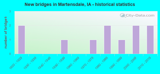
- New bridges - historical statistics
- 21920-1929
- 11950-1959
- 11970-1979
- 21980-1989
- 11990-1999
- 22000-2009
- 22010-2019

- Reconstructed bridges - Historical Statistics
- 11970-1979
- 11980-1989


- Bridge Condition - Deck
- 33.3%Very good
- 22.2%Good
- 44.4%Satisfactory

- Bridge Condition - Superstructure
- 33.3%Very good
- 55.6%Good
- 11.1%Fair

- Bridge Condition - Substructure
- 33.3%Very good
- 44.4%Good
- 22.2%Poor

- Bridge Condition - Channel
- 27.3%Very good
- 27.3%Good
- 27.3%Satisfactory
- 18.2%Fair

- Bridge Condition - Culverts
- 50.0%Very good
- 50.0%Fair
Find on map >> Show street view
Structure Number: 51041, Location: 0.5 MILE N OF JCT. IA 92 (Lat: 41.376825, Lng: -93.735086), Route carried "on" structure: State highway 28, Year Built: 1927, Year Reconstructed: 1983, Status: Open, Structure Length: 1.04m (3.41ft), Average Daily Traffic: 2,200 (year 2020), Truck Traffic: 9%, Average Future Daily Traffic: 2,200 (year 2041), Design Load: HS 20, Features Intersected: DRAINAGE DITCH
Minimum Vertical Clearance: 30+ m (98+ ft), Kilometerpoint: 0.792, Lanes on structure: 2, Base Highway Network: Yes, Owner: State Highway Agency, Approaching Roadway Width: 12.2m (40.0ft), Material/Design: Concrete, Design/Construction: Slab, Number Of Spans In Main Unit: 1, Length of Maximum Span: 9.8m (32.2ft), Curb-To-Curb Width: 12.2m (40.0ft), Out-to-Out Width: 13.2m (43.3ft)
Condition: Deck: Good, Superstructure: Good, Substructure: Good, Channel: Satisfactory, Operating Rating: 78.5 metric tons, Method Used To Determine Operating Rating: Load Factor (LF), Inventory Rating: 47.0 metric tons, Method Used To Determine Inventory Rating: Load Factor (LF), Structural Evaluation: Better than present minimum criteria, Deck Geometry: Equal to present minimum criteria, Waterway Adequacy: Better than present minimum criteria, Approach Roadway Alignment: Better than present minimum criteria, Designated Inspection Frequency: Every 24 months, Inspection Date: March 2021, Deck Structure Type: Concrete Cast-file-Place, Wearing Surface/Protective System: Wearing Surface: Monolithic Concrete, Deck Protection: Epoxy Coated Reinforcing
Find on map >> Show street view
Structure Number: 51111, Location: 0.3 MILE EAST OF IA 28 (Lat: 41.368567, Lng: -93.735697), Route carried "on" structure: State highway 92, Year Built: 1982, Status: Open, Structure Length: 7.96m (26.12ft), Average Daily Traffic: 3,750 (year 2020), Truck Traffic: 9%, Average Future Daily Traffic: 3,750 (year 2041), Design Load: HS 20, Features Intersected: MIDDLE RIVER
Minimum Vertical Clearance: 30+ m (98+ ft), Kilometerpoint: 193.496, Lanes on structure: 2, Base Highway Network: Yes, Owner: State Highway Agency, Approaching Roadway Width: 14.6m (47.9ft), Material/Design: Prestressed concrete, Design/Construction: Stringer/Multi-beam, Number Of Spans In Main Unit: 3, Length of Maximum Span: 29.3m (96.1ft), Curb-To-Curb Width: 12.2m (40.0ft), Out-to-Out Width: 13.2m (43.3ft)
Condition: Deck: Good, Superstructure: Good, Substructure: Good, Channel: Good, Operating Rating: 66.5 metric tons, Method Used To Determine Operating Rating: Allowable Stress (AS), Inventory Rating: 29.9 metric tons, Method Used To Determine Inventory Rating: Allowable Stress (AS), Structural Evaluation: Better than present minimum criteria, Deck Geometry: Equal to present minimum criteria, Waterway Adequacy: Equal to present minimum criteria, Approach Roadway Alignment: Equal to present desirable criteria, Designated Inspection Frequency: Every 24 months, Inspection Date: July 2021, Deck Structure Type: Concrete Cast-file-Place, Wearing Surface/Protective System: Wearing Surface: Monolithic Concrete, Deck Protection: Epoxy Coated Reinforcing
Find on map >> Show street view
Structure Number: 5112, Location: 1.9 MI. E OF IA. 28 (Lat: 41.366625, Lng: -93.704944), Route carried "on" structure: State highway 92, Year Built: 1928, Year Reconstructed: 1992, Status: Open, Structure Length: 0.64m (2.10ft), Average Daily Traffic: 2,770 (year 2020), Truck Traffic: 14%, Average Future Daily Traffic: 2,770 (year 2040), Design Load: H 20, Features Intersected: STREAM
Minimum Vertical Clearance: 30+ m (98+ ft), Kilometerpoint: 196.140, Lanes on structure: 2, Base Highway Network: Yes, Owner: State Highway Agency, Approaching Roadway Width: 11.0m (36.1ft), Material/Design: Concrete continuous, Design/Construction: Culvert, Number Of Spans In Main Unit: 2, Length of Maximum Span: 3.0m (9.8ft)
Condition: Channel: Fair, Culverts: Fair, Operating Rating: 24.5 metric tons, Method Used To Determine Operating Rating: Field evaluation and documented engineering judgment, Inventory Rating: 18.1 metric tons, Method Used To Determine Inventory Rating: Field evaluation and documented engineering judgment, Structural Evaluation: Somewhat better than minimum adequacy, Waterway Adequacy: Equal to present minimum criteria, Approach Roadway Alignment: Better than present minimum criteria, Designated Inspection Frequency: Every 24 months, Inspection Date: September 2020
Find on map >> Show street view
Structure Number: 334671, Location: 076250403 (Lat: 41.417969, Lng: -93.738217), Route carried "on" structure: County highway , Year Built: 2002, Status: Open, Structure Length: 0.64m (2.10ft), Average Daily Traffic: 40 (year 2012), Average Future Daily Traffic: 40 (year 2038), Design Load: HS 20, Features Intersected: BRANCH NORTH RIVER, Facility Carried by Structure: LOCAL
Minimum Vertical Clearance: 30+ m (98+ ft), Kilometerpoint: 0.377, Lanes on structure: 2, Owner: County Highway Agency, Approaching Roadway Width: 7.9m (25.9ft), Material/Design: Concrete continuous, Design/Construction: Culvert, Number Of Spans In Main Unit: 2, Length of Maximum Span: 3.0m (9.8ft)
Condition: Channel: Good, Culverts: Very good, Operating Rating: 44.1 metric tons, Method Used To Determine Operating Rating: Assigned rating based on Load Factor Design (LFD) reported in metric tons, Inventory Rating: 32.7 metric tons, Method Used To Determine Inventory Rating: Assigned rating based on Load Factor Design (LFD) reported in metric tons, Structural Evaluation: Equal to present desirable criteria, Waterway Adequacy: Equal to present desirable criteria, Approach Roadway Alignment: Equal to present minimum criteria, Length Of Structure Improvement: 2.20m (7.22ft), Designated Inspection Frequency: Every 48 months, Inspection Date: October 2018, Bridge Improvement Cost: $15,000, Roadway Improvement Cost: $2,000
Find on map >> Show street view
Structure Number: 334691, Location: 076250705 (Lat: 41.410344, Lng: -93.772097), Route carried "on" structure: County highway , Year Built: 2000, Status: Posted for load, Structure Length: 1.37m (4.49ft), Average Daily Traffic: 15 (year 2012), Average Future Daily Traffic: 15 (year 2040), Features Intersected: BRANCH NORTH RIVER, Facility Carried by Structure: GRIMES ST
Minimum Vertical Clearance: 30+ m (98+ ft), Kilometerpoint: 1.239, Lanes on structure: 2, Owner: County Highway Agency, Approaching Roadway Width: 6.1m (20.0ft), Material/Design: Steel, Design/Construction: Stringer/Multi-beam, Number Of Spans In Main Unit: 1, Length of Maximum Span: 13.4m (44.0ft), Curb-To-Curb Width: 5.4m (17.7ft), Out-to-Out Width: 5.4m (17.7ft)
Condition: Deck: Satisfactory, Superstructure: Good, Substructure: Poor, Channel: Fair, Operating Rating: 20.0 metric tons, Method Used To Determine Operating Rating: Allowable Stress (AS), Inventory Rating: 16.7 metric tons, Method Used To Determine Inventory Rating: Allowable Stress (AS), Structural Evaluation: Meets minimum limits, Deck Geometry: High priority of corrective action, Waterway Adequacy: Equal to present minimum criteria, Approach Roadway Alignment: Equal to present minimum criteria, Bridge Posting: Required (Relationship of Operating Rating to Maximum Legal Load: 10.0 - 19.9% below), Length Of Structure Improvement: 4.50m (14.76ft), Designated Inspection Frequency: Every 24 months, Inspection Date: October 2020, Bridge Improvement Cost: $15,000, Roadway Improvement Cost: $2,000, Deck Structure Type: Wood or Timber, Wearing Surface/Protective System: Wearing Surface: Gravel
Find on map >> Show street view
Structure Number: 33473, Location: 076251410 (Lat: 41.381231, Lng: -93.703806), Route carried "on" structure: County highway , Year Built: 1950, Status: Posted for load, Structure Length: 7.44m (24.41ft), Average Daily Traffic: 70 (year 2012), Average Future Daily Traffic: 70 (year 2040), Features Intersected: MIDDLE RIVER, Facility Carried by Structure: LOCAL
Minimum Vertical Clearance: 3.96m (12.99ft), Kilometerpoint: 5.713, Lanes on structure: 2, Owner: County Highway Agency, Approaching Roadway Width: 5.8m (19.0ft), Material/Design: Steel, Design/Construction: Truss - Thru, Number Of Spans In Main Unit: 1, Number Of Approach Spans: 2, Length of Maximum Span: 47.9m (157.2ft), Curb-To-Curb Width: 5.7m (18.7ft), Out-to-Out Width: 6.1m (20.0ft)
Condition: Deck: Satisfactory, Superstructure: Fair, Substructure: Poor, Channel: Satisfactory, Operating Rating: 16.9 metric tons, Method Used To Determine Operating Rating: Allowable Stress (AS), Inventory Rating: 11.6 metric tons, Method Used To Determine Inventory Rating: Allowable Stress (AS), Structural Evaluation: Meets minimum limits, Deck Geometry: High priority of replacement, Waterway Adequacy: Better than present minimum criteria, Approach Roadway Alignment: Equal to present minimum criteria, Bridge Posting: Required (Relationship of Operating Rating to Maximum Legal Load: > 39.9% below), Length Of Structure Improvement: 27.50m (90.22ft), Designated Inspection Frequency: Every 24 months, Critical Feature Inspection Frequency: Every 24 months, Inspection Date: October 2020, Critical Feature Inspection Date: August 2021, Bridge Improvement Cost: $743,000, Roadway Improvement Cost: $75,000, Deck Structure Type: Wood or Timber, Wearing Surface/Protective System: Wearing Surface: Wood or Timber
Find on map >> Show street view
Structure Number: 334751, Location: 076252303 (Lat: 41.381236, Lng: -93.700558), Route carried "on" structure: County highway , Year Built: 1999, Status: Open, Structure Length: 4.57m (14.99ft), Average Daily Traffic: 90 (year 2012), Truck Traffic: 9%, Average Future Daily Traffic: 90 (year 2040), Design Load: HS 20, Features Intersected: BRANCH MIDDLE RIVER, Facility Carried by Structure: LOCAL
Minimum Vertical Clearance: 30+ m (98+ ft), Kilometerpoint: 1.888, Lanes on structure: 2, Owner: County Highway Agency, Approaching Roadway Width: 7.3m (24.0ft), Material/Design: Concrete continuous, Design/Construction: Slab, Number Of Spans In Main Unit: 3, Length of Maximum Span: 18.0m (59.1ft), Curb-To-Curb Width: 7.5m (24.6ft), Out-to-Out Width: 10.1m (33.1ft)
Condition: Deck: Very good, Superstructure: Very good, Substructure: Very good, Channel: Very good, Operating Rating: 59.6 metric tons, Method Used To Determine Operating Rating: Load Factor (LF), Inventory Rating: 35.7 metric tons, Method Used To Determine Inventory Rating: Load Factor (LF), Structural Evaluation: Equal to present desirable criteria, Deck Geometry: Equal to present minimum criteria, Waterway Adequacy: Equal to present desirable criteria, Approach Roadway Alignment: Equal to present desirable criteria, Length Of Structure Improvement: 15.00m (49.21ft), Designated Inspection Frequency: Every 48 months, Inspection Date: October 2020, Bridge Improvement Cost: $15,000, Roadway Improvement Cost: $2,000, Deck Structure Type: Concrete Cast-file-Place, Wearing Surface/Protective System: Wearing Surface: Monolithic Concrete
Find on map >> Show street view
Structure Number: 334761, Location: 076252306 (Lat: 41.374869, Lng: -93.702731), Route carried "on" structure: County highway , Year Built: 2018, Status: Open, Structure Length: 2.53m (8.30ft), Average Daily Traffic: 60 (year 2012), Truck Traffic: 22%, Average Future Daily Traffic: 60 (year 2040), Design Load: HL 93, Features Intersected: BR MIDDLE RIVER, Facility Carried by Structure: 55TH AVE
Minimum Vertical Clearance: 30+ m (98+ ft), Kilometerpoint: 4.981, Lanes on structure: 2, Owner: County Highway Agency, Approaching Roadway Width: 8.5m (27.9ft), Skew: 1 degrees, Material/Design: Concrete continuous, Design/Construction: Slab, Number Of Spans In Main Unit: 1, Length of Maximum Span: 9.4m (30.8ft), Curb-To-Curb Width: 7.5m (24.6ft), Out-to-Out Width: 8.3m (27.2ft)
Condition: Deck: Very good, Superstructure: Very good, Substructure: Very good, Channel: Very good, Operating Rating: 42.1 metric tons, Method Used To Determine Operating Rating: Assigned ratings based on Load and Resistance Factor Design (LRFD) reported by rating factor (RF) using HL93 loadings, Inventory Rating: 32.4 metric tons, Method Used To Determine Inventory Rating: Assigned ratings based on Load and Resistance Factor Design (LRFD) reported by rating factor (RF) using HL93 loadings, Structural Evaluation: Equal to present desirable criteria, Deck Geometry: Equal to present minimum criteria, Waterway Adequacy: Equal to present desirable criteria, Approach Roadway Alignment: Equal to present desirable criteria, Designated Inspection Frequency: Every 24 months, Inspection Date: October 2020, Deck Structure Type: Concrete Cast-file-Place, Wearing Surface/Protective System: Wearing Surface: Monolithic Concrete
Find on map >> Show street view
Structure Number: 334781, Location: 076252802 (Lat: 41.362647, Lng: -93.751014), Route carried "on" structure: County highway , Year Built: 1971, Status: Posted for load-capacity, Structure Length: 6.89m (22.60ft), Average Daily Traffic: 180 (year 2016), Average Future Daily Traffic: 180 (year 2040), Features Intersected: MIDDLE RIVER, Facility Carried by Structure: FM
Minimum Vertical Clearance: 30+ m (98+ ft), Kilometerpoint: 9.608, Lanes on structure: 2, Owner: County Highway Agency, Approaching Roadway Width: 7.9m (25.9ft), Skew: 1 degrees, Material/Design: Steel continuous, Design/Construction: Stringer/Multi-beam, Number Of Spans In Main Unit: 3, Length of Maximum Span: 26.8m (87.9ft), Curb-To-Curb Width: 7.3m (24.0ft), Out-to-Out Width: 7.9m (25.9ft)
Condition: Deck: Satisfactory, Superstructure: Good, Substructure: Good, Channel: Satisfactory, Operating Rating: 34.0 metric tons, Method Used To Determine Operating Rating: Load Factor (LF), Inventory Rating: 20.4 metric tons, Method Used To Determine Inventory Rating: Load Factor (LF), Structural Evaluation: Somewhat better than minimum adequacy, Deck Geometry: Somewhat better than minimum adequacy, Waterway Adequacy: Better than present minimum criteria, Approach Roadway Alignment: Better than present minimum criteria, Bridge Posting: Required (Relationship of Operating Rating to Maximum Legal Load: 0.1 - 9.9% below), Length Of Structure Improvement: 22.60m (74.15ft), Designated Inspection Frequency: Every 24 months, Inspection Date: October 2020, Bridge Improvement Cost: $15,000, Roadway Improvement Cost: $2,000, Deck Structure Type: Concrete Cast-file-Place, Wearing Surface/Protective System: Wearing Surface: Monolithic Concrete
Find on map >> Show street view
Structure Number: 334801, Location: 076253206 (Lat: 41.349975, Lng: -93.755761), Route carried "on" structure: County highway , Year Built: 1985, Status: Open, Structure Length: 8.38m (27.49ft), Average Daily Traffic: 100 (year 2016), Average Future Daily Traffic: 100 (year 2039), Design Load: HS 20, Features Intersected: CLANTON CREEK, Facility Carried by Structure: FM
Minimum Vertical Clearance: 30+ m (98+ ft), Kilometerpoint: 1.429, Lanes on structure: 2, Owner: County Highway Agency, Approaching Roadway Width: 9.1m (29.9ft), Skew: 4 degrees, Material/Design: Prestressed concrete, Design/Construction: Stringer/Multi-beam, Number Of Spans In Main Unit: 3, Length of Maximum Span: 29.6m (97.1ft), Curb-To-Curb Width: 9.1m (29.9ft), Out-to-Out Width: 9.8m (32.2ft)
Condition: Deck: Satisfactory, Superstructure: Good, Substructure: Good, Channel: Good, Operating Rating: 70.3 metric tons, Method Used To Determine Operating Rating: Load Factor (LF), Inventory Rating: 42.1 metric tons, Method Used To Determine Inventory Rating: Load Factor (LF), Structural Evaluation: Better than present minimum criteria, Deck Geometry: Better than present minimum criteria, Waterway Adequacy: Equal to present desirable criteria, Approach Roadway Alignment: Equal to present desirable criteria, Length Of Structure Improvement: 27.50m (90.22ft), Designated Inspection Frequency: Every 48 months, Inspection Date: October 2019, Bridge Improvement Cost: $15,000, Roadway Improvement Cost: $2,000, Deck Structure Type: Concrete Cast-file-Place, Wearing Surface/Protective System: Wearing Surface: Monolithic Concrete
Find on map >> Show street view
Structure Number: 334831, Location: 076253303 (Lat: 41.344661, Lng: -93.747033), Route carried "on" structure: County highway , Year Built: 2019, Status: Open, Structure Length: 2.16m (7.09ft), Average Daily Traffic: 45 (year 2016), Average Future Daily Traffic: 45 (year 2041), Design Load: HL 93, Features Intersected: BR MIDDLE RIVER, Facility Carried by Structure: KIRKWOOD ST
Minimum Vertical Clearance: 30+ m (98+ ft), Kilometerpoint: 1.271, Lanes on structure: 2, Owner: County Highway Agency, Approaching Roadway Width: 9.1m (29.9ft), Material/Design: Concrete continuous, Design/Construction: Slab, Number Of Spans In Main Unit: 1, Number Of Approach Spans: 2, Length of Maximum Span: 8.5m (27.9ft), Curb-To-Curb Width: 7.5m (24.6ft), Out-to-Out Width: 8.3m (27.2ft)
Condition: Deck: Very good, Superstructure: Very good, Substructure: Very good, Channel: Very good, Operating Rating: 42.1 metric tons, Method Used To Determine Operating Rating: Assigned ratings based on Load and Resistance Factor Design (LRFD) reported by rating factor (RF) using HL93 loadings, Inventory Rating: 32.4 metric tons, Method Used To Determine Inventory Rating: Assigned ratings based on Load and Resistance Factor Design (LRFD) reported by rating factor (RF) using HL93 loadings, Structural Evaluation: Equal to present desirable criteria, Deck Geometry: Equal to present minimum criteria, Waterway Adequacy: Equal to present desirable criteria, Approach Roadway Alignment: Better than present minimum criteria, Designated Inspection Frequency: Every 24 months, Inspection Date: November 2021, Deck Structure Type: Concrete Cast-file-Place, Wearing Surface/Protective System: Wearing Surface: Monolithic Concrete, Membrane: Built-up, Deck Protection: Galvanized Reinforcing