Martensdale, Iowa
Submit your own pictures of this city and show them to the world
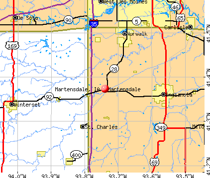
- OSM Map
- General Map
- Google Map
- MSN Map
Population change since 2000: -11.6%
 |
| Males: 197 | |
| Females: 216 |
| Median resident age: | 40.0 years |
| Iowa median age: | 38.9 years |
Zip codes: 50160.
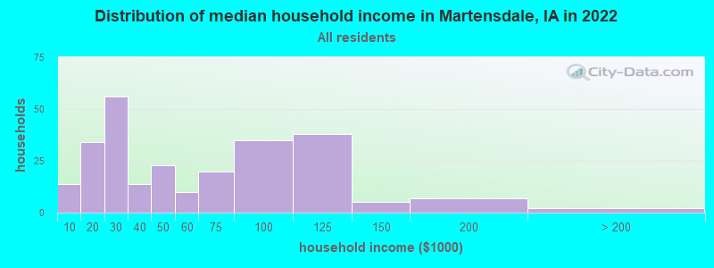
| Martensdale: | $46,134 |
| IA: | $69,588 |
Estimated per capita income in 2022: $27,599 (it was $16,638 in 2000)
Martensdale city income, earnings, and wages data
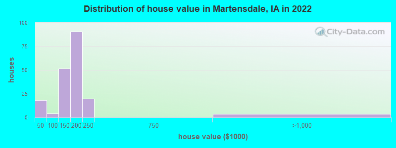
Estimated median house or condo value in 2022: $169,846 (it was $84,500 in 2000)
| Martensdale: | $169,846 |
| IA: | $194,600 |
Mean prices in 2022: all housing units: $169,888; detached houses: $169,504
Median gross rent in 2022: $795.
Detailed information about poverty and poor residents in Martensdale, IA
Compare current foreclosures near Martensdale, IA:
| Photo | Address | Area | Beds / Baths | Price | Details |
|---|---|---|---|---|---|

|
#1
41st St
Des Moines, IA 50310
|
878 sq. feet
|
1 baths 2 beds |
$209,900
|
show details |

|
#2
SW 13th St
Des Moines, IA 50315
|
620 sq. feet
|
1 baths 1 beds |
$154,900
|
show details |

|
#3
SE 8th St
Des Moines, IA 50315
|
1,008 sq. feet
|
1 baths 2 beds |
$234,900
|
show details |

|
#4
E Diehl Ave
Des Moines, IA 50320
|
1,796 sq. feet
|
4 baths 5 beds |
$339,900
|
show details |

|
#5
SW 5th St
Des Moines, IA 50315
|
730 sq. feet
|
1 baths 2 beds |
$169,900
|
show details |

|
#6
W Salem Ave
Indianola, IA 50125
|
- sq. feet
|
1 baths 3 beds |
$147,000
|
show details |

|
#7
S F St
Indianola, IA 50125
|
888 sq. feet
|
1 baths 3 beds |
show details | |

|
#8
E Jefferson St
Winterset, IA 50273
|
1,440 sq. feet
|
1 baths 3 beds |
show details | |

|
#9
Sunset Ter
Windsor Heights, IA 50324
|
1,120 sq. feet
|
2 baths 3 beds |
show details | |

|
#10
41st St
Des Moines, IA 50312
|
992 sq. feet
|
2 baths 2 beds |
show details |
| Photo | Address | Area | Beds / Baths | Price | Details |
|---|---|---|---|---|---|

|
#11
30th Ave
Norwalk, IA 50211
|
1,228 sq. feet
|
2 baths 4 beds |
show details | |

|
#12
E Elm St
Milo, IA 50166
|
1,008 sq. feet
|
2 baths 3 beds |
show details | |

|
#13
SW 7th St
Des Moines, IA 50315
|
856 sq. feet
|
1 baths 2 beds |
show details | |

|
#14
Fairfax St
Norwalk, IA 50211
|
1,288 sq. feet
|
3 baths 3 beds |
show details | |

|
#15
E Miller Ave
Des Moines, IA 50315
|
1,408 sq. feet
|
2 baths 3 beds |
show details | |

|
#16
34th Pl
West Des Moines, IA 50265
|
2,102 sq. feet
|
2 baths 3 beds |
show details | |

|
#17
Waveland Ct
Des Moines, IA 50312
|
2,012 sq. feet
|
1 baths 3 beds |
show details | |

|
#18
3rd St
West Des Moines, IA 50265
|
1,635 sq. feet
|
1 baths 3 beds |
show details | |

|
#19
Fleetwood Dr
Des Moines, IA 50315
|
1,500 sq. feet
|
1 baths 3 beds |
show details | |

|
#20
Casady Dr
Des Moines, IA 50315
|
1,603 sq. feet
|
1 baths 2 beds |
show details |
| Photo | Address | Area | Beds / Baths | Price | Details |
|---|---|---|---|---|---|

|
#21
Pennsylvania St
Carlisle, IA 50047
|
1,374 sq. feet
|
2 baths 4 beds |
show details | |

|
#22
Prospect Ave
West Des Moines, IA 50265
|
1,957 sq. feet
|
1 baths 3 beds |
show details | |

|
#23
335th St
Waukee, IA 50263
|
1,690 sq. feet
|
2 baths 4 beds |
show details | |

|
#24
E Porter Ave Unit 57
Des Moines, IA 50320
|
1,214 sq. feet
|
2 baths 3 beds |
show details | |

|
#25
SW 62nd St
Des Moines, IA 50312
|
976 sq. feet
|
1 baths 2 beds |
show details | |

|
#26
Boulder Ave
Des Moines, IA 50315
|
998 sq. feet
|
1 baths 2 beds |
show details | |

|
#27
E Thornton Ave
Des Moines, IA 50315
|
1,091 sq. feet
|
1 baths 2 beds |
show details | |

|
#28
6th St
West Des Moines, IA 50265
|
1,109 sq. feet
|
1 baths 3 beds |
show details | |

|
#29
7th St
West Des Moines, IA 50265
|
1,302 sq. feet
|
1 baths 4 beds |
show details | |

|
#30
Hart Ave Apt 1
Des Moines, IA 50320
|
1,321 sq. feet
|
2 baths 2 beds |
show details |
| Photo | Address | Area | Beds / Baths | Price | Details |
|---|---|---|---|---|---|

|
#31
Hart Ave Apt 5
Des Moines, IA 50320
|
1,106 sq. feet
|
2 baths 2 beds |
show details | |

|
#32
66th St Apt 14
Windsor Heights, IA 50324
|
943 sq. feet
|
2 baths 2 beds |
show details | |

|
#33
Kingman Blvd
Des Moines, IA 50311
|
1,294 sq. feet
|
1 baths 3 beds |
show details | |

|
#34
Iola Ave
Des Moines, IA 50312
|
1,270 sq. feet
|
1 baths 2 beds |
show details | |

|
#35
SE 7th St
Des Moines, IA 50315
|
960 sq. feet
|
1 baths 3 beds |
show details | |

|
#36
52nd St
West Des Moines, IA 50265
|
3,133 sq. feet
|
2 baths 4 beds |
show details | |

|
#37
Evergreen Ave
Des Moines, IA 50320
|
1,064 sq. feet
|
1 baths 3 beds |
show details | |

|
#38
SE 25th St
Des Moines, IA 50320
|
1,832 sq. feet
|
2 baths 4 beds |
show details | |

|
#39
33rd St
Des Moines, IA 50312
|
943 sq. feet
|
1 baths 2 beds |
show details | |

|
#40
41st St
Des Moines, IA 50312
|
1,741 sq. feet
|
2 baths 2 beds |
show details |
| Photo | Address | Area | Beds / Baths | Price | Details |
|---|---|---|---|---|---|

|
#41
41st St
Des Moines, IA 50312
|
1,368 sq. feet
|
1 baths 2 beds |
show details | |

|
#42
S 4th St
Carlisle, IA 50047
|
1,159 sq. feet
|
2 baths 3 beds |
show details | |

|
#43
67th St Unit 110
West Des Moines, IA 50266
|
999 sq. feet
|
1 baths 2 beds |
show details | |

|
#44
67th St Unit 414
West Des Moines, IA 50266
|
999 sq. feet
|
1 baths 2 beds |
show details | |

|
#45
E Gray St
Des Moines, IA 50315
|
840 sq. feet
|
1 baths 2 beds |
show details | |

|
#46
Virginia Cir
Des Moines, IA 50320
|
1,566 sq. feet
|
2 baths 3 beds |
show details | |

|
#47
Westown Pkwy Unit 20110
West Des Moines, IA 50266
|
1,215 sq. feet
|
1 baths 3 beds |
show details | |

|
#48
Woodland Ave Unit 207
West Des Moines, IA 50266
|
1,196 sq. feet
|
1 baths 2 beds |
show details | |

|
#49
Westown Pkwy Unit 21109
West Des Moines, IA 50266
|
1,215 sq. feet
|
1 baths 3 beds |
show details | |

|
Check over 1 million property listings on Foreclosure.com!
|
browse all offers | |||


- 54092.9%White alone
- 284.8%Two or more races
- 50.9%Hispanic
- 40.7%Black alone
- 10.2%American Indian alone
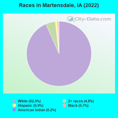
Races in Martensdale detailed stats: ancestries, foreign born residents, place of birth
According to our research of Iowa and other state lists, there were 2 registered sex offenders living in Martensdale, Iowa as of May 13, 2024.
The ratio of all residents to sex offenders in Martensdale is 228 to 1.
 Recent articles from our blog. Our writers, many of them Ph.D. graduates or candidates, create easy-to-read articles on a wide variety of topics.


Latest news from Martensdale, IA collected exclusively by city-data.com from local newspapers, TV, and radio stations
Ancestries: German (24.2%), English (20.8%), American (12.9%), Irish (7.1%), Danish (6.2%), Dutch (4.2%).
Current Local Time: CST time zone
Incorporated on 10/29/1920
Elevation: 850 feet
Land area: 0.38 square miles.
Population density: 1,093 people per square mile (low).

1 resident is foreign born
| This city: | 0.2% |
| Iowa: | 5.6% |
Median real estate property taxes paid for housing units with mortgages in 2022: $2,646 (1.4%)
Median real estate property taxes paid for housing units with no mortgage in 2022: $2,252 (1.6%)
Nearest city with pop. 50,000+: Des Moines, IA  (16.3 miles , pop. 198,682).
Nearest city with pop. 200,000+: Omaha, NE (118.4 miles , pop. 390,007).
Nearest city with pop. 1,000,000+: Chicago, IL (315.0 miles , pop. 2,896,016).
Nearest cities:
Latitude: 41.37 N, Longitude: 93.74 W
Area code: 641
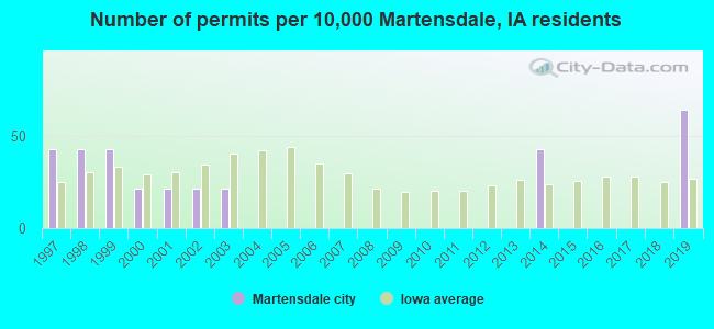
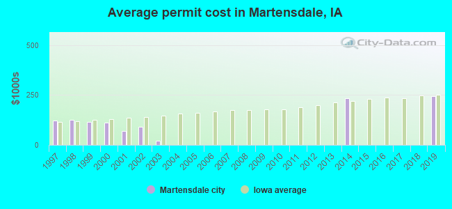
Single-family new house construction building permits:
- 2019: 3 buildings, average cost: $243,100
- 2014: 2 buildings, average cost: $235,400
- 2003: 1 building, cost: $20,400
- 2002: 1 building, cost: $90,000
- 2001: 1 building, cost: $70,000
- 2000: 1 building, cost: $110,000
- 1999: 2 buildings, average cost: $114,500
- 1998: 2 buildings, average cost: $126,800
- 1997: 2 buildings, average cost: $120,500
| Here: | 2.4% |
| Iowa: | 2.7% |
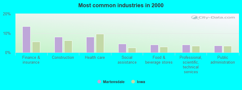
- Finance & insurance (13.5%)
- Construction (8.1%)
- Health care (8.1%)
- Social assistance (4.5%)
- Food & beverage stores (4.0%)
- Professional, scientific, technical services (4.0%)
- Public administration (3.6%)
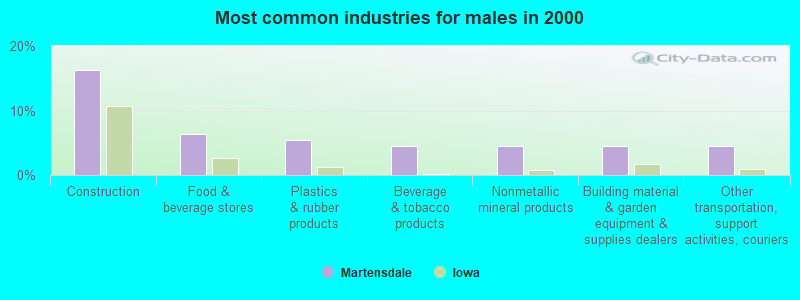
- Construction (16.2%)
- Food & beverage stores (6.3%)
- Plastics & rubber products (5.4%)
- Beverage & tobacco products (4.5%)
- Nonmetallic mineral products (4.5%)
- Building material & garden equipment & supplies dealers (4.5%)
- Other transportation, support activities, couriers (4.5%)
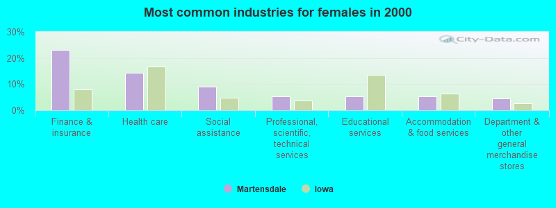
- Finance & insurance (23.2%)
- Health care (14.3%)
- Social assistance (8.9%)
- Professional, scientific, technical services (5.4%)
- Educational services (5.4%)
- Accommodation & food services (5.4%)
- Department & other general merchandise stores (4.5%)
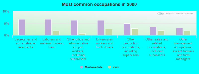
- Secretaries and administrative assistants (6.7%)
- Laborers and material movers, hand (6.7%)
- Other office and administrative support workers, including supervisors (6.3%)
- Driver/sales workers and truck drivers (6.3%)
- Other production occupations, including supervisors (4.9%)
- Other sales and related occupations, including supervisors (3.6%)
- Other management occupations, except farmers and farm managers (3.1%)

- Driver/sales workers and truck drivers (12.6%)
- Laborers and material movers, hand (11.7%)
- Other production occupations, including supervisors (8.1%)
- Vehicle and mobile equipment mechanics, installers, and repairers (6.3%)
- Other management occupations, except farmers and farm managers (5.4%)
- Religious workers (4.5%)
- Bus drivers (4.5%)
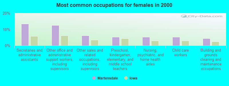
- Secretaries and administrative assistants (13.4%)
- Other office and administrative support workers, including supervisors (12.5%)
- Other sales and related occupations, including supervisors (6.2%)
- Preschool, kindergarten, elementary, and middle school teachers (5.4%)
- Nursing, psychiatric, and home health aides (5.4%)
- Child care workers (5.4%)
- Building and grounds cleaning and maintenance occupations (4.5%)
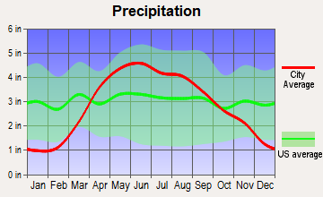
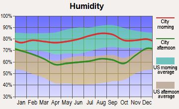
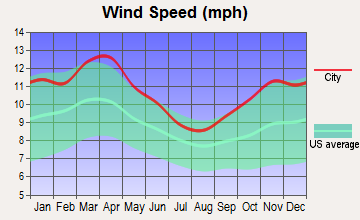
Average climate in Martensdale, Iowa
Based on data reported by over 4,000 weather stations
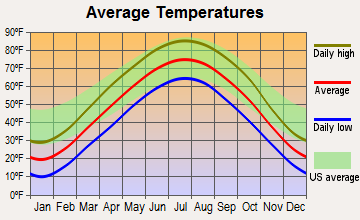
(lower is better)
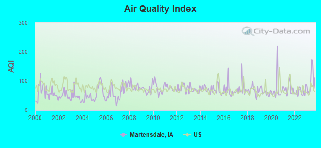
Air Quality Index (AQI) level in 2023 was 97.4. This is worse than average.
| City: | 97.4 |
| U.S.: | 72.6 |
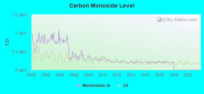
Carbon Monoxide (CO) [ppm] level in 2019 was 0.209. This is better than average. Closest monitor was 15.4 miles away from the city center.
| City: | 0.209 |
| U.S.: | 0.251 |
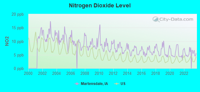
Nitrogen Dioxide (NO2) [ppb] level in 2023 was 5.78. This is about average. Closest monitor was 14.8 miles away from the city center.
| City: | 5.78 |
| U.S.: | 5.11 |
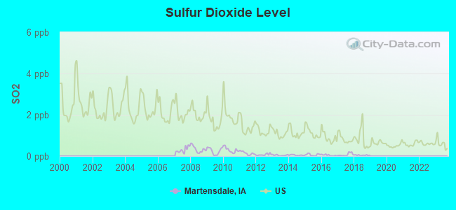
Sulfur Dioxide (SO2) [ppb] level in 2018 was 0.0417. This is significantly better than average. Closest monitor was 14.8 miles away from the city center.
| City: | 0.0417 |
| U.S.: | 1.5147 |
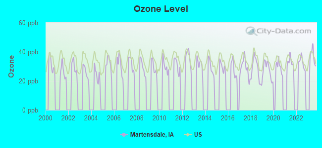
Ozone [ppb] level in 2023 was 36.8. This is about average. Closest monitor was 10.1 miles away from the city center.
| City: | 36.8 |
| U.S.: | 33.3 |
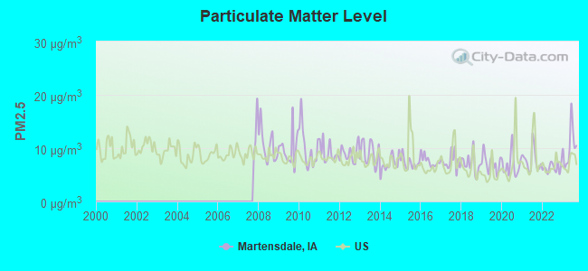
Particulate Matter (PM2.5) [µg/m3] level in 2023 was 10.3. This is worse than average. Closest monitor was 15.9 miles away from the city center.
| City: | 10.3 |
| U.S.: | 8.1 |
Tornado activity:
Martensdale-area historical tornado activity is near Iowa state average. It is 97% greater than the overall U.S. average.
On 6/18/1974, a category F4 (max. wind speeds 207-260 mph) tornado 14.9 miles away from the Martensdale city center killed 2 people and injured 50 people and caused between $5,000,000 and $50,000,000 in damages.
On 6/13/1976, a category F5 (max. wind speeds 261-318 mph) tornado 39.1 miles away from the city center injured 9 people and caused between $5,000,000 and $50,000,000 in damages.
Earthquake activity:
Martensdale-area historical earthquake activity is significantly above Iowa state average. It is 235% greater than the overall U.S. average.On 9/3/2016 at 12:02:44, a magnitude 5.8 (5.8 MW, Depth: 3.5 mi, Class: Moderate, Intensity: VI - VII) earthquake occurred 382.8 miles away from the city center
On 4/18/2008 at 09:36:59, a magnitude 5.4 (5.1 MB, 4.8 MS, 5.4 MW, 5.2 MW) earthquake occurred 370.4 miles away from Martensdale center
On 11/6/2011 at 03:53:10, a magnitude 5.7 (5.7 MW, Depth: 3.2 mi) earthquake occurred 435.9 miles away from Martensdale center
On 4/18/2008 at 09:36:59, a magnitude 5.2 (5.2 MW, Depth: 8.9 mi) earthquake occurred 370.4 miles away from Martensdale center
On 6/10/1987 at 23:48:54, a magnitude 5.1 (4.9 MB, 4.4 MS, 4.6 MS, 5.1 LG) earthquake occurred 356.4 miles away from the city center
On 9/26/1990 at 13:18:51, a magnitude 5.0 (4.7 MB, 4.8 LG, 5.0 LG, Depth: 7.7 mi) earthquake occurred 367.8 miles away from Martensdale center
Magnitude types: regional Lg-wave magnitude (LG), body-wave magnitude (MB), surface-wave magnitude (MS), moment magnitude (MW)
Natural disasters:
The number of natural disasters in Warren County (15) is near the US average (15).Major Disasters (Presidential) Declared: 13
Emergencies Declared: 1
Causes of natural disasters: Floods: 11, Storms: 11, Tornadoes: 6, Winds: 3, Hurricane: 1, Snow: 1, Winter Storm: 1, Other: 1 (Note: some incidents may be assigned to more than one category).

Hospitals and medical centers near Martensdale:
- NORWALK NURSING AND REHABILITATION CENTER (Nursing Home, about 8 miles away; NORWALK, IA)
- REGENCY CARE CENTER (Nursing Home, about 9 miles away; NORWALK, IA)
- THE VILLAGE (Nursing Home, about 9 miles away; INDIANOLA, IA)
- WARREN COUNTY HEALTH SERVICES (Home Health Center, about 10 miles away; INDIANOLA, IA)
- GOOD SAMARITAN SOCIETY - INDIANOLA (Nursing Home, about 10 miles away; INDIANOLA, IA)
- EASTON GROUP HOME (Hospital, about 11 miles away; INDIANOLA, IA)
- MANORCARE HEALTH SERVICES -WEST DES MOINES (Nursing Home, about 12 miles away; WEST DES MOINES, IA)
Colleges/universities with over 2000 students nearest to Martensdale:
- Drake University (about 17 miles; Des Moines, IA; Full-time enrollment: 3,768)
- Des Moines Area Community College (about 25 miles; Ankeny, IA; FT enrollment: 15,337)
- Iowa State University (about 46 miles; Ames, IA; FT enrollment: 28,662)
- Indian Hills Community College (about 74 miles; Ottumwa, IA; FT enrollment: 4,034)
- Iowa Central Community College (about 81 miles; Fort Dodge, IA; FT enrollment: 4,682)
- Northwest Missouri State University (about 93 miles; Maryville, MO; FT enrollment: 5,946)
- Truman State University (about 102 miles; Kirksville, MO; FT enrollment: 5,553)
Public high school in Martensdale:
- MARTENSDALE-ST MARYS JR-SR HIGH SCHOOL (Students: 230, Location: 390 BURLINGTON, Grades: 7-12)
Public elementary/middle school in Martensdale:
- MARTENSDALE ELEMENTARY SCHOOL (Students: 248, Location: 390 BURLINGTON, Grades: PK-6)
Points of interest:
Notable locations in Martensdale: Martensdale Fire and Rescue Department (A), Martensdale City Hall (B). Display/hide their locations on the map
Churches in Martensdale include: Martensdale Community Church (A), Saint Pauls Lutheran Church (B). Display/hide their locations on the map
| This city: | 2.5 people |
| Iowa: | 2.4 people |
| This city: | 62.4% |
| Whole state: | 64.7% |
| This city: | 10.8% |
| Whole state: | 6.7% |
Likely homosexual households (counted as self-reported same-sex unmarried-partner households)
- Lesbian couples: 0.0% of all households
- Gay men: 0.5% of all households
Banks with branches in Martensdale (2011 data):
- City State Bank: - Martensdale Office at 368 N Hwy 28, branch established on 2010/06/14. Info updated 2006/11/03: Bank assets: $236.0 mil, Deposits: $196.7 mil, headquarters in Norwalk, IA, positive income, Commercial Lending Specialization, 8 total offices, Holding Company: Albrecht Financial Services, Inc.
For population 15 years and over in Martensdale:
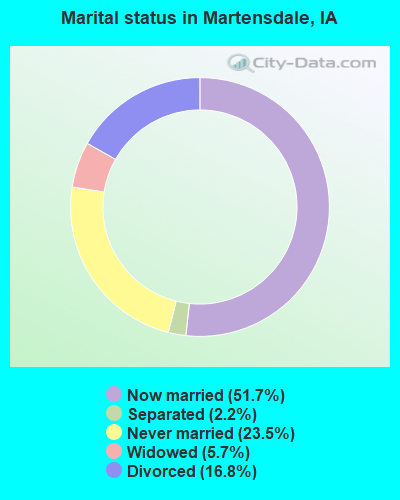
- Never married: 23.5%
- Now married: 51.7%
- Separated: 2.2%
- Widowed: 5.7%
- Divorced: 16.8%
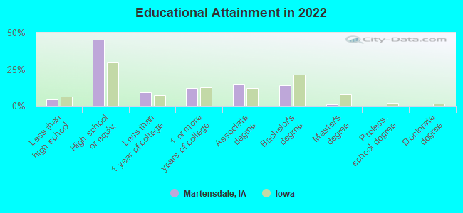
For population 25 years and over in Martensdale:
- High school or higher: 93.2%
- Bachelor's degree or higher: 13.9%
- Graduate or professional degree: 1.0%
- Unemployed: 2.6%
- Mean travel time to work (commute): 21.2 minutes
| Here: | 6.9 |
| Iowa average: | 10.5 |
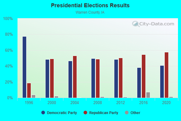
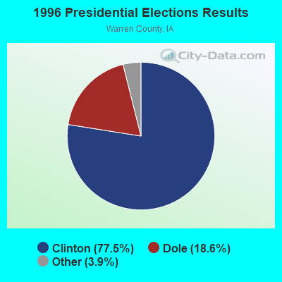
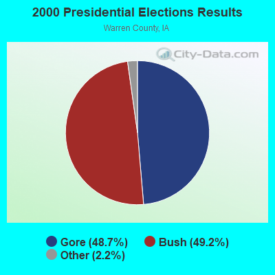
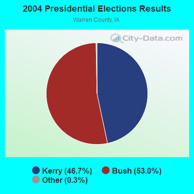
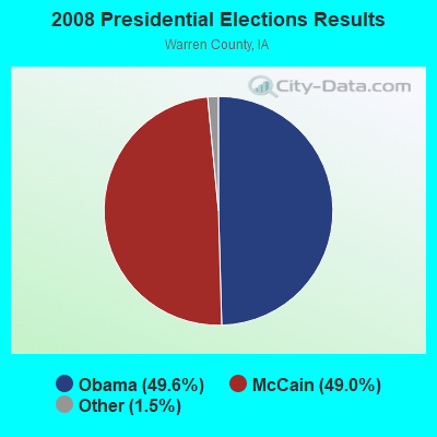

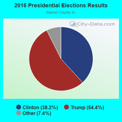
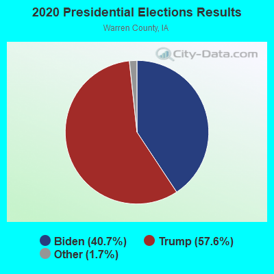
Graphs represent county-level data. Detailed 2008 Election Results
Religion statistics for Martensdale, IA (based on Warren County data)
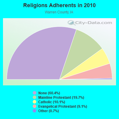
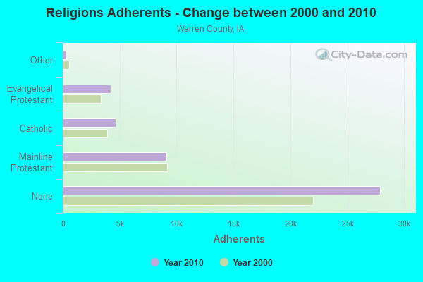
| Religion | Adherents | Congregations |
|---|---|---|
| Mainline Protestant | 9,123 | 29 |
| Catholic | 4,646 | 6 |
| Evangelical Protestant | 4,222 | 28 |
| Other | 331 | 3 |
| None | 27,903 | - |
Food Environment Statistics:
| Warren County: | 1.13 / 10,000 pop. |
| Iowa: | 2.14 / 10,000 pop. |
| This county: | 0.23 / 10,000 pop. |
| Iowa: | 0.23 / 10,000 pop. |
| Here: | 0.23 / 10,000 pop. |
| Iowa: | 0.43 / 10,000 pop. |
| This county: | 5.18 / 10,000 pop. |
| Iowa: | 5.55 / 10,000 pop. |
| Warren County: | 3.83 / 10,000 pop. |
| Iowa: | 8.01 / 10,000 pop. |
| This county: | 7.4% |
| State: | 7.8% |
| Warren County: | 30.6% |
| Iowa: | 27.3% |
| Warren County: | 14.0% |
| State: | 14.5% |
Health and Nutrition:
| Martensdale: | 49.9% |
| Iowa: | 49.5% |
| Martensdale: | 47.6% |
| Iowa: | 46.1% |
| Martensdale: | 29.1 |
| Iowa: | 28.6 |
| Martensdale: | 20.3% |
| Iowa: | 21.4% |
| Martensdale: | 8.5% |
| Iowa: | 10.4% |
| Martensdale: | 6.8 |
| Iowa: | 6.8 |
| Here: | 36.9% |
| State: | 33.8% |
| Martensdale: | 57.7% |
| Iowa: | 55.9% |
| This city: | 78.8% |
| State: | 77.7% |
More about Health and Nutrition of Martensdale, IA Residents
| Local government employment and payroll (March 2022) | |||||
| Function | Full-time employees | Monthly full-time payroll | Average yearly full-time wage | Part-time employees | Monthly part-time payroll |
|---|---|---|---|---|---|
| Financial Administration | 1 | $3,901 | $46,812 | 1 | $793 |
| Other Government Administration | 1 | $3,901 | $46,812 | 1 | $793 |
| Totals for Government | 2 | $7,803 | $46,818 | 2 | $1,585 |
Martensdale government finances - Expenditure in 2017 (per resident):
- Current Operations - Sewerage: $119,000 ($288.14)
Water Utilities: $109,000 ($263.92)
Regular Highways: $85,000 ($205.81)
General - Other: $43,000 ($104.12)
General Public Buildings: $16,000 ($38.74)
Health - Other: $15,000 ($36.32)
Financial Administration: $15,000 ($36.32)
Police Protection: $14,000 ($33.90)
Local Fire Protection: $11,000 ($26.63)
Central Staff Services: $3,000 ($7.26)
Protective Inspection and Regulation - Other: $2,000 ($4.84)
Judicial and Legal Services: $2,000 ($4.84)
Solid Waste Management: $1,000 ($2.42)
- General - Interest on Debt: $19,000 ($46.00)
- Intergovernmental to Local - Other - Police Protection: $14,000 ($33.90)
- Other Capital Outlay - Health - Other: $13,000 ($31.48)
- Total Salaries and Wages: $83,000 ($200.97)
Martensdale government finances - Revenue in 2017 (per resident):
- Charges - Sewerage: $164,000 ($397.09)
- Local Intergovernmental - Other: $77,000 ($186.44)
- Miscellaneous - General Revenue - Other: $4,000 ($9.69)
- Revenue - Water Utilities: $139,000 ($336.56)
- State Intergovernmental - Highways: $57,000 ($138.01)
- Tax - Property: $123,000 ($297.82)
General Sales and Gross Receipts: $52,000 ($125.91)
Public Utilities Sales: $5,000 ($12.11)
Other License: $2,000 ($4.84)
Martensdale government finances - Debt in 2017 (per resident):
- Long Term Debt - Beginning Outstanding - Unspecified Public Purpose: $345,000 ($835.35)
Outstanding Unspecified Public Purpose: $285,000 ($690.07)
Retired Unspecified Public Purpose: $58,000 ($140.44)
Martensdale government finances - Cash and Securities in 2017 (per resident):
- Other Funds - Cash and Securities: $696,000 ($1685.23)
Strongest AM radio stations in Martensdale:
- WHO (1040 AM; 50 kW; DES MOINES, IA; Owner: CITICASTERS LICENSES, L.P.)
- KPSZ (940 AM; 10 kW; DES MOINES, IA; Owner: SAGA COMMUNICATIONS OF IOWA, LLC)
- KWKY (1150 AM; 1 kW; DES MOINES, IA; Owner: PUTBRESE COMMUNICATIONS, LTD.)
- KBGG (1700 AM; 10 kW; DES MOINES, IA; Owner: CITADEL BROADCASTING COMPANY)
- KRNT (1350 AM; 5 kW; DES MOINES, IA; Owner: SAGA COMMUNICATIONS OF IOWA, LLC)
- KXLQ (1490 AM; 1 kW; INDIANOLA, IA; Owner: WARREN BROADCASTING, INC.)
- KXNO (1460 AM; 5 kW; DES MOINES, IA; Owner: CAPSTAR TX LIMITED PARTNERSHIP)
- WOI (640 AM; 5 kW; AMES, IA; Owner: IOWA STATE UNIV., OF SCIENCE & TECH.)
- KXEL (1540 AM; 50 kW; WATERLOO, IA; Owner: KXEL BROADCASTING COMPANY, INC.)
- KOIL (1020 AM; 50 kW; PLATTSMOUTH, NE; Owner: WAITT RADIO, INC.)
- KFAB (1110 AM; 50 kW; OMAHA, NE; Owner: CAPSTAR TX LIMITED PARTNERSHIP)
- KKAR (1290 AM; 50 kW; OMAHA, NE; Owner: WAITT RADIO, INC.)
- WHB (810 AM; 50 kW; KANSAS CITY, MO; Owner: UNION BROADCASTING, INC.)
Strongest FM radio stations in Martensdale:
- KIOA (93.3 FM; DES MOINES, IA; Owner: SAGA COMMUNICATIONS OF IOWA, LLC)
- KMXD (100.3 FM; DES MOINES, IA; Owner: CITICASTERS LICENSES, L.P.)
- KGGO (94.9 FM; DES MOINES, IA; Owner: CITADEL BROADCASTING COMPANY)
- WOI-FM (90.1 FM; AMES, IA; Owner: IOWA STATE UNIVERSITY OF SCI & TECH)
- KAZR (103.3 FM; PELLA, IA; Owner: SAGA COMMUNICATIONS OF IOWA, LLC)
- KSTZ (102.5 FM; DES MOINES, IA; Owner: SAGA COMMUNICATIONS OF IOWA, LLC)
- KZZQ (99.5 FM; WINTERSET, IA; Owner: POSITIVE IMPACT MEDIA, INC.)
- KJMC (89.3 FM; DES MOINES, IA; Owner: MINORITY COMMUNICATIONS, INC.)
- KJJY (92.5 FM; WEST DES MOINES, IA; Owner: CITADEL BROADCASTING COMPANY)
- KJJC (107.1 FM; OSCEOLA, IA; Owner: THOMAS H. BURKE, RECEIVER FOR LIFESTYLE COMMUNICATIONS CORP.)
- KHKI (97.3 FM; DES MOINES, IA; Owner: CITADEL BROADCASTING COMPANY)
- KDFR (91.3 FM; DES MOINES, IA; Owner: FAMILY STATIONS, INC.)
- KLTI-FM (104.1 FM; AMES, IA; Owner: SAGA COMMUNICATIONS OF IOWA, LLC)
- K269EJ (101.7 FM; DES MOINES, IA; Owner: UNIVERSITY OF NORTHERN IOWA)
- KKDM (107.5 FM; DES MOINES, IA; Owner: CLEAR CHANNEL BROADCASTING LICENSES, INC.)
- KSTM (88.9 FM; INDIANOLA, IA; Owner: SIMPSON COLLEGE)
- KRKQ (98.3 FM; BOONE, IA; Owner: CITADEL BROADCASTING COMPANY)
- KVJZ (106.3 FM; ANKENY, IA; Owner: CITICASTERS LICENSES, L.P.)
- KKRF (107.9 FM; STUART, IA; Owner: COON VALLEY COMMUNICATIONS, INC.)
- KWDM (88.7 FM; WEST DES MOINES, IA; Owner: W. DES MOINES COMM. SCHOOL DISTRICT)
TV broadcast stations around Martensdale:
- WOI-TV (Channel 5; AMES, IA; Owner: CAPITAL COMMUNICATIONS COMPANY, INC.)
- KDIN-TV (Channel 11; DES MOINES, IA; Owner: IOWA PUBLIC BROADCASTING BOARD)
- WBXF-CA (Channel 4; DES MOINES, IA; Owner: THE BOX WORLDWIDE LLC)
- KPWB-TV (Channel 23; AMES, IA; Owner: PAPPAS TELECASTING OF IOWA, L.L.C.)
- KDSM-TV (Channel 17; DES MOINES, IA; Owner: KDSM LICENSEE, LLC)
- KCCI (Channel 8; DES MOINES, IA; Owner: DES MOINES HEARST-ARGYLE TV, INC.)
- WHO-TV (Channel 13; DES MOINES, IA; Owner: NEW YORK TIMES MANAGEMENT SERVICES)
- KRPG-LP (Channel 43; DES MOINES, IA; Owner: TIGER EYE BROADCASTING CORPORATION)
- K41DD (Channel 41; DES MOINES, IA; Owner: VENTANA TELEVISION, INC.)
- K29EA (Channel 29; DES MOINES, IA; Owner: TV-45, INC.)
Martensdale fatal accident list:
- National Bridge Inventory (NBI) Statistics
- 11Number of bridges
- 144ft / 43.6mTotal length
- 9,320Total average daily traffic
- 943Total average daily truck traffic
- 9,320Total future (year 2038) average daily traffic
- New bridges - historical statistics
- 21920-1929
- 11950-1959
- 11970-1979
- 21980-1989
- 11990-1999
- 22000-2009
- 22010-2019
FCC Registered Antenna Towers:
4- Mehran Nazari, 10625 30th Ave. (Lat: 41.372111 Lon: -93.750667), Type: 93.9, Structure height: 19181 m, Overall height: 91.4 m, Registrant: Warren County, Iowa, Wcema@warrencountyia.Org, , PO BOX 337 India-nola, Phone: (515) 961-1093
- Mehran Nazari, 10625 30th Ave. (Lat: 41.372111 Lon: -93.750667), Type: 93.9, Structure height: 19181 m, Overall height: 91.4 m, Registrant: Warren County, Iowa, Wcema@warrencountyia.Org, , PO BOX 337 India-nola, Phone: (515) 961-1093
- Mehran Nazari, 10625 30th Ave. (Lat: 41.372111 Lon: -93.750667), Type: 93.9, Structure height: 19181 m, Overall height: 91.4 m, Registrant: Warren County, Iowa, Wcema@warrencountyia.Org, , PO BOX 337 India-nola, Phone: (515) 961-1093
- Mehran Nazari, 10625 30th Ave. (Lat: 41.372111 Lon: -93.750667), Type: 93.9, Structure height: 19181 m, Overall height: 91.4 m, Registrant: Warren County, Iowa, Wcema@warrencountyia.Org, , PO BOX 337 India-nola, Phone: (515) 961-1093
FCC Registered Broadcast Land Mobile Towers:
3- 480 Iowa Ave (Lat: 41.373611 Lon: -93.738278), Call Sign: KQR582,
Assigned Frequencies: 154.370 MHz, Grant Date: 03/07/2003, Expiration Date: 03/21/2013, Cancellation Date: 05/25/2013, Registrant: Electronic Engineering Co., 1100 Keo Way, Des Moines, IA 50309, Phone: (515) 283-1100, Fax: (515) 244-5948, Email:
- Rt 92 & Cgw Rr (Lat: 41.370556 Lon: -93.743278), Type: Tower, Structure height: 14 m, Overall height: 20 m, Call Sign: KBP53,
Assigned Frequencies: 156.075 MHz, 159.165 MHz, 156.060 MHz, 156.105 MHz, 159.180 MHz, 159.195 MHz, Grant Date: 12/05/2013, Expiration Date: 01/21/2024, Cancellation Date: 11/01/2023, Certifier: John R Porter, Registrant: State Of, Dot Iowa, 800 Lincoln Way, Ames, IA 50010, Phone: (515) 239-1552, Fax: (515) 232-6739, Email:
- Lat: 41.375083 Lon: -93.738556, Call Sign: WQDM451,
Assigned Frequencies: 72.1000 MHz, Grant Date: 09/30/2015, Expiration Date: 09/29/2025, Certifier: Peggy Huisman, Registrant: Primex Wireless, 965 Wells St., Lake Geneva, WI 53147, Phone: (800) 537-0464, Email:
FCC Registered Microwave Towers:
1- MARTENSDALE, 10625 30th Ave. (Lat: 41.372111 Lon: -93.750667), Type: Ltower, Structure height: 91.4 m, Overall height: 93.9 m, Call Sign: WRMA481, Licensee ID: L00039669,
Assigned Frequencies: 5945.20 MHz, 6093.45 MHz, 5945.20 MHz, 6093.45 MHz, 5945.20 MHz, 6093.45 MHz, 5945.20 MHz, 6093.45 MHz, 5945.20 MHz, 6093.45 MHz, 5945.20 MHz, 6093.45 MHz, Grant Date: 03/12/2021, Expiration Date: 03/12/2031, Certifier: Doug Mccasland, Registrant: Warren County, Iowa, 115 N Howard St, Indianola, IA 50125, Phone: (515) 961-1093, Email:
FCC Registered Amateur Radio Licenses:
4- Call Sign: K0KNO, Licensee ID: L01388595, Grant Date: 04/09/2008, Expiration Date: 07/07/2018, Cancellation Date: 07/08/2020, Certifier: David G Martin, Registrant: David G Martin, 410 West, Martensdale, IA 50160
- Call Sign: KA0DOU, Grant Date: 03/03/1997, Expiration Date: 03/03/2007, Cancellation Date: 03/04/2009, Registrant: Kathryn R Williams, 475 Burlington Ave, Martensdale, IA 50160
- Call Sign: WD0GJX, Grant Date: 11/05/1996, Expiration Date: 11/05/2006, Cancellation Date: 11/06/2008, Registrant: Howard E Williams Jr, 475 Burlington Ave, Martensdale, IA 50160
- Call Sign: KF0BCC, Licensee ID: L00522528, Grant Date: 08/07/2020, Expiration Date: 08/07/2030, Certifier: Rick G Martin, Registrant: Rick G Martin, Martensdale, IA 50160
| Home Mortgage Disclosure Act Aggregated Statistics For Year 2003 (Based on 1 partial tract) | ||
| C) Refinancings | ||
|---|---|---|
| Number | Average Value | |
| LOANS ORIGINATED | 1 | $59,550 |
| APPLICATIONS APPROVED, NOT ACCEPTED | 0 | $0 |
| APPLICATIONS DENIED | 0 | $0 |
| APPLICATIONS WITHDRAWN | 0 | $0 |
| FILES CLOSED FOR INCOMPLETENESS | 0 | $0 |
Detailed HMDA statistics for the following Tracts: 0212.00
| Most common first names in Martensdale, IA among deceased individuals | ||
| Name | Count | Lived (average) |
|---|---|---|
| John | 4 | 77.7 years |
| Mary | 4 | 78.5 years |
| Grace | 3 | 87.0 years |
| Frank | 3 | 84.3 years |
| George | 2 | 77.5 years |
| Robert | 2 | 73.0 years |
| Henry | 2 | 81.0 years |
| Dolores | 2 | 72.5 years |
| Dorothy | 2 | 76.5 years |
| Gertrude | 2 | 91.5 years |
| Most common last names in Martensdale, IA among deceased individuals | ||
| Last name | Count | Lived (average) |
|---|---|---|
| Martens | 8 | 84.4 years |
| Frazier | 6 | 73.8 years |
| Stroud | 4 | 78.5 years |
| Adams | 3 | 74.3 years |
| Alexander | 3 | 72.6 years |
| Crow | 3 | 91.0 years |
| Kirby | 3 | 84.3 years |
| Hakes | 3 | 81.7 years |
| Hutt | 3 | 80.3 years |
| Sinn | 3 | 72.0 years |
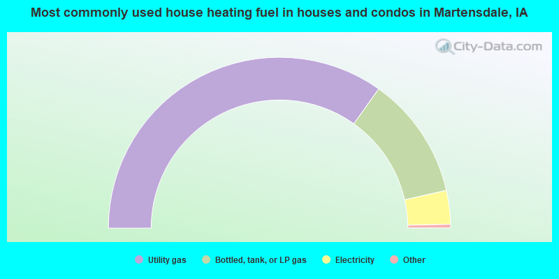
- 70.2%Utility gas
- 23.4%Bottled, tank, or LP gas
- 6.4%Electricity
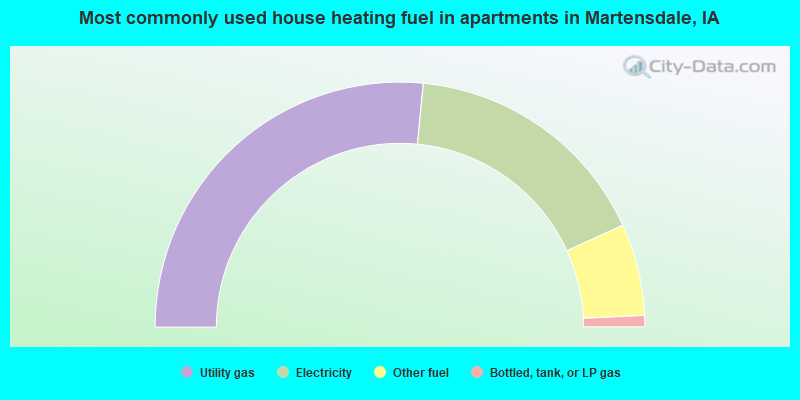
- 53.0%Utility gas
- 33.3%Electricity
- 12.1%Other fuel
- 1.5%Bottled, tank, or LP gas
Martensdale compared to Iowa state average:
- Median household income below state average.
- Unemployed percentage significantly below state average.
- Black race population percentage significantly below state average.
- Hispanic race population percentage significantly below state average.
- Median age significantly below state average.
- Foreign-born population percentage significantly below state average.
- Length of stay since moving in significantly above state average.
- Number of college students below state average.
- Percentage of population with a bachelor's degree or higher below state average.