Bridge Statistics for Martinsville, Indiana (IN)
Condition, Traffic, Stress, Structural Evaluation, Project Costs
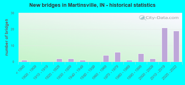
- New bridges - historical statistics
- 1Before 1900
- 21920-1929
- 21930-1939
- 11940-1949
- 41960-1969
- 61970-1979
- 11980-1989
- 51990-1999
- 22000-2009
- 212010-2019
- 192020-2022
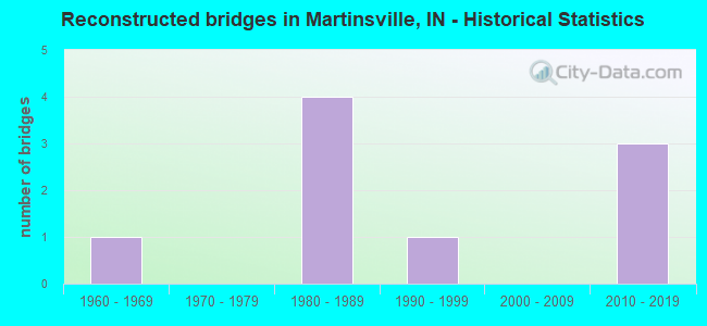
- Reconstructed bridges - Historical Statistics
- 11960-1969
- 01970-1979
- 41980-1989
- 11990-1999
- 02000-2009
- 32010-2019
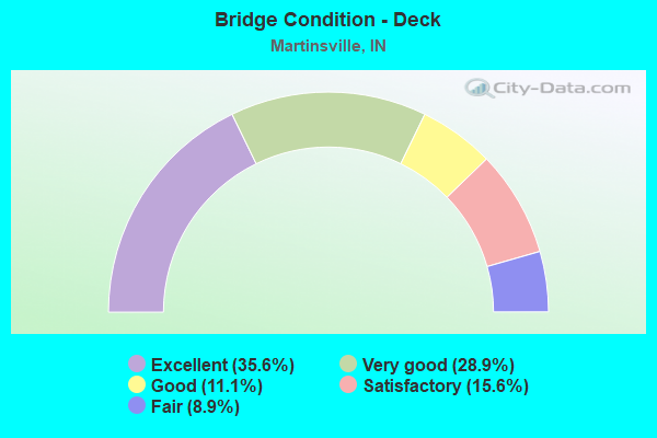
- Bridge Condition - Deck
- 35.6%Excellent
- 28.9%Very good
- 11.1%Good
- 15.6%Satisfactory
- 8.9%Fair
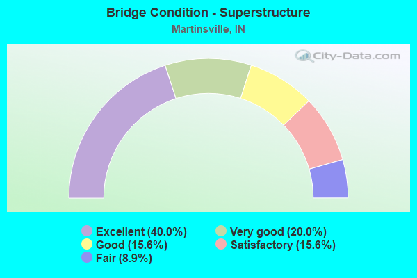
- Bridge Condition - Superstructure
- 40.0%Excellent
- 20.0%Very good
- 15.6%Good
- 15.6%Satisfactory
- 8.9%Fair
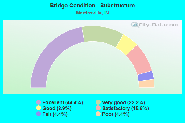
- Bridge Condition - Substructure
- 44.4%Excellent
- 22.2%Very good
- 8.9%Good
- 15.6%Satisfactory
- 4.4%Fair
- 4.4%Poor
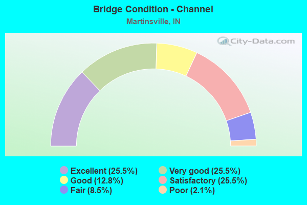
- Bridge Condition - Channel
- 25.5%Excellent
- 25.5%Very good
- 12.8%Good
- 25.5%Satisfactory
- 8.5%Fair
- 2.1%Poor
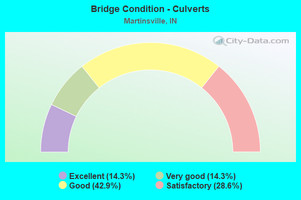
- Bridge Condition - Culverts
- 14.3%Excellent
- 14.3%Very good
- 42.9%Good
- 28.6%Satisfactory
Find on map >> Show street view
Structure Number: 5500092, Location: 02.22 S SR 39 (Lat: 39.379019, Lng: -86.474619), Route carried "on" structure: Ramp County highway , Year Built: 2018, Status: Open, Structure Length: 1.84m (6.04ft), Average Daily Traffic: 726 (year 2016), Truck Traffic: 2%, Average Future Daily Traffic: 966 (year 2035), Design Load: HL 93, Features Intersected: JORDAN CREEK, Facility Carried by Structure: LEGENDARY DRIVE
Minimum Vertical Clearance: 30+ m (98+ ft), Kilometerpoint: 0.000, Lanes on structure: 2, Owner: County Highway Agency, Approaching Roadway Width: 11.0m (36.1ft), Material/Design: Prestressed concrete, Design/Construction: Box Beam or Girders - Single/Spread, Number Of Spans In Main Unit: 1, Length of Maximum Span: 17.5m (57.4ft), Curb-To-Curb Width: 11.0m (36.1ft), Out-to-Out Width: 11.9m (39.0ft)
Condition: Deck: Very good, Superstructure: Very good, Substructure: Excellent, Channel: Very good, Operating Rating: 87.5 metric tons, Method Used To Determine Operating Rating: Load and Resistance Factor (LRFR), Inventory Rating: 45.7 metric tons, Method Used To Determine Inventory Rating: Load and Resistance Factor (LRFR), Structural Evaluation: Equal to present desirable criteria, Deck Geometry: Better than present minimum criteria, Waterway Adequacy: Equal to present desirable criteria, Approach Roadway Alignment: Equal to present desirable criteria, Designated Inspection Frequency: Every 24 months, Inspection Date: March 2022, Deck Structure Type: Concrete Cast-file-Place, Wearing Surface/Protective System: Wearing Surface: Monolithic Concrete, Deck Protection: Epoxy Coated Reinforcing
Find on map >> Show street view
Structure Number: 5500093, Location: 02.22 S SR 39 (Lat: 39.378350, Lng: -86.473539), Route carried "on" structure: County highway , Year Built: 2018, Status: Open, Structure Length: 1.66m (5.45ft), Average Daily Traffic: 400 (year 2016), Truck Traffic: 1%, Average Future Daily Traffic: 400 (year 2035), Design Load: HL 93, Features Intersected: JORDAN CREEK, Facility Carried by Structure: EAST HACKER CR RD
Minimum Vertical Clearance: 30+ m (98+ ft), Kilometerpoint: 0.000, Lanes on structure: 2, Owner: County Highway Agency, Approaching Roadway Width: 11.0m (36.1ft), Material/Design: Prestressed concrete, Design/Construction: Box Beam or Girders - Single/Spread, Number Of Spans In Main Unit: 1, Length of Maximum Span: 15.6m (51.2ft), Curb-To-Curb Width: 11.0m (36.1ft), Out-to-Out Width: 11.9m (39.0ft)
Condition: Deck: Very good, Superstructure: Excellent, Substructure: Excellent, Channel: Very good, Operating Rating: 76.0 metric tons, Method Used To Determine Operating Rating: Load and Resistance Factor (LRFR), Inventory Rating: 50.0 metric tons, Method Used To Determine Inventory Rating: Load and Resistance Factor (LRFR), Structural Evaluation: Superior to present desirable criteria, Deck Geometry: Equal to present desirable criteria, Waterway Adequacy: Equal to present desirable criteria, Approach Roadway Alignment: Equal to present desirable criteria, Designated Inspection Frequency: Every 24 months, Inspection Date: March 2022, Deck Structure Type: Concrete Cast-file-Place, Wearing Surface/Protective System: Wearing Surface: Monolithic Concrete, Deck Protection: Epoxy Coated Reinforcing
Find on map >> Show street view
Structure Number: 5500105, Location: 00.50 S LIBERTY CURCH RD (Lat: 39.371739, Lng: -86.481681), Route carried "on" structure: County highway , Year Built: 2017, Status: Open, Structure Length: 2.38m (7.81ft), Average Daily Traffic: 590 (year 2018), Truck Traffic: 2%, Average Future Daily Traffic: 1,030 (year 2038), Design Load: HL 93, Features Intersected: LITTLE INDIAN CREEK, Facility Carried by Structure: TURKEY TRACK ROAD
Minimum Vertical Clearance: 30+ m (98+ ft), Kilometerpoint: 0.000, Lanes on structure: 2, Owner: County Highway Agency, Approaching Roadway Width: 11.0m (36.1ft), Skew: 1 degrees, Material/Design: Prestressed concrete, Design/Construction: Stringer/Multi-beam, Number Of Spans In Main Unit: 1, Length of Maximum Span: 23.1m (75.8ft), Curb-To-Curb Width: 11.0m (36.1ft), Out-to-Out Width: 11.9m (39.0ft)
Condition: Deck: Very good, Superstructure: Very good, Substructure: Very good, Channel: Very good, Operating Rating: 32.7 metric tons, Method Used To Determine Operating Rating: Field evaluation and documented engineering judgment, Inventory Rating: 32.7 metric tons, Method Used To Determine Inventory Rating: Field evaluation and documented engineering judgment, Structural Evaluation: Equal to present desirable criteria, Deck Geometry: Better than present minimum criteria, Waterway Adequacy: Equal to present desirable criteria, Approach Roadway Alignment: Equal to present desirable criteria, Designated Inspection Frequency: Every 24 months, Inspection Date: August 2020, Deck Structure Type: Concrete Cast-file-Place, Wearing Surface/Protective System: Wearing Surface: Monolithic Concrete, Deck Protection: Epoxy Coated Reinforcing
Find on map >> Show street view
Structure Number: 5500121, Location: 00.53 E OF MOSIER RD (Lat: 39.424019, Lng: -86.475297), Route carried "on" structure: County highway 98, Year Built: 1893, Status: Posted for load, Structure Length: 2.62m (8.60ft), Average Daily Traffic: 230 (year 2018), Truck Traffic: 5%, Average Future Daily Traffic: 400 (year 2038), Features Intersected: LAMBS CREEK, Facility Carried by Structure: OLD SR 67
Minimum Vertical Clearance: 4.12m (13.52ft), Kilometerpoint: 0.000, Lanes on structure: 1, Owner: County Highway Agency, Approaching Roadway Width: 3.7m (12.1ft), Material/Design: Aluminum, Iron, Design/Construction: Truss - Thru, Number Of Spans In Main Unit: 1, Length of Maximum Span: 25.9m (85.0ft), Curb-To-Curb Width: 4.8m (15.7ft), Out-to-Out Width: 4.9m (16.1ft)
Condition: Deck: Good, Superstructure: Satisfactory, Substructure: Satisfactory, Channel: Satisfactory, Operating Rating: 22.4 metric tons, Method Used To Determine Operating Rating: Load Factor (LF), Inventory Rating: 13.4 metric tons, Method Used To Determine Inventory Rating: Load Factor (LF), Structural Evaluation: Meets minimum limits, Deck Geometry: High priority of corrective action, Waterway Adequacy: Equal to present minimum criteria, Approach Roadway Alignment: Equal to present minimum criteria, Bridge Posting: Required (Relationship of Operating Rating to Maximum Legal Load: 30.0 - 39.9% below), Length Of Structure Improvement: 2.62m (8.60ft), Designated Inspection Frequency: Every 24 months, Critical Feature Inspection Frequency: Every 24 months, Inspection Date: August 2020, Critical Feature Inspection Date: August 2020, Bridge Improvement Cost: $185,000, Roadway Improvement Cost: $174,000, Total Project Cost: $435,000 ( Estimate for 2018), Deck Structure Type: Open Grating, Wearing Surface/Protective System: Wearing Surface: Other
Find on map >> Show street view
Structure Number: 5500126, Location: 00.03 N OF MAPLE TURN RD (Lat: 39.475561, Lng: -86.372711), Route carried "on" structure: County highway 369, Year Built: 1940, Year Reconstructed: 1992, Status: Open, Structure Length: 3.38m (11.09ft), Average Daily Traffic: 1,130 (year 2018), Truck Traffic: 5%, Average Future Daily Traffic: 1,980 (year 2038), Design Load: HS 20, Features Intersected: CLEAR CREEK, Facility Carried by Structure: OLD SR 37
Minimum Vertical Clearance: 30+ m (98+ ft), Kilometerpoint: 0.000, Lanes on structure: 2, Owner: County Highway Agency, Approaching Roadway Width: 5.5m (18.0ft), Skew: 2 degrees, Material/Design: Prestressed concrete continuous, Design/Construction: Box Beam or Girders - Single/Spread, Number Of Spans In Main Unit: 3, Length of Maximum Span: 11.3m (37.1ft), Curb-To-Curb Width: 8.7m (28.5ft), Out-to-Out Width: 9.8m (32.2ft)
Condition: Deck: Satisfactory, Superstructure: Satisfactory, Substructure: Satisfactory, Channel: Satisfactory, Operating Rating: 43.9 metric tons, Method Used To Determine Operating Rating: Load and Resistance Factor (LRFR), Inventory Rating: 32.6 metric tons, Method Used To Determine Inventory Rating: Load and Resistance Factor (LRFR), Structural Evaluation: Equal to present minimum criteria, Deck Geometry: Somewhat better than minimum adequacy, Waterway Adequacy: Better than present minimum criteria, Approach Roadway Alignment: Equal to present minimum criteria, Designated Inspection Frequency: Every 24 months, Inspection Date: August 2020, Deck Structure Type: Concrete Cast-file-Place, Wearing Surface/Protective System: Wearing Surface: Monolithic Concrete, Deck Protection: Epoxy Coated Reinforcing
Find on map >> Show street view
Structure Number: 550015, Location: 00.14 S OF JORDAN ROAD (Lat: 39.366603, Lng: -86.443225), Route carried "on" structure: County highway 185, Year Built: 1968, Status: Posted for load, Structure Length: 0.84m (2.76ft), Average Daily Traffic: 160 (year 2018), Truck Traffic: 5%, Average Future Daily Traffic: 280 (year 2038), Features Intersected: JORDAN CREEK, Facility Carried by Structure: HINSON RD
Minimum Vertical Clearance: 30+ m (98+ ft), Kilometerpoint: 0.000, Lanes on structure: 2, Owner: County Highway Agency, Approaching Roadway Width: 5.5m (18.0ft), Material/Design: Steel, Design/Construction: Stringer/Multi-beam, Number Of Spans In Main Unit: 1, Length of Maximum Span: 7.8m (25.6ft), Curb-To-Curb Width: 7.3m (24.0ft), Out-to-Out Width: 7.4m (24.3ft)
Condition: Deck: Satisfactory, Superstructure: Fair, Substructure: Satisfactory, Channel: Satisfactory, Operating Rating: 23.5 metric tons, Method Used To Determine Operating Rating: Load Factor (LF), Inventory Rating: 14.1 metric tons, Method Used To Determine Inventory Rating: Load Factor (LF), Structural Evaluation: Meets minimum limits, Deck Geometry: Somewhat better than minimum adequacy, Waterway Adequacy: Equal to present minimum criteria, Approach Roadway Alignment: High priority of corrective action, Bridge Posting: Required (Relationship of Operating Rating to Maximum Legal Load: 20.0 - 29.9% below), Length Of Structure Improvement: 0.82m (2.69ft), Designated Inspection Frequency: Every 24 months, Inspection Date: August 2020, Bridge Improvement Cost: $60,000, Roadway Improvement Cost: $176,000, Total Project Cost: $286,000 ( Estimate for 2018), Deck Structure Type: Concrete Cast-file-Place, Wearing Surface/Protective System: Wearing Surface: Bituminous
Find on map >> Show street view
Structure Number: 5500159, Location: 00.06 E OF S HOME AVE (Lat: 39.418011, Lng: -86.414161), Route carried "on" structure: City street , Year Built: 2001, Status: Open, Structure Length: 0.70m (2.30ft), Average Daily Traffic: 450 (year 2018), Truck Traffic: 10%, Average Future Daily Traffic: 790 (year 2038), Design Load: HS 20, Features Intersected: SARTOR DITCH, Facility Carried by Structure: YORK ST
Minimum Vertical Clearance: 30+ m (98+ ft), Kilometerpoint: 0.000, Lanes on structure: 2, Owner: City or Municipal Highway Agency, Approaching Roadway Width: 9.1m (29.9ft), Material/Design: Concrete, Design/Construction: Culvert, Number Of Spans In Main Unit: 1, Length of Maximum Span: 6.4m (21.0ft), Curb or Sidewalk Widths: Left: 1.5m (4.9ft), Right: 1.5m (4.9ft), Curb-To-Curb Width: 9.1m (29.9ft), Out-to-Out Width: 19.2m (63.0ft)
Condition: Channel: Good, Culverts: Good, Operating Rating: 32.7 metric tons, Method Used To Determine Operating Rating: Field evaluation and documented engineering judgment, Inventory Rating: 32.7 metric tons, Method Used To Determine Inventory Rating: Field evaluation and documented engineering judgment, Structural Evaluation: Better than present minimum criteria, Deck Geometry: Equal to present minimum criteria, Waterway Adequacy: Better than present minimum criteria, Approach Roadway Alignment: Equal to present desirable criteria, Designated Inspection Frequency: Every 24 months, Inspection Date: August 2020
Find on map >> Show street view
Structure Number: 5500169, Location: 00.24 W OF IN 37 (Lat: 39.374611, Lng: -86.482858), Route carried "on" structure: County highway 4, Year Built: 2010, Status: Open, Structure Length: 1.91m (6.27ft), Average Daily Traffic: 100 (year 2018), Truck Traffic: 5%, Average Future Daily Traffic: 180 (year 2038), Design Load: HS 20, Features Intersected: LITTLE INDIAN CREEK, Facility Carried by Structure: GODSEY RD
Minimum Vertical Clearance: 30+ m (98+ ft), Kilometerpoint: 0.000, Lanes on structure: 2, Owner: County Highway Agency, Approaching Roadway Width: 5.5m (18.0ft), Material/Design: Steel, Design/Construction: Stringer/Multi-beam, Number Of Spans In Main Unit: 1, Length of Maximum Span: 18.2m (59.7ft), Curb-To-Curb Width: 6.7m (22.0ft), Out-to-Out Width: 7.3m (24.0ft)
Condition: Deck: Very good, Superstructure: Very good, Substructure: Very good, Channel: Good, Operating Rating: 58.7 metric tons, Method Used To Determine Operating Rating: Load and Resistance Factor (LRFR), Inventory Rating: 58.7 metric tons, Method Used To Determine Inventory Rating: Load and Resistance Factor (LRFR), Structural Evaluation: Equal to present desirable criteria, Deck Geometry: Somewhat better than minimum adequacy, Waterway Adequacy: Equal to present minimum criteria, Approach Roadway Alignment: Equal to present minimum criteria, Designated Inspection Frequency: Every 24 months, Inspection Date: August 2020, Deck Structure Type: Concrete Cast-file-Place, Wearing Surface/Protective System: Wearing Surface: Monolithic Concrete
Find on map >> Show street view
Structure Number: 5500179, Location: 00.22 E IN 37 (Lat: 39.369786, Lng: -86.480186), Route carried "on" structure: County highway 270, Year Built: 2015, Status: Open, Structure Length: 3.09m (10.14ft), Average Daily Traffic: 150 (year 2018), Truck Traffic: 5%, Average Future Daily Traffic: 260 (year 2038), Design Load: HL 93, Features Intersected: LITTLE INDIAN CREEK, Facility Carried by Structure: OLD SR 37
Minimum Vertical Clearance: 30+ m (98+ ft), Kilometerpoint: 0.000, Lanes on structure: 2, Owner: County Highway Agency, Approaching Roadway Width: 9.8m (32.2ft), Material/Design: Prestressed concrete, Design/Construction: Tee Beam, Number Of Spans In Main Unit: 1, Length of Maximum Span: 30.5m (100.1ft), Curb-To-Curb Width: 11.7m (38.4ft), Out-to-Out Width: 12.6m (41.3ft)
Condition: Deck: Very good, Superstructure: Very good, Substructure: Very good, Channel: Very good, Operating Rating: 66.3 metric tons, Method Used To Determine Operating Rating: Load and Resistance Factor (LRFR), Inventory Rating: 33.7 metric tons, Method Used To Determine Inventory Rating: Load and Resistance Factor (LRFR), Structural Evaluation: Equal to present desirable criteria, Deck Geometry: Superior to present desirable criteria, Waterway Adequacy: Superior to present desirable criteria, Approach Roadway Alignment: Equal to present desirable criteria, Designated Inspection Frequency: Every 24 months, Inspection Date: August 2020, Deck Structure Type: Concrete Cast-file-Place, Wearing Surface/Protective System: Wearing Surface: Monolithic Concrete
Find on map >> Show street view
Structure Number: 5500181, Location: 00.20 W S MOSIER RD (Lat: 39.454719, Lng: -86.506822), Route carried "on" structure: County highway 120, Year Built: 2016, Status: Open, Structure Length: 2.26m (7.41ft), Average Daily Traffic: 530 (year 2018), Truck Traffic: 5%, Average Future Daily Traffic: 930 (year 2038), Design Load: HL 93, Features Intersected: BRANCH LAMBS CREEK, Facility Carried by Structure: BIG HURRCANE RD
Minimum Vertical Clearance: 30+ m (98+ ft), Kilometerpoint: 0.000, Lanes on structure: 2, Owner: County Highway Agency, Approaching Roadway Width: 6.4m (21.0ft), Skew: 4 degrees, Material/Design: Concrete continuous, Design/Construction: Slab, Number Of Spans In Main Unit: 3, Length of Maximum Span: 8.8m (28.9ft), Curb-To-Curb Width: 8.5m (27.9ft), Out-to-Out Width: 8.7m (28.5ft)
Condition: Deck: Very good, Superstructure: Very good, Substructure: Very good, Channel: Very good, Operating Rating: 75.9 metric tons, Method Used To Determine Operating Rating: Load and Resistance Factor (LRFR), Inventory Rating: 56.4 metric tons, Method Used To Determine Inventory Rating: Load and Resistance Factor (LRFR), Structural Evaluation: Equal to present desirable criteria, Deck Geometry: Somewhat better than minimum adequacy, Waterway Adequacy: Equal to present minimum criteria, Approach Roadway Alignment: Equal to present minimum criteria, Designated Inspection Frequency: Every 24 months, Inspection Date: August 2020, Deck Structure Type: Concrete Cast-file-Place, Wearing Surface/Protective System: Wearing Surface: Monolithic Concrete, Deck Protection: Epoxy Coated Reinforcing
Find on map >> Show street view
Structure Number: 5500184, Location: 00.50 E 250 E (Lat: 39.420100, Lng: -86.371797), Route carried "on" structure: County highway 8, Year Built: 2016, Status: Open, Structure Length: 1.52m (4.99ft), Average Daily Traffic: 900 (year 2018), Truck Traffic: 5%, Average Future Daily Traffic: 1,580 (year 2038), Design Load: HL 93, Features Intersected: W FORK CLEAR CREEK, Facility Carried by Structure: OLD MORGANTOWN RD
Minimum Vertical Clearance: 30+ m (98+ ft), Kilometerpoint: 0.000, Lanes on structure: 2, Owner: County Highway Agency, Approaching Roadway Width: 7.2m (23.6ft), Material/Design: Steel, Design/Construction: Stringer/Multi-beam, Number Of Spans In Main Unit: 1, Length of Maximum Span: 14.6m (47.9ft), Curb-To-Curb Width: 8.5m (27.9ft), Out-to-Out Width: 8.5m (27.9ft)
Condition: Deck: Excellent, Superstructure: Excellent, Substructure: Excellent, Channel: Very good, Operating Rating: 68.5 metric tons, Method Used To Determine Operating Rating: Load Factor (LF), Inventory Rating: 41.0 metric tons, Method Used To Determine Inventory Rating: Load Factor (LF), Structural Evaluation: Superior to present desirable criteria, Deck Geometry: Somewhat better than minimum adequacy, Waterway Adequacy: Better than present minimum criteria, Approach Roadway Alignment: Equal to present minimum criteria, Designated Inspection Frequency: Every 24 months, Inspection Date: August 2020, Deck Structure Type: Concrete Cast-file-Place, Wearing Surface/Protective System: Wearing Surface: Bituminous
Find on map >> Show street view
Structure Number: 5500186, Location: 00.17 E IN 37 (Lat: 39.449489, Lng: -86.382453), Route carried "on" structure: County highway 56, Year Built: 2016, Status: Open, Structure Length: 1.25m (4.10ft), Average Daily Traffic: 250 (year 2018), Truck Traffic: 5%, Average Future Daily Traffic: 440 (year 2038), Design Load: HS 20, Features Intersected: W FORK CLEAR CREEK, Facility Carried by Structure: TEETERS RD
Minimum Vertical Clearance: 30+ m (98+ ft), Kilometerpoint: 0.000, Lanes on structure: 2, Owner: County Highway Agency, Approaching Roadway Width: 6.4m (21.0ft), Material/Design: Steel, Design/Construction: Stringer/Multi-beam, Number Of Spans In Main Unit: 1, Length of Maximum Span: 11.9m (39.0ft), Curb-To-Curb Width: 7.2m (23.6ft), Out-to-Out Width: 7.4m (24.3ft)
Condition: Deck: Excellent, Superstructure: Excellent, Substructure: Excellent, Channel: Excellent, Inventory Rating: 95.4 metric tons, Method Used To Determine Inventory Rating: Load Factor (LF), Structural Evaluation: Superior to present desirable criteria, Waterway Adequacy: Better than present minimum criteria, Approach Roadway Alignment: Equal to present minimum criteria, Designated Inspection Frequency: Every 24 months, Inspection Date: August 2020, Deck Structure Type: Concrete Cast-file-Place, Wearing Surface/Protective System: Wearing Surface: Monolithic Concrete
Find on map >> Show street view
Structure Number: 5500196, Location: 00.12 S OF CRAMERTOWN LOO (Lat: 39.396161, Lng: -86.407875), Route carried "on" structure: County highway 39, Year Built: 2018, Status: Open, Structure Length: 0.82m (2.69ft), Average Daily Traffic: 1,130 (year 2018), Truck Traffic: 5%, Average Future Daily Traffic: 1,980 (year 2038), Design Load: HL 93, Features Intersected: SAND CREEK, Facility Carried by Structure: MAHALASVILLE RD
Minimum Vertical Clearance: 30+ m (98+ ft), Kilometerpoint: 0.000, Lanes on structure: 2, Owner: County Highway Agency, Approaching Roadway Width: 6.1m (20.0ft), Material/Design: Steel, Design/Construction: Culvert, Number Of Spans In Main Unit: 1, Length of Maximum Span: 7.8m (25.6ft), Curb-To-Curb Width: 6.1m (20.0ft), Out-to-Out Width: 6.1m (20.0ft)
Condition: Channel: Excellent, Culverts: Very good, Operating Rating: 32.7 metric tons, Method Used To Determine Operating Rating: Field evaluation and documented engineering judgment, Inventory Rating: 32.7 metric tons, Method Used To Determine Inventory Rating: Field evaluation and documented engineering judgment, Structural Evaluation: Equal to present desirable criteria, Deck Geometry: High priority of replacement, Waterway Adequacy: Equal to present minimum criteria, Approach Roadway Alignment: Equal to present minimum criteria, Designated Inspection Frequency: Every 24 months, Inspection Date: August 2020, Wearing Surface/Protective System: Wearing Surface: Bituminous
Find on map >> Show street view
Structure Number: 5500303, Location: 0.26 E. MAHALASVILLE RD. (Lat: 39.406261, Lng: -86.409500), Route carried "on" structure: City street , Year Built: 2020, Status: Open, Structure Length: 0.69m (2.26ft), Average Daily Traffic: 3,000 (year 2020), Truck Traffic: 5%, Average Future Daily Traffic: 4,000 (year 2040), Design Load: HL 93, Features Intersected: UNT TO INDIAN CREEK, Facility Carried by Structure: ARTESIAN AVENUE
Minimum Vertical Clearance: 30+ m (98+ ft), Kilometerpoint: 0.000, Lanes on structure: 2, Owner: State Highway Agency, Approaching Roadway Width: 12.2m (40.0ft), Skew: 1 degrees, Material/Design: Concrete, Design/Construction: Culvert, Number Of Spans In Main Unit: 1, Length of Maximum Span: 6.2m (20.3ft), Curb-To-Curb Width: 12.2m (40.0ft), Out-to-Out Width: 17.1m (56.1ft)
Condition: Channel: Excellent, Culverts: Excellent, Operating Rating: 54.8 metric tons, Method Used To Determine Operating Rating: Load and Resistance Factor Rating (LRFR) rating reported by rating factor(RF) method using HL-93 loadings, Inventory Rating: 42.1 metric tons, Method Used To Determine Inventory Rating: Load and Resistance Factor Rating (LRFR) rating reported by rating factor(RF) method using HL-93 loadings, Structural Evaluation: Superior to present desirable criteria, Deck Geometry: Equal to present minimum criteria, Waterway Adequacy: Superior to present desirable criteria, Approach Roadway Alignment: Equal to present desirable criteria, Designated Inspection Frequency: Every 24 months, Inspection Date: June 2020
Find on map >> Show street view
Structure Number: 12311, Location: 00.11 N SR 39 (Lat: 39.402961, Lng: -86.445881), Route carried "under" structure: Ramp State highway 39, Year Built: 2021, Structure Length: 0. m, Average Daily Traffic: 4,290 (year 2016), Truck Traffic: 8%, Features Intersected: SR-39, Facility Carried by Structure: SR 37 NB
Minimum Vertical Clearance: 5.03m (16.50ft), Kilometerpoint: 0.612, Lanes on structure: 3, Lanes under structure: 2, Material/Design: Prestressed concrete, Design/Construction: Tee Beam, Length of Maximum Span: 21.9m (71.9ft)
Find on map >> Show street view
Structure Number: 12321, Location: 00.11 N SR-39 (Lat: 39.403161, Lng: -86.445989), Route carried "under" structure: Ramp State highway 39, Year Built: 2021, Structure Length: 0. m, Average Daily Traffic: 4,290 (year 2016), Truck Traffic: 8%, Features Intersected: SR-39, Facility Carried by Structure: SR 37 SB
Minimum Vertical Clearance: 5.03m (16.50ft), Kilometerpoint: 0.628, Lanes on structure: 2, Lanes under structure: 2, Material/Design: Prestressed concrete, Design/Construction: Tee Beam, Length of Maximum Span: 21.9m (71.9ft)
Find on map >> Show street view
Structure Number: 79028, Location: 02.46 S SR 39 (Lat: 39.376031, Lng: -86.476769), Route carried "under" structure: Interstate 37, Year Built: 2017, Structure Length: 0. m, Average Daily Traffic: 23,500 (year 2016), Truck Traffic: 21%, Features Intersected: I-69 SB, Facility Carried by Structure: LIBERTY CHURCH RD
Minimum Vertical Clearance: 4.91m (16.11ft), Kilometerpoint: 4.989, Lanes on structure: 2, Lanes under structure: 4, Material/Design: Prestressed concrete continuous, Design/Construction: Stringer/Multi-beam, Length of Maximum Span: 27.1m (88.9ft)
Find on map >> Show street view
Structure Number: 79028, Location: 02.46 S SR 39 (Lat: 39.376031, Lng: -86.476769), Route carried "under" structure: Interstate 37, Year Built: 2017, Structure Length: 0. m, Average Daily Traffic: 23,809 (year 2016), Truck Traffic: 21%, Features Intersected: I-69 NB, Facility Carried by Structure: LIBERTY CHURCH RD
Minimum Vertical Clearance: 5.06m (16.60ft), Kilometerpoint: 4.989, Lanes on structure: 2, Lanes under structure: 4, Material/Design: Prestressed concrete continuous, Design/Construction: Stringer/Multi-beam, Length of Maximum Span: 27.1m (88.9ft)
Find on map >> Show street view
Structure Number: 80764, Location: 02,22 S SR-39 (Lat: 39.430831, Lng: -86.395000), Route carried "under" structure: Ramp US 37, Year Built: 2021, Structure Length: 0. m, Average Daily Traffic: 2,000 (year 2016), Truck Traffic: 5%, Features Intersected: SR 37 NBL RAMP, Facility Carried by Structure: SR 44/REUBEN DRIVE
Minimum Vertical Clearance: 5.36m (17.59ft), Kilometerpoint: 0.000, Lanes on structure: 3, Lanes under structure: 7, Material/Design: Prestressed concrete continuous, Design/Construction: Tee Beam, Length of Maximum Span: 39.3m (128.9ft)
Find on map >> Show street view
Structure Number: 80764, Location: 02,22 S SR-39 (Lat: 39.430831, Lng: -86.395000), Route carried "under" structure: US 37, Year Built: 2021, Structure Length: 0. m, Average Daily Traffic: 18,920 (year 2016), Truck Traffic: 5%, Features Intersected: SR 37 NBL, Facility Carried by Structure: SR 44/REUBEN DRIVE
Minimum Vertical Clearance: 5.29m (17.36ft), Kilometerpoint: 0.000, Lanes on structure: 3, Lanes under structure: 7, Material/Design: Prestressed concrete continuous, Design/Construction: Tee Beam, Length of Maximum Span: 39.3m (128.9ft)
Find on map >> Show street view
Structure Number: 80764, Location: 02,22 S SR-39 (Lat: 39.430831, Lng: -86.395000), Route carried "under" structure: US 37, Year Built: 2021, Structure Length: 0. m, Average Daily Traffic: 34,680 (year 2016), Truck Traffic: 5%, Features Intersected: SR 37 SBL, Facility Carried by Structure: SR 44/REUBEN DRIVE
Minimum Vertical Clearance: 5.22m (17.13ft), Kilometerpoint: 0.000, Lanes on structure: 3, Lanes under structure: 7, Material/Design: Prestressed concrete continuous, Design/Construction: Tee Beam, Length of Maximum Span: 39.3m (128.9ft)
Find on map >> Show street view
Structure Number: 80764, Location: 02,22 S SR-39 (Lat: 39.430831, Lng: -86.395000), Route carried "under" structure: Ramp US 37, Year Built: 2021, Structure Length: 0. m, Average Daily Traffic: 2,000 (year 2016), Truck Traffic: 5%, Features Intersected: SR 37 SBL RAMP, Facility Carried by Structure: SR 44/REUBEN DRIVE
Minimum Vertical Clearance: 5.28m (17.32ft), Kilometerpoint: 0.000, Lanes on structure: 3, Lanes under structure: 7, Material/Design: Prestressed concrete continuous, Design/Construction: Tee Beam, Length of Maximum Span: 39.3m (128.9ft)
Find on map >> Show street view
Structure Number: 80768, Location: 02.22 N SR 39 (Lat: 39.416831, Lng: -86.412300), Route carried "under" structure: State highway 37, Year Built: 2020, Structure Length: 0. m, Average Daily Traffic: 19,000 (year 2019), Truck Traffic: 29%, Features Intersected: SR 37 NBL, Facility Carried by Structure: GRAND VALLEY BLVD.
Minimum Vertical Clearance: 5.05m (16.57ft), Kilometerpoint: 0.000, Lanes on structure: 2, Lanes under structure: 4, Material/Design: Prestressed concrete continuous, Design/Construction: Tee Beam, Length of Maximum Span: 39.7m (130.2ft)
Find on map >> Show street view
Structure Number: 80768, Location: 02.22 N SR 39 (Lat: 39.416831, Lng: -86.412300), Route carried "under" structure: State highway 37, Year Built: 2020, Structure Length: 0. m, Average Daily Traffic: 19,000 (year 2019), Truck Traffic: 29%, Features Intersected: SR 37 SBL, Facility Carried by Structure: GRAND VALLEY BLVD.
Minimum Vertical Clearance: 5.66m (18.57ft), Kilometerpoint: 0.000, Lanes on structure: 2, Lanes under structure: 4, Material/Design: Prestressed concrete continuous, Design/Construction: Tee Beam, Length of Maximum Span: 39.7m (130.2ft)
Find on map >> Show street view
Structure Number: 8078, Location: 3.65 N SR 44 (Lat: 39.478061, Lng: -86.366969), Route carried "under" structure: State highway 37, Year Built: 2020, Structure Length: 0. m, Average Daily Traffic: 11,941 (year 2004), Truck Traffic: 10%, Features Intersected: SR 37 NBL, Facility Carried by Structure: EGBERT ROAD
Minimum Vertical Clearance: 5.11m (16.77ft), Kilometerpoint: 0.000, Lanes on structure: 2, Lanes under structure: 6, Material/Design: Prestressed concrete continuous, Design/Construction: Tee Beam, Length of Maximum Span: 44.0m (144.4ft)
Find on map >> Show street view
Structure Number: 8078, Location: 3.65 N SR 44 (Lat: 39.478061, Lng: -86.366969), Route carried "under" structure: State highway 37, Year Built: 2020, Structure Length: 0. m, Average Daily Traffic: 11,941 (year 2004), Truck Traffic: 10%, Features Intersected: SR 37 SBL, Facility Carried by Structure: EGBERT ROAD
Minimum Vertical Clearance: 5.11m (16.77ft), Kilometerpoint: 0.000, Lanes on structure: 2, Lanes under structure: 6, Material/Design: Prestressed concrete continuous, Design/Construction: Tee Beam, Length of Maximum Span: 44.0m (144.4ft)