Bridge Statistics for Marysville, Washington (WA)
Condition, Traffic, Stress, Structural Evaluation, Project Costs
- National Bridge Inventory (NBI) Statistics
- 32Number of bridges
- 1,227ft / 374mTotal length
- $319,433,000Total costs
- 1,373,619Total average daily traffic
- 103,072Total average daily truck traffic
- National Bridge Inventory (NBI) Registered Bridges for Marysville
- No street view available for this location
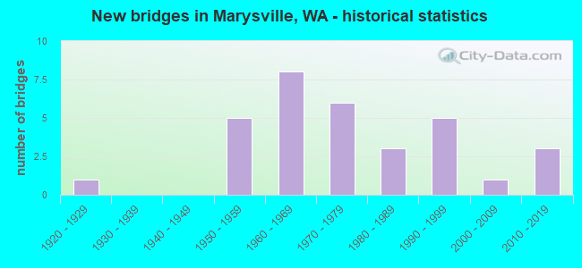
- New bridges - historical statistics
- 11920-1929
- 51950-1959
- 81960-1969
- 61970-1979
- 31980-1989
- 51990-1999
- 12000-2009
- 32010-2019
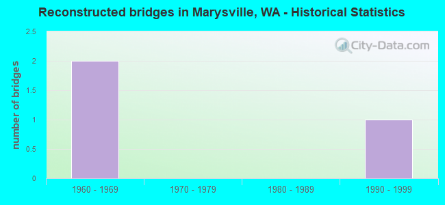
- Reconstructed bridges - Historical Statistics
- 21960-1969
- 01970-1979
- 01980-1989
- 11990-1999
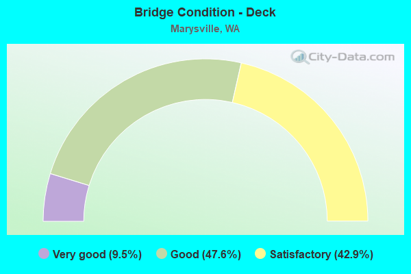
- Bridge Condition - Deck
- 9.5%Very good
- 47.6%Good
- 42.9%Satisfactory
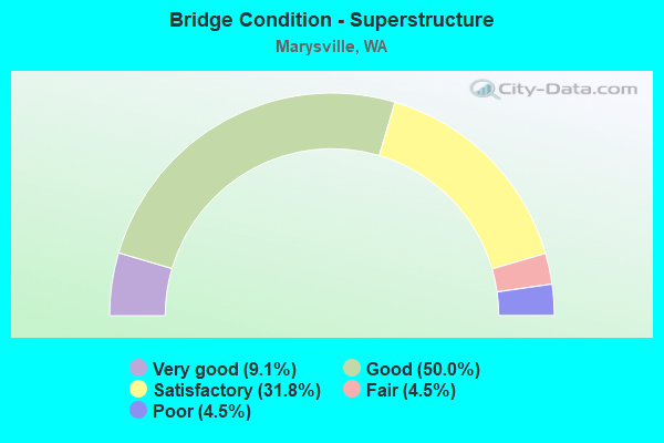
- Bridge Condition - Superstructure
- 9.1%Very good
- 50.0%Good
- 31.8%Satisfactory
- 4.5%Fair
- 4.5%Poor
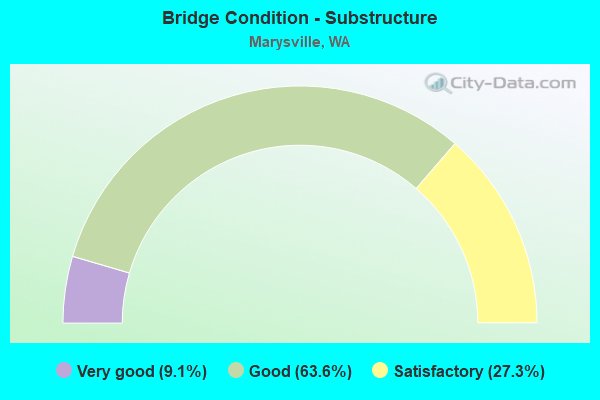
- Bridge Condition - Substructure
- 9.1%Very good
- 63.6%Good
- 27.3%Satisfactory

- Bridge Condition - Channel
- 33.3%Very good
- 46.7%Good
- 20.0%Satisfactory
Find on map >> Show street view
Structure Number: 965C, Location: 6.6 N JCT I-5 (Lat: 48.037167, Lng: -122.182167), Route carried "on" structure: State highway 529, Year Built: 1927, Year Reconstructed: 2003, Status: Open, Structure Length: 26.00m (85.30ft), Average Daily Traffic: 16,795 (year 2019), Truck Traffic: 6%, Average Future Daily Traffic: 24,319 (year 2039), Design Load: H 20, Features Intersected: STEAMBOAT SLOUGH
Minimum Vertical Clearance: 4.67m (15.32ft), Kilometerpoint: 8.723, Lanes on structure: 2, Lanes under structure: 2, Base Highway Network: Yes, Owner: State Highway Agency, Approaching Roadway Width: 10.7m (35.1ft), Navigation Control: Yes ( Vertical Clearance: 3.0m (9.8ft), Horizontal Clearance: 30.5m (100.1ft)), Material/Design: Steel, Design/Construction: Movable - Swing, Number Of Spans In Main Unit: 2, Number Of Approach Spans: 7, Length of Maximum Span: 54.9m (180.1ft), Curb or Sidewalk Widths: Left: 0.0m, Right: 1.1m (3.6ft), Curb-To-Curb Width: 7.3m (24.0ft), Out-to-Out Width: 7.7m (25.3ft)
Condition: Deck: Good, Superstructure: Poor, Substructure: Satisfactory, Channel: Good, Operating Rating: 52.6 metric tons, Method Used To Determine Operating Rating: Load Factor (LF), Inventory Rating: 31.7 metric tons, Method Used To Determine Inventory Rating: Load Factor (LF), Structural Evaluation: Meets minimum limits, Deck Geometry: High priority of replacement, Underclear: High priority of corrective action, Waterway Adequacy: Equal to present desirable criteria, Approach Roadway Alignment: Equal to present desirable criteria, Length Of Structure Improvement: 26.00m (85.30ft), Designated Inspection Frequency: Every 24 months, Critical Feature Inspection Frequency: Every 24 months, Underwater Inspection Frequency: Every 60 months, Other Special Inspection Frequency: Every 24 months, Inspection Date: July 2021, Critical Feature Inspection Date: July 2021, Underwater Inspection Date: July 2020, Other Special Inspection Date: July 2021, Bridge Improvement Cost: $6,312,000, Roadway Improvement Cost: $1,262,000, Total Project Cost: $12,624,000 ( Estimate for 2014), Deck Structure Type: Concrete Cast-file-Place, Wearing Surface/Protective System: Wearing Surface: Epoxy Overlay
Find on map >> Show street view
Structure Number: 4178A, Location: 5.3 N JCT US 2 (Lat: 48.051706, Lng: -122.184739), Route carried "on" structure: Interstate 5, Year Built: 1952, Status: Open, Structure Length: 3.78m (12.40ft), Average Daily Traffic: 65,189 (year 2019), Truck Traffic: 9%, Average Future Daily Traffic: 94,393 (year 2039), Design Load: HS 20, Features Intersected: SR 528 4TH ST
Minimum Vertical Clearance: 30+ m (98+ ft), Kilometerpoint: 320.436, Lanes on structure: 3, Lanes under structure: 4, Base Highway Network: Yes, Owner: State Highway Agency, Approaching Roadway Width: 16.5m (54.1ft), Material/Design: Concrete continuous, Design/Construction: Tee Beam, Number Of Spans In Main Unit: 3, Length of Maximum Span: 16.8m (55.1ft), Curb-To-Curb Width: 17.7m (58.1ft), Out-to-Out Width: 18.4m (60.4ft)
Condition: Deck: Satisfactory, Superstructure: Good, Substructure: Good, Operating Rating: 37.3 metric tons, Method Used To Determine Operating Rating: Load and Resistance Factor Rating (LRFR) rating reported by rating factor(RF) method using HL-93 loadings, Inventory Rating: 28.8 metric tons, Method Used To Determine Inventory Rating: Load and Resistance Factor Rating (LRFR) rating reported by rating factor(RF) method using HL-93 loadings, Structural Evaluation: Better than present minimum criteria, Deck Geometry: Better than present minimum criteria, Underclear: High priority of corrective action, Approach Roadway Alignment: Equal to present desirable criteria, Length Of Structure Improvement: 3.78m (12.40ft), Designated Inspection Frequency: Every 24 months, Inspection Date: March 2021, Bridge Improvement Cost: $1,389,000, Roadway Improvement Cost: $278,000, Total Project Cost: $2,778,000 ( Estimate for 2014), Deck Structure Type: Concrete Cast-file-Place, Wearing Surface/Protective System: Wearing Surface: Bituminous, Membrane: Preformed Fabric
Find on map >> Show street view
Structure Number: 4196A, Location: 4.7 N JCT US 2 (Lat: 48.043389, Lng: -122.180861), Route carried "on" structure: Interstate 5, Year Built: 1954, Year Reconstructed: 1968, Status: Open, Structure Length: 58.52m (191.99ft), Average Daily Traffic: 66,056 (year 2019), Truck Traffic: 6%, Average Future Daily Traffic: 95,649 (year 2039), Design Load: HS 20, Features Intersected: EBEY SL / SR 529 / RR
Minimum Vertical Clearance: 30+ m (98+ ft), Kilometerpoint: 319.471, Lanes on structure: 4, Lanes under structure: 3, Base Highway Network: Yes, Owner: State Highway Agency, Approaching Roadway Width: 15.8m (51.8ft), Material/Design: Steel continuous, Design/Construction: Stringer/Multi-beam, Number Of Spans In Main Unit: 3, Number Of Approach Spans: 25, Length of Maximum Span: 37.8m (124.0ft), Curb or Sidewalk Widths: Left: 1.4m (4.6ft), Right: 1.4m (4.6ft), Curb-To-Curb Width: 16.6m (54.5ft), Out-to-Out Width: 19.9m (65.3ft)
Condition: Deck: Satisfactory, Superstructure: Satisfactory, Substructure: Satisfactory, Channel: Very good, Operating Rating: 41.7 metric tons, Method Used To Determine Operating Rating: Load Factor (LF), Inventory Rating: 24.5 metric tons, Method Used To Determine Inventory Rating: Load Factor (LF), Structural Evaluation: Equal to present minimum criteria, Deck Geometry: Meets minimum limits, Underclear: High priority of corrective action, Waterway Adequacy: Equal to present desirable criteria, Approach Roadway Alignment: Equal to present desirable criteria, Length Of Structure Improvement: 58.52m (191.99ft), Designated Inspection Frequency: Every 24 months, Underwater Inspection Frequency: Every 60 months, Other Special Inspection Frequency: Every 24 months, Inspection Date: October 2020, Underwater Inspection Date: July 2020, Other Special Inspection Date: October 2020, Bridge Improvement Cost: $20,736,000, Roadway Improvement Cost: $4,147,000, Total Project Cost: $41,472,000 ( Estimate for 2014), Deck Structure Type: Concrete Cast-file-Place, Wearing Surface/Protective System: Wearing Surface: Latex Concrete
Find on map >> Show street view
Structure Number: 4352A, Location: 0.9 N JCT SR 528 (Lat: 48.064667, Lng: -122.184778), Route carried "on" structure: Interstate 5, Year Built: 1953, Year Reconstructed: 1971, Status: Open, Structure Length: 3.41m (11.19ft), Average Daily Traffic: 72,777 (year 2019), Truck Traffic: 9%, Average Future Daily Traffic: 105,381 (year 2039), Design Load: HS 20+Mod, Features Intersected: QUILCEDA CREEK
Minimum Vertical Clearance: 30+ m (98+ ft), Kilometerpoint: 321.949, Lanes on structure: 3, Base Highway Network: Yes, Owner: State Highway Agency, Approaching Roadway Width: 15.8m (51.8ft), Material/Design: Concrete continuous, Design/Construction: Slab, Number Of Spans In Main Unit: 5, Length of Maximum Span: 7.3m (24.0ft), Curb or Sidewalk Widths: Left: 0.2m (0.7ft), Right: 0.2m (0.7ft), Curb-To-Curb Width: 15.8m (51.8ft), Out-to-Out Width: 16.6m (54.5ft)
Condition: Deck: Good, Superstructure: Good, Substructure: Good, Channel: Good, Operating Rating: 32.4 metric tons, Method Used To Determine Operating Rating: Load and Resistance Factor Rating (LRFR) rating reported by rating factor(RF) method using HL-93 loadings, Inventory Rating: 24.9 metric tons, Method Used To Determine Inventory Rating: Load and Resistance Factor Rating (LRFR) rating reported by rating factor(RF) method using HL-93 loadings, Structural Evaluation: Equal to present minimum criteria, Deck Geometry: Somewhat better than minimum adequacy, Waterway Adequacy: Equal to present desirable criteria, Approach Roadway Alignment: Equal to present desirable criteria, Length Of Structure Improvement: 3.41m (11.19ft), Designated Inspection Frequency: Every 24 months, Inspection Date: June 2021, Bridge Improvement Cost: $1,210,000, Roadway Improvement Cost: $242,000, Total Project Cost: $2,419,000 ( Estimate for 2014), Deck Structure Type: Concrete Cast-file-Place, Wearing Surface/Protective System: Wearing Surface: Bituminous, Membrane: Preformed Fabric
Find on map >> Show street view
Structure Number: 8226D, Location: 4.1 N JCT US 2 (Lat: 48.035000, Lng: -122.177861), Route carried "on" structure: Interstate 5, Year Built: 1968, Status: Open, Structure Length: 31.27m (102.59ft), Average Daily Traffic: 66,056 (year 2019), Truck Traffic: 6%, Average Future Daily Traffic: 95,649 (year 2039), Design Load: HS 20+Mod, Features Intersected: STEAMBOAT SLOUGH
Minimum Vertical Clearance: 30+ m (98+ ft), Kilometerpoint: 318.489, Lanes on structure: 3, Base Highway Network: Yes, Owner: State Highway Agency, Approaching Roadway Width: 16.5m (54.1ft), Navigation Control: Yes ( Vertical Clearance: 12.2m (40.0ft), Horizontal Clearance: 30.5m (100.1ft)), Material/Design: Prestressed concrete continuous, Design/Construction: Stringer/Multi-beam, Number Of Spans In Main Unit: 9, Length of Maximum Span: 36.9m (121.1ft), Curb or Sidewalk Widths: Left: 0.2m (0.7ft), Right: 0.2m (0.7ft), Curb-To-Curb Width: 14.6m (47.9ft), Out-to-Out Width: 15.7m (51.5ft)
Condition: Deck: Satisfactory, Superstructure: Satisfactory, Substructure: Satisfactory, Channel: Good, Operating Rating: 32.1 metric tons, Method Used To Determine Operating Rating: Load and Resistance Factor Rating (LRFR) rating reported by rating factor(RF) method using HL-93 loadings, Inventory Rating: 20.4 metric tons, Method Used To Determine Inventory Rating: Load and Resistance Factor Rating (LRFR) rating reported by rating factor(RF) method using HL-93 loadings, Structural Evaluation: Somewhat better than minimum adequacy, Deck Geometry: Meets minimum limits, Waterway Adequacy: Equal to present desirable criteria, Approach Roadway Alignment: Equal to present desirable criteria, Length Of Structure Improvement: 31.27m (102.59ft), Designated Inspection Frequency: Every 24 months, Underwater Inspection Frequency: Every 60 months, Inspection Date: March 2020, Underwater Inspection Date: July 2020, Bridge Improvement Cost: $11,491,000, Roadway Improvement Cost: $2,298,000, Total Project Cost: $22,982,000 ( Estimate for 2014), Deck Structure Type: Concrete Cast-file-Place, Wearing Surface/Protective System: Wearing Surface: Latex Concrete
Find on map >> Show street view
Structure Number: 8226E, Location: 4.1 N JCT US 2 (Lat: 48.034944, Lng: -122.177972), Route carried "on" structure: Interstate 5, Year Built: 1968, Status: Open, Structure Length: 31.27m (102.59ft), Average Daily Traffic: 66,056 (year 2019), Truck Traffic: 6%, Average Future Daily Traffic: 95,649 (year 2039), Design Load: HS 20+Mod, Features Intersected: STEAMBOAT SLOUGH
Minimum Vertical Clearance: 30+ m (98+ ft), Kilometerpoint: 318.489, Lanes on structure: 3, Base Highway Network: Yes, Owner: State Highway Agency, Approaching Roadway Width: 16.5m (54.1ft), Navigation Control: Yes ( Vertical Clearance: 12.2m (40.0ft), Horizontal Clearance: 35.7m (117.1ft)), Material/Design: Prestressed concrete continuous, Design/Construction: Stringer/Multi-beam, Number Of Spans In Main Unit: 9, Length of Maximum Span: 36.9m (121.1ft), Curb or Sidewalk Widths: Left: 0.2m (0.7ft), Right: 0.2m (0.7ft), Curb-To-Curb Width: 14.6m (47.9ft), Out-to-Out Width: 15.7m (51.5ft)
Condition: Deck: Satisfactory, Superstructure: Satisfactory, Substructure: Satisfactory, Channel: Satisfactory, Operating Rating: 32.1 metric tons, Method Used To Determine Operating Rating: Load and Resistance Factor Rating (LRFR) rating reported by rating factor(RF) method using HL-93 loadings, Inventory Rating: 20.4 metric tons, Method Used To Determine Inventory Rating: Load and Resistance Factor Rating (LRFR) rating reported by rating factor(RF) method using HL-93 loadings, Structural Evaluation: Somewhat better than minimum adequacy, Deck Geometry: Meets minimum limits, Waterway Adequacy: Equal to present desirable criteria, Approach Roadway Alignment: Equal to present desirable criteria, Length Of Structure Improvement: 31.27m (102.59ft), Designated Inspection Frequency: Every 24 months, Underwater Inspection Frequency: Every 60 months, Inspection Date: March 2020, Underwater Inspection Date: July 2020, Bridge Improvement Cost: $11,491,000, Roadway Improvement Cost: $2,298,000, Total Project Cost: $22,982,000 ( Estimate for 2014), Deck Structure Type: Concrete Cast-file-Place, Wearing Surface/Protective System: Wearing Surface: Latex Concrete
Find on map >> Show street view
Structure Number: 8372A, Location: 4.4 N JCT US 2 (Lat: 48.040139, Lng: -122.179000), Route carried "on" structure: Interstate 5, Year Built: 1968, Status: Open, Structure Length: 7.47m (24.51ft), Average Daily Traffic: 66,056 (year 2019), Truck Traffic: 6%, Average Future Daily Traffic: 95,649 (year 2039), Design Load: HS 20+Mod, Features Intersected: SR 529 NB
Minimum Vertical Clearance: 30+ m (98+ ft), Kilometerpoint: 319.085, Lanes on structure: 3, Lanes under structure: 2, Base Highway Network: Yes, Owner: State Highway Agency, Approaching Roadway Width: 17.1m (56.1ft), Skew: 4 degrees, Material/Design: Prestressed concrete, Design/Construction: Stringer/Multi-beam, Number Of Spans In Main Unit: 3, Length of Maximum Span: 28.7m (94.2ft), Curb or Sidewalk Widths: Left: 0.2m (0.7ft), Right: 0.2m (0.7ft), Curb-To-Curb Width: 15.8m (51.8ft), Out-to-Out Width: 16.9m (55.4ft)
Condition: Deck: Satisfactory, Superstructure: Satisfactory, Substructure: Good, Operating Rating: 17.5 metric tons, Method Used To Determine Operating Rating: Load and Resistance Factor Rating (LRFR) rating reported by rating factor(RF) method using HL-93 loadings, Inventory Rating: 13.6 metric tons, Method Used To Determine Inventory Rating: Load and Resistance Factor Rating (LRFR) rating reported by rating factor(RF) method using HL-93 loadings, Structural Evaluation: High priority of corrective action, Deck Geometry: Somewhat better than minimum adequacy, Underclear: Equal to present minimum criteria, Approach Roadway Alignment: Equal to present desirable criteria, Length Of Structure Improvement: 7.47m (24.51ft), Designated Inspection Frequency: Every 24 months, Inspection Date: Febuary 2020, Bridge Improvement Cost: $2,842,000, Roadway Improvement Cost: $568,000, Total Project Cost: $5,684,000 ( Estimate for 2014), Deck Structure Type: Concrete Cast-file-Place, Wearing Surface/Protective System: Wearing Surface: Latex Concrete
Find on map >> Show street view
Structure Number: 8372B, Location: 4.4 N JCT US 2 (Lat: 48.040000, Lng: -122.179167), Route carried "on" structure: Interstate 5, Year Built: 1968, Status: Posted for load, Structure Length: 6.98m (22.90ft), Average Daily Traffic: 66,056 (year 2019), Truck Traffic: 6%, Average Future Daily Traffic: 95,649 (year 2039), Design Load: HS 20+Mod, Features Intersected: SR 529 NB
Minimum Vertical Clearance: 30+ m (98+ ft), Kilometerpoint: 319.085, Lanes on structure: 3, Lanes under structure: 2, Base Highway Network: Yes, Owner: State Highway Agency, Approaching Roadway Width: 17.1m (56.1ft), Skew: 4 degrees, Material/Design: Prestressed concrete, Design/Construction: Stringer/Multi-beam, Number Of Spans In Main Unit: 3, Length of Maximum Span: 28.7m (94.2ft), Curb or Sidewalk Widths: Left: 0.2m (0.7ft), Right: 0.2m (0.7ft), Curb-To-Curb Width: 15.8m (51.8ft), Out-to-Out Width: 16.9m (55.4ft)
Condition: Deck: Good, Superstructure: Satisfactory, Substructure: Satisfactory, Operating Rating: 15.9 metric tons, Method Used To Determine Operating Rating: Load and Resistance Factor Rating (LRFR) rating reported by rating factor(RF) method using HL-93 loadings, Inventory Rating: 12.3 metric tons, Method Used To Determine Inventory Rating: Load and Resistance Factor Rating (LRFR) rating reported by rating factor(RF) method using HL-93 loadings, Structural Evaluation: High priority of corrective action, Deck Geometry: Somewhat better than minimum adequacy, Underclear: Equal to present minimum criteria, Approach Roadway Alignment: Equal to present desirable criteria, Bridge Posting: Required (Relationship of Operating Rating to Maximum Legal Load: 10.0 - 19.9% below), Length Of Structure Improvement: 6.98m (22.90ft), Designated Inspection Frequency: Every 24 months, Inspection Date: Febuary 2020, Bridge Improvement Cost: $2,656,000, Roadway Improvement Cost: $531,000, Total Project Cost: $5,313,000 ( Estimate for 2014), Deck Structure Type: Concrete Cast-file-Place, Wearing Surface/Protective System: Wearing Surface: Bituminous
Find on map >> Show street view
Structure Number: 8400A, Location: 4.6 N JCT US 2 (Lat: 48.043306, Lng: -122.180528), Route carried "on" structure: Interstate 5, Year Built: 1969, Status: Open, Structure Length: 62.85m (206.20ft), Average Daily Traffic: 66,056 (year 2019), Truck Traffic: 6%, Average Future Daily Traffic: 95,649 (year 2039), Design Load: HS 20+Mod, Features Intersected: SR529,RR,EBEY SL,60TH PL
Minimum Vertical Clearance: 30+ m (98+ ft), Kilometerpoint: 319.455, Lanes on structure: 4, Lanes under structure: 3, Base Highway Network: Yes, Owner: State Highway Agency, Approaching Roadway Width: 18.9m (62.0ft), Navigation Control: Yes ( Vertical Clearance: 12.5m (41.0ft), Horizontal Clearance: 33.5m (109.9ft)), Material/Design: Prestressed concrete continuous, Design/Construction: Stringer/Multi-beam, Number Of Spans In Main Unit: 21, Length of Maximum Span: 37.8m (124.0ft), Curb or Sidewalk Widths: Left: 0.2m (0.7ft), Right: 0.2m (0.7ft), Curb-To-Curb Width: 18.3m (60.0ft), Out-to-Out Width: 19.3m (63.3ft)
Condition: Deck: Satisfactory, Superstructure: Satisfactory, Substructure: Satisfactory, Channel: Good, Operating Rating: 19.4 metric tons, Method Used To Determine Operating Rating: Load and Resistance Factor Rating (LRFR) rating reported by rating factor(RF) method using HL-93 loadings, Inventory Rating: 14.9 metric tons, Method Used To Determine Inventory Rating: Load and Resistance Factor Rating (LRFR) rating reported by rating factor(RF) method using HL-93 loadings, Structural Evaluation: High priority of corrective action, Deck Geometry: Meets minimum limits, Underclear: High priority of corrective action, Waterway Adequacy: Equal to present desirable criteria, Approach Roadway Alignment: Equal to present desirable criteria, Length Of Structure Improvement: 62.85m (206.20ft), Designated Inspection Frequency: Every 48 months, Underwater Inspection Frequency: Every 60 months, Inspection Date: September 2018, Underwater Inspection Date: July 2020, Bridge Improvement Cost: $26,394,000, Roadway Improvement Cost: $5,279,000, Total Project Cost: $52,787,000 ( Estimate for 2014), Deck Structure Type: Concrete Cast-file-Place, Wearing Surface/Protective System: Wearing Surface: Latex Concrete
Find on map >> Show street view
Structure Number: 8632B, Location: 5.0 N JCT SR 528 (Lat: 48.123806, Lng: -122.185111), Route carried "on" structure: Interstate 5, Year Built: 1970, Status: Open, Structure Length: 12.83m (42.09ft), Average Daily Traffic: 58,063 (year 2019), Truck Traffic: 9%, Average Future Daily Traffic: 84,075 (year 2039), Design Load: HS 20+Mod, Features Intersected: BNSF RR
Minimum Vertical Clearance: 30+ m (98+ ft), Kilometerpoint: 328.499, Lanes on structure: 3, Base Highway Network: Yes, Owner: State Highway Agency, Approaching Roadway Width: 16.8m (55.1ft), Skew: 6 degrees, Material/Design: Prestressed concrete continuous, Design/Construction: Stringer/Multi-beam, Number Of Spans In Main Unit: 3, Length of Maximum Span: 41.8m (137.1ft), Curb or Sidewalk Widths: Left: 0.2m (0.7ft), Right: 0.2m (0.7ft), Curb-To-Curb Width: 15.8m (51.8ft), Out-to-Out Width: 16.9m (55.4ft)
Condition: Deck: Good, Superstructure: Good, Substructure: Good, Operating Rating: 23.3 metric tons, Method Used To Determine Operating Rating: Load and Resistance Factor Rating (LRFR) rating reported by rating factor(RF) method using HL-93 loadings, Inventory Rating: 17.8 metric tons, Method Used To Determine Inventory Rating: Load and Resistance Factor Rating (LRFR) rating reported by rating factor(RF) method using HL-93 loadings, Structural Evaluation: Meets minimum limits, Deck Geometry: Somewhat better than minimum adequacy, Underclear: Equal to present desirable criteria, Approach Roadway Alignment: Equal to present desirable criteria, Length Of Structure Improvement: 12.83m (42.09ft), Designated Inspection Frequency: Every 24 months, Inspection Date: March 2020, Bridge Improvement Cost: $4,800,000, Roadway Improvement Cost: $960,000, Total Project Cost: $9,599,000 ( Estimate for 2014), Deck Structure Type: Concrete Cast-file-Place, Wearing Surface/Protective System: Wearing Surface: Bituminous, Membrane: Preformed Fabric
Find on map >> Show street view
Structure Number: 8632C, Location: 5.0 N JCT SR 528 (Lat: 48.124333, Lng: -122.185417), Route carried "on" structure: Interstate 5, Year Built: 1970, Status: Open, Structure Length: 12.83m (42.09ft), Average Daily Traffic: 58,063 (year 2019), Truck Traffic: 9%, Average Future Daily Traffic: 84,075 (year 2039), Design Load: HS 20+Mod, Features Intersected: BNSF RR
Minimum Vertical Clearance: 30+ m (98+ ft), Kilometerpoint: 328.531, Lanes on structure: 3, Base Highway Network: Yes, Owner: State Highway Agency, Approaching Roadway Width: 16.8m (55.1ft), Skew: 6 degrees, Material/Design: Prestressed concrete continuous, Design/Construction: Stringer/Multi-beam, Number Of Spans In Main Unit: 3, Length of Maximum Span: 41.8m (137.1ft), Curb or Sidewalk Widths: Left: 0.2m (0.7ft), Right: 0.2m (0.7ft), Curb-To-Curb Width: 15.8m (51.8ft), Out-to-Out Width: 16.9m (55.4ft)
Condition: Deck: Good, Superstructure: Good, Substructure: Good, Operating Rating: 23.3 metric tons, Method Used To Determine Operating Rating: Load and Resistance Factor Rating (LRFR) rating reported by rating factor(RF) method using HL-93 loadings, Inventory Rating: 17.8 metric tons, Method Used To Determine Inventory Rating: Load and Resistance Factor Rating (LRFR) rating reported by rating factor(RF) method using HL-93 loadings, Structural Evaluation: Meets minimum limits, Deck Geometry: Somewhat better than minimum adequacy, Underclear: Superior to present desirable criteria, Approach Roadway Alignment: Equal to present desirable criteria, Length Of Structure Improvement: 12.83m (42.09ft), Designated Inspection Frequency: Every 24 months, Inspection Date: March 2020, Bridge Improvement Cost: $4,800,000, Roadway Improvement Cost: $960,000, Total Project Cost: $9,599,000 ( Estimate for 2014), Deck Structure Type: Concrete Cast-file-Place, Wearing Surface/Protective System: Wearing Surface: Bituminous, Membrane: Preformed Fabric
Find on map >> Show street view
Structure Number: 8753A, Location: 5.3 N JCT US 2 (Lat: 48.051750, Lng: -122.184417), Route carried "on" structure: Interstate 5, Year Built: 1971, Status: Open, Structure Length: 3.78m (12.40ft), Average Daily Traffic: 65,189 (year 2019), Truck Traffic: 9%, Average Future Daily Traffic: 94,393 (year 2039), Design Load: HS 20+Mod, Features Intersected: SR 528 4TH ST
Minimum Vertical Clearance: 30+ m (98+ ft), Kilometerpoint: 320.436, Lanes on structure: 3, Lanes under structure: 4, Base Highway Network: Yes, Owner: State Highway Agency, Approaching Roadway Width: 15.8m (51.8ft), Material/Design: Concrete continuous, Design/Construction: Tee Beam, Number Of Spans In Main Unit: 3, Length of Maximum Span: 16.8m (55.1ft), Curb or Sidewalk Widths: Left: 0.2m (0.7ft), Right: 0.2m (0.7ft), Curb-To-Curb Width: 15.8m (51.8ft), Out-to-Out Width: 16.9m (55.4ft)
Condition: Deck: Satisfactory, Superstructure: Good, Substructure: Good, Operating Rating: 40.5 metric tons, Method Used To Determine Operating Rating: Load and Resistance Factor Rating (LRFR) rating reported by rating factor(RF) method using HL-93 loadings, Inventory Rating: 31.1 metric tons, Method Used To Determine Inventory Rating: Load and Resistance Factor Rating (LRFR) rating reported by rating factor(RF) method using HL-93 loadings, Structural Evaluation: Better than present minimum criteria, Deck Geometry: Somewhat better than minimum adequacy, Underclear: High priority of corrective action, Approach Roadway Alignment: Equal to present desirable criteria, Length Of Structure Improvement: 3.78m (12.40ft), Designated Inspection Frequency: Every 24 months, Inspection Date: March 2021, Bridge Improvement Cost: $1,339,000, Roadway Improvement Cost: $268,000, Total Project Cost: $2,678,000 ( Estimate for 2014), Deck Structure Type: Concrete Cast-file-Place, Wearing Surface/Protective System: Wearing Surface: Bituminous, Membrane: Preformed Fabric
Find on map >> Show street view
Structure Number: 8753B, Location: 0.9 N JCT SR 528 (Lat: 48.065111, Lng: -122.185056), Route carried "on" structure: Interstate 5, Year Built: 1971, Status: Open, Structure Length: 21.70m (71.19ft), Average Daily Traffic: 72,777 (year 2019), Truck Traffic: 9%, Average Future Daily Traffic: 105,381 (year 2039), Design Load: HS 20+Mod, Features Intersected: QUILCEDA CREEK
Minimum Vertical Clearance: 30+ m (98+ ft), Kilometerpoint: 321.933, Lanes on structure: 3, Base Highway Network: Yes, Owner: State Highway Agency, Approaching Roadway Width: 16.5m (54.1ft), Material/Design: Concrete continuous, Design/Construction: Slab, Number Of Spans In Main Unit: 31, Length of Maximum Span: 7.3m (24.0ft), Curb or Sidewalk Widths: Left: 0.2m (0.7ft), Right: 0.2m (0.7ft), Curb-To-Curb Width: 15.8m (51.8ft), Out-to-Out Width: 16.6m (54.5ft)
Condition: Deck: Good, Superstructure: Fair, Substructure: Good, Channel: Good, Operating Rating: 39.9 metric tons, Method Used To Determine Operating Rating: Load and Resistance Factor Rating (LRFR) rating reported by rating factor(RF) method using HL-93 loadings, Inventory Rating: 30.8 metric tons, Method Used To Determine Inventory Rating: Load and Resistance Factor Rating (LRFR) rating reported by rating factor(RF) method using HL-93 loadings, Structural Evaluation: Somewhat better than minimum adequacy, Deck Geometry: Somewhat better than minimum adequacy, Waterway Adequacy: Equal to present desirable criteria, Approach Roadway Alignment: Equal to present desirable criteria, Length Of Structure Improvement: 21.70m (71.19ft), Designated Inspection Frequency: Every 24 months, Inspection Date: June 2021, Bridge Improvement Cost: $7,974,000, Roadway Improvement Cost: $1,595,000, Total Project Cost: $15,949,000 ( Estimate for 2014), Deck Structure Type: Concrete Cast-file-Place, Wearing Surface/Protective System: Wearing Surface: Latex Concrete
Find on map >> Show street view
Structure Number: 13188A, Location: 0.5 E JCT SR 529 (Lat: 48.051753, Lng: -122.164381), Route carried "on" structure: State highway 528, Year Built: 1988, Status: Open, Structure Length: 3.05m (10.01ft), Average Daily Traffic: 22,340 (year 2019), Truck Traffic: 4%, Average Future Daily Traffic: 32,348 (year 2039), Design Load: HS 20+Mod, Features Intersected: ALLEN CREEK
Minimum Vertical Clearance: 30+ m (98+ ft), Kilometerpoint: 1.513, Lanes on structure: 4, Owner: State Highway Agency, Approaching Roadway Width: 14.0m (45.9ft), Skew: 2 degrees, Material/Design: Prestressed concrete, Design/Construction: Slab, Number Of Spans In Main Unit: 2, Length of Maximum Span: 15.2m (49.9ft), Curb or Sidewalk Widths: Left: 1.8m (5.9ft), Right: 1.8m (5.9ft), Curb-To-Curb Width: 14.0m (45.9ft), Out-to-Out Width: 18.4m (60.4ft)
Condition: Deck: Good, Superstructure: Good, Substructure: Good, Channel: Very good, Operating Rating: 89.8 metric tons, Method Used To Determine Operating Rating: Load Factor (LF), Inventory Rating: 67.1 metric tons, Method Used To Determine Inventory Rating: Load Factor (LF), Structural Evaluation: Better than present minimum criteria, Deck Geometry: High priority of replacement, Waterway Adequacy: Equal to present desirable criteria, Approach Roadway Alignment: Equal to present desirable criteria, Length Of Structure Improvement: 3.05m (10.01ft), Designated Inspection Frequency: Every 48 months, Inspection Date: July 2021, Bridge Improvement Cost: $960,000, Roadway Improvement Cost: $192,000, Total Project Cost: $1,920,000 ( Estimate for 2014), Deck Structure Type: Concrete Precast Panels, Wearing Surface/Protective System: Wearing Surface: Bituminous, Membrane: Preformed Fabric, Deck Protection: Epoxy Coated Reinforcing
Find on map >> Show street view
Structure Number: 14655A, Location: 1.6 N JCT SR 528 (Lat: 48.075692, Lng: -122.185297), Route carried "on" structure: County highway , Year Built: 1996, Status: Open, Structure Length: 6.55m (21.49ft), Average Daily Traffic: 26,682 (year 2010), Truck Traffic: 5%, Average Future Daily Traffic: 43,332 (year 2036), Design Load: HS 25 or greater, Features Intersected: I-5, Facility Carried by Structure: 88TH ST NE
Minimum Vertical Clearance: 30+ m (98+ ft), Kilometerpoint: 0.080, Lanes on structure: 5, Lanes under structure: 6, Owner: State Highway Agency, Approaching Roadway Width: 19.5m (64.0ft), Material/Design: Prestressed concrete continuous, Design/Construction: Stringer/Multi-beam, Number Of Spans In Main Unit: 2, Length of Maximum Span: 32.3m (106.0ft), Curb or Sidewalk Widths: Left: 1.8m (5.9ft), Right: 0.0m, Curb-To-Curb Width: 21.5m (70.5ft), Out-to-Out Width: 23.9m (78.4ft)
Condition: Deck: Good, Superstructure: Satisfactory, Substructure: Good, Operating Rating: 88.9 metric tons, Method Used To Determine Operating Rating: Load Factor (LF), Inventory Rating: 53.5 metric tons, Method Used To Determine Inventory Rating: Load Factor (LF), Structural Evaluation: Equal to present minimum criteria, Deck Geometry: Somewhat better than minimum adequacy, Underclear: Equal to present minimum criteria, Approach Roadway Alignment: Equal to present desirable criteria, Length Of Structure Improvement: 6.55m (21.49ft), Designated Inspection Frequency: Every 24 months, Inspection Date: October 2021, Bridge Improvement Cost: $2,838,000, Roadway Improvement Cost: $568,000, Total Project Cost: $5,676,000 ( Estimate for 2014), Deck Structure Type: Concrete Cast-file-Place, Wearing Surface/Protective System: Wearing Surface: Monolithic Concrete, Deck Protection: Epoxy Coated Reinforcing
Find on map >> Show street view
Structure Number: 14655B, Location: 1.6 N JCT SR 528 (Lat: 48.075583, Lng: -122.179444), Route carried "on" structure: County highway 5, Year Built: 1996, Status: Open, Structure Length: 12.19m (39.99ft), Average Daily Traffic: 27,672 (year 2002), Truck Traffic: 5%, Average Future Daily Traffic: 50,252 (year 2036), Design Load: HS 25 or greater, Features Intersected: QUILCEDA CR, Facility Carried by Structure: 88TH STREET NE
Minimum Vertical Clearance: 30+ m (98+ ft), Kilometerpoint: 1.143, Lanes on structure: 4, Owner: State Highway Agency, Approaching Roadway Width: 14.6m (47.9ft), Material/Design: Prestressed concrete continuous, Design/Construction: Stringer/Multi-beam, Number Of Spans In Main Unit: 3, Length of Maximum Span: 42.7m (140.1ft), Curb or Sidewalk Widths: Left: 1.8m (5.9ft), Right: 1.8m (5.9ft), Curb-To-Curb Width: 14.6m (47.9ft), Out-to-Out Width: 19.2m (63.0ft)
Condition: Deck: Good, Superstructure: Good, Substructure: Good, Channel: Very good, Operating Rating: 85.3 metric tons, Method Used To Determine Operating Rating: Load Factor (LF), Inventory Rating: 51.7 metric tons, Method Used To Determine Inventory Rating: Load Factor (LF), Structural Evaluation: Better than present minimum criteria, Deck Geometry: High priority of replacement, Waterway Adequacy: Equal to present desirable criteria, Approach Roadway Alignment: Equal to present desirable criteria, Length Of Structure Improvement: 12.19m (39.99ft), Designated Inspection Frequency: Every 48 months, Inspection Date: August 2018, Bridge Improvement Cost: $4,000,000, Roadway Improvement Cost: $800,000, Total Project Cost: $8,000,000 ( Estimate for 2014), Deck Structure Type: Concrete Cast-file-Place, Wearing Surface/Protective System: Wearing Surface: Monolithic Concrete, Deck Protection: Epoxy Coated Reinforcing
Find on map >> Show street view
Structure Number: 17948A, Location: 7.4 N JCT I-5 (Lat: 48.045222, Lng: -122.179250), Route carried "on" structure: State highway 529, Year Built: 2012, Status: Open, Structure Length: 20.73m (68.01ft), Average Daily Traffic: 16,899 (year 2019), Truck Traffic: 6%, Average Future Daily Traffic: 24,469 (year 2039), Design Load: HL 93, Features Intersected: EBEY SLOUGH
Minimum Vertical Clearance: 30+ m (98+ ft), Kilometerpoint: 9.994, Lanes on structure: 4, Base Highway Network: Yes, Owner: State Highway Agency, Approaching Roadway Width: 17.7m (58.1ft), Navigation Control: Yes ( Vertical Clearance: 4.9m (16.1ft), Horizontal Clearance: 33.5m (109.9ft)), Material/Design: Steel continuous, Design/Construction: Stringer/Multi-beam, Number Of Spans In Main Unit: 4, Length of Maximum Span: 71.6m (234.9ft), Curb or Sidewalk Widths: Left: 1.8m (5.9ft), Right: 1.8m (5.9ft), Curb-To-Curb Width: 17.7m (58.1ft), Out-to-Out Width: 21.9m (71.9ft)
Condition: Deck: Very good, Superstructure: Very good, Substructure: Very good, Channel: Very good, Operating Rating: 48.9 metric tons, Method Used To Determine Operating Rating: Load and Resistance Factor Rating (LRFR) rating reported by rating factor(RF) method using HL-93 loadings, Inventory Rating: 37.9 metric tons, Method Used To Determine Inventory Rating: Load and Resistance Factor Rating (LRFR) rating reported by rating factor(RF) method using HL-93 loadings, Structural Evaluation: Equal to present desirable criteria, Deck Geometry: Somewhat better than minimum adequacy, Waterway Adequacy: Equal to present desirable criteria, Approach Roadway Alignment: Equal to present desirable criteria, Length Of Structure Improvement: 20.73m (68.01ft), Designated Inspection Frequency: Every 24 months, Inspection Date: April 2021, Bridge Improvement Cost: $8,160,000, Roadway Improvement Cost: $1,632,000, Total Project Cost: $16,320,000 ( Estimate for 2014), Deck Structure Type: Concrete Cast-file-Place, Wearing Surface/Protective System: Wearing Surface: Monolithic Concrete, Deck Protection: Epoxy Coated Reinforcing
Find on map >> Show street view
Structure Number: 200507, Location: 3.3 N JCT SR 528 (Lat: 48.100000, Lng: -122.185000), Route carried "on" structure: County highway , Year Built: 2016, Status: Open, Structure Length: 4.82m (15.81ft), Average Daily Traffic: 19,615 (year 2012), Truck Traffic: 5%, Average Future Daily Traffic: 30,913 (year 2036), Design Load: HL 93, Features Intersected: I-5, Facility Carried by Structure: 116TH ST NE
Minimum Vertical Clearance: 30+ m (98+ ft), Kilometerpoint: 0.209, Lanes on structure: 6, Lanes under structure: 6, Owner: State Highway Agency, Approaching Roadway Width: 66.1m (216.9ft), Skew: 10 degrees, Material/Design: Prestressed concrete continuous, Design/Construction: Girder and Floorbeam System, Number Of Spans In Main Unit: 2, Length of Maximum Span: 22.6m (74.1ft), Curb-To-Curb Width: 66.4m (217.8ft), Out-to-Out Width: 67.1m (220.1ft)
Condition: Deck: Very good, Superstructure: Very good, Substructure: Very good, Operating Rating: 41.8 metric tons, Method Used To Determine Operating Rating: Load and Resistance Factor Rating (LRFR) rating reported by rating factor(RF) method using HL-93 loadings, Inventory Rating: 32.1 metric tons, Method Used To Determine Inventory Rating: Load and Resistance Factor Rating (LRFR) rating reported by rating factor(RF) method using HL-93 loadings, Structural Evaluation: Better than present minimum criteria, Deck Geometry: Superior to present desirable criteria, Underclear: High priority of corrective action, Approach Roadway Alignment: Equal to present desirable criteria, Length Of Structure Improvement: 4.82m (15.81ft), Designated Inspection Frequency: Every 24 months, Inspection Date: October 2021, Bridge Improvement Cost: $6,920,000, Roadway Improvement Cost: $1,384,000, Total Project Cost: $13,841,000 ( Estimate for 2014), Deck Structure Type: Concrete Cast-file-Place, Wearing Surface/Protective System: Wearing Surface: Monolithic Concrete, Deck Protection: Epoxy Coated Reinforcing
Find on map >> Show street view
Structure Number: 85652, Location: 0.5 NW JCT I-5 (Lat: 48.054858, Lng: -122.190608), Route carried "on" structure: County highway 96829, Year Built: 1988, Status: Open, Structure Length: 27.65m (90.72ft), Average Daily Traffic: 16,438 (year 2017), Truck Traffic: 12%, Average Future Daily Traffic: 22,000 (year 2040), Design Load: HS 20, Features Intersected: QUILCEDA CREEK, Facility Carried by Structure: MARINE DRIVE
Minimum Vertical Clearance: 30+ m (98+ ft), Kilometerpoint: 0.001, Lanes on structure: 4, Owner: County Highway Agency, Approaching Roadway Width: 14.6m (47.9ft), Material/Design: Prestressed concrete continuous, Design/Construction: Stringer/Multi-beam, Number Of Spans In Main Unit: 8, Length of Maximum Span: 39.6m (129.9ft), Curb or Sidewalk Widths: Left: 2.2m (7.2ft), Right: 0.0m, Curb-To-Curb Width: 14.6m (47.9ft), Out-to-Out Width: 17.9m (58.7ft)
Condition: Deck: Satisfactory, Superstructure: Good, Substructure: Good, Channel: Satisfactory, Operating Rating: 57.1 metric tons, Method Used To Determine Operating Rating: Load Factor (LF), Inventory Rating: 34.5 metric tons, Method Used To Determine Inventory Rating: Load Factor (LF), Structural Evaluation: Better than present minimum criteria, Deck Geometry: High priority of replacement, Waterway Adequacy: Equal to present desirable criteria, Approach Roadway Alignment: Equal to present desirable criteria, Length Of Structure Improvement: 27.95m (91.70ft), Designated Inspection Frequency: Every 24 months, Inspection Date: September 2020, Bridge Improvement Cost: $22,742,000, Roadway Improvement Cost: $4,548,000, Total Project Cost: $45,483,000 ( Estimate for 2014), Deck Structure Type: Concrete Cast-file-Place, Wearing Surface/Protective System: Wearing Surface: Monolithic Concrete, Deck Protection: Epoxy Coated Reinforcing
Find on map >> Show street view
Structure Number: 85653, Location: 0.8 NW JCT I-5 (Lat: 48.055669, Lng: -122.196156), Route carried "on" structure: County highway 96829, Year Built: 1988, Status: Open, Structure Length: 13.17m (43.21ft), Average Daily Traffic: 15,627 (year 2016), Truck Traffic: 9%, Average Future Daily Traffic: 20,000 (year 2038), Design Load: HS 20, Features Intersected: STURGEON CREEK, Facility Carried by Structure: MARINE DRIVE
Minimum Vertical Clearance: 30+ m (98+ ft), Kilometerpoint: 0.001, Lanes on structure: 3, Owner: County Highway Agency, Approaching Roadway Width: 14.6m (47.9ft), Material/Design: Prestressed concrete continuous, Design/Construction: Stringer/Multi-beam, Number Of Spans In Main Unit: 2, Number Of Approach Spans: 4, Length of Maximum Span: 39.6m (129.9ft), Curb or Sidewalk Widths: Left: 1.5m (4.9ft), Right: 1.5m (4.9ft), Curb-To-Curb Width: 14.6m (47.9ft), Out-to-Out Width: 19.0m (62.3ft)
Condition: Deck: Satisfactory, Superstructure: Good, Substructure: Good, Channel: Good, Operating Rating: 39.0 metric tons, Method Used To Determine Operating Rating: Load Factor (LF), Inventory Rating: 22.7 metric tons, Method Used To Determine Inventory Rating: Load Factor (LF), Structural Evaluation: Somewhat better than minimum adequacy, Deck Geometry: Somewhat better than minimum adequacy, Waterway Adequacy: Equal to present desirable criteria, Approach Roadway Alignment: Equal to present desirable criteria, Length Of Structure Improvement: 13.47m (44.19ft), Designated Inspection Frequency: Every 24 months, Inspection Date: September 2020, Bridge Improvement Cost: $8,840,000, Roadway Improvement Cost: $1,768,000, Total Project Cost: $17,680,000 ( Estimate for 2014), Deck Structure Type: Concrete Cast-file-Place, Wearing Surface/Protective System: Wearing Surface: Monolithic Concrete, Deck Protection: Epoxy Coated Reinforcing
Find on map >> Show street view
Structure Number: 86112, Location: 1.4 MI E INT I-5 (Lat: 48.121553, Lng: -122.157047), Route carried "on" structure: City street 475, Year Built: 1994, Status: Open, Structure Length: 1.31m (4.30ft), Average Daily Traffic: 446 (year 2017), Truck Traffic: 5%, Average Future Daily Traffic: 1,000 (year 2043), Design Load: HS 20, Features Intersected: TRIB QUILCEDA CREEK, Facility Carried by Structure: 138TH PL NE
Minimum Vertical Clearance: 30+ m (98+ ft), Kilometerpoint: 0.001, Lanes on structure: 2, Owner: City or Municipal Highway Agency, Approaching Roadway Width: 8.5m (27.9ft), Material/Design: Prestressed concrete, Design/Construction: Slab, Number Of Spans In Main Unit: 1, Length of Maximum Span: 12.5m (41.0ft), Curb or Sidewalk Widths: Left: 1.3m (4.3ft), Right: 1.3m (4.3ft), Curb-To-Curb Width: 8.5m (27.9ft), Out-to-Out Width: 12.2m (40.0ft)
Condition: Deck: Good, Superstructure: Good, Substructure: Good, Channel: Very good, Operating Rating: 65.3 metric tons, Method Used To Determine Operating Rating: Load Factor (LF), Inventory Rating: 30.8 metric tons, Method Used To Determine Inventory Rating: Load Factor (LF), Structural Evaluation: Better than present minimum criteria, Deck Geometry: Somewhat better than minimum adequacy, Waterway Adequacy: Equal to present desirable criteria, Approach Roadway Alignment: Equal to present desirable criteria, Length Of Structure Improvement: 1.62m (5.31ft), Designated Inspection Frequency: Every 24 months, Inspection Date: August 2021, Bridge Improvement Cost: $806,000, Roadway Improvement Cost: $161,000, Total Project Cost: $1,611,000 ( Estimate for 2014), Deck Structure Type: Concrete Precast Panels, Wearing Surface/Protective System: Wearing Surface: Bituminous, Deck Protection: Epoxy Coated Reinforcing
Find on map >> Show street view
Structure Number: 86314, Location: 1.4 MI E INT I-5 (Lat: 48.125792, Lng: -122.156553), Route carried "on" structure: County highway 745, Year Built: 1997, Status: Open, Structure Length: 0.79m (2.59ft), Average Daily Traffic: 540 (year 2017), Truck Traffic: 7%, Average Future Daily Traffic: 1,000 (year 2043), Design Load: HS 25 or greater, Features Intersected: TRIB QUILCEDA CREEK, Facility Carried by Structure: 143RD PL NE
Minimum Vertical Clearance: 30+ m (98+ ft), Kilometerpoint: 0.001, Lanes on structure: 2, Owner: City or Municipal Highway Agency, Approaching Roadway Width: 9.1m (29.9ft), Material/Design: Concrete, Number Of Spans In Main Unit: 1, Length of Maximum Span: 7.3m (24.0ft), Curb-To-Curb Width: 10.0m (32.8ft), Out-to-Out Width: 11.0m (36.1ft)
Condition: Superstructure: Good, Substructure: Good, Channel: Satisfactory, Operating Rating: 61.9 metric tons, Method Used To Determine Operating Rating: Load and Resistance Factor Rating (LRFR) rating reported by rating factor(RF) method using HL-93 loadings, Inventory Rating: 48.0 metric tons, Method Used To Determine Inventory Rating: Load and Resistance Factor Rating (LRFR) rating reported by rating factor(RF) method using HL-93 loadings, Structural Evaluation: Better than present minimum criteria, Deck Geometry: Equal to present minimum criteria, Waterway Adequacy: Equal to present desirable criteria, Approach Roadway Alignment: Equal to present desirable criteria, Length Of Structure Improvement: 1.10m (3.61ft), Designated Inspection Frequency: Every 24 months, Inspection Date: August 2021, Bridge Improvement Cost: $547,000, Roadway Improvement Cost: $109,000, Total Project Cost: $1,094,000 ( Estimate for 2014), Wearing Surface/Protective System: Wearing Surface: Bituminous
Find on map >> Show street view
Structure Number: 88387, Location: 1.3 MI E INT I-5 (Lat: 48.104858, Lng: -122.162264), Route carried "on" structure: City street 96150, Year Built: 2008, Status: Open, Structure Length: 0.64m (2.10ft), Average Daily Traffic: 7,619 (year 2017), Truck Traffic: 5%, Average Future Daily Traffic: 10,000 (year 2039), Design Load: HS 25 or greater, Features Intersected: QUILCEDA CREEK, Facility Carried by Structure: 51ST AVENUE NE
Minimum Vertical Clearance: 30+ m (98+ ft), Kilometerpoint: 0.001, Lanes on structure: 2, Owner: City or Municipal Highway Agency, Approaching Roadway Width: 13.4m (44.0ft), Material/Design: Concrete, Design/Construction: Culvert, Number Of Spans In Main Unit: 1, Length of Maximum Span: 6.4m (21.0ft), Curb or Sidewalk Widths: Left: 1.7m (5.6ft), Right: 1.7m (5.6ft), Curb-To-Curb Width: 13.4m (44.0ft), Out-to-Out Width: 19.5m (64.0ft)
Condition: Channel: Good, Culverts: Good, Operating Rating: 96.9 metric tons, Method Used To Determine Operating Rating: Load Factor (LF) rating reported by rating factor (RF) method using MS18 loading, Inventory Rating: 85.9 metric tons, Method Used To Determine Inventory Rating: Load Factor (LF) rating reported by rating factor (RF) method using MS18 loading, Structural Evaluation: Better than present minimum criteria, Deck Geometry: Equal to present minimum criteria, Waterway Adequacy: Equal to present desirable criteria, Approach Roadway Alignment: Equal to present desirable criteria, Length Of Structure Improvement: 0.94m (3.08ft), Designated Inspection Frequency: Every 24 months, Inspection Date: November 2021, Bridge Improvement Cost: $471,000, Roadway Improvement Cost: $94,000, Total Project Cost: $942,000 ( Estimate for 2014)
Find on map >> Show street view
Structure Number: 4178A, Location: JCT I-5 (Lat: 48.051706, Lng: -122.184739), Route carried "under" structure: State highway 528, Year Built: 1952, Structure Length: 0. m, Average Daily Traffic: 27,081 (year 2019), Truck Traffic: 4%, Features Intersected: SR 528 4TH ST, Facility Carried by Structure: I-5
Minimum Vertical Clearance: 5.41m (17.75ft), Kilometerpoint: 0.001, Lanes on structure: 3, Lanes under structure: 4, Material/Design: Concrete continuous, Design/Construction: Tee Beam, Length of Maximum Span: 16.8m (55.1ft)
Find on map >> Show street view
Structure Number: 4196A, Location: 7.3 N JCT I-5 (Lat: 48.043389, Lng: -122.180861), Route carried "under" structure: State highway 529, Year Built: 1954, Structure Length: 0. m, Average Daily Traffic: 8,450 (year 2019), Truck Traffic: 6%, Features Intersected: EBEY SL / SR 529 / RR, Facility Carried by Structure: I-5
Minimum Vertical Clearance: 5.61m (18.41ft), Kilometerpoint: 9.801, Lanes on structure: 4, Lanes under structure: 1, Material/Design: Steel continuous, Design/Construction: Stringer/Multi-beam, Length of Maximum Span: 37.8m (124.0ft)
Find on map >> Show street view
Structure Number: 8372A, Location: 7.0 N JCT I-5 (Lat: 48.040139, Lng: -122.179000), Route carried "under" structure: State highway 529, Year Built: 1968, Structure Length: 0. m, Average Daily Traffic: 8,450 (year 2019), Truck Traffic: 6%, Features Intersected: SR 529 NB, Facility Carried by Structure: I-5
Minimum Vertical Clearance: 5.28m (17.32ft), Kilometerpoint: 9.415, Lanes on structure: 3, Lanes under structure: 2, Material/Design: Prestressed concrete, Design/Construction: Stringer/Multi-beam, Length of Maximum Span: 28.7m (94.2ft)
Find on map >> Show street view
Structure Number: 8372B, Location: 7.0 N JCT I-5 (Lat: 48.040000, Lng: -122.179167), Route carried "under" structure: State highway 529, Year Built: 1968, Structure Length: 0. m, Average Daily Traffic: 8,450 (year 2019), Truck Traffic: 6%, Features Intersected: SR 529 NB, Facility Carried by Structure: I-5
Minimum Vertical Clearance: 5.16m (16.93ft), Kilometerpoint: 9.382, Lanes on structure: 3, Lanes under structure: 2, Material/Design: Prestressed concrete, Design/Construction: Stringer/Multi-beam, Length of Maximum Span: 28.7m (94.2ft)
Find on map >> Show street view
Structure Number: 8400A, Location: 7.3 N JCT I-5 (Lat: 48.043306, Lng: -122.180528), Route carried "under" structure: State highway 529, Year Built: 1969, Structure Length: 0. m, Average Daily Traffic: 8,450 (year 2019), Truck Traffic: 6%, Features Intersected: SR529,RR,EBEY SL,60TH PL, Facility Carried by Structure: I-5
Minimum Vertical Clearance: 6.48m (21.26ft), Kilometerpoint: 9.817, Lanes on structure: 4, Lanes under structure: 4, Material/Design: Prestressed concrete continuous, Design/Construction: Stringer/Multi-beam, Length of Maximum Span: 37.8m (124.0ft)
Find on map >> Show street view
Structure Number: 8753A, Location: JCT I-5 (Lat: 48.051750, Lng: -122.184417), Route carried "under" structure: State highway 528, Year Built: 1971, Structure Length: 0. m, Average Daily Traffic: 27,081 (year 2019), Truck Traffic: 4%, Features Intersected: SR 528 4TH ST, Facility Carried by Structure: I-5
Minimum Vertical Clearance: 5.26m (17.26ft), Kilometerpoint: 0.032, Lanes on structure: 3, Lanes under structure: 4, Material/Design: Concrete continuous, Design/Construction: Tee Beam, Length of Maximum Span: 16.8m (55.1ft)
Find on map >> Show street view
Structure Number: 8941A, Location: 3.2 N JCT SR 528 (Lat: 48.097611, Lng: -122.184722), Route carried "under" structure: Interstate 5, Year Built: 1971, Structure Length: 0. m, Average Daily Traffic: 103,384 (year 2019), Truck Traffic: 9%, Features Intersected: I-5, Facility Carried by Structure: TULALIP RR
Minimum Vertical Clearance: 5.03m (16.50ft), Kilometerpoint: 325.554, Lanes under structure: 6, Material/Design: Steel, Design/Construction: Girder and Floorbeam System, Length of Maximum Span: 34.1m (111.9ft)
Find on map >> Show street view
Structure Number: 14655A, Location: 1.6 N JCT SR 528 (Lat: 48.075692, Lng: -122.185297), Route carried "under" structure: Interstate 5, Year Built: 1996, Structure Length: 0. m, Average Daily Traffic: 119,822 (year 2019), Truck Traffic: 9%, Features Intersected: I-5, Facility Carried by Structure: 88TH ST NE
Minimum Vertical Clearance: 5.28m (17.32ft), Kilometerpoint: 323.124, Lanes on structure: 5, Lanes under structure: 6, Material/Design: Prestressed concrete continuous, Design/Construction: Stringer/Multi-beam, Length of Maximum Span: 32.3m (106.0ft)
Find on map >> Show street view
Structure Number: 200507, Location: 3.3 N JCT SR 528 (Lat: 48.100000, Lng: -122.185000), Route carried "under" structure: Interstate 5, Year Built: 2016, Structure Length: 0. m, Average Daily Traffic: 103,384 (year 2019), Truck Traffic: 9%, Features Intersected: I-5, Facility Carried by Structure: 116TH ST NE
Minimum Vertical Clearance: 5.26m (17.26ft), Kilometerpoint: 325.844, Lanes on structure: 6, Lanes under structure: 6, Material/Design: Prestressed concrete continuous, Design/Construction: Girder and Floorbeam System, Length of Maximum Span: 22.6m (74.1ft)