Bridge Statistics for McIntyre, Georgia (GA)
Condition, Traffic, Stress, Structural Evaluation, Project Costs
- National Bridge Inventory (NBI) Statistics
- 18Number of bridges
- 367ft / 112mTotal length
- $21,593,000Total costs
- 32,000Total average daily traffic
- 2,348Total average daily truck traffic
- National Bridge Inventory (NBI) Registered Bridges for McIntyre
- No street view available for this location
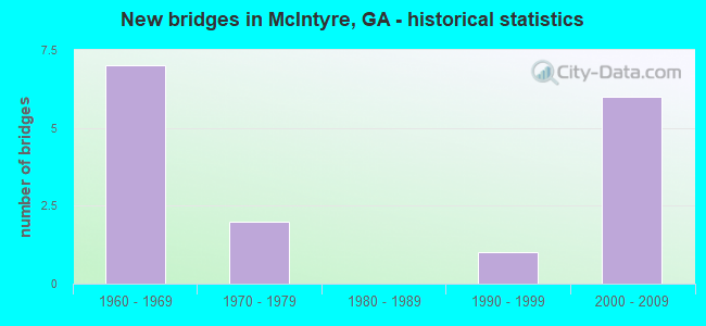
- New bridges - historical statistics
- 71960-1969
- 21970-1979
- 11990-1999
- 62000-2009

- Reconstructed bridges - Historical Statistics
- 11950-1959
- 01960-1969
- 01970-1979
- 01980-1989
- 11990-1999


- Bridge Condition - Deck
- 45.5%Good
- 54.5%Satisfactory

- Bridge Condition - Superstructure
- 9.1%Very good
- 36.4%Good
- 54.5%Satisfactory

- Bridge Condition - Substructure
- 45.5%Good
- 36.4%Poor
- 9.1%Critical
- 9.1%Imminent failure

- Bridge Condition - Channel
- 42.9%Very good
- 28.6%Good
- 21.4%Satisfactory
- 7.1%Fair

- Bridge Condition - Culverts
- 60.0%Good
- 40.0%Satisfactory
Find on map >> Show street view
Structure Number: 3190012, Location: 1 MI N OF MCINTYRE (Lat: 32.858089, Lng: -83.191719), Route carried "on" structure: US 441, Year Built: 1961, Year Reconstructed: 1999, Status: Open, Structure Length: 0.70m (2.30ft), Average Daily Traffic: 4,060 (year 2012), Truck Traffic: 17%, Average Future Daily Traffic: 6,090 (year 2032), Design Load: HS 20+Mod, Features Intersected: COMMISSIONER CREEK TRIB
Minimum Vertical Clearance: 30+ m (98+ ft), Kilometerpoint: 28.968, Lanes on structure: 4, Base Highway Network: Yes, Owner: State Highway Agency, Approaching Roadway Width: 25.0m (82.0ft), Skew: 10 degrees, Material/Design: Concrete, Design/Construction: Culvert, Number Of Spans In Main Unit: 3, Length of Maximum Span: 2.1m (6.9ft)
Condition: Channel: Very good, Culverts: Good, Operating Rating: 89.8 metric tons, Method Used To Determine Operating Rating: Field evaluation and documented engineering judgment, Inventory Rating: 89.8 metric tons, Method Used To Determine Inventory Rating: Field evaluation and documented engineering judgment, Structural Evaluation: Better than present minimum criteria, Waterway Adequacy: Equal to present desirable criteria, Approach Roadway Alignment: Equal to present desirable criteria, Designated Inspection Frequency: Every 24 months, Inspection Date: January 2022, Bridge Improvement Cost: $139,000, Roadway Improvement Cost: $14,000, Total Project Cost: $208,000
Find on map >> Show street view
Structure Number: 3190039, Location: 4 MI W OF IRWINTON (Lat: 32.799469, Lng: -83.241797), Route carried "on" structure: County highway 2099, Year Built: 1970, Status: Open, Structure Length: 0.73m (2.40ft), Average Daily Traffic: 280 (year 2012), Truck Traffic: 1%, Average Future Daily Traffic: 420 (year 2032), Design Load: H 15, Features Intersected: COW PEN CREEK, Facility Carried by Structure: ASBURY CHURCH ROAD
Minimum Vertical Clearance: 30+ m (98+ ft), Kilometerpoint: 11.265, Lanes on structure: 2, Base Highway Network: Yes, Owner: County Highway Agency, Approaching Roadway Width: 7.0m (23.0ft), Skew: 2 degrees, Material/Design: Concrete, Design/Construction: Culvert, Number Of Spans In Main Unit: 2, Length of Maximum Span: 3.4m (11.2ft)
Condition: Channel: Satisfactory, Culverts: Satisfactory, Operating Rating: 41.7 metric tons, Method Used To Determine Operating Rating: Field evaluation and documented engineering judgment, Inventory Rating: 24.4 metric tons, Method Used To Determine Inventory Rating: Field evaluation and documented engineering judgment, Structural Evaluation: Equal to present minimum criteria, Waterway Adequacy: Equal to present desirable criteria, Approach Roadway Alignment: Equal to present desirable criteria, Designated Inspection Frequency: Every 24 months, Inspection Date: Febuary 2022, Bridge Improvement Cost: $94,000, Roadway Improvement Cost: $9,000, Total Project Cost: $141,000
Find on map >> Show street view
Structure Number: 3195009, Location: 1.9 MI NW OF MCINTYRE (Lat: 32.856200, Lng: -83.224931), Route carried "on" structure: County highway 183, Year Built: 1977, Status: Temporarily open, Structure Length: 4.27m (14.01ft), Average Daily Traffic: 490 (year 2012), Truck Traffic: 1%, Average Future Daily Traffic: 735 (year 2032), Design Load: H 15, Features Intersected: LITTLE COMMISSIONER CR, Facility Carried by Structure: GORDON-McINTYRE RD
Minimum Vertical Clearance: 30+ m (98+ ft), Kilometerpoint: 3.219, Lanes on structure: 2, Base Highway Network: Yes, Owner: County Highway Agency, Approaching Roadway Width: 7.0m (23.0ft), Material/Design: Prestressed concrete, Design/Construction: Channel Beam, Number Of Spans In Main Unit: 7, Length of Maximum Span: 6.1m (20.0ft), Curb or Sidewalk Widths: Left: 0.2m (0.7ft), Right: 0.2m (0.7ft), Curb-To-Curb Width: 7.3m (24.0ft), Out-to-Out Width: 7.6m (24.9ft)
Condition: Deck: Satisfactory, Superstructure: Satisfactory, Substructure: Poor, Channel: Fair, Operating Rating: 33.5 metric tons, Method Used To Determine Operating Rating: Load Factor (LF), Inventory Rating: 23.5 metric tons, Method Used To Determine Inventory Rating: Load Factor (LF), Structural Evaluation: Meets minimum limits, Deck Geometry: Meets minimum limits, Waterway Adequacy: Better than present minimum criteria, Approach Roadway Alignment: Better than present minimum criteria, Length Of Structure Improvement: 44.59m (146.29ft), Designated Inspection Frequency: Every 24 months, Underwater Inspection Frequency: Every 60 months, Inspection Date: January 2022, Underwater Inspection Date: May 2018, Bridge Improvement Cost: $547,000, Roadway Improvement Cost: $55,000, Total Project Cost: $821,000, Deck Structure Type: Concrete Precast Panels
Find on map >> Show street view
Structure Number: 319501, Location: 2.1 MI E OF MCINTYRE (Lat: 32.850919, Lng: -83.156278), Route carried "on" structure: County highway 153, Year Built: 1963, Status: Posted for load, Structure Length: 1.95m (6.40ft), Average Daily Traffic: 490 (year 2012), Truck Traffic: 1%, Average Future Daily Traffic: 735 (year 2032), Design Load: H 15, Features Intersected: COMMISSIONER CREEK TRIB., Facility Carried by Structure: WRILEY ROAD
Minimum Vertical Clearance: 30+ m (98+ ft), Kilometerpoint: 4.828, Lanes on structure: 2, Base Highway Network: Yes, Owner: County Highway Agency, Approaching Roadway Width: 5.5m (18.0ft), Material/Design: Steel, Design/Construction: Stringer/Multi-beam, Number Of Spans In Main Unit: 4, Length of Maximum Span: 4.9m (16.1ft), Curb-To-Curb Width: 7.3m (24.0ft), Out-to-Out Width: 7.6m (24.9ft)
Condition: Deck: Satisfactory, Superstructure: Satisfactory, Substructure: Poor, Channel: Good, Operating Rating: 43.5 metric tons, Method Used To Determine Operating Rating: Load Factor (LF), Inventory Rating: 26.3 metric tons, Method Used To Determine Inventory Rating: Load Factor (LF), Structural Evaluation: Meets minimum limits, Deck Geometry: Meets minimum limits, Waterway Adequacy: Better than present minimum criteria, Approach Roadway Alignment: Equal to present minimum criteria, Length Of Structure Improvement: 42.18m (138.39ft), Designated Inspection Frequency: Every 24 months, Underwater Inspection Frequency: Every 60 months, Inspection Date: January 2022, Underwater Inspection Date: May 2018, Bridge Improvement Cost: $250,000, Roadway Improvement Cost: $25,000, Total Project Cost: $375,000, Deck Structure Type: Concrete Cast-file-Place
Find on map >> Show street view
Structure Number: 3195011, Location: 2.2 MI E OF MCINTYRE (Lat: 32.851508, Lng: -83.155500), Route carried "on" structure: County highway 153, Year Built: 1963, Year Reconstructed: 1964, Status: Closed, Structure Length: 6.83m (22.41ft), Average Daily Traffic: 490 (year 2012), Truck Traffic: 1%, Average Future Daily Traffic: 735 (year 2032), Design Load: H 15, Features Intersected: COMMISSIONER CREEK TRIB., Facility Carried by Structure: WRILEY ROAD
Minimum Vertical Clearance: 30+ m (98+ ft), Kilometerpoint: 4.828, Lanes on structure: 2, Base Highway Network: Yes, Owner: County Highway Agency, Approaching Roadway Width: 5.5m (18.0ft), Material/Design: Steel, Design/Construction: Stringer/Multi-beam, Number Of Spans In Main Unit: 14, Length of Maximum Span: 4.9m (16.1ft), Curb-To-Curb Width: 7.3m (24.0ft), Out-to-Out Width: 7.6m (24.9ft)
Condition: Deck: Satisfactory, Superstructure: Satisfactory, Substructure: Imminent failure, Channel: Satisfactory, Deck Geometry: Meets minimum limits, Waterway Adequacy: Better than present minimum criteria, Approach Roadway Alignment: Better than present minimum criteria, Bridge Posting: Required (Relationship of Operating Rating to Maximum Legal Load: > 39.9% below), Length Of Structure Improvement: 47.06m (154.40ft), Designated Inspection Frequency: Every 24 months, Underwater Inspection Frequency: Every 60 months, Other Special Inspection Frequency: Every 6 months, Inspection Date: January 2022, Underwater Inspection Date: May 2018, Other Special Inspection Date: Febuary 2022, Bridge Improvement Cost: $875,000, Roadway Improvement Cost: $88,000, Total Project Cost: $1,313,000, Deck Structure Type: Concrete Cast-file-Place
Find on map >> Show street view
Structure Number: 3195012, Location: 2.3 MI E OF MCINTYRE (Lat: 32.852289, Lng: -83.154419), Route carried "on" structure: County highway 153, Year Built: 1963, Status: Posted for load, Structure Length: 3.41m (11.19ft), Average Daily Traffic: 490 (year 2012), Truck Traffic: 1%, Average Future Daily Traffic: 735 (year 2032), Design Load: H 15, Features Intersected: COMMISSIONER CREEK, Facility Carried by Structure: WRILEY ROAD
Minimum Vertical Clearance: 30+ m (98+ ft), Kilometerpoint: 4.828, Lanes on structure: 2, Base Highway Network: Yes, Owner: County Highway Agency, Approaching Roadway Width: 5.5m (18.0ft), Material/Design: Steel, Design/Construction: Stringer/Multi-beam, Number Of Spans In Main Unit: 7, Length of Maximum Span: 4.9m (16.1ft), Curb-To-Curb Width: 7.3m (24.0ft), Out-to-Out Width: 7.6m (24.9ft)
Condition: Deck: Satisfactory, Superstructure: Satisfactory, Substructure: Poor, Channel: Good, Operating Rating: 36.2 metric tons, Method Used To Determine Operating Rating: Load Factor (LF), Inventory Rating: 21.7 metric tons, Method Used To Determine Inventory Rating: Load Factor (LF), Structural Evaluation: Meets minimum limits, Deck Geometry: Meets minimum limits, Waterway Adequacy: Better than present minimum criteria, Approach Roadway Alignment: Somewhat better than minimum adequacy, Length Of Structure Improvement: 43.65m (143.21ft), Designated Inspection Frequency: Every 24 months, Underwater Inspection Frequency: Every 60 months, Inspection Date: January 2022, Underwater Inspection Date: May 2018, Bridge Improvement Cost: $438,000, Roadway Improvement Cost: $44,000, Total Project Cost: $656,000, Deck Structure Type: Concrete Cast-file-Place
Find on map >> Show street view
Structure Number: 3195014, Location: 3.4 MI NW OF MCINTYRE (Lat: 32.880108, Lng: -83.233908), Route carried "on" structure: County highway 194, Year Built: 1965, Status: Posted for load, Structure Length: 3.05m (10.01ft), Average Daily Traffic: 490 (year 2012), Truck Traffic: 10%, Average Future Daily Traffic: 735 (year 2032), Design Load: H 10, Features Intersected: COMMISSIONER CREEK O/F, Facility Carried by Structure: E.H. SNOW ROAD
Minimum Vertical Clearance: 30+ m (98+ ft), Kilometerpoint: 1.609, Lanes on structure: 2, Base Highway Network: Yes, Owner: County Highway Agency, Approaching Roadway Width: 7.0m (23.0ft), Material/Design: Concrete, Design/Construction: Slab, Number Of Spans In Main Unit: 5, Length of Maximum Span: 6.1m (20.0ft), Curb-To-Curb Width: 7.3m (24.0ft), Out-to-Out Width: 7.7m (25.3ft)
Condition: Deck: Satisfactory, Superstructure: Satisfactory, Substructure: Poor, Channel: Good, Operating Rating: 15.4 metric tons, Method Used To Determine Operating Rating: Allowable Stress (AS), Inventory Rating: 9.0 metric tons, Method Used To Determine Inventory Rating: Allowable Stress (AS), Structural Evaluation: High priority of replacement, Deck Geometry: Meets minimum limits, Waterway Adequacy: Equal to present desirable criteria, Approach Roadway Alignment: Equal to present desirable criteria, Bridge Posting: Required (Relationship of Operating Rating to Maximum Legal Load: > 39.9% below), Length Of Structure Improvement: 43.28m (141.99ft), Designated Inspection Frequency: Every 24 months, Inspection Date: January 2022, Bridge Improvement Cost: $391,000, Roadway Improvement Cost: $39,000, Total Project Cost: $586,000, Deck Structure Type: Concrete Precast Panels
Find on map >> Show street view
Structure Number: 3195015, Location: 3.3 MI NW OF MCINTYRE (Lat: 32.880639, Lng: -83.232808), Route carried "on" structure: County highway 194, Year Built: 1965, Status: Posted for load, Structure Length: 6.10m (20.01ft), Average Daily Traffic: 490 (year 2012), Truck Traffic: 10%, Average Future Daily Traffic: 735 (year 2032), Design Load: H 10, Features Intersected: COMMISSIONER CREEK, Facility Carried by Structure: E.H. SNOW ROAD
Minimum Vertical Clearance: 30+ m (98+ ft), Kilometerpoint: 1.609, Lanes on structure: 2, Base Highway Network: Yes, Owner: County Highway Agency, Approaching Roadway Width: 6.7m (22.0ft), Material/Design: Concrete, Design/Construction: Slab, Number Of Spans In Main Unit: 10, Length of Maximum Span: 6.1m (20.0ft), Curb-To-Curb Width: 7.3m (24.0ft), Out-to-Out Width: 7.7m (25.3ft)
Condition: Deck: Satisfactory, Superstructure: Satisfactory, Substructure: Critical, Channel: Good, Operating Rating: 37.1 metric tons, Method Used To Determine Operating Rating: Field evaluation and documented engineering judgment, Inventory Rating: 25.4 metric tons, Method Used To Determine Inventory Rating: Field evaluation and documented engineering judgment, Structural Evaluation: High priority of replacement, Deck Geometry: Meets minimum limits, Waterway Adequacy: Equal to present desirable criteria, Approach Roadway Alignment: Equal to present desirable criteria, Bridge Posting: Required (Relationship of Operating Rating to Maximum Legal Load: > 39.9% below), Length Of Structure Improvement: 46.33m (152.00ft), Designated Inspection Frequency: Every 24 months, Underwater Inspection Frequency: Every 60 months, Inspection Date: January 2022, Underwater Inspection Date: May 2018, Bridge Improvement Cost: $781,000, Roadway Improvement Cost: $78,000, Total Project Cost: $1,172,000, Deck Structure Type: Concrete Precast Panels
Find on map >> Show street view
Structure Number: 3195016, Location: 3.4 MI NW OF MCINTYRE (Lat: 32.855100, Lng: -83.251458), Route carried "on" structure: County highway 60, Year Built: 1994, Status: Open, Structure Length: 0.88m (2.89ft), Average Daily Traffic: 490 (year 2012), Truck Traffic: 1%, Average Future Daily Traffic: 735 (year 2032), Design Load: HS 20+Mod, Features Intersected: LITTLE COMMISSIONER CR, Facility Carried by Structure: CLAYFIELD ROAD
Minimum Vertical Clearance: 30+ m (98+ ft), Kilometerpoint: 1.609, Lanes on structure: 2, Base Highway Network: Yes, Owner: County Highway Agency, Approaching Roadway Width: 6.1m (20.0ft), Material/Design: Concrete, Design/Construction: Culvert, Number Of Spans In Main Unit: 3, Length of Maximum Span: 2.7m (8.9ft)
Condition: Channel: Very good, Culverts: Good, Operating Rating: 55.3 metric tons, Method Used To Determine Operating Rating: Field evaluation and documented engineering judgment, Inventory Rating: 32.6 metric tons, Method Used To Determine Inventory Rating: Field evaluation and documented engineering judgment, Structural Evaluation: Better than present minimum criteria, Waterway Adequacy: Equal to present desirable criteria, Approach Roadway Alignment: Equal to present desirable criteria, Designated Inspection Frequency: Every 24 months, Inspection Date: January 2022, Bridge Improvement Cost: $113,000, Roadway Improvement Cost: $11,000, Total Project Cost: $170,000
Find on map >> Show street view
Structure Number: 3195017, Location: 2.7 MI NE OF MCINTYRE (Lat: 32.866358, Lng: -83.154358), Route carried "on" structure: County highway 190, Year Built: 1963, Status: Open, Structure Length: 0.82m (2.69ft), Average Daily Traffic: 490 (year 2012), Truck Traffic: 1%, Average Future Daily Traffic: 735 (year 2032), Design Load: H 15, Features Intersected: DRY BRANCH, Facility Carried by Structure: LIBERTY CHURCH RD
Minimum Vertical Clearance: 30+ m (98+ ft), Kilometerpoint: 6.437, Lanes on structure: 2, Base Highway Network: Yes, Owner: County Highway Agency, Approaching Roadway Width: 6.1m (20.0ft), Skew: 1 degrees, Material/Design: Concrete, Design/Construction: Culvert, Number Of Spans In Main Unit: 3, Length of Maximum Span: 2.1m (6.9ft)
Condition: Channel: Satisfactory, Culverts: Satisfactory, Operating Rating: 41.7 metric tons, Method Used To Determine Operating Rating: Field evaluation and documented engineering judgment, Inventory Rating: 24.4 metric tons, Method Used To Determine Inventory Rating: Field evaluation and documented engineering judgment, Structural Evaluation: Equal to present minimum criteria, Waterway Adequacy: Equal to present desirable criteria, Approach Roadway Alignment: Equal to present desirable criteria, Designated Inspection Frequency: Every 24 months, Inspection Date: January 2022, Bridge Improvement Cost: $105,000, Roadway Improvement Cost: $11,000, Total Project Cost: $158,000
Find on map >> Show street view
Structure Number: 319502, Location: 7.5 MI N OF MCINTYRE (Lat: 32.958278, Lng: -83.208819), Route carried "on" structure: US 441, Year Built: 2000, Status: Open, Structure Length: 4.88m (16.01ft), Average Daily Traffic: 4,270 (year 2012), Truck Traffic: 1%, Average Future Daily Traffic: 6,405 (year 2032), Design Load: HS 20+Mod, Features Intersected: BLACK CREEK
Minimum Vertical Clearance: 30+ m (98+ ft), Kilometerpoint: 40.234, Lanes on structure: 2, Base Highway Network: Yes, Owner: State Highway Agency, Approaching Roadway Width: 12.2m (40.0ft), Skew: 13 degrees, Material/Design: Prestressed concrete, Design/Construction: Stringer/Multi-beam, Number Of Spans In Main Unit: 4, Length of Maximum Span: 12.2m (40.0ft), Curb-To-Curb Width: 11.6m (38.1ft), Out-to-Out Width: 12.6m (41.3ft)
Condition: Deck: Good, Superstructure: Good, Substructure: Good, Channel: Very good, Operating Rating: 51.7 metric tons, Method Used To Determine Operating Rating: Allowable Stress (AS), Inventory Rating: 32.6 metric tons, Method Used To Determine Inventory Rating: Allowable Stress (AS), Structural Evaluation: Better than present minimum criteria, Deck Geometry: Somewhat better than minimum adequacy, Waterway Adequacy: Equal to present desirable criteria, Approach Roadway Alignment: Equal to present desirable criteria, Designated Inspection Frequency: Every 24 months, Inspection Date: January 2022, Bridge Improvement Cost: $625,000, Roadway Improvement Cost: $63,000, Total Project Cost: $938,000, Deck Structure Type: Concrete Cast-file-Place
Find on map >> Show street view
Structure Number: 3195022, Location: IN THE CITY OF MCINTYRE (Lat: 32.846189, Lng: -83.192069), Route carried "on" structure: US 441, Year Built: 2001, Status: Open, Structure Length: 9.54m (31.30ft), Average Daily Traffic: 4,350 (year 2012), Truck Traffic: 1%, Average Future Daily Traffic: 6,525 (year 2032), Design Load: HS 20+Mod, Features Intersected: CS 71 & NOR - SOU R/R
Minimum Vertical Clearance: 30+ m (98+ ft), Kilometerpoint: 25.750, Lanes on structure: 2, Lanes under structure: 2, Base Highway Network: Yes, Owner: State Highway Agency, Approaching Roadway Width: 9.1m (29.9ft), Skew: 12 degrees, Material/Design: Prestressed concrete, Design/Construction: Stringer/Multi-beam, Number Of Spans In Main Unit: 4, Length of Maximum Span: 27.4m (89.9ft), Curb-To-Curb Width: 11.6m (38.1ft), Out-to-Out Width: 12.8m (42.0ft)
Condition: Deck: Good, Superstructure: Good, Substructure: Good, Operating Rating: 62.5 metric tons, Method Used To Determine Operating Rating: Load Factor (LF), Inventory Rating: 37.1 metric tons, Method Used To Determine Inventory Rating: Load Factor (LF), Structural Evaluation: Better than present minimum criteria, Deck Geometry: Better than present minimum criteria, Underclear: Meets minimum limits, Approach Roadway Alignment: Equal to present desirable criteria, Designated Inspection Frequency: Every 24 months, Inspection Date: January 2022, Bridge Improvement Cost: $1,223,000, Roadway Improvement Cost: $122,000, Total Project Cost: $1,834,000, Deck Structure Type: Concrete Cast-file-Place
Find on map >> Show street view
Structure Number: 3195023, Location: IN THE CITY OF MCINTYRE (Lat: 32.846231, Lng: -83.192350), Route carried "on" structure: US 441, Year Built: 2001, Status: Open, Structure Length: 9.54m (31.30ft), Average Daily Traffic: 4,350 (year 2012), Truck Traffic: 1%, Average Future Daily Traffic: 6,525 (year 2032), Design Load: HS 20+Mod, Features Intersected: CS 71 & NOR - SOU R/R
Minimum Vertical Clearance: 30+ m (98+ ft), Kilometerpoint: 25.750, Lanes on structure: 2, Lanes under structure: 2, Base Highway Network: Yes, Owner: State Highway Agency, Approaching Roadway Width: 9.1m (29.9ft), Skew: 12 degrees, Material/Design: Prestressed concrete, Design/Construction: Stringer/Multi-beam, Number Of Spans In Main Unit: 4, Length of Maximum Span: 27.4m (89.9ft), Curb-To-Curb Width: 11.6m (38.1ft), Out-to-Out Width: 12.8m (42.0ft)
Condition: Deck: Good, Superstructure: Good, Substructure: Good, Operating Rating: 65.3 metric tons, Method Used To Determine Operating Rating: Load Factor (LF), Inventory Rating: 39.0 metric tons, Method Used To Determine Inventory Rating: Load Factor (LF), Structural Evaluation: Better than present minimum criteria, Deck Geometry: Better than present minimum criteria, Underclear: Meets minimum limits, Approach Roadway Alignment: Equal to present desirable criteria, Designated Inspection Frequency: Every 24 months, Inspection Date: January 2022, Bridge Improvement Cost: $1,223,000, Roadway Improvement Cost: $122,000, Total Project Cost: $1,834,000, Deck Structure Type: Concrete Cast-file-Place
Find on map >> Show street view
Structure Number: 3195024, Location: IN THE CITY OF MCINTYRE (Lat: 32.850219, Lng: -83.193100), Route carried "on" structure: US 441, Year Built: 2001, Status: Open, Structure Length: 29.26m (96.00ft), Average Daily Traffic: 4,060 (year 2012), Truck Traffic: 17%, Average Future Daily Traffic: 6,090 (year 2032), Design Load: HS 20+Mod, Features Intersected: COMMISSIONERS CREEK
Minimum Vertical Clearance: 30+ m (98+ ft), Kilometerpoint: 25.750, Lanes on structure: 2, Base Highway Network: Yes, Owner: State Highway Agency, Approaching Roadway Width: 14.6m (47.9ft), Skew: 11 degrees, Material/Design: Prestressed concrete, Design/Construction: Stringer/Multi-beam, Number Of Spans In Main Unit: 22, Length of Maximum Span: 36.6m (120.1ft), Curb-To-Curb Width: 11.6m (38.1ft), Out-to-Out Width: 12.6m (41.3ft)
Condition: Deck: Good, Superstructure: Very good, Substructure: Good, Channel: Very good, Operating Rating: 74.3 metric tons, Method Used To Determine Operating Rating: Load Factor (LF), Inventory Rating: 40.8 metric tons, Method Used To Determine Inventory Rating: Load Factor (LF), Structural Evaluation: Better than present minimum criteria, Deck Geometry: Better than present minimum criteria, Waterway Adequacy: Equal to present desirable criteria, Approach Roadway Alignment: Equal to present desirable criteria, Designated Inspection Frequency: Every 24 months, Inspection Date: January 2022, Bridge Improvement Cost: $3,751,000, Roadway Improvement Cost: $375,000, Total Project Cost: $5,626,000, Deck Structure Type: Concrete Cast-file-Place
Find on map >> Show street view
Structure Number: 3195025, Location: IN THE CITY OF MCINTYRE (Lat: 32.850269, Lng: -83.193369), Route carried "on" structure: US 441, Year Built: 2001, Status: Open, Structure Length: 29.26m (96.00ft), Average Daily Traffic: 4,060 (year 2012), Truck Traffic: 17%, Average Future Daily Traffic: 6,090 (year 2032), Design Load: HS 20+Mod, Features Intersected: COMMISSIONERS CREEK
Minimum Vertical Clearance: 30+ m (98+ ft), Kilometerpoint: 25.750, Lanes on structure: 2, Base Highway Network: Yes, Owner: State Highway Agency, Approaching Roadway Width: 12.5m (41.0ft), Skew: 11 degrees, Material/Design: Prestressed concrete, Design/Construction: Stringer/Multi-beam, Number Of Spans In Main Unit: 22, Length of Maximum Span: 36.6m (120.1ft), Curb-To-Curb Width: 11.6m (38.1ft), Out-to-Out Width: 12.6m (41.3ft)
Condition: Deck: Good, Superstructure: Good, Substructure: Good, Channel: Very good, Operating Rating: 74.3 metric tons, Method Used To Determine Operating Rating: Load Factor (LF), Inventory Rating: 40.8 metric tons, Method Used To Determine Inventory Rating: Load Factor (LF), Structural Evaluation: Better than present minimum criteria, Deck Geometry: Better than present minimum criteria, Waterway Adequacy: Equal to present desirable criteria, Approach Roadway Alignment: Equal to present desirable criteria, Designated Inspection Frequency: Every 24 months, Inspection Date: January 2022, Bridge Improvement Cost: $3,751,000, Roadway Improvement Cost: $375,000, Total Project Cost: $5,626,000, Deck Structure Type: Concrete Cast-file-Place
Find on map >> Show street view
Structure Number: 3195031, Location: 2.7 MI EAST OF MCINTYRE (Lat: 32.853369, Lng: -83.145208), Route carried "on" structure: County highway 146, Year Built: 2007, Status: Open, Structure Length: 0.70m (2.30ft), Average Daily Traffic: 50 (year 2012), Truck Traffic: 1%, Average Future Daily Traffic: 75 (year 2032), Design Load: HS 20+Mod, Features Intersected: DRY BRANCH, Facility Carried by Structure: DENT RD
Minimum Vertical Clearance: 30+ m (98+ ft), Kilometerpoint: 1.609, Lanes on structure: 2, Base Highway Network: Yes, Owner: County Highway Agency, Approaching Roadway Width: 7.9m (25.9ft), Material/Design: Concrete, Design/Construction: Culvert, Number Of Spans In Main Unit: 3, Length of Maximum Span: 2.1m (6.9ft)
Condition: Channel: Very good, Culverts: Good, Operating Rating: 55.3 metric tons, Method Used To Determine Operating Rating: Field evaluation and documented engineering judgment, Inventory Rating: 32.6 metric tons, Method Used To Determine Inventory Rating: Field evaluation and documented engineering judgment, Structural Evaluation: Better than present minimum criteria, Waterway Adequacy: Equal to present desirable criteria, Approach Roadway Alignment: Equal to present desirable criteria, Designated Inspection Frequency: Every 24 months, Inspection Date: January 2022, Bridge Improvement Cost: $90,000, Roadway Improvement Cost: $9,000, Total Project Cost: $135,000
Find on map >> Show street view
Structure Number: 3195022, Location: IN THE CITY OF MCINTYRE (Lat: 32.846189, Lng: -83.192069), Route carried "under" structure: City street 71, Structure Length: 0. m, Average Daily Traffic: 1,300 (year 2000), Truck Traffic: 1%, Features Intersected: SR 29 (US 441), Facility Carried by Structure: US 441 (NBL) / SR
Minimum Vertical Clearance: 7.46m (24.48ft), Kilometerpoint: 0.000, Lanes on structure: 2, Length of Maximum Span: 0.0m
Find on map >> Show street view
Structure Number: 3195023, Location: IN THE CITY OF MCINTYRE (Lat: 32.846231, Lng: -83.192350), Route carried "under" structure: City street 71, Structure Length: 0. m, Average Daily Traffic: 1,300 (year 1998), Truck Traffic: 1%, Features Intersected: SR 29 (US 441), Facility Carried by Structure: US 441 (SBL)/SR 29
Minimum Vertical Clearance: 7.82m (25.66ft), Kilometerpoint: 0.000, Lanes on structure: 2, Length of Maximum Span: 0.0m