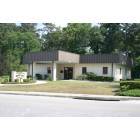
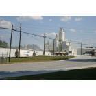
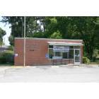
McIntyre, Georgia
Submit your own pictures of this town and show them to the world
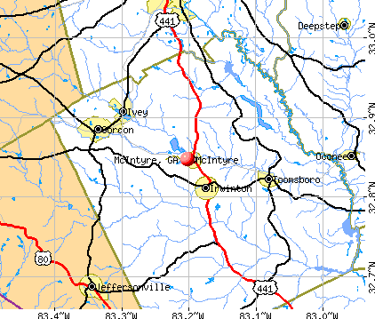
- OSM Map
- General Map
- Google Map
- MSN Map
Population change since 2000: -21.9%
 |
| Males: 205 | |
| Females: 356 |
| Median resident age: | 39.5 years |
| Georgia median age: | 37.6 years |
Zip codes: 31054.
| McIntyre: | $50,807 |
| GA: | $72,837 |
Estimated per capita income in 2022: $23,986 (it was $11,485 in 2000)
McIntyre town income, earnings, and wages data
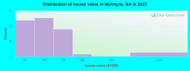
Estimated median house or condo value in 2022: $102,439 (it was $41,700 in 2000)
| McIntyre: | $102,439 |
| GA: | $297,400 |
Mean prices in 2022: all housing units: $92,156; detached houses: $95,902; mobile homes: $51,966
Median gross rent in 2022: $789.
(13.4% for White Non-Hispanic residents, 15.3% for Black residents, 55.7% for Hispanic or Latino residents)
Detailed information about poverty and poor residents in McIntyre, GA
Compare current foreclosures near McIntyre, GA:
| Photo | Address | Area | Beds / Baths | Price | Details |
|---|---|---|---|---|---|

|
#1
Kaolin Heights Rd
Dry Branch, GA 31020
|
1,028 sq. feet
|
1 baths 3 beds |
$165,000
|
show details |

|
#2
Harmony Church Rd
Sandersville, GA 31082
|
2,128 sq. feet
|
2 baths 3 beds |
show details | |

|
#3
Forest Valley Dr
Gordon, GA 31031
|
1,752 sq. feet
|
2 baths 3 beds |
show details | |

|
#4
Stembridge Rd SE # A
Milledgeville, GA 31061
|
1,216 sq. feet
|
2 baths 2 beds |
show details | |

|
#5
Old Colony Farm Rd SW
Milledgeville, GA 31061
|
1,728 sq. feet
|
2 baths 3 beds |
show details | |

|
#6
Kings Rd SE
Milledgeville, GA 31061
|
1,658 sq. feet
|
1 baths 2 beds |
show details | |

|
#7
College St
Gordon, GA 31031
|
1,848 sq. feet
|
2 baths 3 beds |
show details | |

|
#8
Youngblood Rd SE
Milledgeville, GA 31061
|
1,424 sq. feet
|
1 baths 3 beds |
show details | |

|
#9
Ebony Lounge Rd NE
Milledgeville, GA 31061
|
2,016 sq. feet
|
2 baths 4 beds |
show details | |

|
#10
Lovers Ln NE
Milledgeville, GA 31061
|
1,716 sq. feet
|
2 baths 3 beds |
show details |
| Photo | Address | Area | Beds / Baths | Price | Details |
|---|---|---|---|---|---|

|
#11
Lilac Dr SE
Milledgeville, GA 31061
|
1,384 sq. feet
|
2 baths - beds |
show details | |

|
#12
Lilac Dr SE
Milledgeville, GA 31061
|
1,510 sq. feet
|
2 baths - beds |
show details | |

|
#13
Irwinton Rd
Milledgeville, GA 31061
|
512 sq. feet
|
1 baths - beds |
show details | |

|
#14
Irwinton Rd # 9
Milledgeville, GA 31061
|
512 sq. feet
|
1 baths - beds |
show details | |

|
#15
Lake Dr # B
Milledgeville, GA 31061
|
1,560 sq. feet
|
2 baths - beds |
show details | |

|
#16
Bethlehem Church Rd
Gordon, GA 31031
|
1,960 sq. feet
|
2 baths - beds |
show details | |

|
#17
Stembridge Rd SE
Milledgeville, GA 31061
|
1,904 sq. feet
|
1 baths - beds |
show details | |

|
#18
Crawford Rd SE
Milledgeville, GA 31061
|
1,672 sq. feet
|
1 baths - beds |
show details | |

|
#19
Ogden Ter SE
Milledgeville, GA 31061
|
1,152 sq. feet
|
1 baths - beds |
show details | |

|
#20
Harrisburg Rd SW
Milledgeville, GA 31061
|
1,129 sq. feet
|
2 baths - beds |
show details |
| Photo | Address | Area | Beds / Baths | Price | Details |
|---|---|---|---|---|---|

|
#21
Perry Dr
Milledgeville, GA 31061
|
1,144 sq. feet
|
1 baths - beds |
show details | |

|
#22
Stembridge Rd SE
Milledgeville, GA 31061
|
1,462 sq. feet
|
1 baths - beds |
show details | |

|
#23
1st St SW
Milledgeville, GA 31061
|
2,020 sq. feet
|
1 baths - beds |
show details | |

|
#24
Felton Dr
Milledgeville, GA 31061
|
1,448 sq. feet
|
2 baths - beds |
show details | |

|
#25
Bonner Dr SW
Milledgeville, GA 31061
|
- sq. feet
|
2 baths 2 beds |
show details | |

|
#26
Park Ave
Milledgeville, GA 31061
|
864 sq. feet
|
1 baths - beds |
show details | |

|
#27
2nd St SW
Milledgeville, GA 31061
|
664 sq. feet
|
1 baths - beds |
show details | |

|
#28
Us Highway 80
Jeffersonville, GA 31044
|
1,040 sq. feet
|
1 baths - beds |
show details | |

|
#29
Youngblood Rd SE
Milledgeville, GA 31061
|
1,274 sq. feet
|
1 baths - beds |
show details | |

|
#30
Stembridge Rd SE
Milledgeville, GA 31061
|
1,800 sq. feet
|
2 baths - beds |
show details |
| Photo | Address | Area | Beds / Baths | Price | Details |
|---|---|---|---|---|---|

|
#31
Stuart Cir SE
Milledgeville, GA 31061
|
1,158 sq. feet
|
1 baths - beds |
show details | |

|
#32
Allen Memorial Dr SW
Milledgeville, GA 31061
|
912 sq. feet
|
1 baths - beds |
show details | |

|
#33
Oak Ave
Milledgeville, GA 31061
|
1,050 sq. feet
|
1 baths - beds |
show details | |

|
#34
Swint Ave SE
Milledgeville, GA 31061
|
1,080 sq. feet
|
1 baths - beds |
show details | |

|
#35
Allen Memorial Dr SW
Milledgeville, GA 31061
|
2,052 sq. feet
|
2 baths - beds |
show details | |

|
#36
Shiloh Church Rd
Jeffersonville, GA 31044
|
1,225 sq. feet
|
2 baths - beds |
show details | |

|
#37
Magnolia Ave SE
Milledgeville, GA 31061
|
2,778 sq. feet
|
3 baths - beds |
show details | |

|
#38
Butler Rd SE
Milledgeville, GA 31061
|
2,643 sq. feet
|
2 baths - beds |
show details | |

|
#39
Irwinton Rd
Milledgeville, GA 31061
|
2,420 sq. feet
|
1 baths - beds |
show details | |

|
#40
Allen Memorial Dr SW
Milledgeville, GA 31061
|
1,529 sq. feet
|
1 baths - beds |
show details |
| Photo | Address | Area | Beds / Baths | Price | Details |
|---|---|---|---|---|---|

|
#41
Rosewood Dr SE
Milledgeville, GA 31061
|
1,066 sq. feet
|
1 baths - beds |
show details | |

|
#42
Torrance Rd SW
Milledgeville, GA 31061
|
1,824 sq. feet
|
2 baths - beds |
show details | |

|
#43
Jf Hall Rd
Gordon, GA 31031
|
840 sq. feet
|
2 baths - beds |
show details | |

|
#44
Eleanor Dr
Gordon, GA 31031
|
1,792 sq. feet
|
2 baths - beds |
show details | |

|
#45
Knob Hill Rd
Gordon, GA 31031
|
1,755 sq. feet
|
2 baths - beds |
show details | |

|
#46
Hidden Hills Dr NW
Milledgeville, GA 31061
|
2,800 sq. feet
|
2 baths - beds |
show details | |

|
#47
Valentine Rd NE
Milledgeville, GA 31061
|
1,248 sq. feet
|
2 baths - beds |
show details | |

|
#48
Lavender Rd
Irwinton, GA 31042
|
1,326 sq. feet
|
1 baths - beds |
show details | |

|
#49
Wriley Rd
Mc Intyre, GA 31054
|
1,656 sq. feet
|
2 baths - beds |
show details | |

|
Check over 1 million property listings on Foreclosure.com!
|
browse all offers | |||


- 49868.2%Black alone
- 13318.2%White alone
- 9212.6%Hispanic
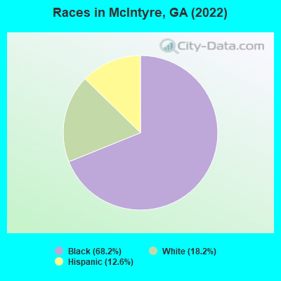
Races in McIntyre detailed stats: ancestries, foreign born residents, place of birth
According to our research of Georgia and other state lists, there were 4 registered sex offenders living in McIntyre, Georgia as of May 22, 2024.
The ratio of all residents to sex offenders in McIntyre is 198 to 1.
Type |
2009 |
2010 |
2011 |
2012 |
2013 |
2014 |
2015 |
2016 |
2017 |
2018 |
2019 |
2020 |
2021 |
2022 |
|---|---|---|---|---|---|---|---|---|---|---|---|---|---|---|
| Murders (per 100,000) | 0 (0.0) | 0 (0.0) | 0 (0.0) | 0 (0.0) | 0 (0.0) | 0 (0.0) | 0 (0.0) | 0 (0.0) | 0 (0.0) | 0 (0.0) | 0 (0.0) | 0 (0.0) | 0 (0.0) | 0 (0.0) |
| Rapes (per 100,000) | 0 (0.0) | 0 (0.0) | 0 (0.0) | 1 (154.1) | 0 (0.0) | 0 (0.0) | 0 (0.0) | 0 (0.0) | 0 (0.0) | 0 (0.0) | 0 (0.0) | 0 (0.0) | 0 (0.0) | 0 (0.0) |
| Robberies (per 100,000) | 0 (0.0) | 1 (153.8) | 0 (0.0) | 1 (154.1) | 0 (0.0) | 0 (0.0) | 0 (0.0) | 0 (0.0) | 0 (0.0) | 0 (0.0) | 0 (0.0) | 0 (0.0) | 0 (0.0) | 0 (0.0) |
| Assaults (per 100,000) | 2 (280.9) | 1 (153.8) | 1 (151.7) | 0 (0.0) | 2 (307.7) | 2 (311.0) | 0 (0.0) | 1 (162.6) | 1 (163.7) | 1 (166.1) | 0 (0.0) | 0 (0.0) | 0 (0.0) | 0 (0.0) |
| Burglaries (per 100,000) | 7 (983.1) | 10 (1,538) | 4 (607.0) | 5 (770.4) | 3 (461.5) | 5 (777.6) | 4 (638.0) | 2 (325.2) | 6 (982.0) | 5 (830.6) | 1 (166.1) | 1 (166.4) | 0 (0.0) | 0 (0.0) |
| Thefts (per 100,000) | 22 (3,090) | 24 (3,692) | 18 (2,731) | 23 (3,544) | 19 (2,923) | 12 (1,866) | 11 (1,754) | 9 (1,463) | 6 (982.0) | 5 (830.6) | 10 (1,661) | 2 (332.8) | 2 (337.3) | 2 (352.1) |
| Auto thefts (per 100,000) | 2 (280.9) | 3 (461.5) | 0 (0.0) | 0 (0.0) | 0 (0.0) | 2 (311.0) | 2 (319.0) | 0 (0.0) | 0 (0.0) | 0 (0.0) | 1 (166.1) | 0 (0.0) | 0 (0.0) | 2 (352.1) |
| Arson (per 100,000) | 0 (0.0) | 0 (0.0) | 0 (0.0) | 0 (0.0) | 0 (0.0) | 0 (0.0) | 0 (0.0) | 0 (0.0) | 0 (0.0) | 0 (0.0) | 0 (0.0) | 0 (0.0) | 0 (0.0) | 0 (0.0) |
| City-Data.com crime index | 271.1 | 369.2 | 182.1 | 365.2 | 210.8 | 216.2 | 140.4 | 113.8 | 140.8 | 124.6 | 91.4 | 25.0 | 13.5 | 42.3 |
The City-Data.com crime index weighs serious crimes and violent crimes more heavily. Higher means more crime, U.S. average is 246.1. It adjusts for the number of visitors and daily workers commuting into cities.
Crime rate in McIntyre detailed stats: murders, rapes, robberies, assaults, burglaries, thefts, arson
Full-time law enforcement employees in 2021, including police officers: 3 (3 officers - 3 male; 0 female).
| Officers per 1,000 residents here: | 5.06 |
| Georgia average: | 2.45 |
 Recent articles from our blog. Our writers, many of them Ph.D. graduates or candidates, create easy-to-read articles on a wide variety of topics.


 | Blackhall Studios will expand movie studios outside of East Atlanta (3 replies) |
| Is McIntyre really a place? (4 replies) |
| Kennesaw Gun Law (103 replies) |
| Serious question: If you could change one thing about Richmond County, what would it be? (25 replies) |
| Here Comes Honey Boo Boo - TLC (67 replies) |
| White flight — to the city (174 replies) |
Latest news from McIntyre, GA collected exclusively by city-data.com from local newspapers, TV, and radio stations
Ancestries: American (8.2%), Irish (7.4%), European (1.9%), Italian (1.9%).
Current Local Time: EST time zone
Elevation: 256 feet
Land area: 5.19 square miles.
Population density: 108 people per square mile (very low).
49 residents are foreign born (6.2% Latin America).
| This town: | 6.7% |
| Georgia: | 10.4% |
Median real estate property taxes paid for housing units with mortgages in 2022: $592 (1.0%)
Median real estate property taxes paid for housing units with no mortgage in 2022: $1,052 (0.9%)
Nearest city with pop. 50,000+: Macon, GA  (25.0 miles , pop. 97,255).
Nearest city with pop. 200,000+: Atlanta, GA (93.8 miles , pop. 416,474).
Nearest city with pop. 1,000,000+: Philadelphia, PA (667.0 miles , pop. 1,517,550).
Nearest cities:
), ), ), Latitude: 32.85 N, Longitude: 83.20 W
Area code commonly used in this area: 478

| Here: | 2.9% |
| Georgia: | 2.9% |
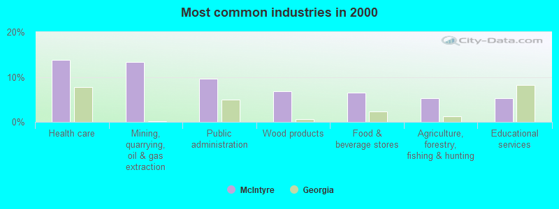
- Health care (13.7%)
- Mining, quarrying, oil & gas extraction (13.4%)
- Public administration (9.5%)
- Wood products (6.9%)
- Food & beverage stores (6.5%)
- Agriculture, forestry, fishing & hunting (5.3%)
- Educational services (5.3%)
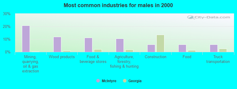
- Mining, quarrying, oil & gas extraction (20.7%)
- Wood products (11.9%)
- Food & beverage stores (11.1%)
- Agriculture, forestry, fishing & hunting (10.4%)
- Construction (5.9%)
- Food (5.9%)
- Truck transportation (5.9%)
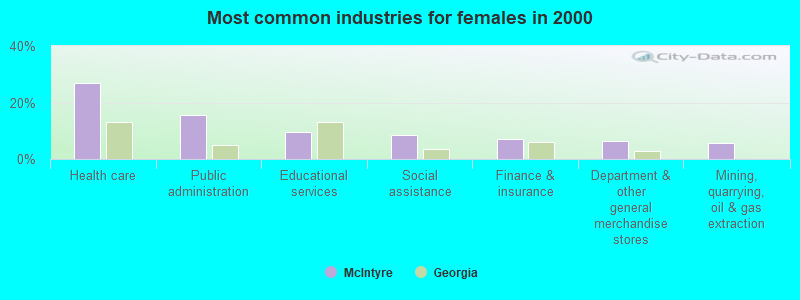
- Health care (26.8%)
- Public administration (15.7%)
- Educational services (9.4%)
- Social assistance (8.7%)
- Finance & insurance (7.1%)
- Department & other general merchandise stores (6.3%)
- Mining, quarrying, oil & gas extraction (5.5%)
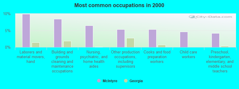
- Laborers and material movers, hand (9.9%)
- Building and grounds cleaning and maintenance occupations (8.4%)
- Nursing, psychiatric, and home health aides (6.5%)
- Other production occupations, including supervisors (5.3%)
- Cooks and food preparation workers (5.3%)
- Child care workers (4.6%)
- Preschool, kindergarten, elementary, and middle school teachers (4.2%)
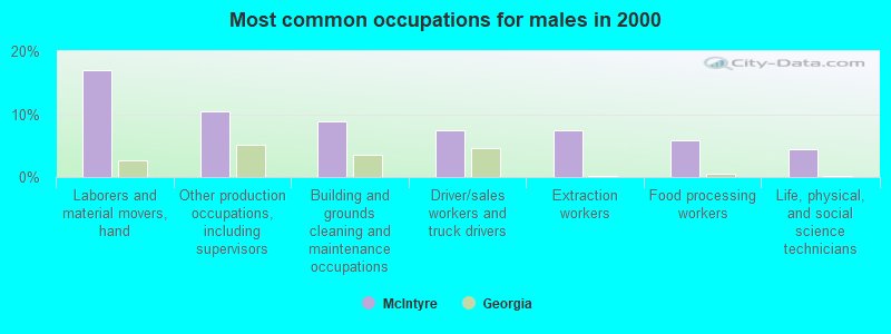
- Laborers and material movers, hand (17.0%)
- Other production occupations, including supervisors (10.4%)
- Building and grounds cleaning and maintenance occupations (8.9%)
- Driver/sales workers and truck drivers (7.4%)
- Extraction workers (7.4%)
- Food processing workers (5.9%)
- Life, physical, and social science technicians (4.4%)
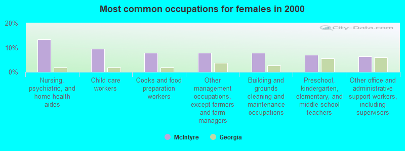
- Nursing, psychiatric, and home health aides (13.4%)
- Child care workers (9.4%)
- Cooks and food preparation workers (7.9%)
- Other management occupations, except farmers and farm managers (7.9%)
- Building and grounds cleaning and maintenance occupations (7.9%)
- Preschool, kindergarten, elementary, and middle school teachers (7.1%)
- Other office and administrative support workers, including supervisors (6.3%)
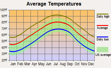
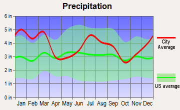
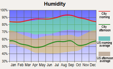
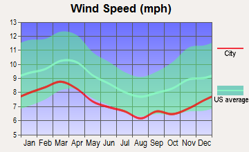
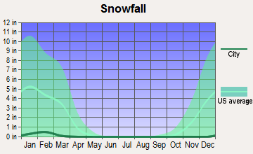
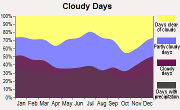
Average climate in McIntyre, Georgia
Based on data reported by over 4,000 weather stations

(lower is better)
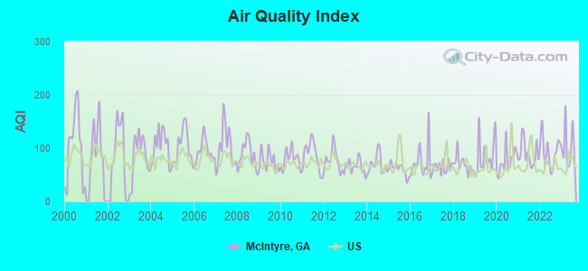
Air Quality Index (AQI) level in 2023 was 102. This is significantly worse than average.
| City: | 102 |
| U.S.: | 73 |
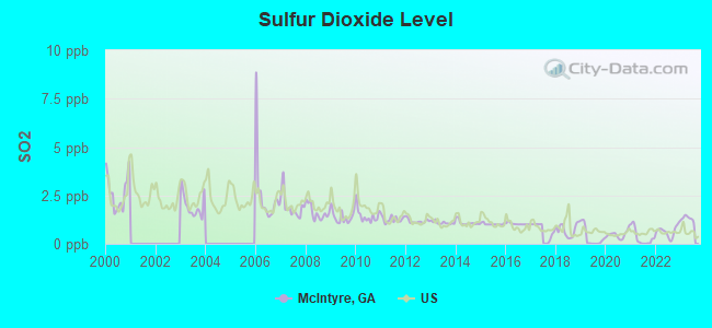
Sulfur Dioxide (SO2) [ppb] level in 2023 was 1.31. This is about average. Closest monitor was 20.1 miles away from the city center.
| City: | 1.31 |
| U.S.: | 1.51 |
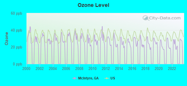
Ozone [ppb] level in 2022 was 23.4. This is significantly better than average. Closest monitor was 20.1 miles away from the city center.
| City: | 23.4 |
| U.S.: | 33.3 |
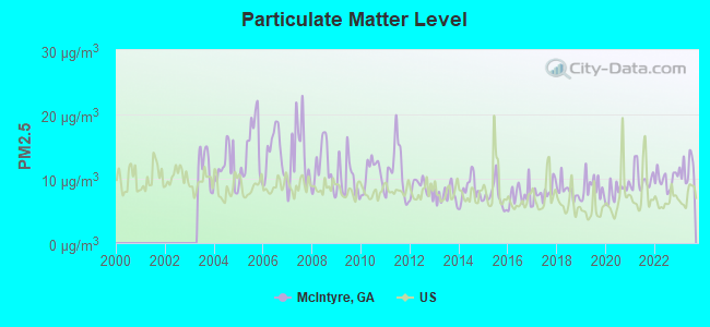
Particulate Matter (PM2.5) [µg/m3] level in 2023 was 11.6. This is significantly worse than average. Closest monitor was 8.0 miles away from the city center.
| City: | 11.6 |
| U.S.: | 8.1 |
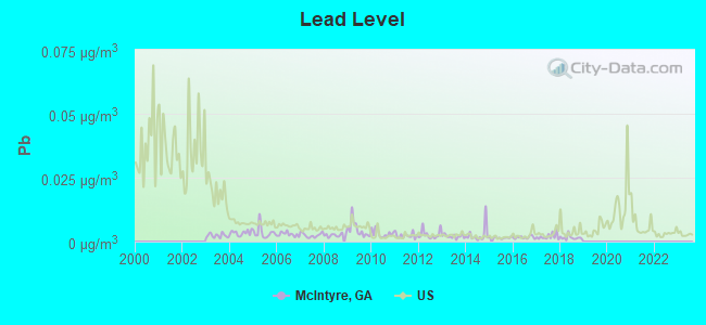
Lead (Pb) [µg/m3] level in 2018 was 0.00153. This is significantly better than average. Closest monitor was 20.1 miles away from the city center.
| City: | 0.00153 |
| U.S.: | 0.00931 |
Tornado activity:
McIntyre-area historical tornado activity is slightly below Georgia state average. It is 4% greater than the overall U.S. average.
On 11/22/1992, a category F4 (max. wind speeds 207-260 mph) tornado 27.1 miles away from the McIntyre town center killed 5 people and injured 86 people and caused between $5,000,000 and $50,000,000 in damages.
On 4/30/1953, a category F4 tornado 28.8 miles away from the town center killed 18 people and injured 300 people and caused between $5,000,000 and $50,000,000 in damages.
Earthquake activity:
McIntyre-area historical earthquake activity is significantly above Georgia state average. It is 0% greater than the overall U.S. average.On 8/2/1974 at 08:52:09, a magnitude 4.9 (4.3 MB, 4.9 LG, Class: Light, Intensity: IV - V) earthquake occurred 82.0 miles away from McIntyre center
On 4/29/2003 at 08:59:39, a magnitude 4.9 (4.4 MB, 4.6 MW, 4.9 LG) earthquake occurred 180.2 miles away from McIntyre center
On 11/22/1974 at 05:25:55, a magnitude 4.7 (4.7 MB) earthquake occurred 177.6 miles away from the city center
On 4/29/2003 at 08:59:39, a magnitude 4.6 (4.6 MW, Depth: 12.3 mi) earthquake occurred 180.3 miles away from McIntyre center
On 8/9/2020 at 12:07:37, a magnitude 5.1 (5.1 MW, Depth: 4.7 mi, Class: Moderate, Intensity: VI - VII) earthquake occurred 278.1 miles away from McIntyre center
On 11/30/1973 at 07:48:41, a magnitude 4.7 (4.7 MB, 4.6 ML) earthquake occurred 208.7 miles away from McIntyre center
Magnitude types: regional Lg-wave magnitude (LG), body-wave magnitude (MB), local magnitude (ML), moment magnitude (MW)
Natural disasters:
The number of natural disasters in Wilkinson County (9) is smaller than the US average (15).Major Disasters (Presidential) Declared: 5
Emergencies Declared: 3
Causes of natural disasters: Storms: 3, Floods: 2, Hurricanes: 2, Tornadoes: 2, Drought: 1, Tropical Storm: 1, Winter Storm: 1, Other: 1 (Note: some incidents may be assigned to more than one category).

Hospitals and medical centers near McIntyre:
- HERITAGE HEALTHCARE OF TOOMSBORO (Nursing Home, about 8 miles away; TOOMSBORO, GA)
- BRIAN CTR NURSING CARE/JEFFERSONVILLE (Nursing Home, about 14 miles away; JEFFERSONVILLE, GA)
- JEFFERSONVILLE NURSING AND REHAB CENTER (Nursing Home, about 14 miles away; JEFFERSONVILLE, GA)
- OCONEE HEALTH AND REHABILITATION (Nursing Home, about 15 miles away; OCONEE, GA)
- OCONEE HEALTH CARE CENTER (Nursing Home, about 15 miles away; OCONEE, GA)
- GREEN ACRES INC (Nursing Home, about 15 miles away; MILLEDGEVILLE, GA)
- CHAPLINWOOD NH (Nursing Home, about 15 miles away; MILLEDGEVILLE, GA)
Colleges/universities with over 2000 students nearest to McIntyre:
- Georgia Military College-Distance Learning Campuses (about 17 miles; Milledgeville, GA; Full-time enrollment: 6,438)
- Georgia College and State University (about 17 miles; Milledgeville, GA; FT enrollment: 6,271)
- Mercer University (about 27 miles; Macon, GA; FT enrollment: 6,297)
- Middle Georgia State College (about 31 miles; Macon, GA; FT enrollment: 7,091)
- Central Georgia Technical College (about 35 miles; Warner Robins, GA; FT enrollment: 6,829)
- Fort Valley State University (about 46 miles; Fort Valley, GA; FT enrollment: 3,200)
- East Georgia State College (about 55 miles; Swainsboro, GA; FT enrollment: 2,345)
Public high school in McIntyre:
Points of interest:
Notable location: McIntyre Volunteer Fire Department (A). Display/hide its location on the map
Churches in McIntyre include: Calvary Church (A), Fountain Grove Church (B). Display/hide their locations on the map
Creek: Little Commissioner Creek (A). Display/hide its location on the map
Birthplace of: Kevin Brown - 2005 Major League Baseball player (New York Yankees, born: Mar 14, 1965), Xavier Whipple - College basketball player (LSU Tigers).
| This town: | 2.6 people |
| Georgia: | 2.6 people |
| This town: | 73.9% |
| Whole state: | 68.5% |
| This town: | 3.6% |
| Whole state: | 5.9% |
Likely homosexual households (counted as self-reported same-sex unmarried-partner households)
- Lesbian couples: 0.4% of all households
- Gay men: 0.0% of all households
For population 15 years and over in McIntyre:
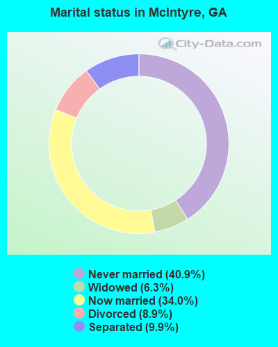
- Never married: 40.9%
- Now married: 34.0%
- Separated: 9.9%
- Widowed: 6.3%
- Divorced: 8.9%
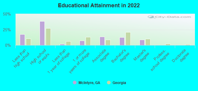
For population 25 years and over in McIntyre:
- High school or higher: 80.6%
- Bachelor's degree or higher: 20.3%
- Graduate or professional degree: 8.3%
- Unemployed: 10.3%
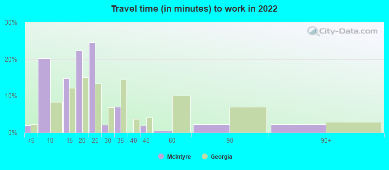
- Mean travel time to work (commute): 20.1 minutes
| Here: | 14.9 |
| Georgia average: | 12.2 |
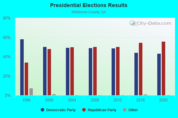
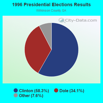
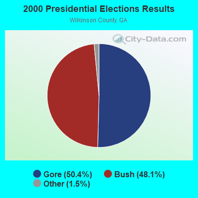
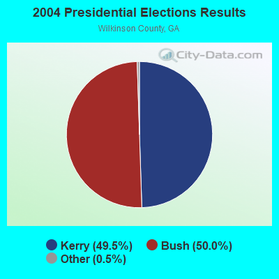
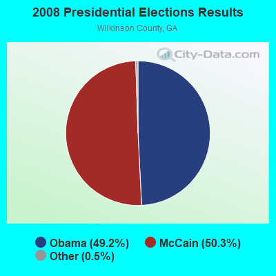


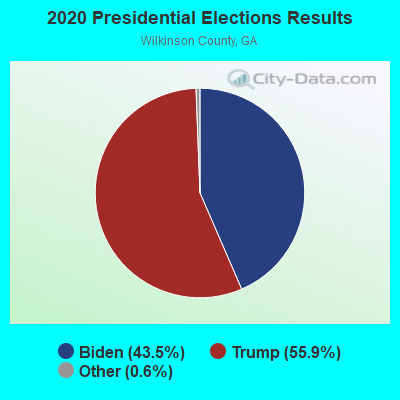
Graphs represent county-level data. Detailed 2008 Election Results
Religion statistics for McIntyre, GA (based on Wilkinson County data)

| Religion | Adherents | Congregations |
|---|---|---|
| Evangelical Protestant | 2,865 | 19 |
| Black Protestant | 1,170 | 7 |
| Mainline Protestant | 508 | 6 |
| Other | 11 | - |
| Catholic | - | - |
| None | 5,009 | - |
Food Environment Statistics:
| Wilkinson County: | 1.99 / 10,000 pop. |
| State: | 1.91 / 10,000 pop. |
| Wilkinson County: | 0.99 / 10,000 pop. |
| Georgia: | 0.86 / 10,000 pop. |
| Wilkinson County: | 7.95 / 10,000 pop. |
| State: | 5.12 / 10,000 pop. |
| Wilkinson County: | 3.98 / 10,000 pop. |
| Georgia: | 7.41 / 10,000 pop. |
| Wilkinson County: | 12.5% |
| Georgia: | 10.4% |
| This county: | 31.4% |
| Georgia: | 27.8% |
| This county: | 20.9% |
| State: | 14.6% |
Health and Nutrition:
| This city: | 46.5% |
| Georgia: | 48.9% |
| McIntyre: | 42.1% |
| State: | 46.5% |
| McIntyre: | 29.4 |
| Georgia: | 28.9 |
| This city: | 20.2% |
| Georgia: | 20.4% |
| This city: | 13.8% |
| Georgia: | 10.8% |
| McIntyre: | 6.7 |
| Georgia: | 6.7 |
| Here: | 33.3% |
| Georgia: | 33.5% |
| This city: | 51.6% |
| State: | 56.2% |
| This city: | 79.9% |
| State: | 80.8% |
More about Health and Nutrition of McIntyre, GA Residents
| Local government employment and payroll (March 2022) | |||||
| Function | Full-time employees | Monthly full-time payroll | Average yearly full-time wage | Part-time employees | Monthly part-time payroll |
|---|---|---|---|---|---|
| Other Government Administration | 8 | $10,000 | $15,000 | 1 | $790 |
| Police Protection - Officers | 5 | $17,660 | $42,384 | 0 | $0 |
| Streets and Highways | 2 | $7,067 | $42,402 | 0 | $0 |
| Water Supply | 1 | $4,953 | $59,436 | 0 | $0 |
| Totals for Government | 16 | $39,681 | $29,761 | 1 | $790 |
McIntyre government finances - Expenditure in 2017 (per resident):
- Construction - Central Staff Services: $14,000 ($24.96)
- Current Operations - Police Protection: $395,000 ($704.10)
Regular Highways: $288,000 ($513.37)
Central Staff Services: $230,000 ($409.98)
Parks and Recreation: $49,000 ($87.34)
Solid Waste Management: $22,000 ($39.22)
Local Fire Protection: $20,000 ($35.65)
Libraries: $15,000 ($26.74)
Financial Administration: $10,000 ($17.83)
Judicial and Legal Services: $8,000 ($14.26)
- Intergovernmental to Local - Other - Libraries: $15,000 ($26.74)
- Other Capital Outlay - Police Protection: $83,000 ($147.95)
Regular Highways: $7,000 ($12.48)
Parks and Recreation: $7,000 ($12.48)
Local Fire Protection: $5,000 ($8.91)
McIntyre government finances - Revenue in 2017 (per resident):
- Charges - Sewerage: $43,000 ($76.65)
Solid Waste Management: $22,000 ($39.22)
- Local Intergovernmental - Other: $46,000 ($82.00)
General Local Government Support: $33,000 ($58.82)
- Miscellaneous - Fines and Forfeits: $83,000 ($147.95)
Sale of Property: $6,000 ($10.70)
Interest Earnings: $5,000 ($8.91)
General Revenue - Other: $4,000 ($7.13)
Donations From Private Sources: $1,000 ($1.78)
- Revenue - Water Utilities: $64,000 ($114.08)
- State Intergovernmental - Other: $23,000 ($41.00)
- Tax - Public Utilities Sales: $691,000 ($1231.73)
Property: $137,000 ($244.21)
Insurance Premiums Sales: $41,000 ($73.08)
Other: $40,000 ($71.30)
Alcoholic Beverage Sales: $16,000 ($28.52)
Occupation and Business License - Other: $7,000 ($12.48)
McIntyre government finances - Cash and Securities in 2017 (per resident):
- Other Funds - Cash and Securities: $1,178,000 ($2099.82)
Businesses in McIntyre, GA
- Subway: 1
Strongest AM radio stations in McIntyre:
- WMAC (940 AM; 50 kW; MACON, GA; Owner: CUMULUS LICENSING CORP.)
- WXJO (1120 AM; daytime; 10 kW; GORDON, GA; Owner: ROBERTS COMMUNICATIONS, INC.)
- WNNG (1350 AM; 15 kW; WARNER ROBINS, GA; Owner: CHASE BROADCASTING, INC.)
- WGST (640 AM; 50 kW; ATLANTA, GA; Owner: CITICASTERS LICENSES, L.P.)
- WSB (750 AM; 50 kW; ATLANTA, GA; Owner: CXR HOLDINGS, INC.)
- WCNN (680 AM; 50 kW; NORTH ATLANTA, GA; Owner: DICKEY BROADCASTING COMPANY)
- WLCG (1280 AM; 5 kW; MACON, GA)
- WGUN (1010 AM; 50 kW; ATLANTA, GA; Owner: WGUN, INC.)
- WMLT (1330 AM; 5 kW; DUBLIN, GA; Owner: STATE BROADCASTING CORPORATION)
- WBML (900 AM; 2 kW; MACON, GA; Owner: WBML, INC.)
- WAOK (1380 AM; 50 kW; ATLANTA, GA; Owner: INFINITY BROADCASTING OPERATIONS, INC.)
- WMLB (1160 AM; 50 kW; EAST POINT, GA; Owner: ATLANTA AREA BROADCASTING, INC.)
- WQXI (790 AM; 28 kW; ATLANTA, GA; Owner: JEFFERSON-PILOT COMMUNICATIONS COMPANY OF GEORGIA)
Strongest FM radio stations in McIntyre:
- WVKX (103.7 FM; IRWINTON, GA; Owner: WILKINSON BROADCASTING, INC.)
- WGUR (88.9 FM; MILLEDGEVILLE, GA; Owner: GEORGIA COLLEGE & STATE UNIVERSITY)
- WFXM (107.1 FM; GORDON, GA; Owner: ROBERTS COMMUNICATIONS, INC.)
- WPEZ (93.7 FM; JEFFERSONVILLE, GA; Owner: CUMULUS LICENSING CORP.)
- WDCO-FM (89.7 FM; COCHRAN, GA; Owner: GEORGIA PUBLIC TELECOMMUNICATIONS COMMISSION)
- WPWB (90.5 FM; BYRON, GA; Owner: AUGUSTA RADIO FELLOWSHIP INST., INC.)
- WDEN-FM (99.1 FM; MACON, GA; Owner: CUMULUS LICENSING CORP.)
- WAYS (105.5 FM; MACON, GA; Owner: CUMULUS LICENSING CORP.)
- WLRR (100.7 FM; MILLEDGEVILLE, GA; Owner: PRESTON W. SMALL)
- WBKG (88.9 FM; MACON, GA; Owner: AMERICAN FAMILY ASSOCIATION)
- WQZY (95.9 FM; DUBLIN, GA; Owner: STATE BROADCASTING CORPORATION)
- WKZR (102.3 FM; MILLEDGEVILLE, GA; Owner: WMVG, INC.)
- WJFL (101.9 FM; TENNILLE, GA; Owner: FALL LINE MEDIA, INC.)
- WMCG (104.9 FM; MILAN, GA; Owner: TEL-DODGE BROADCASTING CO.)
- W201BN (88.1 FM; MILLEDGEVILLE, GA; Owner: CALVARY CHAPEL OF TWIN FALLS, INC.)
- WKKZ (92.7 FM; DUBLIN, GA; Owner: KIRBY BROADCASTING COMPANY)
- WMKS (92.3 FM; MACON, GA; Owner: CUMULUS LICENSING CORP.)
TV broadcast stations around McIntyre:
- WDCO-TV (Channel 29; COCHRAN, GA; Owner: GEORGIA PUBLIC TELECOMMUNICATIONS COMMISSION)
- WPGA-TV (Channel 58; PERRY, GA; Owner: RADIO PERRY, INC.)
- WMGT-TV (Channel 41; MACON, GA; Owner: MORRIS NETWORK, INC.)
- WMAZ-TV (Channel 13; MACON, GA; Owner: GANNETT GEORGIA, L.P.)
- WGXA (Channel 24; MACON, GA; Owner: PIEDMONT TELEVISION OF MACON LICENSE LLC)
- WGNM (Channel 64; MACON, GA; Owner: GOOD NEWS TELEVISION)
- WDMA-LP (Channel 32; MACON, GA; Owner: WORD OF GOD FELLOWSHIP, INC.)
- McIntyre, Georgia
- Fatal accident count12
- Vehicles involved in fatal accidents17
- Fatal accidents involving drunk persons:3
- Fatalities15
- Persons involved in fatal accidents25
- Pedestrians involved in fatal accidents0
- Georgia average
- Fatal accident count14538
- Vehicles involved in fatal accidents22649
- Fatal accidents involving drunk persons3665
- Fatalities16095
- Persons involved in fatal accidents36179
- Pedestrians involved in fatal accidents2172
- National Bridge Inventory (NBI) Statistics
- 18Number of bridges
- 367ft / 112mTotal length
- $21,593,000Total costs
- 32,000Total average daily traffic
- 2,348Total average daily truck traffic
- New bridges - historical statistics
- 71960-1969
- 21970-1979
- 11990-1999
- 62000-2009
FCC Registered Cell Phone Towers:
1 (See the full list of FCC Registered Cell Phone Towers in McIntyre)FCC Registered Antenna Towers:
27 (See the full list of FCC Registered Antenna Towers)FCC Registered Broadcast Land Mobile Towers:
3- 6 Km Nw On Hwy 57 (Lat: 32.829444 Lon: -83.239528), Type: Gtower, Structure height: 30.5 m, Overall height: 33.5 m, Call Sign: KIB629,
Assigned Frequencies: 159.285 MHz, 159.360 MHz, 159.390 MHz, 158.925 MHz, 154.280 MHz, 151.145 MHz, 159.277 MHz, 159.270 MHz, 159.255 MHz, 151.100 MHz, 151.115 MHz, Grant Date: 05/16/2014, Expiration Date: 08/04/2024, Certifier: Wray Hall, Registrant: Gta Gfc Wilkinson Unit, 5645 Riggins Mill Road, Dry Branch, GA 31020, Phone: (478) 751-3494, Email:
- On Us 411 2.5 Mi N (Lat: 32.885972 Lon: -83.191000), Call Sign: KVM816,
Assigned Frequencies: 451.050 MHz, 451.050 MHz, 451.475 MHz, 451.475 MHz, Grant Date: 04/09/2004, Expiration Date: 06/26/2014, Cancellation Date: 06/09/2008, Registrant: Mcdermott Will & Emery LLP, 600 Thirteenth Street, N.W., Washington, DC 20005-3096, Phone: (202) 756-8283, Fax: (202) 756-8087, Email:
- Lat: 32.853667 Lon: -83.153306, Call Sign: WQTS241,
Assigned Frequencies: 451.925 MHz, 451.975 MHz, 452.025 MHz, Grant Date: 04/01/2014, Expiration Date: 04/01/2024, Certifier: Clay Garnto, Registrant: Savannah Communications, Savannah, GA 31418, Phone: (912) 964-1479, Fax: (912) 966-5724, Email:
FCC Registered Microwave Towers:
2- MCINTYRE, 2.5 Mi Nw On Us Hwy 441 (Lat: 32.887917 Lon: -83.189306), Overall height: 81.7 m, Call Sign: WSX24,
Assigned Frequencies: 2192.80 MHz, Grant Date: 01/08/2003, Expiration Date: 02/09/2013, Cancellation Date: 06/09/2008, Registrant: Mcdermott Will & Emery LLP, 600 Thirteenth Street, N.W., Washington, DC 20005-3096, Phone: (202) 756-8283, Fax: (202) 756-8087, Email:
- MOUNT CARMEL, Rawland Near 508 Mount Carmel - 2503812 (Lat: 32.888750 Lon: -83.193556), Type: Ltower, Structure height: 74.6 m, Overall height: 76.2 m, Call Sign: WRKR462,
Assigned Frequencies: 11305.0 MHz, 11345.0 MHz, 11305.0 MHz, 11345.0 MHz, 11305.0 MHz, 11345.0 MHz, 11305.0 MHz, 11345.0 MHz, 11305.0 MHz, 11345.0 MHz, Grant Date: 02/02/2021, Expiration Date: 02/02/2031, Certifier: Christophe Le Scanve, Registrant: Cellco Partnership, 5055 North Point Pkwy, Np2ne Network Engineering, Alpharetta, GA 30022, Phone: (770) 797-1070, Email:
FCC Registered Amateur Radio Licenses:
4- Call Sign: K1FOX, Previous Call Sign: KF4FPF, Licensee ID: L01346312, Grant Date: 11/06/2017, Expiration Date: 01/07/2028, Certifier: Sarah M Handwerker, Registrant: Sarah M Handwerker, 22777 Hwy 441, Mcintyre, GA 31054
- Call Sign: KW4M, Licensee ID: L00947439, Grant Date: 12/02/2014, Expiration Date: 02/28/2025, Registrant: David R Fentem, 2021 Claymont Road, Mcintyre, GA 31054
- Call Sign: N4IBT, Licensee ID: L00510981, Grant Date: 10/10/2007, Expiration Date: 10/10/2017, Cancellation Date: 10/11/2019, Registrant: Bonnie J Boone, 41 Mt Carmel Rd, Mcintyre, GA 31054
- Call Sign: KO4MSW, Licensee ID: L02420615, Grant Date: 02/17/2021, Expiration Date: 02/17/2031, Certifier: Kathleen W Tompkins, Registrant: Kathleen W Tompkins, 134 Dedrick Rd, Mcintyre, GA 31054
FAA Registered Aircraft:
1- Aircraft: BEECH 58 (Category: Land, Engines: 2, Seats: 6, Weight: Up to 12,499 Pounds, Speed: 165 mph), Engine: CONT MOTOR IO 520 SERIES (285 HP) (Reciprocating)
N-Number: 111AW, N111AW, N-111AW, Serial Number: TH-841, Year manufactured: 1977, Airworthiness Date: 06/08/1977, Certificate Issue Date: 04/17/2017
Registrant (LLC): C&a Aviation LLC, 9474 Hwy 57, Mcintyre, GA 31054
2006 - 2018 National Fire Incident Reporting System (NFIRS) incidents
- Fire incident types reported to NFIRS in McIntyre, GA
- 5348.2%Outside Fires
- 4641.8%Structure Fires
- 98.2%Mobile Property/Vehicle Fires
- 21.8%Other
 Based on the data from the years 2006 - 2018 the average number of fires per year is 8. The highest number of reported fires - 38 took place in 2018, and the least - 0 in 2007. The data has an increasing trend.
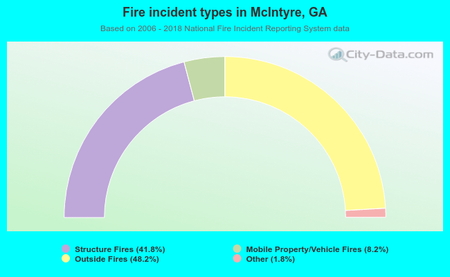 When looking into fire subcategories, the most incidents belonged to: Outside Fires (48.2%), and Structure Fires (41.8%).
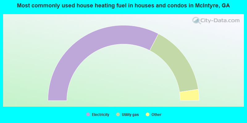
- 65.5%Electricity
- 30.0%Utility gas
- 2.5%Bottled, tank, or LP gas
- 2.0%Wood
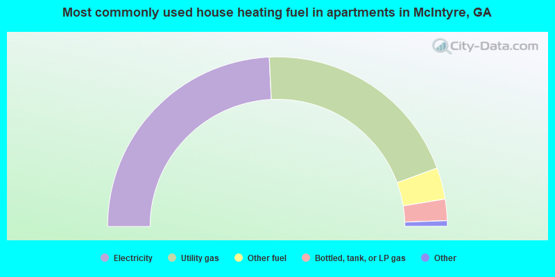
- 49.0%Electricity
- 40.8%Utility gas
- 6.1%Other fuel
- 4.1%Bottled, tank, or LP gas
McIntyre compared to Georgia state average:
- Median house value significantly below state average.
- Black race population percentage above state average.
- Median age below state average.
- Foreign-born population percentage below state average.
- Length of stay since moving in significantly above state average.
- House age above state average.