Bridge Statistics for McKean, Pennsylvania (PA)
Condition, Traffic, Stress, Structural Evaluation, Project Costs
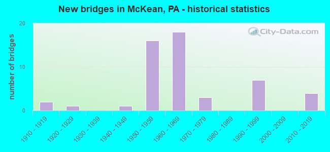
- New bridges - historical statistics
- 21910-1919
- 11920-1929
- 11940-1949
- 161950-1959
- 181960-1969
- 31970-1979
- 71990-1999
- 42010-2019
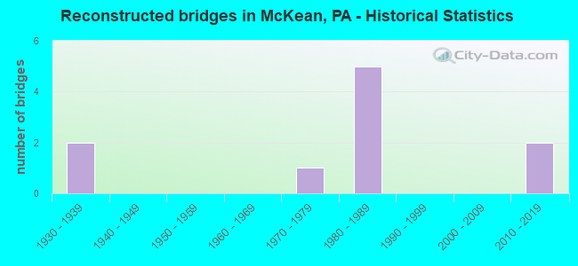
- Reconstructed bridges - Historical Statistics
- 21930-1939
- 01940-1949
- 01950-1959
- 01960-1969
- 11970-1979
- 51980-1989
- 01990-1999
- 02000-2009
- 22010-2019
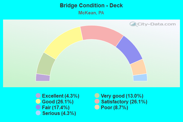
- Bridge Condition - Deck
- 4.3%Excellent
- 13.0%Very good
- 26.1%Good
- 26.1%Satisfactory
- 17.4%Fair
- 8.7%Poor
- 4.3%Serious
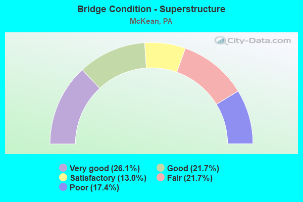
- Bridge Condition - Superstructure
- 26.1%Very good
- 21.7%Good
- 13.0%Satisfactory
- 21.7%Fair
- 17.4%Poor
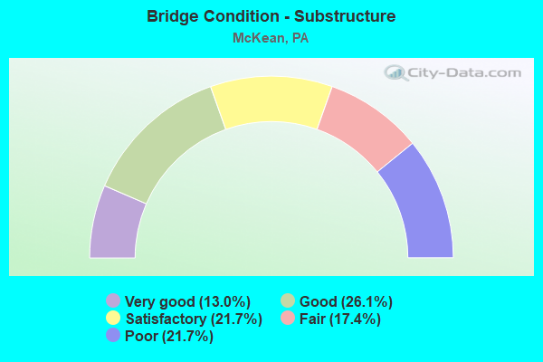
- Bridge Condition - Substructure
- 13.0%Very good
- 26.1%Good
- 21.7%Satisfactory
- 17.4%Fair
- 21.7%Poor
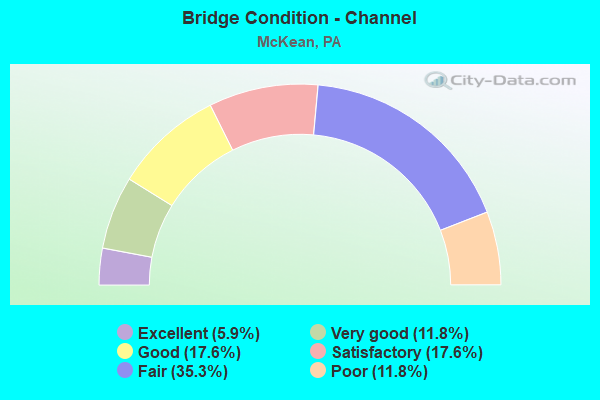
- Bridge Condition - Channel
- 5.9%Excellent
- 11.8%Very good
- 17.6%Good
- 17.6%Satisfactory
- 35.3%Fair
- 11.8%Poor
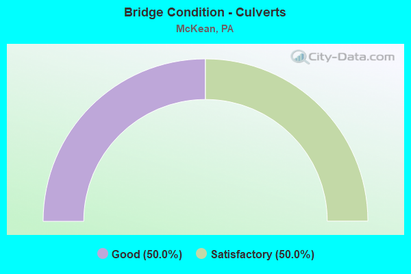
- Bridge Condition - Culverts
- 50.0%Good
- 50.0%Satisfactory
Find on map >> Show street view
Structure Number: 15953, Location: FRANKLIN TOWNSHIP (Lat: 41.958958, Lng: -80.173419), Route carried "on" structure: Interstate 79, Year Built: 1969, Status: Open, Structure Length: 2.77m (9.09ft), Average Daily Traffic: 12,450 (year 2021), Truck Traffic: 10%, Average Future Daily Traffic: 4,907 (year 2032), Design Load: HS 20+Mod, Features Intersected: OVER T-481,STANCLIFF RD
Minimum Vertical Clearance: 30+ m (98+ ft), Kilometerpoint: 12.043, Lanes on structure: 2, Lanes under structure: 2, Base Highway Network: Yes, Owner: State Highway Agency, Approaching Roadway Width: 11.6m (38.1ft), Skew: 10 degrees, Material/Design: Concrete continuous, Design/Construction: Slab, Number Of Spans In Main Unit: 3, Length of Maximum Span: 10.7m (35.1ft), Curb or Sidewalk Widths: Left: 0.2m (0.7ft), Right: 0.2m (0.7ft), Curb-To-Curb Width: 11.9m (39.0ft), Out-to-Out Width: 13.0m (42.7ft)
Condition: Deck: Good, Superstructure: Good, Substructure: Good, Operating Rating: 54.4 metric tons, Method Used To Determine Operating Rating: Load Factor (LF), Inventory Rating: 32.7 metric tons, Method Used To Determine Inventory Rating: Load Factor (LF), Structural Evaluation: Better than present minimum criteria, Deck Geometry: Equal to present minimum criteria, Underclear: Meets minimum limits, Approach Roadway Alignment: Equal to present desirable criteria, Length Of Structure Improvement: 3.50m (11.48ft), Designated Inspection Frequency: Every 24 months, Inspection Date: July 2020, Wearing Surface/Protective System: Wearing Surface: Latex Concrete
Find on map >> Show street view
Structure Number: 1596, Location: MCKEAN TOWNSHIP (Lat: 41.996764, Lng: -80.166889), Route carried "on" structure: Interstate 79, Year Built: 1969, Year Reconstructed: 1992, Status: Open, Structure Length: 8.02m (26.31ft), Average Daily Traffic: 6,968 (year 2020), Truck Traffic: 17%, Average Future Daily Traffic: 4,907 (year 2032), Design Load: HS 20, Features Intersected: OVER SR 3020 & ELK CK.
Minimum Vertical Clearance: 30+ m (98+ ft), Kilometerpoint: 16.111, Lanes on structure: 2, Lanes under structure: 2, Base Highway Network: Yes, Owner: State Highway Agency, Approaching Roadway Width: 11.6m (38.1ft), Skew: 13 degrees, Material/Design: Prestressed concrete, Design/Construction: Box Beam or Girders - Single/Spread, Number Of Spans In Main Unit: 4, Length of Maximum Span: 23.8m (78.1ft), Curb or Sidewalk Widths: Left: 0.2m (0.7ft), Right: 0.2m (0.7ft), Curb-To-Curb Width: 9.8m (32.2ft), Out-to-Out Width: 10.8m (35.4ft)
Condition: Deck: Satisfactory, Superstructure: Fair, Substructure: Satisfactory, Channel: Fair, Operating Rating: 98.9 metric tons, Method Used To Determine Operating Rating: Load Factor (LF), Inventory Rating: 39.0 metric tons, Method Used To Determine Inventory Rating: Load Factor (LF), Structural Evaluation: Somewhat better than minimum adequacy, Deck Geometry: Meets minimum limits, Underclear: Equal to present minimum criteria, Waterway Adequacy: Superior to present desirable criteria, Approach Roadway Alignment: Equal to present desirable criteria, Length Of Structure Improvement: 8.00m (26.25ft), Designated Inspection Frequency: Every 24 months, Inspection Date: April 2021, Bridge Improvement Cost: $10,000, Roadway Improvement Cost: $28,000, Total Project Cost: $129,000, Deck Structure Type: Concrete Cast-file-Place, Wearing Surface/Protective System: Wearing Surface: Monolithic Concrete, Deck Protection: Epoxy Coated Reinforcing
Find on map >> Show street view
Structure Number: 15966, Location: MCKEAN TOWNSHIP (Lat: 42.032097, Lng: -80.122203), Route carried "on" structure: Interstate 79, Year Built: 1994, Status: Open, Structure Length: 7.44m (24.41ft), Average Daily Traffic: 11,597 (year 2021), Truck Traffic: 7%, Average Future Daily Traffic: 15,819 (year 2032), Design Load: HS 25 or greater, Features Intersected: OVER SR 90,EB/WB
Minimum Vertical Clearance: 30+ m (98+ ft), Kilometerpoint: 22.312, Lanes on structure: 3, Lanes under structure: 12, Base Highway Network: Yes, Owner: State Highway Agency, Approaching Roadway Width: 15.2m (49.9ft), Skew: 13 degrees, Material/Design: Prestressed concrete continuous, Design/Construction: Box Beam or Girders - Multiple, Number Of Spans In Main Unit: 2, Length of Maximum Span: 37.5m (123.0ft), Curb or Sidewalk Widths: Left: 0.2m (0.7ft), Right: 0.2m (0.7ft), Curb-To-Curb Width: 15.2m (49.9ft), Out-to-Out Width: 16.2m (53.1ft)
Condition: Deck: Good, Superstructure: Good, Substructure: Good, Operating Rating: 89.8 metric tons, Method Used To Determine Operating Rating: Load Factor (LF), Inventory Rating: 50.8 metric tons, Method Used To Determine Inventory Rating: Load Factor (LF), Structural Evaluation: Better than present minimum criteria, Deck Geometry: Meets minimum limits, Underclear: Equal to present minimum criteria, Approach Roadway Alignment: Equal to present desirable criteria, Length Of Structure Improvement: 8.40m (27.56ft), Designated Inspection Frequency: Every 24 months, Inspection Date: July 2020, Deck Structure Type: Concrete Cast-file-Place, Wearing Surface/Protective System: Wearing Surface: Bituminous, Membrane: Preformed Fabric, Deck Protection: Epoxy Coated Reinforcing
Find on map >> Show street view
Structure Number: 15969, Location: MCKEAN TOWNSHIP (Lat: 42.031803, Lng: -80.122731), Route carried "on" structure: Interstate 79, Year Built: 1994, Status: Open, Structure Length: 7.53m (24.70ft), Average Daily Traffic: 10,867 (year 2021), Truck Traffic: 8%, Average Future Daily Traffic: 15,467 (year 2032), Design Load: HS 25 or greater, Features Intersected: OVER SR 90,EB/WB
Minimum Vertical Clearance: 30+ m (98+ ft), Kilometerpoint: 22.296, Lanes on structure: 3, Lanes under structure: 12, Base Highway Network: Yes, Owner: State Highway Agency, Approaching Roadway Width: 15.2m (49.9ft), Skew: 13 degrees, Material/Design: Prestressed concrete continuous, Design/Construction: Box Beam or Girders - Multiple, Number Of Spans In Main Unit: 2, Length of Maximum Span: 37.5m (123.0ft), Curb or Sidewalk Widths: Left: 0.2m (0.7ft), Right: 0.2m (0.7ft), Curb-To-Curb Width: 15.3m (50.2ft), Out-to-Out Width: 16.3m (53.5ft)
Condition: Deck: Satisfactory, Superstructure: Good, Substructure: Good, Operating Rating: 89.8 metric tons, Method Used To Determine Operating Rating: Load Factor (LF), Inventory Rating: 50.8 metric tons, Method Used To Determine Inventory Rating: Load Factor (LF), Structural Evaluation: Better than present minimum criteria, Deck Geometry: Meets minimum limits, Underclear: Equal to present minimum criteria, Approach Roadway Alignment: Equal to present desirable criteria, Length Of Structure Improvement: 8.50m (27.89ft), Designated Inspection Frequency: Every 24 months, Inspection Date: July 2020, Bridge Improvement Cost: $256,000, Roadway Improvement Cost: $754,000, Total Project Cost: $3,456,000, Deck Structure Type: Concrete Cast-file-Place, Wearing Surface/Protective System: Wearing Surface: Bituminous, Membrane: Preformed Fabric, Deck Protection: Epoxy Coated Reinforcing
Find on map >> Show street view
Structure Number: 16042, Location: MCKEAN TOWNSHIP (Lat: 42.020747, Lng: -80.171331), Route carried "on" structure: State highway , Year Built: 1959, Status: Open, Structure Length: 6.31m (20.70ft), Average Daily Traffic: 977 (year 2020), Truck Traffic: 4%, Average Future Daily Traffic: 859 (year 2032), Design Load: HS 20, Features Intersected: OVER SR 90,EB/WB, Facility Carried by Structure: T-442,MILLFAIR
Minimum Vertical Clearance: 30+ m (98+ ft), Kilometerpoint: 0.000, Lanes on structure: 2, Lanes under structure: 8, Owner: State Highway Agency, Approaching Roadway Width: 6.4m (21.0ft), Skew: 1 degrees, Material/Design: Steel continuous, Design/Construction: Stringer/Multi-beam, Number Of Spans In Main Unit: 2, Number Of Approach Spans: 2, Length of Maximum Span: 20.4m (66.9ft), Curb or Sidewalk Widths: Left: 0.5m (1.6ft), Right: 0.5m (1.6ft), Curb-To-Curb Width: 8.5m (27.9ft), Out-to-Out Width: 10.2m (33.5ft)
Condition: Deck: Satisfactory, Superstructure: Fair, Substructure: Satisfactory, Operating Rating: 57.2 metric tons, Method Used To Determine Operating Rating: Load Factor (LF), Inventory Rating: 36.3 metric tons, Method Used To Determine Inventory Rating: Load Factor (LF), Structural Evaluation: Somewhat better than minimum adequacy, Deck Geometry: Somewhat better than minimum adequacy, Underclear: Somewhat better than minimum adequacy, Approach Roadway Alignment: Better than present minimum criteria, Length Of Structure Improvement: 6.20m (20.34ft), Designated Inspection Frequency: Every 24 months, Inspection Date: May 2020, Bridge Improvement Cost: $15,000, Roadway Improvement Cost: $44,000, Total Project Cost: $203,000, Deck Structure Type: Concrete Cast-file-Place, Wearing Surface/Protective System: Wearing Surface: Bituminous, Membrane: Preformed Fabric
Find on map >> Show street view
Structure Number: 16044, Location: MCKEAN TOWNSHIP (Lat: 42.027636, Lng: -80.131411), Route carried "on" structure: State highway , Year Built: 1959, Status: Open, Structure Length: 6.10m (20.01ft), Average Daily Traffic: 665 (year 2020), Truck Traffic: 4%, Average Future Daily Traffic: 967 (year 2032), Design Load: HS 20, Features Intersected: OVER SR 90,EB/WB, Facility Carried by Structure: T-490,BARGAIN RD
Minimum Vertical Clearance: 30+ m (98+ ft), Kilometerpoint: 0.000, Lanes on structure: 2, Lanes under structure: 8, Owner: State Highway Agency, Approaching Roadway Width: 5.8m (19.0ft), Material/Design: Prestressed concrete, Design/Construction: Box Beam or Girders - Multiple, Number Of Spans In Main Unit: 4, Length of Maximum Span: 19.5m (64.0ft), Curb or Sidewalk Widths: Left: 0.5m (1.6ft), Right: 0.5m (1.6ft), Curb-To-Curb Width: 8.5m (27.9ft), Out-to-Out Width: 10.2m (33.5ft)
Condition: Deck: Satisfactory, Superstructure: Satisfactory, Substructure: Good, Operating Rating: 58.1 metric tons, Method Used To Determine Operating Rating: Load Factor (LF), Inventory Rating: 34.5 metric tons, Method Used To Determine Inventory Rating: Load Factor (LF), Structural Evaluation: Equal to present minimum criteria, Deck Geometry: Somewhat better than minimum adequacy, Underclear: Equal to present minimum criteria, Approach Roadway Alignment: Better than present minimum criteria, Length Of Structure Improvement: 7.10m (23.29ft), Designated Inspection Frequency: Every 24 months, Inspection Date: May 2020, Deck Structure Type: Concrete Cast-file-Place, Wearing Surface/Protective System: Wearing Surface: Bituminous, Membrane: Other
Find on map >> Show street view
Structure Number: 16146, Location: MCKEAN TOWNSHIP (Lat: 41.959853, Lng: -80.138333), Route carried "on" structure: State highway 99, Year Built: 1968, Status: Open, Structure Length: 3.41m (11.19ft), Average Daily Traffic: 6,273 (year 2022), Truck Traffic: 4%, Average Future Daily Traffic: 7,729 (year 2032), Design Load: HS 20, Features Intersected: OVER T-481,STANCLIFF RD
Minimum Vertical Clearance: 30+ m (98+ ft), Kilometerpoint: 12.801, Lanes on structure: 2, Lanes under structure: 2, Owner: State Highway Agency, Approaching Roadway Width: 7.0m (23.0ft), Skew: 1 degrees, Material/Design: Prestressed concrete, Design/Construction: Box Beam or Girders - Single/Spread, Number Of Spans In Main Unit: 3, Length of Maximum Span: 12.5m (41.0ft), Curb or Sidewalk Widths: Left: 0.2m (0.7ft), Right: 0.2m (0.7ft), Curb-To-Curb Width: 12.2m (40.0ft), Out-to-Out Width: 13.4m (44.0ft)
Condition: Deck: Fair, Superstructure: Satisfactory, Substructure: Satisfactory, Operating Rating: 76.2 metric tons, Method Used To Determine Operating Rating: Load Factor (LF), Inventory Rating: 36.3 metric tons, Method Used To Determine Inventory Rating: Load Factor (LF), Structural Evaluation: Equal to present minimum criteria, Deck Geometry: Somewhat better than minimum adequacy, Underclear: Meets minimum limits, Approach Roadway Alignment: Equal to present desirable criteria, Length Of Structure Improvement: 3.40m (11.15ft), Designated Inspection Frequency: Every 24 months, Inspection Date: May 2020, Bridge Improvement Cost: $19,000, Roadway Improvement Cost: $57,000, Total Project Cost: $260,000, Deck Structure Type: Concrete Cast-file-Place, Wearing Surface/Protective System: Wearing Surface: Bituminous, Membrane: Other
Find on map >> Show street view
Structure Number: 16147, Location: MCKEAN TOWNSHIP (Lat: 41.977675, Lng: -80.140917), Route carried "on" structure: State highway 99, Year Built: 1968, Status: Open, Structure Length: 0.85m (2.79ft), Average Daily Traffic: 6,273 (year 2022), Truck Traffic: 4%, Average Future Daily Traffic: 7,729 (year 2032), Design Load: HS 20, Features Intersected: OVER ELK CREEK TRIB S.BR
Minimum Vertical Clearance: 30+ m (98+ ft), Kilometerpoint: 14.318, Lanes on structure: 2, Owner: State Highway Agency, Approaching Roadway Width: 7.3m (24.0ft), Skew: 4 degrees, Material/Design: Concrete, Design/Construction: Culvert, Number Of Spans In Main Unit: 1, Length of Maximum Span: 8.5m (27.9ft)
Condition: Channel: Satisfactory, Culverts: Satisfactory, Operating Rating: 49.0 metric tons, Method Used To Determine Operating Rating: Field evaluation and documented engineering judgment, Inventory Rating: 32.7 metric tons, Method Used To Determine Inventory Rating: Field evaluation and documented engineering judgment, Structural Evaluation: Equal to present minimum criteria, Waterway Adequacy: Superior to present desirable criteria, Approach Roadway Alignment: Equal to present desirable criteria, Length Of Structure Improvement: 1.20m (3.94ft), Designated Inspection Frequency: Every 48 months, Inspection Date: May 2020
Find on map >> Show street view
Structure Number: 16148, Location: MCKEAN BOROUGH (Lat: 42.001078, Lng: -80.142317), Route carried "on" structure: State highway 99, Year Built: 1952, Year Reconstructed: 1987, Status: Open, Structure Length: 1.83m (6.00ft), Average Daily Traffic: 6,235 (year 2020), Truck Traffic: 5%, Average Future Daily Traffic: 6,939 (year 2032), Design Load: HS 20, Features Intersected: OVER ELK CREEK
Minimum Vertical Clearance: 30+ m (98+ ft), Kilometerpoint: 17.186, Lanes on structure: 2, Owner: State Highway Agency, Approaching Roadway Width: 9.1m (29.9ft), Skew: 1 degrees, Material/Design: Concrete, Design/Construction: Tee Beam, Number Of Spans In Main Unit: 2, Length of Maximum Span: 8.8m (28.9ft), Curb-To-Curb Width: 12.1m (39.7ft), Out-to-Out Width: 13.3m (43.6ft)
Condition: Deck: Satisfactory, Superstructure: Good, Substructure: Fair, Channel: Fair, Operating Rating: 80.7 metric tons, Method Used To Determine Operating Rating: Field evaluation and documented engineering judgment, Inventory Rating: 48.1 metric tons, Method Used To Determine Inventory Rating: Field evaluation and documented engineering judgment, Structural Evaluation: Somewhat better than minimum adequacy, Deck Geometry: Somewhat better than minimum adequacy, Waterway Adequacy: Equal to present minimum criteria, Approach Roadway Alignment: Equal to present desirable criteria, Length Of Structure Improvement: 1.80m (5.91ft), Designated Inspection Frequency: Every 24 months, Inspection Date: July 2020, Bridge Improvement Cost: $5,000, Roadway Improvement Cost: $25,000, Total Project Cost: $70,000, Wearing Surface/Protective System: Wearing Surface: Bituminous, Membrane: Preformed Fabric
Find on map >> Show street view
Structure Number: 16151, Location: SUMMIT TOWNSHIP (Lat: 42.036703, Lng: -80.112486), Route carried "on" structure: State highway 99, Year Built: 1959, Year Reconstructed: 1986, Status: Open, Structure Length: 8.26m (27.10ft), Average Daily Traffic: 4,889 (year 2020), Truck Traffic: 3%, Average Future Daily Traffic: 6,579 (year 2032), Design Load: HS 20, Features Intersected: OVER SR 90,EB/WB
Minimum Vertical Clearance: 30+ m (98+ ft), Kilometerpoint: 21.472, Lanes on structure: 2, Lanes under structure: 8, Owner: State Highway Agency, Approaching Roadway Width: 9.1m (29.9ft), Skew: 4 degrees, Material/Design: Prestressed concrete, Design/Construction: Box Beam or Girders - Multiple, Number Of Spans In Main Unit: 4, Length of Maximum Span: 26.8m (87.9ft), Curb or Sidewalk Widths: Left: 0.2m (0.7ft), Right: 0.2m (0.7ft), Curb-To-Curb Width: 9.1m (29.9ft), Out-to-Out Width: 10.8m (35.4ft)
Condition: Deck: Fair, Superstructure: Poor, Substructure: Poor, Operating Rating: 86.2 metric tons, Method Used To Determine Operating Rating: Load Factor (LF), Inventory Rating: 44.5 metric tons, Method Used To Determine Inventory Rating: Load Factor (LF), Structural Evaluation: Meets minimum limits, Deck Geometry: Meets minimum limits, Underclear: Better than present minimum criteria, Approach Roadway Alignment: Better than present minimum criteria, Length Of Structure Improvement: 9.30m (30.51ft), Designated Inspection Frequency: Every 24 months, Inspection Date: September 2020, Bridge Improvement Cost: $32,000, Roadway Improvement Cost: $93,000, Total Project Cost: $426,000, Deck Structure Type: Concrete Cast-file-Place, Wearing Surface/Protective System: Wearing Surface: Bituminous, Membrane: Preformed Fabric
Find on map >> Show street view
Structure Number: 16186, Location: MCKEAN TOWNSHIP (Lat: 42.018433, Lng: -80.188225), Route carried "on" structure: State highway 832, Year Built: 1959, Year Reconstructed: 1976, Status: Open, Structure Length: 8.11m (26.61ft), Average Daily Traffic: 6,405 (year 2020), Truck Traffic: 5%, Average Future Daily Traffic: 8,120 (year 2032), Design Load: HS 20, Features Intersected: OVER SR 90,EB/WB
Minimum Vertical Clearance: 30+ m (98+ ft), Kilometerpoint: 5.058, Lanes on structure: 2, Lanes under structure: 8, Base Highway Network: Yes, Owner: State Highway Agency, Approaching Roadway Width: 12.2m (40.0ft), Skew: 4 degrees, Material/Design: Steel continuous, Design/Construction: Stringer/Multi-beam, Number Of Spans In Main Unit: 2, Number Of Approach Spans: 2, Length of Maximum Span: 25.9m (85.0ft), Curb or Sidewalk Widths: Left: 0.2m (0.7ft), Right: 0.2m (0.7ft), Curb-To-Curb Width: 12.2m (40.0ft), Out-to-Out Width: 13.3m (43.6ft)
Condition: Deck: Fair, Superstructure: Fair, Substructure: Poor, Operating Rating: 59.0 metric tons, Method Used To Determine Operating Rating: Load Factor (LF), Inventory Rating: 35.4 metric tons, Method Used To Determine Inventory Rating: Load Factor (LF), Structural Evaluation: Meets minimum limits, Deck Geometry: Somewhat better than minimum adequacy, Underclear: Equal to present minimum criteria, Approach Roadway Alignment: Equal to present desirable criteria, Length Of Structure Improvement: 8.10m (26.57ft), Designated Inspection Frequency: Every 24 months, Other Special Inspection Frequency: Every 6 months, Inspection Date: July 2020, Other Special Inspection Date: July 2021, Bridge Improvement Cost: $24,000, Roadway Improvement Cost: $70,000, Total Project Cost: $321,000, Deck Structure Type: Concrete Cast-file-Place, Wearing Surface/Protective System: Wearing Surface: Latex Concrete
Find on map >> Show street view
Structure Number: 16341, Location: MCKEAN TOWNSHIP (Lat: 41.996831, Lng: -80.150025), Route carried "on" structure: State highway , Year Built: 1970, Year Reconstructed: 2017, Status: Open, Structure Length: 1.46m (4.79ft), Average Daily Traffic: 5,259 (year 2020), Truck Traffic: 6%, Average Future Daily Traffic: 5,285 (year 2032), Design Load: HL 93, Features Intersected: OVER LAMSON RUN, Facility Carried by Structure: SR 3020,WEST ROAD
Minimum Vertical Clearance: 30+ m (98+ ft), Kilometerpoint: 4.225, Lanes on structure: 2, Owner: State Highway Agency, Approaching Roadway Width: 9.4m (30.8ft), Skew: 2 degrees, Material/Design: Prestressed concrete, Design/Construction: Box Beam or Girders - Single/Spread, Number Of Spans In Main Unit: 1, Length of Maximum Span: 14.3m (46.9ft), Curb or Sidewalk Widths: Left: 0.2m (0.7ft), Right: 0.2m (0.7ft), Curb-To-Curb Width: 11.8m (38.7ft), Out-to-Out Width: 12.8m (42.0ft)
Condition: Deck: Very good, Superstructure: Very good, Substructure: Good, Channel: Satisfactory, Operating Rating: 42.8 metric tons, Method Used To Determine Operating Rating: Assigned ratings based on Load and Resistance Factor Design (LRFD) reported by rating factor (RF) using HL93 loadings, Inventory Rating: 33.0 metric tons, Method Used To Determine Inventory Rating: Assigned ratings based on Load and Resistance Factor Design (LRFD) reported by rating factor (RF) using HL93 loadings, Structural Evaluation: Better than present minimum criteria, Deck Geometry: Somewhat better than minimum adequacy, Waterway Adequacy: Equal to present minimum criteria, Approach Roadway Alignment: Equal to present desirable criteria, Length Of Structure Improvement: 1.50m (4.92ft), Designated Inspection Frequency: Every 24 months, Inspection Date: August 2021, Bridge Improvement Cost: $9,000, Roadway Improvement Cost: $25,000, Total Project Cost: $117,000, Deck Structure Type: Concrete Cast-file-Place, Wearing Surface/Protective System: Wearing Surface: Bituminous, Membrane: Preformed Fabric, Deck Protection: Epoxy Coated Reinforcing
Find on map >> Show street view
Structure Number: 16343, Location: MCKEAN TOWNSHIP (Lat: 41.980081, Lng: -80.204181), Route carried "on" structure: State highway , Year Built: 1973, Status: Open, Structure Length: 0.61m (2.00ft), Average Daily Traffic: 234 (year 2021), Truck Traffic: 4%, Average Future Daily Traffic: 229 (year 2032), Design Load: HS 20, Features Intersected: OVER PORTER RUN, Facility Carried by Structure: SR 3021,EUREKA RD
Minimum Vertical Clearance: 30+ m (98+ ft), Kilometerpoint: 4.237, Lanes on structure: 2, Owner: State Highway Agency, Approaching Roadway Width: 5.5m (18.0ft), Skew: 1 degrees, Material/Design: Concrete, Design/Construction: Culvert, Number Of Spans In Main Unit: 1, Length of Maximum Span: 6.1m (20.0ft)
Condition: Channel: Good, Culverts: Good, Operating Rating: 49.0 metric tons, Method Used To Determine Operating Rating: Allowable Stress (AS), Inventory Rating: 32.7 metric tons, Method Used To Determine Inventory Rating: Allowable Stress (AS), Structural Evaluation: Better than present minimum criteria, Waterway Adequacy: Superior to present desirable criteria, Approach Roadway Alignment: Equal to present desirable criteria, Length Of Structure Improvement: 1.20m (3.94ft), Designated Inspection Frequency: Every 48 months, Inspection Date: October 2019
Find on map >> Show street view
Structure Number: 16369, Location: MCKEAN TOWNSHIP (Lat: 42.016106, Lng: -80.142164), Route carried "on" structure: State highway , Year Built: 1969, Status: Open, Structure Length: 8.41m (27.59ft), Average Daily Traffic: 1,598 (year 2022), Truck Traffic: 6%, Average Future Daily Traffic: 2,838 (year 2032), Design Load: HS 20, Features Intersected: OVER SR 79,NB/SB, Facility Carried by Structure: SR 4011,GRUBB ROAD
Minimum Vertical Clearance: 30+ m (98+ ft), Kilometerpoint: 1.376, Lanes on structure: 2, Lanes under structure: 8, Owner: State Highway Agency, Approaching Roadway Width: 6.1m (20.0ft), Skew: 2 degrees, Material/Design: Prestressed concrete, Design/Construction: Box Beam or Girders - Single/Spread, Number Of Spans In Main Unit: 5, Length of Maximum Span: 19.8m (65.0ft), Curb-To-Curb Width: 8.5m (27.9ft), Out-to-Out Width: 10.2m (33.5ft)
Condition: Deck: Satisfactory, Superstructure: Satisfactory, Substructure: Satisfactory, Operating Rating: 53.5 metric tons, Method Used To Determine Operating Rating: Load Factor (LF), Inventory Rating: 32.7 metric tons, Method Used To Determine Inventory Rating: Load Factor (LF), Structural Evaluation: Equal to present minimum criteria, Deck Geometry: Somewhat better than minimum adequacy, Underclear: Better than present minimum criteria, Approach Roadway Alignment: Better than present minimum criteria, Length Of Structure Improvement: 8.40m (27.56ft), Designated Inspection Frequency: Every 24 months, Inspection Date: July 2020, Bridge Improvement Cost: $14,000, Roadway Improvement Cost: $40,000, Total Project Cost: $183,000, Deck Structure Type: Concrete Cast-file-Place, Wearing Surface/Protective System: Wearing Surface: Bituminous, Membrane: Preformed Fabric
Find on map >> Show street view
Structure Number: 1637, Location: MCKEAN TOWNSHIP (Lat: 42.024053, Lng: -80.142111), Route carried "on" structure: State highway , Year Built: 1959, Year Reconstructed: 2010, Status: Open, Structure Length: 6.25m (20.51ft), Average Daily Traffic: 1,598 (year 2022), Truck Traffic: 6%, Average Future Daily Traffic: 2,838 (year 2032), Design Load: HS 20+Mod, Features Intersected: OVER SR 90,EB/WB, Facility Carried by Structure: SR 4011,GRUBB ROAD
Minimum Vertical Clearance: 30+ m (98+ ft), Kilometerpoint: 2.272, Lanes on structure: 2, Lanes under structure: 8, Owner: State Highway Agency, Approaching Roadway Width: 6.1m (20.0ft), Skew: 1 degrees, Material/Design: Prestressed concrete, Design/Construction: Box Beam or Girders - Multiple, Number Of Spans In Main Unit: 4, Length of Maximum Span: 20.1m (65.9ft), Curb or Sidewalk Widths: Left: 0.5m (1.6ft), Right: 0.5m (1.6ft), Curb-To-Curb Width: 9.1m (29.9ft), Out-to-Out Width: 10.8m (35.4ft)
Condition: Deck: Good, Superstructure: Fair, Substructure: Fair, Operating Rating: 74.4 metric tons, Method Used To Determine Operating Rating: Load Factor (LF), Inventory Rating: 32.7 metric tons, Method Used To Determine Inventory Rating: Load Factor (LF), Structural Evaluation: Somewhat better than minimum adequacy, Deck Geometry: Somewhat better than minimum adequacy, Underclear: Superior to present desirable criteria, Approach Roadway Alignment: Better than present minimum criteria, Length Of Structure Improvement: 7.20m (23.62ft), Designated Inspection Frequency: Every 24 months, Inspection Date: July 2020, Bridge Improvement Cost: $56,000, Roadway Improvement Cost: $166,000, Total Project Cost: $761,000, Deck Structure Type: Concrete Cast-file-Place, Wearing Surface/Protective System: Wearing Surface: Monolithic Concrete
Find on map >> Show street view
Structure Number: 16452, Location: AT S. HILL RD INTERSECT (Lat: 41.980356, Lng: -80.143883), Route carried "on" structure: City street , Year Built: 1913, Year Reconstructed: 1941, Status: Posted for load, Structure Length: 0.76m (2.49ft), Average Daily Traffic: 695 (year 2013), Truck Traffic: 3%, Average Future Daily Traffic: 754 (year 2033), Design Load: H 15, Features Intersected: LAMSON RUN TRIBUTARY, Facility Carried by Structure: T-480, OLD RTE 99
Minimum Vertical Clearance: 30+ m (98+ ft), Kilometerpoint: 0.000, Lanes on structure: 2, Owner: Town or Township Highway Agency, Approaching Roadway Width: 6.1m (20.0ft), Skew: 1 degrees, Material/Design: Concrete continuous, Design/Construction: Stringer/Multi-beam, Number Of Spans In Main Unit: 1, Length of Maximum Span: 6.7m (22.0ft), Curb or Sidewalk Widths: Left: 0.2m (0.7ft), Right: 0.2m (0.7ft), Curb-To-Curb Width: 8.5m (27.9ft), Out-to-Out Width: 9.4m (30.8ft)
Condition: Deck: Poor, Superstructure: Poor, Substructure: Poor, Channel: Satisfactory, Operating Rating: 48.1 metric tons, Method Used To Determine Operating Rating: Load Factor (LF), Inventory Rating: 28.1 metric tons, Method Used To Determine Inventory Rating: Load Factor (LF), Structural Evaluation: Meets minimum limits, Deck Geometry: Somewhat better than minimum adequacy, Waterway Adequacy: Equal to present minimum criteria, Approach Roadway Alignment: Better than present minimum criteria, Bridge Posting: Required (Relationship of Operating Rating to Maximum Legal Load: 0.1 - 9.9% below), Length Of Structure Improvement: 0.70m (2.30ft), Designated Inspection Frequency: Every 24 months, Other Special Inspection Frequency: Every 12 months, Inspection Date: August 2021, Other Special Inspection Date: August 2021, Bridge Improvement Cost: $2,000, Roadway Improvement Cost: $7,000, Total Project Cost: $30,000, Deck Structure Type: Concrete Cast-file-Place, Wearing Surface/Protective System: Wearing Surface: Bituminous
Find on map >> Show street view
Structure Number: 16453, Location: 1700' N OF STANCLIFF RD (Lat: 41.964383, Lng: -80.141319), Route carried "on" structure: City street , Year Built: 1913, Year Reconstructed: 1941, Status: Posted for load, Structure Length: 1.01m (3.31ft), Average Daily Traffic: 610 (year 2013), Truck Traffic: 3%, Average Future Daily Traffic: 662 (year 2033), Design Load: HS 20, Features Intersected: LAMSON RUN, Facility Carried by Structure: T-480, OLD RTE 99
Minimum Vertical Clearance: 30+ m (98+ ft), Kilometerpoint: 0.000, Lanes on structure: 2, Owner: Town or Township Highway Agency, Approaching Roadway Width: 6.4m (21.0ft), Skew: 1 degrees, Material/Design: Concrete continuous, Design/Construction: Stringer/Multi-beam, Number Of Spans In Main Unit: 1, Length of Maximum Span: 8.5m (27.9ft), Curb or Sidewalk Widths: Left: 0.2m (0.7ft), Right: 0.2m (0.7ft), Curb-To-Curb Width: 8.3m (27.2ft), Out-to-Out Width: 9.1m (29.9ft)
Condition: Deck: Serious, Superstructure: Poor, Substructure: Poor, Channel: Fair, Operating Rating: 22.7 metric tons, Method Used To Determine Operating Rating: Load Factor (LF), Inventory Rating: 13.6 metric tons, Method Used To Determine Inventory Rating: Load Factor (LF), Structural Evaluation: Meets minimum limits, Deck Geometry: Somewhat better than minimum adequacy, Waterway Adequacy: Equal to present desirable criteria, Approach Roadway Alignment: Better than present minimum criteria, Bridge Posting: Required (Relationship of Operating Rating to Maximum Legal Load: 30.0 - 39.9% below), Length Of Structure Improvement: 0.90m (2.95ft), Designated Inspection Frequency: Every 24 months, Other Special Inspection Frequency: Every 12 months, Inspection Date: August 2021, Other Special Inspection Date: August 2021, Bridge Improvement Cost: $3,000, Roadway Improvement Cost: $8,000, Total Project Cost: $38,000, Deck Structure Type: Concrete Cast-file-Place, Wearing Surface/Protective System: Wearing Surface: Bituminous
Find on map >> Show street view
Structure Number: 16454, Location: 750' N OF STANCLIFF RD (Lat: 41.961825, Lng: -80.142097), Route carried "on" structure: City street , Year Built: 1941, Status: Open, Structure Length: 0.85m (2.79ft), Average Daily Traffic: 561 (year 2013), Truck Traffic: 4%, Average Future Daily Traffic: 609 (year 2033), Design Load: H 20, Features Intersected: LAMSON RUN, Facility Carried by Structure: T-480, OLD RTE 99
Minimum Vertical Clearance: 30+ m (98+ ft), Kilometerpoint: 0.000, Lanes on structure: 2, Owner: Town or Township Highway Agency, Approaching Roadway Width: 6.1m (20.0ft), Material/Design: Concrete, Design/Construction: Tee Beam, Number Of Spans In Main Unit: 1, Length of Maximum Span: 7.3m (24.0ft), Curb or Sidewalk Widths: Left: 0.2m (0.7ft), Right: 0.2m (0.7ft), Curb-To-Curb Width: 8.6m (28.2ft), Out-to-Out Width: 9.5m (31.2ft)
Condition: Deck: Fair, Superstructure: Fair, Substructure: Poor, Channel: Fair, Operating Rating: 76.2 metric tons, Method Used To Determine Operating Rating: Field evaluation and documented engineering judgment, Inventory Rating: 45.4 metric tons, Method Used To Determine Inventory Rating: Field evaluation and documented engineering judgment, Structural Evaluation: Meets minimum limits, Deck Geometry: Somewhat better than minimum adequacy, Waterway Adequacy: Better than present minimum criteria, Approach Roadway Alignment: Better than present minimum criteria, Length Of Structure Improvement: 1.40m (4.59ft), Designated Inspection Frequency: Every 24 months, Inspection Date: August 2021, Deck Structure Type: Concrete Cast-file-Place, Wearing Surface/Protective System: Wearing Surface: Bituminous
Find on map >> Show street view
Structure Number: 16458, Location: 450' E OF STEAMWOOD DR (Lat: 42.052214, Lng: -80.167006), Route carried "on" structure: City street , Year Built: 1929, Status: Posted for load, Structure Length: 2.04m (6.69ft), Average Daily Traffic: 1,146 (year 2015), Truck Traffic: 5%, Average Future Daily Traffic: 1,243 (year 2035), Design Load: H 20, Features Intersected: WALNUT CREEK, Facility Carried by Structure: T406 OLD STERRETT
Minimum Vertical Clearance: 30+ m (98+ ft), Kilometerpoint: 0.000, Lanes on structure: 2, Owner: Town or Township Highway Agency, Approaching Roadway Width: 6.7m (22.0ft), Skew: 1 degrees, Material/Design: Concrete continuous, Design/Construction: Tee Beam, Number Of Spans In Main Unit: 2, Length of Maximum Span: 10.1m (33.1ft), Curb-To-Curb Width: 7.3m (24.0ft), Out-to-Out Width: 7.9m (25.9ft)
Condition: Deck: Poor, Superstructure: Poor, Substructure: Fair, Channel: Poor, Operating Rating: 29.9 metric tons, Method Used To Determine Operating Rating: Field evaluation and documented engineering judgment, Inventory Rating: 18.1 metric tons, Method Used To Determine Inventory Rating: Field evaluation and documented engineering judgment, Structural Evaluation: Meets minimum limits, Deck Geometry: Meets minimum limits, Waterway Adequacy: Superior to present desirable criteria, Approach Roadway Alignment: Equal to present minimum criteria, Bridge Posting: Required (Relationship of Operating Rating to Maximum Legal Load: 30.0 - 39.9% below), Length Of Structure Improvement: 2.00m (6.56ft), Designated Inspection Frequency: Every 24 months, Other Special Inspection Frequency: Every 12 months, Inspection Date: October 2021, Other Special Inspection Date: October 2021, Bridge Improvement Cost: $11,000, Roadway Improvement Cost: $34,000, Total Project Cost: $153,000, Deck Structure Type: Concrete Cast-file-Place, Wearing Surface/Protective System: Wearing Surface: Bituminous
Find on map >> Show street view
Structure Number: 16526, Location: MCKEAN TOWNSHIP (Lat: 41.997678, Lng: -80.166983), Route carried "on" structure: Ramp State highway , Year Built: 1969, Year Reconstructed: 1993, Status: Open, Structure Length: 2.16m (7.09ft), Average Daily Traffic: 965 (year 2021), Truck Traffic: 3%, Average Future Daily Traffic: 1,518 (year 2032), Design Load: HS 20, Features Intersected: OVER ELK CREEK, Facility Carried by Structure: SR 0079, RAMP C
Minimum Vertical Clearance: 30+ m (98+ ft), Kilometerpoint: 0.000, Lanes on structure: 1, Base Highway Network: Yes, Owner: State Highway Agency, Approaching Roadway Width: 8.5m (27.9ft), Material/Design: Prestressed concrete, Design/Construction: Box Beam or Girders - Single/Spread, Number Of Spans In Main Unit: 1, Length of Maximum Span: 21.3m (69.9ft), Curb or Sidewalk Widths: Left: 0.2m (0.7ft), Right: 0.2m (0.7ft), Curb-To-Curb Width: 8.8m (28.9ft), Out-to-Out Width: 9.9m (32.5ft)
Condition: Deck: Good, Superstructure: Good, Substructure: Fair, Channel: Fair, Operating Rating: 68.0 metric tons, Method Used To Determine Operating Rating: Load Factor (LF), Inventory Rating: 27.2 metric tons, Method Used To Determine Inventory Rating: Load Factor (LF), Structural Evaluation: Somewhat better than minimum adequacy, Deck Geometry: Superior to present desirable criteria, Waterway Adequacy: Superior to present desirable criteria, Approach Roadway Alignment: Equal to present desirable criteria, Length Of Structure Improvement: 2.80m (9.19ft), Designated Inspection Frequency: Every 24 months, Underwater Inspection Frequency: Every 24 months, Inspection Date: April 2021, Underwater Inspection Date: June 2020, Bridge Improvement Cost: $4,000, Roadway Improvement Cost: $14,000, Total Project Cost: $49,000, Deck Structure Type: Concrete Cast-file-Place, Wearing Surface/Protective System: Wearing Surface: Monolithic Concrete, Deck Protection: Epoxy Coated Reinforcing
Find on map >> Show street view
Structure Number: 16527, Location: MCKEAN TOWNSHIP (Lat: 41.996911, Lng: -80.164878), Route carried "on" structure: Ramp State highway , Year Built: 1969, Year Reconstructed: 1993, Status: Open, Structure Length: 2.41m (7.91ft), Average Daily Traffic: 1,016 (year 2021), Truck Traffic: 5%, Average Future Daily Traffic: 961 (year 2032), Design Load: HS 25 or greater, Features Intersected: OVER ELK CREEK, Facility Carried by Structure: SR79,RAMP B EX.174
Minimum Vertical Clearance: 30+ m (98+ ft), Kilometerpoint: 0.000, Lanes on structure: 1, Base Highway Network: Yes, Owner: State Highway Agency, Approaching Roadway Width: 8.5m (27.9ft), Skew: 1 degrees, Material/Design: Prestressed concrete, Design/Construction: Box Beam or Girders - Single/Spread, Number Of Spans In Main Unit: 1, Length of Maximum Span: 23.2m (76.1ft), Curb or Sidewalk Widths: Left: 0.2m (0.7ft), Right: 0.2m (0.7ft), Curb-To-Curb Width: 8.8m (28.9ft), Out-to-Out Width: 9.9m (32.5ft)
Condition: Deck: Good, Superstructure: Very good, Substructure: Satisfactory, Channel: Fair, Operating Rating: 76.2 metric tons, Method Used To Determine Operating Rating: Load Factor (LF), Inventory Rating: 40.8 metric tons, Method Used To Determine Inventory Rating: Load Factor (LF), Structural Evaluation: Equal to present minimum criteria, Deck Geometry: Superior to present desirable criteria, Waterway Adequacy: Superior to present desirable criteria, Approach Roadway Alignment: Equal to present desirable criteria, Length Of Structure Improvement: 2.40m (7.87ft), Designated Inspection Frequency: Every 24 months, Inspection Date: April 2021, Bridge Improvement Cost: $4,000, Roadway Improvement Cost: $25,000, Total Project Cost: $59,000, Deck Structure Type: Concrete Cast-file-Place, Wearing Surface/Protective System: Wearing Surface: Monolithic Concrete, Deck Protection: Epoxy Coated Reinforcing
Find on map >> Show street view
Structure Number: 40429, Location: 900' NORTH OF W ROAD (Lat: 41.999403, Lng: -80.154950), Route carried "on" structure: City street , Year Built: 1995, Status: Open, Structure Length: 1.71m (5.61ft), Average Daily Traffic: 101 (year 2013), Truck Traffic: 3%, Average Future Daily Traffic: 110 (year 2033), Design Load: HS 25 or greater, Features Intersected: ELK CREEK, Facility Carried by Structure: T-462 BARON ROAD
Minimum Vertical Clearance: 30+ m (98+ ft), Kilometerpoint: 0.000, Lanes on structure: 2, Owner: Town or Township Highway Agency, Approaching Roadway Width: 6.4m (21.0ft), Skew: 1 degrees, Material/Design: Steel, Design/Construction: Stringer/Multi-beam, Number Of Spans In Main Unit: 1, Length of Maximum Span: 16.5m (54.1ft), Curb or Sidewalk Widths: Left: 0.2m (0.7ft), Right: 0.2m (0.7ft), Curb-To-Curb Width: 7.3m (24.0ft), Out-to-Out Width: 7.9m (25.9ft)
Condition: Deck: Good, Superstructure: Very good, Substructure: Good, Channel: Good, Operating Rating: 70.8 metric tons, Method Used To Determine Operating Rating: Load Factor (LF), Inventory Rating: 42.6 metric tons, Method Used To Determine Inventory Rating: Load Factor (LF), Structural Evaluation: Better than present minimum criteria, Deck Geometry: Somewhat better than minimum adequacy, Waterway Adequacy: Better than present minimum criteria, Approach Roadway Alignment: Equal to present desirable criteria, Length Of Structure Improvement: 2.40m (7.87ft), Designated Inspection Frequency: Every 24 months, Inspection Date: August 2021, Deck Structure Type: Wood or Timber, Wearing Surface/Protective System: Wearing Surface: Bituminous
Find on map >> Show street view
Structure Number: 46146, Location: 900' SOUTH OF DUNN ROAD (Lat: 42.007856, Lng: -80.102808), Route carried "on" structure: City street , Year Built: 1970, Status: Open, Structure Length: 1.40m (4.59ft), Average Daily Traffic: 807 (year 2013), Truck Traffic: 4%, Average Future Daily Traffic: 876 (year 2033), Design Load: HS 20, Features Intersected: Elk Creek, Facility Carried by Structure: T-512 Oliver Road
Minimum Vertical Clearance: 30+ m (98+ ft), Kilometerpoint: 0.000, Lanes on structure: 2, Toll: Toll bridge, Owner: Town or Township Highway Agency, Approaching Roadway Width: 6.4m (21.0ft), Material/Design: Steel, Design/Construction: Culvert, Number Of Spans In Main Unit: 2, Length of Maximum Span: 6.4m (21.0ft)
Condition: Channel: Poor, Culverts: Satisfactory, Operating Rating: 49.0 metric tons, Method Used To Determine Operating Rating: Field evaluation and documented engineering judgment, Inventory Rating: 32.7 metric tons, Method Used To Determine Inventory Rating: Field evaluation and documented engineering judgment, Structural Evaluation: Equal to present minimum criteria, Waterway Adequacy: Superior to present desirable criteria, Approach Roadway Alignment: Equal to present desirable criteria, Designated Inspection Frequency: Every 24 months, Inspection Date: August 2021
Find on map >> Show street view
Structure Number: 47539, Location: MILL CREEK TWP. (Lat: 42.049056, Lng: -80.167236), Route carried "on" structure: State highway 832, Year Built: 2012, Status: Open, Structure Length: 6.49m (21.29ft), Average Daily Traffic: 6,967 (year 2020), Truck Traffic: 4%, Average Future Daily Traffic: 11,225 (year 2032), Design Load: HL 93, Features Intersected: WALNUT CREEK
Minimum Vertical Clearance: 30+ m (98+ ft), Kilometerpoint: 8.892, Lanes on structure: 2, Owner: State Highway Agency, Approaching Roadway Width: 9.8m (32.2ft), Skew: 2 degrees, Material/Design: Steel, Design/Construction: Stringer/Multi-beam, Number Of Spans In Main Unit: 1, Length of Maximum Span: 64.0m (210.0ft), Curb-To-Curb Width: 10.2m (33.5ft), Out-to-Out Width: 11.3m (37.1ft)
Condition: Deck: Excellent, Superstructure: Very good, Substructure: Very good, Channel: Excellent, Operating Rating: 67.1 metric tons, Method Used To Determine Operating Rating: Assigned ratings based on Load and Resistance Factor Design (LRFD) reported by rating factor (RF) using HL93 loadings, Inventory Rating: 42.1 metric tons, Method Used To Determine Inventory Rating: Assigned ratings based on Load and Resistance Factor Design (LRFD) reported by rating factor (RF) using HL93 loadings, Structural Evaluation: Equal to present desirable criteria, Deck Geometry: Meets minimum limits, Waterway Adequacy: Superior to present desirable criteria, Approach Roadway Alignment: Equal to present desirable criteria, Designated Inspection Frequency: Every 48 months, Inspection Date: November 2020, Deck Structure Type: Concrete Cast-file-Place, Wearing Surface/Protective System: Wearing Surface: Monolithic Concrete, Deck Protection: Epoxy Coated Reinforcing
Find on map >> Show street view
Structure Number: 47697, Location: 400' S OF DUNN VALLEY RD (Lat: 42.007669, Lng: -80.122356), Route carried "on" structure: City street , Year Built: 2012, Status: Open, Structure Length: 2.23m (7.32ft), Average Daily Traffic: 1,768 (year 2013), Truck Traffic: 4%, Average Future Daily Traffic: 1,918 (year 2033), Design Load: HL 93, Features Intersected: ELK CREEK, Facility Carried by Structure: T-661, REICHERT RD
Minimum Vertical Clearance: 30+ m (98+ ft), Kilometerpoint: 0.000, Lanes on structure: 2, Owner: Town or Township Highway Agency, Approaching Roadway Width: 8.8m (28.9ft), Skew: 1 degrees, Material/Design: Prestressed concrete, Design/Construction: Box Beam or Girders - Single/Spread, Number Of Spans In Main Unit: 1, Length of Maximum Span: 21.3m (69.9ft), Curb or Sidewalk Widths: Left: 0.2m (0.7ft), Right: 0.2m (0.7ft), Curb-To-Curb Width: 8.5m (27.9ft), Out-to-Out Width: 9.7m (31.8ft)
Condition: Deck: Very good, Superstructure: Very good, Substructure: Very good, Channel: Very good, Operating Rating: 59.0 metric tons, Method Used To Determine Operating Rating: Assigned ratings based on Load and Resistance Factor Design (LRFD) reported by rating factor (RF) using HL93 loadings, Inventory Rating: 34.0 metric tons, Method Used To Determine Inventory Rating: Assigned ratings based on Load and Resistance Factor Design (LRFD) reported by rating factor (RF) using HL93 loadings, Structural Evaluation: Equal to present desirable criteria, Deck Geometry: Somewhat better than minimum adequacy, Waterway Adequacy: Superior to present desirable criteria, Approach Roadway Alignment: Better than present minimum criteria, Designated Inspection Frequency: Every 24 months, Inspection Date: August 2021, Deck Structure Type: Concrete Cast-file-Place, Wearing Surface/Protective System: Wearing Surface: Monolithic Concrete, Deck Protection: Epoxy Coated Reinforcing
Find on map >> Show street view
Structure Number: 52622, Location: 300' NORTH OF W ROAD (Lat: 42.002453, Lng: -80.173964), Route carried "on" structure: County highway , Year Built: 2015, Status: Open, Structure Length: 3.72m (12.20ft), Average Daily Traffic: 350 (year 2011), Truck Traffic: 1%, Average Future Daily Traffic: 386 (year 2032), Design Load: HL 93, Features Intersected: ELK CREEK, Facility Carried by Structure: T-450 RICK ROAD
Minimum Vertical Clearance: 30+ m (98+ ft), Kilometerpoint: 0.000, Lanes on structure: 2, Owner: Town or Township Highway Agency, Approaching Roadway Width: 7.3m (24.0ft), Skew: 1 degrees, Material/Design: Prestressed concrete, Design/Construction: Box Beam or Girders - Single/Spread, Number Of Spans In Main Unit: 2, Length of Maximum Span: 18.3m (60.0ft), Curb or Sidewalk Widths: Left: 0.2m (0.7ft), Right: 0.2m (0.7ft), Curb-To-Curb Width: 7.3m (24.0ft), Out-to-Out Width: 8.4m (27.6ft)
Condition: Deck: Very good, Superstructure: Very good, Substructure: Very good, Channel: Very good, Operating Rating: 56.7 metric tons, Method Used To Determine Operating Rating: Assigned ratings based on Load and Resistance Factor Design (LRFD) reported by rating factor (RF) using HL93 loadings, Inventory Rating: 35.6 metric tons, Method Used To Determine Inventory Rating: Assigned ratings based on Load and Resistance Factor Design (LRFD) reported by rating factor (RF) using HL93 loadings, Structural Evaluation: Equal to present desirable criteria, Deck Geometry: Somewhat better than minimum adequacy, Waterway Adequacy: Equal to present desirable criteria, Approach Roadway Alignment: Equal to present desirable criteria, Designated Inspection Frequency: Every 24 months, Inspection Date: September 2021, Deck Structure Type: Concrete Cast-file-Place, Wearing Surface/Protective System: Wearing Surface: Monolithic Concrete, Deck Protection: Epoxy Coated Reinforcing
Find on map >> Show street view
Structure Number: 57283, Location: MILLCREEK TWP (Lat: 42.035250, Lng: -80.163417), Route carried "on" structure: City street , Year Built: 2019, Status: Open, Structure Length: 0.98m (3.22ft), Average Daily Traffic: 100 (year 2020), Average Future Daily Traffic: 125 (year 2025), Design Load: HL 93, Features Intersected: TRIB TO WALNUT CREEK, Facility Carried by Structure: T-361 ECHO HILL RD
Minimum Vertical Clearance: 30+ m (98+ ft), Kilometerpoint: 0.000, Lanes on structure: 2, Toll: Toll bridge, Owner: Town or Township Highway Agency, Approaching Roadway Width: 6.7m (22.0ft), Skew: 1 degrees, Material/Design: Concrete, Design/Construction: Culvert, Number Of Spans In Main Unit: 1, Length of Maximum Span: 9.8m (32.2ft)
Condition: Channel: Good, Culverts: Good, Operating Rating: 48.6 metric tons, Method Used To Determine Operating Rating: Assigned ratings based on Load and Resistance Factor Design (LRFD) reported by rating factor (RF) using HL93 loadings, Inventory Rating: 32.4 metric tons, Method Used To Determine Inventory Rating: Assigned ratings based on Load and Resistance Factor Design (LRFD) reported by rating factor (RF) using HL93 loadings, Structural Evaluation: Better than present minimum criteria, Waterway Adequacy: Better than present minimum criteria, Approach Roadway Alignment: Equal to present desirable criteria, Designated Inspection Frequency: Every 24 months, Inspection Date: December 2019
Find on map >> Show street view
Structure Number: 15952, Location: FRANKLIN TOWNSHIP (Lat: 41.959044, Lng: -80.172847), Route carried "under" structure: City street T481, Year Built: 1969, Structure Length: 0. m, Average Daily Traffic: 50 (year 2002), Features Intersected: OVER T-481,STANCLIFF RD, Facility Carried by Structure: SR 79,NB
Minimum Vertical Clearance: 4.37m (14.34ft), Kilometerpoint: 0.000, Lanes on structure: 2, Lanes under structure: 2, Material/Design: Concrete continuous, Design/Construction: Slab, Length of Maximum Span: 10.7m (35.1ft)
Find on map >> Show street view
Structure Number: 15953, Location: FRANKLIN TOWNSHIP (Lat: 41.958958, Lng: -80.173419), Route carried "under" structure: City street T481, Year Built: 1969, Structure Length: 0. m, Average Daily Traffic: 50 (year 2002), Features Intersected: OVER T-481,STANCLIFF RD, Facility Carried by Structure: SR 79,SB
Minimum Vertical Clearance: 4.27m (14.01ft), Kilometerpoint: 0.000, Lanes on structure: 2, Lanes under structure: 2, Material/Design: Concrete continuous, Design/Construction: Slab, Length of Maximum Span: 10.7m (35.1ft)
Find on map >> Show street view
Structure Number: 15955, Location: MCKEAN TOWNSHIP (Lat: 41.984672, Lng: -80.174981), Route carried "under" structure: City street 515, Year Built: 1969, Structure Length: 0. m, Average Daily Traffic: 50 (year 2003), Features Intersected: OVER T-515,VAN CAMP ROAD, Facility Carried by Structure: SR 79,NB
Minimum Vertical Clearance: 4.24m (13.91ft), Kilometerpoint: 0.000, Lanes on structure: 2, Lanes under structure: 2, Material/Design: Prestressed concrete, Design/Construction: Box Beam or Girders - Multiple, Length of Maximum Span: 12.5m (41.0ft)
Find on map >> Show street view
Structure Number: 15956, Location: MCKEAN TOWNSHIP (Lat: 41.984428, Lng: -80.175844), Route carried "under" structure: City street 515, Year Built: 1969, Structure Length: 0. m, Average Daily Traffic: 100 (year 2003), Features Intersected: OVER T-515,VAN CAMP ROAD, Facility Carried by Structure: SR 79,SB
Minimum Vertical Clearance: 4.42m (14.50ft), Kilometerpoint: 0.000, Lanes on structure: 2, Lanes under structure: 2, Material/Design: Prestressed concrete, Design/Construction: Box Beam or Girders - Multiple, Length of Maximum Span: 12.5m (41.0ft)
Find on map >> Show street view
Structure Number: 15958, Location: MCKEAN TOWNSHIP (Lat: 41.996628, Lng: -80.165681), Route carried "under" structure: State highway , Year Built: 1969, Structure Length: 0. m, Average Daily Traffic: 5,259 (year 2020), Truck Traffic: 6%, Features Intersected: OVER SR 3020 & ELK CK., Facility Carried by Structure: SR 79,NB
Minimum Vertical Clearance: 4.57m (14.99ft), Kilometerpoint: 3.235, Lanes on structure: 2, Lanes under structure: 2, Material/Design: Prestressed concrete, Design/Construction: Box Beam or Girders - Multiple, Length of Maximum Span: 26.2m (86.0ft)
Find on map >> Show street view
Structure Number: 1596, Location: MCKEAN TOWNSHIP (Lat: 41.996764, Lng: -80.166889), Route carried "under" structure: State highway , Year Built: 1969, Structure Length: 0. m, Average Daily Traffic: 5,259 (year 2020), Truck Traffic: 6%, Features Intersected: OVER SR 3020 & ELK CK., Facility Carried by Structure: SR 79,SB
Minimum Vertical Clearance: 4.72m (15.49ft), Kilometerpoint: 3.235, Lanes on structure: 2, Lanes under structure: 2, Material/Design: Prestressed concrete, Design/Construction: Box Beam or Girders - Single/Spread, Length of Maximum Span: 23.8m (78.1ft)
Find on map >> Show street view
Structure Number: 15963, Location: MCKEAN TOWNSHIP (Lat: 42.021122, Lng: -80.129256), Route carried "under" structure: Interstate 79, Year Built: 1969, Structure Length: 0. m, Average Daily Traffic: 7,258 (year 2020), Truck Traffic: 17%, Features Intersected: OVER SR 79,NB/SB, Facility Carried by Structure: SR 4104,BARGAIN RD
Minimum Vertical Clearance: 5.11m (16.77ft), Kilometerpoint: 20.891, Lanes on structure: 2, Lanes under structure: 4, Material/Design: Prestressed concrete, Design/Construction: Box Beam or Girders - Single/Spread, Length of Maximum Span: 19.8m (65.0ft)
Find on map >> Show street view
Structure Number: 15963, Location: MCKEAN TOWNSHIP (Lat: 42.021122, Lng: -80.129256), Route carried "under" structure: Interstate 79, Year Built: 1969, Structure Length: 0. m, Average Daily Traffic: 6,968 (year 2020), Truck Traffic: 17%, Features Intersected: OVER SR 79,NB/SB, Facility Carried by Structure: SR 4104,BARGAIN RD
Minimum Vertical Clearance: 5.26m (17.26ft), Kilometerpoint: 20.967, Lanes on structure: 2, Lanes under structure: 4, Material/Design: Prestressed concrete, Design/Construction: Box Beam or Girders - Single/Spread, Length of Maximum Span: 19.8m (65.0ft)
Find on map >> Show street view
Structure Number: 15966, Location: MCKEAN TOWNSHIP (Lat: 42.032097, Lng: -80.122203), Route carried "under" structure: Interstate 90, Year Built: 1994, Structure Length: 0. m, Average Daily Traffic: 23,155 (year 2021), Truck Traffic: 19%, Features Intersected: OVER SR 90,EB/WB, Facility Carried by Structure: SR 79,NB
Minimum Vertical Clearance: 5.49m (18.01ft), Kilometerpoint: 34.649, Lanes on structure: 3, Lanes under structure: 6, Material/Design: Prestressed concrete continuous, Design/Construction: Box Beam or Girders - Multiple, Length of Maximum Span: 37.5m (123.0ft)
Find on map >> Show street view
Structure Number: 15966, Location: MCKEAN TOWNSHIP (Lat: 42.032097, Lng: -80.122203), Route carried "under" structure: Interstate 90, Year Built: 1994, Structure Length: 0. m, Average Daily Traffic: 21,995 (year 2021), Truck Traffic: 19%, Features Intersected: OVER SR 90,EB/WB, Facility Carried by Structure: SR 79,NB
Minimum Vertical Clearance: 5.15m (16.90ft), Kilometerpoint: 34.604, Lanes on structure: 3, Lanes under structure: 6, Material/Design: Prestressed concrete continuous, Design/Construction: Box Beam or Girders - Multiple, Length of Maximum Span: 37.5m (123.0ft)
Find on map >> Show street view
Structure Number: 15969, Location: MCKEAN TOWNSHIP (Lat: 42.031803, Lng: -80.122731), Route carried "under" structure: Interstate 90, Year Built: 1994, Structure Length: 0. m, Average Daily Traffic: 21,995 (year 2021), Truck Traffic: 19%, Features Intersected: OVER SR 90,EB/WB, Facility Carried by Structure: SR 79,SB
Minimum Vertical Clearance: 5.12m (16.80ft), Kilometerpoint: 34.604, Lanes on structure: 3, Lanes under structure: 6, Material/Design: Prestressed concrete continuous, Design/Construction: Box Beam or Girders - Multiple, Length of Maximum Span: 37.5m (123.0ft)
Find on map >> Show street view
Structure Number: 15969, Location: MCKEAN TOWNSHIP (Lat: 42.031803, Lng: -80.122731), Route carried "under" structure: Interstate 90, Year Built: 1994, Structure Length: 0. m, Average Daily Traffic: 23,155 (year 2021), Truck Traffic: 19%, Features Intersected: OVER SR 90,EB/WB, Facility Carried by Structure: SR 79,SB
Minimum Vertical Clearance: 5.43m (17.81ft), Kilometerpoint: 34.649, Lanes on structure: 3, Lanes under structure: 6, Material/Design: Prestressed concrete continuous, Design/Construction: Box Beam or Girders - Multiple, Length of Maximum Span: 37.5m (123.0ft)
Find on map >> Show street view
Structure Number: 16042, Location: MCKEAN TOWNSHIP (Lat: 42.020747, Lng: -80.171331), Route carried "under" structure: Interstate 90, Year Built: 1959, Structure Length: 0. m, Average Daily Traffic: 17,352 (year 2022), Truck Traffic: 23%, Features Intersected: OVER SR 90,EB/WB, Facility Carried by Structure: T-442,MILLFAIR
Minimum Vertical Clearance: 5.16m (16.93ft), Kilometerpoint: 30.537, Lanes on structure: 2, Lanes under structure: 4, Material/Design: Steel continuous, Design/Construction: Stringer/Multi-beam, Length of Maximum Span: 20.4m (66.9ft)
Find on map >> Show street view
Structure Number: 16042, Location: MCKEAN TOWNSHIP (Lat: 42.020747, Lng: -80.171331), Route carried "under" structure: Interstate 90, Year Built: 1959, Structure Length: 0. m, Average Daily Traffic: 16,715 (year 2022), Truck Traffic: 22%, Features Intersected: OVER SR 90,EB/WB, Facility Carried by Structure: T-442,MILLFAIR
Minimum Vertical Clearance: 5.05m (16.57ft), Kilometerpoint: 30.592, Lanes on structure: 2, Lanes under structure: 4, Material/Design: Steel continuous, Design/Construction: Stringer/Multi-beam, Length of Maximum Span: 20.4m (66.9ft)
Find on map >> Show street view
Structure Number: 16044, Location: MCKEAN TOWNSHIP (Lat: 42.027636, Lng: -80.131411), Route carried "under" structure: Interstate 90, Year Built: 1959, Structure Length: 0. m, Average Daily Traffic: 17,352 (year 2022), Truck Traffic: 23%, Features Intersected: OVER SR 90,EB/WB
Minimum Vertical Clearance: 5.29m (17.36ft), Kilometerpoint: 33.753, Lanes on structure: 2, Lanes under structure: 4, Material/Design: Prestressed concrete, Design/Construction: Box Beam or Girders - Multiple, Length of Maximum Span: 19.5m (64.0ft)
Find on map >> Show street view
Structure Number: 16044, Location: MCKEAN TOWNSHIP (Lat: 42.027636, Lng: -80.131411), Route carried "under" structure: Interstate 90, Year Built: 1959, Structure Length: 0. m, Average Daily Traffic: 16,715 (year 2022), Truck Traffic: 22%, Features Intersected: OVER SR 90,EB/WB
Minimum Vertical Clearance: 5.16m (16.93ft), Kilometerpoint: 33.814, Lanes on structure: 2, Lanes under structure: 4, Material/Design: Prestressed concrete, Design/Construction: Box Beam or Girders - Multiple, Length of Maximum Span: 19.5m (64.0ft)
Find on map >> Show street view
Structure Number: 16146, Location: MCKEAN TOWNSHIP (Lat: 41.959853, Lng: -80.138333), Route carried "under" structure: City street 481, Year Built: 1968, Structure Length: 0. m, Average Daily Traffic: 50 (year 2002), Features Intersected: OVER T-481,STANCLIFF RD, Facility Carried by Structure: SR 99,ERIE STREET
Minimum Vertical Clearance: 4.65m (15.26ft), Kilometerpoint: 0.000, Lanes on structure: 2, Lanes under structure: 2, Material/Design: Prestressed concrete, Design/Construction: Box Beam or Girders - Single/Spread, Length of Maximum Span: 12.5m (41.0ft)
Find on map >> Show street view
Structure Number: 16151, Location: SUMMIT TOWNSHIP (Lat: 42.036703, Lng: -80.112486), Route carried "under" structure: Interstate 90, Year Built: 1959, Structure Length: 0. m, Average Daily Traffic: 23,155 (year 2021), Truck Traffic: 19%, Features Intersected: OVER SR 90,EB/WB, Facility Carried by Structure: SR 99,EDINBORO RD
Minimum Vertical Clearance: 5.26m (17.26ft), Kilometerpoint: 36.215, Lanes on structure: 2, Lanes under structure: 4, Material/Design: Prestressed concrete, Design/Construction: Box Beam or Girders - Multiple, Length of Maximum Span: 26.8m (87.9ft)
Find on map >> Show street view
Structure Number: 16151, Location: SUMMIT TOWNSHIP (Lat: 42.036703, Lng: -80.112486), Route carried "under" structure: Interstate 90, Year Built: 1959, Structure Length: 0. m, Average Daily Traffic: 21,995 (year 2021), Truck Traffic: 19%, Features Intersected: OVER SR 90,EB/WB, Facility Carried by Structure: SR 99,EDINBORO RD
Minimum Vertical Clearance: 5.18m (16.99ft), Kilometerpoint: 36.167, Lanes on structure: 2, Lanes under structure: 4, Material/Design: Prestressed concrete, Design/Construction: Box Beam or Girders - Multiple, Length of Maximum Span: 26.8m (87.9ft)
Find on map >> Show street view
Structure Number: 16186, Location: MCKEAN TOWNSHIP (Lat: 42.018433, Lng: -80.188225), Route carried "under" structure: Interstate 90, Year Built: 1959, Structure Length: 0. m, Average Daily Traffic: 16,715 (year 2022), Truck Traffic: 22%, Features Intersected: OVER SR 90,EB/WB, Facility Carried by Structure: SR 832,STERRETTANA
Minimum Vertical Clearance: 5.09m (16.70ft), Kilometerpoint: 28.984, Lanes on structure: 2, Lanes under structure: 4, Material/Design: Steel continuous, Design/Construction: Stringer/Multi-beam, Length of Maximum Span: 25.9m (85.0ft)
Find on map >> Show street view
Structure Number: 16186, Location: MCKEAN TOWNSHIP (Lat: 42.018433, Lng: -80.188225), Route carried "under" structure: Interstate 90, Year Built: 1959, Structure Length: 0. m, Average Daily Traffic: 17,352 (year 2022), Truck Traffic: 23%, Features Intersected: OVER SR 90,EB/WB, Facility Carried by Structure: SR 832,STERRETTANA
Minimum Vertical Clearance: 5.21m (17.09ft), Kilometerpoint: 28.930, Lanes on structure: 2, Lanes under structure: 4, Material/Design: Steel continuous, Design/Construction: Stringer/Multi-beam, Length of Maximum Span: 25.9m (85.0ft)
Find on map >> Show street view
Structure Number: 16369, Location: MCKEAN TOWNSHIP (Lat: 42.016106, Lng: -80.142164), Route carried "under" structure: Interstate 79, Year Built: 1969, Structure Length: 0. m, Average Daily Traffic: 7,258 (year 2020), Truck Traffic: 17%, Features Intersected: OVER SR 79,NB/SB, Facility Carried by Structure: SR 4011,GRUBB ROAD
Minimum Vertical Clearance: 5.18m (16.99ft), Kilometerpoint: 19.317, Lanes on structure: 2, Lanes under structure: 4, Material/Design: Prestressed concrete, Design/Construction: Box Beam or Girders - Single/Spread, Length of Maximum Span: 19.8m (65.0ft)
Find on map >> Show street view
Structure Number: 16369, Location: MCKEAN TOWNSHIP (Lat: 42.016106, Lng: -80.142164), Route carried "under" structure: Interstate 79, Year Built: 1969, Structure Length: 0. m, Average Daily Traffic: 6,968 (year 2020), Truck Traffic: 17%, Features Intersected: OVER SR 79,NB/SB, Facility Carried by Structure: SR 4011,GRUBB ROAD
Minimum Vertical Clearance: 5.36m (17.59ft), Kilometerpoint: 19.336, Lanes on structure: 2, Lanes under structure: 4, Material/Design: Prestressed concrete, Design/Construction: Box Beam or Girders - Single/Spread, Length of Maximum Span: 19.8m (65.0ft)
Find on map >> Show street view
Structure Number: 1637, Location: MCKEAN TOWNSHIP (Lat: 42.024053, Lng: -80.142111), Route carried "under" structure: Interstate 90, Year Built: 1959, Structure Length: 0. m, Average Daily Traffic: 16,715 (year 2022), Truck Traffic: 22%, Features Intersected: OVER SR 90,EB/WB, Facility Carried by Structure: SR 4011,GRUBB ROAD
Minimum Vertical Clearance: 5.36m (17.59ft), Kilometerpoint: 32.995, Lanes on structure: 2, Lanes under structure: 4, Material/Design: Prestressed concrete, Design/Construction: Box Beam or Girders - Multiple, Length of Maximum Span: 20.1m (65.9ft)