Bridge Statistics for Mena, Arkansas (AR)
Condition, Traffic, Stress, Structural Evaluation, Project Costs
- National Bridge Inventory (NBI) Statistics
- 50Number of bridges
- 312ft / 95.0mTotal length
- $3,862,000Total costs
- 111,005Total average daily traffic
- 3,944Total average daily truck traffic
- 132,203Total future (year 2007) average daily traffic
- National Bridge Inventory (NBI) Registered Bridges for Mena
- No street view available for this location
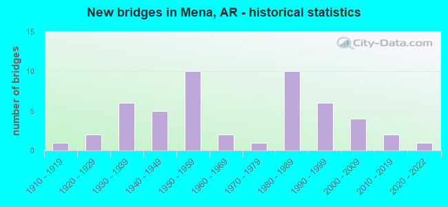
- New bridges - historical statistics
- 11910-1919
- 21920-1929
- 61930-1939
- 51940-1949
- 101950-1959
- 21960-1969
- 11970-1979
- 101980-1989
- 61990-1999
- 42000-2009
- 22010-2019
- 12020-2022

- Reconstructed bridges - Historical Statistics
- 11950-1959
- 01960-1969
- 11970-1979
- 11980-1989
- 11990-1999


- Bridge Condition - Deck
- 3.4%Excellent
- 10.3%Very good
- 27.6%Good
- 24.1%Satisfactory
- 34.5%Fair

- Bridge Condition - Superstructure
- 3.4%Excellent
- 6.9%Very good
- 20.7%Good
- 31.0%Satisfactory
- 34.5%Fair
- 3.4%Serious

- Bridge Condition - Substructure
- 3.4%Excellent
- 10.3%Very good
- 17.2%Good
- 24.1%Satisfactory
- 37.9%Fair
- 3.4%Poor
- 3.4%Serious

- Bridge Condition - Channel
- 16.0%Very good
- 36.0%Good
- 30.0%Satisfactory
- 18.0%Fair

- Bridge Condition - Culverts
- 23.8%Good
- 57.1%Satisfactory
- 19.0%Fair
Find on map >> Show street view
Structure Number: 192, Location: 0.20 MI N OF JCT SH 375 (Lat: 34.552453, Lng: -94.301319), Route carried "on" structure: US 71, Year Built: 1935, Status: Posted for load, Structure Length: 2.87m (9.42ft), Average Daily Traffic: 6,600 (year 2018), Truck Traffic: 1%, Average Future Daily Traffic: 8,596 (year 2028), Design Load: H 15, Features Intersected: McKinney Creek
Minimum Vertical Clearance: 30+ m (98+ ft), Kilometerpoint: 48.655, Lanes on structure: 2, Base Highway Network: Yes, Owner: State Highway Agency, Approaching Roadway Width: 10.1m (33.1ft), Material/Design: Steel, Design/Construction: Stringer/Multi-beam, Number Of Spans In Main Unit: 3, Length of Maximum Span: 9.4m (30.8ft), Curb or Sidewalk Widths: Left: 0.2m (0.7ft), Right: 0.2m (0.7ft), Curb-To-Curb Width: 7.4m (24.3ft), Out-to-Out Width: 7.8m (25.6ft)
Condition: Deck: Fair, Superstructure: Fair, Substructure: Satisfactory, Channel: Good, Operating Rating: 28.1 metric tons, Method Used To Determine Operating Rating: Load Factor (LF), Inventory Rating: 17.2 metric tons, Method Used To Determine Inventory Rating: Load Factor (LF), Structural Evaluation: Meets minimum limits, Deck Geometry: High priority of replacement, Waterway Adequacy: Equal to present desirable criteria, Approach Roadway Alignment: Better than present minimum criteria, Bridge Posting: Required (Relationship of Operating Rating to Maximum Legal Load: 10.0 - 19.9% below), Length Of Structure Improvement: 3.69m (12.11ft), Designated Inspection Frequency: Every 24 months, Critical Feature Inspection Frequency: Every 24 months, Inspection Date: April 2021, Roadway Improvement Cost: $400,000, Total Project Cost: $919,000, Deck Structure Type: Concrete Cast-file-Place, Wearing Surface/Protective System: Wearing Surface: Bituminous
Find on map >> Show street view
Structure Number: 2522, Location: 1.96 MI E US 71 (Lat: 34.561161, Lng: -94.210883), Route carried "on" structure: State highway 8, Year Built: 1949, Status: Open, Structure Length: 2.19m (7.19ft), Average Daily Traffic: 3,070 (year 2018), Truck Traffic: 1%, Average Future Daily Traffic: 4,858 (year 2028), Design Load: H 15, Features Intersected: Dallas Creek - Polk Co.
Minimum Vertical Clearance: 30+ m (98+ ft), Kilometerpoint: 3.154, Lanes on structure: 2, Base Highway Network: Yes, Owner: State Highway Agency, Approaching Roadway Width: 9.8m (32.2ft), Material/Design: Concrete, Design/Construction: Tee Beam, Number Of Spans In Main Unit: 2, Length of Maximum Span: 10.7m (35.1ft), Curb or Sidewalk Widths: Left: 0.4m (1.3ft), Right: 0.4m (1.3ft), Curb-To-Curb Width: 7.3m (24.0ft), Out-to-Out Width: 8.2m (26.9ft)
Condition: Deck: Satisfactory, Superstructure: Satisfactory, Substructure: Satisfactory, Channel: Good, Operating Rating: 39.9 metric tons, Method Used To Determine Operating Rating: Load Factor (LF), Inventory Rating: 24.5 metric tons, Method Used To Determine Inventory Rating: Load Factor (LF), Structural Evaluation: Equal to present minimum criteria, Deck Geometry: High priority of replacement, Waterway Adequacy: Equal to present desirable criteria, Approach Roadway Alignment: Equal to present desirable criteria, Length Of Structure Improvement: 2.96m (9.71ft), Designated Inspection Frequency: Every 24 months, Critical Feature Inspection Frequency: Every 24 months, Inspection Date: November 2021, Roadway Improvement Cost: $156,000, Total Project Cost: $396,000, Deck Structure Type: Concrete Cast-file-Place, Wearing Surface/Protective System: Wearing Surface: Monolithic Concrete
Find on map >> Show street view
Structure Number: 2523, Location: 5.08 MI SE US 71 (Lat: 34.543364, Lng: -94.165558), Route carried "on" structure: State highway 8, Year Built: 1949, Status: Open, Structure Length: 3.26m (10.70ft), Average Daily Traffic: 1,800 (year 2018), Truck Traffic: 7%, Average Future Daily Traffic: 2,118 (year 2028), Design Load: H 15, Features Intersected: Carter Creek - Polk Co.
Minimum Vertical Clearance: 30+ m (98+ ft), Kilometerpoint: 8.174, Lanes on structure: 2, Base Highway Network: Yes, Owner: State Highway Agency, Approaching Roadway Width: 9.8m (32.2ft), Material/Design: Concrete, Design/Construction: Tee Beam, Number Of Spans In Main Unit: 3, Length of Maximum Span: 10.7m (35.1ft), Curb-To-Curb Width: 7.3m (24.0ft), Out-to-Out Width: 8.3m (27.2ft)
Condition: Deck: Fair, Superstructure: Satisfactory, Substructure: Fair, Channel: Very good, Operating Rating: 39.0 metric tons, Method Used To Determine Operating Rating: Load Factor (LF), Inventory Rating: 23.6 metric tons, Method Used To Determine Inventory Rating: Load Factor (LF), Structural Evaluation: Somewhat better than minimum adequacy, Deck Geometry: Meets minimum limits, Waterway Adequacy: Equal to present desirable criteria, Approach Roadway Alignment: Equal to present desirable criteria, Length Of Structure Improvement: 4.08m (13.39ft), Designated Inspection Frequency: Every 24 months, Critical Feature Inspection Frequency: Every 24 months, Inspection Date: October 2021, Roadway Improvement Cost: $156,000, Total Project Cost: $471,000, Deck Structure Type: Concrete Cast-file-Place, Wearing Surface/Protective System: Wearing Surface: Monolithic Concrete
Find on map >> Show street view
Structure Number: 3885, Location: 4.95 M NE JCT SH 8 (Lat: 34.643344, Lng: -94.199181), Route carried "on" structure: US 71, Year Built: 1965, Status: Open, Structure Length: 6.16m (20.21ft), Average Daily Traffic: 3,100 (year 2018), Truck Traffic: 19%, Average Future Daily Traffic: 3,737 (year 2028), Design Load: H 20, Features Intersected: Ouachita River
Minimum Vertical Clearance: 30+ m (98+ ft), Kilometerpoint: 9.316, Lanes on structure: 2, Base Highway Network: Yes, Owner: State Highway Agency, Approaching Roadway Width: 9.4m (30.8ft), Skew: 1 degrees, Material/Design: Steel, Design/Construction: Stringer/Multi-beam, Number Of Spans In Main Unit: 4, Length of Maximum Span: 15.2m (49.9ft), Curb or Sidewalk Widths: Left: 0.5m (1.6ft), Right: 0.5m (1.6ft), Curb-To-Curb Width: 8.5m (27.9ft), Out-to-Out Width: 10.2m (33.5ft)
Condition: Deck: Fair, Superstructure: Fair, Substructure: Fair, Channel: Good, Operating Rating: 54.4 metric tons, Method Used To Determine Operating Rating: Load Factor (LF), Inventory Rating: 32.7 metric tons, Method Used To Determine Inventory Rating: Load Factor (LF), Structural Evaluation: Somewhat better than minimum adequacy, Deck Geometry: Meets minimum limits, Waterway Adequacy: Equal to present desirable criteria, Approach Roadway Alignment: Equal to present desirable criteria, Designated Inspection Frequency: Every 24 months, Critical Feature Inspection Frequency: Every 24 months, Inspection Date: April 2021, Deck Structure Type: Concrete Cast-file-Place, Wearing Surface/Protective System: Wearing Surface: Monolithic Concrete
Find on map >> Show street view
Structure Number: 4323, Location: 1.80 M E SH 8 & CO RD 54 (Lat: 34.570686, Lng: -94.188019), Route carried "on" structure: County highway 54, Year Built: 1977, Status: Open, Structure Length: 4.36m (14.30ft), Average Daily Traffic: 696 (year 2018), Truck Traffic: 1%, Average Future Daily Traffic: 107 (year 2007), Design Load: H 15, Features Intersected: Prairie Creek Polk Co.
Minimum Vertical Clearance: 30+ m (98+ ft), Kilometerpoint: 2.895, Lanes on structure: 2, Owner: County Highway Agency, Approaching Roadway Width: 7.9m (25.9ft), Material/Design: Steel, Design/Construction: Stringer/Multi-beam, Number Of Spans In Main Unit: 3, Length of Maximum Span: 14.3m (46.9ft), Curb-To-Curb Width: 7.3m (24.0ft), Out-to-Out Width: 8.1m (26.6ft)
Condition: Deck: Very good, Superstructure: Good, Substructure: Satisfactory, Channel: Good, Operating Rating: 36.3 metric tons, Method Used To Determine Operating Rating: Load Factor (LF), Inventory Rating: 21.8 metric tons, Method Used To Determine Inventory Rating: Load Factor (LF), Structural Evaluation: Somewhat better than minimum adequacy, Deck Geometry: Meets minimum limits, Waterway Adequacy: Better than present minimum criteria, Approach Roadway Alignment: Better than present minimum criteria, Designated Inspection Frequency: Every 24 months, Critical Feature Inspection Frequency: Every 24 months, Other Special Inspection Frequency: Every 24 months, Inspection Date: June 2020, Other Special Inspection Date: June 2021, Deck Structure Type: Concrete Cast-file-Place, Wearing Surface/Protective System: Wearing Surface: Monolithic Concrete
Find on map >> Show street view
Structure Number: 4673, Location: 3.6 MI E US 71 (Lat: 34.608489, Lng: -94.165908), Route carried "on" structure: County highway 74, Year Built: 1992, Status: Open, Structure Length: 3.78m (12.40ft), Average Daily Traffic: 664 (year 2018), Truck Traffic: 1%, Average Future Daily Traffic: 152 (year 2007), Design Load: HS 20, Features Intersected: Chances Creek Polk Co.
Minimum Vertical Clearance: 30+ m (98+ ft), Kilometerpoint: 9.220, Lanes on structure: 2, Owner: County Highway Agency, Approaching Roadway Width: 8.5m (27.9ft), Material/Design: Concrete, Design/Construction: Channel Beam, Number Of Spans In Main Unit: 4, Length of Maximum Span: 9.4m (30.8ft), Curb-To-Curb Width: 7.5m (24.6ft), Out-to-Out Width: 8.2m (26.9ft)
Condition: Deck: Satisfactory, Superstructure: Satisfactory, Substructure: Very good, Channel: Very good, Operating Rating: 54.4 metric tons, Method Used To Determine Operating Rating: Load Factor (LF), Inventory Rating: 32.7 metric tons, Method Used To Determine Inventory Rating: Load Factor (LF), Structural Evaluation: Equal to present minimum criteria, Deck Geometry: Meets minimum limits, Waterway Adequacy: Equal to present desirable criteria, Approach Roadway Alignment: Equal to present desirable criteria, Designated Inspection Frequency: Every 24 months, Critical Feature Inspection Frequency: Every 24 months, Inspection Date: May 2020, Deck Structure Type: Concrete Precast Panels, Wearing Surface/Protective System: Wearing Surface: Monolithic Concrete
Find on map >> Show street view
Structure Number: 4678, Location: 1.6 MI EAST US 71 (Lat: 34.612700, Lng: -94.191314), Route carried "on" structure: County highway 178, Year Built: 1992, Status: Open, Structure Length: 2.83m (9.28ft), Average Daily Traffic: 56 (year 2018), Truck Traffic: 1%, Average Future Daily Traffic: 72 (year 2007), Design Load: HS 20, Features Intersected: Lewis Creek Polk Co.
Minimum Vertical Clearance: 30+ m (98+ ft), Kilometerpoint: 2.589, Lanes on structure: 2, Owner: County Highway Agency, Approaching Roadway Width: 7.3m (24.0ft), Material/Design: Concrete, Design/Construction: Channel Beam, Number Of Spans In Main Unit: 3, Length of Maximum Span: 9.4m (30.8ft), Curb-To-Curb Width: 7.5m (24.6ft), Out-to-Out Width: 8.2m (26.9ft)
Condition: Deck: Good, Superstructure: Satisfactory, Substructure: Good, Channel: Fair, Operating Rating: 54.4 metric tons, Method Used To Determine Operating Rating: Load Factor (LF), Inventory Rating: 32.7 metric tons, Method Used To Determine Inventory Rating: Load Factor (LF), Structural Evaluation: Equal to present minimum criteria, Deck Geometry: Equal to present minimum criteria, Waterway Adequacy: Equal to present desirable criteria, Approach Roadway Alignment: Equal to present desirable criteria, Designated Inspection Frequency: Every 24 months, Critical Feature Inspection Frequency: Every 24 months, Inspection Date: May 2020, Deck Structure Type: Concrete Precast Panels, Wearing Surface/Protective System: Wearing Surface: Monolithic Concrete
Find on map >> Show street view
Structure Number: 4827, Location: 2.8 MI. NE OF US 88 (Lat: 34.606797, Lng: -94.168350), Route carried "on" structure: County highway 74, Year Built: 2001, Status: Open, Structure Length: 9.24m (30.31ft), Average Daily Traffic: 664 (year 2018), Truck Traffic: 1%, Average Future Daily Traffic: 152 (year 2007), Design Load: HS 20, Features Intersected: Ouachita River Polk Co.
Minimum Vertical Clearance: 30+ m (98+ ft), Kilometerpoint: 9.543, Lanes on structure: 2, Owner: County Highway Agency, Approaching Roadway Width: 6.1m (20.0ft), Material/Design: Steel continuous, Design/Construction: Stringer/Multi-beam, Number Of Spans In Main Unit: 5, Length of Maximum Span: 19.8m (65.0ft), Curb-To-Curb Width: 7.3m (24.0ft), Out-to-Out Width: 8.0m (26.2ft)
Condition: Deck: Good, Superstructure: Very good, Substructure: Good, Channel: Satisfactory, Operating Rating: 54.4 metric tons, Method Used To Determine Operating Rating: Load Factor (LF), Inventory Rating: 32.7 metric tons, Method Used To Determine Inventory Rating: Load Factor (LF), Structural Evaluation: Better than present minimum criteria, Deck Geometry: Meets minimum limits, Waterway Adequacy: Equal to present desirable criteria, Approach Roadway Alignment: Equal to present desirable criteria, Designated Inspection Frequency: Every 24 months, Critical Feature Inspection Frequency: Every 24 months, Inspection Date: December 2020, Deck Structure Type: Concrete Cast-file-Place, Wearing Surface/Protective System: Wearing Surface: Monolithic Concrete, Deck Protection: Bituminous
Find on map >> Show street view
Structure Number: 6091, Location: 4.86 MI NW JCT US 71 (Lat: 34.574694, Lng: -94.309581), Route carried "on" structure: State highway 375, Year Built: 1985, Status: Open, Structure Length: 3.20m (10.50ft), Average Daily Traffic: 440 (year 2018), Truck Traffic: 1%, Average Future Daily Traffic: 548 (year 2028), Design Load: H 20, Features Intersected: Rock Creek Polk County
Minimum Vertical Clearance: 30+ m (98+ ft), Kilometerpoint: 7.466, Lanes on structure: 2, Owner: State Highway Agency, Approaching Roadway Width: 8.5m (27.9ft), Skew: 3 degrees, Material/Design: Concrete, Design/Construction: Slab, Number Of Spans In Main Unit: 3, Length of Maximum Span: 10.7m (35.1ft), Curb-To-Curb Width: 8.5m (27.9ft), Out-to-Out Width: 9.4m (30.8ft)
Condition: Deck: Satisfactory, Superstructure: Satisfactory, Substructure: Satisfactory, Channel: Good, Operating Rating: 51.7 metric tons, Method Used To Determine Operating Rating: Load Factor (LF), Inventory Rating: 30.8 metric tons, Method Used To Determine Inventory Rating: Load Factor (LF), Structural Evaluation: Equal to present minimum criteria, Deck Geometry: Somewhat better than minimum adequacy, Waterway Adequacy: Equal to present desirable criteria, Approach Roadway Alignment: Equal to present desirable criteria, Designated Inspection Frequency: Every 24 months, Critical Feature Inspection Frequency: Every 24 months, Inspection Date: Febuary 2021, Deck Structure Type: Concrete Cast-file-Place, Wearing Surface/Protective System: Wearing Surface: Monolithic Concrete
Find on map >> Show street view
Structure Number: 6092, Location: 2.77 MI W MENA CITY LIMIT (Lat: 34.574719, Lng: -94.308831), Route carried "on" structure: State highway 375, Year Built: 1985, Status: Open, Structure Length: 3.20m (10.50ft), Average Daily Traffic: 440 (year 2018), Truck Traffic: 1%, Average Future Daily Traffic: 548 (year 2028), Design Load: H 20, Features Intersected: Rock Creek Polk County
Minimum Vertical Clearance: 30+ m (98+ ft), Kilometerpoint: 7.530, Lanes on structure: 2, Owner: State Highway Agency, Approaching Roadway Width: 8.5m (27.9ft), Skew: 3 degrees, Material/Design: Concrete, Design/Construction: Slab, Number Of Spans In Main Unit: 3, Length of Maximum Span: 10.7m (35.1ft), Curb-To-Curb Width: 8.5m (27.9ft), Out-to-Out Width: 9.4m (30.8ft)
Condition: Deck: Satisfactory, Superstructure: Satisfactory, Substructure: Satisfactory, Channel: Good, Operating Rating: 50.8 metric tons, Method Used To Determine Operating Rating: Load Factor (LF), Inventory Rating: 30.8 metric tons, Method Used To Determine Inventory Rating: Load Factor (LF), Structural Evaluation: Equal to present minimum criteria, Deck Geometry: Somewhat better than minimum adequacy, Waterway Adequacy: Equal to present desirable criteria, Approach Roadway Alignment: Equal to present desirable criteria, Designated Inspection Frequency: Every 24 months, Critical Feature Inspection Frequency: Every 24 months, Inspection Date: Febuary 2021, Deck Structure Type: Concrete Cast-file-Place, Wearing Surface/Protective System: Wearing Surface: Monolithic Concrete
Find on map >> Show street view
Structure Number: 6093, Location: 5.57 MI NW JCT US 71 (Lat: 34.574469, Lng: -94.297747), Route carried "on" structure: State highway 375, Year Built: 1985, Status: Open, Structure Length: 3.20m (10.50ft), Average Daily Traffic: 440 (year 2018), Truck Traffic: 1%, Average Future Daily Traffic: 548 (year 2028), Design Load: H 20, Features Intersected: Merren Creek Polk Co.
Minimum Vertical Clearance: 30+ m (98+ ft), Kilometerpoint: 8.544, Lanes on structure: 2, Owner: State Highway Agency, Approaching Roadway Width: 8.5m (27.9ft), Skew: 3 degrees, Material/Design: Concrete, Design/Construction: Slab, Number Of Spans In Main Unit: 3, Length of Maximum Span: 10.7m (35.1ft), Curb-To-Curb Width: 8.5m (27.9ft), Out-to-Out Width: 9.4m (30.8ft)
Condition: Deck: Satisfactory, Superstructure: Satisfactory, Substructure: Satisfactory, Channel: Good, Operating Rating: 51.7 metric tons, Method Used To Determine Operating Rating: Load Factor (LF), Inventory Rating: 30.8 metric tons, Method Used To Determine Inventory Rating: Load Factor (LF), Structural Evaluation: Equal to present minimum criteria, Deck Geometry: Somewhat better than minimum adequacy, Waterway Adequacy: Equal to present desirable criteria, Approach Roadway Alignment: Equal to present desirable criteria, Designated Inspection Frequency: Every 24 months, Critical Feature Inspection Frequency: Every 24 months, Inspection Date: Febuary 2021, Deck Structure Type: Concrete Cast-file-Place, Wearing Surface/Protective System: Wearing Surface: Monolithic Concrete
Find on map >> Show street view
Structure Number: 16154, Location: 0.17 E SH 375 (Lat: 34.564275, Lng: -94.320214), Route carried "on" structure: County highway 41, Year Built: 1935, Year Reconstructed: 1999, Status: Posted for load, Structure Length: 1.04m (3.41ft), Average Daily Traffic: 195 (year 2018), Truck Traffic: 1%, Average Future Daily Traffic: 108 (year 2007), Features Intersected: Rock Creek Relief - Polk
Minimum Vertical Clearance: 30+ m (98+ ft), Kilometerpoint: 0.274, Lanes on structure: 1, Owner: County Highway Agency, Approaching Roadway Width: 4.3m (14.1ft), Material/Design: Steel, Design/Construction: Stringer/Multi-beam, Number Of Spans In Main Unit: 1, Length of Maximum Span: 9.3m (30.5ft), Curb-To-Curb Width: 3.7m (12.1ft), Out-to-Out Width: 3.7m (12.1ft)
Condition: Deck: Satisfactory, Superstructure: Satisfactory, Substructure: Fair, Channel: Good, Operating Rating: 26.3 metric tons, Method Used To Determine Operating Rating: Load Factor (LF), Inventory Rating: 16.3 metric tons, Method Used To Determine Inventory Rating: Load Factor (LF), Structural Evaluation: Somewhat better than minimum adequacy, Deck Geometry: High priority of replacement, Waterway Adequacy: Somewhat better than minimum adequacy, Approach Roadway Alignment: Equal to present minimum criteria, Bridge Posting: Required (Relationship of Operating Rating to Maximum Legal Load: 20.0 - 29.9% below), Length Of Structure Improvement: 1.58m (5.18ft), Designated Inspection Frequency: Every 24 months, Critical Feature Inspection Frequency: Every 24 months, Inspection Date: October 2021, Roadway Improvement Cost: $109,000, Total Project Cost: $211,000, Deck Structure Type: Wood or Timber, Wearing Surface/Protective System: Wearing Surface: Wood or Timber
Find on map >> Show street view
Structure Number: 16197, Location: 2.65 M SW US71 & CORD 76 (Lat: 34.630131, Lng: -94.187364), Route carried "on" structure: County highway 76, Year Built: 1914, Status: Posted for load, Structure Length: 4.54m (14.90ft), Average Daily Traffic: 220 (year 2018), Truck Traffic: 3%, Average Future Daily Traffic: 72 (year 2007), Features Intersected: Quachita River-Polk Co.
Minimum Vertical Clearance: 30+ m (98+ ft), Kilometerpoint: 4.265, Lanes on structure: 1, Owner: County Highway Agency, Approaching Roadway Width: 4.9m (16.1ft), Material/Design: Steel, Design/Construction: Truss - Thru, Number Of Spans In Main Unit: 1, Number Of Approach Spans: 5, Length of Maximum Span: 24.4m (80.1ft), Curb-To-Curb Width: 3.5m (11.5ft), Out-to-Out Width: 3.6m (11.8ft)
Condition: Deck: Fair, Superstructure: Serious, Substructure: Fair, Channel: Satisfactory, Operating Rating: 2.7 metric tons, Method Used To Determine Operating Rating: Allowable Stress (AS), Inventory Rating: 1.8 metric tons, Method Used To Determine Inventory Rating: Allowable Stress (AS), Structural Evaluation: High priority of replacement, Deck Geometry: High priority of replacement, Waterway Adequacy: Equal to present minimum criteria, Approach Roadway Alignment: Meets minimum limits, Bridge Posting: Required (Relationship of Operating Rating to Maximum Legal Load: > 39.9% below), Length Of Structure Improvement: 5.46m (17.91ft), Designated Inspection Frequency: Every 24 months, Critical Feature Inspection Frequency: Every 24 months, Inspection Date: May 2021, Critical Feature Inspection Date: May 2021, Roadway Improvement Cost: $109,000, Total Project Cost: $387,000, Deck Structure Type: Wood or Timber, Wearing Surface/Protective System: Wearing Surface: Wood or Timber
Find on map >> Show street view
Structure Number: 16218, Location: Acorn (Lat: 34.643775, Lng: -94.199347), Route carried "on" structure: County highway 109, Year Built: 1929, Status: Posted for load, Structure Length: 4.05m (13.29ft), Average Daily Traffic: 40 (year 2018), Truck Traffic: 1%, Average Future Daily Traffic: 25 (year 2007), Design Load: H 15, Features Intersected: Quachita River - Polk Co
Minimum Vertical Clearance: 30+ m (98+ ft), Kilometerpoint: 0.080, Lanes on structure: 2, Owner: County Highway Agency, Approaching Roadway Width: 6.7m (22.0ft), Material/Design: Steel, Design/Construction: Truss - Thru, Number Of Spans In Main Unit: 1, Number Of Approach Spans: 2, Length of Maximum Span: 22.3m (73.2ft), Curb or Sidewalk Widths: Left: 0.2m (0.7ft), Right: 0.2m (0.7ft), Curb-To-Curb Width: 6.1m (20.0ft), Out-to-Out Width: 7.2m (23.6ft)
Condition: Deck: Fair, Superstructure: Fair, Substructure: Poor, Channel: Satisfactory, Operating Rating: 15.4 metric tons, Method Used To Determine Operating Rating: Allowable Stress (AS), Inventory Rating: 10.0 metric tons, Method Used To Determine Inventory Rating: Allowable Stress (AS), Structural Evaluation: High priority of replacement, Deck Geometry: Somewhat better than minimum adequacy, Waterway Adequacy: Equal to present desirable criteria, Approach Roadway Alignment: Equal to present minimum criteria, Bridge Posting: Required (Relationship of Operating Rating to Maximum Legal Load: 30.0 - 39.9% below), Length Of Structure Improvement: 4.94m (16.21ft), Designated Inspection Frequency: Every 24 months, Critical Feature Inspection Frequency: Every 24 months, Inspection Date: July 2021, Critical Feature Inspection Date: July 2021, Roadway Improvement Cost: $109,000, Total Project Cost: $368,000, Deck Structure Type: Concrete Cast-file-Place, Wearing Surface/Protective System: Wearing Surface: Bituminous
Find on map >> Show street view
Structure Number: 16219, Location: ACORN (Lat: 34.644072, Lng: -94.198683), Route carried "on" structure: County highway 109, Year Built: 1929, Status: Open, Structure Length: 2.74m (8.99ft), Average Daily Traffic: 37 (year 2018), Truck Traffic: 1%, Average Future Daily Traffic: 25 (year 2007), Design Load: H 15, Features Intersected: Ouachita River Relief
Minimum Vertical Clearance: 30+ m (98+ ft), Kilometerpoint: 0.161, Lanes on structure: 2, Owner: County Highway Agency, Approaching Roadway Width: 6.7m (22.0ft), Material/Design: Concrete, Design/Construction: Tee Beam, Number Of Spans In Main Unit: 3, Length of Maximum Span: 9.1m (29.9ft), Curb or Sidewalk Widths: Left: 0.2m (0.7ft), Right: 0.2m (0.7ft), Curb-To-Curb Width: 6.1m (20.0ft), Out-to-Out Width: 7.0m (23.0ft)
Condition: Deck: Good, Superstructure: Fair, Substructure: Satisfactory, Channel: Good, Operating Rating: 36.3 metric tons, Method Used To Determine Operating Rating: Load Factor (LF), Inventory Rating: 21.8 metric tons, Method Used To Determine Inventory Rating: Load Factor (LF), Structural Evaluation: Somewhat better than minimum adequacy, Deck Geometry: Somewhat better than minimum adequacy, Waterway Adequacy: Equal to present desirable criteria, Approach Roadway Alignment: Somewhat better than minimum adequacy, Designated Inspection Frequency: Every 24 months, Critical Feature Inspection Frequency: Every 24 months, Inspection Date: July 2020, Deck Structure Type: Concrete Cast-file-Place, Wearing Surface/Protective System: Wearing Surface: Bituminous
Find on map >> Show street view
Structure Number: 18208, Location: 0.58 M SW US 71 & CO RD77 (Lat: 34.602086, Lng: -94.211572), Route carried "on" structure: County highway 77, Year Built: 1939, Year Reconstructed: 1991, Status: Posted for load, Structure Length: 0.85m (2.79ft), Average Daily Traffic: 155 (year 2018), Truck Traffic: 1%, Average Future Daily Traffic: 125 (year 2007), Features Intersected: Brier Creek - Polk Co.
Minimum Vertical Clearance: 30+ m (98+ ft), Kilometerpoint: 1.947, Lanes on structure: 1, Owner: County Highway Agency, Approaching Roadway Width: 4.3m (14.1ft), Material/Design: Wood or Timber, Design/Construction: Stringer/Multi-beam, Number Of Spans In Main Unit: 1, Length of Maximum Span: 7.7m (25.3ft), Curb-To-Curb Width: 4.9m (16.1ft), Out-to-Out Width: 4.9m (16.1ft)
Condition: Deck: Fair, Superstructure: Fair, Substructure: Serious, Channel: Satisfactory, Operating Rating: 18.1 metric tons, Method Used To Determine Operating Rating: Load Factor (LF), Inventory Rating: 12.7 metric tons, Method Used To Determine Inventory Rating: Load Factor (LF), Structural Evaluation: High priority of corrective action, Deck Geometry: High priority of replacement, Waterway Adequacy: Somewhat better than minimum adequacy, Approach Roadway Alignment: Equal to present minimum criteria, Bridge Posting: Required (Relationship of Operating Rating to Maximum Legal Load: > 39.9% below), Length Of Structure Improvement: 1.55m (5.09ft), Designated Inspection Frequency: Every 24 months, Critical Feature Inspection Frequency: Every 24 months, Inspection Date: January 2022, Roadway Improvement Cost: $109,000, Total Project Cost: $210,000, Deck Structure Type: Wood or Timber, Wearing Surface/Protective System: Wearing Surface: Wood or Timber
Find on map >> Show street view
Structure Number: 18964, Location: 0.6 MI S JCT US 71 (Lat: 34.564803, Lng: -94.239553), Route carried "on" structure: City street 4780, Year Built: 1935, Year Reconstructed: 1955, Status: Open, Structure Length: 0.79m (2.59ft), Average Daily Traffic: 344 (year 2018), Truck Traffic: 1%, Average Future Daily Traffic: 779 (year 2007), Design Load: H 10, Features Intersected: Casy Glen Creek- Mena, Facility Carried by Structure: E Bethesda Rd
Minimum Vertical Clearance: 30+ m (98+ ft), Kilometerpoint: 8.930, Lanes on structure: 2, Owner: City or Municipal Highway Agency, Approaching Roadway Width: 6.1m (20.0ft), Material/Design: Concrete, Design/Construction: Arch - Deck, Number Of Spans In Main Unit: 2, Length of Maximum Span: 3.4m (11.2ft), Curb or Sidewalk Widths: Left: 0.2m (0.7ft), Right: 0.2m (0.7ft), Curb-To-Curb Width: 6.9m (22.6ft), Out-to-Out Width: 7.3m (24.0ft)
Condition: Deck: Fair, Superstructure: Fair, Substructure: Fair, Channel: Satisfactory, Operating Rating: 28.1 metric tons, Method Used To Determine Operating Rating: Load Factor (LF), Inventory Rating: 17.2 metric tons, Method Used To Determine Inventory Rating: Load Factor (LF), Structural Evaluation: Somewhat better than minimum adequacy, Deck Geometry: Meets minimum limits, Waterway Adequacy: Equal to present minimum criteria, Approach Roadway Alignment: Equal to present minimum criteria, Length Of Structure Improvement: 0.79m (2.59ft), Designated Inspection Frequency: Every 24 months, Critical Feature Inspection Frequency: Every 24 months, Inspection Date: Febuary 2021, Total Project Cost: $27,000, Deck Structure Type: Concrete Cast-file-Place, Wearing Surface/Protective System: Wearing Surface: Bituminous
Find on map >> Show street view
Structure Number: 20204, Location: 0.1 SO SH 375 (Lat: 34.573344, Lng: -94.301847), Route carried "on" structure: County highway 41, Year Built: 1982, Status: Posted for load, Structure Length: 1.83m (6.00ft), Average Daily Traffic: 195 (year 2018), Truck Traffic: 1%, Average Future Daily Traffic: 110 (year 2007), Features Intersected: Merren Creek-Polk County
Minimum Vertical Clearance: 30+ m (98+ ft), Kilometerpoint: 3.347, Lanes on structure: 1, Owner: County Highway Agency, Approaching Roadway Width: 4.9m (16.1ft), Material/Design: Concrete, Design/Construction: Channel Beam, Number Of Spans In Main Unit: 3, Length of Maximum Span: 6.1m (20.0ft), Curb or Sidewalk Widths: Left: 0.1m (0.3ft), Right: 0.1m (0.3ft), Curb-To-Curb Width: 4.5m (14.8ft), Out-to-Out Width: 4.9m (16.1ft)
Condition: Deck: Satisfactory, Superstructure: Fair, Substructure: Fair, Channel: Fair, Operating Rating: 2.7 metric tons, Method Used To Determine Operating Rating: Load Factor (LF), Structural Evaluation: High priority of corrective action, Deck Geometry: High priority of replacement, Waterway Adequacy: Meets minimum limits, Approach Roadway Alignment: Equal to present minimum criteria, Bridge Posting: Required (Relationship of Operating Rating to Maximum Legal Load: > 39.9% below), Length Of Structure Improvement: 1.83m (6.00ft), Designated Inspection Frequency: Every 24 months, Critical Feature Inspection Frequency: Every 24 months, Inspection Date: Febuary 2021, Total Project Cost: $43,000, Deck Structure Type: Concrete Cast-file-Place, Wearing Surface/Protective System: Wearing Surface: Bituminous
Find on map >> Show street view
Structure Number: 20438, Location: 0.71 MI N JCT CR 167 (Lat: 34.559378, Lng: -94.311064), Route carried "on" structure: County highway 167, Year Built: 1985, Status: Open, Structure Length: 0.94m (3.08ft), Average Daily Traffic: 126 (year 1987), Truck Traffic: 1%, Average Future Daily Traffic: 157 (year 2007), Features Intersected: Creek Polk County
Minimum Vertical Clearance: 30+ m (98+ ft), Kilometerpoint: 1.127, Lanes on structure: 2, Owner: County Highway Agency, Approaching Roadway Width: 5.5m (18.0ft), Material/Design: Concrete, Design/Construction: Channel Beam, Number Of Spans In Main Unit: 1, Length of Maximum Span: 8.5m (27.9ft), Curb or Sidewalk Widths: Left: 0.2m (0.7ft), Right: 0.2m (0.7ft), Curb-To-Curb Width: 7.4m (24.3ft), Out-to-Out Width: 7.8m (25.6ft)
Condition: Deck: Good, Superstructure: Satisfactory, Substructure: Good, Channel: Good, Operating Rating: 54.4 metric tons, Method Used To Determine Operating Rating: Load Factor (LF), Inventory Rating: 32.7 metric tons, Method Used To Determine Inventory Rating: Load Factor (LF), Structural Evaluation: Equal to present minimum criteria, Deck Geometry: Somewhat better than minimum adequacy, Waterway Adequacy: Better than present minimum criteria, Approach Roadway Alignment: Equal to present minimum criteria, Designated Inspection Frequency: Every 24 months, Critical Feature Inspection Frequency: Every 24 months, Inspection Date: May 2020, Deck Structure Type: Concrete Precast Panels, Wearing Surface/Protective System: Wearing Surface: Bituminous
Find on map >> Show street view
Structure Number: 21499, Location: 1.08 S US 71 (Lat: 34.568247, Lng: -94.231803), Route carried "on" structure: City street 38150, Year Built: 1994, Status: Open, Structure Length: 0.64m (2.10ft), Average Daily Traffic: 200 (year 2018), Truck Traffic: 2%, Average Future Daily Traffic: 300 (year 2038), Features Intersected: Prairie Creek Polk Co., Facility Carried by Structure: South Mena Street
Minimum Vertical Clearance: 30+ m (98+ ft), Kilometerpoint: 1.738, Lanes on structure: 2, Owner: City or Municipal Highway Agency, Approaching Roadway Width: 4.9m (16.1ft), Material/Design: Steel, Design/Construction: Culvert, Number Of Spans In Main Unit: 2, Length of Maximum Span: 2.7m (8.9ft), Curb or Sidewalk Widths: Left: 0.3m (1.0ft), Right: 0.3m (1.0ft), Curb-To-Curb Width: 7.3m (24.0ft), Out-to-Out Width: 7.9m (25.9ft)
Condition: Channel: Satisfactory, Culverts: Fair, Operating Rating: 54.4 metric tons, Method Used To Determine Operating Rating: Load Factor (LF), Inventory Rating: 32.7 metric tons, Method Used To Determine Inventory Rating: Load Factor (LF), Structural Evaluation: Somewhat better than minimum adequacy, Deck Geometry: Somewhat better than minimum adequacy, Waterway Adequacy: Equal to present minimum criteria, Approach Roadway Alignment: Equal to present desirable criteria, Designated Inspection Frequency: Every 24 months, Critical Feature Inspection Frequency: Every 24 months, Inspection Date: May 2020
Find on map >> Show street view
Structure Number: 21586, Location: JCT U.S. 71&CHERRY ST (Lat: 34.586522, Lng: -94.227050), Route carried "on" structure: City street 10580, Year Built: 1995, Status: Open, Structure Length: 0.94m (3.08ft), Average Daily Traffic: 2,193 (year 2018), Truck Traffic: 1%, Average Future Daily Traffic: 37 (year 2007), Design Load: HS 20, Features Intersected: Ward Creek Polk Co., Facility Carried by Structure: Cherry Street
Minimum Vertical Clearance: 30+ m (98+ ft), Kilometerpoint: 0.002, Lanes on structure: 3, Owner: City or Municipal Highway Agency, Approaching Roadway Width: 11.9m (39.0ft), Material/Design: Concrete, Design/Construction: Channel Beam, Number Of Spans In Main Unit: 1, Length of Maximum Span: 8.8m (28.9ft), Curb or Sidewalk Widths: Left: 0.0m, Right: 1.1m (3.6ft), Curb-To-Curb Width: 11.8m (38.7ft), Out-to-Out Width: 14.0m (45.9ft)
Condition: Deck: Good, Superstructure: Good, Substructure: Very good, Channel: Very good, Operating Rating: 54.4 metric tons, Method Used To Determine Operating Rating: Load Factor (LF), Inventory Rating: 32.7 metric tons, Method Used To Determine Inventory Rating: Load Factor (LF), Structural Evaluation: Better than present minimum criteria, Deck Geometry: High priority of corrective action, Waterway Adequacy: Equal to present desirable criteria, Approach Roadway Alignment: Equal to present minimum criteria, Designated Inspection Frequency: Every 24 months, Critical Feature Inspection Frequency: Every 24 months, Inspection Date: December 2020, Deck Structure Type: Concrete Precast Panels, Wearing Surface/Protective System: Wearing Surface: Monolithic Concrete
Find on map >> Show street view
Structure Number: 22033, Location: 0.10 M SE CR 44 & 56 (Lat: 34.536956, Lng: -94.191039), Route carried "on" structure: County highway 56, Year Built: 1998, Status: Open, Structure Length: 0.94m (3.08ft), Average Daily Traffic: 393 (year 2018), Truck Traffic: 1%, Average Future Daily Traffic: 72 (year 2007), Features Intersected: Carter Creek Polk Co.
Minimum Vertical Clearance: 30+ m (98+ ft), Kilometerpoint: 0.161, Lanes on structure: 2, Owner: County Highway Agency, Approaching Roadway Width: 7.3m (24.0ft), Material/Design: Concrete, Design/Construction: Channel Beam, Number Of Spans In Main Unit: 1, Length of Maximum Span: 8.5m (27.9ft), Curb or Sidewalk Widths: Left: 0.2m (0.7ft), Right: 0.2m (0.7ft), Curb-To-Curb Width: 7.3m (24.0ft), Out-to-Out Width: 7.6m (24.9ft)
Condition: Deck: Good, Superstructure: Good, Substructure: Good, Channel: Good, Operating Rating: 54.4 metric tons, Method Used To Determine Operating Rating: Load Factor (LF), Inventory Rating: 32.7 metric tons, Method Used To Determine Inventory Rating: Load Factor (LF), Structural Evaluation: Better than present minimum criteria, Waterway Adequacy: Better than present minimum criteria, Approach Roadway Alignment: Equal to present desirable criteria, Designated Inspection Frequency: Every 24 months, Critical Feature Inspection Frequency: Every 24 months, Inspection Date: May 2020, Deck Structure Type: Concrete Precast Panels, Wearing Surface/Protective System: Wearing Surface: Monolithic Concrete
Find on map >> Show street view
Structure Number: 22476, Location: N. JCT. U.S.71 & MORROW S (Lat: 34.586969, Lng: -94.222528), Route carried "on" structure: City street 39630, Year Built: 2003, Status: Open, Structure Length: 1.19m (3.90ft), Average Daily Traffic: 3,500 (year 2018), Truck Traffic: 2%, Average Future Daily Traffic: 125 (year 2007), Design Load: H 20, Features Intersected: Ward Creek- City of Mena, Facility Carried by Structure: Morrow Street
Minimum Vertical Clearance: 30+ m (98+ ft), Kilometerpoint: 0.064, Lanes on structure: 2, Owner: City or Municipal Highway Agency, Approaching Roadway Width: 11.3m (37.1ft), Material/Design: Concrete, Design/Construction: Culvert, Number Of Spans In Main Unit: 4, Length of Maximum Span: 3.0m (9.8ft), Curb or Sidewalk Widths: Left: 1.8m (5.9ft), Right: 1.8m (5.9ft), Curb-To-Curb Width: 12.0m (39.4ft), Out-to-Out Width: 15.8m (51.8ft)
Condition: Channel: Very good, Culverts: Satisfactory, Operating Rating: 30.8 metric tons, Method Used To Determine Operating Rating: Load Factor (LF), Inventory Rating: 19.1 metric tons, Method Used To Determine Inventory Rating: Load Factor (LF), Structural Evaluation: Somewhat better than minimum adequacy, Deck Geometry: Somewhat better than minimum adequacy, Waterway Adequacy: Equal to present desirable criteria, Approach Roadway Alignment: Equal to present desirable criteria, Designated Inspection Frequency: Every 24 months, Critical Feature Inspection Frequency: Every 24 months, Inspection Date: May 2021, Deck Structure Type: Other
Find on map >> Show street view
Structure Number: 23316, Location: 0.9 Mi NE Jct Hwy 71 (Lat: 34.616028, Lng: -94.194778), Route carried "on" structure: County highway 76, Year Built: 2009, Status: Open, Structure Length: 2.29m (7.51ft), Average Daily Traffic: 220 (year 2018), Truck Traffic: 3%, Average Future Daily Traffic: 315 (year 2028), Features Intersected: Lewis Creek Polk Co.
Minimum Vertical Clearance: 30+ m (98+ ft), Kilometerpoint: 6.275, Lanes on structure: 2, Owner: County Highway Agency, Approaching Roadway Width: 6.3m (20.7ft), Skew: 3 degrees, Material/Design: Concrete, Design/Construction: Culvert, Number Of Spans In Main Unit: 6, Length of Maximum Span: 3.7m (12.1ft)
Condition: Channel: Fair, Culverts: Good, Operating Rating: 26.3 metric tons, Method Used To Determine Operating Rating: Load Factor (LF), Inventory Rating: 16.3 metric tons, Method Used To Determine Inventory Rating: Load Factor (LF), Structural Evaluation: Somewhat better than minimum adequacy, Waterway Adequacy: Equal to present minimum criteria, Approach Roadway Alignment: Better than present minimum criteria, Designated Inspection Frequency: Every 24 months, Critical Feature Inspection Frequency: Every 24 months, Inspection Date: June 2021
Find on map >> Show street view
Structure Number: 23742, Location: 1.08 MI So St Hwy 8 (Lat: 34.576819, Lng: -94.284181), Route carried "on" structure: County highway 45, Year Built: 2014, Status: Posted for load, Structure Length: 1.63m (5.35ft), Average Daily Traffic: 305 (year 2018), Truck Traffic: 1%, Average Future Daily Traffic: 90 (year 2031), Features Intersected: Merren Creek - Polk Co.
Minimum Vertical Clearance: 30+ m (98+ ft), Kilometerpoint: 1.738, Lanes on structure: 1, Owner: County Highway Agency, Approaching Roadway Width: 5.0m (16.4ft), Skew: 3 degrees, Material/Design: Steel, Design/Construction: Stringer/Multi-beam, Number Of Spans In Main Unit: 1, Length of Maximum Span: 15.3m (50.2ft), Curb-To-Curb Width: 6.4m (21.0ft), Out-to-Out Width: 7.4m (24.3ft)
Condition: Deck: Very good, Superstructure: Good, Substructure: Very good, Channel: Very good, Operating Rating: 23.6 metric tons, Method Used To Determine Operating Rating: Load Factor (LF), Inventory Rating: 13.6 metric tons, Method Used To Determine Inventory Rating: Load Factor (LF), Structural Evaluation: Meets minimum limits, Deck Geometry: Meets minimum limits, Waterway Adequacy: Equal to present desirable criteria, Approach Roadway Alignment: Equal to present desirable criteria, Bridge Posting: Required (Relationship of Operating Rating to Maximum Legal Load: > 39.9% below), Designated Inspection Frequency: Every 24 months, Critical Feature Inspection Frequency: Every 24 months, Inspection Date: August 2021, Deck Structure Type: Concrete Cast-file-Place, Wearing Surface/Protective System: Wearing Surface: Monolithic Concrete
Find on map >> Show street view
Structure Number: 23743, Location: 0.22 MI E St Hwy 375 (Lat: 34.563819, Lng: -94.319569), Route carried "on" structure: County highway 41, Year Built: 2014, Status: Posted for load, Structure Length: 1.93m (6.33ft), Average Daily Traffic: 195 (year 2018), Truck Traffic: 1%, Average Future Daily Traffic: 50 (year 2034), Features Intersected: Rock Creek - Polk Co.
Minimum Vertical Clearance: 30+ m (98+ ft), Kilometerpoint: 0.354, Lanes on structure: 1, Owner: County Highway Agency, Approaching Roadway Width: 4.6m (15.1ft), Material/Design: Steel, Design/Construction: Stringer/Multi-beam, Number Of Spans In Main Unit: 1, Length of Maximum Span: 18.5m (60.7ft), Curb-To-Curb Width: 7.3m (24.0ft), Out-to-Out Width: 7.3m (24.0ft)
Condition: Deck: Good, Superstructure: Good, Substructure: Fair, Channel: Satisfactory, Operating Rating: 15.4 metric tons, Method Used To Determine Operating Rating: Load Factor (LF), Inventory Rating: 10.0 metric tons, Method Used To Determine Inventory Rating: Load Factor (LF), Structural Evaluation: High priority of corrective action, Deck Geometry: Somewhat better than minimum adequacy, Waterway Adequacy: Equal to present minimum criteria, Approach Roadway Alignment: Better than present minimum criteria, Bridge Posting: Required (Relationship of Operating Rating to Maximum Legal Load: > 39.9% below), Designated Inspection Frequency: Every 24 months, Critical Feature Inspection Frequency: Every 24 months, Inspection Date: August 2021, Deck Structure Type: Concrete Cast-file-Place, Wearing Surface/Protective System: Wearing Surface: Monolithic Concrete
Find on map >> Show street view
Structure Number: 24162, Location: 2.26 M E US 71-8 (Lat: 34.539553, Lng: -94.271514), Route carried "on" structure: County highway 42, Year Built: 2020, Status: Open, Structure Length: 1.22m (4.00ft), Average Daily Traffic: 658 (year 2018), Truck Traffic: 1%, Average Future Daily Traffic: 72 (year 2007), Features Intersected: McKinney Creek - Polk Co
Minimum Vertical Clearance: 30+ m (98+ ft), Kilometerpoint: 3.636, Lanes on structure: 2, Owner: County Highway Agency, Approaching Roadway Width: 5.5m (18.0ft), Material/Design: Concrete, Design/Construction: Channel Beam, Number Of Spans In Main Unit: 2, Length of Maximum Span: 6.1m (20.0ft), Curb-To-Curb Width: 7.2m (23.6ft), Out-to-Out Width: 7.3m (24.0ft)
Condition: Deck: Excellent, Superstructure: Excellent, Substructure: Excellent, Channel: Very good, Operating Rating: 36.3 metric tons, Method Used To Determine Operating Rating: Load Factor (LF), Inventory Rating: 21.8 metric tons, Method Used To Determine Inventory Rating: Load Factor (LF), Structural Evaluation: Somewhat better than minimum adequacy, Deck Geometry: Meets minimum limits, Waterway Adequacy: Equal to present desirable criteria, Approach Roadway Alignment: Equal to present desirable criteria, Designated Inspection Frequency: Every 24 months, Critical Feature Inspection Frequency: Every 24 months, Inspection Date: Febuary 2021, Deck Structure Type: Concrete Precast Panels
Find on map >> Show street view
Structure Number: M0207, Location: 11.8 MI EAST OKLA LINE (Lat: 34.592278, Lng: -94.293114), Route carried "on" structure: State highway 8, Year Built: 1954, Status: Open, Structure Length: 0.64m (2.10ft), Average Daily Traffic: 2,300 (year 2018), Truck Traffic: 1%, Average Future Daily Traffic: 2,990 (year 2028), Design Load: H 15, Features Intersected: Creek.
Minimum Vertical Clearance: 30+ m (98+ ft), Kilometerpoint: 19.034, Lanes on structure: 2, Owner: State Highway Agency, Approaching Roadway Width: 7.9m (25.9ft), Material/Design: Concrete, Design/Construction: Culvert, Number Of Spans In Main Unit: 2, Length of Maximum Span: 3.4m (11.2ft)
Condition: Channel: Fair, Culverts: Fair, Operating Rating: 39.9 metric tons, Method Used To Determine Operating Rating: Load Factor (LF), Inventory Rating: 23.6 metric tons, Method Used To Determine Inventory Rating: Load Factor (LF), Structural Evaluation: Somewhat better than minimum adequacy, Waterway Adequacy: Equal to present desirable criteria, Approach Roadway Alignment: Equal to present desirable criteria, Designated Inspection Frequency: Every 24 months, Critical Feature Inspection Frequency: Every 24 months, Inspection Date: March 2021
Find on map >> Show street view
Structure Number: M0208, Location: 3.38 MI W JCT SH 88 (Lat: 34.591886, Lng: -94.283658), Route carried "on" structure: State highway 8, Year Built: 1954, Status: Open, Structure Length: 0.76m (2.49ft), Average Daily Traffic: 2,300 (year 2018), Truck Traffic: 1%, Average Future Daily Traffic: 2,990 (year 2028), Design Load: H 15, Features Intersected: Creek
Minimum Vertical Clearance: 30+ m (98+ ft), Kilometerpoint: 19.903, Lanes on structure: 2, Owner: State Highway Agency, Approaching Roadway Width: 9.1m (29.9ft), Skew: 3 degrees, Material/Design: Concrete, Design/Construction: Culvert, Number Of Spans In Main Unit: 2, Length of Maximum Span: 4.0m (13.1ft)
Condition: Channel: Fair, Culverts: Fair, Operating Rating: 41.7 metric tons, Method Used To Determine Operating Rating: Load Factor (LF), Inventory Rating: 25.4 metric tons, Method Used To Determine Inventory Rating: Load Factor (LF), Structural Evaluation: Somewhat better than minimum adequacy, Waterway Adequacy: Equal to present desirable criteria, Approach Roadway Alignment: Equal to present desirable criteria, Designated Inspection Frequency: Every 24 months, Critical Feature Inspection Frequency: Every 24 months, Inspection Date: March 2021
Find on map >> Show street view
Structure Number: M1356, Location: 3.23 MI S STOP LIT MENA (Lat: 34.559539, Lng: -94.280861), Route carried "on" structure: US 71, Year Built: 1939, Status: Open, Structure Length: 0.73m (2.40ft), Average Daily Traffic: 6,600 (year 2018), Truck Traffic: 1%, Average Future Daily Traffic: 8,596 (year 2028), Design Load: H 15, Features Intersected: Drainage Ditch
Minimum Vertical Clearance: 30+ m (98+ ft), Kilometerpoint: 50.747, Lanes on structure: 2, Base Highway Network: Yes, Owner: State Highway Agency, Approaching Roadway Width: 10.9m (35.8ft), Skew: 3 degrees, Material/Design: Concrete, Design/Construction: Culvert, Number Of Spans In Main Unit: 2, Length of Maximum Span: 3.7m (12.1ft)
Condition: Channel: Fair, Culverts: Fair, Operating Rating: 39.9 metric tons, Method Used To Determine Operating Rating: Load Factor (LF), Inventory Rating: 23.6 metric tons, Method Used To Determine Inventory Rating: Load Factor (LF), Structural Evaluation: Somewhat better than minimum adequacy, Waterway Adequacy: Equal to present minimum criteria, Approach Roadway Alignment: Equal to present desirable criteria, Designated Inspection Frequency: Every 24 months, Critical Feature Inspection Frequency: Every 24 months, Inspection Date: June 2021
Find on map >> Show street view
Structure Number: M1357, Location: 0.1 MI E OF SH 8-1 (Lat: 34.586489, Lng: -94.220550), Route carried "on" structure: US 71, Year Built: 1953, Year Reconstructed: 1979, Status: Open, Structure Length: 0.76m (2.49ft), Average Daily Traffic: 13,000 (year 2018), Truck Traffic: 1%, Average Future Daily Traffic: 16,195 (year 2028), Design Load: H 15, Features Intersected: Ward Creek Polk County
Minimum Vertical Clearance: 30+ m (98+ ft), Kilometerpoint: 1.448, Lanes on structure: 5, Base Highway Network: Yes, Owner: State Highway Agency, Approaching Roadway Width: 15.2m (49.9ft), Skew: 3 degrees, Material/Design: Concrete, Design/Construction: Culvert, Number Of Spans In Main Unit: 2, Length of Maximum Span: 4.0m (13.1ft)
Condition: Channel: Satisfactory, Culverts: Satisfactory, Operating Rating: 39.9 metric tons, Method Used To Determine Operating Rating: Load Factor (LF), Inventory Rating: 23.6 metric tons, Method Used To Determine Inventory Rating: Load Factor (LF), Structural Evaluation: Somewhat better than minimum adequacy, Waterway Adequacy: Equal to present desirable criteria, Approach Roadway Alignment: Equal to present desirable criteria, Designated Inspection Frequency: Every 24 months, Critical Feature Inspection Frequency: Every 24 months, Inspection Date: April 2021
Find on map >> Show street view
Structure Number: M1358, Location: 1.74 MI N OF SH 88 (Lat: 34.587058, Lng: -94.206064), Route carried "on" structure: US 71, Year Built: 1953, Status: Open, Structure Length: 0.64m (2.10ft), Average Daily Traffic: 7,900 (year 2018), Truck Traffic: 1%, Average Future Daily Traffic: 9,592 (year 2028), Design Load: H 15, Features Intersected: Lyn Creek
Minimum Vertical Clearance: 30+ m (98+ ft), Kilometerpoint: 2.800, Lanes on structure: 2, Base Highway Network: Yes, Owner: State Highway Agency, Approaching Roadway Width: 11.6m (38.1ft), Material/Design: Concrete, Design/Construction: Culvert, Number Of Spans In Main Unit: 2, Length of Maximum Span: 3.4m (11.2ft)
Condition: Channel: Good, Culverts: Satisfactory, Operating Rating: 39.9 metric tons, Method Used To Determine Operating Rating: Load Factor (LF), Inventory Rating: 23.6 metric tons, Method Used To Determine Inventory Rating: Load Factor (LF), Structural Evaluation: Somewhat better than minimum adequacy, Waterway Adequacy: Equal to present desirable criteria, Approach Roadway Alignment: Better than present minimum criteria, Designated Inspection Frequency: Every 24 months, Critical Feature Inspection Frequency: Every 24 months, Inspection Date: April 2021
Find on map >> Show street view
Structure Number: M1359, Location: 2.24 N OF JCT 71 & 88 E (Lat: 34.594000, Lng: -94.204808), Route carried "on" structure: US 71, Year Built: 1953, Status: Open, Structure Length: 0.98m (3.22ft), Average Daily Traffic: 6,168 (year 2018), Truck Traffic: 11%, Average Future Daily Traffic: 9,094 (year 2028), Design Load: H 15, Features Intersected: Brier Creek
Minimum Vertical Clearance: 30+ m (98+ ft), Kilometerpoint: 3.603, Lanes on structure: 2, Base Highway Network: Yes, Owner: State Highway Agency, Approaching Roadway Width: 11.6m (38.1ft), Material/Design: Concrete, Design/Construction: Culvert, Number Of Spans In Main Unit: 3, Length of Maximum Span: 3.4m (11.2ft)
Condition: Channel: Good, Culverts: Satisfactory, Operating Rating: 29.9 metric tons, Method Used To Determine Operating Rating: Load Factor (LF), Inventory Rating: 18.1 metric tons, Method Used To Determine Inventory Rating: Load Factor (LF), Structural Evaluation: Meets minimum limits, Waterway Adequacy: Equal to present desirable criteria, Approach Roadway Alignment: Equal to present desirable criteria, Designated Inspection Frequency: Every 24 months, Critical Feature Inspection Frequency: Every 24 months, Inspection Date: April 2021
Find on map >> Show street view
Structure Number: M136, Location: 3.72 MI N OF JCT 71 & 88E (Lat: 34.615417, Lng: -94.204483), Route carried "on" structure: US 71, Year Built: 1953, Status: Open, Structure Length: 0.98m (3.22ft), Average Daily Traffic: 5,371 (year 2018), Truck Traffic: 1%, Average Future Daily Traffic: 6,478 (year 2028), Design Load: H 15, Features Intersected: Tanner Creek
Minimum Vertical Clearance: 30+ m (98+ ft), Kilometerpoint: 5.985, Lanes on structure: 2, Base Highway Network: Yes, Owner: State Highway Agency, Approaching Roadway Width: 11.0m (36.1ft), Material/Design: Concrete, Design/Construction: Culvert, Number Of Spans In Main Unit: 3, Length of Maximum Span: 3.4m (11.2ft)
Condition: Channel: Satisfactory, Culverts: Satisfactory, Operating Rating: 35.4 metric tons, Method Used To Determine Operating Rating: Load Factor (LF), Inventory Rating: 21.8 metric tons, Method Used To Determine Inventory Rating: Load Factor (LF), Structural Evaluation: Somewhat better than minimum adequacy, Waterway Adequacy: Equal to present desirable criteria, Approach Roadway Alignment: Equal to present desirable criteria, Designated Inspection Frequency: Every 24 months, Critical Feature Inspection Frequency: Every 24 months, Inspection Date: April 2021
Find on map >> Show street view
Structure Number: M1361, Location: 4.74 MI N OF JCT 71 & 88E (Lat: 34.630189, Lng: -94.204300), Route carried "on" structure: US 71, Year Built: 1953, Status: Open, Structure Length: 1.13m (3.71ft), Average Daily Traffic: 5,371 (year 2018), Truck Traffic: 1%, Average Future Daily Traffic: 6,478 (year 2028), Design Load: H 15, Features Intersected: Lewis Creek
Minimum Vertical Clearance: 30+ m (98+ ft), Kilometerpoint: 7.627, Lanes on structure: 2, Base Highway Network: Yes, Owner: State Highway Agency, Approaching Roadway Width: 11.6m (38.1ft), Skew: 3 degrees, Material/Design: Concrete, Design/Construction: Culvert, Number Of Spans In Main Unit: 3, Length of Maximum Span: 4.0m (13.1ft)
Condition: Channel: Good, Culverts: Satisfactory, Operating Rating: 35.4 metric tons, Method Used To Determine Operating Rating: Load Factor (LF), Inventory Rating: 21.8 metric tons, Method Used To Determine Inventory Rating: Load Factor (LF), Structural Evaluation: Somewhat better than minimum adequacy, Waterway Adequacy: Equal to present desirable criteria, Approach Roadway Alignment: Equal to present desirable criteria, Designated Inspection Frequency: Every 24 months, Critical Feature Inspection Frequency: Every 24 months, Inspection Date: April 2021
Find on map >> Show street view
Structure Number: M1362, Location: 5.21 MI N OF JCT 71 & 88E (Lat: 34.637111, Lng: -94.203939), Route carried "on" structure: US 71, Year Built: 1953, Status: Open, Structure Length: 0.64m (2.10ft), Average Daily Traffic: 5,119 (year 2018), Truck Traffic: 1%, Average Future Daily Traffic: 6,478 (year 2028), Design Load: H 15, Features Intersected: Corbin Creek
Minimum Vertical Clearance: 30+ m (98+ ft), Kilometerpoint: 8.383, Lanes on structure: 2, Base Highway Network: Yes, Owner: State Highway Agency, Approaching Roadway Width: 11.9m (39.0ft), Material/Design: Concrete, Design/Construction: Culvert, Number Of Spans In Main Unit: 2, Length of Maximum Span: 3.4m (11.2ft)
Condition: Channel: Good, Culverts: Good, Operating Rating: 39.9 metric tons, Method Used To Determine Operating Rating: Load Factor (LF), Inventory Rating: 23.6 metric tons, Method Used To Determine Inventory Rating: Load Factor (LF), Structural Evaluation: Somewhat better than minimum adequacy, Waterway Adequacy: Equal to present desirable criteria, Approach Roadway Alignment: Equal to present desirable criteria, Designated Inspection Frequency: Every 24 months, Critical Feature Inspection Frequency: Every 24 months, Inspection Date: April 2021
Find on map >> Show street view
Structure Number: M1363, Location: 0.09 MI E OF ACORN (Lat: 34.644319, Lng: -94.194456), Route carried "on" structure: US 71, Year Built: 1966, Status: Open, Structure Length: 0.64m (2.10ft), Average Daily Traffic: 3,100 (year 2018), Truck Traffic: 19%, Average Future Daily Traffic: 3,737 (year 2028), Design Load: H 15, Features Intersected: Drainage Ditch
Minimum Vertical Clearance: 30+ m (98+ ft), Kilometerpoint: 9.799, Lanes on structure: 2, Base Highway Network: Yes, Owner: State Highway Agency, Approaching Roadway Width: 11.6m (38.1ft), Material/Design: Concrete, Design/Construction: Culvert, Number Of Spans In Main Unit: 2, Length of Maximum Span: 3.4m (11.2ft)
Condition: Channel: Satisfactory, Culverts: Satisfactory, Operating Rating: 30.8 metric tons, Method Used To Determine Operating Rating: Load Factor (LF), Inventory Rating: 18.1 metric tons, Method Used To Determine Inventory Rating: Load Factor (LF), Structural Evaluation: Somewhat better than minimum adequacy, Waterway Adequacy: Equal to present desirable criteria, Approach Roadway Alignment: Equal to present desirable criteria, Designated Inspection Frequency: Every 24 months, Critical Feature Inspection Frequency: Every 24 months, Inspection Date: April 2021
Find on map >> Show street view
Structure Number: M16, Location: W JCT US 71 MENA (Lat: 34.588058, Lng: -94.239442), Route carried "on" structure: State highway 88, Year Built: 1931, Status: Open, Structure Length: 0.67m (2.20ft), Average Daily Traffic: 5,000 (year 2018), Truck Traffic: 1%, Average Future Daily Traffic: 7,475 (year 2028), Design Load: H 10, Features Intersected: Ward Creek - Polk Co.
Minimum Vertical Clearance: 30+ m (98+ ft), Kilometerpoint: 27.552, Lanes on structure: 4, Owner: State Highway Agency, Approaching Roadway Width: 16.8m (55.1ft), Material/Design: Concrete, Design/Construction: Slab, Number Of Spans In Main Unit: 1, Length of Maximum Span: 6.1m (20.0ft), Curb or Sidewalk Widths: Left: 0.3m (1.0ft), Right: 0.3m (1.0ft), Curb-To-Curb Width: 17.6m (57.7ft), Out-to-Out Width: 18.0m (59.1ft)
Condition: Deck: Good, Superstructure: Good, Substructure: Fair, Channel: Good, Operating Rating: 34.5 metric tons, Method Used To Determine Operating Rating: Load Factor (LF), Inventory Rating: 20.9 metric tons, Method Used To Determine Inventory Rating: Load Factor (LF), Structural Evaluation: Somewhat better than minimum adequacy, Deck Geometry: Somewhat better than minimum adequacy, Waterway Adequacy: Equal to present desirable criteria, Approach Roadway Alignment: Equal to present desirable criteria, Length Of Structure Improvement: 0.67m (2.20ft), Designated Inspection Frequency: Every 24 months, Critical Feature Inspection Frequency: Every 24 months, Inspection Date: December 2020, Total Project Cost: $57,000, Deck Structure Type: Concrete Cast-file-Place, Wearing Surface/Protective System: Wearing Surface: Bituminous
Find on map >> Show street view
Structure Number: M1601, Location: 0.9 MI E OF US 71 JCT (Lat: 34.585528, Lng: -94.192497), Route carried "on" structure: State highway 88, Year Built: 1955, Status: Open, Structure Length: 1.37m (4.49ft), Average Daily Traffic: 3,700 (year 2018), Truck Traffic: 1%, Average Future Daily Traffic: 4,858 (year 2028), Design Load: H 15, Features Intersected: Briar Creek Polk Co.
Minimum Vertical Clearance: 30+ m (98+ ft), Kilometerpoint: 1.448, Lanes on structure: 2, Owner: State Highway Agency, Approaching Roadway Width: 8.5m (27.9ft), Skew: 4 degrees, Material/Design: Concrete, Design/Construction: Culvert, Number Of Spans In Main Unit: 3, Length of Maximum Span: 4.6m (15.1ft)
Condition: Channel: Satisfactory, Culverts: Satisfactory, Operating Rating: 26.3 metric tons, Method Used To Determine Operating Rating: Load Factor (LF), Inventory Rating: 16.3 metric tons, Method Used To Determine Inventory Rating: Load Factor (LF), Structural Evaluation: Meets minimum limits, Waterway Adequacy: Equal to present desirable criteria, Approach Roadway Alignment: Equal to present desirable criteria, Designated Inspection Frequency: Every 24 months, Critical Feature Inspection Frequency: Every 24 months, Inspection Date: December 2020
Find on map >> Show street view
Structure Number: M262, Location: 13.87 MI E OKLA ST LINE (Lat: 34.652442, Lng: -94.228831), Route carried "on" structure: US 270, Year Built: 1956, Status: Open, Structure Length: 0.64m (2.10ft), Average Daily Traffic: 980 (year 2018), Truck Traffic: 21%, Average Future Daily Traffic: 1,071 (year 2028), Design Load: H 15, Features Intersected: North Creek Polk Co.
Minimum Vertical Clearance: 30+ m (98+ ft), Kilometerpoint: 22.317, Lanes on structure: 2, Base Highway Network: Yes, Owner: State Highway Agency, Approaching Roadway Width: 9.8m (32.2ft), Material/Design: Concrete, Design/Construction: Culvert, Number Of Spans In Main Unit: 2, Length of Maximum Span: 3.0m (9.8ft)
Condition: Channel: Satisfactory, Culverts: Satisfactory, Operating Rating: 35.4 metric tons, Method Used To Determine Operating Rating: Load Factor (LF), Inventory Rating: 21.8 metric tons, Method Used To Determine Inventory Rating: Load Factor (LF), Structural Evaluation: Somewhat better than minimum adequacy, Waterway Adequacy: Equal to present minimum criteria, Approach Roadway Alignment: Equal to present desirable criteria, Designated Inspection Frequency: Every 24 months, Critical Feature Inspection Frequency: Every 24 months, Inspection Date: December 2020
Find on map >> Show street view
Structure Number: M2997, Location: 0.3 MI S INTERSECT SH 8 (Lat: 34.563944, Lng: -94.218500), Route carried "on" structure: State highway 375, Year Built: 1944, Status: Open, Structure Length: 1.49m (4.89ft), Average Daily Traffic: 720 (year 2018), Truck Traffic: 1%, Average Future Daily Traffic: 934 (year 2028), Design Load: H 10, Features Intersected: Prairie Creek Polk Co.
Minimum Vertical Clearance: 30+ m (98+ ft), Kilometerpoint: 0.483, Lanes on structure: 2, Owner: State Highway Agency, Approaching Roadway Width: 6.1m (20.0ft), Material/Design: Concrete continuous, Design/Construction: Slab, Number Of Spans In Main Unit: 4, Length of Maximum Span: 3.7m (12.1ft), Curb or Sidewalk Widths: Left: 0.2m (0.7ft), Right: 0.2m (0.7ft), Curb-To-Curb Width: 6.4m (21.0ft), Out-to-Out Width: 6.7m (22.0ft)
Condition: Deck: Fair, Superstructure: Fair, Substructure: Fair, Channel: Fair, Operating Rating: 27.2 metric tons, Method Used To Determine Operating Rating: Load Factor (LF), Inventory Rating: 16.3 metric tons, Method Used To Determine Inventory Rating: Load Factor (LF), Structural Evaluation: Meets minimum limits, Deck Geometry: High priority of corrective action, Waterway Adequacy: Equal to present minimum criteria, Approach Roadway Alignment: Equal to present desirable criteria, Length Of Structure Improvement: 2.23m (7.32ft), Designated Inspection Frequency: Every 24 months, Critical Feature Inspection Frequency: Every 24 months, Inspection Date: January 2021, Roadway Improvement Cost: $109,000, Total Project Cost: $242,000, Deck Structure Type: Concrete Cast-file-Place, Wearing Surface/Protective System: Wearing Surface: Bituminous
Find on map >> Show street view
Structure Number: M2998, Location: 1.22 MI S JCT SH 8 (Lat: 34.550556, Lng: -94.219083), Route carried "on" structure: State highway 375, Year Built: 1941, Status: Open, Structure Length: 1.49m (4.89ft), Average Daily Traffic: 720 (year 2018), Truck Traffic: 1%, Average Future Daily Traffic: 934 (year 2028), Design Load: H 10, Features Intersected: Prairie Creek Polk Co.
Minimum Vertical Clearance: 30+ m (98+ ft), Kilometerpoint: 1.963, Lanes on structure: 2, Owner: State Highway Agency, Approaching Roadway Width: 5.5m (18.0ft), Material/Design: Concrete, Design/Construction: Slab, Number Of Spans In Main Unit: 4, Length of Maximum Span: 4.0m (13.1ft), Curb or Sidewalk Widths: Left: 0.2m (0.7ft), Right: 0.2m (0.7ft), Curb-To-Curb Width: 6.3m (20.7ft), Out-to-Out Width: 6.7m (22.0ft)
Condition: Deck: Fair, Superstructure: Fair, Substructure: Fair, Channel: Good, Operating Rating: 28.1 metric tons, Method Used To Determine Operating Rating: Load Factor (LF), Inventory Rating: 17.2 metric tons, Method Used To Determine Inventory Rating: Load Factor (LF), Structural Evaluation: Meets minimum limits, Deck Geometry: High priority of corrective action, Waterway Adequacy: Equal to present minimum criteria, Approach Roadway Alignment: Equal to present minimum criteria, Length Of Structure Improvement: 2.23m (7.32ft), Designated Inspection Frequency: Every 24 months, Critical Feature Inspection Frequency: Every 24 months, Inspection Date: January 2021, Roadway Improvement Cost: $109,000, Total Project Cost: $242,000, Deck Structure Type: Concrete Cast-file-Place, Wearing Surface/Protective System: Wearing Surface: Bituminous