Bridge Statistics for Mendota Heights, Minnesota (MN)
Condition, Traffic, Stress, Structural Evaluation, Project Costs
- National Bridge Inventory (NBI) Statistics
- 67Number of bridges
- 866ft / 264mTotal length
- $1,826,999,000Total costs
- 1,878,601Total average daily traffic
- 64,757Total average daily truck traffic
- National Bridge Inventory (NBI) Registered Bridges for Mendota Heights
- No street view available for this location
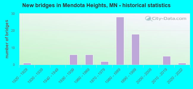
- New bridges - historical statistics
- 11920-1929
- 61950-1959
- 61960-1969
- 21970-1979
- 281980-1989
- 181990-1999
- 52010-2019
- 12020-2022
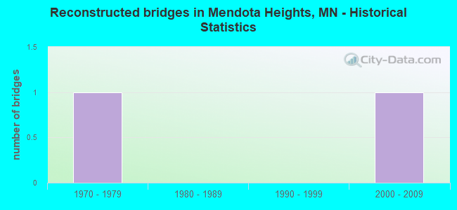
- Reconstructed bridges - Historical Statistics
- 11970-1979
- 01980-1989
- 01990-1999
- 12000-2009
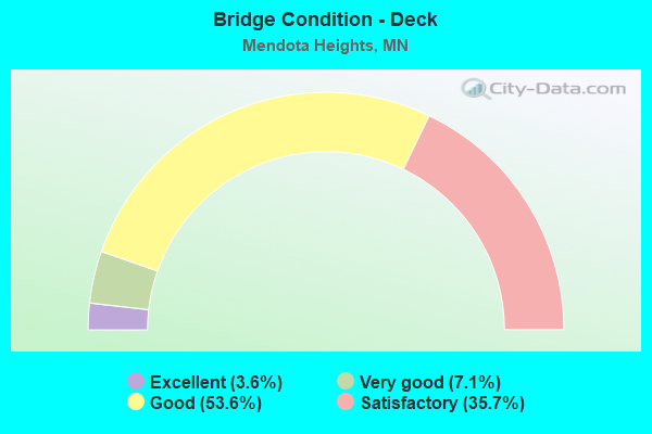
- Bridge Condition - Deck
- 3.6%Excellent
- 7.1%Very good
- 53.6%Good
- 35.7%Satisfactory
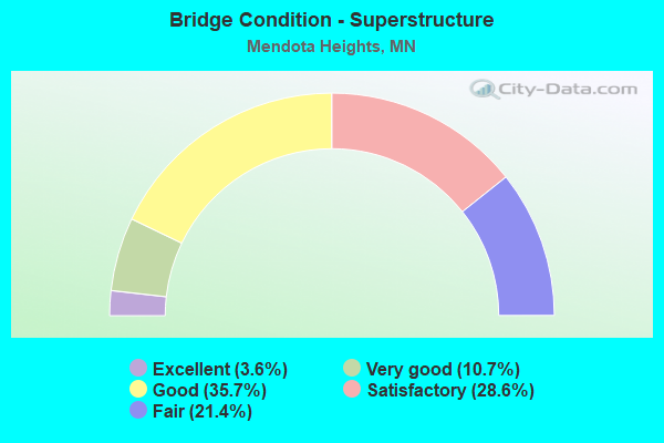
- Bridge Condition - Superstructure
- 3.6%Excellent
- 10.7%Very good
- 35.7%Good
- 28.6%Satisfactory
- 21.4%Fair
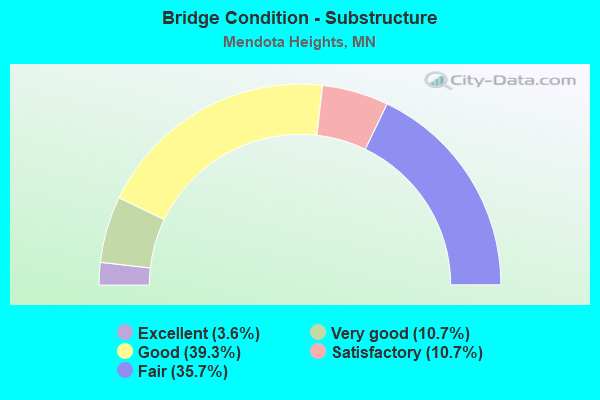
- Bridge Condition - Substructure
- 3.6%Excellent
- 10.7%Very good
- 39.3%Good
- 10.7%Satisfactory
- 35.7%Fair
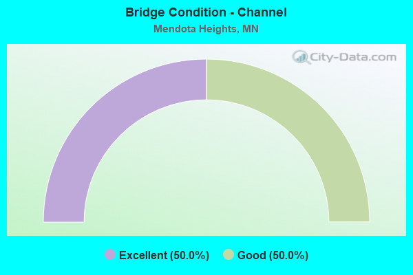
- Bridge Condition - Channel
- 50.0%Excellent
- 50.0%Good
Find on map >> Show street view
Structure Number: 9537, Location: 1.4 MI E OF JCT CR 145 (Lat: 46.446347, Lng: -92.352908), Route carried "on" structure: County highway 1333, Year Built: 2021, Status: Open, Structure Length: 2.27m (7.45ft), Average Daily Traffic: 25 (year 2021), Average Future Daily Traffic: 25 (year 2041), Design Load: HL 93, Features Intersected: LITTLE NET RIVER, Facility Carried by Structure: T 18
Minimum Vertical Clearance: 30+ m (98+ ft), Kilometerpoint: 0.000, Lanes on structure: 2, Owner: Town or Township Highway Agency, Approaching Roadway Width: 7.3m (24.0ft), Material/Design: Concrete continuous, Design/Construction: Slab, Number Of Spans In Main Unit: 3, Length of Maximum Span: 8.0m (26.2ft), Curb-To-Curb Width: 8.5m (27.9ft), Out-to-Out Width: 9.4m (30.8ft)
Condition: Deck: Excellent, Superstructure: Excellent, Substructure: Excellent, Channel: Excellent, Operating Rating: 60.6 metric tons, Method Used To Determine Operating Rating: Load and Resistance Factor Rating (LRFR) rating reported by rating factor(RF) method using HL-93 loadings, Inventory Rating: 46.7 metric tons, Method Used To Determine Inventory Rating: Load and Resistance Factor Rating (LRFR) rating reported by rating factor(RF) method using HL-93 loadings, Structural Evaluation: Superior to present desirable criteria, Deck Geometry: Better than present minimum criteria, Waterway Adequacy: Superior to present desirable criteria, Approach Roadway Alignment: Somewhat better than minimum adequacy, Designated Inspection Frequency: Every 6 months, Inspection Date: December 2021, Deck Structure Type: Concrete Cast-file-Place, Wearing Surface/Protective System: Wearing Surface: Monolithic Concrete, Deck Protection: Epoxy Coated Reinforcing
Find on map >> Show street view
Structure Number: 19076, Location: 0.3 MI NE OF JCT TH 35E (Lat: 44.903683, Lng: -93.133850), Route carried "on" structure: State highway 13, Year Built: 1983, Status: Open, Structure Length: 12.90m (42.32ft), Average Daily Traffic: 9,700 (year 2019), Truck Traffic: 3%, Average Future Daily Traffic: 9,300 (year 2039), Design Load: HS 20, Features Intersected: LiIydale Road
Minimum Vertical Clearance: 30+ m (98+ ft), Kilometerpoint: 0.000, Lanes on structure: 2, Lanes under structure: 2, Owner: State Highway Agency, Approaching Roadway Width: 13.4m (44.0ft), Material/Design: Prestressed concrete, Design/Construction: Stringer/Multi-beam, Number Of Spans In Main Unit: 4, Length of Maximum Span: 35.4m (116.1ft), Curb or Sidewalk Widths: Left: 1.8m (5.9ft), Right: 0.0m, Curb-To-Curb Width: 13.8m (45.3ft), Out-to-Out Width: 16.6m (54.5ft)
Condition: Deck: Good, Superstructure: Good, Substructure: Good, Operating Rating: 79.6 metric tons, Method Used To Determine Operating Rating: Load Factor (LF), Inventory Rating: 31.4 metric tons, Method Used To Determine Inventory Rating: Load Factor (LF), Structural Evaluation: Better than present minimum criteria, Deck Geometry: Superior to present desirable criteria, Underclear: Superior to present desirable criteria, Approach Roadway Alignment: Equal to present desirable criteria, Designated Inspection Frequency: Every 24 months, Inspection Date: August 2020, Deck Structure Type: Concrete Cast-file-Place, Wearing Surface/Protective System: Wearing Surface: Low Slump Concrete, Deck Protection: Epoxy Coated Reinforcing
Find on map >> Show street view
Structure Number: 19077, Location: 1.0 MI NE OF JCT TH 35E (Lat: 44.910356, Lng: -93.123811), Route carried "on" structure: State highway 13, Year Built: 1979, Status: Open, Structure Length: 10.49m (34.42ft), Average Daily Traffic: 6,900 (year 2019), Truck Traffic: 3%, Average Future Daily Traffic: 6,300 (year 2039), Design Load: HS 20, Features Intersected: HAPPY HOLLOW
Minimum Vertical Clearance: 30+ m (98+ ft), Kilometerpoint: 0.000, Lanes on structure: 2, Owner: State Highway Agency, Approaching Roadway Width: 8.5m (27.9ft), Material/Design: Steel continuous, Design/Construction: Frame, Number Of Spans In Main Unit: 3, Length of Maximum Span: 45.7m (149.9ft), Curb or Sidewalk Widths: Left: 2.4m (7.9ft), Right: 0.0m, Curb-To-Curb Width: 13.2m (43.3ft), Out-to-Out Width: 16.6m (54.5ft)
Condition: Deck: Good, Superstructure: Good, Substructure: Good, Channel: Good, Operating Rating: 98.0 metric tons, Method Used To Determine Operating Rating: Load Factor (LF), Inventory Rating: 58.8 metric tons, Method Used To Determine Inventory Rating: Load Factor (LF), Structural Evaluation: Better than present minimum criteria, Deck Geometry: Somewhat better than minimum adequacy, Waterway Adequacy: Superior to present desirable criteria, Approach Roadway Alignment: Equal to present desirable criteria, Designated Inspection Frequency: Every 24 months, Inspection Date: August 2020, Deck Structure Type: Concrete Cast-file-Place, Wearing Surface/Protective System: Wearing Surface: Low Slump Concrete, Deck Protection: Epoxy Coated Reinforcing
Find on map >> Show street view
Structure Number: 19088, Location: AT THE N JCT TH 13 (Lat: 44.883072, Lng: -93.170097), Route carried "on" structure: State highway 62, Year Built: 1993, Status: Open, Structure Length: 4.44m (14.57ft), Average Daily Traffic: 28,000 (year 2019), Truck Traffic: 5%, Average Future Daily Traffic: 27,500 (year 2039), Design Load: HS 25 or greater, Features Intersected: SIBLEY MEMORIAL; BIKE
Minimum Vertical Clearance: 30+ m (98+ ft), Kilometerpoint: 0.000, Lanes on structure: 3, Lanes under structure: 2, Base Highway Network: Yes, Owner: State Highway Agency, Approaching Roadway Width: 17.1m (56.1ft), Skew: 1 degrees, Material/Design: Steel continuous, Design/Construction: Stringer/Multi-beam, Number Of Spans In Main Unit: 2, Length of Maximum Span: 22.2m (72.8ft), Curb-To-Curb Width: 17.9m (58.7ft), Out-to-Out Width: 18.9m (62.0ft)
Condition: Deck: Good, Superstructure: Good, Substructure: Good, Operating Rating: 87.2 metric tons, Method Used To Determine Operating Rating: Load Factor (LF), Inventory Rating: 52.1 metric tons, Method Used To Determine Inventory Rating: Load Factor (LF), Structural Evaluation: Better than present minimum criteria, Deck Geometry: Better than present minimum criteria, Underclear: Superior to present desirable criteria, Approach Roadway Alignment: Equal to present desirable criteria, Designated Inspection Frequency: Every 24 months, Inspection Date: July 2020, Deck Structure Type: Concrete Cast-file-Place, Wearing Surface/Protective System: Wearing Surface: Low Slump Concrete, Deck Protection: Epoxy Coated Reinforcing
Find on map >> Show street view
Structure Number: 19089, Location: AT THE JCT TH 110 (Lat: 44.882358, Lng: -93.165206), Route carried "on" structure: State highway 55, Year Built: 1993, Status: Open, Structure Length: 9.81m (32.19ft), Average Daily Traffic: 15,750 (year 2017), Truck Traffic: 7%, Average Future Daily Traffic: 15,750 (year 2039), Design Load: HS 25 or greater, Features Intersected: MN 62 (OLD 110)
Minimum Vertical Clearance: 30+ m (98+ ft), Kilometerpoint: 0.000, Lanes on structure: 1, Lanes under structure: 2, Base Highway Network: Yes, Owner: State Highway Agency, Approaching Roadway Width: 7.3m (24.0ft), Skew: 5 degrees, Material/Design: Steel continuous, Design/Construction: Stringer/Multi-beam, Number Of Spans In Main Unit: 3, Length of Maximum Span: 43.9m (144.0ft), Curb-To-Curb Width: 7.9m (25.9ft), Out-to-Out Width: 8.9m (29.2ft)
Condition: Deck: Good, Superstructure: Good, Substructure: Good, Operating Rating: 93.1 metric tons, Method Used To Determine Operating Rating: Load Factor (LF), Inventory Rating: 55.5 metric tons, Method Used To Determine Inventory Rating: Load Factor (LF), Structural Evaluation: Better than present minimum criteria, Deck Geometry: High priority of corrective action, Underclear: Better than present minimum criteria, Approach Roadway Alignment: Better than present minimum criteria, Designated Inspection Frequency: Every 24 months, Inspection Date: July 2020, Deck Structure Type: Concrete Cast-file-Place, Wearing Surface/Protective System: Wearing Surface: Low Slump Concrete, Deck Protection: Epoxy Coated Reinforcing
Find on map >> Show street view
Structure Number: 1909, Location: 0.3 MI E OF JCT TH 110 (Lat: 44.878169, Lng: -93.163444), Route carried "on" structure: City street 113, Year Built: 1993, Status: Open, Structure Length: 6.43m (21.10ft), Average Daily Traffic: 1,050 (year 2014), Average Future Daily Traffic: 1,050 (year 2039), Design Load: HS 25 or greater, Features Intersected: TH 55
Minimum Vertical Clearance: 30+ m (98+ ft), Kilometerpoint: 0.000, Lanes on structure: 2, Lanes under structure: 4, Owner: State Highway Agency, Approaching Roadway Width: 13.4m (44.0ft), Material/Design: Prestressed concrete, Design/Construction: Stringer/Multi-beam, Number Of Spans In Main Unit: 2, Length of Maximum Span: 36.7m (120.4ft), Curb or Sidewalk Widths: Left: 2.4m (7.9ft), Right: 0.0m, Curb-To-Curb Width: 13.4m (44.0ft), Out-to-Out Width: 17.2m (56.4ft)
Condition: Deck: Good, Superstructure: Good, Substructure: Satisfactory, Operating Rating: 59.4 metric tons, Method Used To Determine Operating Rating: Load Factor (LF), Inventory Rating: 35.6 metric tons, Method Used To Determine Inventory Rating: Load Factor (LF), Structural Evaluation: Equal to present minimum criteria, Deck Geometry: Equal to present desirable criteria, Underclear: Equal to present minimum criteria, Approach Roadway Alignment: Equal to present desirable criteria, Designated Inspection Frequency: Every 24 months, Inspection Date: July 2020, Deck Structure Type: Concrete Cast-file-Place, Wearing Surface/Protective System: Wearing Surface: Low Slump Concrete, Deck Protection: Epoxy Coated Reinforcing
Find on map >> Show street view
Structure Number: 1982, Location: At the JCT TH 35E; 13 (Lat: 44.901342, Lng: -93.136056), Route carried "on" structure: State highway 13, Year Built: 1992, Status: Open, Structure Length: 6.70m (21.98ft), Average Daily Traffic: 9,700 (year 2019), Truck Traffic: 3%, Average Future Daily Traffic: 9,300 (year 2039), Design Load: HS 25 or greater, Features Intersected: 35E
Minimum Vertical Clearance: 30+ m (98+ ft), Kilometerpoint: 0.000, Lanes on structure: 4, Lanes under structure: 5, Owner: State Highway Agency, Approaching Roadway Width: 19.5m (64.0ft), Skew: 3 degrees, Material/Design: Prestressed concrete, Design/Construction: Stringer/Multi-beam, Number Of Spans In Main Unit: 2, Length of Maximum Span: 33.4m (109.6ft), Curb or Sidewalk Widths: Left: 1.8m (5.9ft), Right: 0.0m, Curb-To-Curb Width: 19.5m (64.0ft), Out-to-Out Width: 22.2m (72.8ft)
Condition: Deck: Good, Superstructure: Good, Substructure: Good, Operating Rating: 58.1 metric tons, Method Used To Determine Operating Rating: Load Factor (LF), Inventory Rating: 44.7 metric tons, Method Used To Determine Inventory Rating: Load Factor (LF), Structural Evaluation: Better than present minimum criteria, Deck Geometry: Better than present minimum criteria, Underclear: Somewhat better than minimum adequacy, Approach Roadway Alignment: Equal to present desirable criteria, Designated Inspection Frequency: Every 24 months, Inspection Date: September 2021, Deck Structure Type: Concrete Cast-file-Place, Wearing Surface/Protective System: Wearing Surface: Low Slump Concrete, Deck Protection: Epoxy Coated Reinforcing
Find on map >> Show street view
Structure Number: 19822, Location: 0.6 MI S OF JCT TH 110 (Lat: 44.874958, Lng: -93.143264), Route carried "on" structure: City street 106, Year Built: 1982, Status: Open, Structure Length: 8.29m (27.20ft), Average Daily Traffic: 770 (year 2014), Average Future Daily Traffic: 770 (year 2039), Design Load: HS 20, Features Intersected: I 35E
Minimum Vertical Clearance: 30+ m (98+ ft), Kilometerpoint: 0.000, Lanes on structure: 2, Lanes under structure: 6, Owner: State Highway Agency, Approaching Roadway Width: 7.3m (24.0ft), Skew: 1 degrees, Material/Design: Steel continuous, Design/Construction: Stringer/Multi-beam, Number Of Spans In Main Unit: 2, Length of Maximum Span: 43.6m (143.0ft), Curb or Sidewalk Widths: Left: 1.8m (5.9ft), Right: 2.4m (7.9ft), Curb-To-Curb Width: 12.2m (40.0ft), Out-to-Out Width: 17.2m (56.4ft)
Condition: Deck: Good, Superstructure: Satisfactory, Substructure: Fair, Operating Rating: 88.0 metric tons, Method Used To Determine Operating Rating: Load Factor (LF), Inventory Rating: 52.7 metric tons, Method Used To Determine Inventory Rating: Load Factor (LF), Structural Evaluation: Somewhat better than minimum adequacy, Deck Geometry: Equal to present desirable criteria, Underclear: Somewhat better than minimum adequacy, Approach Roadway Alignment: Equal to present desirable criteria, Designated Inspection Frequency: Every 24 months, Inspection Date: June 2020, Deck Structure Type: Concrete Cast-file-Place, Wearing Surface/Protective System: Wearing Surface: Low Slump Concrete, Deck Protection: Epoxy Coated Reinforcing
Find on map >> Show street view
Structure Number: 19823, Location: AT THE JCT TH 494; 35E (Lat: 44.862964, Lng: -93.145211), Route carried "on" structure: Interstate 494, Year Built: 1982, Status: Open, Structure Length: 12.59m (41.31ft), Average Daily Traffic: 47,000 (year 2019), Truck Traffic: 6%, Average Future Daily Traffic: 49,000 (year 2039), Design Load: HS 20, Features Intersected: I 35E
Minimum Vertical Clearance: 30+ m (98+ ft), Kilometerpoint: 0.000, Lanes on structure: 3, Lanes under structure: 8, Base Highway Network: Yes, Owner: State Highway Agency, Approaching Roadway Width: 17.1m (56.1ft), Material/Design: Steel continuous, Design/Construction: Stringer/Multi-beam, Number Of Spans In Main Unit: 4, Length of Maximum Span: 38.3m (125.7ft), Curb-To-Curb Width: 21.2m (69.6ft), Out-to-Out Width: 22.2m (72.8ft)
Condition: Deck: Satisfactory, Superstructure: Fair, Substructure: Fair, Operating Rating: 44.4 metric tons, Method Used To Determine Operating Rating: Load Factor (LF), Inventory Rating: 26.8 metric tons, Method Used To Determine Inventory Rating: Load Factor (LF), Structural Evaluation: Somewhat better than minimum adequacy, Deck Geometry: Superior to present desirable criteria, Underclear: Superior to present desirable criteria, Approach Roadway Alignment: Equal to present desirable criteria, Designated Inspection Frequency: Every 24 months, Inspection Date: November 2021, Deck Structure Type: Concrete Cast-file-Place, Wearing Surface/Protective System: Wearing Surface: Low Slump Concrete, Deck Protection: Epoxy Coated Reinforcing
Find on map >> Show street view
Structure Number: 19824, Location: AT THE JCT TH 494; 35E (Lat: 44.862683, Lng: -93.145211), Route carried "on" structure: Interstate 494, Year Built: 1982, Status: Open, Structure Length: 12.59m (41.31ft), Average Daily Traffic: 47,000 (year 2019), Truck Traffic: 6%, Average Future Daily Traffic: 49,000 (year 2039), Design Load: HS 20, Features Intersected: I 35E
Minimum Vertical Clearance: 30+ m (98+ ft), Kilometerpoint: 0.000, Lanes on structure: 4, Lanes under structure: 8, Base Highway Network: Yes, Owner: State Highway Agency, Approaching Roadway Width: 20.7m (67.9ft), Material/Design: Steel continuous, Design/Construction: Stringer/Multi-beam, Number Of Spans In Main Unit: 4, Length of Maximum Span: 38.3m (125.7ft), Curb-To-Curb Width: 21.6m (70.9ft), Out-to-Out Width: 22.6m (74.1ft)
Condition: Deck: Satisfactory, Superstructure: Fair, Substructure: Fair, Operating Rating: 50.2 metric tons, Method Used To Determine Operating Rating: Load Factor (LF), Inventory Rating: 30.0 metric tons, Method Used To Determine Inventory Rating: Load Factor (LF), Structural Evaluation: Somewhat better than minimum adequacy, Deck Geometry: Better than present minimum criteria, Underclear: Somewhat better than minimum adequacy, Approach Roadway Alignment: Equal to present desirable criteria, Designated Inspection Frequency: Every 24 months, Inspection Date: November 2021, Deck Structure Type: Concrete Cast-file-Place, Wearing Surface/Protective System: Wearing Surface: Low Slump Concrete, Deck Protection: Epoxy Coated Reinforcing
Find on map >> Show street view
Structure Number: 19851, Location: 0.5 MI N OF JCT TH110 (Lat: 44.890817, Lng: -93.131281), Route carried "on" structure: Interstate 35E, Year Built: 1966, Status: Open, Structure Length: 4.13m (13.55ft), Average Daily Traffic: 90,000 (year 2019), Truck Traffic: 2%, Average Future Daily Traffic: 88,000 (year 2039), Design Load: HS 20+Mod, Features Intersected: Marie Avenue
Minimum Vertical Clearance: 30+ m (98+ ft), Kilometerpoint: 0.000, Lanes on structure: 4, Lanes under structure: 2, Base Highway Network: Yes, Owner: State Highway Agency, Approaching Roadway Width: 26.2m (86.0ft), Skew: 30 degrees, Material/Design: Steel continuous, Design/Construction: Stringer/Multi-beam, Number Of Spans In Main Unit: 3, Length of Maximum Span: 17.9m (58.7ft), Curb-To-Curb Width: 26.0m (85.3ft), Out-to-Out Width: 27.9m (91.5ft)
Condition: Deck: Satisfactory, Superstructure: Satisfactory, Substructure: Satisfactory, Operating Rating: 57.4 metric tons, Method Used To Determine Operating Rating: Load Factor (LF), Inventory Rating: 34.5 metric tons, Method Used To Determine Inventory Rating: Load Factor (LF), Structural Evaluation: Equal to present minimum criteria, Deck Geometry: Superior to present desirable criteria, Underclear: Equal to present minimum criteria, Approach Roadway Alignment: Equal to present desirable criteria, Designated Inspection Frequency: Every 24 months, Inspection Date: June 2020, Deck Structure Type: Concrete Cast-file-Place, Wearing Surface/Protective System: Wearing Surface: Low Slump Concrete, Deck Protection: Epoxy Coated Reinforcing
Find on map >> Show street view
Structure Number: 19857, Location: 0.8 MI E OF JCT TH 35E (Lat: 44.862703, Lng: -93.129556), Route carried "on" structure: State highway 149, Year Built: 1984, Status: Open, Structure Length: 9.57m (31.40ft), Average Daily Traffic: 23,248 (year 2019), Truck Traffic: 3%, Average Future Daily Traffic: 22,900 (year 2039), Design Load: HS 20, Features Intersected: I 494
Minimum Vertical Clearance: 30+ m (98+ ft), Kilometerpoint: 0.000, Lanes on structure: 4, Lanes under structure: 8, Owner: State Highway Agency, Approaching Roadway Width: 13.4m (44.0ft), Skew: 21 degrees, Material/Design: Steel continuous, Design/Construction: Stringer/Multi-beam, Number Of Spans In Main Unit: 2, Length of Maximum Span: 47.2m (154.9ft), Curb or Sidewalk Widths: Left: 1.8m (5.9ft), Right: 0.0m, Curb-To-Curb Width: 22.8m (74.8ft), Out-to-Out Width: 31.3m (102.7ft)
Condition: Deck: Satisfactory, Superstructure: Fair, Substructure: Fair, Operating Rating: 74.5 metric tons, Method Used To Determine Operating Rating: Load Factor (LF), Inventory Rating: 44.5 metric tons, Method Used To Determine Inventory Rating: Load Factor (LF), Structural Evaluation: Somewhat better than minimum adequacy, Deck Geometry: Superior to present desirable criteria, Underclear: Somewhat better than minimum adequacy, Approach Roadway Alignment: Equal to present desirable criteria, Designated Inspection Frequency: Every 24 months, Inspection Date: November 2021, Deck Structure Type: Concrete Cast-file-Place, Wearing Surface/Protective System: Wearing Surface: Low Slump Concrete, Deck Protection: Epoxy Coated Reinforcing
Find on map >> Show street view
Structure Number: 19861, Location: 0.2 MI N OF JCT TH 494 (Lat: 44.865547, Lng: -93.144906), Route carried "on" structure: City street 103, Year Built: 1982, Status: Open, Structure Length: 20.80m (68.24ft), Average Daily Traffic: 3,650 (year 2014), Average Future Daily Traffic: 3,650 (year 2039), Design Load: HS 20, Features Intersected: I 35E, COLL, RAMPS
Minimum Vertical Clearance: 30+ m (98+ ft), Kilometerpoint: 0.000, Lanes on structure: 2, Lanes under structure: 12, Owner: State Highway Agency, Approaching Roadway Width: 15.9m (52.2ft), Material/Design: Steel continuous, Design/Construction: Stringer/Multi-beam, Number Of Spans In Main Unit: 5, Length of Maximum Span: 49.5m (162.4ft), Curb or Sidewalk Widths: Left: 1.8m (5.9ft), Right: 0.0m, Curb-To-Curb Width: 16.3m (53.5ft), Out-to-Out Width: 19.0m (62.3ft)
Condition: Deck: Satisfactory, Superstructure: Good, Substructure: Fair, Operating Rating: 52.2 metric tons, Method Used To Determine Operating Rating: Load Factor (LF), Inventory Rating: 31.4 metric tons, Method Used To Determine Inventory Rating: Load Factor (LF), Structural Evaluation: Somewhat better than minimum adequacy, Deck Geometry: Superior to present desirable criteria, Underclear: Superior to present desirable criteria, Approach Roadway Alignment: Equal to present desirable criteria, Designated Inspection Frequency: Every 24 months, Inspection Date: June 2020, Deck Structure Type: Concrete Cast-file-Place, Wearing Surface/Protective System: Wearing Surface: Low Slump Concrete, Deck Protection: Epoxy Coated Reinforcing
Find on map >> Show street view
Structure Number: 19897, Location: AT THE JCT TH 35E; 494 (Lat: 44.862678, Lng: -93.148189), Route carried "on" structure: Interstate 494, Year Built: 1983, Status: Open, Structure Length: 4.89m (16.04ft), Average Daily Traffic: 47,000 (year 2019), Truck Traffic: 6%, Average Future Daily Traffic: 49,000 (year 2039), Design Load: HS 20+Mod, Features Intersected: WB OFF RAMP TO I 35E
Minimum Vertical Clearance: 30+ m (98+ ft), Kilometerpoint: 0.000, Lanes on structure: 3, Lanes under structure: 2, Base Highway Network: Yes, Owner: State Highway Agency, Approaching Roadway Width: 17.1m (56.1ft), Skew: 2 degrees, Material/Design: Steel continuous, Design/Construction: Stringer/Multi-beam, Number Of Spans In Main Unit: 3, Length of Maximum Span: 19.5m (64.0ft), Curb-To-Curb Width: 18.4m (60.4ft), Out-to-Out Width: 19.4m (63.6ft)
Condition: Deck: Satisfactory, Superstructure: Satisfactory, Substructure: Satisfactory, Operating Rating: 73.5 metric tons, Method Used To Determine Operating Rating: Load Factor (LF), Inventory Rating: 44.1 metric tons, Method Used To Determine Inventory Rating: Load Factor (LF), Structural Evaluation: Equal to present minimum criteria, Deck Geometry: Equal to present desirable criteria, Underclear: Equal to present desirable criteria, Approach Roadway Alignment: Equal to present desirable criteria, Length Of Structure Improvement: 1.65m (5.41ft), Designated Inspection Frequency: Every 24 months, Inspection Date: November 2021, Bridge Improvement Cost: $999,999,000, Deck Structure Type: Concrete Cast-file-Place, Wearing Surface/Protective System: Wearing Surface: Low Slump Concrete, Deck Protection: Epoxy Coated Reinforcing
Find on map >> Show street view
Structure Number: 19898, Location: AT THE JCT TH 35E; 494 (Lat: 44.862317, Lng: -93.148169), Route carried "on" structure: Interstate 494, Year Built: 1983, Status: Open, Structure Length: 4.75m (15.58ft), Average Daily Traffic: 47,000 (year 2019), Truck Traffic: 7%, Average Future Daily Traffic: 49,000 (year 2039), Design Load: HS 20+Mod, Features Intersected: OFF RAMP TO I 35E SB
Minimum Vertical Clearance: 30+ m (98+ ft), Kilometerpoint: 0.000, Lanes on structure: 4, Lanes under structure: 2, Base Highway Network: Yes, Owner: State Highway Agency, Approaching Roadway Width: 20.7m (67.9ft), Skew: 2 degrees, Material/Design: Steel continuous, Design/Construction: Stringer/Multi-beam, Number Of Spans In Main Unit: 3, Length of Maximum Span: 18.9m (62.0ft), Curb-To-Curb Width: 21.6m (70.9ft), Out-to-Out Width: 22.9m (75.1ft)
Condition: Deck: Good, Superstructure: Satisfactory, Substructure: Good, Operating Rating: 99.6 metric tons, Method Used To Determine Operating Rating: Load Factor (LF), Inventory Rating: 62.0 metric tons, Method Used To Determine Inventory Rating: Load Factor (LF), Structural Evaluation: Equal to present minimum criteria, Deck Geometry: Better than present minimum criteria, Underclear: Equal to present desirable criteria, Approach Roadway Alignment: Equal to present desirable criteria, Length Of Structure Improvement: 1.59m (5.22ft), Designated Inspection Frequency: Every 24 months, Inspection Date: November 2021, Bridge Improvement Cost: $999,999,000, Total Project Cost: $827,000,000, Deck Structure Type: Concrete Cast-file-Place, Wearing Surface/Protective System: Wearing Surface: Low Slump Concrete, Deck Protection: Epoxy Coated Reinforcing
Find on map >> Show street view
Structure Number: 19899, Location: AT THE JCT TH 494; 35E (Lat: 44.864589, Lng: -93.144975), Route carried "on" structure: Ramp Interstate 617, Year Built: 1983, Status: Open, Structure Length: 12.24m (40.16ft), Average Daily Traffic: 4,000 (year 1996), Average Future Daily Traffic: 4,000 (year 2029), Design Load: HS 20+Mod, Features Intersected: I 494/I 35E NORTH RAMP
Minimum Vertical Clearance: 30+ m (98+ ft), Kilometerpoint: 0.000, Lanes on structure: 2, Lanes under structure: 8, Base Highway Network: Yes, Owner: State Highway Agency, Approaching Roadway Width: 9.1m (29.9ft), Material/Design: Steel continuous, Design/Construction: Stringer/Multi-beam, Number Of Spans In Main Unit: 4, Length of Maximum Span: 37.0m (121.4ft), Curb-To-Curb Width: 10.0m (32.8ft), Out-to-Out Width: 11.0m (36.1ft)
Condition: Deck: Satisfactory, Superstructure: Satisfactory, Substructure: Fair, Operating Rating: 73.5 metric tons, Method Used To Determine Operating Rating: Load Factor (LF), Inventory Rating: 44.1 metric tons, Method Used To Determine Inventory Rating: Load Factor (LF), Structural Evaluation: Somewhat better than minimum adequacy, Deck Geometry: Equal to present minimum criteria, Underclear: Somewhat better than minimum adequacy, Approach Roadway Alignment: Equal to present minimum criteria, Designated Inspection Frequency: Every 24 months, Inspection Date: December 2021, Deck Structure Type: Concrete Cast-file-Place, Wearing Surface/Protective System: Wearing Surface: Low Slump Concrete, Deck Protection: Epoxy Coated Reinforcing
Find on map >> Show street view
Structure Number: 199, Location: AT THE JCT TH 35E; 494 (Lat: 44.862056, Lng: -93.148231), Route carried "on" structure: Ramp Interstate 5465, Year Built: 1983, Status: Open, Structure Length: 4.47m (14.67ft), Average Daily Traffic: 6,000 (year 1996), Average Future Daily Traffic: 6,000 (year 2029), Design Load: HS 20+Mod, Features Intersected: OFF RAMP TO 35E SB
Minimum Vertical Clearance: 30+ m (98+ ft), Kilometerpoint: 0.000, Lanes on structure: 2, Lanes under structure: 2, Base Highway Network: Yes, Owner: State Highway Agency, Approaching Roadway Width: 9.1m (29.9ft), Skew: 1 degrees, Material/Design: Steel continuous, Design/Construction: Stringer/Multi-beam, Number Of Spans In Main Unit: 3, Length of Maximum Span: 18.3m (60.0ft), Curb-To-Curb Width: 10.4m (34.1ft), Out-to-Out Width: 11.4m (37.4ft)
Condition: Deck: Satisfactory, Superstructure: Satisfactory, Substructure: Good, Operating Rating: 72.5 metric tons, Method Used To Determine Operating Rating: Load Factor (LF), Inventory Rating: 43.4 metric tons, Method Used To Determine Inventory Rating: Load Factor (LF), Structural Evaluation: Equal to present minimum criteria, Deck Geometry: Better than present minimum criteria, Underclear: Equal to present desirable criteria, Approach Roadway Alignment: Equal to present desirable criteria, Length Of Structure Improvement: 1.65m (5.41ft), Designated Inspection Frequency: Every 24 months, Inspection Date: November 2021, Bridge Improvement Cost: $654,000,000, Deck Structure Type: Concrete Cast-file-Place, Wearing Surface/Protective System: Wearing Surface: Low Slump Concrete, Deck Protection: Epoxy Coated Reinforcing
Find on map >> Show street view
Structure Number: 27107, Location: 0.1 MI SW OF JCT TH 55 (Lat: 44.889619, Lng: -93.186206), Route carried "on" structure: Ramp State highway 611, Year Built: 1992, Status: Open, Structure Length: 9.28m (30.45ft), Average Daily Traffic: 9,000 (year 1996), Truck Traffic: 6%, Average Future Daily Traffic: 9,000 (year 2029), Design Load: HS 25 or greater, Features Intersected: TH 55
Minimum Vertical Clearance: 30+ m (98+ ft), Kilometerpoint: 0.000, Lanes on structure: 2, Lanes under structure: 5, Base Highway Network: Yes, Owner: State Highway Agency, Approaching Roadway Width: 11.6m (38.1ft), Skew: 3 degrees, Material/Design: Steel continuous, Design/Construction: Stringer/Multi-beam, Number Of Spans In Main Unit: 2, Length of Maximum Span: 49.1m (161.1ft), Curb-To-Curb Width: 12.4m (40.7ft), Out-to-Out Width: 13.4m (44.0ft)
Condition: Deck: Good, Superstructure: Good, Substructure: Good, Operating Rating: 75.1 metric tons, Method Used To Determine Operating Rating: Load Factor (LF), Inventory Rating: 44.1 metric tons, Method Used To Determine Inventory Rating: Load Factor (LF), Structural Evaluation: Better than present minimum criteria, Deck Geometry: Superior to present desirable criteria, Underclear: High priority of corrective action, Approach Roadway Alignment: Equal to present desirable criteria, Designated Inspection Frequency: Every 24 months, Inspection Date: September 2021, Deck Structure Type: Concrete Cast-file-Place, Wearing Surface/Protective System: Wearing Surface: Low Slump Concrete, Deck Protection: Epoxy Coated Reinforcing
Find on map >> Show street view
Structure Number: 27269, Location: 0.016 MI W JCT MN 5; RPS (Lat: 44.877514, Lng: -93.194633), Route carried "on" structure: Ramp State highway 1065, Year Built: 1999, Status: Open, Structure Length: 26.20m (85.96ft), Average Daily Traffic: 1 (year 2009), Average Future Daily Traffic: 1 (year 2029), Design Load: HS 25 or greater, Features Intersected: MSP EXIT RAMPS TO MN 5
Minimum Vertical Clearance: 30+ m (98+ ft), Kilometerpoint: 0.000, Lanes on structure: 1, Lanes under structure: 4, Base Highway Network: Yes, Owner: Private, Approaching Roadway Width: 6.1m (20.0ft), Material/Design: Steel continuous, Design/Construction: Stringer/Multi-beam, Number Of Spans In Main Unit: 8, Length of Maximum Span: 36.6m (120.1ft), Curb-To-Curb Width: 6.1m (20.0ft), Out-to-Out Width: 7.1m (23.3ft)
Condition: Deck: Good, Superstructure: Good, Substructure: Good, Operating Rating: 88.5 metric tons, Method Used To Determine Operating Rating: Load Factor (LF), Inventory Rating: 52.9 metric tons, Method Used To Determine Inventory Rating: Load Factor (LF), Structural Evaluation: Better than present minimum criteria, Deck Geometry: Somewhat better than minimum adequacy, Underclear: Superior to present desirable criteria, Approach Roadway Alignment: Meets minimum limits, Designated Inspection Frequency: Every 24 months, Inspection Date: December 2020, Deck Structure Type: Concrete Cast-file-Place, Wearing Surface/Protective System: Wearing Surface: Monolithic Concrete, Deck Protection: Epoxy Coated Reinforcing
Find on map >> Show street view
Structure Number: 9153, Location: 1.0 MI SW OF JCT TH 55 (Lat: 44.877728, Lng: -93.194053), Route carried "on" structure: State highway 5, Year Built: 1959, Status: Open, Structure Length: 6.35m (20.83ft), Average Daily Traffic: 32,500 (year 2017), Truck Traffic: 3%, Average Future Daily Traffic: 32,500 (year 2039), Design Load: HS 20, Features Intersected: Inbnd Outbnd Airport Rd
Minimum Vertical Clearance: 30+ m (98+ ft), Kilometerpoint: 0.000, Lanes on structure: 2, Lanes under structure: 2, Base Highway Network: Yes, Owner: State Highway Agency, Approaching Roadway Width: 9.1m (29.9ft), Material/Design: Prestressed concrete, Design/Construction: Stringer/Multi-beam, Number Of Spans In Main Unit: 3, Length of Maximum Span: 21.2m (69.6ft), Curb-To-Curb Width: 10.8m (35.4ft), Out-to-Out Width: 11.8m (38.7ft)
Condition: Deck: Good, Superstructure: Very good, Substructure: Very good, Operating Rating: 53.9 metric tons, Method Used To Determine Operating Rating: Load Factor (LF), Inventory Rating: 15.7 metric tons, Method Used To Determine Inventory Rating: Load Factor (LF), Structural Evaluation: High priority of corrective action, Deck Geometry: Meets minimum limits, Underclear: Equal to present minimum criteria, Approach Roadway Alignment: Equal to present desirable criteria, Length Of Structure Improvement: 2.16m (7.09ft), Designated Inspection Frequency: Every 12 months, Inspection Date: July 2021, Bridge Improvement Cost: $999,999,000, Deck Structure Type: Concrete Cast-file-Place, Wearing Surface/Protective System: Wearing Surface: Low Slump Concrete, Deck Protection: Epoxy Coated Reinforcing
Find on map >> Show street view
Structure Number: 9154, Location: 1.0 MI SW OF JCT TH 55 (Lat: 44.877842, Lng: -93.194236), Route carried "on" structure: Ramp State highway 682, Year Built: 1959, Status: Open, Structure Length: 4.09m (13.42ft), Average Daily Traffic: 15,500 (year 1994), Truck Traffic: 2%, Average Future Daily Traffic: 15,500 (year 2029), Design Load: H 20, Features Intersected: OUTBND AIRPORT RD
Minimum Vertical Clearance: 5.06m (16.60ft), Kilometerpoint: 0.000, Lanes on structure: 2, Lanes under structure: 2, Base Highway Network: Yes, Owner: State Highway Agency, Approaching Roadway Width: 11.0m (36.1ft), Skew: 2 degrees, Material/Design: Prestressed concrete, Design/Construction: Stringer/Multi-beam, Number Of Spans In Main Unit: 3, Length of Maximum Span: 16.1m (52.8ft), Curb-To-Curb Width: 10.5m (34.4ft), Out-to-Out Width: 11.5m (37.7ft)
Condition: Deck: Good, Superstructure: Satisfactory, Substructure: Good, Operating Rating: 46.0 metric tons, Method Used To Determine Operating Rating: Load and Resistance Factor Rating (LRFR) rating reported by rating factor(RF) method using HL-93 loadings, Inventory Rating: 26.9 metric tons, Method Used To Determine Inventory Rating: Load and Resistance Factor Rating (LRFR) rating reported by rating factor(RF) method using HL-93 loadings, Structural Evaluation: Equal to present minimum criteria, Deck Geometry: Equal to present minimum criteria, Underclear: Meets minimum limits, Approach Roadway Alignment: Better than present minimum criteria, Length Of Structure Improvement: 1.49m (4.89ft), Designated Inspection Frequency: Every 24 months, Inspection Date: October 2021, Bridge Improvement Cost: $603,000,000, Deck Structure Type: Concrete Cast-file-Place, Wearing Surface/Protective System: Wearing Surface: Low Slump Concrete, Deck Protection: Epoxy Coated Reinforcing
Find on map >> Show street view
Structure Number: 9409, Location: 1.6 MI SW OF JCT TH 55 (Lat: 44.870364, Lng: -93.198494), Route carried "on" structure: Other road 4, Year Built: 1959, Status: Open, Structure Length: 6.97m (22.87ft), Average Daily Traffic: 4,900 (year 2015), Average Future Daily Traffic: 4,900 (year 2039), Design Load: HS 20, Features Intersected: TH 5
Minimum Vertical Clearance: 30+ m (98+ ft), Kilometerpoint: 0.000, Lanes on structure: 2, Lanes under structure: 6, Owner: State Highway Agency, Approaching Roadway Width: 11.0m (36.1ft), Material/Design: Prestressed concrete, Design/Construction: Stringer/Multi-beam, Number Of Spans In Main Unit: 4, Length of Maximum Span: 24.2m (79.4ft), Curb-To-Curb Width: 11.0m (36.1ft), Out-to-Out Width: 12.0m (39.4ft)
Condition: Deck: Satisfactory, Superstructure: Fair, Substructure: Fair, Operating Rating: 88.0 metric tons, Method Used To Determine Operating Rating: Load Factor (LF), Inventory Rating: 34.6 metric tons, Method Used To Determine Inventory Rating: Load Factor (LF), Structural Evaluation: Somewhat better than minimum adequacy, Deck Geometry: Somewhat better than minimum adequacy, Underclear: Meets minimum limits, Approach Roadway Alignment: Better than present minimum criteria, Length Of Structure Improvement: 2.35m (7.71ft), Designated Inspection Frequency: Every 24 months, Inspection Date: October 2021, Bridge Improvement Cost: $826,000,000, Total Project Cost: $999,999,000, Deck Structure Type: Concrete Cast-file-Place, Wearing Surface/Protective System: Wearing Surface: Low Slump Concrete, Deck Protection: Epoxy Coated Reinforcing
Find on map >> Show street view
Structure Number: 9537, Location: AT THE JCT OF TH 110 (Lat: 44.883864, Lng: -93.138525), Route carried "on" structure: State highway 62, Year Built: 1966, Year Reconstructed: 1979, Status: Open, Structure Length: 6.27m (20.57ft), Average Daily Traffic: 46,000 (year 2019), Truck Traffic: 4%, Average Future Daily Traffic: 16,750 (year 2039), Design Load: HS 20, Features Intersected: I 35E
Minimum Vertical Clearance: 30+ m (98+ ft), Kilometerpoint: 0.000, Lanes on structure: 2, Lanes under structure: 5, Base Highway Network: Yes, Owner: State Highway Agency, Approaching Roadway Width: 11.0m (36.1ft), Skew: 3 degrees, Material/Design: Steel continuous, Design/Construction: Stringer/Multi-beam, Number Of Spans In Main Unit: 2, Length of Maximum Span: 31.8m (104.3ft), Curb-To-Curb Width: 12.0m (39.4ft), Out-to-Out Width: 13.0m (42.7ft)
Condition: Deck: Good, Superstructure: Fair, Substructure: Fair, Operating Rating: 56.5 metric tons, Method Used To Determine Operating Rating: Load Factor (LF), Inventory Rating: 33.9 metric tons, Method Used To Determine Inventory Rating: Load Factor (LF), Structural Evaluation: Somewhat better than minimum adequacy, Deck Geometry: Better than present minimum criteria, Underclear: Meets minimum limits, Approach Roadway Alignment: Equal to present desirable criteria, Designated Inspection Frequency: Every 24 months, Inspection Date: September 2021, Deck Structure Type: Concrete Cast-file-Place, Wearing Surface/Protective System: Wearing Surface: Low Slump Concrete, Deck Protection: Epoxy Coated Reinforcing
Find on map >> Show street view
Structure Number: 9538, Location: AT THE JCT OF TH 110; 35E (Lat: 44.883667, Lng: -93.138656), Route carried "on" structure: State highway 62, Year Built: 1966, Year Reconstructed: 2011, Status: Open, Structure Length: 6.25m (20.51ft), Average Daily Traffic: 17,000 (year 2019), Truck Traffic: 2%, Average Future Daily Traffic: 16,750 (year 2039), Design Load: HS 20, Features Intersected: I 35E
Minimum Vertical Clearance: 30+ m (98+ ft), Kilometerpoint: 0.000, Lanes on structure: 3, Lanes under structure: 5, Base Highway Network: Yes, Owner: State Highway Agency, Approaching Roadway Width: 11.3m (37.1ft), Skew: 4 degrees, Material/Design: Steel continuous, Design/Construction: Stringer/Multi-beam, Number Of Spans In Main Unit: 2, Length of Maximum Span: 30.9m (101.4ft), Curb-To-Curb Width: 14.4m (47.2ft), Out-to-Out Width: 15.4m (50.5ft)
Condition: Deck: Satisfactory, Superstructure: Fair, Substructure: Fair, Operating Rating: 57.5 metric tons, Method Used To Determine Operating Rating: Load Factor (LF), Inventory Rating: 34.5 metric tons, Method Used To Determine Inventory Rating: Load Factor (LF), Structural Evaluation: Somewhat better than minimum adequacy, Deck Geometry: Somewhat better than minimum adequacy, Underclear: Meets minimum limits, Approach Roadway Alignment: Equal to present desirable criteria, Designated Inspection Frequency: Every 24 months, Inspection Date: September 2021, Deck Structure Type: Concrete Cast-file-Place, Wearing Surface/Protective System: Wearing Surface: Low Slump Concrete, Deck Protection: Epoxy Coated Reinforcing
Find on map >> Show street view
Structure Number: 9768, Location: Just North of Jct TH 55 (Lat: 44.883956, Lng: -93.168625), Route carried "on" structure: State highway 13, Year Built: 1993, Status: Open, Structure Length: 0.83m (2.72ft), Average Daily Traffic: 4,178 (year 2019), Truck Traffic: 2%, Average Future Daily Traffic: 4,200 (year 2039), Design Load: HS 25 or greater, Features Intersected: BIKEWAY
Minimum Vertical Clearance: 30+ m (98+ ft), Kilometerpoint: 0.000, Lanes on structure: 3, Owner: State Highway Agency, Approaching Roadway Width: 17.4m (57.1ft), Material/Design: Concrete, Design/Construction: Culvert, Number Of Spans In Main Unit: 1, Length of Maximum Span: 7.3m (24.0ft)
Condition: Culverts: Good, Operating Rating: 49.0 metric tons, Method Used To Determine Operating Rating: Assigned ratings based on Allowable Stress Design (ASD) reported in metric tons, Inventory Rating: 32.7 metric tons, Method Used To Determine Inventory Rating: Assigned ratings based on Allowable Stress Design (ASD) reported in metric tons, Structural Evaluation: Better than present minimum criteria, Approach Roadway Alignment: Equal to present desirable criteria, Designated Inspection Frequency: Every 48 months, Inspection Date: May 2019
Find on map >> Show street view
Structure Number: R0812, Location: 0.2 MI W OF JCT TH 149 (Lat: 44.890889, Lng: -93.124778), Route carried "on" structure: City street 101, Year Built: 1974, Status: Open, Structure Length: 12.83m (42.09ft), Average Daily Traffic: 3,300 (year 2014), Average Future Daily Traffic: 3,300 (year 2039), Design Load: HS 20, Features Intersected: UNSTABLE SOIL
Minimum Vertical Clearance: 30+ m (98+ ft), Kilometerpoint: 0.000, Lanes on structure: 2, Owner: City or Municipal Highway Agency, Approaching Roadway Width: 13.4m (44.0ft), Material/Design: Concrete continuous, Design/Construction: Slab, Number Of Spans In Main Unit: 28, Length of Maximum Span: 4.6m (15.1ft), Curb-To-Curb Width: 13.4m (44.0ft), Out-to-Out Width: 13.8m (45.3ft)
Condition: Deck: Good, Superstructure: Good, Substructure: Good, Operating Rating: 26.9 metric tons, Method Used To Determine Operating Rating: Load and Resistance Factor Rating (LRFR) rating reported by rating factor(RF) method using HL-93 loadings, Inventory Rating: 20.7 metric tons, Method Used To Determine Inventory Rating: Load and Resistance Factor Rating (LRFR) rating reported by rating factor(RF) method using HL-93 loadings, Structural Evaluation: Somewhat better than minimum adequacy, Deck Geometry: Better than present minimum criteria, Approach Roadway Alignment: Equal to present desirable criteria, Designated Inspection Frequency: Every 24 months, Inspection Date: September 2020, Deck Structure Type: Concrete Cast-file-Place, Wearing Surface/Protective System: Wearing Surface: Low Slump Concrete, Deck Protection: Other
Find on map >> Show street view
Structure Number: R0833, Location: MSP INTL AIRPORT (Lat: 44.880369, Lng: -93.201703), Route carried "on" structure: ServiceOther road 12, Year Built: 1999, Status: Open, Structure Length: 27.01m (88.62ft), Average Daily Traffic: 1 (year 1999), Average Future Daily Traffic: 1 (year 2039), Design Load: HS 25 or greater, Features Intersected: GLUMACK DR
Minimum Vertical Clearance: 30+ m (98+ ft), Kilometerpoint: 0.000, Lanes on structure: 1, Lanes under structure: 4, Owner: Private, Approaching Roadway Width: 8.5m (27.9ft), Material/Design: Steel, Design/Construction: Stringer/Multi-beam, Number Of Spans In Main Unit: 7, Number Of Approach Spans: 2, Length of Maximum Span: 41.1m (134.8ft), Curb-To-Curb Width: 8.5m (27.9ft), Out-to-Out Width: 9.8m (32.2ft)
Condition: Deck: Good, Superstructure: Satisfactory, Substructure: Fair, Operating Rating: 27.5 metric tons, Method Used To Determine Operating Rating: Load and Resistance Factor Rating (LRFR) rating reported by rating factor(RF) method using HL-93 loadings, Inventory Rating: 20.7 metric tons, Method Used To Determine Inventory Rating: Load and Resistance Factor Rating (LRFR) rating reported by rating factor(RF) method using HL-93 loadings, Structural Evaluation: Somewhat better than minimum adequacy, Deck Geometry: Better than present minimum criteria, Underclear: Meets minimum limits, Approach Roadway Alignment: Equal to present minimum criteria, Designated Inspection Frequency: Every 24 months, Inspection Date: July 2021, Deck Structure Type: Concrete Cast-file-Place, Wearing Surface/Protective System: Wearing Surface: Integral Concrete, Deck Protection: Epoxy Coated Reinforcing
Find on map >> Show street view
Structure Number: R0877, Location: MSP INTL AIRPORT (Lat: 44.879214, Lng: -93.199886), Route carried "on" structure: Other road , Year Built: 2017, Status: Open, Structure Length: 1.96m (6.43ft), Average Daily Traffic: 34,000 (year 2019), Average Future Daily Traffic: 34,000 (year 2039), Design Load: HL 93, Features Intersected: NORTHWEST DR, Facility Carried by Structure: PRIVATE RD
Minimum Vertical Clearance: 30+ m (98+ ft), Kilometerpoint: 0.000, Lanes on structure: 5, Lanes under structure: 2, Owner: Private, Approaching Roadway Width: 19.2m (63.0ft), Skew: 5 degrees, Material/Design: Prestressed concrete, Design/Construction: Stringer/Multi-beam, Number Of Spans In Main Unit: 1, Length of Maximum Span: 16.1m (52.8ft), Curb-To-Curb Width: 19.2m (63.0ft), Out-to-Out Width: 20.2m (66.3ft)
Condition: Deck: Very good, Superstructure: Very good, Substructure: Very good, Operating Rating: 57.7 metric tons, Method Used To Determine Operating Rating: Load and Resistance Factor Rating (LRFR) rating reported by rating factor(RF) method using HL-93 loadings, Inventory Rating: 36.9 metric tons, Method Used To Determine Inventory Rating: Load and Resistance Factor Rating (LRFR) rating reported by rating factor(RF) method using HL-93 loadings, Structural Evaluation: Equal to present desirable criteria, Deck Geometry: Meets minimum limits, Underclear: Meets minimum limits, Approach Roadway Alignment: Better than present minimum criteria, Designated Inspection Frequency: Every 24 months, Inspection Date: August 2020, Deck Structure Type: Concrete Cast-file-Place, Wearing Surface/Protective System: Wearing Surface: Monolithic Concrete, Deck Protection: Epoxy Coated Reinforcing
Find on map >> Show street view
Structure Number: R0878, Location: MSP INTL AIRPORT (Lat: 44.878642, Lng: -93.202553), Route carried "on" structure: Other road , Year Built: 2017, Status: Open, Structure Length: 8.63m (28.31ft), Average Daily Traffic: 5,700 (year 2019), Average Future Daily Traffic: 5,700 (year 2039), Design Load: HL 93, Features Intersected: OB RD;PLAZA EXIT RD, Facility Carried by Structure: PRIVATE RD
Minimum Vertical Clearance: 30+ m (98+ ft), Kilometerpoint: 0.000, Lanes on structure: 2, Lanes under structure: 5, Owner: Private, Approaching Roadway Width: 8.5m (27.9ft), Skew: 4 degrees, Material/Design: Prestressed concrete, Design/Construction: Stringer/Multi-beam, Number Of Spans In Main Unit: 1, Number Of Approach Spans: 2, Length of Maximum Span: 40.9m (134.2ft), Curb-To-Curb Width: 8.5m (27.9ft), Out-to-Out Width: 9.5m (31.2ft)
Condition: Deck: Very good, Superstructure: Very good, Substructure: Very good, Operating Rating: 50.2 metric tons, Method Used To Determine Operating Rating: Load and Resistance Factor Rating (LRFR) rating reported by rating factor(RF) method using HL-93 loadings, Inventory Rating: 38.6 metric tons, Method Used To Determine Inventory Rating: Load and Resistance Factor Rating (LRFR) rating reported by rating factor(RF) method using HL-93 loadings, Structural Evaluation: Equal to present desirable criteria, Deck Geometry: High priority of corrective action, Underclear: High priority of corrective action, Approach Roadway Alignment: Somewhat better than minimum adequacy, Designated Inspection Frequency: Every 24 months, Inspection Date: August 2020, Deck Structure Type: Concrete Cast-file-Place, Wearing Surface/Protective System: Wearing Surface: Monolithic Concrete, Deck Protection: Epoxy Coated Reinforcing
Find on map >> Show street view
Structure Number: 19076, Location: 0.3 MI NE OF JCT TH 35E (Lat: 44.903683, Lng: -93.133850), Route carried "under" structure: County highway 45, Year Built: 1983, Structure Length: 0. m, Average Daily Traffic: 2,100 (year 2005), Features Intersected: LiIydale Road, Facility Carried by Structure: MN 13
Minimum Vertical Clearance: 15.67m (51.41ft), Kilometerpoint: 0.000, Lanes on structure: 2, Lanes under structure: 2, Material/Design: Prestressed concrete, Design/Construction: Stringer/Multi-beam, Length of Maximum Span: 35.4m (116.1ft)
Find on map >> Show street view
Structure Number: 19087, Location: AT THE N JCT TH 13 (Lat: 44.883319, Lng: -93.169892), Route carried "under" structure: State highway 13, Year Built: 1993, Structure Length: 0. m, Average Daily Traffic: 2,550 (year 2019), Truck Traffic: 4%, Features Intersected: SIBLEY MEMORIAL; BIKE, Facility Carried by Structure: MN 62
Minimum Vertical Clearance: 4.94m (16.21ft), Kilometerpoint: 0.000, Lanes on structure: 2, Lanes under structure: 2, Material/Design: Steel continuous, Design/Construction: Stringer/Multi-beam, Length of Maximum Span: 22.7m (74.5ft)
Find on map >> Show street view
Structure Number: 19088, Location: AT THE N JCT TH 13 (Lat: 44.883072, Lng: -93.170097), Route carried "under" structure: State highway 13, Year Built: 1993, Structure Length: 0. m, Average Daily Traffic: 2,550 (year 2019), Truck Traffic: 4%, Features Intersected: SIBLEY MEMORIAL; BIKE, Facility Carried by Structure: MN 62
Minimum Vertical Clearance: 5.30m (17.39ft), Kilometerpoint: 0.000, Lanes on structure: 3, Lanes under structure: 2, Material/Design: Steel continuous, Design/Construction: Stringer/Multi-beam, Length of Maximum Span: 22.2m (72.8ft)
Find on map >> Show street view
Structure Number: 19089, Location: AT THE JCT TH 110 (Lat: 44.882358, Lng: -93.165206), Route carried "under" structure: State highway 62, Year Built: 1993, Structure Length: 0. m, Average Daily Traffic: 12,000 (year 2019), Truck Traffic: 2%, Features Intersected: MN 62 (OLD 110), Facility Carried by Structure: MN 55
Minimum Vertical Clearance: 4.94m (16.21ft), Kilometerpoint: 0.000, Lanes on structure: 1, Lanes under structure: 2, Material/Design: Steel continuous, Design/Construction: Stringer/Multi-beam, Length of Maximum Span: 43.9m (144.0ft)
Find on map >> Show street view
Structure Number: 1909, Location: 0.3 MI E OF JCT TH 110 (Lat: 44.878169, Lng: -93.163444), Route carried "under" structure: State highway 55, Year Built: 1993, Structure Length: 0. m, Average Daily Traffic: 31,000 (year 2019), Truck Traffic: 7%, Features Intersected: TH 55, Facility Carried by Structure: MSAS 113
Minimum Vertical Clearance: 4.94m (16.21ft), Kilometerpoint: 0.000, Lanes on structure: 2, Lanes under structure: 4, Material/Design: Prestressed concrete, Design/Construction: Stringer/Multi-beam, Length of Maximum Span: 36.7m (120.4ft)
Find on map >> Show street view
Structure Number: 1982, Location: At the JCT TH 35E; 13 (Lat: 44.901342, Lng: -93.136056), Route carried "under" structure: Interstate 35E, Year Built: 1992, Structure Length: 0. m, Average Daily Traffic: 96,000 (year 2019), Truck Traffic: 2%, Features Intersected: 35E, Facility Carried by Structure: MN 13
Minimum Vertical Clearance: 4.97m (16.31ft), Kilometerpoint: 0.000, Lanes on structure: 4, Lanes under structure: 5, Material/Design: Prestressed concrete, Design/Construction: Stringer/Multi-beam, Length of Maximum Span: 33.4m (109.6ft)
Find on map >> Show street view
Structure Number: 19822, Location: 0.6 MI S OF JCT TH 110 (Lat: 44.874958, Lng: -93.143264), Route carried "under" structure: Interstate 35E, Year Built: 1982, Structure Length: 0. m, Average Daily Traffic: 92,000 (year 2019), Truck Traffic: 2%, Features Intersected: I 35E, Facility Carried by Structure: MSAS 106
Minimum Vertical Clearance: 5.67m (18.60ft), Kilometerpoint: 0.000, Lanes on structure: 2, Lanes under structure: 6, Material/Design: Steel continuous, Design/Construction: Stringer/Multi-beam, Length of Maximum Span: 43.6m (143.0ft)
Find on map >> Show street view
Structure Number: 19823, Location: AT THE JCT TH 494; 35E (Lat: 44.862964, Lng: -93.145211), Route carried "under" structure: Ramp Interstate 5768, Year Built: 1982, Structure Length: 0. m, Average Daily Traffic: 9,000 (year 1996), Features Intersected: I 35E, Facility Carried by Structure: I 494
Minimum Vertical Clearance: 5.64m (18.50ft), Kilometerpoint: 0.000, Lanes on structure: 3, Lanes under structure: 2, Material/Design: Steel continuous, Design/Construction: Stringer/Multi-beam, Length of Maximum Span: 38.3m (125.7ft)
Find on map >> Show street view
Structure Number: 19823, Location: AT THE JCT TH 494; 35E (Lat: 44.862964, Lng: -93.145211), Route carried "under" structure: Interstate 35E, Year Built: 1982, Structure Length: 0. m, Average Daily Traffic: 105,000 (year 2019), Truck Traffic: 4%, Features Intersected: I 35E, Facility Carried by Structure: I 494
Minimum Vertical Clearance: 5.67m (18.60ft), Kilometerpoint: 0.000, Lanes on structure: 3, Lanes under structure: 6, Material/Design: Steel continuous, Design/Construction: Stringer/Multi-beam, Length of Maximum Span: 38.3m (125.7ft)
Find on map >> Show street view
Structure Number: 19824, Location: AT THE JCT TH 494; 35E (Lat: 44.862683, Lng: -93.145211), Route carried "under" structure: Ramp Interstate 3841, Year Built: 1982, Structure Length: 0. m, Average Daily Traffic: 9,000 (year 1996), Features Intersected: I 35E, Facility Carried by Structure: I 494
Minimum Vertical Clearance: 5.61m (18.41ft), Kilometerpoint: 0.000, Lanes on structure: 4, Lanes under structure: 2, Material/Design: Steel continuous, Design/Construction: Stringer/Multi-beam, Length of Maximum Span: 38.3m (125.7ft)
Find on map >> Show street view
Structure Number: 19824, Location: AT THE JCT TH 494; 35E (Lat: 44.862683, Lng: -93.145211), Route carried "under" structure: Interstate 35E, Year Built: 1982, Structure Length: 0. m, Average Daily Traffic: 105,000 (year 2019), Truck Traffic: 4%, Features Intersected: I 35E, Facility Carried by Structure: I 494
Minimum Vertical Clearance: 5.33m (17.49ft), Kilometerpoint: 0.000, Lanes on structure: 4, Lanes under structure: 6, Material/Design: Steel continuous, Design/Construction: Stringer/Multi-beam, Length of Maximum Span: 38.3m (125.7ft)
Find on map >> Show street view
Structure Number: 19851, Location: 0.5 MI N OF JCT TH110 (Lat: 44.890817, Lng: -93.131281), Route carried "under" structure: City street 101, Year Built: 1966, Structure Length: 0. m, Average Daily Traffic: 3,227 (year 2008), Features Intersected: Marie Avenue, Facility Carried by Structure: I 35E
Minimum Vertical Clearance: 4.54m (14.90ft), Kilometerpoint: 0.000, Lanes on structure: 4, Lanes under structure: 2, Material/Design: Steel continuous, Design/Construction: Stringer/Multi-beam, Length of Maximum Span: 17.9m (58.7ft)
Find on map >> Show street view
Structure Number: 19857, Location: 0.8 MI E OF JCT TH 35E (Lat: 44.862703, Lng: -93.129556), Route carried "under" structure: Interstate 494, Year Built: 1984, Structure Length: 0. m, Average Daily Traffic: 115,017 (year 2019), Truck Traffic: 6%, Features Intersected: I 494, Facility Carried by Structure: MN 149
Minimum Vertical Clearance: 5.03m (16.50ft), Kilometerpoint: 0.000, Lanes on structure: 4, Lanes under structure: 8, Material/Design: Steel continuous, Design/Construction: Stringer/Multi-beam, Length of Maximum Span: 47.2m (154.9ft)
Find on map >> Show street view
Structure Number: 19861, Location: 0.2 MI N OF JCT TH 494 (Lat: 44.865547, Lng: -93.144906), Route carried "under" structure: Ramp Interstate 3532, Year Built: 1982, Structure Length: 0. m, Average Daily Traffic: 6,300 (year 1996), Features Intersected: I 35E, COLL, RAMPS, Facility Carried by Structure: MSAS 103
Minimum Vertical Clearance: 5.21m (17.09ft), Kilometerpoint: 0.000, Lanes on structure: 2, Lanes under structure: 2, Material/Design: Steel continuous, Design/Construction: Stringer/Multi-beam, Length of Maximum Span: 49.5m (162.4ft)
Find on map >> Show street view
Structure Number: 19861, Location: 0.2 MI N OF JCT TH 494 (Lat: 44.865547, Lng: -93.144906), Route carried "under" structure: Interstate 35E, Year Built: 1982, Structure Length: 0. m, Average Daily Traffic: 105,000 (year 2019), Truck Traffic: 4%, Features Intersected: I 35E, COLL, RAMPS, Facility Carried by Structure: MSAS 103
Minimum Vertical Clearance: 6.55m (21.49ft), Kilometerpoint: 0.000, Lanes on structure: 2, Lanes under structure: 6, Material/Design: Steel continuous, Design/Construction: Stringer/Multi-beam, Length of Maximum Span: 49.5m (162.4ft)
Find on map >> Show street view
Structure Number: 19861, Location: 0.2 MI N OF JCT TH 494 (Lat: 44.865547, Lng: -93.144906), Route carried "under" structure: Ramp Interstate 5358, Year Built: 1982, Structure Length: 0. m, Average Daily Traffic: 600 (year 1996), Features Intersected: I 35E, COLL, RAMPS, Facility Carried by Structure: MSAS 103
Minimum Vertical Clearance: 4.91m (16.11ft), Kilometerpoint: 0.000, Lanes on structure: 2, Lanes under structure: 2, Material/Design: Steel continuous, Design/Construction: Stringer/Multi-beam, Length of Maximum Span: 49.5m (162.4ft)
Find on map >> Show street view
Structure Number: 19861, Location: 0.2 MI N OF JCT TH 494 (Lat: 44.865547, Lng: -93.144906), Route carried "under" structure: Ramp Interstate 4951, Year Built: 1982, Structure Length: 0. m, Average Daily Traffic: 7,500 (year 1996), Features Intersected: I 35E, COLL, RAMPS, Facility Carried by Structure: MSAS 103
Minimum Vertical Clearance: 7.01m (23.00ft), Kilometerpoint: 0.000, Lanes on structure: 2, Lanes under structure: 2, Material/Design: Steel continuous, Design/Construction: Stringer/Multi-beam, Length of Maximum Span: 49.5m (162.4ft)
Find on map >> Show street view
Structure Number: 19878, Location: AT THE JCT TH 494 (Lat: 44.862408, Lng: -93.145239), Route carried "under" structure: Ramp Interstate 3841, Year Built: 1982, Structure Length: 0. m, Average Daily Traffic: 9,000 (year 1996), Features Intersected: I 494/I 35E south ramp, Facility Carried by Structure: CON 1516
Minimum Vertical Clearance: 5.33m (17.49ft), Kilometerpoint: 0.000, Lanes on structure: 2, Lanes under structure: 2, Material/Design: Steel continuous, Design/Construction: Stringer/Multi-beam, Length of Maximum Span: 38.3m (125.7ft)
Find on map >> Show street view
Structure Number: 19878, Location: AT THE JCT TH 494 (Lat: 44.862408, Lng: -93.145239), Route carried "under" structure: Interstate 35E, Year Built: 1982, Structure Length: 0. m, Average Daily Traffic: 105,000 (year 2019), Truck Traffic: 4%, Features Intersected: I 494/I 35E south ramp, Facility Carried by Structure: CON 1516
Minimum Vertical Clearance: 5.18m (16.99ft), Kilometerpoint: 0.000, Lanes on structure: 2, Lanes under structure: 6, Material/Design: Steel continuous, Design/Construction: Stringer/Multi-beam, Length of Maximum Span: 38.3m (125.7ft)
Find on map >> Show street view
Structure Number: 19897, Location: AT THE JCT TH 35E; 494 (Lat: 44.862678, Lng: -93.148189), Route carried "under" structure: Ramp Interstate 617, Year Built: 1983, Structure Length: 0. m, Average Daily Traffic: 4,000 (year 1996), Features Intersected: WB OFF RAMP TO I 35E, Facility Carried by Structure: I 494
Minimum Vertical Clearance: 5.76m (18.90ft), Kilometerpoint: 0.000, Lanes on structure: 3, Lanes under structure: 2, Material/Design: Steel continuous, Design/Construction: Stringer/Multi-beam, Length of Maximum Span: 19.5m (64.0ft)
Find on map >> Show street view
Structure Number: 19898, Location: AT THE JCT TH 35E; 494 (Lat: 44.862317, Lng: -93.148169), Route carried "under" structure: Ramp Interstate 617, Year Built: 1983, Structure Length: 0. m, Average Daily Traffic: 4,000 (year 1996), Features Intersected: OFF RAMP TO I 35E SB, Facility Carried by Structure: I 494
Minimum Vertical Clearance: 5.18m (16.99ft), Kilometerpoint: 0.000, Lanes on structure: 4, Lanes under structure: 2, Material/Design: Steel continuous, Design/Construction: Stringer/Multi-beam, Length of Maximum Span: 18.9m (62.0ft)
Find on map >> Show street view
Structure Number: 19899, Location: AT THE JCT TH 494; 35E (Lat: 44.864589, Lng: -93.144975), Route carried "under" structure: Interstate 35E, Year Built: 1983, Structure Length: 0. m, Average Daily Traffic: 105,000 (year 2019), Truck Traffic: 4%, Features Intersected: I 494/I 35E NORTH RAMP, Facility Carried by Structure: CON 617
Minimum Vertical Clearance: 5.24m (17.19ft), Kilometerpoint: 0.000, Lanes on structure: 2, Lanes under structure: 6, Material/Design: Steel continuous, Design/Construction: Stringer/Multi-beam, Length of Maximum Span: 37.0m (121.4ft)
Find on map >> Show street view
Structure Number: 19899, Location: AT THE JCT TH 494; 35E (Lat: 44.864589, Lng: -93.144975), Route carried "under" structure: Ramp Interstate 3532, Year Built: 1983, Structure Length: 0. m, Average Daily Traffic: 9,000 (year 1996), Features Intersected: I 494/I 35E NORTH RAMP, Facility Carried by Structure: CON 617
Minimum Vertical Clearance: 4.91m (16.11ft), Kilometerpoint: 0.000, Lanes on structure: 2, Lanes under structure: 2, Material/Design: Steel continuous, Design/Construction: Stringer/Multi-beam, Length of Maximum Span: 37.0m (121.4ft)
Find on map >> Show street view
Structure Number: 199, Location: AT THE JCT TH 35E; 494 (Lat: 44.862056, Lng: -93.148231), Route carried "under" structure: Ramp Interstate 617, Year Built: 1983, Structure Length: 0. m, Average Daily Traffic: 4,000 (year 1996), Features Intersected: OFF RAMP TO 35E SB, Facility Carried by Structure: CON 5465
Minimum Vertical Clearance: 5.58m (18.31ft), Kilometerpoint: 0.000, Lanes on structure: 2, Lanes under structure: 2, Material/Design: Steel continuous, Design/Construction: Stringer/Multi-beam, Length of Maximum Span: 18.3m (60.0ft)
Find on map >> Show street view
Structure Number: 27107, Location: 0.1 MI SW OF JCT TH 55 (Lat: 44.889619, Lng: -93.186206), Route carried "under" structure: State highway 5, Year Built: 1992, Structure Length: 0. m, Average Daily Traffic: 42,000 (year 2019), Truck Traffic: 5%, Features Intersected: TH 55, Facility Carried by Structure: CON 611
Minimum Vertical Clearance: 5.85m (19.19ft), Kilometerpoint: 0.000, Lanes on structure: 2, Lanes under structure: 4, Material/Design: Steel continuous, Design/Construction: Stringer/Multi-beam, Length of Maximum Span: 49.1m (161.1ft)
Find on map >> Show street view
Structure Number: 27107, Location: 0.1 MI SW OF JCT TH 55 (Lat: 44.889619, Lng: -93.186206), Route carried "under" structure: Ramp State highway 6333, Year Built: 1992, Structure Length: 0. m, Average Daily Traffic: 4,000 (year 1994), Features Intersected: TH 55, Facility Carried by Structure: CON 611
Minimum Vertical Clearance: 5.18m (16.99ft), Kilometerpoint: 0.000, Lanes on structure: 2, Lanes under structure: 1, Material/Design: Steel continuous, Design/Construction: Stringer/Multi-beam, Length of Maximum Span: 49.1m (161.1ft)
Find on map >> Show street view
Structure Number: 27269, Location: 0.016 MI W JCT MN 5; RPS (Lat: 44.877514, Lng: -93.194633), Route carried "under" structure: Ramp State highway 5385, Year Built: 1999, Structure Length: 0. m, Average Daily Traffic: 1 (year 2009), Features Intersected: MSP EXIT RAMPS TO MN 5, Facility Carried by Structure: CON 1065
Minimum Vertical Clearance: 5.30m (17.39ft), Kilometerpoint: 0.000, Lanes on structure: 1, Lanes under structure: 2, Material/Design: Steel continuous, Design/Construction: Stringer/Multi-beam, Length of Maximum Span: 36.6m (120.1ft)