Bridge Statistics for Metairie, Louisiana (LA)
Condition, Traffic, Stress, Structural Evaluation, Project Costs
- National Bridge Inventory (NBI) Statistics
- 134Number of bridges
- 15,751ft / 4,801mTotal length
- $359,111,000Total costs
- 1,637,351Total average daily traffic
- 56,634Total average daily truck traffic
- National Bridge Inventory (NBI) Registered Bridges for Metairie
- No street view available for this location

- New bridges - historical statistics
- 81950-1959
- 211960-1969
- 271970-1979
- 131980-1989
- 101990-1999
- 232000-2009
- 82010-2019
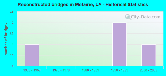
- Reconstructed bridges - Historical Statistics
- 11960-1969
- 01970-1979
- 01980-1989
- 21990-1999
- 12000-2009
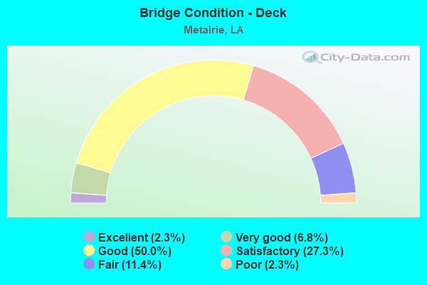
- Bridge Condition - Deck
- 2.3%Excellent
- 6.8%Very good
- 50.0%Good
- 27.3%Satisfactory
- 11.4%Fair
- 2.3%Poor
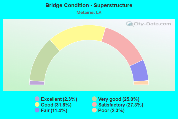
- Bridge Condition - Superstructure
- 2.3%Excellent
- 25.0%Very good
- 31.8%Good
- 27.3%Satisfactory
- 11.4%Fair
- 2.3%Poor
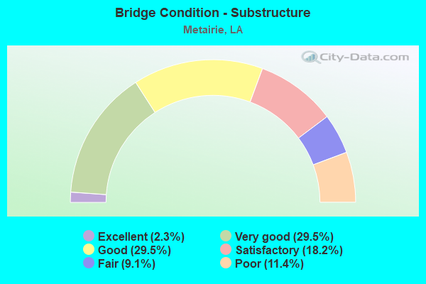
- Bridge Condition - Substructure
- 2.3%Excellent
- 29.5%Very good
- 29.5%Good
- 18.2%Satisfactory
- 9.1%Fair
- 11.4%Poor

- Bridge Condition - Channel
- 1.1%Excellent
- 66.7%Very good
- 29.0%Good
- 3.2%Satisfactory
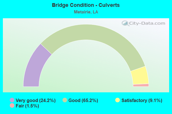
- Bridge Condition - Culverts
- 24.2%Very good
- 65.2%Good
- 9.1%Satisfactory
- 1.5%Fair
Find on map >> Show street view
Structure Number: 22630003901331, Location: 0.1 MILE WEST OF DAVID DR (Lat: 30.005350, Lng: -90.222389), Route carried "on" structure: County highway , Year Built: 2005, Status: Open, Structure Length: 3.84m (12.60ft), Design Load: HS 20, Features Intersected: SONIAT CANAL, Facility Carried by Structure: VETERANS BLVD
Minimum Vertical Clearance: 30+ m (98+ ft), Kilometerpoint: 0.000, Lanes on structure: 8, Base Highway Network: Yes, Owner: County Highway Agency, Approaching Roadway Width: 34.4m (112.9ft), Skew: 31 degrees, Material/Design: Concrete, Design/Construction: Culvert, Number Of Spans In Main Unit: 3, Length of Maximum Span: 12.8m (42.0ft), Curb or Sidewalk Widths: Left: 1.5m (4.9ft), Right: 1.5m (4.9ft), Curb-To-Curb Width: 3.4m (11.2ft), Out-to-Out Width: 45.0m (147.6ft)
Condition: Channel: Very good, Culverts: Good, Operating Rating: 48.9 metric tons, Method Used To Determine Operating Rating: Load and Resistance Factor Rating (LRFR) rating reported by rating factor(RF) method using HL-93 loadings, Inventory Rating: 37.6 metric tons, Method Used To Determine Inventory Rating: Load and Resistance Factor Rating (LRFR) rating reported by rating factor(RF) method using HL-93 loadings, Structural Evaluation: Better than present minimum criteria, Deck Geometry: High priority of replacement, Waterway Adequacy: Equal to present desirable criteria, Approach Roadway Alignment: Equal to present desirable criteria, Designated Inspection Frequency: Every 24 months, Inspection Date: May 2021, Deck Structure Type: Concrete Cast-file-Place
Find on map >> Show street view
Structure Number: 22630004901211, Location: 0.4MI.NORTH OF I 10 (Lat: 30.006139, Lng: -90.201019), Route carried "on" structure: County highway , Year Built: 1970, Status: Open, Structure Length: 0.70m (2.30ft), Design Load: H 15, Features Intersected: CANAL NO 3, Facility Carried by Structure: GREEN ACRE/VETERAN
Minimum Vertical Clearance: 30+ m (98+ ft), Kilometerpoint: 0.000, Lanes on structure: 2, Owner: County Highway Agency, Approaching Roadway Width: 7.6m (24.9ft), Skew: 2 degrees, Material/Design: Concrete, Design/Construction: Culvert, Number Of Spans In Main Unit: 2, Length of Maximum Span: 3.0m (9.8ft), Curb-To-Curb Width: 7.6m (24.9ft), Out-to-Out Width: 22.9m (75.1ft)
Condition: Channel: Good, Culverts: Good, Operating Rating: 42.1 metric tons, Method Used To Determine Operating Rating: Load and Resistance Factor Rating (LRFR) rating reported by rating factor(RF) method using HL-93 loadings, Inventory Rating: 32.4 metric tons, Method Used To Determine Inventory Rating: Load and Resistance Factor Rating (LRFR) rating reported by rating factor(RF) method using HL-93 loadings, Structural Evaluation: Better than present minimum criteria, Deck Geometry: Equal to present minimum criteria, Waterway Adequacy: Better than present minimum criteria, Approach Roadway Alignment: Equal to present minimum criteria, Designated Inspection Frequency: Every 24 months, Inspection Date: April 2021
Find on map >> Show street view
Structure Number: 22630004901221, Location: U2630004901221 (Lat: 30.006431, Lng: -90.202669), Route carried "on" structure: County highway , Year Built: 1970, Status: Open, Structure Length: 1.77m (5.81ft), Design Load: HS 20, Features Intersected: CANAL NO.3, Facility Carried by Structure: CLUB DR
Minimum Vertical Clearance: 30+ m (98+ ft), Kilometerpoint: 0.000, Lanes on structure: 2, Owner: County Highway Agency, Approaching Roadway Width: 8.2m (26.9ft), Material/Design: Concrete, Design/Construction: Channel Beam, Number Of Spans In Main Unit: 3, Length of Maximum Span: 5.8m (19.0ft), Curb or Sidewalk Widths: Left: 0.0m, Right: 1.0m (3.3ft), Curb-To-Curb Width: 7.2m (23.6ft), Out-to-Out Width: 9.4m (30.8ft)
Condition: Deck: Satisfactory, Superstructure: Satisfactory, Substructure: Satisfactory, Channel: Good, Operating Rating: 40.8 metric tons, Method Used To Determine Operating Rating: Allowable Stress (AS), Inventory Rating: 19.0 metric tons, Method Used To Determine Inventory Rating: Allowable Stress (AS), Structural Evaluation: Somewhat better than minimum adequacy, Deck Geometry: Somewhat better than minimum adequacy, Waterway Adequacy: Better than present minimum criteria, Approach Roadway Alignment: Equal to present minimum criteria, Designated Inspection Frequency: Every 24 months, Inspection Date: April 2021, Deck Structure Type: Concrete Precast Panels, Wearing Surface/Protective System: Wearing Surface: Monolithic Concrete
Find on map >> Show street view
Structure Number: 22630004901231, Location: 0.0 MI. N.OF VETERAN (Lat: 30.006289, Lng: -90.204419), Route carried "on" structure: County highway , Year Built: 1966, Status: Open, Structure Length: 2.44m (8.01ft), Design Load: HS 20, Features Intersected: CANAL #3, Facility Carried by Structure: BISSONET DR
Minimum Vertical Clearance: 30+ m (98+ ft), Kilometerpoint: 0.000, Lanes on structure: 2, Owner: County Highway Agency, Approaching Roadway Width: 12.8m (42.0ft), Material/Design: Concrete, Design/Construction: Slab, Number Of Spans In Main Unit: 4, Length of Maximum Span: 6.1m (20.0ft), Curb-To-Curb Width: 8.8m (28.9ft), Out-to-Out Width: 10.2m (33.5ft)
Condition: Deck: Satisfactory, Superstructure: Satisfactory, Substructure: Good, Channel: Good, Operating Rating: 43.7 metric tons, Method Used To Determine Operating Rating: Load and Resistance Factor Rating (LRFR) rating reported by rating factor(RF) method using HL-93 loadings, Inventory Rating: 33.7 metric tons, Method Used To Determine Inventory Rating: Load and Resistance Factor Rating (LRFR) rating reported by rating factor(RF) method using HL-93 loadings, Structural Evaluation: Equal to present minimum criteria, Deck Geometry: Better than present minimum criteria, Waterway Adequacy: Better than present minimum criteria, Approach Roadway Alignment: Better than present minimum criteria, Designated Inspection Frequency: Every 24 months, Inspection Date: April 2021, Deck Structure Type: Concrete Cast-file-Place, Wearing Surface/Protective System: Wearing Surface: Monolithic Concrete
Find on map >> Show street view
Structure Number: 22630004901251, Location: W. CANAL DR @ ACADEMY DR. (Lat: 30.006989, Lng: -90.209950), Route carried "on" structure: City street , Year Built: 1999, Status: Open, Structure Length: 7.62m (25.00ft), Design Load: HS 20, Features Intersected: ELMWOOD CANAL, Facility Carried by Structure: W. Canal Dr.
Minimum Vertical Clearance: 30+ m (98+ ft), Kilometerpoint: 0.000, Lanes on structure: 2, Owner: County Highway Agency, Approaching Roadway Width: 7.6m (24.9ft), Skew: 2 degrees, Material/Design: Concrete, Design/Construction: Slab, Number Of Spans In Main Unit: 5, Length of Maximum Span: 15.2m (49.9ft), Curb or Sidewalk Widths: Left: 1.2m (3.9ft), Right: 0.0m, Curb-To-Curb Width: 9.7m (31.8ft), Out-to-Out Width: 11.9m (39.0ft)
Condition: Deck: Good, Superstructure: Very good, Substructure: Very good, Channel: Very good, Operating Rating: 45.4 metric tons, Method Used To Determine Operating Rating: Load and Resistance Factor Rating (LRFR) rating reported by rating factor(RF) method using HL-93 loadings, Inventory Rating: 31.1 metric tons, Method Used To Determine Inventory Rating: Load and Resistance Factor Rating (LRFR) rating reported by rating factor(RF) method using HL-93 loadings, Structural Evaluation: Better than present minimum criteria, Deck Geometry: Better than present minimum criteria, Waterway Adequacy: Equal to present desirable criteria, Approach Roadway Alignment: Better than present minimum criteria, Designated Inspection Frequency: Every 24 months, Underwater Inspection Frequency: Every 60 months, Inspection Date: May 2021, Underwater Inspection Date: December 2018, Deck Structure Type: Concrete Cast-file-Place
Find on map >> Show street view
Structure Number: 22630005900871, Location: 0.5 MI.E OF CAUSEWAY (Lat: 30.009131, Lng: -90.145139), Route carried "on" structure: County highway , Year Built: 1960, Status: Posted for load, Structure Length: 2.44m (8.01ft), Design Load: H 15, Features Intersected: BONNABEL CANAL, Facility Carried by Structure: Nero St
Minimum Vertical Clearance: 30+ m (98+ ft), Kilometerpoint: 0.000, Lanes on structure: 2, Owner: County Highway Agency, Approaching Roadway Width: 7.0m (23.0ft), Material/Design: Concrete, Design/Construction: Tee Beam, Number Of Spans In Main Unit: 4, Length of Maximum Span: 6.1m (20.0ft), Curb or Sidewalk Widths: Left: 0.9m (3.0ft), Right: 0.0m, Curb-To-Curb Width: 7.1m (23.3ft), Out-to-Out Width: 8.6m (28.2ft)
Condition: Deck: Satisfactory, Superstructure: Fair, Substructure: Fair, Channel: Very good, Operating Rating: 29.0 metric tons, Method Used To Determine Operating Rating: Allowable Stress (AS), Inventory Rating: 11.8 metric tons, Method Used To Determine Inventory Rating: Allowable Stress (AS), Structural Evaluation: Meets minimum limits, Deck Geometry: Somewhat better than minimum adequacy, Waterway Adequacy: Equal to present minimum criteria, Approach Roadway Alignment: Equal to present minimum criteria, Bridge Posting: Required (Relationship of Operating Rating to Maximum Legal Load: 0.1 - 9.9% below), Designated Inspection Frequency: Every 24 months, Inspection Date: May 2021, Deck Structure Type: Concrete Precast Panels, Wearing Surface/Protective System: Wearing Surface: Monolithic Concrete
Find on map >> Show street view
Structure Number: 22630008900791, Location: 1.5 MI N OF VETERANS (Lat: 30.013411, Lng: -90.132111), Route carried "on" structure: County highway , Year Built: 1970, Status: Open, Structure Length: 0.70m (2.30ft), Design Load: HS 20, Features Intersected: CANAL NO. 2, Facility Carried by Structure: Oaklawn Dr
Minimum Vertical Clearance: 30+ m (98+ ft), Kilometerpoint: 0.000, Lanes on structure: 2, Owner: County Highway Agency, Approaching Roadway Width: 7.6m (24.9ft), Material/Design: Concrete, Design/Construction: Culvert, Number Of Spans In Main Unit: 2, Length of Maximum Span: 3.0m (9.8ft), Curb-To-Curb Width: 7.7m (25.3ft), Out-to-Out Width: 20.6m (67.6ft)
Condition: Channel: Very good, Culverts: Good, Operating Rating: 42.1 metric tons, Method Used To Determine Operating Rating: Load and Resistance Factor Rating (LRFR) rating reported by rating factor(RF) method using HL-93 loadings, Inventory Rating: 32.4 metric tons, Method Used To Determine Inventory Rating: Load and Resistance Factor Rating (LRFR) rating reported by rating factor(RF) method using HL-93 loadings, Structural Evaluation: Better than present minimum criteria, Deck Geometry: Equal to present minimum criteria, Waterway Adequacy: Better than present minimum criteria, Approach Roadway Alignment: Better than present minimum criteria, Designated Inspection Frequency: Every 24 months, Inspection Date: April 2021
Find on map >> Show street view
Structure Number: 22630008900821, Location: 0.4MI.N.OF.VETERANS (Lat: 30.013569, Lng: -90.137389), Route carried "on" structure: County highway , Year Built: 1970, Status: Open, Structure Length: 1.71m (5.61ft), Design Load: HS 20, Features Intersected: CANAL NO.2, Facility Carried by Structure: Homestead Ave
Minimum Vertical Clearance: 30+ m (98+ ft), Kilometerpoint: 0.000, Lanes on structure: 2, Owner: County Highway Agency, Approaching Roadway Width: 8.2m (26.9ft), Material/Design: Concrete, Design/Construction: Channel Beam, Number Of Spans In Main Unit: 3, Length of Maximum Span: 5.8m (19.0ft), Curb or Sidewalk Widths: Left: 1.2m (3.9ft), Right: 1.2m (3.9ft), Curb-To-Curb Width: 8.3m (27.2ft), Out-to-Out Width: 11.5m (37.7ft)
Condition: Deck: Good, Superstructure: Good, Substructure: Poor, Channel: Very good, Operating Rating: 35.4 metric tons, Method Used To Determine Operating Rating: Allowable Stress (AS), Inventory Rating: 16.3 metric tons, Method Used To Determine Inventory Rating: Allowable Stress (AS), Structural Evaluation: Meets minimum limits, Deck Geometry: Equal to present minimum criteria, Waterway Adequacy: Better than present minimum criteria, Approach Roadway Alignment: Equal to present minimum criteria, Length Of Structure Improvement: 2.41m (7.91ft), Designated Inspection Frequency: Every 24 months, Other Special Inspection Frequency: Every 12 months, Inspection Date: April 2021, Other Special Inspection Date: April 2020, Bridge Improvement Cost: $143,000, Total Project Cost: $214,000 ( Estimate for 2016), Deck Structure Type: Concrete Precast Panels, Wearing Surface/Protective System: Wearing Surface: Bituminous
Find on map >> Show street view
Structure Number: 22630008900851, Location: 0.8 MI. N.OF VETERAN (Lat: 30.013789, Lng: -90.141981), Route carried "on" structure: County highway , Year Built: 1972, Status: Open, Structure Length: 0.73m (2.40ft), Average Daily Traffic: 5,000 (year 1979), Average Future Daily Traffic: 8,500 (year 2036), Design Load: HS 20, Features Intersected: CANAL 2, Facility Carried by Structure: Bonnabel BLVD
Minimum Vertical Clearance: 30+ m (98+ ft), Kilometerpoint: 0.000, Lanes on structure: 4, Owner: County Highway Agency, Approaching Roadway Width: 18.3m (60.0ft), Skew: 30 degrees, Material/Design: Concrete, Design/Construction: Culvert, Number Of Spans In Main Unit: 2, Length of Maximum Span: 3.0m (9.8ft), Curb or Sidewalk Widths: Left: 1.2m (3.9ft), Right: 1.5m (4.9ft)
Condition: Channel: Very good, Culverts: Good, Operating Rating: 42.1 metric tons, Method Used To Determine Operating Rating: Load and Resistance Factor Rating (LRFR) rating reported by rating factor(RF) method using HL-93 loadings, Inventory Rating: 32.4 metric tons, Method Used To Determine Inventory Rating: Load and Resistance Factor Rating (LRFR) rating reported by rating factor(RF) method using HL-93 loadings, Structural Evaluation: Better than present minimum criteria, Waterway Adequacy: Better than present minimum criteria, Approach Roadway Alignment: Better than present minimum criteria, Designated Inspection Frequency: Every 24 months, Inspection Date: April 2021
Find on map >> Show street view
Structure Number: 22630008900871, Location: 0.4 MI.E.OF CAUSEWAY BLVD (Lat: 30.013561, Lng: -90.145069), Route carried "on" structure: County highway , Year Built: 1995, Status: Open, Structure Length: 1.43m (4.69ft), Design Load: HS 20, Features Intersected: BONNABEL CANAL, Facility Carried by Structure: W Esplanade Ave S
Minimum Vertical Clearance: 30+ m (98+ ft), Kilometerpoint: 0.000, Lanes on structure: 4, Owner: County Highway Agency, Approaching Roadway Width: 15.9m (52.2ft), Skew: 30 degrees, Material/Design: Concrete, Design/Construction: Culvert, Number Of Spans In Main Unit: 2, Length of Maximum Span: 7.0m (23.0ft), Curb or Sidewalk Widths: Left: 1.2m (3.9ft), Right: 1.2m (3.9ft), Curb-To-Curb Width: 15.9m (52.2ft), Out-to-Out Width: 79.6m (261.2ft)
Condition: Channel: Very good, Culverts: Very good, Operating Rating: 42.1 metric tons, Method Used To Determine Operating Rating: Load and Resistance Factor Rating (LRFR) rating reported by rating factor(RF) method using HL-93 loadings, Inventory Rating: 32.4 metric tons, Method Used To Determine Inventory Rating: Load and Resistance Factor Rating (LRFR) rating reported by rating factor(RF) method using HL-93 loadings, Structural Evaluation: Equal to present desirable criteria, Deck Geometry: Meets minimum limits, Waterway Adequacy: Equal to present desirable criteria, Approach Roadway Alignment: Better than present minimum criteria, Designated Inspection Frequency: Every 24 months, Inspection Date: May 2021, Deck Structure Type: Concrete Cast-file-Place
Find on map >> Show street view
Structure Number: 22630008900881, Location: 0.5 MI.N.OF.VETERANS (Lat: 30.013600, Lng: -90.146511), Route carried "on" structure: County highway , Year Built: 1960, Status: Open, Structure Length: 1.83m (6.00ft), Design Load: H 15, Features Intersected: CANAL NO. 2, Facility Carried by Structure: Melody Dr
Minimum Vertical Clearance: 30+ m (98+ ft), Kilometerpoint: 0.000, Lanes on structure: 2, Owner: County Highway Agency, Approaching Roadway Width: 7.3m (24.0ft), Material/Design: Concrete, Design/Construction: Channel Beam, Number Of Spans In Main Unit: 3, Length of Maximum Span: 6.1m (20.0ft), Curb or Sidewalk Widths: Left: 0.9m (3.0ft), Right: 0.9m (3.0ft), Curb-To-Curb Width: 7.3m (24.0ft), Out-to-Out Width: 9.8m (32.2ft)
Condition: Deck: Good, Superstructure: Good, Substructure: Poor, Channel: Very good, Operating Rating: 39.9 metric tons, Method Used To Determine Operating Rating: Allowable Stress (AS), Inventory Rating: 18.1 metric tons, Method Used To Determine Inventory Rating: Allowable Stress (AS), Structural Evaluation: Meets minimum limits, Deck Geometry: Equal to present minimum criteria, Waterway Adequacy: Better than present minimum criteria, Approach Roadway Alignment: Equal to present minimum criteria, Designated Inspection Frequency: Every 24 months, Other Special Inspection Frequency: Every 12 months, Inspection Date: April 2021, Other Special Inspection Date: April 2020, Deck Structure Type: Concrete Precast Panels, Wearing Surface/Protective System: Wearing Surface: Monolithic Concrete
Find on map >> Show street view
Structure Number: 22630009900901, Location: 0.1 MI EAST OF CAUSEWAY (Lat: 30.014019, Lng: -90.153181), Route carried "on" structure: County highway , Year Built: 2003, Status: Open, Structure Length: 0.73m (2.40ft), Design Load: HS 20, Features Intersected: CANAL NO. 2, Facility Carried by Structure: RIDGELAKE DR
Minimum Vertical Clearance: 5.16m (16.93ft), Kilometerpoint: 0.000, Lanes on structure: 3, Owner: County Highway Agency, Approaching Roadway Width: 7.3m (24.0ft), Skew: 20 degrees, Material/Design: Concrete, Design/Construction: Culvert, Number Of Spans In Main Unit: 1, Length of Maximum Span: 7.3m (24.0ft), Curb or Sidewalk Widths: Left: 1.8m (5.9ft), Right: 1.8m (5.9ft), Curb-To-Curb Width: 11.3m (37.1ft), Out-to-Out Width: 24.6m (80.7ft)
Condition: Channel: Very good, Culverts: Very good, Operating Rating: 38.2 metric tons, Method Used To Determine Operating Rating: Load and Resistance Factor Rating (LRFR) rating reported by rating factor(RF) method using HL-93 loadings, Inventory Rating: 29.5 metric tons, Method Used To Determine Inventory Rating: Load and Resistance Factor Rating (LRFR) rating reported by rating factor(RF) method using HL-93 loadings, Structural Evaluation: Better than present minimum criteria, Deck Geometry: High priority of replacement, Waterway Adequacy: Equal to present desirable criteria, Approach Roadway Alignment: Equal to present desirable criteria, Designated Inspection Frequency: Every 24 months, Inspection Date: April 2021, Deck Structure Type: Concrete Cast-file-Place
Find on map >> Show street view
Structure Number: 22630009900911, Location: 0.55 MI W OF SEVERN AVE (Lat: 30.014761, Lng: -90.164131), Route carried "on" structure: County highway , Year Built: 1960, Status: Open, Structure Length: 1.13m (3.71ft), Design Load: HS 20, Features Intersected: CANAL NO 2, Facility Carried by Structure: W Esplanade Ave S
Minimum Vertical Clearance: 30+ m (98+ ft), Kilometerpoint: 0.000, Lanes on structure: 2, Owner: County Highway Agency, Approaching Roadway Width: 7.6m (24.9ft), Skew: 30 degrees, Material/Design: Concrete, Design/Construction: Culvert, Number Of Spans In Main Unit: 3, Length of Maximum Span: 3.4m (11.2ft), Curb or Sidewalk Widths: Left: 0.0m, Right: 1.2m (3.9ft)
Condition: Channel: Very good, Culverts: Good, Operating Rating: 42.1 metric tons, Method Used To Determine Operating Rating: Load and Resistance Factor Rating (LRFR) rating reported by rating factor(RF) method using HL-93 loadings, Inventory Rating: 32.4 metric tons, Method Used To Determine Inventory Rating: Load and Resistance Factor Rating (LRFR) rating reported by rating factor(RF) method using HL-93 loadings, Structural Evaluation: Better than present minimum criteria, Waterway Adequacy: Better than present minimum criteria, Approach Roadway Alignment: Better than present minimum criteria, Designated Inspection Frequency: Every 24 months, Inspection Date: April 2021
Find on map >> Show street view
Structure Number: 22630009900931, Location: 0.01 MI N. OF ESPLAN (Lat: 30.014250, Lng: -90.155000), Route carried "on" structure: County highway , Year Built: 1971, Status: Open, Structure Length: 0.91m (2.99ft), Average Daily Traffic: 12,200 (year 1979), Average Future Daily Traffic: 20,740 (year 2036), Design Load: HS 20, Features Intersected: CANAL 2, Facility Carried by Structure: CAUSEWAY BLVD
Minimum Vertical Clearance: 30+ m (98+ ft), Kilometerpoint: 0.000, Lanes on structure: 10, Owner: County Highway Agency, Approaching Roadway Width: 32.9m (107.9ft), Skew: 30 degrees, Material/Design: Concrete, Design/Construction: Culvert, Number Of Spans In Main Unit: 4, Length of Maximum Span: 2.4m (7.9ft), Curb or Sidewalk Widths: Left: 2.6m (8.5ft), Right: 2.6m (8.5ft)
Condition: Channel: Very good, Culverts: Very good, Operating Rating: 42.1 metric tons, Method Used To Determine Operating Rating: Load and Resistance Factor Rating (LRFR) rating reported by rating factor(RF) method using HL-93 loadings, Inventory Rating: 32.4 metric tons, Method Used To Determine Inventory Rating: Load and Resistance Factor Rating (LRFR) rating reported by rating factor(RF) method using HL-93 loadings, Structural Evaluation: Equal to present desirable criteria, Waterway Adequacy: Better than present minimum criteria, Approach Roadway Alignment: Equal to present desirable criteria, Designated Inspection Frequency: Every 24 months, Inspection Date: April 2021, Deck Structure Type: Concrete Cast-file-Place
Find on map >> Show street view
Structure Number: 22630009900951, Location: 2.5 MI W OF CAUSEWAY BLVD (Lat: 30.014419, Lng: -90.158981), Route carried "on" structure: County highway , Year Built: 1960, Status: Open, Structure Length: 1.10m (3.61ft), Design Load: HS 20, Features Intersected: CANAL NO 2, Facility Carried by Structure: SEVERN AVE
Minimum Vertical Clearance: 30+ m (98+ ft), Kilometerpoint: 0.000, Lanes on structure: 7, Owner: County Highway Agency, Approaching Roadway Width: 25.3m (83.0ft), Skew: 30 degrees, Material/Design: Concrete, Design/Construction: Culvert, Number Of Spans In Main Unit: 3, Length of Maximum Span: 3.0m (9.8ft), Curb or Sidewalk Widths: Left: 1.4m (4.6ft), Right: 0.0m
Condition: Channel: Very good, Culverts: Very good, Operating Rating: 42.1 metric tons, Method Used To Determine Operating Rating: Load and Resistance Factor Rating (LRFR) rating reported by rating factor(RF) method using HL-93 loadings, Inventory Rating: 32.4 metric tons, Method Used To Determine Inventory Rating: Load and Resistance Factor Rating (LRFR) rating reported by rating factor(RF) method using HL-93 loadings, Structural Evaluation: Equal to present desirable criteria, Waterway Adequacy: Better than present minimum criteria, Approach Roadway Alignment: Equal to present desirable criteria, Designated Inspection Frequency: Every 24 months, Inspection Date: April 2021
Find on map >> Show street view
Structure Number: 22630009900971, Location: 1.5 MI N OF VETERANS (Lat: 30.014611, Lng: -90.161700), Route carried "on" structure: County highway , Year Built: 1970, Status: Open, Structure Length: 0.79m (2.59ft), Design Load: HS 20, Features Intersected: CANAL NO.2, Facility Carried by Structure: Edenborn Ave
Minimum Vertical Clearance: 30+ m (98+ ft), Kilometerpoint: 0.000, Lanes on structure: 2, Owner: County Highway Agency, Approaching Roadway Width: 7.6m (24.9ft), Material/Design: Concrete, Design/Construction: Culvert, Number Of Spans In Main Unit: 2, Length of Maximum Span: 3.7m (12.1ft), Curb or Sidewalk Widths: Left: 1.2m (3.9ft), Right: 0.0m, Curb-To-Curb Width: 7.6m (24.9ft), Out-to-Out Width: 11.1m (36.4ft)
Condition: Channel: Very good, Culverts: Good, Operating Rating: 42.1 metric tons, Method Used To Determine Operating Rating: Load and Resistance Factor Rating (LRFR) rating reported by rating factor(RF) method using HL-93 loadings, Inventory Rating: 32.4 metric tons, Method Used To Determine Inventory Rating: Load and Resistance Factor Rating (LRFR) rating reported by rating factor(RF) method using HL-93 loadings, Structural Evaluation: Better than present minimum criteria, Deck Geometry: Equal to present minimum criteria, Waterway Adequacy: Better than present minimum criteria, Approach Roadway Alignment: Equal to present minimum criteria, Designated Inspection Frequency: Every 24 months, Inspection Date: April 2021
Find on map >> Show street view
Structure Number: 22630009901011, Location: 1.2 MI. N. OF VETERA (Lat: 30.015061, Lng: -90.168750), Route carried "on" structure: County highway , Year Built: 1975, Status: Open, Structure Length: 1.10m (3.61ft), Design Load: HS 20, Features Intersected: CANAL NO. 2, Facility Carried by Structure: W Esplanade Ave S
Minimum Vertical Clearance: 30+ m (98+ ft), Kilometerpoint: 0.000, Lanes on structure: 2, Owner: County Highway Agency, Approaching Roadway Width: 15.2m (49.9ft), Skew: 30 degrees, Material/Design: Concrete, Design/Construction: Culvert, Number Of Spans In Main Unit: 3, Length of Maximum Span: 3.4m (11.2ft), Curb or Sidewalk Widths: Left: 0.0m, Right: 1.2m (3.9ft)
Condition: Channel: Good, Culverts: Very good, Operating Rating: 42.1 metric tons, Method Used To Determine Operating Rating: Load and Resistance Factor Rating (LRFR) rating reported by rating factor(RF) method using HL-93 loadings, Inventory Rating: 32.4 metric tons, Method Used To Determine Inventory Rating: Load and Resistance Factor Rating (LRFR) rating reported by rating factor(RF) method using HL-93 loadings, Structural Evaluation: Equal to present desirable criteria, Waterway Adequacy: Better than present minimum criteria, Approach Roadway Alignment: Better than present minimum criteria, Designated Inspection Frequency: Every 24 months, Inspection Date: April 2021
Find on map >> Show street view
Structure Number: 22630009901031, Location: 0.1 MI W OF SEVERN AVENUE (Lat: 30.015289, Lng: -90.172389), Route carried "on" structure: County highway , Year Built: 1960, Status: Open, Structure Length: 1.13m (3.71ft), Design Load: HS 20, Features Intersected: CANAL NO 2, Facility Carried by Structure: W Esplanade Ave S
Minimum Vertical Clearance: 30+ m (98+ ft), Kilometerpoint: 0.000, Lanes on structure: 2, Owner: County Highway Agency, Approaching Roadway Width: 7.6m (24.9ft), Skew: 30 degrees, Material/Design: Concrete, Design/Construction: Culvert, Number Of Spans In Main Unit: 3, Length of Maximum Span: 3.4m (11.2ft), Curb or Sidewalk Widths: Left: 0.0m, Right: 1.2m (3.9ft)
Condition: Channel: Very good, Culverts: Satisfactory, Operating Rating: 42.1 metric tons, Method Used To Determine Operating Rating: Load and Resistance Factor Rating (LRFR) rating reported by rating factor(RF) method using HL-93 loadings, Inventory Rating: 32.4 metric tons, Method Used To Determine Inventory Rating: Load and Resistance Factor Rating (LRFR) rating reported by rating factor(RF) method using HL-93 loadings, Structural Evaluation: Equal to present minimum criteria, Waterway Adequacy: Better than present minimum criteria, Approach Roadway Alignment: Better than present minimum criteria, Designated Inspection Frequency: Every 24 months, Inspection Date: April 2021
Find on map >> Show street view
Structure Number: 22630009901051, Location: 0.15 MI W OF SEVERN AVE (Lat: 30.015461, Lng: -90.174981), Route carried "on" structure: County highway , Year Built: 1960, Status: Open, Structure Length: 1.19m (3.90ft), Design Load: HS 20, Features Intersected: CANAL NO 2, Facility Carried by Structure: W Esplanade Ave S
Minimum Vertical Clearance: 30+ m (98+ ft), Kilometerpoint: 0.000, Lanes on structure: 3, Owner: County Highway Agency, Approaching Roadway Width: 8.2m (26.9ft), Skew: 30 degrees, Material/Design: Concrete, Design/Construction: Culvert, Number Of Spans In Main Unit: 3, Length of Maximum Span: 3.4m (11.2ft), Curb or Sidewalk Widths: Left: 0.0m, Right: 1.3m (4.3ft)
Condition: Channel: Very good, Culverts: Good, Operating Rating: 42.1 metric tons, Method Used To Determine Operating Rating: Load and Resistance Factor Rating (LRFR) rating reported by rating factor(RF) method using HL-93 loadings, Inventory Rating: 32.4 metric tons, Method Used To Determine Inventory Rating: Load and Resistance Factor Rating (LRFR) rating reported by rating factor(RF) method using HL-93 loadings, Structural Evaluation: Better than present minimum criteria, Waterway Adequacy: Better than present minimum criteria, Approach Roadway Alignment: Better than present minimum criteria, Designated Inspection Frequency: Every 24 months, Inspection Date: April 2021
Find on map >> Show street view
Structure Number: 22630010901081, Location: 0.1 MI. E OF HOUMA BLVD (Lat: 30.015661, Lng: -90.179900), Route carried "on" structure: City street , Year Built: 2002, Status: Open, Structure Length: 2.90m (9.51ft), Design Load: HS 20, Features Intersected: SUBURBAN CANAL, Facility Carried by Structure: W. ESPLANADE AVE
Minimum Vertical Clearance: 30+ m (98+ ft), Kilometerpoint: 0.000, Lanes on structure: 4, Owner: County Highway Agency, Approaching Roadway Width: 7.6m (24.9ft), Skew: 30 degrees, Material/Design: Concrete, Design/Construction: Culvert, Number Of Spans In Main Unit: 3, Length of Maximum Span: 10.1m (33.1ft), Curb or Sidewalk Widths: Left: 1.5m (4.9ft), Right: 1.5m (4.9ft), Curb-To-Curb Width: 15.5m (50.9ft), Out-to-Out Width: 58.1m (190.6ft)
Condition: Channel: Very good, Culverts: Satisfactory, Operating Rating: 40.8 metric tons, Method Used To Determine Operating Rating: Load and Resistance Factor Rating (LRFR) rating reported by rating factor(RF) method using HL-93 loadings, Inventory Rating: 31.4 metric tons, Method Used To Determine Inventory Rating: Load and Resistance Factor Rating (LRFR) rating reported by rating factor(RF) method using HL-93 loadings, Structural Evaluation: Equal to present minimum criteria, Deck Geometry: Meets minimum limits, Waterway Adequacy: Equal to present desirable criteria, Approach Roadway Alignment: Equal to present desirable criteria, Designated Inspection Frequency: Every 24 months, Inspection Date: May 2021, Deck Structure Type: Concrete Cast-file-Place
Find on map >> Show street view
Structure Number: 22630010901191, Location: 0.7MI.N.OF VETERANS (Lat: 30.017011, Lng: -90.198511), Route carried "on" structure: County highway , Year Built: 1960, Status: Open, Structure Length: 0.76m (2.49ft), Average Daily Traffic: 26,950 (year 1979), Average Future Daily Traffic: 45,815 (year 2036), Design Load: HS 20, Features Intersected: CANAL NUMBER 2, Facility Carried by Structure: Transcontinental D
Minimum Vertical Clearance: 30+ m (98+ ft), Kilometerpoint: 0.000, Lanes on structure: 6, Owner: County Highway Agency, Approaching Roadway Width: 7.6m (24.9ft), Material/Design: Concrete, Design/Construction: Culvert, Number Of Spans In Main Unit: 2, Length of Maximum Span: 3.4m (11.2ft), Curb or Sidewalk Widths: Left: 1.2m (3.9ft), Right: 0.0m
Condition: Channel: Very good, Culverts: Good, Operating Rating: 42.1 metric tons, Method Used To Determine Operating Rating: Load and Resistance Factor Rating (LRFR) rating reported by rating factor(RF) method using HL-93 loadings, Inventory Rating: 32.4 metric tons, Method Used To Determine Inventory Rating: Load and Resistance Factor Rating (LRFR) rating reported by rating factor(RF) method using HL-93 loadings, Structural Evaluation: Better than present minimum criteria, Waterway Adequacy: Better than present minimum criteria, Approach Roadway Alignment: Better than present minimum criteria, Designated Inspection Frequency: Every 24 months, Inspection Date: April 2021
Find on map >> Show street view
Structure Number: 22630011901251, Location: 1.0 M E OF POWER BLVD (Lat: 30.017650, Lng: -90.208361), Route carried "on" structure: County highway , Year Built: 1989, Status: Open, Structure Length: 1.01m (3.31ft), Design Load: HS 20, Features Intersected: CANAL NUMBER 2, Facility Carried by Structure: W Esplanade Ave S
Minimum Vertical Clearance: 30+ m (98+ ft), Kilometerpoint: 0.000, Lanes on structure: 2, Owner: County Highway Agency, Approaching Roadway Width: 17.1m (56.1ft), Skew: 30 degrees, Material/Design: Concrete, Design/Construction: Culvert, Number Of Spans In Main Unit: 3, Length of Maximum Span: 2.7m (8.9ft), Curb-To-Curb Width: 17.4m (57.1ft), Out-to-Out Width: 30.5m (100.1ft)
Condition: Channel: Good, Culverts: Fair, Operating Rating: 42.1 metric tons, Method Used To Determine Operating Rating: Load and Resistance Factor Rating (LRFR) rating reported by rating factor(RF) method using HL-93 loadings, Inventory Rating: 32.4 metric tons, Method Used To Determine Inventory Rating: Load and Resistance Factor Rating (LRFR) rating reported by rating factor(RF) method using HL-93 loadings, Structural Evaluation: Somewhat better than minimum adequacy, Deck Geometry: Superior to present desirable criteria, Waterway Adequacy: Better than present minimum criteria, Approach Roadway Alignment: Better than present minimum criteria, Designated Inspection Frequency: Every 24 months, Underwater Inspection Frequency: Every 60 months, Inspection Date: April 2021, Underwater Inspection Date: Febuary 2019, Deck Structure Type: Concrete Cast-file-Place
Find on map >> Show street view
Structure Number: 22630011901321, Location: 0.0 MI.FROM W.ESPLANADE (Lat: 30.018450, Lng: -90.219619), Route carried "on" structure: County highway , Year Built: 1983, Status: Open, Structure Length: 0.98m (3.22ft), Design Load: HS 20, Features Intersected: CANAL NO. 2, Facility Carried by Structure: W Esplanade Ave S
Minimum Vertical Clearance: 30+ m (98+ ft), Kilometerpoint: 0.000, Lanes on structure: 2, Owner: County Highway Agency, Approaching Roadway Width: 8.2m (26.9ft), Skew: 30 degrees, Material/Design: Concrete, Design/Construction: Culvert, Number Of Spans In Main Unit: 3, Length of Maximum Span: 2.7m (8.9ft)
Condition: Channel: Good, Culverts: Good, Operating Rating: 42.1 metric tons, Method Used To Determine Operating Rating: Load and Resistance Factor Rating (LRFR) rating reported by rating factor(RF) method using HL-93 loadings, Inventory Rating: 32.4 metric tons, Method Used To Determine Inventory Rating: Load and Resistance Factor Rating (LRFR) rating reported by rating factor(RF) method using HL-93 loadings, Structural Evaluation: Better than present minimum criteria, Waterway Adequacy: Better than present minimum criteria, Approach Roadway Alignment: Better than present minimum criteria, Designated Inspection Frequency: Every 24 months, Inspection Date: April 2021, Deck Structure Type: Concrete Cast-file-Place
Find on map >> Show street view
Structure Number: 22630011901341, Location: 1.4 Mi E of LA 49 (Lat: 30.018239, Lng: -90.216211), Route carried "on" structure: City street , Year Built: 1983, Status: Open, Structure Length: 0.98m (3.22ft), Design Load: HS 20, Features Intersected: CANAL NO.2, Facility Carried by Structure: ESPLANADE X-OVER
Minimum Vertical Clearance: 30+ m (98+ ft), Kilometerpoint: 0.000, Lanes on structure: 2, Owner: County Highway Agency, Approaching Roadway Width: 8.2m (26.9ft), Skew: 30 degrees, Material/Design: Concrete, Design/Construction: Culvert, Number Of Spans In Main Unit: 3, Length of Maximum Span: 2.7m (8.9ft)
Condition: Channel: Good, Culverts: Good, Operating Rating: 42.1 metric tons, Method Used To Determine Operating Rating: Load and Resistance Factor Rating (LRFR) rating reported by rating factor(RF) method using HL-93 loadings, Inventory Rating: 32.4 metric tons, Method Used To Determine Inventory Rating: Load and Resistance Factor Rating (LRFR) rating reported by rating factor(RF) method using HL-93 loadings, Structural Evaluation: Better than present minimum criteria, Waterway Adequacy: Better than present minimum criteria, Approach Roadway Alignment: Better than present minimum criteria, Designated Inspection Frequency: Every 24 months, Inspection Date: April 2021, Deck Structure Type: Concrete Cast-file-Place
Find on map >> Show street view
Structure Number: 22630011901351, Location: 0.2EAST OF WILLIAMS (Lat: 30.018761, Lng: -90.224739), Route carried "on" structure: County highway , Year Built: 1990, Status: Open, Structure Length: 0.79m (2.59ft), Average Daily Traffic: 14,000 (year 1979), Average Future Daily Traffic: 23,800 (year 2036), Design Load: HS 20, Features Intersected: CANAL 2, Facility Carried by Structure: Power BLVD
Minimum Vertical Clearance: 30+ m (98+ ft), Kilometerpoint: 0.000, Lanes on structure: 6, Owner: County Highway Agency, Approaching Roadway Width: 13.4m (44.0ft), Skew: 30 degrees, Material/Design: Concrete, Design/Construction: Culvert, Number Of Spans In Main Unit: 3, Length of Maximum Span: 3.0m (9.8ft), Curb-To-Curb Width: 14.9m (48.9ft), Out-to-Out Width: 38.7m (127.0ft)
Condition: Channel: Good, Culverts: Good, Operating Rating: 42.1 metric tons, Method Used To Determine Operating Rating: Load and Resistance Factor Rating (LRFR) rating reported by rating factor(RF) method using HL-93 loadings, Inventory Rating: 32.4 metric tons, Method Used To Determine Inventory Rating: Load and Resistance Factor Rating (LRFR) rating reported by rating factor(RF) method using HL-93 loadings, Structural Evaluation: Better than present minimum criteria, Deck Geometry: High priority of replacement, Waterway Adequacy: Better than present minimum criteria, Approach Roadway Alignment: Better than present minimum criteria, Length Of Structure Improvement: 1.40m (4.59ft), Designated Inspection Frequency: Every 24 months, Inspection Date: April 2021, Bridge Improvement Cost: $146,000, Total Project Cost: $219,000 ( Estimate for 2016), Deck Structure Type: Concrete Cast-file-Place
Find on map >> Show street view
Structure Number: 22630012901081, Location: 2500 FT. EAST OF CLEARVIE (Lat: 30.019850, Lng: -90.180250), Route carried "on" structure: County highway , Year Built: 2005, Year Reconstructed: 2006, Status: Open, Structure Length: 4.82m (15.81ft), Average Daily Traffic: 1,000 (year 1989), Average Future Daily Traffic: 1,700 (year 2036), Design Load: HS 20, Features Intersected: CANAL, Facility Carried by Structure: Avron BLVD
Minimum Vertical Clearance: 30+ m (98+ ft), Kilometerpoint: 0.000, Lanes on structure: 2, Owner: County Highway Agency, Approaching Roadway Width: 8.5m (27.9ft), Skew: 39 degrees, Material/Design: Prestressed concrete, Design/Construction: Stringer/Multi-beam, Number Of Spans In Main Unit: 5, Length of Maximum Span: 10.4m (34.1ft), Curb or Sidewalk Widths: Left: 1.2m (3.9ft), Right: 1.2m (3.9ft), Curb-To-Curb Width: 8.5m (27.9ft), Out-to-Out Width: 8.5m (27.9ft)
Condition: Deck: Very good, Superstructure: Very good, Substructure: Good, Channel: Very good, Operating Rating: 49.2 metric tons, Method Used To Determine Operating Rating: Load and Resistance Factor Rating (LRFR) rating reported by rating factor(RF) method using HL-93 loadings, Inventory Rating: 32.4 metric tons, Method Used To Determine Inventory Rating: Load and Resistance Factor Rating (LRFR) rating reported by rating factor(RF) method using HL-93 loadings, Structural Evaluation: Better than present minimum criteria, Deck Geometry: Somewhat better than minimum adequacy, Waterway Adequacy: Equal to present desirable criteria, Approach Roadway Alignment: Equal to present desirable criteria, Designated Inspection Frequency: Every 24 months, Underwater Inspection Frequency: Every 60 months, Inspection Date: May 2021, Underwater Inspection Date: July 2019, Deck Structure Type: Concrete Cast-file-Place, Wearing Surface/Protective System: Wearing Surface: Monolithic Concrete
Find on map >> Show street view
Structure Number: 22630017901351, Location: 0.80 MI N. OF W ESPLANADE (Lat: 30.029331, Lng: -90.217881), Route carried "on" structure: County highway , Year Built: 1964, Status: Open, Structure Length: 1.16m (3.81ft), Design Load: HS 20, Features Intersected: CANAL NO. 1, Facility Carried by Structure: Wilson Dr
Minimum Vertical Clearance: 30+ m (98+ ft), Kilometerpoint: 0.000, Lanes on structure: 3, Owner: County Highway Agency, Approaching Roadway Width: 11.9m (39.0ft), Skew: 1 degrees, Material/Design: Concrete, Design/Construction: Culvert, Number Of Spans In Main Unit: 3, Length of Maximum Span: 3.0m (9.8ft), Curb or Sidewalk Widths: Left: 1.2m (3.9ft), Right: 0.0m, Curb-To-Curb Width: 8.8m (28.9ft), Out-to-Out Width: 12.2m (40.0ft)
Condition: Channel: Good, Culverts: Good, Operating Rating: 42.1 metric tons, Method Used To Determine Operating Rating: Load and Resistance Factor Rating (LRFR) rating reported by rating factor(RF) method using HL-93 loadings, Inventory Rating: 32.4 metric tons, Method Used To Determine Inventory Rating: Load and Resistance Factor Rating (LRFR) rating reported by rating factor(RF) method using HL-93 loadings, Structural Evaluation: Better than present minimum criteria, Deck Geometry: High priority of replacement, Waterway Adequacy: Better than present minimum criteria, Approach Roadway Alignment: Better than present minimum criteria, Length Of Structure Improvement: 1.80m (5.91ft), Designated Inspection Frequency: Every 24 months, Underwater Inspection Frequency: Every 60 months, Inspection Date: April 2021, Underwater Inspection Date: Febuary 2019, Bridge Improvement Cost: $110,000, Total Project Cost: $165,000 ( Estimate for 2016)
Find on map >> Show street view
Structure Number: 23600000020481, Location: 0.01 MILE WEST OF I-10 AN (Lat: 29.995869, Lng: -90.123900), Route carried "on" structure: Interstate 10, Year Built: 2000, Status: Open, Structure Length: 19.39m (63.62ft), Average Daily Traffic: 109,950 (year 2016), Truck Traffic: 25%, Average Future Daily Traffic: 361,930 (year 2036), Design Load: HS 20, Features Intersected: 17TH STR CANAL & CITY ST
Minimum Vertical Clearance: 30+ m (98+ ft), Kilometerpoint: 0.002, Lanes on structure: 6, Lanes under structure: 2, Base Highway Network: Yes (Inventory Route: 450-90-1, Subroute: 10), Owner: State Highway Agency, Approaching Roadway Width: 37.5m (123.0ft), Skew: 30 degrees, Material/Design: Prestressed concrete, Design/Construction: Stringer/Multi-beam, Number Of Spans In Main Unit: 7, Number Of Approach Spans: 4, Length of Maximum Span: 18.3m (60.0ft), Curb-To-Curb Width: 30.5m (100.1ft), Out-to-Out Width: 38.1m (125.0ft)
Condition: Deck: Satisfactory, Superstructure: Very good, Substructure: Very good, Channel: Very good, Operating Rating: 33.7 metric tons, Method Used To Determine Operating Rating: Load and Resistance Factor Rating (LRFR) rating reported by rating factor(RF) method using HL-93 loadings, Inventory Rating: 25.9 metric tons, Method Used To Determine Inventory Rating: Load and Resistance Factor Rating (LRFR) rating reported by rating factor(RF) method using HL-93 loadings, Structural Evaluation: Equal to present minimum criteria, Deck Geometry: Superior to present desirable criteria, Underclear: Better than present minimum criteria, Waterway Adequacy: Equal to present desirable criteria, Approach Roadway Alignment: Equal to present desirable criteria, Designated Inspection Frequency: Every 24 months, Inspection Date: July 2020, Deck Structure Type: Concrete Cast-file-Place, Wearing Surface/Protective System: Wearing Surface: Monolithic Concrete
Find on map >> Show street view
Structure Number: 625230123900732, Location: CAUSEWAY - NORTH BOUND (Lat: 30.018319, Lng: -90.154461), Route carried "on" structure: County highway , Year Built: 1965, Year Reconstructed: 1969, Status: Open, Structure Length: 3879.16m (12726.90ft), Average Daily Traffic: 18,830 (year 1987), Average Future Daily Traffic: 14,310 (year 2036), Design Load: HS 20, Features Intersected: LAKE PONTCHARTRAIN, Facility Carried by Structure: N Causeway BLVD
Minimum Vertical Clearance: 30+ m (98+ ft), Kilometerpoint: 0.000, Lanes on structure: 2, Base Highway Network: Yes, Toll: Toll bridge, Owner: Local Toll Authority, Approaching Roadway Width: 9.8m (32.2ft), Skew: 10 degrees, Navigation Control: Yes ( Vertical Clearance: 304.5m (999.0ft), Horizontal Clearance: 38.1m (125.0ft)), Material/Design: Steel, Design/Construction: Movable - Bascule, Number Of Spans In Main Unit: 1, Number Of Approach Spans: 2238, Length of Maximum Span: 54.9m (180.1ft), Curb-To-Curb Width: 8.5m (27.9ft), Out-to-Out Width: 9.6m (31.5ft)
Condition: Deck: Good, Superstructure: Satisfactory, Substructure: Satisfactory, Channel: Very good, Operating Rating: 35.0 metric tons, Method Used To Determine Operating Rating: Load and Resistance Factor Rating (LRFR) rating reported by rating factor(RF) method using HL-93 loadings, Inventory Rating: 29.2 metric tons, Method Used To Determine Inventory Rating: Load and Resistance Factor Rating (LRFR) rating reported by rating factor(RF) method using HL-93 loadings, Structural Evaluation: Equal to present minimum criteria, Deck Geometry: High priority of corrective action, Waterway Adequacy: Equal to present desirable criteria, Approach Roadway Alignment: Equal to present desirable criteria, Length Of Structure Improvement: 3842.16m (12605.51ft), Designated Inspection Frequency: Every 24 months, Critical Feature Inspection Frequency: Every 24 months, Underwater Inspection Frequency: Every 60 months, Inspection Date: November 2018, Critical Feature Inspection Date: November 2019, Underwater Inspection Date: November 2018, Bridge Improvement Cost: $229,420,000, Total Project Cost: $344,130,000 ( Estimate for 2016), Deck Structure Type: Open Grating, Wearing Surface/Protective System: Wearing Surface: Monolithic Concrete
Find on map >> Show street view
Structure Number: 22600000020407, Location: 2 MI west of Orleans Pari (Lat: 29.997339, Lng: -90.145000), Route carried "under" structure: Ramp Interstate 10, Structure Length: 0. m, Average Daily Traffic: 15,340 (year 2016), Truck Traffic: 25%, Features Intersected: I-10 WB Off Ramp
Minimum Vertical Clearance: 30+ m (98+ ft), Kilometerpoint: 0.151, Lanes on structure: 1, Lanes under structure: 2, Length of Maximum Span: 0.0m
Find on map >> Show street view
Structure Number: 22604230100481, Location: 3.51 MI SW OF I-10 (Lat: 29.976750, Lng: -90.156169), Route carried "under" structure: State highway 611, Structure Length: 0. m, Average Daily Traffic: 7,250 (year 2014), Features Intersected: LA 611-9 WB UNDER LA 304
Minimum Vertical Clearance: 6.61m (21.69ft), Kilometerpoint: 4.179, Lanes on structure: 4, Lanes under structure: 1, Length of Maximum Span: 0.0m
Find on map >> Show street view
Structure Number: 22604230100481, Location: 0.28 MI NE OF US 61 (Lat: 29.976561, Lng: -90.156389), Route carried "under" structure: State highway 611, Structure Length: 0. m, Average Daily Traffic: 7,250 (year 2014), Features Intersected: LA 611-9 EB UNDER LA 304
Minimum Vertical Clearance: 6.95m (22.80ft), Kilometerpoint: 0.478, Lanes on structure: 4, Lanes under structure: 1, Length of Maximum Span: 0.0m
Find on map >> Show street view
Structure Number: 22604230100481, Location: 3.1 MI W OF I-10 (Lat: 29.975200, Lng: -90.156231), Route carried "under" structure: Ramp US 61, Structure Length: 0. m, Average Daily Traffic: 3,680 (year 2014), Features Intersected: LA 3046 NB TO LA 3046 SB
Minimum Vertical Clearance: 4.94m (16.21ft), Kilometerpoint: 0.032, Lanes on structure: 4, Lanes under structure: 1, Length of Maximum Span: 0.0m
Find on map >> Show street view
Structure Number: 22604230100481, Location: 3.0 MI W OF I-10 (Lat: 29.974839, Lng: -90.156250), Route carried "under" structure: US 61, Structure Length: 0. m, Average Daily Traffic: 36,800 (year 2014), Features Intersected: US 61 WB UNDER LA 3046
Minimum Vertical Clearance: 15.85m (52.00ft), Kilometerpoint: 2.932, Lanes on structure: 4, Lanes under structure: 3, Length of Maximum Span: 0.0m
Find on map >> Show street view
Structure Number: 22604230100481, Location: 1.35 MI E OF LA 3152 (Lat: 29.974689, Lng: -90.156461), Route carried "under" structure: US 61, Structure Length: 0. m, Average Daily Traffic: 36,800 (year 2014), Features Intersected: US 61 EB UNDER LA 3046
Minimum Vertical Clearance: 15.94m (52.30ft), Kilometerpoint: 12.073, Lanes on structure: 4, Lanes under structure: 3, Length of Maximum Span: 0.0m
Find on map >> Show street view
Structure Number: 22604230100481, Location: 0.02 MI S OF US 61 EB (Lat: 29.974281, Lng: -90.156481), Route carried "under" structure: Ramp US 61, Structure Length: 0. m, Average Daily Traffic: 3,680 (year 2014), Features Intersected: LA 3046 NB TO LA 3046 SB
Minimum Vertical Clearance: 4.97m (16.31ft), Kilometerpoint: 0.031, Lanes on structure: 4, Lanes under structure: 1, Length of Maximum Span: 0.0m
Find on map >> Show street view
Structure Number: 22604230100481, Location: 3.01 MI E OF LA 3154 (Lat: 29.971789, Lng: -90.156369), Route carried "under" structure: State highway 3139, Structure Length: 0. m, Average Daily Traffic: 16,427 (year 2017), Features Intersected: LA 3139 WB UNDER CAUSEWA
Minimum Vertical Clearance: 8.53m (27.99ft), Kilometerpoint: 2.945, Lanes on structure: 4, Lanes under structure: 3, Length of Maximum Span: 0.0m
Find on map >> Show street view
Structure Number: 22604230100481, Location: 3.0 MI E OF LA 3154 (Lat: 29.971669, Lng: -90.156581), Route carried "under" structure: State highway 3139, Structure Length: 0. m, Average Daily Traffic: 16,427 (year 2017), Features Intersected: LA 3139 EB UNDER CAUSEWA
Minimum Vertical Clearance: 9.30m (30.51ft), Kilometerpoint: 4.894, Lanes on structure: 4, Lanes under structure: 3, Length of Maximum Span: 0.0m
Find on map >> Show street view
Structure Number: 22604300101801, Location: 0.30 MI S OF US 61 (Lat: 29.971689, Lng: -90.171089), Route carried "under" structure: Ramp State highway 3139, Structure Length: 0. m, Average Daily Traffic: 3,331 (year 2017), Features Intersected: LA 3139 EB ON RAMP FROM
Minimum Vertical Clearance: 5.73m (18.80ft), Kilometerpoint: 0.473, Lanes on structure: 4, Lanes under structure: 1, Length of Maximum Span: 0.0m
Find on map >> Show street view
Structure Number: 22604300104068, Location: 0.77 MI E OF LA 3046 (Lat: 29.969989, Lng: -90.145200), Route carried "under" structure: State highway 3139, Structure Length: 0. m, Average Daily Traffic: 16,427 (year 2017), Features Intersected: LA 3139 WB UNDER LA 3139
Minimum Vertical Clearance: 8.44m (27.69ft), Kilometerpoint: 1.833, Lanes on structure: 1, Lanes under structure: 3, Length of Maximum Span: 0.0m
Find on map >> Show street view
Structure Number: 22604300104068, Location: 0.75 MI E OF LA 3046 (Lat: 29.969881, Lng: -90.145369), Route carried "under" structure: State highway 3139, Structure Length: 0. m, Average Daily Traffic: 16,427 (year 2017), Features Intersected: LA 3139 EB UNDER LA 3139
Minimum Vertical Clearance: 9.14m (29.99ft), Kilometerpoint: 6.011, Lanes on structure: 1, Lanes under structure: 3, Length of Maximum Span: 0.0m
Find on map >> Show street view
Structure Number: 22604501505711, Location: 0.32 MI E OF I-10 (Lat: 29.998731, Lng: -90.184189), Route carried "under" structure: Ramp Interstate 10, Structure Length: 0. m, Average Daily Traffic: 14,120 (year 2016), Features Intersected: I-10 EB ON/OFF RAMP UNDE
Minimum Vertical Clearance: 5.49m (18.01ft), Kilometerpoint: 0.639, Lanes on structure: 2, Length of Maximum Span: 0.0m
Find on map >> Show street view
Structure Number: 22604501505711, Location: 0.32 MI E OF I-10 (Lat: 29.998769, Lng: -90.184189), Route carried "under" structure: Ramp Interstate 10, Structure Length: 0. m, Average Daily Traffic: 14,120 (year 2016), Features Intersected: I-10 EB ON/OFF RAMP UNDE
Minimum Vertical Clearance: 5.49m (18.01ft), Kilometerpoint: 0.011, Lanes on structure: 2, Length of Maximum Span: 0.0m
Find on map >> Show street view
Structure Number: 22604501505711, Location: 3.51 MI E OF LA 49 (Lat: 29.998911, Lng: -90.184231), Route carried "under" structure: Interstate 10, Structure Length: 0. m, Average Daily Traffic: 141,200 (year 2016), Features Intersected: I-10 EB UNDER LA 3152 NB
Minimum Vertical Clearance: 5.46m (17.91ft), Kilometerpoint: 9.209, Lanes on structure: 3, Length of Maximum Span: 0.0m
Find on map >> Show street view
Structure Number: 22604501505711, Location: 3.59 MI W OF I-610 (Lat: 29.999161, Lng: -90.184119), Route carried "under" structure: Interstate 10, Structure Length: 0. m, Average Daily Traffic: 141,200 (year 2016), Features Intersected: I-10 WB
Minimum Vertical Clearance: 5.46m (17.91ft), Kilometerpoint: 5.826, Lanes on structure: 3, Length of Maximum Span: 0.0m
Find on map >> Show street view
Structure Number: 22604501505711, Location: 0.39 MI W OF I-10 (Lat: 29.999289, Lng: -90.184150), Route carried "under" structure: Ramp Interstate 10, Structure Length: 0. m, Average Daily Traffic: 14,120 (year 2016), Features Intersected: I-10 WB ON/OFF RAMP UNDE
Minimum Vertical Clearance: 5.58m (18.31ft), Kilometerpoint: 0.980, Lanes on structure: 2, Length of Maximum Span: 0.0m
Find on map >> Show street view
Structure Number: 22604501505711, Location: 0.39 MI W OF I-10 (Lat: 29.999339, Lng: -90.184150), Route carried "under" structure: Ramp Interstate 10, Structure Length: 0. m, Average Daily Traffic: 14,120 (year 2016), Features Intersected: I-10 WB ON/OFF RAMP UNDE
Minimum Vertical Clearance: 5.58m (18.31ft), Kilometerpoint: 0.538, Lanes on structure: 2, Length of Maximum Span: 0.0m
Find on map >> Show street view
Structure Number: 22629586900941, Location: 1.33 MI E OF LA 3152 (Lat: 29.974750, Lng: -90.156981), Route carried "under" structure: Ramp US 61, Structure Length: 0. m, Average Daily Traffic: 36,800 (year 2014), Features Intersected: US 61 EB UNDER LA 3046 N
Minimum Vertical Clearance: 8.20m (26.90ft), Kilometerpoint: 12.022, Lanes on structure: 1, Lanes under structure: 3, Length of Maximum Span: 0.0m
Find on map >> Show street view
Structure Number: 22629586900941, Location: 2.98 MI W OF LA 3152 (Lat: 29.974800, Lng: -90.155750), Route carried "under" structure: Ramp US 61, Structure Length: 0. m, Average Daily Traffic: 36,800 (year 2014), Features Intersected: US 61 WB UNDER LA 3046 N
Minimum Vertical Clearance: 8.17m (26.80ft), Kilometerpoint: 2.884, Lanes on structure: 1, Lanes under structure: 3, Length of Maximum Span: 0.0m
Find on map >> Show street view
Structure Number: 22629588900937, Location: 3.5 miles SW of I-10 (Lat: 29.976800, Lng: -90.156069), Route carried "under" structure: State highway 611, Structure Length: 0. m, Average Daily Traffic: 7,250 (year 2014), Features Intersected: LA 611 WB under US 61 to
Minimum Vertical Clearance: 6.13m (20.11ft), Kilometerpoint: 4.168, Lanes on structure: 1, Lanes under structure: 1, Length of Maximum Span: 0.0m
Find on map >> Show street view
Structure Number: 22629588900937, Location: .3 miles NE of US 61 (Lat: 29.976681, Lng: -90.156181), Route carried "under" structure: State highway 611, Structure Length: 0. m, Average Daily Traffic: 7,250 (year 2014), Features Intersected: LA 611 EB under US 61 to
Minimum Vertical Clearance: 6.22m (20.41ft), Kilometerpoint: 0.504, Lanes on structure: 1, Lanes under structure: 1, Length of Maximum Span: 0.0m
Find on map >> Show street view
Structure Number: 22629588900956, Location: 0.27 miles NW of US 61 (Lat: 29.976519, Lng: -90.156469), Route carried "under" structure: State highway 611, Structure Length: 0. m, Average Daily Traffic: 7,250 (year 2014), Features Intersected: LA 611 EB under LA 3046
Minimum Vertical Clearance: 6.89m (22.60ft), Kilometerpoint: 0.470, Lanes on structure: 1, Lanes under structure: 1, Length of Maximum Span: 0.0m
Find on map >> Show street view
Structure Number: 22629588900956, Location: 3.5 miles SW of I-10 (Lat: 29.976631, Lng: -90.156381), Route carried "under" structure: State highway 611, Structure Length: 0. m, Average Daily Traffic: 7,250 (year 2014), Features Intersected: LA 611 WB under LA 3046
Minimum Vertical Clearance: 6.49m (21.29ft), Kilometerpoint: 4.202, Lanes on structure: 1, Lanes under structure: 1, Length of Maximum Span: 0.0m