Bridge Statistics for Metropolis, Illinois (IL)
Condition, Traffic, Stress, Structural Evaluation, Project Costs
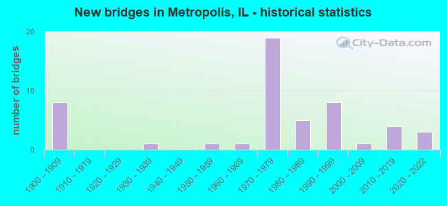
- New bridges - historical statistics
- 81900-1909
- 11930-1939
- 11950-1959
- 11960-1969
- 191970-1979
- 51980-1989
- 81990-1999
- 12000-2009
- 42010-2019
- 32020-2022
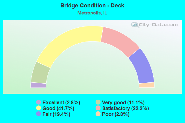
- Bridge Condition - Deck
- 2.8%Excellent
- 11.1%Very good
- 41.7%Good
- 22.2%Satisfactory
- 19.4%Fair
- 2.8%Poor
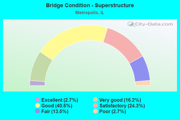
- Bridge Condition - Superstructure
- 2.7%Excellent
- 16.2%Very good
- 40.5%Good
- 24.3%Satisfactory
- 13.5%Fair
- 2.7%Poor
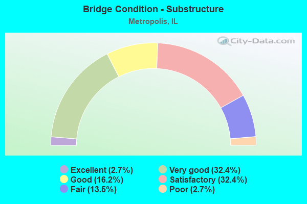
- Bridge Condition - Substructure
- 2.7%Excellent
- 32.4%Very good
- 16.2%Good
- 32.4%Satisfactory
- 13.5%Fair
- 2.7%Poor
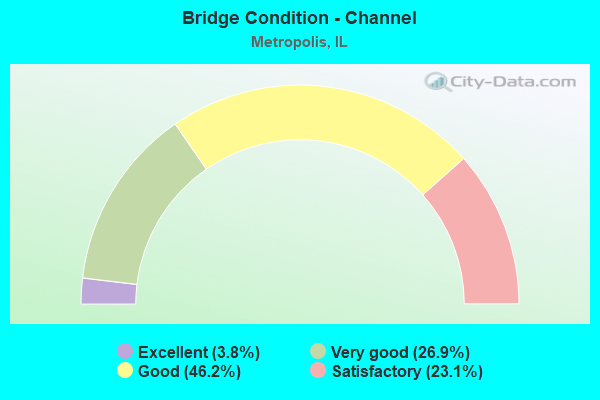
- Bridge Condition - Channel
- 3.8%Excellent
- 26.9%Very good
- 46.2%Good
- 23.1%Satisfactory
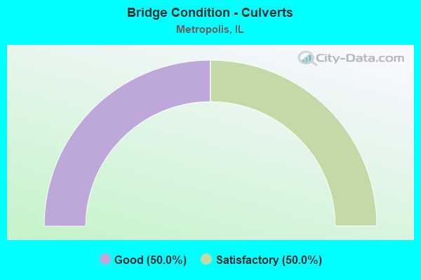
- Bridge Condition - Culverts
- 50.0%Good
- 50.0%Satisfactory
Find on map >> Show street view
Structure Number: 640026, Location: 4 MI N OF US 45 (Lat: 37.216086, Lng: -88.700458), Route carried "under" structure: County highway , Year Built: 1970, Structure Length: 0. m, Average Daily Traffic: 100 (year 2020), Truck Traffic: 9%, Features Intersected: TR 86 MASSAC CR RD, Facility Carried by Structure: I 24 EB
Minimum Vertical Clearance: 4.80m (15.75ft), Kilometerpoint: 9.962, Lanes on structure: 2, Lanes under structure: 2, Material/Design: Steel continuous, Design/Construction: Stringer/Multi-beam, Length of Maximum Span: 15.1m (49.5ft)
Find on map >> Show street view
Structure Number: 640029, Location: 3.5 MI E METROPOLIS (Lat: 37.161361, Lng: -88.682853), Route carried "under" structure: Interstate 24, Year Built: 1970, Structure Length: 0. m, Average Daily Traffic: 28,800 (year 2020), Truck Traffic: 23%, Features Intersected: INTERSTATE 24, Facility Carried by Structure: US 45-FAP 889
Minimum Vertical Clearance: 5.36m (17.59ft), Kilometerpoint: 59.802, Lanes on structure: 4, Lanes under structure: 4, Material/Design: Steel continuous, Design/Construction: Stringer/Multi-beam, Length of Maximum Span: 29.0m (95.1ft)
Find on map >> Show street view
Structure Number: 640034, Location: 1.4 MI S OF US 45 (Lat: 37.142997, Lng: -88.683833), Route carried "under" structure: Other road , Year Built: 1970, Structure Length: 0. m, Average Daily Traffic: 125 (year 2020), Truck Traffic: 6%, Features Intersected: OR 4 FT MASSAC ST PK, Facility Carried by Structure: I 24
Minimum Vertical Clearance: 4.55m (14.93ft), Kilometerpoint: 2.253, Lanes on structure: 4, Lanes under structure: 2, Material/Design: Steel continuous, Design/Construction: Stringer/Multi-beam, Length of Maximum Span: 14.3m (46.9ft)
Find on map >> Show street view
Structure Number: 640045, Location: 2 MI N OF US 45 (Lat: 37.191036, Lng: -88.685722), Route carried "under" structure: County highway , Year Built: 2019, Structure Length: 0. m, Average Daily Traffic: 2,000 (year 2020), Truck Traffic: 7%, Features Intersected: COUNTRY CLUB ROAD, Facility Carried by Structure: I-24 EB
Minimum Vertical Clearance: 4.98m (16.34ft), Kilometerpoint: 7.709, Lanes on structure: 2, Lanes under structure: 2, Material/Design: Steel continuous, Design/Construction: Stringer/Multi-beam, Length of Maximum Span: 18.6m (61.0ft)
Find on map >> Show street view
Structure Number: 640046, Location: 2 MI N OF US 45 (Lat: 37.191031, Lng: -88.685317), Route carried "under" structure: County highway , Year Built: 2020, Structure Length: 0. m, Average Daily Traffic: 2,000 (year 2020), Truck Traffic: 7%, Features Intersected: COUNTRY CLUB, Facility Carried by Structure: I-24 WB
Minimum Vertical Clearance: 4.98m (16.34ft), Kilometerpoint: 7.741, Lanes on structure: 2, Lanes under structure: 2, Material/Design: Steel continuous, Design/Construction: Stringer/Multi-beam, Length of Maximum Span: 18.6m (61.0ft)
Find on map >> Show street view
Structure Number: 649903, Location: METROPOLIS (Lat: 37.160175, Lng: -88.736431), Route carried "under" structure: US 45, Year Built: 1962, Structure Length: 0. m, Average Daily Traffic: 7,450 (year 2021), Truck Traffic: 7%, Features Intersected: US 45, Facility Carried by Structure: I.C.G.R.R.
Minimum Vertical Clearance: 4.47m (14.67ft), Kilometerpoint: 16.013, Lanes under structure: 4, Material/Design: Steel, Design/Construction: Girder and Floorbeam System, Length of Maximum Span: 27.1m (88.9ft)
Find on map >> Show street view
Structure Number: 649909, Location: 2 MI. S. ROUND KNOB (Lat: 37.220519, Lng: -88.738692), Route carried "under" structure: County highway , Year Built: 1900, Structure Length: 0. m, Average Daily Traffic: 125 (year 2020), Truck Traffic: 9%, Features Intersected: TR 89, Facility Carried by Structure: ICG RR
Minimum Vertical Clearance: 3.38m (11.09ft), Kilometerpoint: 5.150, Lanes under structure: 2, Material/Design: Steel, Design/Construction: Stringer/Multi-beam, Length of Maximum Span: 9.8m (32.2ft)
Find on map >> Show street view
Structure Number: 649911, Location: 3 MI. N. METROPOLIS (Lat: 37.209453, Lng: -88.738339), Route carried "under" structure: County highway , Year Built: 1900, Structure Length: 0. m, Average Daily Traffic: 10 (year 2020), Truck Traffic: 20%, Features Intersected: TR 105, Facility Carried by Structure: ICG RR
Minimum Vertical Clearance: 3.86m (12.66ft), Kilometerpoint: 0.756, Lanes under structure: 2, Material/Design: Steel, Design/Construction: Stringer/Multi-beam, Length of Maximum Span: 10.1m (33.1ft)
Find on map >> Show street view
Structure Number: 649912, Location: 3 MI. N. METROPOLIS (Lat: 37.209461, Lng: -88.738158), Route carried "under" structure: County highway , Year Built: 1900, Structure Length: 0. m, Average Daily Traffic: 10 (year 2020), Truck Traffic: 20%, Features Intersected: TR 105, Facility Carried by Structure: ICG RR
Minimum Vertical Clearance: 3.86m (12.66ft), Kilometerpoint: 0.772, Lanes under structure: 1, Material/Design: Steel, Design/Construction: Stringer/Multi-beam, Length of Maximum Span: 10.1m (33.1ft)
Find on map >> Show street view
Structure Number: 649914, Location: W. OF METROPOLIS (Lat: 37.157639, Lng: -88.736550), Route carried "under" structure: Other road , Year Built: 1900, Structure Length: 0. m, Average Daily Traffic: 325 (year 2020), Truck Traffic: 15%, Features Intersected: FAU 9765, Facility Carried by Structure: BN RR
Minimum Vertical Clearance: 3.71m (12.17ft), Kilometerpoint: 0.080, Lanes under structure: 1, Material/Design: Concrete, Design/Construction: Slab, Length of Maximum Span: 7.3m (24.0ft)
Find on map >> Show street view
Structure Number: 649915, Location: W. OF METROPOLIS (Lat: 37.157556, Lng: -88.736417), Route carried "under" structure: Other road , Year Built: 1900, Structure Length: 0. m, Average Daily Traffic: 325 (year 2020), Truck Traffic: 15%, Features Intersected: FAU 9765, Facility Carried by Structure: ICG RR
Minimum Vertical Clearance: 3.53m (11.58ft), Kilometerpoint: 0.064, Lanes under structure: 1, Material/Design: Concrete, Design/Construction: Slab, Length of Maximum Span: 6.7m (22.0ft)