Bridge Statistics for Midland, Michigan (MI)
Condition, Traffic, Stress, Structural Evaluation, Project Costs
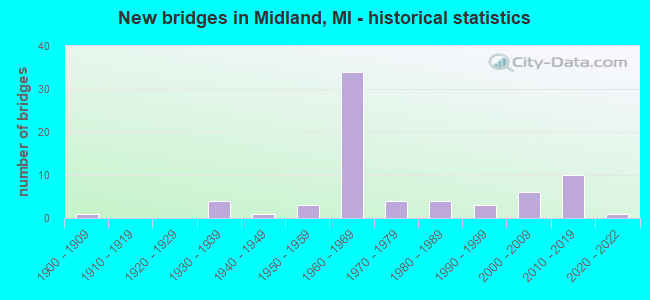
- New bridges - historical statistics
- 11900-1909
- 41930-1939
- 11940-1949
- 31950-1959
- 341960-1969
- 41970-1979
- 41980-1989
- 31990-1999
- 62000-2009
- 102010-2019
- 12020-2022
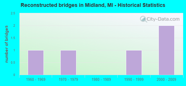
- Reconstructed bridges - Historical Statistics
- 11960-1969
- 11970-1979
- 01980-1989
- 11990-1999
- 22000-2009
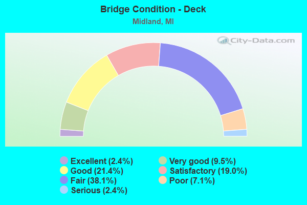
- Bridge Condition - Deck
- 2.4%Excellent
- 9.5%Very good
- 21.4%Good
- 19.0%Satisfactory
- 38.1%Fair
- 7.1%Poor
- 2.4%Serious
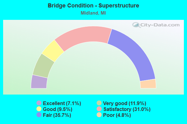
- Bridge Condition - Superstructure
- 7.1%Excellent
- 11.9%Very good
- 9.5%Good
- 31.0%Satisfactory
- 35.7%Fair
- 4.8%Poor
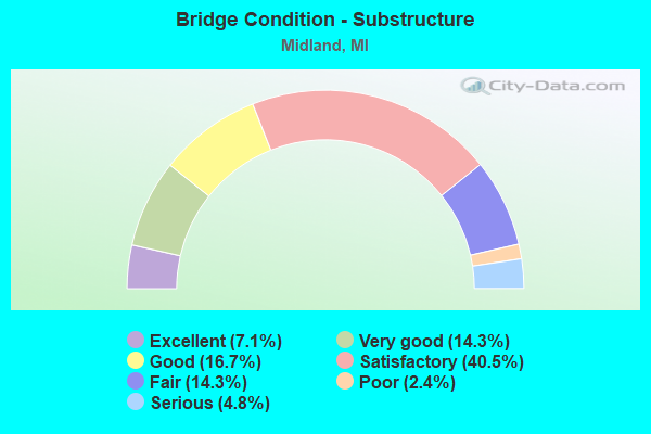
- Bridge Condition - Substructure
- 7.1%Excellent
- 14.3%Very good
- 16.7%Good
- 40.5%Satisfactory
- 14.3%Fair
- 2.4%Poor
- 4.8%Serious
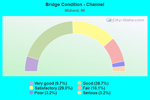
- Bridge Condition - Channel
- 9.7%Very good
- 38.7%Good
- 29.0%Satisfactory
- 16.1%Fair
- 3.2%Poor
- 3.2%Serious
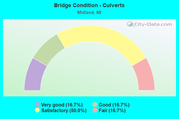
- Bridge Condition - Culverts
- 16.7%Very good
- 16.7%Good
- 50.0%Satisfactory
- 16.7%Fair
Find on map >> Show street view
Structure Number: 7015, Location: IN CITY OF MIDLAND (Lat: 43.610558, Lng: -84.241856), Route carried "on" structure: City street 2015, Year Built: 1968, Status: Open, Structure Length: 20.85m (68.41ft), Average Daily Traffic: 12,000 (year 2014), Truck Traffic: 5%, Average Future Daily Traffic: 21,673 (year 2034), Design Load: HS 20, Features Intersected: TITTABAWASSEE RIVER, Facility Carried by Structure: POSEYVILLE ROAD
Minimum Vertical Clearance: 30.48m (100.00ft), Kilometerpoint: 14.459, Lanes on structure: 4, Lanes under structure: 4, Owner: City or Municipal Highway Agency, Approaching Roadway Width: 15.8m (51.8ft), Skew: 21 degrees, Material/Design: Steel, Design/Construction: Stringer/Multi-beam, Number Of Spans In Main Unit: 8, Length of Maximum Span: 27.4m (89.9ft), Curb-To-Curb Width: 17.1m (56.1ft), Out-to-Out Width: 19.2m (63.0ft)
Condition: Deck: Satisfactory, Superstructure: Satisfactory, Substructure: Satisfactory, Channel: Good, Operating Rating: 91.0 metric tons, Method Used To Determine Operating Rating: Load Factor (LF) rating reported by rating factor (RF) method using MS18 loading, Inventory Rating: 54.8 metric tons, Method Used To Determine Inventory Rating: Load Factor (LF) rating reported by rating factor (RF) method using MS18 loading, Structural Evaluation: Equal to present minimum criteria, Deck Geometry: Somewhat better than minimum adequacy, Underclear: Equal to present minimum criteria, Waterway Adequacy: Equal to present minimum criteria, Approach Roadway Alignment: Better than present minimum criteria, Designated Inspection Frequency: Every 24 months, Underwater Inspection Frequency: Every 60 months, Inspection Date: July 2020, Underwater Inspection Date: September 2017, Deck Structure Type: Concrete Cast-file-Place, Wearing Surface/Protective System: Wearing Surface: Epoxy Overlay
Find on map >> Show street view
Structure Number: 7016, Location: IN CITY OF MIDLAND (Lat: 43.626764, Lng: -84.252994), Route carried "on" structure: City street , Year Built: 2016, Status: Open, Structure Length: 0.91m (2.99ft), Average Daily Traffic: 4,000 (year 1990), Average Future Daily Traffic: 5,000 (year 2007), Design Load: HS 20+Mod, Features Intersected: SNAKE CREEK, Facility Carried by Structure: W ST ANDREWS ROAD
Minimum Vertical Clearance: 30.48m (100.00ft), Kilometerpoint: 0.344, Lanes on structure: 2, Owner: City or Municipal Highway Agency, Approaching Roadway Width: 11.0m (36.1ft), Skew: 4 degrees, Material/Design: Concrete, Design/Construction: Culvert, Number Of Spans In Main Unit: 1, Length of Maximum Span: 8.3m (27.2ft), Curb or Sidewalk Widths: Left: 3.6m (11.8ft), Right: 3.8m (12.5ft), Curb-To-Curb Width: 11.0m (36.1ft), Out-to-Out Width: 16.8m (55.1ft)
Condition: Channel: Very good, Culverts: Very good, Operating Rating: 67.1 metric tons, Method Used To Determine Operating Rating: Load and Resistance Factor Rating (LRFR) rating reported by rating factor(RF) method using HL-93 loadings, Inventory Rating: 51.8 metric tons, Method Used To Determine Inventory Rating: Load and Resistance Factor Rating (LRFR) rating reported by rating factor(RF) method using HL-93 loadings, Structural Evaluation: Equal to present desirable criteria, Deck Geometry: Somewhat better than minimum adequacy, Waterway Adequacy: Meets minimum limits, Approach Roadway Alignment: Equal to present minimum criteria, Designated Inspection Frequency: Every 24 months, Inspection Date: July 2020, Wearing Surface/Protective System: Wearing Surface: Bituminous, Membrane: Preformed Fabric
Find on map >> Show street view
Structure Number: 7018, Location: 0.1 MI W OF STURGEON ROAD (Lat: 43.656550, Lng: -84.268522), Route carried "on" structure: City street , Year Built: 1960, Year Reconstructed: 2014, Status: Open, Structure Length: 1.37m (4.49ft), Average Daily Traffic: 3,911 (year 2013), Truck Traffic: 5%, Average Future Daily Traffic: 5,811 (year 2033), Design Load: HS 20+Mod, Features Intersected: STURGEON CREEK, Facility Carried by Structure: AIRPORT ROAD
Minimum Vertical Clearance: 30.48m (100.00ft), Kilometerpoint: 3.407, Lanes on structure: 2, Owner: City or Municipal Highway Agency, Approaching Roadway Width: 12.2m (40.0ft), Material/Design: Prestressed concrete, Design/Construction: Stringer/Multi-beam, Number Of Spans In Main Unit: 1, Length of Maximum Span: 12.9m (42.3ft), Curb-To-Curb Width: 12.2m (40.0ft), Out-to-Out Width: 12.9m (42.3ft)
Condition: Deck: Satisfactory, Superstructure: Very good, Substructure: Good, Channel: Satisfactory, Operating Rating: 84.2 metric tons, Method Used To Determine Operating Rating: Load and Resistance Factor Rating (LRFR) rating reported by rating factor(RF) method using HL-93 loadings, Inventory Rating: 65.1 metric tons, Method Used To Determine Inventory Rating: Load and Resistance Factor Rating (LRFR) rating reported by rating factor(RF) method using HL-93 loadings, Structural Evaluation: Better than present minimum criteria, Deck Geometry: Equal to present minimum criteria, Waterway Adequacy: Equal to present desirable criteria, Approach Roadway Alignment: Equal to present minimum criteria, Designated Inspection Frequency: Every 24 months, Inspection Date: July 2020, Deck Structure Type: Concrete Cast-file-Place, Wearing Surface/Protective System: Wearing Surface: Monolithic Concrete, Deck Protection: Epoxy Coated Reinforcing
Find on map >> Show street view
Structure Number: 7019, Location: IN CITY OF MIDLAND (Lat: 43.617508, Lng: -84.252292), Route carried "on" structure: City street , Year Built: 1900, Year Reconstructed: 2014, Status: Closed, Structure Length: 4.29m (14.07ft), Average Daily Traffic: 4,550 (year 1985), Average Future Daily Traffic: 10,250 (year 2016), Design Load: H 10, Features Intersected: TITTABAWASSEE RIVER, Facility Carried by Structure: CURRIE PARKWAY
Minimum Vertical Clearance: 2.95m (9.68ft), Kilometerpoint: 1.558, Lanes on structure: 1, Owner: City or Municipal Highway Agency, Approaching Roadway Width: 11.0m (36.1ft), Material/Design: Steel, Design/Construction: Truss - Thru, Number Of Spans In Main Unit: 1, Length of Maximum Span: 42.9m (140.7ft), Curb or Sidewalk Widths: Left: 0.0m, Right: 1.2m (3.9ft), Curb-To-Curb Width: 4.3m (14.1ft), Out-to-Out Width: 4.6m (15.1ft)
Condition: Deck: Good, Superstructure: Fair, Substructure: Fair, Channel: Satisfactory, Operating Rating: 13.0 metric tons, Method Used To Determine Operating Rating: Load Factor (LF), Inventory Rating: 8.0 metric tons, Method Used To Determine Inventory Rating: Load Factor (LF), Waterway Adequacy: Better than present minimum criteria, Approach Roadway Alignment: High priority of replacement, Bridge Posting: Required (Relationship of Operating Rating to Maximum Legal Load: > 39.9% below), Designated Inspection Frequency: Every 24 months, Critical Feature Inspection Frequency: Every 24 months, Inspection Date: December 2020, Critical Feature Inspection Date: July 2020, Deck Structure Type: Corrugated Steel, Wearing Surface/Protective System: Wearing Surface: Latex Concrete, Deck Protection: Epoxy Coated Reinforcing
Find on map >> Show street view
Structure Number: 7021, Location: IN CITY OF MIDLAND (Lat: 43.639989, Lng: -84.231997), Route carried "on" structure: City street , Year Built: 1979, Status: Open, Structure Length: 0.85m (2.79ft), Average Daily Traffic: 450 (year 1981), Average Future Daily Traffic: 518 (year 2001), Design Load: HS 20+Mod, Features Intersected: MEADOWBROOK DRAIN, Facility Carried by Structure: CRESCENT DRIVE
Minimum Vertical Clearance: 30.48m (100.00ft), Kilometerpoint: 1.210, Lanes on structure: 2, Owner: City or Municipal Highway Agency, Approaching Roadway Width: 8.5m (27.9ft), Material/Design: Concrete, Design/Construction: Culvert, Number Of Spans In Main Unit: 3, Length of Maximum Span: 1.8m (5.9ft), Curb or Sidewalk Widths: Left: 1.2m (3.9ft), Right: 1.2m (3.9ft), Out-to-Out Width: 59.4m (194.9ft)
Condition: Channel: Poor, Culverts: Satisfactory, Operating Rating: 55.0 metric tons, Method Used To Determine Operating Rating: Field evaluation and documented engineering judgment, Inventory Rating: 33.0 metric tons, Method Used To Determine Inventory Rating: Field evaluation and documented engineering judgment, Structural Evaluation: Equal to present minimum criteria, Waterway Adequacy: Better than present minimum criteria, Approach Roadway Alignment: Equal to present desirable criteria, Designated Inspection Frequency: Every 24 months, Inspection Date: July 2020, Wearing Surface/Protective System: Wearing Surface: Bituminous
Find on map >> Show street view
Structure Number: 13938, Location: LARKIN TWP SEC 20/29 (Lat: 43.683694, Lng: -84.252361), Route carried "on" structure: County highway , Year Built: 2020, Status: Open, Structure Length: 1.10m (3.61ft), Average Daily Traffic: 2,317 (year 2018), Truck Traffic: 5%, Average Future Daily Traffic: 4,185 (year 2038), Design Load: Greater than HL93, Features Intersected: NEWELL DRAIN, Facility Carried by Structure: MONROE ROAD
Minimum Vertical Clearance: 30.48m (100.00ft), Kilometerpoint: 1.188, Lanes on structure: 2, Owner: County Highway Agency, Approaching Roadway Width: 10.1m (33.1ft), Material/Design: Prestressed concrete, Design/Construction: Box Beam or Girders - Single/Spread, Number Of Spans In Main Unit: 1, Length of Maximum Span: 8.3m (27.2ft), Curb-To-Curb Width: 10.1m (33.1ft), Out-to-Out Width: 11.0m (36.1ft)
Condition: Deck: Excellent, Superstructure: Excellent, Substructure: Excellent, Channel: Very good, Operating Rating: 67.1 metric tons, Method Used To Determine Operating Rating: Load and Resistance Factor Rating (LRFR) rating reported by rating factor(RF) method using HL-93 loadings, Inventory Rating: 50.2 metric tons, Method Used To Determine Inventory Rating: Load and Resistance Factor Rating (LRFR) rating reported by rating factor(RF) method using HL-93 loadings, Structural Evaluation: Superior to present desirable criteria, Deck Geometry: Meets minimum limits, Waterway Adequacy: Better than present minimum criteria, Approach Roadway Alignment: Better than present minimum criteria, Designated Inspection Frequency: Every 24 months, Inspection Date: June 2020, Deck Structure Type: Concrete Cast-file-Place, Wearing Surface/Protective System: Wearing Surface: Monolithic Concrete, Deck Protection: Epoxy Coated Reinforcing
Find on map >> Show street view
Structure Number: 13939, Location: LARKIN TWP SEC 29/30 (Lat: 43.677139, Lng: -84.267139), Route carried "on" structure: County highway , Year Built: 2019, Status: Open, Structure Length: 0.85m (2.79ft), Average Daily Traffic: 3,328 (year 2018), Truck Traffic: 2%, Average Future Daily Traffic: 4,061 (year 2038), Design Load: Greater than HL93, Features Intersected: NEWELL DRAIN, Facility Carried by Structure: STURGEON AVENUE
Minimum Vertical Clearance: 30.48m (100.00ft), Kilometerpoint: 3.993, Lanes on structure: 2, Owner: County Highway Agency, Approaching Roadway Width: 6.7m (22.0ft), Material/Design: Prestressed concrete, Design/Construction: Box Beam or Girders - Single/Spread, Number Of Spans In Main Unit: 1, Length of Maximum Span: 8.0m (26.2ft), Curb-To-Curb Width: 10.1m (33.1ft), Out-to-Out Width: 11.0m (36.1ft)
Condition: Deck: Very good, Superstructure: Very good, Substructure: Very good, Channel: Good, Operating Rating: 71.6 metric tons, Method Used To Determine Operating Rating: Load and Resistance Factor Rating (LRFR) rating reported by rating factor(RF) method using HL-93 loadings, Inventory Rating: 55.1 metric tons, Method Used To Determine Inventory Rating: Load and Resistance Factor Rating (LRFR) rating reported by rating factor(RF) method using HL-93 loadings, Structural Evaluation: Equal to present desirable criteria, Deck Geometry: Meets minimum limits, Waterway Adequacy: Equal to present desirable criteria, Approach Roadway Alignment: Equal to present desirable criteria, Designated Inspection Frequency: Every 24 months, Inspection Date: August 2021, Deck Structure Type: Concrete Cast-file-Place, Wearing Surface/Protective System: Wearing Surface: Monolithic Concrete, Deck Protection: Epoxy Coated Reinforcing
Find on map >> Show street view
Structure Number: 13963, Location: IN MIDLAND (Lat: 43.613661, Lng: -84.250022), Route carried "on" structure: State highway 20, Year Built: 2019, Status: Open, Structure Length: 22.13m (72.60ft), Average Daily Traffic: 21,358 (year 2015), Truck Traffic: 3%, Average Future Daily Traffic: 29,217 (year 2037), Design Load: Greater than HL93, Features Intersected: TITTABAWASSEE RIVER
Minimum Vertical Clearance: 30.48m (100.00ft), Kilometerpoint: 0.000, Lanes on structure: 2, Lanes under structure: 2, Owner: State Highway Agency, Approaching Roadway Width: 12.8m (42.0ft), Skew: 2 degrees, Material/Design: Steel continuous, Design/Construction: Stringer/Multi-beam, Number Of Spans In Main Unit: 4, Length of Maximum Span: 57.9m (190.0ft), Curb-To-Curb Width: 12.8m (42.0ft), Out-to-Out Width: 13.7m (44.9ft)
Condition: Deck: Very good, Superstructure: Excellent, Substructure: Excellent, Channel: Good, Operating Rating: 44.7 metric tons, Method Used To Determine Operating Rating: Load and Resistance Factor Rating (LRFR) rating reported by rating factor(RF) method using HL-93 loadings, Inventory Rating: 34.3 metric tons, Method Used To Determine Inventory Rating: Load and Resistance Factor Rating (LRFR) rating reported by rating factor(RF) method using HL-93 loadings, Structural Evaluation: Superior to present desirable criteria, Deck Geometry: Equal to present desirable criteria, Waterway Adequacy: Equal to present desirable criteria, Approach Roadway Alignment: Equal to present desirable criteria, Designated Inspection Frequency: Every 24 months, Inspection Date: November 2020, Deck Structure Type: Concrete Cast-file-Place, Wearing Surface/Protective System: Wearing Surface: Monolithic Concrete, Deck Protection: Epoxy Coated Reinforcing
Find on map >> Show street view
Structure Number: 13964, Location: IN MIDLAND (Lat: 43.613753, Lng: -84.250078), Route carried "on" structure: State highway 20, Year Built: 2018, Status: Open, Structure Length: 22.13m (72.60ft), Average Daily Traffic: 21,350 (year 2015), Truck Traffic: 3%, Average Future Daily Traffic: 29,217 (year 2035), Design Load: Greater than HL93, Features Intersected: TITTABAWASSEE RIVER
Minimum Vertical Clearance: 30.48m (100.00ft), Kilometerpoint: 0.000, Lanes on structure: 2, Lanes under structure: 2, Owner: State Highway Agency, Approaching Roadway Width: 12.8m (42.0ft), Skew: 2 degrees, Material/Design: Steel continuous, Design/Construction: Stringer/Multi-beam, Number Of Spans In Main Unit: 4, Length of Maximum Span: 57.9m (190.0ft), Curb-To-Curb Width: 12.8m (42.0ft), Out-to-Out Width: 13.7m (44.9ft)
Condition: Deck: Good, Superstructure: Excellent, Substructure: Excellent, Channel: Good, Operating Rating: 43.4 metric tons, Method Used To Determine Operating Rating: Load and Resistance Factor Rating (LRFR) rating reported by rating factor(RF) method using HL-93 loadings, Inventory Rating: 33.4 metric tons, Method Used To Determine Inventory Rating: Load and Resistance Factor Rating (LRFR) rating reported by rating factor(RF) method using HL-93 loadings, Structural Evaluation: Superior to present desirable criteria, Deck Geometry: Equal to present desirable criteria, Underclear: High priority of corrective action, Waterway Adequacy: Equal to present desirable criteria, Approach Roadway Alignment: Equal to present desirable criteria, Designated Inspection Frequency: Every 24 months, Inspection Date: November 2020, Deck Structure Type: Concrete Cast-file-Place, Wearing Surface/Protective System: Wearing Surface: Monolithic Concrete, Deck Protection: Epoxy Coated Reinforcing
Find on map >> Show street view
Structure Number: 14047, Location: INGERSOLL TWP SEC 8/9 (Lat: 43.546700, Lng: -84.248800), Route carried "on" structure: County highway 5677, Year Built: 2017, Status: Open, Structure Length: 0.73m (2.40ft), Average Daily Traffic: 2,196 (year 2016), Average Future Daily Traffic: 2,957 (year 2037), Design Load: Greater than HL93, Features Intersected: JO DRAIN, Facility Carried by Structure: POSEYVILLE ROAD
Minimum Vertical Clearance: 30.48m (100.00ft), Kilometerpoint: 7.234, Lanes on structure: 2, Owner: County Highway Agency, Approaching Roadway Width: 12.5m (41.0ft), Material/Design: Concrete, Design/Construction: Slab, Number Of Spans In Main Unit: 1, Length of Maximum Span: 6.1m (20.0ft), Curb-To-Curb Width: 10.5m (34.4ft), Out-to-Out Width: 11.0m (36.1ft)
Condition: Deck: Good, Superstructure: Good, Substructure: Very good, Channel: Very good, Operating Rating: 70.0 metric tons, Method Used To Determine Operating Rating: Load and Resistance Factor Rating (LRFR) rating reported by rating factor(RF) method using HL-93 loadings, Inventory Rating: 54.4 metric tons, Method Used To Determine Inventory Rating: Load and Resistance Factor Rating (LRFR) rating reported by rating factor(RF) method using HL-93 loadings, Structural Evaluation: Better than present minimum criteria, Deck Geometry: Somewhat better than minimum adequacy, Waterway Adequacy: Equal to present desirable criteria, Approach Roadway Alignment: Equal to present desirable criteria, Designated Inspection Frequency: Every 24 months, Inspection Date: November 2021, Deck Structure Type: Concrete Precast Panels, Wearing Surface/Protective System: Wearing Surface: Bituminous, Deck Protection: Epoxy Coated Reinforcing
Find on map >> Show street view
Structure Number: 651, Location: 1.0 MI S OF US-10 (Lat: 43.582806, Lng: -84.139425), Route carried "under" structure: State highway 47, Year Built: 1966, Structure Length: 0. m, Average Daily Traffic: 9,774 (year 2007), Truck Traffic: 5%, Features Intersected: M-47, Facility Carried by Structure: SALZBURG RD
Minimum Vertical Clearance: 4.98m (16.34ft), Kilometerpoint: 1.608, Lanes on structure: 2, Lanes under structure: 4, Material/Design: Prestressed concrete, Design/Construction: Stringer/Multi-beam, Length of Maximum Span: 18.2m (59.7ft)
Find on map >> Show street view
Structure Number: 658, Location: 0.3 MI E OF MIDLAND COL (Lat: 43.612192, Lng: -84.166222), Route carried "under" structure: County highway 2015, Year Built: 1960, Structure Length: 0. m, Average Daily Traffic: 150 (year 1983), Features Intersected: E PATRICK RD(UNION RD), Facility Carried by Structure: US-10 WB
Minimum Vertical Clearance: 4.50m (14.76ft), Kilometerpoint: 0.151, Lanes on structure: 2, Lanes under structure: 2, Material/Design: Concrete continuous, Design/Construction: Tee Beam, Length of Maximum Span: 15.2m (49.9ft)
Find on map >> Show street view
Structure Number: 659, Location: 0.4 MI E OF MIDLAND COL (Lat: 43.604878, Lng: -84.160783), Route carried "under" structure: US 10, Year Built: 1999, Structure Length: 0. m, Average Daily Traffic: 37,556 (year 2007), Truck Traffic: 6%, Features Intersected: US-10, Facility Carried by Structure: BAY RD
Minimum Vertical Clearance: 5.21m (17.09ft), Kilometerpoint: 0.893, Lanes on structure: 5, Lanes under structure: 4, Material/Design: Prestressed concrete continuous, Design/Construction: Stringer/Multi-beam, Length of Maximum Span: 39.1m (128.3ft)
Find on map >> Show street view
Structure Number: 66, Location: 1.0 MI E OF MIDLAND COL (Lat: 43.597842, Lng: -84.148739), Route carried "under" structure: US 10, Year Built: 1958, Structure Length: 0. m, Average Daily Traffic: 36,602 (year 2007), Truck Traffic: 6%, Features Intersected: US-10, Facility Carried by Structure: FLAJOLE RD
Minimum Vertical Clearance: 4.80m (15.75ft), Kilometerpoint: 2.301, Lanes on structure: 2, Lanes under structure: 4, Material/Design: Concrete continuous, Design/Construction: Tee Beam, Length of Maximum Span: 17.9m (58.7ft)
Find on map >> Show street view
Structure Number: 661, Location: 11.5 MI W OF BAY CITY (Lat: 43.597722, Lng: -84.139050), Route carried "under" structure: US 10, Year Built: 2014, Structure Length: 0. m, Average Daily Traffic: 36,273 (year 2012), Truck Traffic: 5%, Features Intersected: US-10, Facility Carried by Structure: M-47
Minimum Vertical Clearance: 4.80m (15.75ft), Kilometerpoint: 3.084, Lanes on structure: 2, Lanes under structure: 5, Material/Design: Prestressed concrete, Design/Construction: Stringer/Multi-beam, Length of Maximum Span: 29.0m (95.1ft)
Find on map >> Show street view
Structure Number: 663, Location: 1.0 MI W OF FISHERVILLE (Lat: 43.597575, Lng: -84.128872), Route carried "under" structure: US 10, Year Built: 1958, Structure Length: 0. m, Average Daily Traffic: 29,780 (year 2007), Truck Traffic: 7%, Features Intersected: US-10, Facility Carried by Structure: CARTER RD
Minimum Vertical Clearance: 4.80m (15.75ft), Kilometerpoint: 3.904, Lanes on structure: 2, Lanes under structure: 4, Material/Design: Concrete continuous, Design/Construction: Tee Beam, Length of Maximum Span: 17.9m (58.7ft)
Find on map >> Show street view
Structure Number: 6892, Location: IN MIDLAND (SAGINAW RD) (Lat: 43.611356, Lng: -84.210775), Route carried "under" structure: City street 2015, Year Built: 1960, Structure Length: 0. m, Average Daily Traffic: 15,000 (year 1988), Features Intersected: OLD US-10, SAGINAW RD, Facility Carried by Structure: M-20 & US-10 BR EB
Minimum Vertical Clearance: 4.80m (15.75ft), Kilometerpoint: 37.282, Lanes on structure: 2, Lanes under structure: 4, Material/Design: Concrete continuous, Design/Construction: Tee Beam, Length of Maximum Span: 20.6m (67.6ft)
Find on map >> Show street view
Structure Number: 6893, Location: IN MIDLAND (SAGINAW RD) (Lat: 43.611553, Lng: -84.210939), Route carried "under" structure: City street 2015, Year Built: 1960, Structure Length: 0. m, Average Daily Traffic: 15,000 (year 1988), Features Intersected: OLD US-10, SAGINAW RD, Facility Carried by Structure: M-20 & US-10 BR WB
Minimum Vertical Clearance: 4.72m (15.49ft), Kilometerpoint: 37.256, Lanes on structure: 2, Lanes under structure: 2, Material/Design: Concrete continuous, Design/Construction: Tee Beam, Length of Maximum Span: 20.6m (67.6ft)
Find on map >> Show street view
Structure Number: 6894, Location: IN MIDLAND WALDO RD M-20 (Lat: 43.611289, Lng: -84.187425), Route carried "under" structure: City street 2015, Year Built: 1960, Structure Length: 0. m, Average Daily Traffic: 4,600 (year 1988), Features Intersected: WALDO RD, Facility Carried by Structure: M-20 & US-10 BR EB
Minimum Vertical Clearance: 5.16m (16.93ft), Kilometerpoint: 3.908, Lanes on structure: 3, Lanes under structure: 4, Material/Design: Concrete continuous, Design/Construction: Tee Beam, Length of Maximum Span: 17.4m (57.1ft)
Find on map >> Show street view
Structure Number: 6895, Location: IN MIDLAND WALDO RD M-20 (Lat: 43.611494, Lng: -84.187425), Route carried "under" structure: City street 2015, Year Built: 1960, Structure Length: 0. m, Average Daily Traffic: 4,600 (year 1988), Features Intersected: WALDO RD, Facility Carried by Structure: M-20 & US-10 BR WB
Minimum Vertical Clearance: 4.88m (16.01ft), Kilometerpoint: 3.930, Lanes on structure: 2, Lanes under structure: 4, Material/Design: Concrete continuous, Design/Construction: Tee Beam, Length of Maximum Span: 17.4m (57.1ft)
Find on map >> Show street view
Structure Number: 6896, Location: IN MIDLAND M-20 WB, US-10 (Lat: 43.611272, Lng: -84.167672), Route carried "under" structure: State highway 20, Year Built: 1960, Structure Length: 0. m, Average Daily Traffic: 15,306 (year 2007), Truck Traffic: 6%, Features Intersected: US-10BR WB & M-20, Facility Carried by Structure: US-10 EB
Minimum Vertical Clearance: 4.93m (16.17ft), Kilometerpoint: 1.597, Lanes on structure: 2, Lanes under structure: 2, Material/Design: Concrete continuous, Design/Construction: Tee Beam, Length of Maximum Span: 17.9m (58.7ft)
Find on map >> Show street view
Structure Number: 6913, Location: 1.7 MI SE OF M-30 (Lat: 43.672417, Lng: -84.339861), Route carried "under" structure: US 10, Year Built: 1961, Structure Length: 0. m, Average Daily Traffic: 19,964 (year 2007), Truck Traffic: 6%, Features Intersected: US-10, Facility Carried by Structure: HOPE RD
Minimum Vertical Clearance: 5.05m (16.57ft), Kilometerpoint: 24.936, Lanes on structure: 2, Lanes under structure: 4, Material/Design: Steel, Design/Construction: Stringer/Multi-beam, Length of Maximum Span: 28.3m (92.8ft)
Find on map >> Show street view
Structure Number: 6914, Location: 3.2 MI W OF US-10 BR (Lat: 43.656433, Lng: -84.310006), Route carried "under" structure: US 10, Year Built: 1960, Structure Length: 0. m, Average Daily Traffic: 19,964 (year 2007), Truck Traffic: 6%, Features Intersected: US-10, Facility Carried by Structure: STARK RD
Minimum Vertical Clearance: 5.59m (18.34ft), Kilometerpoint: 27.965, Lanes on structure: 2, Lanes under structure: 4, Material/Design: Concrete continuous, Design/Construction: Tee Beam, Length of Maximum Span: 17.9m (58.7ft)
Find on map >> Show street view
Structure Number: 6915, Location: 1.0 MI W OF US-10 BR (Lat: 43.656006, Lng: -84.267086), Route carried "under" structure: US 10, Year Built: 1960, Structure Length: 0. m, Average Daily Traffic: 19,128 (year 2007), Truck Traffic: 6%, Features Intersected: US-10, Facility Carried by Structure: STURGEON RD
Minimum Vertical Clearance: 5.28m (17.32ft), Kilometerpoint: 31.427, Lanes on structure: 2, Lanes under structure: 4, Material/Design: Concrete continuous, Design/Construction: Tee Beam, Length of Maximum Span: 17.9m (58.7ft)
Find on map >> Show street view
Structure Number: 6916, Location: @ US-10 BR EASTMAN RD (Lat: 43.655936, Lng: -84.247128), Route carried "under" structure: Business US 10, Year Built: 2001, Structure Length: 0. m, Average Daily Traffic: 18,000 (year 2013), Truck Traffic: 2%, Features Intersected: US-10BR
Minimum Vertical Clearance: 5.36m (17.59ft), Kilometerpoint: 12.705, Lanes on structure: 2, Lanes under structure: 7, Material/Design: Steel, Design/Construction: Stringer/Multi-beam, Length of Maximum Span: 33.4m (109.6ft)
Find on map >> Show street view
Structure Number: 6917, Location: @ US-10 BR EASTMAN RD (Lat: 43.656144, Lng: -84.247122), Route carried "under" structure: Business US 10, Year Built: 2001, Structure Length: 0. m, Average Daily Traffic: 18,000 (year 2013), Truck Traffic: 2%, Features Intersected: US-10BR
Minimum Vertical Clearance: 5.23m (17.16ft), Kilometerpoint: 12.680, Lanes on structure: 3, Lanes under structure: 7, Material/Design: Steel, Design/Construction: Stringer/Multi-beam, Length of Maximum Span: 33.4m (109.6ft)
Find on map >> Show street view
Structure Number: 6918, Location: 0.8 MI E OF US-10 BR (Lat: 43.655817, Lng: -84.227042), Route carried "under" structure: US 10, Year Built: 1960, Structure Length: 0. m, Average Daily Traffic: 16,000 (year 2013), Truck Traffic: 9%, Features Intersected: US-10, Facility Carried by Structure: JEFFERSON RD
Minimum Vertical Clearance: 5.28m (17.32ft), Kilometerpoint: 34.655, Lanes on structure: 3, Lanes under structure: 4, Material/Design: Concrete continuous, Design/Construction: Tee Beam, Length of Maximum Span: 18.0m (59.1ft)
Find on map >> Show street view
Structure Number: 6919, Location: 2.3 MI NW OF BAY CO LINE (Lat: 43.640542, Lng: -84.187119), Route carried "under" structure: US 10, Year Built: 1960, Structure Length: 0. m, Average Daily Traffic: 16,000 (year 2013), Truck Traffic: 9%, Features Intersected: US-10, Facility Carried by Structure: WALDO RD
Minimum Vertical Clearance: 5.56m (18.24ft), Kilometerpoint: 38.585, Lanes on structure: 2, Lanes under structure: 4, Material/Design: Concrete continuous, Design/Construction: Tee Beam, Length of Maximum Span: 36.7m (120.4ft)
Find on map >> Show street view
Structure Number: 692, Location: IN MIDLAND (Lat: 43.626633, Lng: -84.176833), Route carried "under" structure: US 10, Year Built: 1960, Structure Length: 0. m, Average Daily Traffic: 16,000 (year 2013), Truck Traffic: 9%, Features Intersected: US-10, Facility Carried by Structure: ASHMAN RD
Minimum Vertical Clearance: 5.33m (17.49ft), Kilometerpoint: 40.287, Lanes on structure: 4, Lanes under structure: 4, Material/Design: Concrete continuous, Design/Construction: Tee Beam, Length of Maximum Span: 20.1m (65.9ft)
Find on map >> Show street view
Structure Number: 6921, Location: @ BAY CO LINE SECOND ST (Lat: 43.612225, Lng: -84.168086), Route carried "under" structure: City street 2015, Year Built: 1960, Structure Length: 0. m, Average Daily Traffic: 1,725 (year 1988), Features Intersected: PATRICK ST, Facility Carried by Structure: US-10 EB
Minimum Vertical Clearance: 5.31m (17.42ft), Kilometerpoint: 0.000, Lanes on structure: 2, Lanes under structure: 2, Material/Design: Concrete continuous, Design/Construction: Tee Beam, Length of Maximum Span: 15.1m (49.5ft)
Find on map >> Show street view
Structure Number: 7015, Location: IN CITY OF MIDLAND (Lat: 43.610558, Lng: -84.241856), Route carried "under" structure: City street 1141, Year Built: 1968, Structure Length: 0. m, Average Daily Traffic: 500 (year 0000), Features Intersected: TITTABAWASSEE RIVER, Facility Carried by Structure: POSEYVILLE ROAD
Minimum Vertical Clearance: 4.32m (14.17ft), Kilometerpoint: 0.219, Lanes on structure: 4, Lanes under structure: 4, Material/Design: Steel, Design/Construction: Stringer/Multi-beam, Length of Maximum Span: 27.4m (89.9ft)
Find on map >> Show street view
Structure Number: 13963, Location: IN MIDLAND (Lat: 43.613661, Lng: -84.250022), Route carried "under" structure: City street , Year Built: 2019, Structure Length: 0. m, Average Daily Traffic: 19 (year 2012), Features Intersected: TITTABAWASSEE RIVER, Facility Carried by Structure: M-20 EB
Minimum Vertical Clearance: 5.26m (17.26ft), Kilometerpoint: 0.000, Lanes on structure: 2, Lanes under structure: 2, Material/Design: Steel continuous, Design/Construction: Stringer/Multi-beam, Length of Maximum Span: 57.9m (190.0ft)
Find on map >> Show street view
Structure Number: 13964, Location: IN MIDLAND (Lat: 43.613753, Lng: -84.250078), Route carried "under" structure: City street , Year Built: 2018, Structure Length: 0. m, Average Daily Traffic: 22 (year 2012), Features Intersected: TITTABAWASSEE RIVER, Facility Carried by Structure: M-20 WB
Minimum Vertical Clearance: 5.26m (17.26ft), Kilometerpoint: 0.000, Lanes on structure: 2, Lanes under structure: 2, Material/Design: Steel continuous, Design/Construction: Stringer/Multi-beam, Length of Maximum Span: 57.9m (190.0ft)