Bridge Statistics for Midlothian, Texas (TX)
Condition, Traffic, Stress, Structural Evaluation, Project Costs
- National Bridge Inventory (NBI) Statistics
- 132Number of bridges
- 2,283ft / 696mTotal length
- $187,000Total costs
- 1,013,368Total average daily traffic
- 140,022Total average daily truck traffic
- National Bridge Inventory (NBI) Registered Bridges for Midlothian
- No street view available for this location
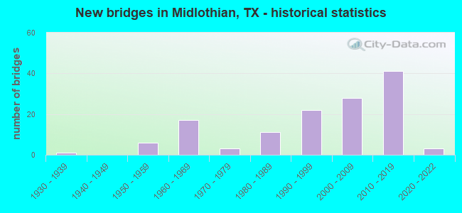
- New bridges - historical statistics
- 11930-1939
- 61950-1959
- 171960-1969
- 31970-1979
- 111980-1989
- 221990-1999
- 282000-2009
- 412010-2019
- 32020-2022
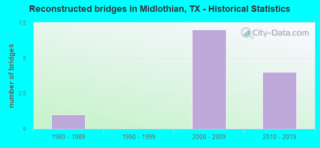
- Reconstructed bridges - Historical Statistics
- 11980-1989
- 01990-1999
- 72000-2009
- 42010-2019
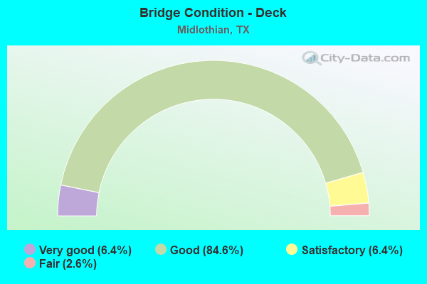
- Bridge Condition - Deck
- 6.4%Very good
- 84.6%Good
- 6.4%Satisfactory
- 2.6%Fair

- Bridge Condition - Superstructure
- 26.9%Very good
- 50.0%Good
- 21.8%Satisfactory
- 1.3%Fair
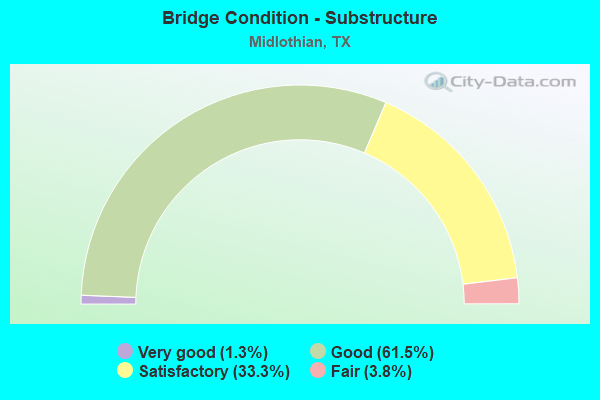
- Bridge Condition - Substructure
- 1.3%Very good
- 61.5%Good
- 33.3%Satisfactory
- 3.8%Fair
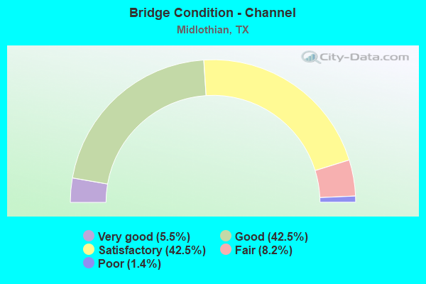
- Bridge Condition - Channel
- 5.5%Very good
- 42.5%Good
- 42.5%Satisfactory
- 8.2%Fair
- 1.4%Poor
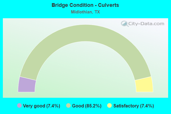
- Bridge Condition - Culverts
- 7.4%Very good
- 85.2%Good
- 7.4%Satisfactory
Find on map >> Show street view
Structure Number: 180710D00380005, Location: 0.90 MI N OF FM 1387 (Lat: 32.501622, Lng: -96.976433), Route carried "on" structure: City street , Year Built: 2004, Status: Open, Structure Length: 0.70m (2.30ft), Average Daily Traffic: 8,938 (year 2019), Truck Traffic: 3%, Average Future Daily Traffic: 12,513 (year 2039), Design Load: HS 20, Features Intersected: DRAW, Facility Carried by Structure: N MIDLOTHIAN PKWY
Minimum Vertical Clearance: 30+ m (98+ ft), Kilometerpoint: 1.448, Lanes on structure: 4, Owner: City or Municipal Highway Agency, Approaching Roadway Width: 14.6m (47.9ft), Skew: 20 degrees, Material/Design: Concrete, Design/Construction: Culvert, Number Of Spans In Main Unit: 3, Length of Maximum Span: 1.8m (5.9ft)
Condition: Channel: Good, Culverts: Good, Operating Rating: 54.4 metric tons, Method Used To Determine Operating Rating: Assigned rating based on Load Factor Design (LFD) reported in metric tons, Inventory Rating: 32.7 metric tons, Method Used To Determine Inventory Rating: Assigned rating based on Load Factor Design (LFD) reported in metric tons, Structural Evaluation: Better than present minimum criteria, Waterway Adequacy: Superior to present desirable criteria, Approach Roadway Alignment: Equal to present desirable criteria, Designated Inspection Frequency: Every 24 months, Inspection Date: June 2021
Find on map >> Show street view
Structure Number: 180710D00381001, Location: 0.50 MI S OF US 287 (Lat: 32.464906, Lng: -96.978547), Route carried "on" structure: City street , Year Built: 2002, Status: Open, Structure Length: 0.98m (3.22ft), Average Daily Traffic: 500 (year 2015), Average Future Daily Traffic: 2,000 (year 2035), Design Load: HS 20, Features Intersected: WAXAHACHIE CREEK TRIB, Facility Carried by Structure: S MIDLOTHIAN PKWY
Minimum Vertical Clearance: 30+ m (98+ ft), Kilometerpoint: 5.168, Lanes on structure: 4, Owner: City or Municipal Highway Agency, Approaching Roadway Width: 14.6m (47.9ft), Skew: 20 degrees, Material/Design: Concrete, Design/Construction: Culvert, Number Of Spans In Main Unit: 3, Length of Maximum Span: 3.0m (9.8ft)
Condition: Channel: Good, Culverts: Good, Operating Rating: 54.4 metric tons, Method Used To Determine Operating Rating: Assigned rating based on Load Factor Design (LFD) reported in metric tons, Inventory Rating: 32.7 metric tons, Method Used To Determine Inventory Rating: Assigned rating based on Load Factor Design (LFD) reported in metric tons, Structural Evaluation: Better than present minimum criteria, Waterway Adequacy: Equal to present minimum criteria, Approach Roadway Alignment: Equal to present desirable criteria, Designated Inspection Frequency: Every 24 months, Inspection Date: December 2020
Find on map >> Show street view
Structure Number: 180710D00395001, Location: 1.0 MI N OF JCT FM 1387 (Lat: 32.501592, Lng: -96.942392), Route carried "on" structure: City street , Year Built: 1991, Status: Open, Structure Length: 2.13m (6.99ft), Average Daily Traffic: 803 (year 2015), Truck Traffic: 2%, Average Future Daily Traffic: 600 (year 2035), Design Load: HS 20, Features Intersected: NORTH PRONG CREEK, Facility Carried by Structure: WALNUT GROVE ROAD
Minimum Vertical Clearance: 30+ m (98+ ft), Kilometerpoint: 5.150, Lanes on structure: 2, Owner: City or Municipal Highway Agency, Approaching Roadway Width: 6.4m (21.0ft), Material/Design: Prestressed concrete, Design/Construction: Stringer/Multi-beam, Number Of Spans In Main Unit: 1, Length of Maximum Span: 21.0m (68.9ft), Curb-To-Curb Width: 8.3m (27.2ft), Out-to-Out Width: 9.1m (29.9ft)
Condition: Deck: Very good, Superstructure: Very good, Substructure: Very good, Channel: Satisfactory, Operating Rating: 54.4 metric tons, Method Used To Determine Operating Rating: Assigned rating based on Load Factor Design (LFD) reported in metric tons, Inventory Rating: 32.7 metric tons, Method Used To Determine Inventory Rating: Assigned rating based on Load Factor Design (LFD) reported in metric tons, Structural Evaluation: Equal to present desirable criteria, Deck Geometry: Somewhat better than minimum adequacy, Waterway Adequacy: Superior to present desirable criteria, Approach Roadway Alignment: Equal to present minimum criteria, Length Of Structure Improvement: 1.74m (5.71ft), Designated Inspection Frequency: Every 24 months, Inspection Date: December 2020, Bridge Improvement Cost: $36,000, Roadway Improvement Cost: $9,000, Total Project Cost: $45,000, Deck Structure Type: Concrete Precast Panels
Find on map >> Show street view
Structure Number: 180710D00400001, Location: .33 MI E/WALNUT GROVE RD (Lat: 32.495433, Lng: -96.936450), Route carried "on" structure: City street , Year Built: 2000, Year Reconstructed: 2018, Status: Open, Structure Length: 2.10m (6.89ft), Average Daily Traffic: 258 (year 2015), Average Future Daily Traffic: 750 (year 2035), Features Intersected: NORTH PRONG CREEK, Facility Carried by Structure: MOCKINGBIRD LANE
Minimum Vertical Clearance: 30+ m (98+ ft), Kilometerpoint: 0.531, Lanes on structure: 2, Owner: City or Municipal Highway Agency, Approaching Roadway Width: 7.3m (24.0ft), Material/Design: Steel, Design/Construction: Stringer/Multi-beam, Number Of Spans In Main Unit: 1, Number Of Approach Spans: 2, Length of Maximum Span: 11.9m (39.0ft), Curb-To-Curb Width: 7.3m (24.0ft), Out-to-Out Width: 7.5m (24.6ft)
Condition: Deck: Good, Superstructure: Satisfactory, Substructure: Satisfactory, Channel: Good, Operating Rating: 24.9 metric tons, Method Used To Determine Operating Rating: Allowable Stress (AS), Inventory Rating: 17.5 metric tons, Method Used To Determine Inventory Rating: Allowable Stress (AS), Structural Evaluation: Somewhat better than minimum adequacy, Deck Geometry: Somewhat better than minimum adequacy, Waterway Adequacy: Better than present minimum criteria, Approach Roadway Alignment: Equal to present desirable criteria, Length Of Structure Improvement: 2.10m (6.89ft), Designated Inspection Frequency: Every 24 months, Inspection Date: December 2020, Bridge Improvement Cost: $3,000, Roadway Improvement Cost: $1,000, Total Project Cost: $4,000, Deck Structure Type: Concrete Cast-file-Place
Find on map >> Show street view
Structure Number: 180710D00405001, Location: 0.25 MI SE OF US 287 (Lat: 32.457272, Lng: -96.942317), Route carried "on" structure: City street , Year Built: 1992, Year Reconstructed: 2018, Status: Open, Structure Length: 2.10m (6.89ft), Average Daily Traffic: 515 (year 2015), Average Future Daily Traffic: 700 (year 2035), Features Intersected: WAXAHACHIE CREEK, Facility Carried by Structure: PLAINVIEW ROAD
Minimum Vertical Clearance: 30+ m (98+ ft), Kilometerpoint: 5.955, Lanes on structure: 2, Owner: City or Municipal Highway Agency, Approaching Roadway Width: 7.3m (24.0ft), Material/Design: Steel continuous, Design/Construction: Stringer/Multi-beam, Number Of Spans In Main Unit: 2, Length of Maximum Span: 11.9m (39.0ft), Curb-To-Curb Width: 7.3m (24.0ft), Out-to-Out Width: 7.5m (24.6ft)
Condition: Deck: Good, Superstructure: Satisfactory, Substructure: Satisfactory, Channel: Satisfactory, Operating Rating: 46.3 metric tons, Method Used To Determine Operating Rating: Allowable Stress (AS), Inventory Rating: 32.7 metric tons, Method Used To Determine Inventory Rating: Allowable Stress (AS), Structural Evaluation: Equal to present minimum criteria, Deck Geometry: Meets minimum limits, Waterway Adequacy: Meets minimum limits, Approach Roadway Alignment: Equal to present desirable criteria, Length Of Structure Improvement: 2.10m (6.89ft), Designated Inspection Frequency: Every 24 months, Inspection Date: December 2020, Bridge Improvement Cost: $2,000, Roadway Improvement Cost: $1,000, Total Project Cost: $3,000, Deck Structure Type: Concrete Cast-file-Place
Find on map >> Show street view
Structure Number: 180710D00410001, Location: 0.04 MI SW OF SHADY GROV (Lat: 32.459578, Lng: -96.950206), Route carried "on" structure: City street , Year Built: 1995, Status: Open, Structure Length: 3.02m (9.91ft), Average Daily Traffic: 50 (year 2015), Truck Traffic: 2%, Average Future Daily Traffic: 500 (year 2035), Features Intersected: WAXAHACHIE CREEK, Facility Carried by Structure: MT ZION ROAD
Minimum Vertical Clearance: 30+ m (98+ ft), Kilometerpoint: 0.064, Lanes on structure: 1, Owner: City or Municipal Highway Agency, Approaching Roadway Width: 6.1m (20.0ft), Material/Design: Steel continuous, Design/Construction: Stringer/Multi-beam, Number Of Spans In Main Unit: 3, Length of Maximum Span: 11.0m (36.1ft), Curb-To-Curb Width: 6.0m (19.7ft), Out-to-Out Width: 6.1m (20.0ft)
Condition: Deck: Satisfactory, Superstructure: Satisfactory, Substructure: Satisfactory, Channel: Satisfactory, Operating Rating: 44.4 metric tons, Method Used To Determine Operating Rating: Allowable Stress (AS), Inventory Rating: 32.7 metric tons, Method Used To Determine Inventory Rating: Allowable Stress (AS), Structural Evaluation: Equal to present minimum criteria, Deck Geometry: Meets minimum limits, Waterway Adequacy: Meets minimum limits, Approach Roadway Alignment: Meets minimum limits, Length Of Structure Improvement: 3.02m (9.91ft), Designated Inspection Frequency: Every 24 months, Inspection Date: December 2020, Deck Structure Type: Concrete Cast-file-Place
Find on map >> Show street view
Structure Number: 180710D00410002, Location: 0.15 MI E OF MIDLOTH PKY (Lat: 32.459781, Lng: -96.975719), Route carried "on" structure: City street , Year Built: 2009, Status: Open, Structure Length: 0.88m (2.89ft), Average Daily Traffic: 628 (year 2015), Average Future Daily Traffic: 1,000 (year 2035), Design Load: HS 20, Features Intersected: WAXAHACHIE CREEK TRIB, Facility Carried by Structure: MT ZION ROAD
Minimum Vertical Clearance: 30+ m (98+ ft), Kilometerpoint: 2.494, Lanes on structure: 4, Owner: City or Municipal Highway Agency, Approaching Roadway Width: 14.6m (47.9ft), Skew: 9 degrees, Material/Design: Concrete, Design/Construction: Culvert, Number Of Spans In Main Unit: 3, Length of Maximum Span: 2.4m (7.9ft)
Condition: Channel: Satisfactory, Culverts: Good, Operating Rating: 54.4 metric tons, Method Used To Determine Operating Rating: Assigned rating based on Load Factor Design (LFD) reported in metric tons, Inventory Rating: 32.7 metric tons, Method Used To Determine Inventory Rating: Assigned rating based on Load Factor Design (LFD) reported in metric tons, Structural Evaluation: Better than present minimum criteria, Waterway Adequacy: Better than present minimum criteria, Approach Roadway Alignment: Equal to present desirable criteria, Length Of Structure Improvement: 0.76m (2.49ft), Designated Inspection Frequency: Every 24 months, Inspection Date: December 2020, Bridge Improvement Cost: $2,000, Roadway Improvement Cost: $1,000, Total Project Cost: $3,000
Find on map >> Show street view
Structure Number: 180710D00410003, Location: 0.1 MI W OF MIDLOTH PKWY (Lat: 32.461722, Lng: -96.981000), Route carried "on" structure: City street , Year Built: 2006, Status: Open, Structure Length: 0.64m (2.10ft), Average Daily Traffic: 500 (year 2015), Average Future Daily Traffic: 1,000 (year 2035), Design Load: HS 20, Features Intersected: WAXAHACHIE CREEK TRIB, Facility Carried by Structure: MOUNT ZION RD
Minimum Vertical Clearance: 30+ m (98+ ft), Kilometerpoint: 2.897, Lanes on structure: 3, Owner: City or Municipal Highway Agency, Approaching Roadway Width: 10.7m (35.1ft), Skew: 1 degrees, Material/Design: Concrete, Design/Construction: Culvert, Number Of Spans In Main Unit: 2, Length of Maximum Span: 3.0m (9.8ft)
Condition: Channel: Good, Culverts: Good, Operating Rating: 54.4 metric tons, Method Used To Determine Operating Rating: Assigned rating based on Load Factor Design (LFD) reported in metric tons, Inventory Rating: 32.7 metric tons, Method Used To Determine Inventory Rating: Assigned rating based on Load Factor Design (LFD) reported in metric tons, Structural Evaluation: Better than present minimum criteria, Waterway Adequacy: Better than present minimum criteria, Approach Roadway Alignment: Equal to present desirable criteria, Designated Inspection Frequency: Every 24 months, Inspection Date: December 2020
Find on map >> Show street view
Structure Number: 180710LQ7918001, Location: 0.26 MI W OF BRIGHTON DR. (Lat: 32.443847, Lng: -96.996147), Route carried "on" structure: City street , Year Built: 2017, Status: Open, Structure Length: 1.80m (5.91ft), Average Daily Traffic: 200 (year 2020), Truck Traffic: 2%, Average Future Daily Traffic: 300 (year 2035), Features Intersected: WAXAHACHIE CR TRIB., Facility Carried by Structure: ROSSVILLE DRIVE
Minimum Vertical Clearance: 30+ m (98+ ft), Kilometerpoint: 0.000, Lanes on structure: 2, Owner: City or Municipal Highway Agency, Approaching Roadway Width: 8.8m (28.9ft), Skew: 1 degrees, Material/Design: Concrete, Design/Construction: Culvert, Number Of Spans In Main Unit: 6, Length of Maximum Span: 2.4m (7.9ft), Curb or Sidewalk Widths: Left: 1.5m (4.9ft), Right: 1.5m (4.9ft), Curb-To-Curb Width: 8.8m (28.9ft), Out-to-Out Width: 15.7m (51.5ft)
Condition: Channel: Good, Culverts: Good, Operating Rating: 32.7 metric tons, Method Used To Determine Operating Rating: Field evaluation and documented engineering judgment, Inventory Rating: 24.5 metric tons, Method Used To Determine Inventory Rating: Field evaluation and documented engineering judgment, Structural Evaluation: Equal to present minimum criteria, Deck Geometry: Equal to present minimum criteria, Waterway Adequacy: Superior to present desirable criteria, Approach Roadway Alignment: Equal to present desirable criteria, Designated Inspection Frequency: Every 24 months, Inspection Date: May 2021
Find on map >> Show street view
Structure Number: 180710LQ7924001, Location: 0.04 MI N OF DOUBLE CR DR (Lat: 32.451208, Lng: -96.991675), Route carried "on" structure: City street , Year Built: 2016, Status: Open, Structure Length: 0.88m (2.89ft), Average Daily Traffic: 100 (year 2020), Average Future Daily Traffic: 200 (year 2035), Features Intersected: WAXAHACHIE CREEK TRIB., Facility Carried by Structure: TIMBERCREST DR
Minimum Vertical Clearance: 30+ m (98+ ft), Kilometerpoint: 0.000, Lanes on structure: 2, Owner: City or Municipal Highway Agency, Approaching Roadway Width: 8.8m (28.9ft), Material/Design: Concrete, Design/Construction: Culvert, Number Of Spans In Main Unit: 3, Length of Maximum Span: 2.4m (7.9ft), Curb or Sidewalk Widths: Left: 1.5m (4.9ft), Right: 1.5m (4.9ft), Curb-To-Curb Width: 8.8m (28.9ft), Out-to-Out Width: 17.3m (56.8ft)
Condition: Channel: Very good, Culverts: Very good, Operating Rating: 32.7 metric tons, Method Used To Determine Operating Rating: Field evaluation and documented engineering judgment, Inventory Rating: 24.5 metric tons, Method Used To Determine Inventory Rating: Field evaluation and documented engineering judgment, Structural Evaluation: Equal to present minimum criteria, Deck Geometry: Better than present minimum criteria, Waterway Adequacy: Better than present minimum criteria, Approach Roadway Alignment: Equal to present desirable criteria, Designated Inspection Frequency: Every 24 months, Inspection Date: May 2021
Find on map >> Show street view
Structure Number: 180710LQ7953001, Location: 0.3 MI S OF BELMONT DR. (Lat: 32.445933, Lng: -96.993506), Route carried "on" structure: City street , Year Built: 2017, Status: Open, Structure Length: 1.46m (4.79ft), Average Daily Traffic: 100 (year 2020), Truck Traffic: 2%, Average Future Daily Traffic: 200 (year 2035), Features Intersected: WAXAHACHIE CREEK TRIB., Facility Carried by Structure: BRIGHTON DRIVE
Minimum Vertical Clearance: 30+ m (98+ ft), Kilometerpoint: 0.000, Lanes on structure: 2, Owner: City or Municipal Highway Agency, Approaching Roadway Width: 8.8m (28.9ft), Material/Design: Concrete, Design/Construction: Culvert, Number Of Spans In Main Unit: 5, Length of Maximum Span: 2.4m (7.9ft), Curb or Sidewalk Widths: Left: 1.5m (4.9ft), Right: 1.5m (4.9ft), Curb-To-Curb Width: 8.8m (28.9ft), Out-to-Out Width: 15.9m (52.2ft)
Condition: Channel: Good, Culverts: Good, Operating Rating: 32.7 metric tons, Method Used To Determine Operating Rating: Field evaluation and documented engineering judgment, Inventory Rating: 24.5 metric tons, Method Used To Determine Inventory Rating: Field evaluation and documented engineering judgment, Structural Evaluation: Equal to present minimum criteria, Deck Geometry: Better than present minimum criteria, Waterway Adequacy: Superior to present desirable criteria, Approach Roadway Alignment: Equal to present desirable criteria, Designated Inspection Frequency: Every 24 months, Inspection Date: May 2021
Find on map >> Show street view
Structure Number: 180710LQ8010001, Location: 0.9 MI S OF US 287 (Lat: 32.450122, Lng: -96.989208), Route carried "on" structure: City street , Year Built: 2017, Status: Open, Structure Length: 0.73m (2.40ft), Average Daily Traffic: 2,000 (year 2020), Truck Traffic: 1%, Average Future Daily Traffic: 3,000 (year 2035), Features Intersected: WAXAHACHIE CREEK TRIB., Facility Carried by Structure: S. 14TH STREET
Minimum Vertical Clearance: 30+ m (98+ ft), Kilometerpoint: 0.000, Lanes on structure: 5, Owner: City or Municipal Highway Agency, Approaching Roadway Width: 14.6m (47.9ft), Skew: 20 degrees, Material/Design: Concrete, Design/Construction: Culvert, Number Of Spans In Main Unit: 2, Length of Maximum Span: 3.0m (9.8ft), Curb or Sidewalk Widths: Left: 2.4m (7.9ft), Right: 0.0m
Condition: Channel: Very good, Culverts: Good, Operating Rating: 32.7 metric tons, Method Used To Determine Operating Rating: Field evaluation and documented engineering judgment, Inventory Rating: 24.5 metric tons, Method Used To Determine Inventory Rating: Field evaluation and documented engineering judgment, Structural Evaluation: Equal to present minimum criteria, Waterway Adequacy: Superior to present desirable criteria, Approach Roadway Alignment: Equal to present desirable criteria, Designated Inspection Frequency: Every 24 months, Inspection Date: May 2021
Find on map >> Show street view
Structure Number: 180710LQ8035001, Location: 0.8 MI SW OF RAILPORT PKY (Lat: 32.429736, Lng: -97.060728), Route carried "on" structure: City street , Year Built: 2012, Status: Open, Structure Length: 3.66m (12.01ft), Average Daily Traffic: 66 (year 2019), Truck Traffic: 3%, Average Future Daily Traffic: 66 (year 2039), Design Load: HL 93, Features Intersected: SOAP CREEK, Facility Carried by Structure: POWER WAY
Minimum Vertical Clearance: 30+ m (98+ ft), Kilometerpoint: 1.287, Lanes on structure: 4, Owner: City or Municipal Highway Agency, Approaching Roadway Width: 14.9m (48.9ft), Material/Design: Prestressed concrete, Design/Construction: Box Beam or Girders - Multiple, Number Of Spans In Main Unit: 3, Length of Maximum Span: 12.2m (40.0ft), Curb-To-Curb Width: 15.0m (49.2ft), Out-to-Out Width: 15.6m (51.2ft)
Condition: Deck: Very good, Superstructure: Very good, Substructure: Good, Channel: Good, Operating Rating: 54.4 metric tons, Method Used To Determine Operating Rating: Assigned ratings based on Load and Resistance Factor Design (LRFD) reported in metric tons, Inventory Rating: 32.7 metric tons, Method Used To Determine Inventory Rating: Assigned ratings based on Load and Resistance Factor Design (LRFD) reported in metric tons, Structural Evaluation: Better than present minimum criteria, Deck Geometry: High priority of replacement, Waterway Adequacy: Superior to present desirable criteria, Approach Roadway Alignment: Equal to present desirable criteria, Designated Inspection Frequency: Every 24 months, Inspection Date: June 2021, Deck Structure Type: Concrete Cast-file-Place
Find on map >> Show street view
Structure Number: 180710LQ8068001, Location: 0.1 MI E OF KOLTER LANE (Lat: 32.416508, Lng: -96.969275), Route carried "on" structure: City street , Year Built: 2005, Status: Open, Structure Length: 0.61m (2.00ft), Average Daily Traffic: 100 (year 2020), Truck Traffic: 1%, Average Future Daily Traffic: 200 (year 2035), Design Load: HS 20, Features Intersected: S PRONG CREEK TRIB., Facility Carried by Structure: KELLEM LYNN DRIVE
Minimum Vertical Clearance: 30+ m (98+ ft), Kilometerpoint: 0.000, Lanes on structure: 1, Owner: City or Municipal Highway Agency, Approaching Roadway Width: 3.7m (12.1ft), Material/Design: Steel, Design/Construction: Stringer/Multi-beam, Number Of Spans In Main Unit: 1, Length of Maximum Span: 6.1m (20.0ft), Curb-To-Curb Width: 5.5m (18.0ft), Out-to-Out Width: 5.5m (18.0ft)
Condition: Deck: Good, Superstructure: Good, Substructure: Satisfactory, Channel: Satisfactory, Operating Rating: 54.4 metric tons, Method Used To Determine Operating Rating: Load Factor (LF), Inventory Rating: 32.7 metric tons, Method Used To Determine Inventory Rating: Load Factor (LF), Structural Evaluation: Equal to present minimum criteria, Deck Geometry: Meets minimum limits, Waterway Adequacy: Superior to present desirable criteria, Approach Roadway Alignment: Equal to present desirable criteria, Designated Inspection Frequency: Every 24 months, Inspection Date: May 2021, Deck Structure Type: Concrete Cast-file-Place
Find on map >> Show street view
Structure Number: 180710LQ8081001, Location: 0.04 N OF DOUBLE CR DR. (Lat: 32.450989, Lng: -96.994328), Route carried "on" structure: City street , Year Built: 2014, Status: Open, Structure Length: 0.79m (2.59ft), Average Daily Traffic: 200 (year 2020), Average Future Daily Traffic: 300 (year 2035), Features Intersected: WAXAHACHIE CR TRIB., Facility Carried by Structure: LAWSON FARMS DRIVE
Minimum Vertical Clearance: 30+ m (98+ ft), Kilometerpoint: 0.000, Lanes on structure: 2, Owner: City or Municipal Highway Agency, Approaching Roadway Width: 10.7m (35.1ft), Material/Design: Concrete, Design/Construction: Culvert, Number Of Spans In Main Unit: 3, Length of Maximum Span: 2.4m (7.9ft), Curb or Sidewalk Widths: Left: 1.2m (3.9ft), Right: 1.2m (3.9ft)
Condition: Channel: Good, Culverts: Good, Operating Rating: 32.7 metric tons, Method Used To Determine Operating Rating: Field evaluation and documented engineering judgment, Inventory Rating: 24.5 metric tons, Method Used To Determine Inventory Rating: Field evaluation and documented engineering judgment, Structural Evaluation: Equal to present minimum criteria, Waterway Adequacy: Better than present minimum criteria, Approach Roadway Alignment: Equal to present desirable criteria, Designated Inspection Frequency: Every 24 months, Inspection Date: May 2021
Find on map >> Show street view
Structure Number: 180710LQ8170001, Location: 0.17 MI SW OF COUNTRY S (Lat: 32.417394, Lng: -96.977717), Route carried "on" structure: City street , Year Built: 2021, Status: Open, Structure Length: 0.84m (2.76ft), Average Daily Traffic: 150 (year 2020), Truck Traffic: 1%, Average Future Daily Traffic: 250 (year 2035), Features Intersected: S PRONG CREEK TRIB., Facility Carried by Structure: POPPIE LANE
Minimum Vertical Clearance: 30+ m (98+ ft), Kilometerpoint: 0.000, Lanes on structure: 2, Owner: City or Municipal Highway Agency, Approaching Roadway Width: 8.5m (27.9ft), Material/Design: Concrete, Design/Construction: Culvert, Number Of Spans In Main Unit: 4, Length of Maximum Span: 1.8m (5.9ft), Curb-To-Curb Width: 9.3m (30.5ft), Out-to-Out Width: 12.0m (39.4ft)
Condition: Channel: Good, Culverts: Very good, Operating Rating: 32.7 metric tons, Method Used To Determine Operating Rating: Field evaluation and documented engineering judgment, Inventory Rating: 24.5 metric tons, Method Used To Determine Inventory Rating: Field evaluation and documented engineering judgment, Structural Evaluation: Equal to present minimum criteria, Deck Geometry: Equal to present minimum criteria, Waterway Adequacy: Better than present minimum criteria, Approach Roadway Alignment: Equal to present desirable criteria, Designated Inspection Frequency: Every 24 months, Inspection Date: May 2021
Find on map >> Show street view
Structure Number: 180710LQ8201001, Location: 1.9 MI S OF US 287 (Lat: 32.435900, Lng: -96.986858), Route carried "on" structure: City street , Year Built: 2018, Status: Open, Structure Length: 0.72m (2.36ft), Average Daily Traffic: 2,000 (year 2020), Truck Traffic: 1%, Average Future Daily Traffic: 3,000 (year 2035), Features Intersected: WAXAHACHIE CREEK TRIB., Facility Carried by Structure: S 14TH STREET
Minimum Vertical Clearance: 30+ m (98+ ft), Kilometerpoint: 0.000, Lanes on structure: 4, Owner: City or Municipal Highway Agency, Approaching Roadway Width: 14.6m (47.9ft), Skew: 24 degrees, Material/Design: Concrete, Design/Construction: Culvert, Number Of Spans In Main Unit: 2, Length of Maximum Span: 2.4m (7.9ft), Curb or Sidewalk Widths: Left: 2.4m (7.9ft), Right: 0.0m
Condition: Channel: Good, Culverts: Good, Operating Rating: 32.7 metric tons, Method Used To Determine Operating Rating: Field evaluation and documented engineering judgment, Inventory Rating: 24.5 metric tons, Method Used To Determine Inventory Rating: Field evaluation and documented engineering judgment, Structural Evaluation: Equal to present minimum criteria, Waterway Adequacy: Better than present minimum criteria, Approach Roadway Alignment: Equal to present desirable criteria, Designated Inspection Frequency: Every 24 months, Inspection Date: May 2021
Find on map >> Show street view
Structure Number: 180710LQ8801001, Location: 0.11 S OF MILLIGAN DR. (Lat: 32.419369, Lng: -96.993753), Route carried "on" structure: City street , Year Built: 2020, Status: Open, Structure Length: 1.54m (5.05ft), Average Daily Traffic: 200 (year 2020), Truck Traffic: 1%, Average Future Daily Traffic: 300 (year 2035), Features Intersected: SOUTH PRONG CREEK, Facility Carried by Structure: BRIANA DRIVE
Minimum Vertical Clearance: 30+ m (98+ ft), Kilometerpoint: 0.000, Lanes on structure: 2, Owner: City or Municipal Highway Agency, Approaching Roadway Width: 8.8m (28.9ft), Skew: 1 degrees, Material/Design: Concrete, Design/Construction: Culvert, Number Of Spans In Main Unit: 4, Length of Maximum Span: 3.0m (9.8ft), Curb or Sidewalk Widths: Left: 1.5m (4.9ft), Right: 1.5m (4.9ft), Curb-To-Curb Width: 8.8m (28.9ft), Out-to-Out Width: 16.2m (53.1ft)
Condition: Channel: Very good, Culverts: Good, Operating Rating: 32.7 metric tons, Method Used To Determine Operating Rating: Field evaluation and documented engineering judgment, Inventory Rating: 24.5 metric tons, Method Used To Determine Inventory Rating: Field evaluation and documented engineering judgment, Structural Evaluation: Equal to present minimum criteria, Deck Geometry: Equal to present minimum criteria, Waterway Adequacy: Better than present minimum criteria, Approach Roadway Alignment: Equal to present desirable criteria, Designated Inspection Frequency: Every 24 months, Inspection Date: May 2021
Find on map >> Show street view
Structure Number: 180710LQ9902001, Location: 0.7 MI S OF MT ZION RD. (Lat: 32.450017, Lng: -96.965914), Route carried "on" structure: City street , Year Built: 2019, Status: Open, Structure Length: 1.22m (4.00ft), Average Daily Traffic: 1,000 (year 2020), Truck Traffic: 1%, Average Future Daily Traffic: 2,000 (year 2035), Design Load: HL 93, Features Intersected: WAXAHACHIE CREEK TRIB., Facility Carried by Structure: LEDGESTONE LANE
Minimum Vertical Clearance: 30+ m (98+ ft), Kilometerpoint: 0.000, Lanes on structure: 2, Owner: City or Municipal Highway Agency, Approaching Roadway Width: 14.0m (45.9ft), Material/Design: Steel, Design/Construction: Culvert, Number Of Spans In Main Unit: 1, Length of Maximum Span: 12.2m (40.0ft), Curb or Sidewalk Widths: Left: 2.6m (8.5ft), Right: 2.6m (8.5ft)
Condition: Channel: Good, Culverts: Good, Operating Rating: 54.4 metric tons, Method Used To Determine Operating Rating: Assigned ratings based on Load and Resistance Factor Design (LRFD) reported in metric tons, Inventory Rating: 32.7 metric tons, Method Used To Determine Inventory Rating: Assigned ratings based on Load and Resistance Factor Design (LRFD) reported in metric tons, Structural Evaluation: Better than present minimum criteria, Waterway Adequacy: Superior to present desirable criteria, Approach Roadway Alignment: Equal to present desirable criteria, Designated Inspection Frequency: Every 24 months, Inspection Date: May 2021
Find on map >> Show street view
Structure Number: 180710LQ9903001, Location: 0.06 MI S OF MOCKINGBIRD (Lat: 32.494886, Lng: -96.925094), Route carried "on" structure: City street , Year Built: 2021, Status: Open, Structure Length: 0.79m (2.59ft), Average Daily Traffic: 100 (year 2021), Truck Traffic: 1%, Average Future Daily Traffic: 300 (year 2035), Design Load: HL 93, Features Intersected: N PRONG CREEK TRIB., Facility Carried by Structure: N HAYES ROAD
Minimum Vertical Clearance: 30+ m (98+ ft), Kilometerpoint: 0.000, Lanes on structure: 2, Owner: City or Municipal Highway Agency, Approaching Roadway Width: 7.3m (24.0ft), Skew: 1 degrees, Material/Design: Concrete, Design/Construction: Culvert, Number Of Spans In Main Unit: 3, Length of Maximum Span: 2.4m (7.9ft), Curb or Sidewalk Widths: Left: 0.0m, Right: 1.5m (4.9ft)
Condition: Channel: Good, Culverts: Good, Operating Rating: 54.4 metric tons, Method Used To Determine Operating Rating: Assigned ratings based on Load and Resistance Factor Design (LRFD) reported in metric tons, Inventory Rating: 32.7 metric tons, Method Used To Determine Inventory Rating: Assigned ratings based on Load and Resistance Factor Design (LRFD) reported in metric tons, Structural Evaluation: Better than present minimum criteria, Waterway Adequacy: Better than present minimum criteria, Approach Roadway Alignment: Equal to present desirable criteria, Designated Inspection Frequency: Every 24 months, Inspection Date: May 2021
Find on map >> Show street view
Structure Number: 180710LZ5294001, Location: 0.7 MI S OF US 287 (Lat: 32.452281, Lng: -96.989225), Route carried "on" structure: City street , Year Built: 2018, Status: Open, Structure Length: 1.13m (3.71ft), Average Daily Traffic: 2,000 (year 2020), Truck Traffic: 1%, Average Future Daily Traffic: 3,000 (year 2035), Features Intersected: WAXAHACHIE CR TRIBUTARY, Facility Carried by Structure: 14TH STREET
Minimum Vertical Clearance: 30+ m (98+ ft), Kilometerpoint: 0.000, Lanes on structure: 4, Owner: City or Municipal Highway Agency, Approaching Roadway Width: 14.6m (47.9ft), Skew: 23 degrees, Material/Design: Concrete, Design/Construction: Culvert, Number Of Spans In Main Unit: 3, Length of Maximum Span: 2.7m (8.9ft), Curb or Sidewalk Widths: Left: 2.7m (8.9ft), Right: 1.5m (4.9ft), Curb-To-Curb Width: 14.6m (47.9ft), Out-to-Out Width: 27.6m (90.6ft)
Condition: Channel: Very good, Culverts: Good, Operating Rating: 32.7 metric tons, Method Used To Determine Operating Rating: Field evaluation and documented engineering judgment, Inventory Rating: 24.5 metric tons, Method Used To Determine Inventory Rating: Field evaluation and documented engineering judgment, Structural Evaluation: Equal to present minimum criteria, Deck Geometry: High priority of replacement, Waterway Adequacy: Better than present minimum criteria, Approach Roadway Alignment: Equal to present desirable criteria, Designated Inspection Frequency: Every 24 months, Inspection Date: May 2021
Find on map >> Show street view
Structure Number: 180710017204207, Location: 0.5 MI E OF US 287 (Lat: 32.482153, Lng: -97.017644), Route carried "under" structure: State highway 287, Year Built: 2010, Structure Length: 0. m, Average Daily Traffic: 4,600 (year 2011), Features Intersected: BUS US 287
Minimum Vertical Clearance: 5.01m (16.44ft), Kilometerpoint: 0.000, Lanes on structure: 2, Lanes under structure: 4, Material/Design: Prestressed concrete, Design/Construction: Stringer/Multi-beam, Length of Maximum Span: 34.1m (111.9ft)
Find on map >> Show street view
Structure Number: 180710017204208, Location: 0.5 MI E OF US 287 (Lat: 32.482161, Lng: -97.018122), Route carried "under" structure: State highway 287, Year Built: 2010, Structure Length: 0. m, Average Daily Traffic: 4,600 (year 2011), Features Intersected: BUS US 287
Minimum Vertical Clearance: 5.01m (16.44ft), Kilometerpoint: 0.000, Lanes on structure: 2, Lanes under structure: 4, Material/Design: Prestressed concrete, Design/Construction: Stringer/Multi-beam, Length of Maximum Span: 34.1m (111.9ft)
Find on map >> Show street view
Structure Number: 18071001720522, Location: 2.0 MI E OF US 67 (Lat: 32.470897, Lng: -96.976431), Route carried "under" structure: US 287, Year Built: 2010, Structure Length: 0. m, Average Daily Traffic: 19,160 (year 2013), Truck Traffic: 12%, Features Intersected: US 287, Facility Carried by Structure: MIDLOTHIAN PKWY NB
Minimum Vertical Clearance: 6.22m (20.41ft), Kilometerpoint: 28.046, Lanes on structure: 2, Lanes under structure: 4, Material/Design: Prestressed concrete, Design/Construction: Stringer/Multi-beam, Length of Maximum Span: 36.0m (118.1ft)
Find on map >> Show street view
Structure Number: 180710017205221, Location: 2.0 MI E OF US 67 (Lat: 32.470772, Lng: -96.976642), Route carried "under" structure: US 287, Year Built: 2010, Structure Length: 0. m, Average Daily Traffic: 19,160 (year 2013), Truck Traffic: 12%, Features Intersected: US 287, Facility Carried by Structure: MIDLOTHIAN PKWY SB
Minimum Vertical Clearance: 5.01m (16.44ft), Kilometerpoint: 28.046, Lanes on structure: 2, Lanes under structure: 4, Material/Design: Prestressed concrete, Design/Construction: Stringer/Multi-beam, Length of Maximum Span: 36.0m (118.1ft)
Find on map >> Show street view
Structure Number: 180710017213212, Location: 1.0 MI SE OF US 67 (Lat: 32.463258, Lng: -96.993600), Route carried "under" structure: US 287, Year Built: 2010, Structure Length: 0. m, Average Daily Traffic: 19,160 (year 2013), Truck Traffic: 12%, Features Intersected: US 287, Facility Carried by Structure: FM 663
Minimum Vertical Clearance: 5.03m (16.50ft), Kilometerpoint: 3.492, Lanes on structure: 6, Lanes under structure: 4, Material/Design: Prestressed concrete, Design/Construction: Stringer/Multi-beam, Length of Maximum Span: 32.0m (105.0ft)
Find on map >> Show street view
Structure Number: 180710017213213, Location: 0.6 MI SW OF US 67 (Lat: 32.465992, Lng: -97.003503), Route carried "under" structure: US 287, Year Built: 2010, Structure Length: 0. m, Average Daily Traffic: 19,160 (year 2013), Truck Traffic: 12%, Features Intersected: US 287, Facility Carried by Structure: WALTER STEPHENSON
Minimum Vertical Clearance: 5.41m (17.75ft), Kilometerpoint: 27.755, Lanes on structure: 2, Lanes under structure: 4, Material/Design: Prestressed concrete, Design/Construction: Stringer/Multi-beam, Length of Maximum Span: 33.0m (108.3ft)
Find on map >> Show street view
Structure Number: 180710017213219, Location: 1.4 MI SE OF US 67 (Lat: 32.463225, Lng: -96.988903), Route carried "under" structure: US 287, Year Built: 2010, Structure Length: 0. m, Average Daily Traffic: 19,160 (year 2013), Truck Traffic: 12%, Features Intersected: US 287, Facility Carried by Structure: 14TH STREET
Minimum Vertical Clearance: 5.18m (16.99ft), Kilometerpoint: 35.151, Lanes on structure: 4, Lanes under structure: 4, Material/Design: Prestressed concrete, Design/Construction: Stringer/Multi-beam, Length of Maximum Span: 31.0m (101.7ft)
Find on map >> Show street view
Structure Number: 180710026002021, Location: 1.60 MI SW OF MIDLOTHIAN (Lat: 32.466603, Lng: -97.028156), Route carried "under" structure: City street , Year Built: 1969, Structure Length: 0. m, Average Daily Traffic: 1,000 (year 2011), Truck Traffic: 10%, Features Intersected: WARD RD, Facility Carried by Structure: US 67 NB
Minimum Vertical Clearance: 4.72m (15.49ft), Kilometerpoint: 0.000, Lanes on structure: 2, Lanes under structure: 2, Material/Design: Prestressed concrete, Design/Construction: Stringer/Multi-beam, Length of Maximum Span: 15.2m (49.9ft)
Find on map >> Show street view
Structure Number: 18071002600203, Location: 1.60 MI SW OF MIDLOTHIAN (Lat: 32.466736, Lng: -97.028297), Route carried "under" structure: City street , Year Built: 1980, Structure Length: 0. m, Average Daily Traffic: 1,000 (year 2011), Truck Traffic: 10%, Features Intersected: WARD RD, Facility Carried by Structure: US 67 SBML
Minimum Vertical Clearance: 5.08m (16.67ft), Kilometerpoint: 0.000, Lanes on structure: 2, Lanes under structure: 2, Material/Design: Prestressed concrete, Design/Construction: Stringer/Multi-beam, Length of Maximum Span: 15.2m (49.9ft)
Find on map >> Show street view
Structure Number: 180710026002214, Location: 1.45 MI W OF FM 663 (Lat: 32.476622, Lng: -97.011222), Route carried "under" structure: State highway 67, Year Built: 2010, Structure Length: 0. m, Average Daily Traffic: 15,000 (year 2011), Truck Traffic: 17%, Features Intersected: US 67 BUS 67 BNSF RR, Facility Carried by Structure: US 287 NB
Minimum Vertical Clearance: 6.45m (21.16ft), Kilometerpoint: 0.000, Lanes on structure: 2, Lanes under structure: 10, Material/Design: Prestressed concrete, Design/Construction: Stringer/Multi-beam, Length of Maximum Span: 34.1m (111.9ft)
Find on map >> Show street view
Structure Number: 180710026002215, Location: 1.45 MI NW OF FM 663 (Lat: 32.476308, Lng: -97.011400), Route carried "under" structure: State highway 67, Year Built: 2010, Structure Length: 0. m, Average Daily Traffic: 15,000 (year 2011), Truck Traffic: 17%, Features Intersected: US 67 BUS 67 BNSF RR, Facility Carried by Structure: US 287 SB
Minimum Vertical Clearance: 6.33m (20.77ft), Kilometerpoint: 0.000, Lanes on structure: 3, Lanes under structure: 11, Material/Design: Prestressed concrete, Design/Construction: Stringer/Multi-beam, Length of Maximum Span: 34.1m (111.9ft)
Find on map >> Show street view
Structure Number: 180710026002217, Location: 0.5 MI S OF BUS US 287 (Lat: 32.474269, Lng: -97.011950), Route carried "under" structure: US 67, Year Built: 2010, Structure Length: 0. m, Average Daily Traffic: 4,000 (year 2011), Features Intersected: US 67, Facility Carried by Structure: RAMP J
Minimum Vertical Clearance: 5.08m (16.67ft), Kilometerpoint: 11.454, Lanes on structure: 1, Lanes under structure: 5, Material/Design: Prestressed concrete, Design/Construction: Stringer/Multi-beam, Length of Maximum Span: 36.0m (118.1ft)
Find on map >> Show street view
Structure Number: 180710026002359, Location: 3.25 MI SW OF US 287 (Lat: 32.452536, Lng: -97.058967), Route carried "under" structure: City street , Year Built: 2013, Structure Length: 0. m, Average Daily Traffic: 500 (year 2013), Truck Traffic: 30%, Features Intersected: RAILPORT PKWY, Facility Carried by Structure: US 67 NB
Minimum Vertical Clearance: 5.21m (17.09ft), Kilometerpoint: 2.173, Lanes on structure: 2, Lanes under structure: 4, Material/Design: Prestressed concrete, Design/Construction: Stringer/Multi-beam, Length of Maximum Span: 15.9m (52.2ft)
Find on map >> Show street view
Structure Number: 18071002600236, Location: 3.25 MI SW OF US 287 (Lat: 32.452783, Lng: -97.059117), Route carried "under" structure: City street , Year Built: 2013, Structure Length: 0. m, Average Daily Traffic: 500 (year 2013), Truck Traffic: 30%, Features Intersected: RAILPORT PKWY, Facility Carried by Structure: US 67 SB
Minimum Vertical Clearance: 5.26m (17.26ft), Kilometerpoint: 2.173, Lanes on structure: 2, Lanes under structure: 4, Material/Design: Prestressed concrete, Design/Construction: Stringer/Multi-beam, Length of Maximum Span: 15.9m (52.2ft)
Find on map >> Show street view
Structure Number: 180710026101035, Location: 0.80 MI NE OF US 287 (Lat: 32.490883, Lng: -97.003258), Route carried "under" structure: City street , Year Built: 1969, Structure Length: 0. m, Average Daily Traffic: 1,000 (year 2011), Truck Traffic: 10%, Features Intersected: OVERLOOK DR, Facility Carried by Structure: US 67 NB
Minimum Vertical Clearance: 5.05m (16.57ft), Kilometerpoint: 8.045, Lanes on structure: 2, Lanes under structure: 2, Material/Design: Prestressed concrete, Design/Construction: Stringer/Multi-beam, Length of Maximum Span: 19.8m (65.0ft)
Find on map >> Show street view
Structure Number: 180710026101038, Location: 0.7 MI N OF US 287 (Lat: 32.495342, Lng: -96.993506), Route carried "under" structure: US 67, Year Built: 1969, Structure Length: 0. m, Average Daily Traffic: 26,840 (year 2013), Truck Traffic: 14%, Features Intersected: US 67, Facility Carried by Structure: LOOP 489
Minimum Vertical Clearance: 5.11m (16.77ft), Kilometerpoint: 7.038, Lanes on structure: 2, Lanes under structure: 4, Material/Design: Prestressed concrete, Design/Construction: Stringer/Multi-beam, Length of Maximum Span: 24.4m (80.1ft)
Find on map >> Show street view
Structure Number: 180710026101062, Location: 0.80 MI NE OF US 287 (Lat: 32.491064, Lng: -97.003403), Route carried "under" structure: City street , Year Built: 1980, Structure Length: 0. m, Average Daily Traffic: 1,000 (year 2011), Truck Traffic: 10%, Features Intersected: OVERLOOK DR, Facility Carried by Structure: US 67 SB
Minimum Vertical Clearance: 5.79m (19.00ft), Kilometerpoint: 8.034, Lanes on structure: 2, Lanes under structure: 2, Material/Design: Prestressed concrete, Design/Construction: Stringer/Multi-beam, Length of Maximum Span: 19.8m (65.0ft)
Find on map >> Show street view
Structure Number: 180710026101083, Location: 2.60 MI N OF US 287 (Lat: 32.510692, Lng: -96.983978), Route carried "under" structure: Alternate City street , Year Built: 1993, Structure Length: 0. m, Average Daily Traffic: 500 (year 2010), Features Intersected: DOVE LN, Facility Carried by Structure: US 67 SB
Minimum Vertical Clearance: 5.39m (17.68ft), Kilometerpoint: 3.449, Lanes on structure: 2, Lanes under structure: 3, Material/Design: Prestressed concrete, Design/Construction: Stringer/Multi-beam, Length of Maximum Span: 29.0m (95.1ft)
Find on map >> Show street view
Structure Number: 180710026101084, Location: 2.60 MI N OF US 287 (Lat: 32.510694, Lng: -96.983850), Route carried "under" structure: Alternate City street , Year Built: 1993, Structure Length: 0. m, Average Daily Traffic: 500 (year 2011), Features Intersected: DOVE LN, Facility Carried by Structure: US 67 NB
Minimum Vertical Clearance: 5.21m (17.09ft), Kilometerpoint: 3.500, Lanes on structure: 2, Lanes under structure: 3, Material/Design: Prestressed concrete, Design/Construction: Stringer/Multi-beam, Length of Maximum Span: 29.0m (95.1ft)
Find on map >> Show street view
Structure Number: 180710026101085, Location: 3.60 MI N OF US 287 (Lat: 32.518083, Lng: -96.981383), Route carried "under" structure: US 67, Year Built: 1993, Structure Length: 0. m, Average Daily Traffic: 20,000 (year 2011), Truck Traffic: 17%, Features Intersected: US 67, Facility Carried by Structure: GIFCO RD
Minimum Vertical Clearance: 5.61m (18.41ft), Kilometerpoint: 56.671, Lanes on structure: 2, Lanes under structure: 4, Material/Design: Prestressed concrete, Design/Construction: Stringer/Multi-beam, Length of Maximum Span: 26.2m (86.0ft)
Find on map >> Show street view
Structure Number: 180710026101086, Location: 4.65 MI N OF US 287 (Lat: 32.532819, Lng: -96.976106), Route carried "under" structure: Alternate City street , Year Built: 1993, Structure Length: 0. m, Average Daily Traffic: 1,472 (year 2011), Features Intersected: SHILOH RD, Facility Carried by Structure: US 67 SB
Minimum Vertical Clearance: 5.23m (17.16ft), Kilometerpoint: 7.588, Lanes on structure: 2, Lanes under structure: 2, Material/Design: Prestressed concrete, Design/Construction: Stringer/Multi-beam, Length of Maximum Span: 27.4m (89.9ft)
Find on map >> Show street view
Structure Number: 180710026101087, Location: 4.65 MI N OF US 287 (Lat: 32.532833, Lng: -96.975964), Route carried "under" structure: Alternate City street , Year Built: 1993, Structure Length: 0. m, Average Daily Traffic: 1,473 (year 2011), Features Intersected: SHILOH RD, Facility Carried by Structure: US 67 NB
Minimum Vertical Clearance: 5.77m (18.93ft), Kilometerpoint: 7.588, Lanes on structure: 2, Lanes under structure: 2, Material/Design: Prestressed concrete, Design/Construction: Stringer/Multi-beam, Length of Maximum Span: 27.4m (89.9ft)
Find on map >> Show street view
Structure Number: 180710026101156, Location: US 67 AT US 287 BUS (Lat: 32.482175, Lng: -97.009325), Route carried "under" structure: State highway 287, Year Built: 1969, Structure Length: 0. m, Average Daily Traffic: 17,400 (year 2011), Truck Traffic: 16%, Features Intersected: US 287 BUS, Facility Carried by Structure: US 67 NB
Minimum Vertical Clearance: 5.49m (18.01ft), Kilometerpoint: 10.332, Lanes on structure: 2, Lanes under structure: 6, Material/Design: Steel continuous, Design/Construction: Stringer/Multi-beam, Length of Maximum Span: 30.5m (100.1ft)
Find on map >> Show street view
Structure Number: 180710026101167, Location: US 67 AT US 287 BUS (Lat: 32.482175, Lng: -97.009594), Route carried "under" structure: State highway 287, Year Built: 1980, Structure Length: 0. m, Average Daily Traffic: 17,400 (year 2011), Truck Traffic: 16%, Features Intersected: US 287 BUS, Facility Carried by Structure: US 67 SB
Minimum Vertical Clearance: 5.97m (19.59ft), Kilometerpoint: 10.308, Lanes on structure: 2, Lanes under structure: 6, Material/Design: Prestressed concrete, Design/Construction: Stringer/Multi-beam, Length of Maximum Span: 30.5m (100.1ft)
Find on map >> Show street view
Structure Number: 180710026101225, Location: US 67 AT US 287 BUS (Lat: 32.482128, Lng: -97.009511), Route carried "under" structure: State highway 287, Year Built: 2007, Structure Length: 0. m, Average Daily Traffic: 17,400 (year 2011), Truck Traffic: 16%, Features Intersected: US 287 BUS, Facility Carried by Structure: RAMP L (TO US67NB)
Minimum Vertical Clearance: 5.26m (17.26ft), Kilometerpoint: 10.332, Lanes on structure: 1, Lanes under structure: 7, Material/Design: Steel continuous, Design/Construction: Stringer/Multi-beam, Length of Maximum Span: 30.5m (100.1ft)
Find on map >> Show street view
Structure Number: 180710026101226, Location: US 67 NBFR AT UP RR (Lat: 32.492642, Lng: -96.998614), Route carried "under" structure: Other road , Year Built: 2018, Structure Length: 0. m, Features Intersected: UPRR, Facility Carried by Structure: US 67 NBFR
Minimum Vertical Clearance: 7.19m (23.59ft), Kilometerpoint: 0.000, Lanes on structure: 2, Material/Design: Prestressed concrete, Design/Construction: Stringer/Multi-beam, Length of Maximum Span: 35.1m (115.2ft)
Find on map >> Show street view
Structure Number: 180710026101233, Location: US 67 SBFR AT UP RR (Lat: 32.493350, Lng: -96.998600), Route carried "under" structure: Other road , Year Built: 2018, Structure Length: 0. m, Features Intersected: UPRR, Facility Carried by Structure: US 67 SBFR
Minimum Vertical Clearance: 7.32m (24.02ft), Kilometerpoint: 0.000, Lanes on structure: 2, Material/Design: Prestressed concrete, Design/Construction: Stringer/Multi-beam, Length of Maximum Span: 35.1m (115.2ft)