Bridge Statistics for Miner, Missouri (MO)
Condition, Traffic, Stress, Structural Evaluation, Project Costs
- National Bridge Inventory (NBI) Statistics
- 21Number of bridges
- 167ft / 50.8mTotal length
- $393,000Total costs
- 116,443Total average daily traffic
- 34,116Total average daily truck traffic
- National Bridge Inventory (NBI) Registered Bridges for Miner
- No street view available for this location
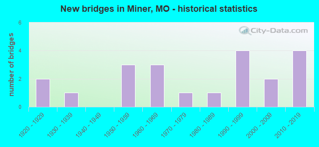
- New bridges - historical statistics
- 21920-1929
- 11930-1939
- 31950-1959
- 31960-1969
- 11970-1979
- 11980-1989
- 41990-1999
- 22000-2009
- 42010-2019

- Reconstructed bridges - Historical Statistics
- 21950-1959
- 01960-1969
- 11970-1979
- 21980-1989


- Bridge Condition - Deck
- 9.1%Excellent
- 18.2%Very good
- 54.5%Good
- 9.1%Satisfactory
- 9.1%Fair

- Bridge Condition - Superstructure
- 9.1%Excellent
- 36.4%Very good
- 18.2%Good
- 18.2%Satisfactory
- 18.2%Fair

- Bridge Condition - Substructure
- 18.2%Very good
- 27.3%Good
- 36.4%Satisfactory
- 9.1%Fair
- 9.1%Critical

- Bridge Condition - Channel
- 58.3%Good
- 16.7%Satisfactory
- 25.0%Fair

- Bridge Condition - Culverts
- 25.0%Good
- 75.0%Satisfactory
Find on map >> Show street view
Structure Number: 11762, Location: S 4 T 26 N R 14 E (Lat: 36.920722, Lng: -89.555256), Route carried "on" structure: State highway HH, Year Built: 1998, Status: Open, Structure Length: 1.39m (4.56ft), Average Daily Traffic: 5,499 (year 2021), Truck Traffic: 13%, Average Future Daily Traffic: 7,974 (year 2041), Design Load: HS 20+Mod, Features Intersected: ST JOHNS DRAIN DTC
Minimum Vertical Clearance: 30+ m (98+ ft), Kilometerpoint: 4.950, Lanes on structure: 2, Owner: State Highway Agency, Approaching Roadway Width: 7.3m (24.0ft), Material/Design: Concrete continuous, Design/Construction: Culvert, Number Of Spans In Main Unit: 3, Length of Maximum Span: 4.5m (14.8ft)
Condition: Channel: Good, Culverts: Good, Structural Evaluation: Better than present minimum criteria, Waterway Adequacy: Equal to present desirable criteria, Approach Roadway Alignment: Equal to present desirable criteria, Designated Inspection Frequency: Every 24 months, Inspection Date: December 2020
Find on map >> Show street view
Structure Number: 11908, Location: S 3 T 26 N R 14 E (Lat: 36.920008, Lng: -89.533847), Route carried "on" structure: State highway HH, Year Built: 1998, Status: Open, Structure Length: 9.78m (32.09ft), Average Daily Traffic: 5,499 (year 2021), Truck Traffic: 13%, Average Future Daily Traffic: 7,974 (year 2041), Design Load: HS 20, Features Intersected: IS 55
Minimum Vertical Clearance: 30+ m (98+ ft), Kilometerpoint: 6.828, Lanes on structure: 3, Lanes under structure: 4, Owner: State Highway Agency, Approaching Roadway Width: 12.0m (39.4ft), Material/Design: Steel continuous, Design/Construction: Stringer/Multi-beam, Number Of Spans In Main Unit: 2, Length of Maximum Span: 39.0m (128.0ft), Curb-To-Curb Width: 12.0m (39.4ft), Out-to-Out Width: 12.8m (42.0ft)
Condition: Deck: Good, Superstructure: Very good, Substructure: Good, Operating Rating: 54.9 metric tons, Method Used To Determine Operating Rating: Load Factor (LF), Inventory Rating: 32.4 metric tons, Method Used To Determine Inventory Rating: Load Factor (LF), Structural Evaluation: Better than present minimum criteria, Deck Geometry: Meets minimum limits, Approach Roadway Alignment: Equal to present desirable criteria, Designated Inspection Frequency: Every 24 months, Inspection Date: Febuary 2021, Deck Structure Type: Concrete Cast-file-Place, Wearing Surface/Protective System: Wearing Surface: Monolithic Concrete, Deck Protection: Internally Sealed
Find on map >> Show street view
Structure Number: 15878, Location: S 36 T 27 N R 14 E (Lat: 36.935678, Lng: -89.494400), Route carried "on" structure: County highway 102, Year Built: 1968, Year Reconstructed: 1988, Status: Open, Structure Length: 2.04m (6.69ft), Average Daily Traffic: 35 (year 2021), Truck Traffic: 10%, Average Future Daily Traffic: 49 (year 2041), Features Intersected: GLADE DRAIN DTCH, Facility Carried by Structure: COUNTY RD 532
Minimum Vertical Clearance: 30+ m (98+ ft), Kilometerpoint: 3.701, Lanes on structure: 2, Owner: Local Agency, Approaching Roadway Width: 7.3m (24.0ft), Material/Design: Steel, Design/Construction: Stringer/Multi-beam, Number Of Spans In Main Unit: 3, Length of Maximum Span: 9.1m (29.9ft), Curb-To-Curb Width: 7.3m (24.0ft), Out-to-Out Width: 7.7m (25.3ft)
Condition: Deck: Good, Superstructure: Good, Substructure: Satisfactory, Channel: Satisfactory, Operating Rating: 38.7 metric tons, Method Used To Determine Operating Rating: Allowable Stress (AS), Inventory Rating: 23.4 metric tons, Method Used To Determine Inventory Rating: Allowable Stress (AS), Structural Evaluation: Equal to present minimum criteria, Deck Geometry: Equal to present minimum criteria, Waterway Adequacy: Better than present minimum criteria, Approach Roadway Alignment: Equal to present minimum criteria, Designated Inspection Frequency: Every 24 months, Inspection Date: January 2021, Deck Structure Type: Concrete Cast-file-Place, Wearing Surface/Protective System: Wearing Surface: Bituminous
Find on map >> Show street view
Structure Number: 1598, Location: S 2 T 26 N R 14 E (Lat: 36.920747, Lng: -89.502508), Route carried "on" structure: County highway 105, Year Built: 1989, Status: Open, Structure Length: 1.65m (5.41ft), Average Daily Traffic: 40 (year 2021), Truck Traffic: 10%, Average Future Daily Traffic: 56 (year 2041), Features Intersected: DRAIN DTCH, Facility Carried by Structure: COUNTY RD 538
Minimum Vertical Clearance: 30+ m (98+ ft), Kilometerpoint: 2.736, Lanes on structure: 2, Owner: Local Agency, Approaching Roadway Width: 6.1m (20.0ft), Material/Design: Steel, Design/Construction: Stringer/Multi-beam, Number Of Spans In Main Unit: 1, Length of Maximum Span: 15.2m (49.9ft), Curb-To-Curb Width: 6.9m (22.6ft), Out-to-Out Width: 7.3m (24.0ft)
Condition: Deck: Good, Superstructure: Good, Substructure: Good, Channel: Good, Operating Rating: 45.0 metric tons, Method Used To Determine Operating Rating: Allowable Stress (AS), Inventory Rating: 27.0 metric tons, Method Used To Determine Inventory Rating: Allowable Stress (AS), Structural Evaluation: Equal to present minimum criteria, Deck Geometry: Somewhat better than minimum adequacy, Waterway Adequacy: Better than present minimum criteria, Approach Roadway Alignment: Meets minimum limits, Designated Inspection Frequency: Every 24 months, Inspection Date: January 2021, Deck Structure Type: Concrete Cast-file-Place, Wearing Surface/Protective System: Wearing Surface: Monolithic Concrete
Find on map >> Show street view
Structure Number: 15986, Location: S 14 T 26 N R 14 E (Lat: 36.902506, Lng: -89.504492), Route carried "on" structure: County highway 105, Year Built: 1925, Year Reconstructed: 1983, Status: Posted for load, Structure Length: 2.74m (8.99ft), Average Daily Traffic: 500 (year 2021), Truck Traffic: 10%, Average Future Daily Traffic: 700 (year 2041), Features Intersected: NORTH CUT DTCH, Facility Carried by Structure: COUNTY RD 538
Minimum Vertical Clearance: 30+ m (98+ ft), Kilometerpoint: 4.989, Lanes on structure: 2, Owner: Local Agency, Approaching Roadway Width: 6.7m (22.0ft), Material/Design: Steel, Design/Construction: Stringer/Multi-beam, Number Of Spans In Main Unit: 3, Length of Maximum Span: 9.1m (29.9ft), Curb-To-Curb Width: 8.1m (26.6ft), Out-to-Out Width: 8.4m (27.6ft)
Condition: Deck: Satisfactory, Superstructure: Satisfactory, Substructure: Satisfactory, Channel: Good, Operating Rating: 23.4 metric tons, Method Used To Determine Operating Rating: Allowable Stress (AS), Inventory Rating: 12.6 metric tons, Method Used To Determine Inventory Rating: Allowable Stress (AS), Structural Evaluation: Meets minimum limits, Deck Geometry: Somewhat better than minimum adequacy, Waterway Adequacy: Better than present minimum criteria, Approach Roadway Alignment: Somewhat better than minimum adequacy, Bridge Posting: Required (Relationship of Operating Rating to Maximum Legal Load: 0.1 - 9.9% below), Designated Inspection Frequency: Every 24 months, Inspection Date: January 2021, Deck Structure Type: Concrete Cast-file-Place, Wearing Surface/Protective System: Wearing Surface: Monolithic Concrete
Find on map >> Show street view
Structure Number: 202, Location: S 24 T 26 N R 14 E (Lat: 36.887836, Lng: -89.492389), Route carried "on" structure: State highway CC, Year Built: 1959, Status: Open, Structure Length: 7.80m (25.59ft), Average Daily Traffic: 438 (year 2021), Truck Traffic: 11%, Average Future Daily Traffic: 613 (year 2041), Design Load: H 15, Features Intersected: IS 57
Minimum Vertical Clearance: 30+ m (98+ ft), Kilometerpoint: 1.812, Lanes on structure: 2, Lanes under structure: 4, Owner: State Highway Agency, Approaching Roadway Width: 6.1m (20.0ft), Skew: 2 degrees, Material/Design: Steel continuous, Design/Construction: Stringer/Multi-beam, Number Of Spans In Main Unit: 4, Length of Maximum Span: 21.9m (71.9ft), Curb-To-Curb Width: 7.3m (24.0ft), Out-to-Out Width: 8.1m (26.6ft)
Condition: Deck: Fair, Superstructure: Satisfactory, Substructure: Good, Operating Rating: 36.9 metric tons, Method Used To Determine Operating Rating: Allowable Stress (AS), Inventory Rating: 16.2 metric tons, Method Used To Determine Inventory Rating: Allowable Stress (AS), Structural Evaluation: Somewhat better than minimum adequacy, Deck Geometry: Meets minimum limits, Underclear: Meets minimum limits, Approach Roadway Alignment: Equal to present minimum criteria, Designated Inspection Frequency: Every 24 months, Inspection Date: November 2021, Deck Structure Type: Concrete Cast-file-Place, Wearing Surface/Protective System: Wearing Surface: Bituminous
Find on map >> Show street view
Structure Number: 23279, Location: S 29 T 26 N R 14 E (Lat: 36.881581, Lng: -89.560467), Route carried "on" structure: City street , Year Built: 1960, Year Reconstructed: 1994, Status: Open, Structure Length: 2.35m (7.71ft), Average Daily Traffic: 300 (year 2021), Truck Traffic: 10%, Average Future Daily Traffic: 435 (year 2041), Design Load: HS 20, Features Intersected: ST JOHN'S DTCH, Facility Carried by Structure: E KATHLEEN ST
Minimum Vertical Clearance: 30+ m (98+ ft), Kilometerpoint: 0.161, Lanes on structure: 2, Owner: City or Municipal Highway Agency, Approaching Roadway Width: 8.5m (27.9ft), Skew: 1 degrees, Material/Design: Prestressed concrete, Design/Construction: Box Beam or Girders - Multiple, Number Of Spans In Main Unit: 3, Length of Maximum Span: 7.6m (24.9ft), Curb-To-Curb Width: 8.5m (27.9ft), Out-to-Out Width: 8.5m (27.9ft)
Condition: Deck: Very good, Superstructure: Fair, Substructure: Fair, Channel: Good, Operating Rating: 54.0 metric tons, Method Used To Determine Operating Rating: Load Factor (LF), Inventory Rating: 32.4 metric tons, Method Used To Determine Inventory Rating: Load Factor (LF), Structural Evaluation: Somewhat better than minimum adequacy, Deck Geometry: Equal to present minimum criteria, Waterway Adequacy: Better than present minimum criteria, Approach Roadway Alignment: Better than present minimum criteria, Designated Inspection Frequency: Every 24 months, Inspection Date: January 2021, Deck Structure Type: Concrete Precast Panels, Wearing Surface/Protective System: Wearing Surface: Bituminous
Find on map >> Show street view
Structure Number: 23281, Location: S 26 T 26 N R 13 E (Lat: 36.875753, Lng: -89.623856), Route carried "on" structure: City street , Year Built: 1978, Status: Closed, Structure Length: 2.10m (6.89ft), Average Daily Traffic: 300 (year 2021), Truck Traffic: 10%, Average Future Daily Traffic: 435 (year 2041), Design Load: H 15, Features Intersected: DTCH NO 4, Facility Carried by Structure: COMPRESS RD
Minimum Vertical Clearance: 30+ m (98+ ft), Kilometerpoint: 0.322, Lanes on structure: 2, Owner: City or Municipal Highway Agency, Approaching Roadway Width: 9.1m (29.9ft), Material/Design: Concrete, Design/Construction: Channel Beam, Number Of Spans In Main Unit: 3, Length of Maximum Span: 9.4m (30.8ft), Curb-To-Curb Width: 7.5m (24.6ft), Out-to-Out Width: 8.3m (27.2ft)
Condition: Deck: Good, Superstructure: Fair, Substructure: Critical, Channel: Satisfactory, Deck Geometry: Somewhat better than minimum adequacy, Waterway Adequacy: Better than present minimum criteria, Approach Roadway Alignment: Equal to present desirable criteria, Bridge Posting: Required (Relationship of Operating Rating to Maximum Legal Load: > 39.9% below), Length Of Structure Improvement: 0.29m (0.95ft), Designated Inspection Frequency: Every 24 months, Inspection Date: January 2021, Bridge Improvement Cost: $262,000, Roadway Improvement Cost: $26,000, Total Project Cost: $393,000 ( Estimate for 2022), Deck Structure Type: Concrete Precast Panels, Wearing Surface/Protective System: Wearing Surface: Bituminous
Find on map >> Show street view
Structure Number: 3123, Location: S 27 T 26 N R 14 E (Lat: 36.876256, Lng: -89.525069), Route carried "on" structure: Interstate 57, Year Built: 2005, Status: Open, Structure Length: 5.60m (18.37ft), Average Daily Traffic: 9,131 (year 2021), Truck Traffic: 44%, Average Future Daily Traffic: 17,349 (year 2041), Design Load: HS 25 or greater, Features Intersected: NORTH CUT DTCH
Minimum Vertical Clearance: 30+ m (98+ ft), Kilometerpoint: 1.154, Lanes on structure: 2, Base Highway Network: Yes, Owner: State Highway Agency, Approaching Roadway Width: 12.2m (40.0ft), Skew: 2 degrees, Material/Design: Steel continuous, Design/Construction: Stringer/Multi-beam, Number Of Spans In Main Unit: 3, Length of Maximum Span: 24.4m (80.1ft), Curb-To-Curb Width: 12.2m (40.0ft), Out-to-Out Width: 13.0m (42.7ft)
Condition: Deck: Good, Superstructure: Very good, Substructure: Satisfactory, Channel: Fair, Inventory Rating: 70.2 metric tons, Method Used To Determine Inventory Rating: Load Factor (LF), Structural Evaluation: Equal to present minimum criteria, Deck Geometry: Better than present minimum criteria, Waterway Adequacy: Superior to present desirable criteria, Approach Roadway Alignment: Equal to present desirable criteria, Designated Inspection Frequency: Every 24 months, Inspection Date: Febuary 2021, Deck Structure Type: Concrete Cast-file-Place, Wearing Surface/Protective System: Wearing Surface: Monolithic Concrete, Deck Protection: Epoxy Coated Reinforcing
Find on map >> Show street view
Structure Number: 31231, Location: S 27 T 26 N R 14 E (Lat: 36.876303, Lng: -89.525694), Route carried "on" structure: Interstate 57, Year Built: 2005, Status: Open, Structure Length: 5.60m (18.37ft), Average Daily Traffic: 7,461 (year 2021), Truck Traffic: 40%, Average Future Daily Traffic: 14,176 (year 2041), Design Load: HS 25 or greater, Features Intersected: NORTH CUT DTCH
Minimum Vertical Clearance: 30+ m (98+ ft), Kilometerpoint: 34.757, Lanes on structure: 2, Base Highway Network: Yes, Owner: State Highway Agency, Approaching Roadway Width: 12.2m (40.0ft), Skew: 2 degrees, Material/Design: Steel continuous, Design/Construction: Stringer/Multi-beam, Number Of Spans In Main Unit: 3, Length of Maximum Span: 24.4m (80.1ft), Curb-To-Curb Width: 12.2m (40.0ft), Out-to-Out Width: 13.0m (42.7ft)
Condition: Deck: Good, Superstructure: Very good, Substructure: Satisfactory, Channel: Fair, Inventory Rating: 62.1 metric tons, Method Used To Determine Inventory Rating: Load Factor (LF), Structural Evaluation: Equal to present minimum criteria, Deck Geometry: Better than present minimum criteria, Waterway Adequacy: Superior to present desirable criteria, Approach Roadway Alignment: Equal to present desirable criteria, Designated Inspection Frequency: Every 24 months, Inspection Date: Febuary 2021, Deck Structure Type: Concrete Cast-file-Place, Wearing Surface/Protective System: Wearing Surface: Monolithic Concrete, Deck Protection: Epoxy Coated Reinforcing
Find on map >> Show street view
Structure Number: 3317, Location: S 1 T 25 N R 14 E (Lat: 36.835597, Lng: -89.489375), Route carried "on" structure: State highway CC, Year Built: 2010, Status: Open, Structure Length: 1.89m (6.20ft), Average Daily Traffic: 438 (year 2021), Truck Traffic: 11%, Average Future Daily Traffic: 613 (year 2041), Design Load: HS 20, Features Intersected: ASH SLU DTCH
Minimum Vertical Clearance: 30+ m (98+ ft), Kilometerpoint: 7.839, Lanes on structure: 2, Owner: State Highway Agency, Approaching Roadway Width: 7.3m (24.0ft), Skew: 2 degrees, Material/Design: Prestressed concrete, Design/Construction: Box Beam or Girders - Multiple, Number Of Spans In Main Unit: 1, Length of Maximum Span: 18.3m (60.0ft), Curb-To-Curb Width: 7.3m (24.0ft), Out-to-Out Width: 7.9m (25.9ft)
Condition: Deck: Excellent, Superstructure: Excellent, Substructure: Very good, Channel: Fair, Operating Rating: 65.7 metric tons, Method Used To Determine Operating Rating: Load Factor (LF), Inventory Rating: 39.6 metric tons, Method Used To Determine Inventory Rating: Load Factor (LF), Structural Evaluation: Equal to present desirable criteria, Deck Geometry: Meets minimum limits, Waterway Adequacy: Superior to present desirable criteria, Approach Roadway Alignment: Equal to present desirable criteria, Designated Inspection Frequency: Every 24 months, Inspection Date: November 2021, Deck Structure Type: Concrete Precast Panels, Wearing Surface/Protective System: Wearing Surface: Bituminous, Membrane: Other
Find on map >> Show street view
Structure Number: 3362, Location: S 27 T 27 N R 14 E (Lat: 36.956519, Lng: -89.534303), Route carried "on" structure: State highway H, Year Built: 2011, Status: Open, Structure Length: 5.62m (18.44ft), Average Daily Traffic: 2,930 (year 2021), Truck Traffic: 12%, Average Future Daily Traffic: 4,249 (year 2041), Design Load: HS 20, Features Intersected: IS 55
Minimum Vertical Clearance: 30+ m (98+ ft), Kilometerpoint: 14.888, Lanes on structure: 2, Lanes under structure: 4, Owner: State Highway Agency, Approaching Roadway Width: 10.4m (34.1ft), Skew: 4 degrees, Material/Design: Prestressed concrete, Design/Construction: Box Beam or Girders - Single/Spread, Number Of Spans In Main Unit: 2, Length of Maximum Span: 28.0m (91.9ft), Curb-To-Curb Width: 10.4m (34.1ft), Out-to-Out Width: 11.0m (36.1ft)
Condition: Deck: Very good, Superstructure: Very good, Substructure: Very good, Inventory Rating: 34.2 metric tons, Method Used To Determine Inventory Rating: Load Factor (LF), Structural Evaluation: Equal to present desirable criteria, Deck Geometry: Somewhat better than minimum adequacy, Underclear: Meets minimum limits, Approach Roadway Alignment: Equal to present desirable criteria, Designated Inspection Frequency: Every 24 months, Inspection Date: Febuary 2021, Deck Structure Type: Concrete Cast-file-Place, Wearing Surface/Protective System: Wearing Surface: Monolithic Concrete, Deck Protection: Epoxy Coated Reinforcing
Find on map >> Show street view
Structure Number: 4944, Location: S 15 T 26 N R 14 E (Lat: 36.896353, Lng: -89.520483), Route carried "on" structure: US 62, Year Built: 1926, Year Reconstructed: 1961, Status: Open, Structure Length: 0.71m (2.33ft), Average Daily Traffic: 7,621 (year 2021), Truck Traffic: 7%, Average Future Daily Traffic: 11,050 (year 2041), Design Load: H 20, Features Intersected: DRAIN DTCH NO 6
Minimum Vertical Clearance: 30+ m (98+ ft), Kilometerpoint: 101.374, Lanes on structure: 2, Owner: State Highway Agency, Approaching Roadway Width: 11.0m (36.1ft), Skew: 1 degrees, Material/Design: Concrete continuous, Design/Construction: Culvert, Number Of Spans In Main Unit: 2, Length of Maximum Span: 3.4m (11.2ft)
Condition: Channel: Good, Culverts: Satisfactory, Operating Rating: 72.0 metric tons, Method Used To Determine Operating Rating: Load Factor (LF), Inventory Rating: 43.2 metric tons, Method Used To Determine Inventory Rating: Load Factor (LF), Structural Evaluation: Equal to present minimum criteria, Waterway Adequacy: Better than present minimum criteria, Approach Roadway Alignment: Equal to present desirable criteria, Designated Inspection Frequency: Every 24 months, Inspection Date: December 2020
Find on map >> Show street view
Structure Number: 662, Location: S 34 T 27 N R 14 E (Lat: 36.943497, Lng: -89.534242), Route carried "on" structure: Interstate 55, Year Built: 1962, Status: Open, Structure Length: 0.76m (2.49ft), Average Daily Traffic: 19,207 (year 2021), Truck Traffic: 29%, Average Future Daily Traffic: 36,493 (year 2041), Design Load: HS 20, Features Intersected: LATERAL DTCH NO 4
Minimum Vertical Clearance: 30+ m (98+ ft), Kilometerpoint: 223.443, Lanes on structure: 4, Base Highway Network: Yes, Owner: State Highway Agency, Approaching Roadway Width: 39.0m (128.0ft), Skew: 20 degrees, Material/Design: Concrete continuous, Design/Construction: Culvert, Number Of Spans In Main Unit: 2, Length of Maximum Span: 3.7m (12.1ft)
Condition: Channel: Good, Culverts: Satisfactory, Operating Rating: 79.2 metric tons, Method Used To Determine Operating Rating: Load Factor (LF), Inventory Rating: 47.7 metric tons, Method Used To Determine Inventory Rating: Load Factor (LF), Structural Evaluation: Equal to present minimum criteria, Waterway Adequacy: Equal to present minimum criteria, Approach Roadway Alignment: Equal to present desirable criteria, Designated Inspection Frequency: Every 24 months, Inspection Date: December 2020
Find on map >> Show street view
Structure Number: 9271, Location: S 34 T 27 N R 14 E (Lat: 36.942853, Lng: -89.534636), Route carried "on" structure: State highway H, Year Built: 1937, Year Reconstructed: 1962, Status: Open, Structure Length: 0.76m (2.49ft), Average Daily Traffic: 3,540 (year 2021), Truck Traffic: 12%, Average Future Daily Traffic: 5,133 (year 2041), Design Load: H 15, Features Intersected: LATERAL DTCH NO 4
Minimum Vertical Clearance: 30+ m (98+ ft), Kilometerpoint: 16.486, Lanes on structure: 2, Owner: State Highway Agency, Approaching Roadway Width: 8.5m (27.9ft), Material/Design: Concrete continuous, Design/Construction: Culvert, Number Of Spans In Main Unit: 2, Length of Maximum Span: 3.7m (12.1ft)
Condition: Channel: Good, Culverts: Satisfactory, Operating Rating: 74.7 metric tons, Method Used To Determine Operating Rating: Load Factor (LF), Inventory Rating: 45.0 metric tons, Method Used To Determine Inventory Rating: Load Factor (LF), Structural Evaluation: Equal to present minimum criteria, Waterway Adequacy: Equal to present minimum criteria, Approach Roadway Alignment: Equal to present desirable criteria, Designated Inspection Frequency: Every 24 months, Inspection Date: December 2020
Find on map >> Show street view
Structure Number: 11908, Location: S 3 T 26 N R 14 E (Lat: 36.920008, Lng: -89.533847), Route carried "under" structure: Interstate 55, Year Built: 1998, Structure Length: 0. m, Average Daily Traffic: 9,385 (year 2021), Truck Traffic: 29%, Features Intersected: IS 55, Facility Carried by Structure: RT HH E
Minimum Vertical Clearance: 5.56m (18.24ft), Kilometerpoint: 226.057, Lanes on structure: 3, Lanes under structure: 2, Material/Design: Steel continuous, Design/Construction: Stringer/Multi-beam, Length of Maximum Span: 39.0m (128.0ft)
Find on map >> Show street view
Structure Number: 11908, Location: S 3 T 26 N R 14 E (Lat: 36.920008, Lng: -89.533847), Route carried "under" structure: Interstate 55, Year Built: 1998, Structure Length: 0. m, Average Daily Traffic: 8,320 (year 2021), Truck Traffic: 35%, Features Intersected: IS 55, Facility Carried by Structure: RT HH E
Minimum Vertical Clearance: 5.54m (18.18ft), Kilometerpoint: 111.655, Lanes on structure: 3, Lanes under structure: 2, Material/Design: Steel continuous, Design/Construction: Stringer/Multi-beam, Length of Maximum Span: 39.0m (128.0ft)
Find on map >> Show street view
Structure Number: 202, Location: S 24 T 26 N R 14 E (Lat: 36.887836, Lng: -89.492389), Route carried "under" structure: Interstate 57, Year Built: 1959, Structure Length: 0. m, Average Daily Traffic: 7,461 (year 2021), Truck Traffic: 40%, Features Intersected: IS 57, Facility Carried by Structure: RT CC S
Minimum Vertical Clearance: 4.62m (15.16ft), Kilometerpoint: 31.537, Lanes on structure: 2, Lanes under structure: 2, Material/Design: Steel continuous, Design/Construction: Stringer/Multi-beam, Length of Maximum Span: 21.9m (71.9ft)
Find on map >> Show street view
Structure Number: 202, Location: S 24 T 26 N R 14 E (Lat: 36.887836, Lng: -89.492389), Route carried "under" structure: Interstate 57, Year Built: 1959, Structure Length: 0. m, Average Daily Traffic: 9,131 (year 2021), Truck Traffic: 44%, Features Intersected: IS 57, Facility Carried by Structure: RT CC S
Minimum Vertical Clearance: 4.62m (15.16ft), Kilometerpoint: 4.368, Lanes on structure: 2, Lanes under structure: 2, Material/Design: Steel continuous, Design/Construction: Stringer/Multi-beam, Length of Maximum Span: 21.9m (71.9ft)
Find on map >> Show street view
Structure Number: 3362, Location: S 27 T 27 N R 14 E (Lat: 36.956519, Lng: -89.534303), Route carried "under" structure: Interstate 55, Year Built: 2011, Structure Length: 0. m, Average Daily Traffic: 9,385 (year 2021), Truck Traffic: 29%, Features Intersected: IS 55, Facility Carried by Structure: RT H S
Minimum Vertical Clearance: 5.11m (16.77ft), Kilometerpoint: 222.009, Lanes on structure: 2, Lanes under structure: 2, Material/Design: Prestressed concrete, Design/Construction: Box Beam or Girders - Single/Spread, Length of Maximum Span: 28.0m (91.9ft)
Find on map >> Show street view
Structure Number: 3362, Location: S 27 T 27 N R 14 E (Lat: 36.956519, Lng: -89.534303), Route carried "under" structure: Interstate 55, Year Built: 2011, Structure Length: 0. m, Average Daily Traffic: 9,822 (year 2021), Truck Traffic: 33%, Features Intersected: IS 55, Facility Carried by Structure: RT H S
Minimum Vertical Clearance: 5.08m (16.67ft), Kilometerpoint: 115.722, Lanes on structure: 2, Lanes under structure: 2, Material/Design: Prestressed concrete, Design/Construction: Box Beam or Girders - Single/Spread, Length of Maximum Span: 28.0m (91.9ft)