Miner, Missouri
Submit your own pictures of this city and show them to the world
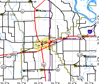
- OSM Map
- General Map
- Google Map
- MSN Map
Population change since 2000: -14.5%
| Males: 382 | |
| Females: 521 |
| Median resident age: | 40.1 years |
| Missouri median age: | 39.1 years |
Zip codes: 63801.
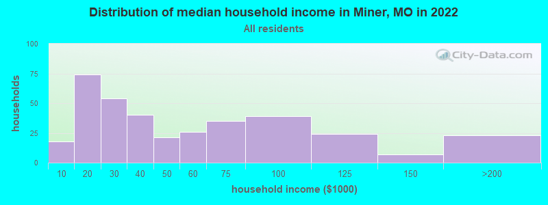
| Miner: | $37,571 |
| MO: | $64,811 |
Estimated per capita income in 2022: $25,641 (it was $17,409 in 2000)
Miner city income, earnings, and wages data
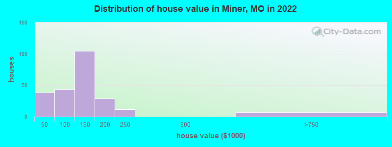
Estimated median house or condo value in 2022: $132,010 (it was $56,700 in 2000)
| Miner: | $132,010 |
| MO: | $221,200 |
Mean prices in 2022: all housing units: $126,867; detached houses: $137,797; mobile homes: $17,034
Median gross rent in 2022: $573.
(21.9% for White Non-Hispanic residents, 4.5% for Black residents, 100.0% for Hispanic or Latino residents, 100.0% for other race residents, 3.8% for two or more races residents)
Detailed information about poverty and poor residents in Miner, MO
Compare current foreclosures near Miner, MO:
| Photo | Address | Area | Beds / Baths | Price | Details |
|---|---|---|---|---|---|

|
#1
Sikes Ave
Sikeston, MO 63801
|
800 sq. feet
|
1 baths 2 beds |
show details | |

|
#2
W 430th Rd
East Prairie, MO 63845
|
1,680 sq. feet
|
2 baths 3 beds |
show details | |

|
#3
Lombardy Dr
East Prairie, MO 63845
|
1,293 sq. feet
|
1 baths 4 beds |
show details | |

|
#4
Chester St
Benton, MO 63736
|
1,316 sq. feet
|
1 baths 3 beds |
show details | |

|
#5
Goodhope St
Sikeston, MO 63801
|
1,001 sq. feet
|
1 baths 2 beds |
show details | |

|
#6
Alesia Dr
East Prairie, MO 63845
|
- sq. feet
|
2 baths 4 beds |
show details | |

|
#7
Pam St
Sikeston, MO 63801
|
1,122 sq. feet
|
- baths - beds |
show details | |

|
#8
East St
Sikeston, MO 63801
|
1,295 sq. feet
|
- baths - beds |
show details | |

|
#9
Danforth St
Charleston, MO 63834
|
- sq. feet
|
- baths - beds |
show details | |

|
#10
Lombardy Dr Apt 2
East Prairie, MO 63845
|
- sq. feet
|
- baths - beds |
show details |
| Photo | Address | Area | Beds / Baths | Price | Details |
|---|---|---|---|---|---|

|
#11
Flad St
Oran, MO 63771
|
- sq. feet
|
- baths - beds |
show details | |

|
#12
Sandy Ln
Benton, MO 63736
|
- sq. feet
|
- baths - beds |
show details | |

|
#13
E Commercial St
Charleston, MO 63834
|
- sq. feet
|
- baths - beds |
show details | |

|
#14
Shannon St
East Prairie, MO 63845
|
- sq. feet
|
- baths - beds |
show details | |

|
#15
Sandown Rd
Benton, MO 63736
|
1,064 sq. feet
|
- baths - beds |
show details | |

|
#16
Missouri Ave
Sikeston, MO 63801
|
1,252 sq. feet
|
- baths - beds |
show details | |

|
#17
S 525th Rd
East Prairie, MO 63845
|
- sq. feet
|
- baths - beds |
show details | |

|
#18
County Road 518
Bell City, MO 63735
|
- sq. feet
|
- baths - beds |
show details | |

|
#19
Kyle Dr
Benton, MO 63736
|
- sq. feet
|
- baths - beds |
show details | |

|
#20
State Hwy E
Benton, MO 63736
|
- sq. feet
|
- baths - beds |
show details |
| Photo | Address | Area | Beds / Baths | Price | Details |
|---|---|---|---|---|---|

|
#21
Bland St
Benton, MO 63736
|
- sq. feet
|
- baths - beds |
show details | |

|
#22
County Highway 331
Benton, MO 63736
|
1,479 sq. feet
|
- baths - beds |
show details | |

|
#23
County Rd 333
Benton, MO 63736
|
- sq. feet
|
- baths - beds |
show details | |

|
#24
Stull Dr
Benton, MO 63736
|
1,664 sq. feet
|
- baths - beds |
show details | |

|
#25
County Highway 427
Oran, MO 63771
|
- sq. feet
|
- baths - beds |
show details | |

|
#26
Fox Meadows Rd
Sikeston, MO 63801
|
1,602 sq. feet
|
- baths - beds |
show details | |

|
#27
Us Highway 61
Sikeston, MO 63801
|
- sq. feet
|
- baths - beds |
show details | |

|
#28
W 220th Rd
Bertrand, MO 63823
|
- sq. feet
|
- baths - beds |
show details | |

|
#29
Kate Dr
Sikeston, MO 63801
|
- sq. feet
|
- baths - beds |
show details | |

|
#30
Petroleum St
Sikeston, MO 63801
|
972 sq. feet
|
- baths - beds |
show details |
| Photo | Address | Area | Beds / Baths | Price | Details |
|---|---|---|---|---|---|

|
#31
Cottonwood Dr # A
Sikeston, MO 63801
|
2,543 sq. feet
|
- baths - beds |
show details | |

|
#32
Paula Dr
Sikeston, MO 63801
|
1,184 sq. feet
|
- baths - beds |
show details | |

|
#33
S Illinois Ave Apt A
Sikeston, MO 63801
|
- sq. feet
|
- baths - beds |
show details | |

|
#34
Ashley Dr
Sikeston, MO 63801
|
1,554 sq. feet
|
- baths - beds |
show details | |

|
#35
Us Highway 62 E
Sikeston, MO 63801
|
- sq. feet
|
- baths - beds |
show details | |

|
#36
E Gladys St
Sikeston, MO 63801
|
1,134 sq. feet
|
- baths - beds |
show details | |

|
#37
S Illinois Ave Apt A3
Sikeston, MO 63801
|
- sq. feet
|
- baths - beds |
show details | |

|
#38
Aspen Trce
Sikeston, MO 63801
|
1,644 sq. feet
|
- baths - beds |
show details | |

|
#39
Aspen Trce
Sikeston, MO 63801
|
1,536 sq. feet
|
- baths - beds |
show details | |

|
#40
Dudley Dr
Sikeston, MO 63801
|
1,536 sq. feet
|
- baths - beds |
show details |
| Photo | Address | Area | Beds / Baths | Price | Details |
|---|---|---|---|---|---|

|
#41
E Center St
Sikeston, MO 63801
|
- sq. feet
|
- baths - beds |
show details | |

|
#42
Benton St
Sikeston, MO 63801
|
1,000 sq. feet
|
- baths - beds |
show details | |

|
#43
Tulip Trce
Sikeston, MO 63801
|
- sq. feet
|
- baths - beds |
show details | |

|
#44
N 2nd St Apt 10
Sikeston, MO 63801
|
- sq. feet
|
- baths - beds |
show details | |

|
#45
S New Madrid St
Sikeston, MO 63801
|
810 sq. feet
|
- baths - beds |
show details | |

|
#46
Cotton Ridge Pl
Sikeston, MO 63801
|
1,350 sq. feet
|
- baths - beds |
show details | |

|
#47
N Handy St
Sikeston, MO 63801
|
- sq. feet
|
- baths - beds |
show details | |

|
#48
Young St
Sikeston, MO 63801
|
- sq. feet
|
- baths - beds |
show details | |

|
#49
State Highway H
Sikeston, MO 63801
|
1,344 sq. feet
|
- baths - beds |
show details | |

|
Check over 1 million property listings on Foreclosure.com!
|
browse all offers | |||


- 61772.8%White alone
- 14316.9%Two or more races
- 9010.6%Black alone
- 121.4%Asian alone
- 30.4%Hispanic
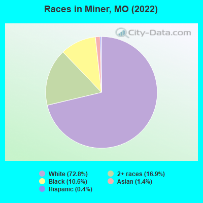
Races in Miner detailed stats: ancestries, foreign born residents, place of birth
According to our research of Missouri and other state lists, there were 4 registered sex offenders living in Miner, Missouri as of May 22, 2024.
The ratio of all residents to sex offenders in Miner is 256 to 1.
Type |
2009 |
2010 |
2011 |
2012 |
2013 |
2014 |
2015 |
2016 |
2017 |
2018 |
2019 |
2020 |
2021 |
2022 |
|---|---|---|---|---|---|---|---|---|---|---|---|---|---|---|
| Murders (per 100,000) | 0 (0.0) | 0 (0.0) | 0 (0.0) | 0 (0.0) | 0 (0.0) | 0 (0.0) | 2 (209.2) | 0 (0.0) | 0 (0.0) | 0 (0.0) | 0 (0.0) | 0 (0.0) | 0 (0.0) | 0 (0.0) |
| Rapes (per 100,000) | 1 (74.5) | 0 (0.0) | 0 (0.0) | 0 (0.0) | 1 (102.4) | 1 (102.7) | 0 (0.0) | 1 (104.6) | 1 (105.8) | 0 (0.0) | 0 (0.0) | 0 (0.0) | 7 (748.7) | 2 (223.2) |
| Robberies (per 100,000) | 0 (0.0) | 1 (101.6) | 0 (0.0) | 3 (304.9) | 0 (0.0) | 1 (102.7) | 1 (104.6) | 1 (104.6) | 2 (211.6) | 1 (105.6) | 0 (0.0) | 0 (0.0) | 1 (107.0) | 0 (0.0) |
| Assaults (per 100,000) | 5 (372.3) | 13 (1,321) | 14 (1,417) | 22 (2,236) | 10 (1,024) | 21 (2,156) | 32 (3,347) | 17 (1,778) | 2 (211.6) | 42 (4,435) | 11 (1,166) | 6 (645.2) | 4 (427.8) | 3 (334.8) |
| Burglaries (per 100,000) | 0 (0.0) | 9 (914.6) | 6 (607.3) | 10 (1,016) | 11 (1,126) | 4 (410.7) | 11 (1,151) | 8 (836.8) | 7 (740.7) | 12 (1,267) | 6 (636.3) | 13 (1,398) | 10 (1,070) | 5 (558.0) |
| Thefts (per 100,000) | 28 (2,085) | 19 (1,931) | 30 (3,036) | 69 (7,012) | 44 (4,504) | 47 (4,825) | 36 (3,766) | 49 (5,126) | 36 (3,810) | 37 (3,907) | 14 (1,485) | 13 (1,398) | 18 (1,925) | 18 (2,009) |
| Auto thefts (per 100,000) | 1 (74.5) | 2 (203.3) | 1 (101.2) | 2 (203.3) | 5 (511.8) | 9 (924.0) | 7 (732.2) | 4 (418.4) | 4 (423.3) | 4 (422.4) | 1 (106.0) | 2 (215.1) | 5 (534.8) | 2 (223.2) |
| Arson (per 100,000) | 0 (0.0) | 0 (0.0) | 0 (0.0) | 1 (101.6) | 0 (0.0) | 0 (0.0) | 0 (0.0) | 2 (209.2) | 1 (105.8) | 0 (0.0) | 0 (0.0) | 0 (0.0) | 0 (0.0) | 0 (0.0) |
| City-Data.com crime index | 223.4 | 452.2 | 455.5 | 906.5 | 586.5 | 839.8 | 1409.0 | 767.8 | 428.6 | 1197.5 | 345.7 | 300.0 | 911.2 | 382.8 |
The City-Data.com crime index weighs serious crimes and violent crimes more heavily. Higher means more crime, U.S. average is 246.1. It adjusts for the number of visitors and daily workers commuting into cities.
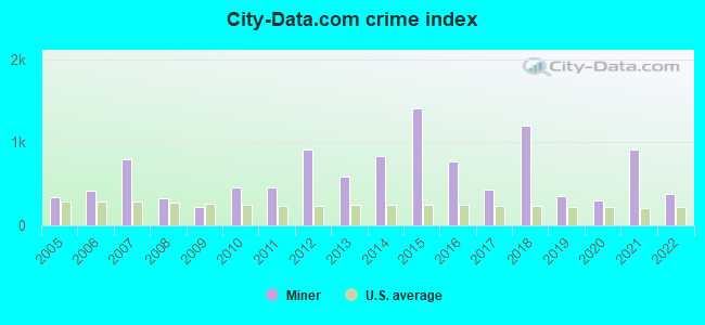
Crime rate in Miner detailed stats: murders, rapes, robberies, assaults, burglaries, thefts, arson
Full-time law enforcement employees in 2020, including police officers: 10 (10 officers - 6 male; 4 female).
| Officers per 1,000 residents here: | 10.75 |
| Missouri average: | 2.53 |
 Recent articles from our blog. Our writers, many of them Ph.D. graduates or candidates, create easy-to-read articles on a wide variety of topics.


 | Missouri Outlaw History (3407 replies) |
| How is the 64134 area in 2021? (9 replies) |
| Interesting Missouri facts. (1186 replies) |
| Long ago on independence square (13162 replies) |
| Why did the city let bannister mall collapse? (44 replies) |
| Where in the world are all of the musicians in Branson? (9 replies) |
Latest news from Miner, MO collected exclusively by city-data.com from local newspapers, TV, and radio stations
Ancestries: American (32.8%), English (7.1%), European (2.2%), Irish (2.2%), Scotch-Irish (1.9%).
Current Local Time: CST time zone
Incorporated in 1951
Elevation: 308 feet
Land area: 4.10 square miles.
Population density: 220 people per square mile (very low).
11 residents are foreign born
| This city: | 1.3% |
| Missouri: | 4.2% |
Median real estate property taxes paid for housing units with mortgages in 2022: $641 (0.5%)
Median real estate property taxes paid for housing units with no mortgage in 2022: $739 (0.7%)
Nearest city with pop. 50,000+: Jackson, TN  (95.8 miles , pop. 59,643).
Nearest city with pop. 200,000+: Memphis, TN (125.1 miles , pop. 650,100).
Nearest city with pop. 1,000,000+: Chicago, IL (356.4 miles , pop. 2,896,016).
Nearest cities:
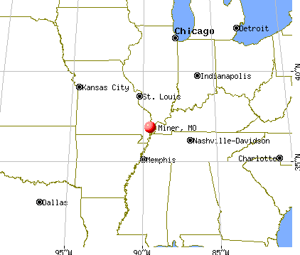
), ), ), Latitude: 36.89 N, Longitude: 89.54 W
Area code commonly used in this area: 573

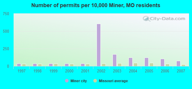
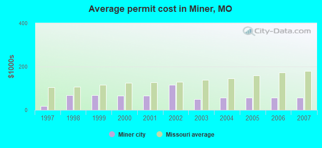
Single-family new house construction building permits:
- 2007: 8 buildings, average cost: $56,800
- 2006: 11 buildings, average cost: $56,800
- 2005: 13 buildings, average cost: $56,800
- 2004: 13 buildings, average cost: $56,800
- 2003: 18 buildings, average cost: $51,200
- 2002: 64 buildings, average cost: $116,300
- 2001: 4 buildings, average cost: $65,000
- 2000: 4 buildings, average cost: $65,000
- 1999: 4 buildings, average cost: $68,000
- 1998: 4 buildings, average cost: $68,000
- 1997: 4 buildings, average cost: $17,500
| Here: | 2.7% |
| Missouri: | 2.8% |
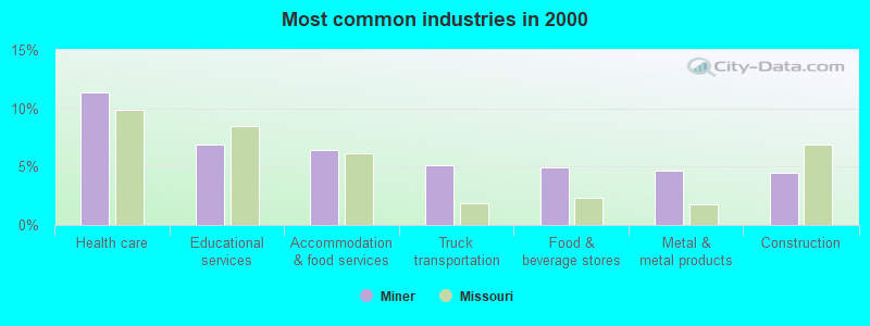
- Health care (11.4%)
- Educational services (6.9%)
- Accommodation & food services (6.5%)
- Truck transportation (5.1%)
- Food & beverage stores (4.9%)
- Metal & metal products (4.7%)
- Construction (4.5%)
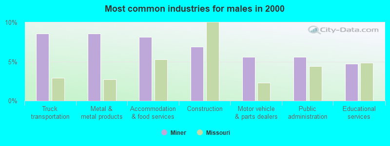
- Truck transportation (8.6%)
- Metal & metal products (8.6%)
- Accommodation & food services (8.2%)
- Construction (6.9%)
- Motor vehicle & parts dealers (5.6%)
- Public administration (5.6%)
- Educational services (4.7%)
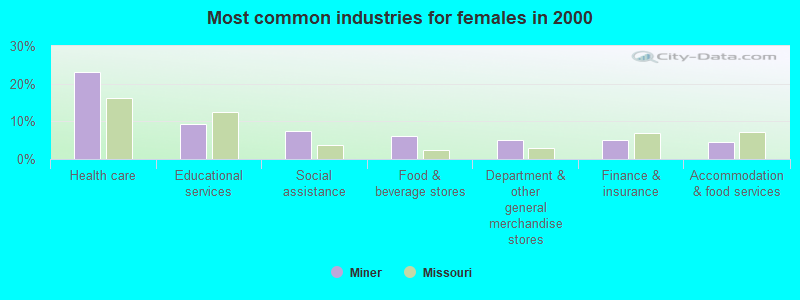
- Health care (23.1%)
- Educational services (9.3%)
- Social assistance (7.4%)
- Food & beverage stores (6.0%)
- Department & other general merchandise stores (5.1%)
- Finance & insurance (5.1%)
- Accommodation & food services (4.6%)
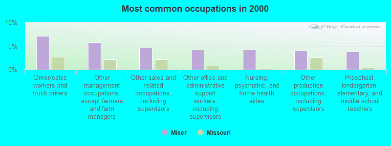
- Driver/sales workers and truck drivers (7.1%)
- Other management occupations, except farmers and farm managers (5.8%)
- Other sales and related occupations, including supervisors (4.7%)
- Other office and administrative support workers, including supervisors (4.2%)
- Nursing, psychiatric, and home health aides (4.2%)
- Other production occupations, including supervisors (4.0%)
- Preschool, kindergarten, elementary, and middle school teachers (3.8%)
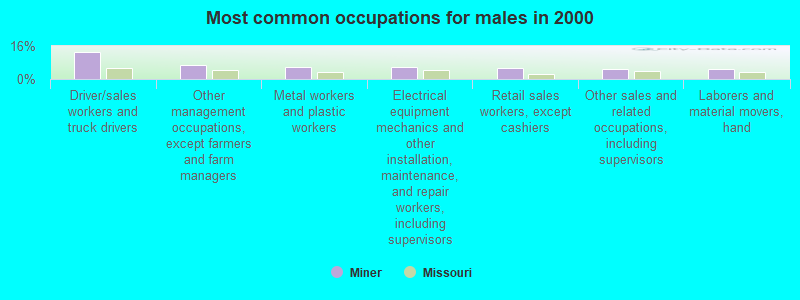
- Driver/sales workers and truck drivers (13.3%)
- Other management occupations, except farmers and farm managers (6.9%)
- Metal workers and plastic workers (5.6%)
- Electrical equipment mechanics and other installation, maintenance, and repair workers, including supervisors (5.6%)
- Retail sales workers, except cashiers (5.2%)
- Other sales and related occupations, including supervisors (4.7%)
- Laborers and material movers, hand (4.7%)
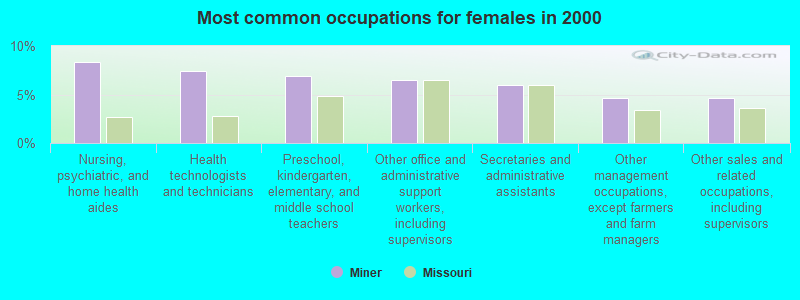
- Nursing, psychiatric, and home health aides (8.3%)
- Health technologists and technicians (7.4%)
- Preschool, kindergarten, elementary, and middle school teachers (6.9%)
- Other office and administrative support workers, including supervisors (6.5%)
- Secretaries and administrative assistants (6.0%)
- Other management occupations, except farmers and farm managers (4.6%)
- Other sales and related occupations, including supervisors (4.6%)
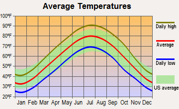
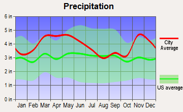
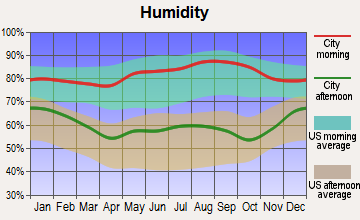
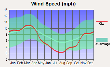
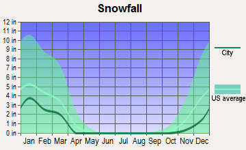
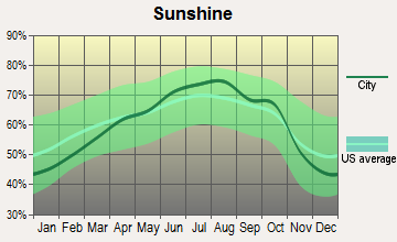
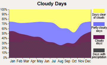
Average climate in Miner, Missouri
Based on data reported by over 4,000 weather stations
Tornado activity:
Miner-area historical tornado activity is slightly above Missouri state average. It is 86% greater than the overall U.S. average.
On 4/22/1981, a category F4 (max. wind speeds 207-260 mph) tornado 11.4 miles away from the Miner city center killed one person and injured 32 people and caused between $5,000,000 and $50,000,000 in damages.
On 5/7/1973, a category F3 (max. wind speeds 158-206 mph) tornado 11.1 miles away from the city center injured 7 people and caused between $50,000 and $500,000 in damages.
Earthquake activity:
Miner-area historical earthquake activity is significantly above Missouri state average. It is 387% greater than the overall U.S. average.On 9/26/1990 at 13:18:51, a magnitude 5.0 (4.7 MB, 4.8 LG, 5.0 LG, Depth: 7.7 mi, Class: Moderate, Intensity: VI - VII) earthquake occurred 19.0 miles away from the city center
On 5/4/1991 at 01:18:54, a magnitude 5.0 (4.4 MB, 4.6 LG, 5.0 LG, Depth: 3.1 mi) earthquake occurred 27.7 miles away from the city center
On 4/18/2008 at 09:36:59, a magnitude 5.4 (5.1 MB, 4.8 MS, 5.4 MW, 5.2 MW) earthquake occurred 140.7 miles away from Miner center
On 3/25/1976 at 00:41:20, a magnitude 5.0 (4.9 MB, 5.0 LG) earthquake occurred 97.4 miles away from the city center
On 4/18/2008 at 09:36:59, a magnitude 5.2 (5.2 MW, Depth: 8.9 mi) earthquake occurred 140.7 miles away from Miner center
On 9/29/1987 at 00:04:56, a magnitude 4.6 (4.6 MB, 4.5 LG, Class: Light, Intensity: IV - V) earthquake occurred 21.2 miles away from Miner center
Magnitude types: regional Lg-wave magnitude (LG), body-wave magnitude (MB), surface-wave magnitude (MS), moment magnitude (MW)
Natural disasters:
The number of natural disasters in Scott County (22) is greater than the US average (15).Major Disasters (Presidential) Declared: 13
Emergencies Declared: 6
Causes of natural disasters: Floods: 14, Storms: 12, Tornadoes: 12, Winter Storms: 5, Winds: 3, Drought: 1, Heavy Rain: 1, Hurricane: 1, Other: 1 (Note: some incidents may be assigned to more than one category).

Hospitals and medical centers in Miner:
Other hospitals and medical centers near Miner:
- SIKESTON JAYCEE REGIONAL DIALYSIS (Dialysis Facility, about 3 miles away; SIKESTON, MO)
- PROVIDENCE HOSPICE GROUP INC (Hospital, about 3 miles away; SIKESTON, MO)
- SIKESTON CONVALESCENT CENTER (Nursing Home, about 3 miles away; SIKESTON, MO)
- CONTINU-CARE (Home Health Center, about 3 miles away; SIKESTON, MO)
- MISSOURI DELTA MEDICAL CENTER Acute Care Hospitals (about 3 miles away; SIKESTON, MO)
- CLEARVIEW NURSING CENTER (Nursing Home, about 4 miles away; SIKESTON, MO)
- SEMO CARE CENTER (Nursing Home, about 4 miles away; SIKESTON, MO)
Colleges/universities with over 2000 students nearest to Miner:
- Southeast Missouri State University (about 30 miles; Cape Girardeau, MO; Full-time enrollment: 9,678)
- West Kentucky Community and Technical College (about 50 miles; Paducah, KY; FT enrollment: 4,107)
- Three Rivers Community College (about 51 miles; Poplar Bluff, MO; FT enrollment: 3,360)
- The University of Tennessee-Martin (about 54 miles; Martin, TN; FT enrollment: 7,013)
- Dyersburg State Community College (about 59 miles; Dyersburg, TN; FT enrollment: 2,211)
- Southern Illinois University-Carbondale (about 60 miles; Carbondale, IL; FT enrollment: 14,539)
- John A Logan College (about 65 miles; Carterville, IL; FT enrollment: 3,995)
Points of interest:
Notable location: Miner Fire Department (A). Display/hide its location on the map
| This city: | 2.4 people |
| Missouri: | 2.5 people |
| This city: | 66.6% |
| Whole state: | 65.3% |
| This city: | 5.7% |
| Whole state: | 6.7% |
Likely homosexual households (counted as self-reported same-sex unmarried-partner households)
- Lesbian couples: 0.8% of all households
- Gay men: 0.3% of all households
3 people in group homes intended for adults in 2010
46 people in nursing homes in 2000
For population 15 years and over in Miner:
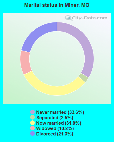
- Never married: 33.6%
- Now married: 31.8%
- Separated: 2.5%
- Widowed: 10.8%
- Divorced: 21.3%
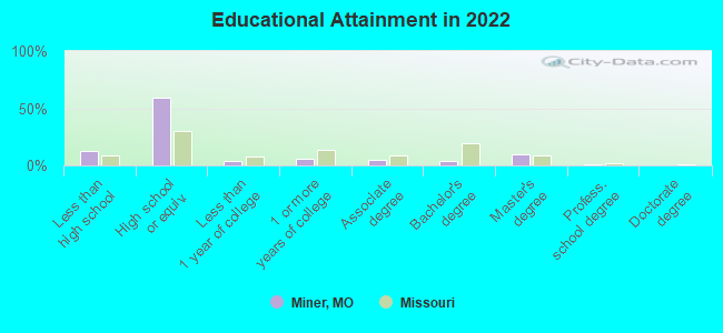
For population 25 years and over in Miner:
- High school or higher: 87.0%
- Bachelor's degree or higher: 13.5%
- Graduate or professional degree: 9.7%
- Unemployed: 5.7%
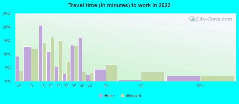
- Mean travel time to work (commute): 16.8 minutes
| Here: | 11.0 |
| Missouri average: | 11.1 |
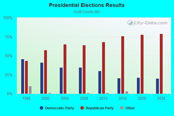
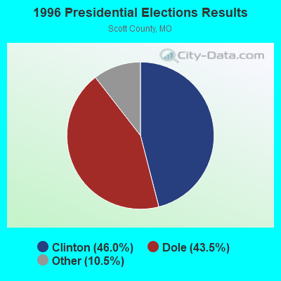
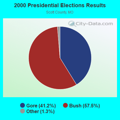

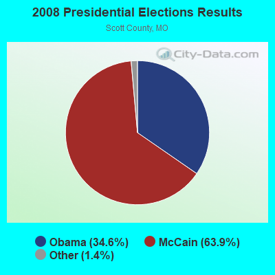
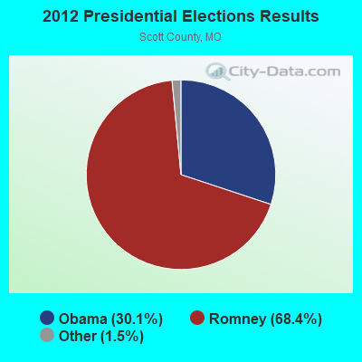

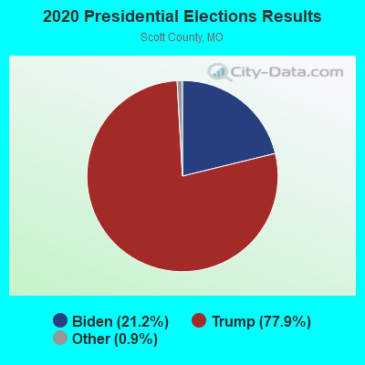
Graphs represent county-level data. Detailed 2008 Election Results
Religion statistics for Miner, MO (based on Scott County data)
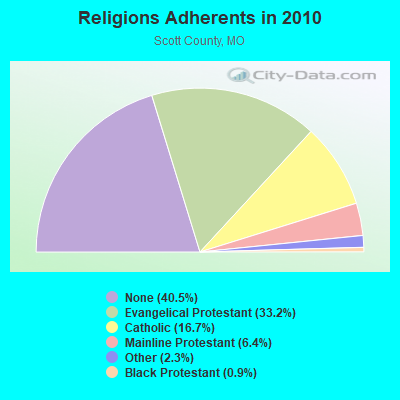
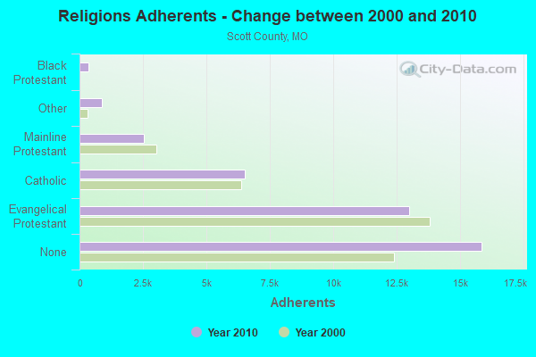
| Religion | Adherents | Congregations |
|---|---|---|
| Evangelical Protestant | 13,017 | 64 |
| Catholic | 6,531 | 7 |
| Mainline Protestant | 2,522 | 14 |
| Other | 891 | 4 |
| Black Protestant | 354 | 3 |
| None | 15,876 | - |
Food Environment Statistics:
| Scott County: | 3.19 / 10,000 pop. |
| Missouri: | 1.88 / 10,000 pop. |
| This county: | 1.97 / 10,000 pop. |
| State: | 0.60 / 10,000 pop. |
| Scott County: | 5.40 / 10,000 pop. |
| State: | 4.34 / 10,000 pop. |
| Here: | 8.60 / 10,000 pop. |
| State: | 7.37 / 10,000 pop. |
| Scott County: | 8.9% |
| Missouri: | 8.8% |
| This county: | 31.5% |
| Missouri: | 29.6% |
| Scott County: | 13.5% |
| State: | 13.5% |
Health and Nutrition:
| Here: | 46.7% |
| State: | 50.9% |
| Miner: | 40.1% |
| State: | 48.6% |
| Miner: | 28.8 |
| Missouri: | 28.7 |
| Here: | 21.1% |
| Missouri: | 20.6% |
| This city: | 12.5% |
| Missouri: | 10.1% |
| Miner: | 6.7 |
| Missouri: | 6.8 |
| Here: | 34.4% |
| Missouri: | 34.3% |
| Miner: | 51.5% |
| Missouri: | 57.5% |
| Miner: | 75.7% |
| Missouri: | 79.3% |
More about Health and Nutrition of Miner, MO Residents
| Local government employment and payroll (March 2022) | |||||
| Function | Full-time employees | Monthly full-time payroll | Average yearly full-time wage | Part-time employees | Monthly part-time payroll |
|---|---|---|---|---|---|
| Police Protection - Officers | 7 | $28,821 | $49,407 | 1 | $1,386 |
| Police - Other | 4 | $14,371 | $43,113 | 1 | $1,687 |
| Other Government Administration | 2 | $8,131 | $48,786 | 1 | $501 |
| Streets and Highways | 1 | $2,963 | $35,556 | 0 | $0 |
| Judicial and Legal | 1 | $3,259 | $39,108 | 3 | $2,930 |
| Sewerage | 1 | $3,658 | $43,896 | 0 | $0 |
| Water Supply | 1 | $5,261 | $63,132 | 0 | $0 |
| Financial Administration | 1 | $2,781 | $33,372 | 1 | $1,109 |
| Other and Unallocable | 0 | $0 | 3 | $1,333 | |
| Firefighters | 0 | $0 | 21 | $2,848 | |
| Totals for Government | 18 | $69,245 | $46,163 | 31 | $11,795 |
Miner government finances - Expenditure in 2021 (per resident):
- Construction - Regular Highways: $125,000 ($138.43)
Water Utilities: $43,000 ($47.62)
Sewerage: $3,000 ($3.32)
- Current Operations - Sewerage: $198,000 ($219.27)
Water Utilities: $190,000 ($210.41)
Police Protection: $139,000 ($153.93)
Local Fire Protection: $113,000 ($125.14)
Regular Highways: $109,000 ($120.71)
Parks and Recreation: $76,000 ($84.16)
Central Staff Services: $62,000 ($68.66)
Solid Waste Management: $50,000 ($55.37)
Financial Administration: $26,000 ($28.79)
General - Other: $13,000 ($14.40)
Judicial and Legal Services: $10,000 ($11.07)
- General - Interest on Debt: $86,000 ($95.24)
- Other Capital Outlay - Water Utilities: $11,000 ($12.18)
Sewerage: $10,000 ($11.07)
Police Protection: $5,000 ($5.54)
Local Fire Protection: $2,000 ($2.21)
- Total Salaries and Wages: $523,000 ($579.18)
- Water Utilities - Interest on Debt: $7,000 ($7.75)
Miner government finances - Revenue in 2021 (per resident):
- Charges - Sewerage: $290,000 ($321.15)
Solid Waste Management: $47,000 ($52.05)
Parks and Recreation: $20,000 ($22.15)
- Local Intergovernmental - Other: $22,000 ($24.36)
- Miscellaneous - Fines and Forfeits: $17,000 ($18.83)
Interest Earnings: $6,000 ($6.64)
- Revenue - Water Utilities: $218,000 ($241.42)
- State Intergovernmental - Highways: $71,000 ($78.63)
Other: $1,000 ($1.11)
- Tax - General Sales and Gross Receipts: $399,000 ($441.86)
Property: $148,000 ($163.90)
Public Utilities Sales: $101,000 ($111.85)
Motor Vehicle License: $9,000 ($9.97)
Other Selective Sales: $9,000 ($9.97)
Tobacco Products Sales: $4,000 ($4.43)
Occupation and Business License - Other: $4,000 ($4.43)
Alcoholic Beverage License: $1,000 ($1.11)
Miner government finances - Debt in 2021 (per resident):
- Long Term Debt - Beginning Outstanding - Unspecified Public Purpose: $2,378,000 ($2633.44)
Outstanding Unspecified Public Purpose: $2,243,000 ($2483.94)
Retired Unspecified Public Purpose: $135,000 ($149.50)
Miner government finances - Cash and Securities in 2021 (per resident):
- Other Funds - Cash and Securities: $764,000 ($846.07)
- Sinking Funds - Cash and Securities: $98,000 ($108.53)
| Businesses in Miner, MO | ||||
| Name | Count | Name | Count | |
|---|---|---|---|---|
| Burger King | 1 | McDonald's | 1 | |
| DressBarn | 1 | Nike | 1 | |
| Dressbarn | 1 | Ruby Tuesday | 1 | |
| Famous Footwear | 1 | Rue21 | 1 | |
Strongest AM radio stations in Miner:
- KRHW (1520 AM; 5 kW; SIKESTON, MO)
- KSIM (1400 AM; 1 kW; SIKESTON, MO; Owner: ZIMMER RADIO OF MID-MISSOURI, INC)
- KZIM (960 AM; 5 kW; CAPE GIRARDEAU, MO; Owner: ZIMMER RADIO OF MID-MISSOURI, INC)
- KAPE (1550 AM; 5 kW; CAPE GIRARDEAU, MO; Owner: W. RUSSELL WITHERS, JR.)
- WCRV (640 AM; 50 kW; COLLIERVILLE, TN; Owner: BOTT BROADCASTING COMPANY/TENNESSEE)
- KCHR (1350 AM; 1 kW; CHARLESTON, MO; Owner: SOUTH MISSOURI B/C COMPANY, INC.)
- KOTC (830 AM; daytime; 10 kW; KENNETT, MO; Owner: EAGLE BLUFF ENTERPRISES)
- WDIA (1070 AM; 50 kW; MEMPHIS, TN; Owner: CLEAR CHANNEL BROADCASTING LICENSES, INC.)
- WGSF (1030 AM; 50 kW; MEMPHIS, TN; Owner: FLINN BROADCASTING CORPORATION)
- KYMO (1080 AM; daytime; 0 kW; EAST PRAIRIE, MO; Owner: USHER BROADCASTING COMPANY)
- KXEN (1010 AM; 50 kW; FESTUS-ST. LOUIS, MO; Owner: BDJ RADIO ENTERPRISES, LLC)
- WSM (650 AM; 50 kW; NASHVILLE, TN; Owner: GAYLORD ENTERTAINMENT COMPANY)
- KMOX (1120 AM; 50 kW; ST. LOUIS, MO; Owner: INFINITY BROADCASTING OPERATIONS, INC.)
Strongest FM radio stations in Miner:
- KBXB (97.9 FM; SIKESTON, MO; Owner: W. RUSSELL WITHERS, JR.)
- KBHI (107.1 FM; MINER, MO; Owner: DANA R WITHERS)
- KWKZ (106.1 FM; CHARLESTON, MO; Owner: ANDERSON BROADCASTING COMPANY, INC.)
- KREZ (104.7 FM; CHAFFEE, MO; Owner: DANA R. WITHERS)
- KGMO (100.7 FM; CAPE GIRARDEAU, MO; Owner: W. RUSSELL WITHERS, JR.)
- WKIB (96.5 FM; ANNA, IL; Owner: W. RUSSELL WITHERS)
- KEZS-FM (102.9 FM; CAPE GIRARDEAU, MO; Owner: ZIMMER BROADCASTING COMPANY, INC.)
- KYMO-FM (105.3 FM; EAST PRAIRIE, MO; Owner: USHER BROADCASTING COMPANY)
- WBEL (88.5 FM; CAIRO, IL; Owner: AMERICAN FAMILY ASSOCIATION)
- KRCU (90.9 FM; CAPE GIRARDEAU, MO; Owner: BOARD OF REGENTS, SOUTHEAST MISSOURI STATE UNIVERSITY)
- KCGQ-FM (99.3 FM; GORDONVILLE, MO; Owner: ZIMMER RADIO OF MID-MISSOURI, INC)
TV broadcast stations around Miner:
- WDKA (Channel 49; PADUCAH, KY; Owner: WDKA ACQUISITION CORPORATION)
- K47FB (Channel 47; CAPE GIRARDEAU, MO; Owner: MS COMMUNICATIONS, LLC)
- K69HT (Channel 69; CAPE GIRARDEAU, MO; Owner: MS COMMUNICATIONS, LLC)
- KFVS-TV (Channel 12; CAPE GIRARDEAU, MO; Owner: RAYCOM AMERICA, INC.)
- KBSI (Channel 23; CAPE GIRARDEAU, MO; Owner: KBSI LICENSEE L.P.)
- WPSD-TV (Channel 6; PADUCAH, KY; Owner: WPSD-TV, LLC)
- K65GP (Channel 65; CAPE GIRARDEAU, MO; Owner: MS COMMUNICATIONS, LLC)
- K58FD (Channel 58; CAPE GIRARDEAU, MO; Owner: MS COMMUNICATIONS, LLC)
- KCGI-CA (Channel 45; CAPE GIRARDEAU, MO; Owner: TRI-STATE CHRISTIAN TV, INC.)
- Miner, Missouri
- Fatal accident count15
- Vehicles involved in fatal accidents22
- Fatal accidents involving drunk persons:8
- Fatalities15
- Persons involved in fatal accidents33
- Pedestrians involved in fatal accidents2
- Missouri average
- Fatal accident count14276
- Vehicles involved in fatal accidents21440
- Fatal accidents involving drunk persons4208
- Fatalities16197
- Persons involved in fatal accidents36160
- Pedestrians involved in fatal accidents1170
- National Bridge Inventory (NBI) Statistics
- 21Number of bridges
- 167ft / 50.8mTotal length
- $393,000Total costs
- 116,443Total average daily traffic
- 34,116Total average daily truck traffic
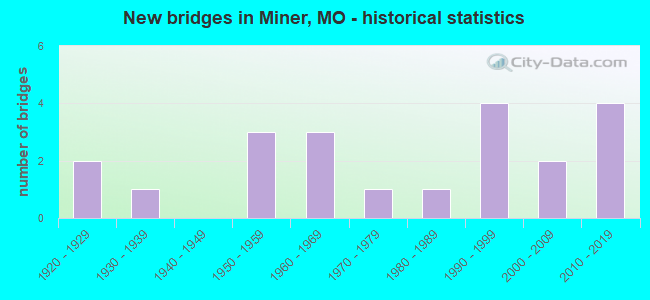
- New bridges - historical statistics
- 21920-1929
- 11930-1939
- 31950-1959
- 31960-1969
- 11970-1979
- 11980-1989
- 41990-1999
- 22000-2009
- 42010-2019
FCC Registered Antenna Towers:
34 (See the full list of FCC Registered Antenna Towers in Miner)FCC Registered Broadcast Land Mobile Towers:
3- 103 H Rd (Lat: 36.884222 Lon: -89.538139), Type: Building, Structure height: 15 m, Call Sign: KNFA361,
Assigned Frequencies: 155.370 MHz, 155.415 MHz, 155.475 MHz, 155.490 MHz, Grant Date: 03/16/2022, Expiration Date: 03/17/2032, Registrant: Federal Licensing Inc, 1588 Fairfield Rd, Gettysburg, PA 17325, Phone: (717) 334-9262, Fax: (717) 334-6440, Email:
- Lat: 36.818083 Lon: -89.524222, Call Sign: WPPA227,
Assigned Frequencies: 451.675 MHz, 451.962 MHz, 452.362 MHz, 452.637 MHz, 456.175 MHz, 456.675 MHz, 456.962 MHz, 457.362 MHz, 457.637 MHz, 452.887 MHz... (+5 more), Grant Date: 07/01/2014, Expiration Date: 09/17/2024, Certifier: David Battles, Registrant: Battles Communications, Inc., 1101 W Bus. Hwy 60, Dexter, MO 63841, Phone: (573) 624-8212, Fax: (573) 624-1983, Email:
- 4.5 Mi S Of Miner On Aa Hwy Then .2 Mi W (Lat: 36.818083 Lon: -89.524222), Type: Tower, Structure height: 92 m, Overall height: 97 m, Call Sign: WQNS248, Licensee ID: L01625041,
Assigned Frequencies: 463.975 MHz, Grant Date: 05/05/2011, Expiration Date: 05/05/2021, Cancellation Date: 07/17/2021, Certifier: Bradley R Nash, Registrant: Conmac Missouri Investments Inc., 412 S Van Buren, Weiner, AR 72479, Phone: (870) 684-7740, Email:
FCC Registered Microwave Towers:
5- Min512, Lat: 36.890056 Lon: -89.522361, Type: Tower, Structure height: 59.7 m, Overall height: 60.6 m, Call Sign: WQHY994,
Assigned Frequencies: 3650.00 MHz, Grant Date: 12/04/2007, Expiration Date: 12/04/2017, Cancellation Date: 02/03/2018, Certifier: Richard Eaton, Registrant: Arent Fox LLP, 1050 Connecticut Avenue, Nw, Washington, DC 20036, Phone: (202) 715-8479, Fax: (202) 857-6395, Email:
- SikeAA2, Lat: 36.818083 Lon: -89.524222, Type: Tower, Structure height: 92 m, Overall height: 97 m, Call Sign: WQOC843,
Assigned Frequencies: 3650.00 MHz, Grant Date: 08/16/2011, Expiration Date: 07/01/2021, Cancellation Date: 07/20/2021, Certifier: David S Battles, Registrant: Battls Xtreme Networks LLC, 821 N Harris Dr, Dexter, MO 63841, Phone: (573) 614-7090, Fax: (573) 625-4047
- SIKAA1, Lat: 36.818083 Lon: -89.524222, Type: Tower, Structure height: 92 m, Overall height: 97 m, Call Sign: WQOC843,
Assigned Frequencies: 3650.00 MHz, Grant Date: 08/16/2011, Expiration Date: 07/01/2021, Cancellation Date: 07/20/2021, Certifier: David S Battles, Registrant: Battls Xtreme Networks LLC, 821 N Harris Dr, Dexter, MO 63841, Phone: (573) 614-7090, Fax: (573) 625-4047
- SKSTMOfoodbank, Lat: 36.899222 Lon: -89.536917, Type: Pipe, Structure height: 8 m, Call Sign: WQRR800,
Assigned Frequencies: 3650.00 MHz, Grant Date: 07/16/2013, Expiration Date: 07/16/2023, Cancellation Date: 12/13/2021, Certifier: Kevin J Keaveny, Registrant: Big River Broadband, 21 S Minnesota Ave, Cape Girardeau, MO 63703, Phone: (573) 651-3373, Fax: (573) 651-1608, Email:
- ST03RW512, 610 David Lane (274053) (Lat: 36.890028 Lon: -89.522389), Type: Gtower, Structure height: 59.7 m, Overall height: 60.4 m, Call Sign: WQVU637,
Assigned Frequencies: 11015.0 MHz, 19375.0 MHz, 11015.0 MHz, 19375.0 MHz, 11015.0 MHz, 19375.0 MHz, 11015.0 MHz, 19375.0 MHz, 11015.0 MHz, 19375.0 MHz... (+6 more), Grant Date: 05/13/2015, Expiration Date: 05/13/2025, Cancellation Date: 05/12/2023, Certifier: David Werblow, Registrant: T-Mobile Usa, Inc., 12920 Se 38th Street, Bellevue, WA 98006, Phone: (425) 383-8401, Email:
FCC Registered Paging Towers:
1- 4.5 Miles South & 5 Miles Of City On Aa Hwy (Lat: 36.819194 Lon: -89.530056), Type: Tower, Structure height: 96.9 m, Call Sign: WRV961,
Assigned Frequencies: 152.240 MHz, Grant Date: 04/23/2019, Expiration Date: 04/01/2029, Certifier: J. Roy Pottle, Registrant: Wilkinson Barker Knauer, LLP, 1800 M Street, N.W., Suite 800n, Washington, DC 20036, Phone: (202) 783-4141, Fax: (202) 783-5851, Email:
2002 - 2018 National Fire Incident Reporting System (NFIRS) incidents
- Fire incident types reported to NFIRS in Miner, MO
- 13846.6%Outside Fires
- 10936.8%Structure Fires
- 4515.2%Mobile Property/Vehicle Fires
- 41.4%Other
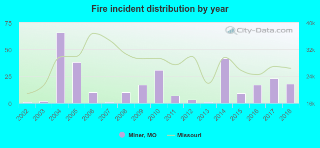 Based on the data from the years 2002 - 2018 the average number of fires per year is 17. The highest number of reported fires - 66 took place in 2004, and the least - 1 in 2002. The data has a growing trend.
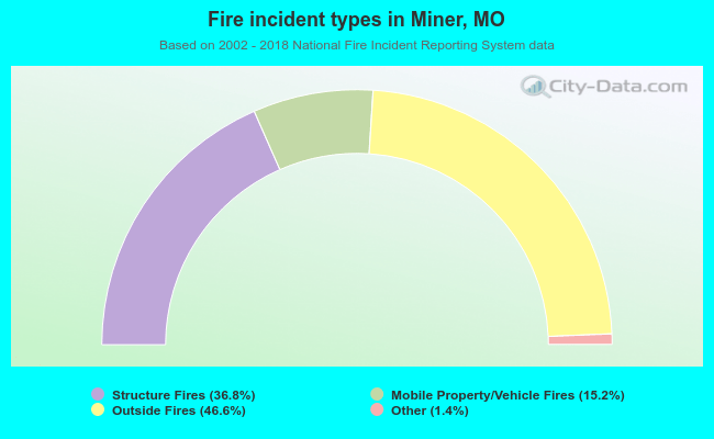 When looking into fire subcategories, the most reports belonged to: Outside Fires (46.6%), and Structure Fires (36.8%).
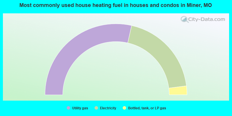
- 57.1%Utility gas
- 38.9%Electricity
- 4.0%Bottled, tank, or LP gas
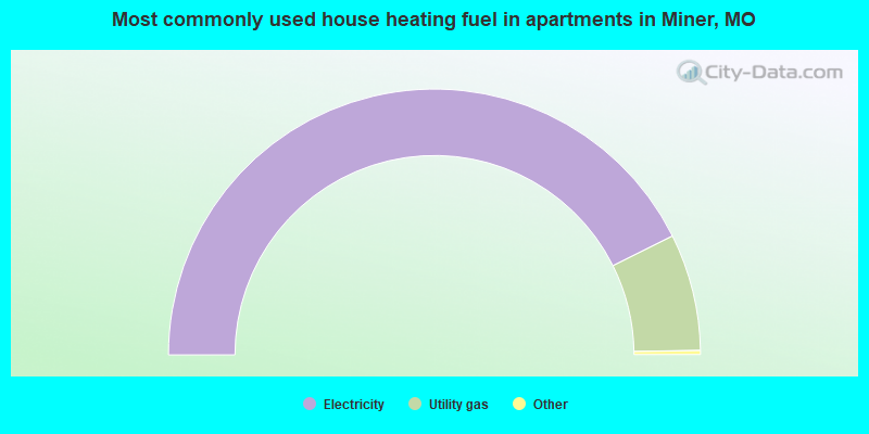
- 85.7%Electricity
- 14.3%Utility gas
Miner compared to Missouri state average:
- Median household income below state average.
- Median house value below state average.
- Unemployed percentage below state average.
- Hispanic race population percentage significantly below state average.
- Median age above state average.
- Foreign-born population percentage significantly below state average.
- Length of stay since moving in significantly below state average.
- Institutionalized population percentage above state average.
- Percentage of population with a bachelor's degree or higher below state average.