Bridge Statistics for Moline, Illinois (IL)
Condition, Traffic, Stress, Structural Evaluation, Project Costs
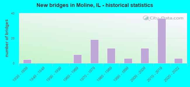
- New bridges - historical statistics
- 31930-1939
- 71960-1969
- 191970-1979
- 121980-1989
- 41990-1999
- 122000-2009
- 362010-2019
- 42020-2022
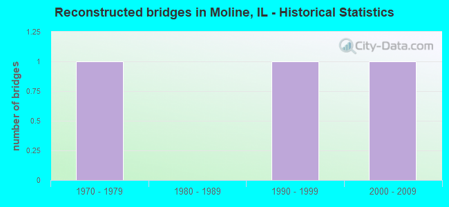
- Reconstructed bridges - Historical Statistics
- 11970-1979
- 01980-1989
- 11990-1999
- 12000-2009
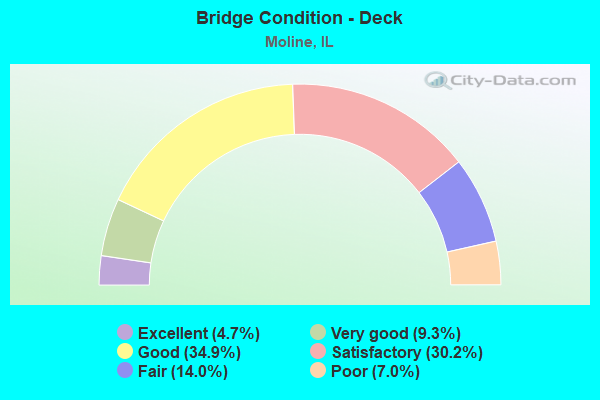
- Bridge Condition - Deck
- 4.7%Excellent
- 9.3%Very good
- 34.9%Good
- 30.2%Satisfactory
- 14.0%Fair
- 7.0%Poor
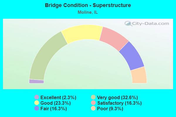
- Bridge Condition - Superstructure
- 2.3%Excellent
- 32.6%Very good
- 23.3%Good
- 16.3%Satisfactory
- 16.3%Fair
- 9.3%Poor
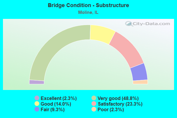
- Bridge Condition - Substructure
- 2.3%Excellent
- 48.8%Very good
- 14.0%Good
- 23.3%Satisfactory
- 9.3%Fair
- 2.3%Poor
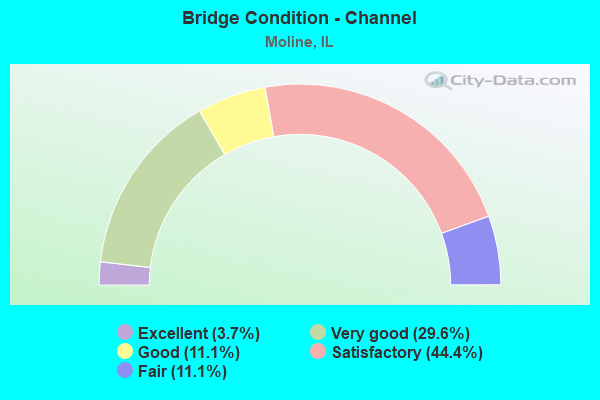
- Bridge Condition - Channel
- 3.7%Excellent
- 29.6%Very good
- 11.1%Good
- 44.4%Satisfactory
- 11.1%Fair
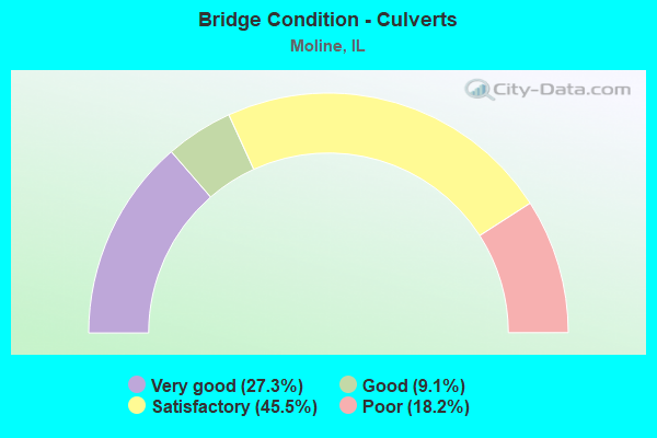
- Bridge Condition - Culverts
- 27.3%Very good
- 9.1%Good
- 45.5%Satisfactory
- 18.2%Poor
Find on map >> Show street view
Structure Number: 810047, Location: S EDGE MOLINE (Lat: 41.462800, Lng: -90.499269), Route carried "on" structure: Other road , Year Built: 1938, Year Reconstructed: 1983, Status: Open, Structure Length: 28.01m (91.90ft), Average Daily Traffic: 11,400 (year 2020), Truck Traffic: 4%, Average Future Daily Traffic: 12,800 (year 2040), Design Load: HS 20+Mod, Features Intersected: ROCK RIVER, SIDE RD, Facility Carried by Structure: 27TH ST - MOLINE
Minimum Vertical Clearance: 30+ m (98+ ft), Kilometerpoint: 5.600, Lanes on structure: 4, Lanes under structure: 2, Base Highway Network: Yes, Owner: State Highway Agency, Approaching Roadway Width: 14.6m (47.9ft), Navigation Control: Yes ( Vertical Clearance: 7.9m (25.9ft), Horizontal Clearance: 47.9m (157.2ft)), Material/Design: Steel continuous, Design/Construction: Stringer/Multi-beam, Number Of Spans In Main Unit: 3, Number Of Approach Spans: 6, Length of Maximum Span: 50.0m (164.0ft), Curb or Sidewalk Widths: Left: 1.2m (3.9ft), Right: 1.2m (3.9ft), Curb-To-Curb Width: 14.8m (48.6ft), Out-to-Out Width: 17.7m (58.1ft)
Condition: Deck: Fair, Superstructure: Poor, Substructure: Satisfactory, Channel: Good, Operating Rating: 54.4 metric tons, Method Used To Determine Operating Rating: Load Factor (LF) rating reported by rating factor (RF) method using MS18 loading, Inventory Rating: 32.4 metric tons, Method Used To Determine Inventory Rating: Load Factor (LF) rating reported by rating factor (RF) method using MS18 loading, Structural Evaluation: Meets minimum limits, Deck Geometry: High priority of replacement, Underclear: Meets minimum limits, Waterway Adequacy: Superior to present desirable criteria, Approach Roadway Alignment: Equal to present desirable criteria, Length Of Structure Improvement: 29.44m (96.59ft), Designated Inspection Frequency: Every 12 months, Underwater Inspection Frequency: Every 24 months, Inspection Date: June 2021, Underwater Inspection Date: June 2020, Bridge Improvement Cost: $7,044,000, Roadway Improvement Cost: $704,000, Total Project Cost: $10,566,000, Deck Structure Type: Concrete Cast-file-Place
Find on map >> Show street view
Structure Number: 810095, Location: S EDGE MOLINE (Lat: 41.471000, Lng: -90.499153), Route carried "on" structure: State highway 5, Year Built: 1966, Status: Open, Structure Length: 4.35m (14.27ft), Average Daily Traffic: 29,100 (year 2021), Truck Traffic: 4%, Average Future Daily Traffic: 26,600 (year 2040), Design Load: HS 20+Mod, Features Intersected: 27TH ST-MOLINE
Minimum Vertical Clearance: 30+ m (98+ ft), Kilometerpoint: 7.274, Lanes on structure: 2, Lanes under structure: 2, Base Highway Network: Yes, Owner: State Highway Agency, Approaching Roadway Width: 17.1m (56.1ft), Material/Design: Steel continuous, Design/Construction: Stringer/Multi-beam, Number Of Spans In Main Unit: 3, Length of Maximum Span: 18.6m (61.0ft), Curb-To-Curb Width: 15.6m (51.2ft), Out-to-Out Width: 16.6m (54.5ft)
Condition: Deck: Satisfactory, Superstructure: Satisfactory, Substructure: Good, Operating Rating: 71.9 metric tons, Method Used To Determine Operating Rating: Load Factor (LF) rating reported by rating factor (RF) method using MS18 loading, Inventory Rating: 43.1 metric tons, Method Used To Determine Inventory Rating: Load Factor (LF) rating reported by rating factor (RF) method using MS18 loading, Structural Evaluation: Equal to present minimum criteria, Deck Geometry: Superior to present desirable criteria, Underclear: High priority of corrective action, Approach Roadway Alignment: Equal to present desirable criteria, Length Of Structure Improvement: 4.33m (14.21ft), Designated Inspection Frequency: Every 24 months, Inspection Date: January 2021, Bridge Improvement Cost: $580,000, Roadway Improvement Cost: $58,000, Total Project Cost: $872,000, Deck Structure Type: Concrete Cast-file-Place, Wearing Surface/Protective System: Deck Protection: Epoxy Coated Reinforcing
Find on map >> Show street view
Structure Number: 810096, Location: S EDGE MOLINE (Lat: 41.471000, Lng: -90.499219), Route carried "on" structure: State highway 5, Year Built: 1966, Status: Open, Structure Length: 4.35m (14.27ft), Average Daily Traffic: 29,100 (year 2021), Truck Traffic: 4%, Average Future Daily Traffic: 6,800 (year 2040), Design Load: HS 20+Mod, Features Intersected: 27TH ST-MOLINE
Minimum Vertical Clearance: 30+ m (98+ ft), Kilometerpoint: 7.258, Lanes on structure: 2, Lanes under structure: 2, Base Highway Network: Yes, Owner: State Highway Agency, Approaching Roadway Width: 17.1m (56.1ft), Material/Design: Steel continuous, Design/Construction: Stringer/Multi-beam, Number Of Spans In Main Unit: 3, Length of Maximum Span: 18.6m (61.0ft), Curb-To-Curb Width: 15.9m (52.2ft), Out-to-Out Width: 16.9m (55.4ft)
Condition: Deck: Satisfactory, Superstructure: Satisfactory, Substructure: Satisfactory, Operating Rating: 78.1 metric tons, Method Used To Determine Operating Rating: Load Factor (LF) rating reported by rating factor (RF) method using MS18 loading, Inventory Rating: 46.7 metric tons, Method Used To Determine Inventory Rating: Load Factor (LF) rating reported by rating factor (RF) method using MS18 loading, Structural Evaluation: Equal to present minimum criteria, Deck Geometry: Superior to present desirable criteria, Underclear: High priority of corrective action, Approach Roadway Alignment: Equal to present desirable criteria, Length Of Structure Improvement: 4.36m (14.30ft), Designated Inspection Frequency: Every 24 months, Inspection Date: January 2021, Bridge Improvement Cost: $158,000, Roadway Improvement Cost: $16,000, Total Project Cost: $190,000, Deck Structure Type: Concrete Cast-file-Place, Wearing Surface/Protective System: Deck Protection: Epoxy Coated Reinforcing
Find on map >> Show street view
Structure Number: 810097, Location: S EDGE MOLINE (Lat: 41.471281, Lng: -90.494561), Route carried "on" structure: State highway 5, Year Built: 1970, Status: Open, Structure Length: 7.21m (23.65ft), Average Daily Traffic: 37,000 (year 2021), Truck Traffic: 5%, Average Future Daily Traffic: 39,100 (year 2040), Design Load: HS 20+Mod, Features Intersected: FAI 74
Minimum Vertical Clearance: 30+ m (98+ ft), Kilometerpoint: 7.660, Lanes on structure: 2, Lanes under structure: 4, Base Highway Network: Yes, Owner: State Highway Agency, Approaching Roadway Width: 16.5m (54.1ft), Skew: 1 degrees, Material/Design: Steel continuous, Design/Construction: Stringer/Multi-beam, Number Of Spans In Main Unit: 4, Length of Maximum Span: 24.4m (80.1ft), Curb-To-Curb Width: 13.1m (43.0ft), Out-to-Out Width: 14.9m (48.9ft)
Condition: Deck: Satisfactory, Superstructure: Poor, Substructure: Satisfactory, Operating Rating: 63.8 metric tons, Method Used To Determine Operating Rating: Load Factor (LF) rating reported by rating factor (RF) method using MS18 loading, Inventory Rating: 33.7 metric tons, Method Used To Determine Inventory Rating: Load Factor (LF) rating reported by rating factor (RF) method using MS18 loading, Structural Evaluation: Meets minimum limits, Deck Geometry: Superior to present desirable criteria, Underclear: High priority of corrective action, Approach Roadway Alignment: Equal to present desirable criteria, Length Of Structure Improvement: 7.22m (23.69ft), Designated Inspection Frequency: Every 12 months, Other Special Inspection Frequency: Every 48 months, Inspection Date: January 2022, Other Special Inspection Date: November 2019, Bridge Improvement Cost: $903,000, Roadway Improvement Cost: $91,000, Total Project Cost: $1,360,000, Deck Structure Type: Concrete Cast-file-Place, Wearing Surface/Protective System: Wearing Surface: Bituminous, Membrane: Built-up
Find on map >> Show street view
Structure Number: 810098, Location: S EDGE MOLINE (Lat: 41.471261, Lng: -90.494819), Route carried "on" structure: State highway 5, Year Built: 1970, Status: Open, Structure Length: 7.21m (23.65ft), Average Daily Traffic: 37,000 (year 2021), Truck Traffic: 5%, Average Future Daily Traffic: 39,100 (year 2040), Design Load: HS 20+Mod, Features Intersected: FAI 74
Minimum Vertical Clearance: 30+ m (98+ ft), Kilometerpoint: 7.628, Lanes on structure: 2, Lanes under structure: 4, Base Highway Network: Yes, Owner: State Highway Agency, Approaching Roadway Width: 16.5m (54.1ft), Skew: 1 degrees, Material/Design: Steel continuous, Design/Construction: Stringer/Multi-beam, Number Of Spans In Main Unit: 4, Length of Maximum Span: 24.5m (80.4ft), Curb-To-Curb Width: 13.1m (43.0ft), Out-to-Out Width: 14.9m (48.9ft)
Condition: Deck: Satisfactory, Superstructure: Fair, Substructure: Fair, Operating Rating: 67.1 metric tons, Method Used To Determine Operating Rating: Load Factor (LF) rating reported by rating factor (RF) method using MS18 loading, Inventory Rating: 35.6 metric tons, Method Used To Determine Inventory Rating: Load Factor (LF) rating reported by rating factor (RF) method using MS18 loading, Structural Evaluation: Somewhat better than minimum adequacy, Deck Geometry: Superior to present desirable criteria, Underclear: High priority of replacement, Approach Roadway Alignment: Equal to present desirable criteria, Length Of Structure Improvement: 7.22m (23.69ft), Designated Inspection Frequency: Every 24 months, Other Special Inspection Frequency: Every 48 months, Inspection Date: January 2022, Other Special Inspection Date: November 2019, Bridge Improvement Cost: $242,000, Roadway Improvement Cost: $24,000, Total Project Cost: $290,000, Deck Structure Type: Concrete Cast-file-Place, Wearing Surface/Protective System: Wearing Surface: Bituminous, Membrane: Built-up
Find on map >> Show street view
Structure Number: 810105, Location: 1.5 MI S ILL 92 (Lat: 41.490772, Lng: -90.504194), Route carried "on" structure: Other road , Year Built: 1970, Status: Open, Structure Length: 6.92m (22.70ft), Average Daily Traffic: 9,000 (year 2020), Truck Traffic: 3%, Average Future Daily Traffic: 18,800 (year 2040), Design Load: HS 20+Mod, Features Intersected: FAI 74, Facility Carried by Structure: 23RD AVE-MOLINE
Minimum Vertical Clearance: 30+ m (98+ ft), Kilometerpoint: 1.255, Lanes on structure: 4, Lanes under structure: 4, Base Highway Network: Yes, Owner: State Highway Agency, Approaching Roadway Width: 26.8m (87.9ft), Skew: 30 degrees, Material/Design: Steel continuous, Design/Construction: Stringer/Multi-beam, Number Of Spans In Main Unit: 2, Number Of Approach Spans: 2, Length of Maximum Span: 24.4m (80.1ft), Curb or Sidewalk Widths: Left: 1.8m (5.9ft), Right: 1.8m (5.9ft), Curb-To-Curb Width: 26.8m (87.9ft), Out-to-Out Width: 36.0m (118.1ft)
Condition: Deck: Fair, Superstructure: Fair, Substructure: Good, Operating Rating: 61.6 metric tons, Method Used To Determine Operating Rating: Allowable Stress (AS) rating reported by rating factor (RF) method using MS18 loading, Inventory Rating: 35.3 metric tons, Method Used To Determine Inventory Rating: Allowable Stress (AS) rating reported by rating factor (RF) method using MS18 loading, Structural Evaluation: Somewhat better than minimum adequacy, Deck Geometry: Superior to present desirable criteria, Underclear: High priority of corrective action, Approach Roadway Alignment: Equal to present desirable criteria, Designated Inspection Frequency: Every 24 months, Inspection Date: December 2021, Deck Structure Type: Concrete Cast-file-Place, Wearing Surface/Protective System: Wearing Surface: Bituminous, Membrane: Built-up
Find on map >> Show street view
Structure Number: 810107, Location: .5 MI S 23RD AVE (Lat: 41.485681, Lng: -90.499719), Route carried "on" structure: Other road , Year Built: 1971, Status: Open, Structure Length: 7.65m (25.10ft), Average Daily Traffic: 1,375 (year 2020), Truck Traffic: 3%, Average Future Daily Traffic: 4,300 (year 2040), Design Load: HS 20+Mod, Features Intersected: FAI 74, Facility Carried by Structure: 27TH ST SB-MOLINE
Minimum Vertical Clearance: 30+ m (98+ ft), Kilometerpoint: 2.736, Lanes on structure: 1, Lanes under structure: 4, Owner: State Highway Agency, Approaching Roadway Width: 7.9m (25.9ft), Skew: 3 degrees, Material/Design: Steel continuous, Design/Construction: Stringer/Multi-beam, Number Of Spans In Main Unit: 2, Number Of Approach Spans: 2, Length of Maximum Span: 26.0m (85.3ft), Curb or Sidewalk Widths: Left: 1.5m (4.9ft), Right: 0.0m, Curb-To-Curb Width: 7.3m (24.0ft), Out-to-Out Width: 10.0m (32.8ft)
Condition: Deck: Satisfactory, Superstructure: Satisfactory, Substructure: Satisfactory, Operating Rating: 60.3 metric tons, Method Used To Determine Operating Rating: Load Factor (LF) rating reported by rating factor (RF) method using MS18 loading, Inventory Rating: 36.0 metric tons, Method Used To Determine Inventory Rating: Load Factor (LF) rating reported by rating factor (RF) method using MS18 loading, Structural Evaluation: Equal to present minimum criteria, Deck Geometry: Meets minimum limits, Underclear: Meets minimum limits, Approach Roadway Alignment: Equal to present desirable criteria, Length Of Structure Improvement: 8.41m (27.59ft), Designated Inspection Frequency: Every 24 months, Inspection Date: December 2020, Bridge Improvement Cost: $1,305,000, Roadway Improvement Cost: $130,000, Total Project Cost: $1,957,000, Deck Structure Type: Concrete Cast-file-Place, Wearing Surface/Protective System: Deck Protection: Epoxy Coated Reinforcing
Find on map >> Show street view
Structure Number: 810108, Location: .6 MI S 23RD AVE (Lat: 41.484311, Lng: -90.498231), Route carried "on" structure: Other road , Year Built: 1971, Status: Open, Structure Length: 7.14m (23.43ft), Average Daily Traffic: 4,600 (year 2015), Truck Traffic: 3%, Average Future Daily Traffic: 6,400 (year 2040), Design Load: HS 20+Mod, Features Intersected: FAI 74, Facility Carried by Structure: 19TH ST NB-MOLINE
Minimum Vertical Clearance: 30+ m (98+ ft), Kilometerpoint: 0.241, Lanes on structure: 2, Lanes under structure: 4, Base Highway Network: Yes (Inventory Route: 95834010, Subroute: 30), Owner: State Highway Agency, Approaching Roadway Width: 9.8m (32.2ft), Skew: 4 degrees, Material/Design: Steel continuous, Design/Construction: Stringer/Multi-beam, Number Of Spans In Main Unit: 2, Number Of Approach Spans: 2, Length of Maximum Span: 37.5m (123.0ft), Curb or Sidewalk Widths: Left: 1.5m (4.9ft), Right: 1.2m (3.9ft), Curb-To-Curb Width: 9.8m (32.2ft), Out-to-Out Width: 12.9m (42.3ft)
Condition: Deck: Good, Superstructure: Satisfactory, Substructure: Satisfactory, Operating Rating: 58.0 metric tons, Method Used To Determine Operating Rating: Allowable Stress (AS) rating reported by rating factor (RF) method using MS18 loading, Inventory Rating: 32.4 metric tons, Method Used To Determine Inventory Rating: Allowable Stress (AS) rating reported by rating factor (RF) method using MS18 loading, Structural Evaluation: Equal to present minimum criteria, Deck Geometry: Meets minimum limits, Underclear: High priority of corrective action, Approach Roadway Alignment: Equal to present desirable criteria, Length Of Structure Improvement: 7.13m (23.39ft), Designated Inspection Frequency: Every 24 months, Inspection Date: December 2020, Bridge Improvement Cost: $811,000, Roadway Improvement Cost: $81,000, Total Project Cost: $1,217,000, Deck Structure Type: Concrete Cast-file-Place, Wearing Surface/Protective System: Deck Protection: Epoxy Coated Reinforcing
Find on map >> Show street view
Structure Number: 810109, Location: S EDGE MOLINE (Lat: 41.475142, Lng: -90.494358), Route carried "on" structure: Interstate 74, Year Built: 1973, Status: Open, Structure Length: 4.56m (14.96ft), Average Daily Traffic: 20,500 (year 2017), Truck Traffic: 9%, Average Future Daily Traffic: 26,900 (year 2040), Design Load: HS 20+Mod, Features Intersected: 36TH AVE - MOLINE
Minimum Vertical Clearance: 30+ m (98+ ft), Kilometerpoint: 6.035, Lanes on structure: 2, Lanes under structure: 2, Base Highway Network: Yes, Owner: State Highway Agency, Approaching Roadway Width: 14.3m (46.9ft), Skew: 2 degrees, Material/Design: Steel continuous, Design/Construction: Stringer/Multi-beam, Number Of Spans In Main Unit: 3, Length of Maximum Span: 19.4m (63.6ft), Curb-To-Curb Width: 14.3m (46.9ft), Out-to-Out Width: 15.3m (50.2ft)
Condition: Deck: Fair, Superstructure: Fair, Substructure: Satisfactory, Operating Rating: 77.1 metric tons, Method Used To Determine Operating Rating: Load Factor (LF) rating reported by rating factor (RF) method using MS18 loading, Inventory Rating: 41.5 metric tons, Method Used To Determine Inventory Rating: Load Factor (LF) rating reported by rating factor (RF) method using MS18 loading, Structural Evaluation: Somewhat better than minimum adequacy, Deck Geometry: Superior to present desirable criteria, Underclear: Superior to present desirable criteria, Approach Roadway Alignment: Equal to present desirable criteria, Designated Inspection Frequency: Every 24 months, Inspection Date: Febuary 2022, Deck Structure Type: Concrete Cast-file-Place, Wearing Surface/Protective System: Wearing Surface: Bituminous, Membrane: Built-up
Find on map >> Show street view
Structure Number: 81011, Location: S EDGE MOLINE (Lat: 41.474994, Lng: -90.494375), Route carried "on" structure: Interstate 74, Year Built: 1973, Status: Open, Structure Length: 4.56m (14.96ft), Average Daily Traffic: 20,500 (year 2017), Truck Traffic: 9%, Average Future Daily Traffic: 29,000 (year 2040), Design Load: HS 20+Mod, Features Intersected: COALTOWN RD-MOLINE
Minimum Vertical Clearance: 30+ m (98+ ft), Kilometerpoint: 6.051, Lanes on structure: 2, Lanes under structure: 2, Base Highway Network: Yes, Owner: State Highway Agency, Approaching Roadway Width: 14.0m (45.9ft), Skew: 2 degrees, Material/Design: Steel continuous, Design/Construction: Stringer/Multi-beam, Number Of Spans In Main Unit: 3, Length of Maximum Span: 19.4m (63.6ft), Curb-To-Curb Width: 13.9m (45.6ft), Out-to-Out Width: 15.0m (49.2ft)
Condition: Deck: Fair, Superstructure: Fair, Substructure: Good, Operating Rating: 72.3 metric tons, Method Used To Determine Operating Rating: Load Factor (LF) rating reported by rating factor (RF) method using MS18 loading, Inventory Rating: 38.9 metric tons, Method Used To Determine Inventory Rating: Load Factor (LF) rating reported by rating factor (RF) method using MS18 loading, Structural Evaluation: Somewhat better than minimum adequacy, Deck Geometry: Superior to present desirable criteria, Underclear: Superior to present desirable criteria, Approach Roadway Alignment: Equal to present desirable criteria, Designated Inspection Frequency: Every 24 months, Inspection Date: Febuary 2022, Deck Structure Type: Concrete Cast-file-Place, Wearing Surface/Protective System: Wearing Surface: Bituminous, Membrane: Built-up
Find on map >> Show street view
Structure Number: 810144, Location: 0.2 MI. E. OF US 150 (Lat: 41.452808, Lng: -90.481867), Route carried "on" structure: US 6, Year Built: 1993, Status: Open, Structure Length: 4.92m (16.14ft), Average Daily Traffic: 9,200 (year 2021), Truck Traffic: 4%, Average Future Daily Traffic: 11,300 (year 2040), Design Load: HS 20, Features Intersected: COAL CREEK
Minimum Vertical Clearance: 30+ m (98+ ft), Kilometerpoint: 11.861, Lanes on structure: 2, Base Highway Network: Yes, Owner: State Highway Agency, Approaching Roadway Width: 13.4m (44.0ft), Material/Design: Steel continuous, Design/Construction: Stringer/Multi-beam, Number Of Spans In Main Unit: 4, Length of Maximum Span: 23.5m (77.1ft), Curb or Sidewalk Widths: Left: 0.0m, Right: 1.5m (4.9ft), Curb-To-Curb Width: 20.1m (65.9ft), Out-to-Out Width: 22.4m (73.5ft)
Condition: Deck: Good, Superstructure: Very good, Substructure: Very good, Channel: Very good, Operating Rating: 72.9 metric tons, Method Used To Determine Operating Rating: Load Factor (LF) rating reported by rating factor (RF) method using MS18 loading, Inventory Rating: 43.4 metric tons, Method Used To Determine Inventory Rating: Load Factor (LF) rating reported by rating factor (RF) method using MS18 loading, Structural Evaluation: Equal to present desirable criteria, Deck Geometry: Superior to present desirable criteria, Waterway Adequacy: Equal to present minimum criteria, Approach Roadway Alignment: Equal to present desirable criteria, Designated Inspection Frequency: Every 48 months, Inspection Date: July 2020, Deck Structure Type: Concrete Cast-file-Place, Wearing Surface/Protective System: Deck Protection: Epoxy Coated Reinforcing
Find on map >> Show street view
Structure Number: 810156, Location: .04MI S JOHN DEER RD (Lat: 41.468042, Lng: -90.536261), Route carried "on" structure: Other road , Year Built: 2006, Status: Open, Structure Length: 6.14m (20.14ft), Average Daily Traffic: 12,100 (year 2020), Truck Traffic: 4%, Average Future Daily Traffic: 58,100 (year 2040), Design Load: HS 20+Mod, Features Intersected: MILAN BELTWAY, Facility Carried by Structure: 52ND AVE
Minimum Vertical Clearance: 30+ m (98+ ft), Kilometerpoint: 0.064, Lanes on structure: 4, Lanes under structure: 4, Base Highway Network: Yes, Owner: State Highway Agency, Approaching Roadway Width: 14.6m (47.9ft), Skew: 31 degrees, Material/Design: Steel continuous, Design/Construction: Stringer/Multi-beam, Number Of Spans In Main Unit: 2, Length of Maximum Span: 27.7m (90.9ft), Curb-To-Curb Width: 20.3m (66.6ft), Out-to-Out Width: 22.3m (73.2ft)
Condition: Deck: Good, Superstructure: Very good, Substructure: Very good, Operating Rating: 71.9 metric tons, Method Used To Determine Operating Rating: Load Factor (LF) rating reported by rating factor (RF) method using MS18 loading, Inventory Rating: 43.1 metric tons, Method Used To Determine Inventory Rating: Load Factor (LF) rating reported by rating factor (RF) method using MS18 loading, Structural Evaluation: Equal to present desirable criteria, Deck Geometry: Equal to present desirable criteria, Underclear: Equal to present minimum criteria, Approach Roadway Alignment: Equal to present desirable criteria, Designated Inspection Frequency: Every 48 months, Inspection Date: October 2020, Deck Structure Type: Concrete Cast-file-Place, Wearing Surface/Protective System: Deck Protection: Epoxy Coated Reinforcing
Find on map >> Show street view
Structure Number: 810159, Location: I74 OVR I280 S OF RR (Lat: 41.458142, Lng: -90.495300), Route carried "on" structure: Interstate 74, Year Built: 2002, Status: Open, Structure Length: 7.20m (23.62ft), Average Daily Traffic: 14,550 (year 2021), Truck Traffic: 8%, Average Future Daily Traffic: 19,500 (year 2040), Design Load: HS 20, Features Intersected: FAI 280
Minimum Vertical Clearance: 30+ m (98+ ft), Kilometerpoint: 7.918, Lanes on structure: 2, Lanes under structure: 4, Base Highway Network: Yes, Owner: State Highway Agency, Approaching Roadway Width: 13.2m (43.3ft), Material/Design: Steel continuous, Design/Construction: Stringer/Multi-beam, Number Of Spans In Main Unit: 2, Length of Maximum Span: 36.2m (118.8ft), Curb-To-Curb Width: 15.0m (49.2ft), Out-to-Out Width: 16.0m (52.5ft)
Condition: Deck: Good, Superstructure: Good, Substructure: Very good, Operating Rating: 80.0 metric tons, Method Used To Determine Operating Rating: Load Factor (LF) rating reported by rating factor (RF) method using MS18 loading, Inventory Rating: 48.0 metric tons, Method Used To Determine Inventory Rating: Load Factor (LF) rating reported by rating factor (RF) method using MS18 loading, Structural Evaluation: Better than present minimum criteria, Deck Geometry: Superior to present desirable criteria, Underclear: Meets minimum limits, Approach Roadway Alignment: Equal to present desirable criteria, Designated Inspection Frequency: Every 24 months, Inspection Date: December 2020, Deck Structure Type: Concrete Cast-file-Place, Wearing Surface/Protective System: Deck Protection: Epoxy Coated Reinforcing
Find on map >> Show street view
Structure Number: 81016, Location: I74 OVR I280S OF RR (Lat: 41.457997, Lng: -90.495294), Route carried "on" structure: Interstate 74, Year Built: 2002, Status: Open, Structure Length: 7.20m (23.62ft), Average Daily Traffic: 14,550 (year 2021), Truck Traffic: 8%, Average Future Daily Traffic: 19,500 (year 2040), Design Load: HS 20, Features Intersected: FAI 280
Minimum Vertical Clearance: 30+ m (98+ ft), Kilometerpoint: 7.934, Lanes on structure: 3, Lanes under structure: 4, Base Highway Network: Yes, Owner: State Highway Agency, Approaching Roadway Width: 13.2m (43.3ft), Material/Design: Steel continuous, Design/Construction: Stringer/Multi-beam, Number Of Spans In Main Unit: 2, Length of Maximum Span: 36.2m (118.8ft), Curb-To-Curb Width: 15.0m (49.2ft), Out-to-Out Width: 16.0m (52.5ft)
Condition: Deck: Satisfactory, Superstructure: Good, Substructure: Very good, Operating Rating: 80.0 metric tons, Method Used To Determine Operating Rating: Load Factor (LF) rating reported by rating factor (RF) method using MS18 loading, Inventory Rating: 48.0 metric tons, Method Used To Determine Inventory Rating: Load Factor (LF) rating reported by rating factor (RF) method using MS18 loading, Structural Evaluation: Better than present minimum criteria, Deck Geometry: Meets minimum limits, Underclear: Equal to present minimum criteria, Approach Roadway Alignment: Equal to present desirable criteria, Designated Inspection Frequency: Every 24 months, Inspection Date: December 2020, Deck Structure Type: Concrete Cast-file-Place, Wearing Surface/Protective System: Deck Protection: Epoxy Coated Reinforcing
Find on map >> Show street view
Structure Number: 810161, Location: S EDGE MOLINE (Lat: 41.461969, Lng: -90.495269), Route carried "on" structure: Interstate 74, Year Built: 2002, Status: Open, Structure Length: 27.08m (88.85ft), Average Daily Traffic: 14,550 (year 2021), Truck Traffic: 8%, Average Future Daily Traffic: 19,500 (year 2040), Design Load: HS 20, Features Intersected: ROCK RIVER, SIDE RDS
Minimum Vertical Clearance: 30+ m (98+ ft), Kilometerpoint: 7.483, Lanes on structure: 2, Base Highway Network: Yes, Owner: State Highway Agency, Approaching Roadway Width: 12.0m (39.4ft), Material/Design: Steel continuous, Design/Construction: Stringer/Multi-beam, Number Of Spans In Main Unit: 7, Length of Maximum Span: 59.5m (195.2ft), Curb-To-Curb Width: 12.0m (39.4ft), Out-to-Out Width: 13.0m (42.7ft)
Condition: Deck: Good, Superstructure: Good, Substructure: Good, Channel: Very good, Operating Rating: 72.9 metric tons, Method Used To Determine Operating Rating: Load Factor (LF) rating reported by rating factor (RF) method using MS18 loading, Inventory Rating: 43.7 metric tons, Method Used To Determine Inventory Rating: Load Factor (LF) rating reported by rating factor (RF) method using MS18 loading, Structural Evaluation: Better than present minimum criteria, Deck Geometry: Equal to present minimum criteria, Waterway Adequacy: Equal to present desirable criteria, Approach Roadway Alignment: Equal to present desirable criteria, Designated Inspection Frequency: Every 24 months, Underwater Inspection Frequency: Every 48 months, Inspection Date: June 2021, Underwater Inspection Date: June 2019, Deck Structure Type: Concrete Cast-file-Place, Wearing Surface/Protective System: Deck Protection: Epoxy Coated Reinforcing
Find on map >> Show street view
Structure Number: 810162, Location: S EDGE MOLINE (Lat: 41.461839, Lng: -90.495269), Route carried "on" structure: Interstate 74, Year Built: 2002, Status: Open, Structure Length: 27.08m (88.85ft), Average Daily Traffic: 14,550 (year 2021), Truck Traffic: 8%, Average Future Daily Traffic: 19,500 (year 2040), Design Load: HS 20, Features Intersected: ROCK RIVER, SIDE RDS
Minimum Vertical Clearance: 30+ m (98+ ft), Kilometerpoint: 7.499, Lanes on structure: 2, Base Highway Network: Yes, Owner: State Highway Agency, Approaching Roadway Width: 12.0m (39.4ft), Material/Design: Steel continuous, Design/Construction: Stringer/Multi-beam, Number Of Spans In Main Unit: 7, Length of Maximum Span: 59.5m (195.2ft), Curb-To-Curb Width: 12.0m (39.4ft), Out-to-Out Width: 13.0m (42.7ft)
Condition: Deck: Satisfactory, Superstructure: Good, Substructure: Good, Channel: Very good, Operating Rating: 80.0 metric tons, Method Used To Determine Operating Rating: Load Factor (LF) rating reported by rating factor (RF) method using MS18 loading, Inventory Rating: 47.6 metric tons, Method Used To Determine Inventory Rating: Load Factor (LF) rating reported by rating factor (RF) method using MS18 loading, Structural Evaluation: Better than present minimum criteria, Deck Geometry: Somewhat better than minimum adequacy, Waterway Adequacy: Equal to present desirable criteria, Approach Roadway Alignment: Equal to present desirable criteria, Designated Inspection Frequency: Every 24 months, Underwater Inspection Frequency: Every 48 months, Inspection Date: June 2021, Underwater Inspection Date: June 2019, Deck Structure Type: Concrete Cast-file-Place, Wearing Surface/Protective System: Deck Protection: Epoxy Coated Reinforcing
Find on map >> Show street view
Structure Number: 810166, Location: S EDGE MOLINE (Lat: 41.457597, Lng: -90.499397), Route carried "on" structure: Other road , Year Built: 2005, Status: Open, Structure Length: 9.69m (31.79ft), Average Daily Traffic: 11,400 (year 2020), Truck Traffic: 4%, Average Future Daily Traffic: 12,800 (year 2040), Design Load: HS 20+Mod, Features Intersected: FAI 280, Facility Carried by Structure: 27TH ST. - MOLINE
Minimum Vertical Clearance: 30+ m (98+ ft), Kilometerpoint: 6.067, Lanes on structure: 4, Lanes under structure: 4, Base Highway Network: Yes, Owner: State Highway Agency, Approaching Roadway Width: 20.7m (67.9ft), Material/Design: Steel, Design/Construction: Stringer/Multi-beam, Number Of Spans In Main Unit: 4, Length of Maximum Span: 31.6m (103.7ft), Curb-To-Curb Width: 20.7m (67.9ft), Out-to-Out Width: 21.7m (71.2ft)
Condition: Deck: Satisfactory, Superstructure: Good, Substructure: Very good, Operating Rating: 89.1 metric tons, Method Used To Determine Operating Rating: Load Factor (LF) rating reported by rating factor (RF) method using MS18 loading, Inventory Rating: 57.3 metric tons, Method Used To Determine Inventory Rating: Load Factor (LF) rating reported by rating factor (RF) method using MS18 loading, Structural Evaluation: Better than present minimum criteria, Deck Geometry: Superior to present desirable criteria, Underclear: Somewhat better than minimum adequacy, Approach Roadway Alignment: Equal to present desirable criteria, Designated Inspection Frequency: Every 24 months, Inspection Date: January 2021, Deck Structure Type: Concrete Cast-file-Place, Wearing Surface/Protective System: Deck Protection: Epoxy Coated Reinforcing
Find on map >> Show street view
Structure Number: 810176, Location: .14MI W OF 38TH ST (Lat: 41.471964, Lng: -90.488092), Route carried "on" structure: City street , Year Built: 2014, Status: Open, Structure Length: 5.68m (18.64ft), Average Daily Traffic: 8,200 (year 2020), Truck Traffic: 4%, Average Future Daily Traffic: 500 (year 2036), Design Load: HS 25 or greater, Features Intersected: IL 5, Facility Carried by Structure: 41ST ST. CONNECTOR
Minimum Vertical Clearance: 30+ m (98+ ft), Kilometerpoint: 0.145, Lanes on structure: 2, Lanes under structure: 5, Owner: State Highway Agency, Approaching Roadway Width: 9.8m (32.2ft), Material/Design: Steel continuous, Design/Construction: Stringer/Multi-beam, Number Of Spans In Main Unit: 2, Length of Maximum Span: 27.5m (90.2ft), Curb or Sidewalk Widths: Left: 0.0m, Right: 3.5m (11.5ft), Curb-To-Curb Width: 9.8m (32.2ft), Out-to-Out Width: 14.2m (46.6ft)
Condition: Deck: Good, Superstructure: Very good, Substructure: Very good, Operating Rating: 60.6 metric tons, Method Used To Determine Operating Rating: Load and Resistance Factor Rating (LRFR) rating reported by rating factor(RF) method using HL-93 loadings, Inventory Rating: 46.7 metric tons, Method Used To Determine Inventory Rating: Load and Resistance Factor Rating (LRFR) rating reported by rating factor(RF) method using HL-93 loadings, Structural Evaluation: Equal to present desirable criteria, Deck Geometry: Meets minimum limits, Underclear: Equal to present minimum criteria, Approach Roadway Alignment: Equal to present desirable criteria, Designated Inspection Frequency: Every 48 months, Inspection Date: December 2020, Deck Structure Type: Concrete Cast-file-Place, Wearing Surface/Protective System: Deck Protection: Epoxy Coated Reinforcing
Find on map >> Show street view
Structure Number: 810177, Location: APPROACH TO MISS RIV (Lat: 41.508042, Lng: -90.508853), Route carried "on" structure: Interstate 74, Year Built: 2019, Status: Open, Structure Length: 59.02m (193.64ft), Average Daily Traffic: 53,000 (year 2021), Truck Traffic: 3%, Average Future Daily Traffic: 58,000 (year 2040), Design Load: HS 25 or greater, Features Intersected: IL 92EB&WB(1-7TH AV)
Minimum Vertical Clearance: 30+ m (98+ ft), Kilometerpoint: 1.770, Lanes on structure: 5, Lanes under structure: 18, Base Highway Network: Yes, Owner: State Highway Agency, Approaching Roadway Width: 18.3m (60.0ft), Skew: 1 degrees, Material/Design: Steel continuous, Design/Construction: Stringer/Multi-beam, Number Of Spans In Main Unit: 11, Length of Maximum Span: 70.1m (230.0ft), Curb-To-Curb Width: 18.3m (60.0ft), Out-to-Out Width: 19.4m (63.6ft)
Condition: Deck: Satisfactory, Superstructure: Very good, Substructure: Very good, Operating Rating: 57.0 metric tons, Method Used To Determine Operating Rating: Load and Resistance Factor Rating (LRFR) rating reported by rating factor(RF) method using HL-93 loadings, Inventory Rating: 44.1 metric tons, Method Used To Determine Inventory Rating: Load and Resistance Factor Rating (LRFR) rating reported by rating factor(RF) method using HL-93 loadings, Structural Evaluation: Equal to present desirable criteria, Deck Geometry: High priority of replacement, Underclear: High priority of corrective action, Approach Roadway Alignment: Equal to present desirable criteria, Designated Inspection Frequency: Every 24 months, Inspection Date: January 2022, Deck Structure Type: Concrete Cast-file-Place, Wearing Surface/Protective System: Deck Protection: Epoxy Coated Reinforcing
Find on map >> Show street view
Structure Number: 810178, Location: APPROACH TO MISS RIV (Lat: 41.508042, Lng: -90.508853), Route carried "on" structure: Interstate 74, Year Built: 2015, Status: Open, Structure Length: 58.89m (193.21ft), Average Daily Traffic: 53,000 (year 2021), Truck Traffic: 3%, Average Future Daily Traffic: 51,900 (year 2040), Design Load: HS 25 or greater, Features Intersected: IL 92EB&WB(1-7TH AV)
Minimum Vertical Clearance: 30+ m (98+ ft), Kilometerpoint: 1.770, Lanes on structure: 5, Lanes under structure: 18, Base Highway Network: Yes, Owner: State Highway Agency, Approaching Roadway Width: 18.3m (60.0ft), Skew: 1 degrees, Material/Design: Steel continuous, Design/Construction: Stringer/Multi-beam, Number Of Spans In Main Unit: 11, Length of Maximum Span: 0.0m, Curb-To-Curb Width: 19.5m (64.0ft), Out-to-Out Width: 20.4m (66.9ft)
Condition: Deck: Satisfactory, Superstructure: Very good, Substructure: Very good, Operating Rating: 48.6 metric tons, Method Used To Determine Operating Rating: Load and Resistance Factor Rating (LRFR) rating reported by rating factor(RF) method using HL-93 loadings, Inventory Rating: 37.6 metric tons, Method Used To Determine Inventory Rating: Load and Resistance Factor Rating (LRFR) rating reported by rating factor(RF) method using HL-93 loadings, Structural Evaluation: Equal to present desirable criteria, Deck Geometry: Meets minimum limits, Approach Roadway Alignment: Equal to present desirable criteria, Designated Inspection Frequency: Every 24 months, Inspection Date: January 2022, Deck Structure Type: Concrete Cast-file-Place, Wearing Surface/Protective System: Deck Protection: Epoxy Coated Reinforcing
Find on map >> Show street view
Structure Number: 810179, Location: 0.5 MI N OF 23RD AVE (Lat: 41.504031, Lng: -90.508417), Route carried "on" structure: Interstate 74, Year Built: 2019, Status: Open, Structure Length: 11.00m (36.09ft), Average Daily Traffic: 26,500 (year 2021), Truck Traffic: 3%, Average Future Daily Traffic: 27,000 (year 2040), Design Load: HS 25 or greater, Features Intersected: 19TH ST-MOLINE
Minimum Vertical Clearance: 30+ m (98+ ft), Kilometerpoint: 2.430, Lanes on structure: 2, Lanes under structure: 4, Base Highway Network: Yes, Owner: State Highway Agency, Approaching Roadway Width: 18.3m (60.0ft), Material/Design: Steel continuous, Design/Construction: Stringer/Multi-beam, Number Of Spans In Main Unit: 3, Length of Maximum Span: 40.8m (133.9ft), Curb-To-Curb Width: 18.3m (60.0ft), Out-to-Out Width: 19.4m (63.6ft)
Condition: Deck: Good, Superstructure: Very good, Substructure: Very good, Operating Rating: 61.6 metric tons, Method Used To Determine Operating Rating: Load and Resistance Factor Rating (LRFR) rating reported by rating factor(RF) method using HL-93 loadings, Inventory Rating: 47.3 metric tons, Method Used To Determine Inventory Rating: Load and Resistance Factor Rating (LRFR) rating reported by rating factor(RF) method using HL-93 loadings, Structural Evaluation: Equal to present desirable criteria, Deck Geometry: Superior to present desirable criteria, Underclear: Meets minimum limits, Approach Roadway Alignment: Equal to present desirable criteria, Designated Inspection Frequency: Every 24 months, Inspection Date: January 2022, Deck Structure Type: Concrete Cast-file-Place, Wearing Surface/Protective System: Deck Protection: Epoxy Coated Reinforcing
Find on map >> Show street view
Structure Number: 81018, Location: 0.5 MI N OF 23RD AVE (Lat: 41.503875, Lng: -90.508425), Route carried "on" structure: Interstate 74, Year Built: 2019, Status: Open, Structure Length: 11.73m (38.48ft), Average Daily Traffic: 26,500 (year 2021), Truck Traffic: 3%, Average Future Daily Traffic: 34,500 (year 2040), Design Load: HS 25 or greater, Features Intersected: 19TH ST-MOLINE
Minimum Vertical Clearance: 30+ m (98+ ft), Kilometerpoint: 2.462, Lanes on structure: 2, Lanes under structure: 4, Base Highway Network: Yes, Owner: State Highway Agency, Approaching Roadway Width: 18.3m (60.0ft), Material/Design: Steel continuous, Number Of Spans In Main Unit: 3, Length of Maximum Span: 0.0m, Curb-To-Curb Width: 18.3m (60.0ft), Out-to-Out Width: 19.2m (63.0ft)
Condition: Deck: Good, Superstructure: Very good, Substructure: Very good, Operating Rating: 60.3 metric tons, Method Used To Determine Operating Rating: Load and Resistance Factor Rating (LRFR) rating reported by rating factor(RF) method using HL-93 loadings, Inventory Rating: 46.3 metric tons, Method Used To Determine Inventory Rating: Load and Resistance Factor Rating (LRFR) rating reported by rating factor(RF) method using HL-93 loadings, Structural Evaluation: Equal to present desirable criteria, Deck Geometry: Superior to present desirable criteria, Approach Roadway Alignment: Equal to present desirable criteria, Designated Inspection Frequency: Every 24 months, Inspection Date: January 2022, Deck Structure Type: Concrete Cast-file-Place, Wearing Surface/Protective System: Deck Protection: Epoxy Coated Reinforcing
Find on map >> Show street view
Structure Number: 810181, Location: 1.1 MI S IOWA LINE (Lat: 41.503050, Lng: -90.508039), Route carried "on" structure: Other road , Year Built: 2019, Status: Open, Structure Length: 9.66m (31.69ft), Average Daily Traffic: 3,250 (year 2015), Truck Traffic: 11%, Average Future Daily Traffic: 4,200 (year 2040), Design Load: HS 25 or greater, Features Intersected: 19TH ST-MOLINE, Facility Carried by Structure: I-74 N.B. OFF RAMP
Minimum Vertical Clearance: 30+ m (98+ ft), Kilometerpoint: 0.113, Lanes on structure: 1, Lanes under structure: 4, Base Highway Network: Yes (Inventory Route: 10074040, Subroute: 20), Owner: State Highway Agency, Approaching Roadway Width: 12.8m (42.0ft), Material/Design: Steel continuous, Design/Construction: Stringer/Multi-beam, Number Of Spans In Main Unit: 3, Length of Maximum Span: 33.5m (109.9ft), Curb-To-Curb Width: 12.8m (42.0ft), Out-to-Out Width: 13.8m (45.3ft)
Condition: Deck: Good, Superstructure: Very good, Substructure: Very good, Operating Rating: 72.9 metric tons, Method Used To Determine Operating Rating: Load and Resistance Factor Rating (LRFR) rating reported by rating factor(RF) method using HL-93 loadings, Inventory Rating: 56.1 metric tons, Method Used To Determine Inventory Rating: Load and Resistance Factor Rating (LRFR) rating reported by rating factor(RF) method using HL-93 loadings, Structural Evaluation: Equal to present desirable criteria, Deck Geometry: Equal to present minimum criteria, Underclear: Meets minimum limits, Approach Roadway Alignment: Equal to present desirable criteria, Designated Inspection Frequency: Every 24 months, Inspection Date: January 2022, Deck Structure Type: Concrete Cast-file-Place, Wearing Surface/Protective System: Deck Protection: Epoxy Coated Reinforcing
Find on map >> Show street view
Structure Number: 810182, Location: 0.7 MI N OF 23RD AVE (Lat: 41.500317, Lng: -90.507969), Route carried "on" structure: Interstate 74, Year Built: 2019, Status: Open, Structure Length: 2.50m (8.20ft), Average Daily Traffic: 26,500 (year 2018), Truck Traffic: 3%, Average Future Daily Traffic: 33,600 (year 2040), Design Load: HS 25 or greater, Features Intersected: 12TH AVE-MOLINE
Minimum Vertical Clearance: 30+ m (98+ ft), Kilometerpoint: 2.929, Lanes on structure: 2, Lanes under structure: 2, Base Highway Network: Yes, Owner: State Highway Agency, Approaching Roadway Width: 21.9m (71.9ft), Skew: 1 degrees, Material/Design: Steel, Design/Construction: Stringer/Multi-beam, Number Of Spans In Main Unit: 1, Length of Maximum Span: 22.9m (75.1ft), Curb-To-Curb Width: 21.9m (71.9ft), Out-to-Out Width: 23.0m (75.5ft)
Condition: Deck: Very good, Superstructure: Very good, Substructure: Very good, Operating Rating: 60.3 metric tons, Method Used To Determine Operating Rating: Load and Resistance Factor Rating (LRFR) rating reported by rating factor(RF) method using HL-93 loadings, Inventory Rating: 46.3 metric tons, Method Used To Determine Inventory Rating: Load and Resistance Factor Rating (LRFR) rating reported by rating factor(RF) method using HL-93 loadings, Structural Evaluation: Equal to present desirable criteria, Deck Geometry: Superior to present desirable criteria, Underclear: Equal to present minimum criteria, Approach Roadway Alignment: Equal to present desirable criteria, Designated Inspection Frequency: Every 24 months, Inspection Date: January 2022, Deck Structure Type: Concrete Cast-file-Place, Wearing Surface/Protective System: Deck Protection: Epoxy Coated Reinforcing
Find on map >> Show street view
Structure Number: 810183, Location: 0.7 MI N OF 23RD AVE (Lat: 41.500411, Lng: -90.508014), Route carried "on" structure: Interstate 74, Year Built: 2020, Status: Open, Structure Length: 2.50m (8.20ft), Average Daily Traffic: 26,500 (year 2018), Truck Traffic: 3%, Average Future Daily Traffic: 34,500 (year 2040), Design Load: HS 25 or greater, Features Intersected: 12TH AVE-MOLINE
Minimum Vertical Clearance: 30+ m (98+ ft), Kilometerpoint: 2.913, Lanes on structure: 3, Lanes under structure: 2, Base Highway Network: Yes, Owner: State Highway Agency, Approaching Roadway Width: 21.9m (71.9ft), Skew: 1 degrees, Material/Design: Steel, Design/Construction: Stringer/Multi-beam, Number Of Spans In Main Unit: 1, Length of Maximum Span: 22.9m (75.1ft), Curb-To-Curb Width: 21.9m (71.9ft), Out-to-Out Width: 23.0m (75.5ft)
Condition: Deck: Very good, Superstructure: Very good, Substructure: Very good, Operating Rating: 59.9 metric tons, Method Used To Determine Operating Rating: Load and Resistance Factor Rating (LRFR) rating reported by rating factor(RF) method using HL-93 loadings, Inventory Rating: 46.0 metric tons, Method Used To Determine Inventory Rating: Load and Resistance Factor Rating (LRFR) rating reported by rating factor(RF) method using HL-93 loadings, Structural Evaluation: Equal to present desirable criteria, Deck Geometry: Superior to present desirable criteria, Approach Roadway Alignment: Equal to present desirable criteria, Designated Inspection Frequency: Every 24 months, Inspection Date: January 2022, Deck Structure Type: Concrete Cast-file-Place, Wearing Surface/Protective System: Deck Protection: Epoxy Coated Reinforcing
Find on map >> Show street view
Structure Number: 810184, Location: .2 MI N 23RD AVE (Lat: 41.493750, Lng: -90.506331), Route carried "on" structure: Interstate 74, Year Built: 2019, Status: Open, Structure Length: 7.92m (25.98ft), Average Daily Traffic: 26,500 (year 2018), Truck Traffic: 3%, Average Future Daily Traffic: 36,000 (year 2040), Design Load: HS 25 or greater, Features Intersected: 19TH ST S.B.-MOLINE
Minimum Vertical Clearance: 30+ m (98+ ft), Kilometerpoint: 3.605, Lanes on structure: 2, Lanes under structure: 2, Base Highway Network: Yes, Owner: State Highway Agency, Approaching Roadway Width: 22.6m (74.1ft), Skew: 5 degrees, Material/Design: Steel continuous, Design/Construction: Stringer/Multi-beam, Number Of Spans In Main Unit: 3, Length of Maximum Span: 29.2m (95.8ft), Curb-To-Curb Width: 22.6m (74.1ft), Out-to-Out Width: 23.6m (77.4ft)
Condition: Deck: Good, Superstructure: Very good, Substructure: Very good, Operating Rating: 54.8 metric tons, Method Used To Determine Operating Rating: Load and Resistance Factor Rating (LRFR) rating reported by rating factor(RF) method using HL-93 loadings, Inventory Rating: 42.1 metric tons, Method Used To Determine Inventory Rating: Load and Resistance Factor Rating (LRFR) rating reported by rating factor(RF) method using HL-93 loadings, Structural Evaluation: Equal to present desirable criteria, Deck Geometry: Superior to present desirable criteria, Underclear: Meets minimum limits, Approach Roadway Alignment: Equal to present desirable criteria, Designated Inspection Frequency: Every 24 months, Inspection Date: January 2022, Deck Structure Type: Concrete Cast-file-Place, Wearing Surface/Protective System: Deck Protection: Epoxy Coated Reinforcing
Find on map >> Show street view
Structure Number: 810185, Location: .2 MI S 23RD AVE (Lat: 41.493594, Lng: -90.506264), Route carried "on" structure: Interstate 74, Year Built: 2019, Status: Open, Structure Length: 7.92m (25.98ft), Average Daily Traffic: 26,500 (year 2018), Truck Traffic: 3%, Average Future Daily Traffic: 34,500 (year 2040), Design Load: HS 25 or greater, Features Intersected: 19TH ST S.B.-MOLINE
Minimum Vertical Clearance: 30+ m (98+ ft), Kilometerpoint: 3.637, Lanes on structure: 2, Lanes under structure: 2, Base Highway Network: Yes, Owner: State Highway Agency, Approaching Roadway Width: 19.5m (64.0ft), Skew: 5 degrees, Material/Design: Steel continuous, Design/Construction: Stringer/Multi-beam, Number Of Spans In Main Unit: 3, Length of Maximum Span: 29.2m (95.8ft), Curb-To-Curb Width: 20.2m (66.3ft), Out-to-Out Width: 21.2m (69.6ft)
Condition: Deck: Good, Superstructure: Very good, Substructure: Very good, Operating Rating: 54.4 metric tons, Method Used To Determine Operating Rating: Load and Resistance Factor Rating (LRFR) rating reported by rating factor(RF) method using HL-93 loadings, Inventory Rating: 42.1 metric tons, Method Used To Determine Inventory Rating: Load and Resistance Factor Rating (LRFR) rating reported by rating factor(RF) method using HL-93 loadings, Structural Evaluation: Equal to present desirable criteria, Deck Geometry: Superior to present desirable criteria, Approach Roadway Alignment: Equal to present desirable criteria, Designated Inspection Frequency: Every 24 months, Inspection Date: January 2022, Deck Structure Type: Concrete Cast-file-Place, Wearing Surface/Protective System: Deck Protection: Epoxy Coated Reinforcing
Find on map >> Show street view
Structure Number: 810186, Location: IN MOLINE (Lat: 41.509908, Lng: -90.509744), Route carried "on" structure: Other road , Year Built: 2020, Status: Open, Structure Length: 12.21m (40.06ft), Average Daily Traffic: 4,000 (year 2021), Average Future Daily Traffic: 4,500 (year 2041), Design Load: HS 25 or greater, Features Intersected: BNSF RR & 4TH AVE, Facility Carried by Structure: RAMP6THC
Minimum Vertical Clearance: 30+ m (98+ ft), Kilometerpoint: 0.177, Lanes on structure: 1, Lanes under structure: 2, Owner: State Highway Agency, Approaching Roadway Width: 9.1m (29.9ft), Skew: 2 degrees, Material/Design: Steel continuous, Design/Construction: Stringer/Multi-beam, Number Of Spans In Main Unit: 2, Length of Maximum Span: 61.6m (202.1ft), Curb-To-Curb Width: 9.1m (29.9ft), Out-to-Out Width: 10.3m (33.8ft)
Condition: Deck: Excellent, Superstructure: Excellent, Substructure: Excellent, Operating Rating: 97.2 metric tons, Method Used To Determine Operating Rating: Load and Resistance Factor Rating (LRFR) rating reported by rating factor(RF) method using HL-93 loadings, Inventory Rating: 46.0 metric tons, Method Used To Determine Inventory Rating: Load and Resistance Factor Rating (LRFR) rating reported by rating factor(RF) method using HL-93 loadings, Structural Evaluation: Superior to present desirable criteria, Deck Geometry: Meets minimum limits, Approach Roadway Alignment: Equal to present desirable criteria, Designated Inspection Frequency: Every 24 months, Inspection Date: August 2021, Deck Structure Type: Concrete Cast-file-Place, Wearing Surface/Protective System: Deck Protection: Epoxy Coated Reinforcing
Find on map >> Show street view
Structure Number: 810187, Location: .75 mi S of Iowa Sta (Lat: 41.507806, Lng: -90.508797), Route carried "on" structure: Interstate 74, Year Built: 2019, Status: Open, Structure Length: 15.39m (50.49ft), Average Daily Traffic: 26,500 (year 2021), Truck Traffic: 3%, Average Future Daily Traffic: 5,500 (year 2040), Design Load: HS 25 or greater, Features Intersected: BNSF RR & 4TH AVE, Facility Carried by Structure: RAMP 6TH D
Minimum Vertical Clearance: 30+ m (98+ ft), Kilometerpoint: 1.786, Lanes on structure: 1, Lanes under structure: 2, Base Highway Network: Yes, Owner: State Highway Agency, Approaching Roadway Width: 9.1m (29.9ft), Skew: 1 degrees, Material/Design: Steel continuous, Design/Construction: Stringer/Multi-beam, Number Of Spans In Main Unit: 3, Length of Maximum Span: 52.6m (172.6ft), Curb-To-Curb Width: 9.1m (29.9ft), Out-to-Out Width: 10.1m (33.1ft)
Condition: Deck: Satisfactory, Superstructure: Very good, Substructure: Very good, Operating Rating: 51.2 metric tons, Method Used To Determine Operating Rating: Load and Resistance Factor Rating (LRFR) rating reported by rating factor(RF) method using HL-93 loadings, Inventory Rating: 39.5 metric tons, Method Used To Determine Inventory Rating: Load and Resistance Factor Rating (LRFR) rating reported by rating factor(RF) method using HL-93 loadings, Structural Evaluation: Equal to present desirable criteria, Deck Geometry: Meets minimum limits, Underclear: Meets minimum limits, Approach Roadway Alignment: Equal to present desirable criteria, Designated Inspection Frequency: Every 24 months, Inspection Date: April 2021, Deck Structure Type: Concrete Cast-file-Place, Wearing Surface/Protective System: Deck Protection: Epoxy Coated Reinforcing
Find on map >> Show street view
Structure Number: 810194, Location: 2.5 MI W HENRY CO (Lat: 41.454489, Lng: -90.481139), Route carried "on" structure: Interstate 74, Year Built: 2014, Status: Open, Structure Length: 3.57m (11.71ft), Average Daily Traffic: 8,150 (year 2021), Truck Traffic: 31%, Average Future Daily Traffic: 7,200 (year 2032), Design Load: HS 25 or greater, Features Intersected: COAL CREEK
Minimum Vertical Clearance: 30+ m (98+ ft), Kilometerpoint: 9.237, Lanes on structure: 2, Base Highway Network: Yes, Owner: State Highway Agency, Approaching Roadway Width: 12.8m (42.0ft), Material/Design: Steel, Design/Construction: Stringer/Multi-beam, Number Of Spans In Main Unit: 3, Length of Maximum Span: 13.1m (43.0ft), Curb-To-Curb Width: 13.0m (42.7ft), Out-to-Out Width: 13.9m (45.6ft)
Condition: Deck: Good, Superstructure: Good, Substructure: Very good, Channel: Very good, Operating Rating: 72.3 metric tons, Method Used To Determine Operating Rating: Load and Resistance Factor Rating (LRFR) rating reported by rating factor(RF) method using HL-93 loadings, Inventory Rating: 53.8 metric tons, Method Used To Determine Inventory Rating: Load and Resistance Factor Rating (LRFR) rating reported by rating factor(RF) method using HL-93 loadings, Structural Evaluation: Better than present minimum criteria, Deck Geometry: Superior to present desirable criteria, Waterway Adequacy: Equal to present desirable criteria, Approach Roadway Alignment: Equal to present desirable criteria, Designated Inspection Frequency: Every 24 months, Inspection Date: December 2020, Deck Structure Type: Concrete Cast-file-Place, Wearing Surface/Protective System: Deck Protection: Epoxy Coated Reinforcing
Find on map >> Show street view
Structure Number: 810195, Location: 2.5 MI W HENRY CO (Lat: 41.454422, Lng: -90.480822), Route carried "on" structure: Interstate 74, Year Built: 2014, Status: Open, Structure Length: 3.57m (11.71ft), Average Daily Traffic: 8,150 (year 2021), Truck Traffic: 31%, Average Future Daily Traffic: 7,200 (year 2032), Design Load: HS 25 or greater, Features Intersected: COAL CREEK
Minimum Vertical Clearance: 30+ m (98+ ft), Kilometerpoint: 9.253, Lanes on structure: 2, Base Highway Network: Yes, Owner: State Highway Agency, Approaching Roadway Width: 12.8m (42.0ft), Material/Design: Steel, Design/Construction: Stringer/Multi-beam, Number Of Spans In Main Unit: 3, Number Of Approach Spans: 2, Length of Maximum Span: 13.1m (43.0ft), Curb-To-Curb Width: 13.0m (42.7ft), Out-to-Out Width: 13.9m (45.6ft)
Condition: Deck: Good, Superstructure: Good, Substructure: Very good, Channel: Very good, Operating Rating: 72.3 metric tons, Method Used To Determine Operating Rating: Load and Resistance Factor Rating (LRFR) rating reported by rating factor(RF) method using HL-93 loadings, Inventory Rating: 53.8 metric tons, Method Used To Determine Inventory Rating: Load and Resistance Factor Rating (LRFR) rating reported by rating factor(RF) method using HL-93 loadings, Structural Evaluation: Better than present minimum criteria, Deck Geometry: Superior to present desirable criteria, Waterway Adequacy: Equal to present desirable criteria, Approach Roadway Alignment: Equal to present desirable criteria, Designated Inspection Frequency: Every 24 months, Inspection Date: December 2020, Deck Structure Type: Concrete Cast-file-Place, Wearing Surface/Protective System: Deck Protection: Epoxy Coated Reinforcing
Find on map >> Show street view
Structure Number: 81112, Location: .16MI E 41ST ST. (Lat: 41.470369, Lng: -90.472719), Route carried "on" structure: State highway 5, Year Built: 2012, Status: Open, Structure Length: 0.72m (2.36ft), Average Daily Traffic: 28,800 (year 2021), Truck Traffic: 7%, Average Future Daily Traffic: 50,100 (year 2039), Design Load: HS 25 or greater, Features Intersected: CREEK
Minimum Vertical Clearance: 30+ m (98+ ft), Kilometerpoint: 9.527, Lanes on structure: 4, Base Highway Network: Yes, Owner: State Highway Agency, Approaching Roadway Width: 21.9m (71.9ft), Material/Design: Concrete, Design/Construction: Culvert, Number Of Spans In Main Unit: 2, Length of Maximum Span: 3.5m (11.5ft)
Condition: Channel: Good, Culverts: Good, Operating Rating: 53.8 metric tons, Method Used To Determine Operating Rating: Load and Resistance Factor Rating (LRFR) rating reported by rating factor(RF) method using HL-93 loadings, Inventory Rating: 41.5 metric tons, Method Used To Determine Inventory Rating: Load and Resistance Factor Rating (LRFR) rating reported by rating factor(RF) method using HL-93 loadings, Structural Evaluation: Better than present minimum criteria, Waterway Adequacy: Equal to present desirable criteria, Approach Roadway Alignment: Equal to present desirable criteria, Designated Inspection Frequency: Every 48 months, Inspection Date: December 2020
Find on map >> Show street view
Structure Number: 812015, Location: .2 MI W 16TH ST MOL. (Lat: 41.471308, Lng: -90.511914), Route carried "on" structure: State highway 5, Year Built: 1987, Status: Open, Structure Length: 0.72m (2.36ft), Average Daily Traffic: 27,000 (year 2021), Truck Traffic: 5%, Average Future Daily Traffic: 21,400 (year 2040), Design Load: HS 20, Features Intersected: UNNAMED STREAM
Minimum Vertical Clearance: 30+ m (98+ ft), Kilometerpoint: 6.228, Lanes on structure: 6, Base Highway Network: Yes, Owner: State Highway Agency, Approaching Roadway Width: 29.9m (98.1ft), Skew: 20 degrees, Material/Design: Concrete, Design/Construction: Culvert, Number Of Spans In Main Unit: 2, Length of Maximum Span: 3.5m (11.5ft)
Condition: Channel: Good, Culverts: Satisfactory, Operating Rating: 57.7 metric tons, Method Used To Determine Operating Rating: Load Factor (LF) rating reported by rating factor (RF) method using MS18 loading, Inventory Rating: 34.3 metric tons, Method Used To Determine Inventory Rating: Load Factor (LF) rating reported by rating factor (RF) method using MS18 loading, Structural Evaluation: Equal to present minimum criteria, Waterway Adequacy: Equal to present desirable criteria, Approach Roadway Alignment: Equal to present desirable criteria, Designated Inspection Frequency: Every 24 months, Inspection Date: December 2020
Find on map >> Show street view
Structure Number: 812016, Location: .4MI E 7TH ST MOLINE (Lat: 41.471322, Lng: -90.520425), Route carried "on" structure: State highway 5, Year Built: 1987, Status: Open, Structure Length: 0.98m (3.22ft), Average Daily Traffic: 27,000 (year 2021), Truck Traffic: 5%, Average Future Daily Traffic: 42,800 (year 2040), Design Load: HS 20, Features Intersected: STREAM
Minimum Vertical Clearance: 30+ m (98+ ft), Kilometerpoint: 5.504, Lanes on structure: 6, Base Highway Network: Yes, Owner: State Highway Agency, Approaching Roadway Width: 28.7m (94.2ft), Skew: 10 degrees, Material/Design: Concrete, Design/Construction: Culvert, Number Of Spans In Main Unit: 3, Length of Maximum Span: 3.2m (10.5ft)
Condition: Channel: Satisfactory, Culverts: Satisfactory, Operating Rating: 71.3 metric tons, Method Used To Determine Operating Rating: Load Factor (LF) rating reported by rating factor (RF) method using MS18 loading, Inventory Rating: 42.4 metric tons, Method Used To Determine Inventory Rating: Load Factor (LF) rating reported by rating factor (RF) method using MS18 loading, Structural Evaluation: Equal to present minimum criteria, Waterway Adequacy: Equal to present desirable criteria, Approach Roadway Alignment: Equal to present desirable criteria, Designated Inspection Frequency: Every 24 months, Inspection Date: December 2020
Find on map >> Show street view
Structure Number: 812017, Location: .25 MI E 44TH ST-R I (Lat: 41.469853, Lng: -90.536583), Route carried "on" structure: City street , Year Built: 1988, Status: Open, Structure Length: 0.72m (2.36ft), Average Daily Traffic: 3,400 (year 2020), Truck Traffic: 4%, Average Future Daily Traffic: 2,800 (year 2040), Design Load: HS 20, Features Intersected: UNNAMED STREAM, Facility Carried by Structure: Municipal St.
Minimum Vertical Clearance: 30+ m (98+ ft), Kilometerpoint: 0.161, Lanes on structure: 4, Owner: State Highway Agency, Approaching Roadway Width: 7.9m (25.9ft), Skew: 12 degrees, Material/Design: Concrete, Design/Construction: Culvert, Number Of Spans In Main Unit: 2, Length of Maximum Span: 3.5m (11.5ft)
Condition: Channel: Fair, Culverts: Satisfactory, Operating Rating: 69.3 metric tons, Method Used To Determine Operating Rating: Load Factor (LF) rating reported by rating factor (RF) method using MS18 loading, Inventory Rating: 41.5 metric tons, Method Used To Determine Inventory Rating: Load Factor (LF) rating reported by rating factor (RF) method using MS18 loading, Structural Evaluation: Equal to present minimum criteria, Waterway Adequacy: Better than present minimum criteria, Approach Roadway Alignment: Equal to present desirable criteria, Designated Inspection Frequency: Every 24 months, Inspection Date: June 2020
Find on map >> Show street view
Structure Number: 812018, Location: .4MI E 7TH ST-MOLINE (Lat: 41.468797, Lng: -90.523031), Route carried "on" structure: City street , Year Built: 1988, Status: Open, Structure Length: 1.55m (5.09ft), Average Daily Traffic: 1,100 (year 2020), Truck Traffic: 10%, Average Future Daily Traffic: 6,100 (year 2040), Design Load: HS 20, Features Intersected: STREAM, Facility Carried by Structure: 43RD AVE
Minimum Vertical Clearance: 30+ m (98+ ft), Kilometerpoint: 0.708, Lanes on structure: 2, Owner: City or Municipal Highway Agency, Approaching Roadway Width: 9.1m (29.9ft), Material/Design: Concrete, Design/Construction: Culvert, Number Of Spans In Main Unit: 4, Length of Maximum Span: 3.7m (12.1ft)
Condition: Channel: Fair, Culverts: Very good, Operating Rating: 44.4 metric tons, Method Used To Determine Operating Rating: Assigned rating based on Load Factor Design (LFD) reported by rating factor (RF) using MS18 loading, Inventory Rating: 32.4 metric tons, Method Used To Determine Inventory Rating: Assigned rating based on Load Factor Design (LFD) reported by rating factor (RF) using MS18 loading, Structural Evaluation: Equal to present desirable criteria, Waterway Adequacy: Superior to present desirable criteria, Approach Roadway Alignment: Superior to present desirable criteria, Designated Inspection Frequency: Every 48 months, Inspection Date: May 2020
Find on map >> Show street view
Structure Number: 81202, Location: .15MI E 16TH ST MOL. (Lat: 41.471086, Lng: -90.503989), Route carried "on" structure: State highway 5, Year Built: 1987, Status: Open, Structure Length: 1.27m (4.17ft), Average Daily Traffic: 29,100 (year 2021), Truck Traffic: 4%, Average Future Daily Traffic: 44,200 (year 2040), Design Load: HS 20, Features Intersected: DRAINAGE DITCH
Minimum Vertical Clearance: 30+ m (98+ ft), Kilometerpoint: 6.888, Lanes on structure: 6, Base Highway Network: Yes, Owner: State Highway Agency, Approaching Roadway Width: 31.7m (104.0ft), Skew: 11 degrees, Material/Design: Concrete, Design/Construction: Culvert, Number Of Spans In Main Unit: 5, Length of Maximum Span: 1.9m (6.2ft)
Condition: Channel: Satisfactory, Culverts: Satisfactory, Operating Rating: 44.1 metric tons, Method Used To Determine Operating Rating: Load Factor (LF) rating reported by rating factor (RF) method using MS18 loading, Inventory Rating: 32.4 metric tons, Method Used To Determine Inventory Rating: Load Factor (LF) rating reported by rating factor (RF) method using MS18 loading, Structural Evaluation: Equal to present minimum criteria, Waterway Adequacy: Equal to present minimum criteria, Approach Roadway Alignment: Equal to present minimum criteria, Designated Inspection Frequency: Every 24 months, Inspection Date: July 2021
Find on map >> Show street view
Structure Number: 812032, Location: 1MI E 70TH ST MOLINE (Lat: 41.469594, Lng: -90.427431), Route carried "on" structure: State highway 5, Year Built: 1999, Status: Open, Structure Length: 0.77m (2.53ft), Average Daily Traffic: 11,000 (year 2021), Truck Traffic: 9%, Average Future Daily Traffic: 14,000 (year 2040), Design Load: HS 20+Mod, Features Intersected: STREAM
Minimum Vertical Clearance: 30+ m (98+ ft), Kilometerpoint: 13.357, Lanes on structure: 4, Base Highway Network: Yes, Owner: State Highway Agency, Approaching Roadway Width: 12.2m (40.0ft), Skew: 10 degrees, Material/Design: Concrete, Design/Construction: Culvert, Number Of Spans In Main Unit: 2, Length of Maximum Span: 3.3m (10.8ft)
Condition: Channel: Satisfactory, Culverts: Very good, Operating Rating: 44.1 metric tons, Method Used To Determine Operating Rating: Load Factor (LF) rating reported by rating factor (RF) method using MS18 loading, Inventory Rating: 32.4 metric tons, Method Used To Determine Inventory Rating: Load Factor (LF) rating reported by rating factor (RF) method using MS18 loading, Structural Evaluation: Equal to present desirable criteria, Waterway Adequacy: Equal to present desirable criteria, Approach Roadway Alignment: Equal to present desirable criteria, Designated Inspection Frequency: Every 48 months, Inspection Date: August 2021
Find on map >> Show street view
Structure Number: 812035, Location: W. OF MILAN BELTWAY (Lat: 41.468239, Lng: -90.536497), Route carried "on" structure: Other road , Year Built: 2006, Status: Open, Structure Length: 0.67m (2.20ft), Average Daily Traffic: 12,100 (year 2020), Truck Traffic: 4%, Average Future Daily Traffic: 16,100 (year 2040), Design Load: HS 20+Mod, Features Intersected: STREAM, Facility Carried by Structure: 52ND AVE
Minimum Vertical Clearance: 30+ m (98+ ft), Kilometerpoint: 0.032, Lanes on structure: 4, Base Highway Network: Yes, Owner: State Highway Agency, Approaching Roadway Width: 19.5m (64.0ft), Material/Design: Concrete, Design/Construction: Culvert, Number Of Spans In Main Unit: 2, Length of Maximum Span: 3.2m (10.5ft)
Condition: Channel: Very good, Culverts: Satisfactory, Operating Rating: 89.1 metric tons, Method Used To Determine Operating Rating: Load Factor (LF) rating reported by rating factor (RF) method using MS18 loading, Inventory Rating: 54.4 metric tons, Method Used To Determine Inventory Rating: Load Factor (LF) rating reported by rating factor (RF) method using MS18 loading, Structural Evaluation: Equal to present minimum criteria, Waterway Adequacy: Equal to present desirable criteria, Approach Roadway Alignment: Equal to present desirable criteria, Designated Inspection Frequency: Every 24 months, Inspection Date: June 2020, Deck Structure Type: Other