Bridge Statistics for Monett, Missouri (MO)
Condition, Traffic, Stress, Structural Evaluation, Project Costs
- National Bridge Inventory (NBI) Statistics
- 48Number of bridges
- 430ft / 131mTotal length
- $3,946,000Total costs
- 78,482Total average daily traffic
- 7,938Total average daily truck traffic
- 141,781Total future (year 2039) average daily traffic
- National Bridge Inventory (NBI) Registered Bridges for Monett
- No street view available for this location
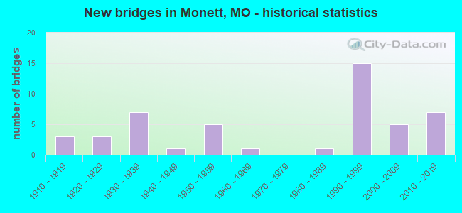
- New bridges - historical statistics
- 31910-1919
- 31920-1929
- 71930-1939
- 11940-1949
- 51950-1959
- 11960-1969
- 11980-1989
- 151990-1999
- 52000-2009
- 72010-2019
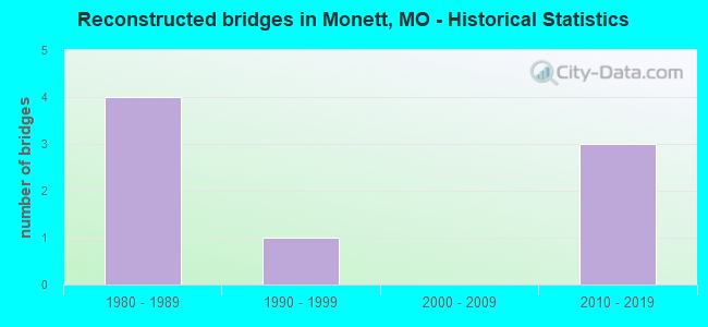
- Reconstructed bridges - Historical Statistics
- 41980-1989
- 11990-1999
- 02000-2009
- 32010-2019
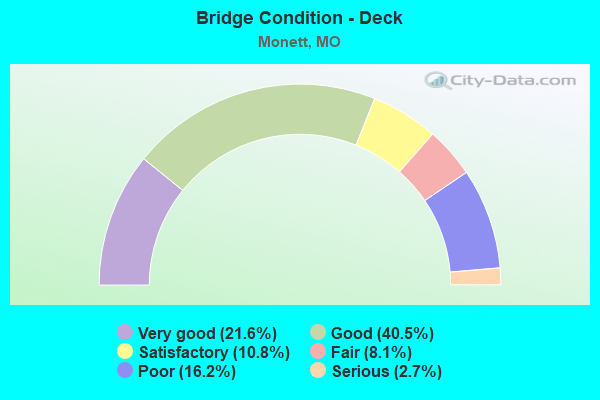
- Bridge Condition - Deck
- 21.6%Very good
- 40.5%Good
- 10.8%Satisfactory
- 8.1%Fair
- 16.2%Poor
- 2.7%Serious
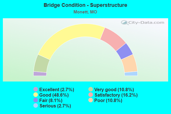
- Bridge Condition - Superstructure
- 2.7%Excellent
- 10.8%Very good
- 48.6%Good
- 16.2%Satisfactory
- 8.1%Fair
- 10.8%Poor
- 2.7%Serious
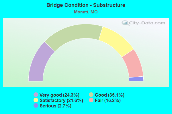
- Bridge Condition - Substructure
- 24.3%Very good
- 35.1%Good
- 21.6%Satisfactory
- 16.2%Fair
- 2.7%Serious
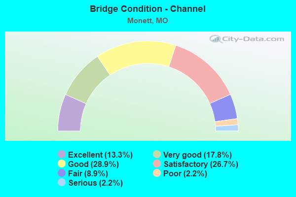
- Bridge Condition - Channel
- 13.3%Excellent
- 17.8%Very good
- 28.9%Good
- 26.7%Satisfactory
- 8.9%Fair
- 2.2%Poor
- 2.2%Serious
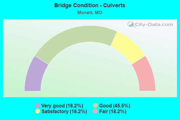
- Bridge Condition - Culverts
- 18.2%Very good
- 45.5%Good
- 18.2%Satisfactory
- 18.2%Fair
Find on map >> Show street view
Structure Number: 511, Location: S 31 T 26 N R 27 W (Lat: 36.915103, Lng: -93.929544), Route carried "on" structure: State highway 37, Year Built: 1929, Year Reconstructed: 2019, Status: Open, Structure Length: 1.62m (5.31ft), Average Daily Traffic: 7,923 (year 2021), Truck Traffic: 9%, Average Future Daily Traffic: 15,450 (year 2041), Design Load: HS 20, Features Intersected: KELLY CR
Minimum Vertical Clearance: 30+ m (98+ ft), Kilometerpoint: 74.178, Lanes on structure: 4, Owner: State Highway Agency, Approaching Roadway Width: 18.3m (60.0ft), Material/Design: Prestressed concrete, Design/Construction: Stringer/Multi-beam, Number Of Spans In Main Unit: 1, Length of Maximum Span: 15.2m (49.9ft), Curb-To-Curb Width: 18.3m (60.0ft), Out-to-Out Width: 19.1m (62.7ft)
Condition: Deck: Good, Superstructure: Good, Substructure: Good, Channel: Good, Operating Rating: 54.9 metric tons, Method Used To Determine Operating Rating: Load Factor (LF), Inventory Rating: 27.0 metric tons, Method Used To Determine Inventory Rating: Load Factor (LF), Structural Evaluation: Equal to present minimum criteria, Deck Geometry: Somewhat better than minimum adequacy, Waterway Adequacy: Equal to present desirable criteria, Approach Roadway Alignment: Equal to present desirable criteria, Designated Inspection Frequency: Every 24 months, Inspection Date: September 2021, Deck Structure Type: Concrete Cast-file-Place, Wearing Surface/Protective System: Wearing Surface: Monolithic Concrete, Deck Protection: Epoxy Coated Reinforcing
Find on map >> Show street view
Structure Number: 6127, Location: S 2 T 25 N R 27 W (Lat: 36.913067, Lng: -93.861503), Route carried "on" structure: US 60, Year Built: 1956, Status: Open, Structure Length: 0.96m (3.15ft), Average Daily Traffic: 10,579 (year 2021), Truck Traffic: 12%, Average Future Daily Traffic: 18,513 (year 2041), Design Load: H 20, Features Intersected: DRY WASH
Minimum Vertical Clearance: 30+ m (98+ ft), Kilometerpoint: 73.182, Lanes on structure: 2, Base Highway Network: Yes, Owner: State Highway Agency, Approaching Roadway Width: 13.4m (44.0ft), Material/Design: Concrete continuous, Design/Construction: Culvert, Number Of Spans In Main Unit: 3, Length of Maximum Span: 3.0m (9.8ft)
Condition: Channel: Good, Culverts: Satisfactory, Operating Rating: 92.7 metric tons, Method Used To Determine Operating Rating: Load Factor (LF), Inventory Rating: 54.9 metric tons, Method Used To Determine Inventory Rating: Load Factor (LF), Structural Evaluation: Equal to present minimum criteria, Waterway Adequacy: Equal to present desirable criteria, Approach Roadway Alignment: Equal to present desirable criteria, Designated Inspection Frequency: Every 24 months, Inspection Date: April 2020
Find on map >> Show street view
Structure Number: 6128, Location: S 31 T 26 N R 27 W (Lat: 36.914567, Lng: -93.922881), Route carried "on" structure: US 60, Year Built: 1956, Year Reconstructed: 2019, Status: Open, Structure Length: 13.05m (42.81ft), Average Daily Traffic: 7,652 (year 2021), Truck Traffic: 11%, Average Future Daily Traffic: 14,921 (year 2041), Design Load: H 20, Features Intersected: AM RR, CLEAR CR
Minimum Vertical Clearance: 30+ m (98+ ft), Kilometerpoint: 480.482, Lanes on structure: 2, Base Highway Network: Yes, Owner: State Highway Agency, Approaching Roadway Width: 9.5m (31.2ft), Material/Design: Steel continuous, Design/Construction: Stringer/Multi-beam, Number Of Spans In Main Unit: 6, Length of Maximum Span: 25.9m (85.0ft), Curb-To-Curb Width: 9.5m (31.2ft), Out-to-Out Width: 10.3m (33.8ft)
Condition: Deck: Very good, Superstructure: Fair, Substructure: Good, Channel: Very good, Operating Rating: 46.8 metric tons, Method Used To Determine Operating Rating: Load Factor (LF), Inventory Rating: 27.9 metric tons, Method Used To Determine Inventory Rating: Load Factor (LF), Structural Evaluation: Somewhat better than minimum adequacy, Deck Geometry: Meets minimum limits, Underclear: Better than present minimum criteria, Waterway Adequacy: Equal to present desirable criteria, Approach Roadway Alignment: Equal to present desirable criteria, Designated Inspection Frequency: Every 24 months, Inspection Date: September 2021, Deck Structure Type: Concrete Cast-file-Place, Wearing Surface/Protective System: Wearing Surface: Monolithic Concrete, Deck Protection: Epoxy Coated Reinforcing
Find on map >> Show street view
Structure Number: 6357, Location: S 17 T 25 N R 28 W (Lat: 36.882819, Lng: -94.012422), Route carried "on" structure: State highway 97, Year Built: 1953, Status: Open, Structure Length: 4.57m (14.99ft), Average Daily Traffic: 732 (year 2021), Truck Traffic: 13%, Average Future Daily Traffic: 1,208 (year 2041), Design Load: H 15, Features Intersected: HUDSON CR
Minimum Vertical Clearance: 30+ m (98+ ft), Kilometerpoint: 112.342, Lanes on structure: 2, Owner: State Highway Agency, Approaching Roadway Width: 6.1m (20.0ft), Material/Design: Concrete, Design/Construction: Tee Beam, Number Of Spans In Main Unit: 4, Length of Maximum Span: 13.0m (42.7ft), Curb-To-Curb Width: 6.7m (22.0ft), Out-to-Out Width: 8.0m (26.2ft)
Condition: Deck: Serious, Superstructure: Serious, Substructure: Satisfactory, Channel: Fair, Operating Rating: 30.6 metric tons, Method Used To Determine Operating Rating: Load Factor (LF), Inventory Rating: 18.9 metric tons, Method Used To Determine Inventory Rating: Load Factor (LF), Structural Evaluation: High priority of corrective action, Deck Geometry: Meets minimum limits, Waterway Adequacy: Equal to present minimum criteria, Approach Roadway Alignment: Somewhat better than minimum adequacy, Length Of Structure Improvement: 0.56m (1.84ft), Designated Inspection Frequency: Every 24 months, Inspection Date: September 2021, Bridge Improvement Cost: $640,000, Roadway Improvement Cost: $64,000, Total Project Cost: $960,000 ( Estimate for 2022), Deck Structure Type: Concrete Cast-file-Place, Wearing Surface/Protective System: Wearing Surface: Bituminous
Find on map >> Show street view
Structure Number: 6358, Location: S 20 T 25 N R 28 W (Lat: 36.868478, Lng: -94.010775), Route carried "on" structure: State highway 97, Year Built: 1953, Status: Open, Structure Length: 3.44m (11.29ft), Average Daily Traffic: 732 (year 2021), Truck Traffic: 13%, Average Future Daily Traffic: 1,208 (year 2041), Design Load: H 15, Features Intersected: CAPPS CR
Minimum Vertical Clearance: 30+ m (98+ ft), Kilometerpoint: 113.998, Lanes on structure: 2, Owner: State Highway Agency, Approaching Roadway Width: 6.1m (20.0ft), Material/Design: Concrete, Design/Construction: Tee Beam, Number Of Spans In Main Unit: 3, Length of Maximum Span: 14.5m (47.6ft), Curb-To-Curb Width: 6.7m (22.0ft), Out-to-Out Width: 8.0m (26.2ft)
Condition: Deck: Poor, Superstructure: Poor, Substructure: Satisfactory, Channel: Fair, Operating Rating: 37.8 metric tons, Method Used To Determine Operating Rating: Load Factor (LF), Inventory Rating: 22.5 metric tons, Method Used To Determine Inventory Rating: Load Factor (LF), Structural Evaluation: Meets minimum limits, Deck Geometry: Meets minimum limits, Waterway Adequacy: Equal to present desirable criteria, Approach Roadway Alignment: Equal to present desirable criteria, Length Of Structure Improvement: 0.43m (1.41ft), Designated Inspection Frequency: Every 12 months, Inspection Date: September 2021, Bridge Improvement Cost: $491,000, Roadway Improvement Cost: $49,000, Total Project Cost: $736,000 ( Estimate for 2022), Deck Structure Type: Concrete Cast-file-Place, Wearing Surface/Protective System: Wearing Surface: Bituminous
Find on map >> Show street view
Structure Number: 8048, Location: S 22 T 26 N R 27 W (Lat: 36.956103, Lng: -93.863494), Route carried "on" structure: State highway W, Year Built: 1960, Status: Open, Structure Length: 0.83m (2.72ft), Average Daily Traffic: 874 (year 2021), Truck Traffic: 4%, Average Future Daily Traffic: 1,267 (year 2041), Design Load: H 15, Features Intersected: CENTER CR
Minimum Vertical Clearance: 30+ m (98+ ft), Kilometerpoint: 6.537, Lanes on structure: 2, Owner: State Highway Agency, Approaching Roadway Width: 7.3m (24.0ft), Skew: 2 degrees, Material/Design: Concrete continuous, Design/Construction: Culvert, Number Of Spans In Main Unit: 2, Length of Maximum Span: 3.7m (12.1ft), Curb-To-Curb Width: 7.6m (24.9ft), Out-to-Out Width: 8.2m (26.9ft)
Condition: Channel: Satisfactory, Culverts: Satisfactory, Operating Rating: 56.7 metric tons, Method Used To Determine Operating Rating: Load Factor (LF), Inventory Rating: 34.2 metric tons, Method Used To Determine Inventory Rating: Load Factor (LF), Structural Evaluation: Equal to present minimum criteria, Deck Geometry: Meets minimum limits, Waterway Adequacy: Equal to present desirable criteria, Approach Roadway Alignment: Equal to present desirable criteria, Designated Inspection Frequency: Every 24 months, Inspection Date: April 2021
Find on map >> Show street view
Structure Number: 9495, Location: S 8 T 25 N R 28 W (Lat: 36.897717, Lng: -94.009728), Route carried "on" structure: State highway 97, Year Built: 1953, Status: Open, Structure Length: 0.66m (2.17ft), Average Daily Traffic: 732 (year 2021), Truck Traffic: 13%, Average Future Daily Traffic: 1,208 (year 2041), Design Load: H 10, Features Intersected: DRY BR
Minimum Vertical Clearance: 30+ m (98+ ft), Kilometerpoint: 110.668, Lanes on structure: 2, Owner: State Highway Agency, Approaching Roadway Width: 7.3m (24.0ft), Skew: 4 degrees, Material/Design: Concrete continuous, Design/Construction: Culvert, Number Of Spans In Main Unit: 2, Length of Maximum Span: 2.4m (7.9ft), Curb-To-Curb Width: 7.3m (24.0ft), Out-to-Out Width: 7.9m (25.9ft)
Condition: Channel: Satisfactory, Culverts: Good, Operating Rating: 47.7 metric tons, Method Used To Determine Operating Rating: Load Factor (LF), Inventory Rating: 28.8 metric tons, Method Used To Determine Inventory Rating: Load Factor (LF), Structural Evaluation: Better than present minimum criteria, Deck Geometry: Meets minimum limits, Waterway Adequacy: Equal to present desirable criteria, Approach Roadway Alignment: Equal to present desirable criteria, Designated Inspection Frequency: Every 24 months, Inspection Date: April 2020