Bridge Statistics for Monroe, Louisiana (LA)
Condition, Traffic, Stress, Structural Evaluation, Project Costs
- National Bridge Inventory (NBI) Statistics
- 170Number of bridges
- 2,920ft / 890mTotal length
- $53,619,000Total costs
- 2,302,109Total average daily traffic
- 216,112Total average daily truck traffic
- National Bridge Inventory (NBI) Registered Bridges for Monroe
- No street view available for this location
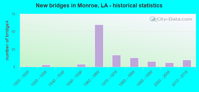
- New bridges - historical statistics
- 11920-1929
- 31930-1939
- 41950-1959
- 601960-1969
- 171970-1979
- 131980-1989
- 81990-1999
- 62000-2009
- 102010-2019


- Bridge Condition - Deck
- 2.9%Very good
- 20.6%Good
- 63.7%Satisfactory
- 6.9%Fair
- 3.9%Poor
- 2.0%Serious
- 1.0%Failed

- Bridge Condition - Superstructure
- 2.9%Very good
- 29.4%Good
- 58.8%Satisfactory
- 6.9%Fair
- 2.0%Poor
- 1.0%Failed

- Bridge Condition - Substructure
- 5.9%Very good
- 30.4%Good
- 51.0%Satisfactory
- 4.9%Fair
- 4.9%Poor
- 2.0%Imminent failure
- 1.0%Failed

- Bridge Condition - Channel
- 10.0%Very good
- 8.9%Good
- 70.0%Satisfactory
- 1.1%Fair
- 8.9%Poor
- 1.1%Failed

- Bridge Condition - Culverts
- 10.0%Very good
- 35.0%Good
- 55.0%Satisfactory
Find on map >> Show street view
Structure Number: 53700000050225, Location: 1.0 MI. WEST OF MILLHAVEN (Lat: 32.489239, Lng: -91.998961), Route carried "on" structure: County highway , Year Built: 2012, Status: Open, Structure Length: 3.05m (10.01ft), Average Daily Traffic: 350 (year 2011), Average Future Daily Traffic: 210 (year 2036), Design Load: HS 20, Features Intersected: BENNENT BAYOU, Facility Carried by Structure: FRONTAGE RD
Minimum Vertical Clearance: 30+ m (98+ ft), Kilometerpoint: 0.000, Lanes on structure: 2, Owner: County Highway Agency, Approaching Roadway Width: 7.6m (24.9ft), Skew: 30 degrees, Material/Design: Concrete, Design/Construction: Slab, Number Of Spans In Main Unit: 5, Length of Maximum Span: 6.1m (20.0ft), Curb-To-Curb Width: 10.4m (34.1ft), Out-to-Out Width: 11.1m (36.4ft)
Condition: Deck: Satisfactory, Superstructure: Satisfactory, Substructure: Satisfactory, Channel: Satisfactory, Operating Rating: 42.4 metric tons, Method Used To Determine Operating Rating: Load and Resistance Factor Rating (LRFR) rating reported by rating factor(RF) method using HL-93 loadings, Inventory Rating: 32.7 metric tons, Method Used To Determine Inventory Rating: Load and Resistance Factor Rating (LRFR) rating reported by rating factor(RF) method using HL-93 loadings, Structural Evaluation: Equal to present minimum criteria, Deck Geometry: Better than present minimum criteria, Waterway Adequacy: Equal to present desirable criteria, Approach Roadway Alignment: Equal to present desirable criteria, Designated Inspection Frequency: Every 24 months, Inspection Date: March 2020, Deck Structure Type: Concrete Cast-file-Place, Wearing Surface/Protective System: Wearing Surface: Monolithic Concrete
Find on map >> Show street view
Structure Number: 53700000050239, Location: 0.69 MILES NORTH OF LA 15 (Lat: 32.492361, Lng: -92.082900), Route carried "on" structure: ServiceUS 165, Year Built: 2013, Status: Open, Structure Length: 3.66m (12.01ft), Average Daily Traffic: 2,750 (year 2016), Truck Traffic: 8%, Average Future Daily Traffic: 1,548 (year 2036), Design Load: HL 93, Features Intersected: YOUNGS BAYOU
Minimum Vertical Clearance: 30+ m (98+ ft), Kilometerpoint: 1.292, Lanes on structure: 2, Owner: State Highway Agency, Approaching Roadway Width: 10.4m (34.1ft), Skew: 30 degrees, Material/Design: Concrete, Design/Construction: Slab, Number Of Spans In Main Unit: 6, Length of Maximum Span: 6.1m (20.0ft), Curb-To-Curb Width: 11.8m (38.7ft), Out-to-Out Width: 13.0m (42.7ft)
Condition: Deck: Good, Superstructure: Good, Substructure: Very good, Channel: Satisfactory, Operating Rating: 51.5 metric tons, Method Used To Determine Operating Rating: Load and Resistance Factor Rating (LRFR) rating reported by rating factor(RF) method using HL-93 loadings, Inventory Rating: 39.5 metric tons, Method Used To Determine Inventory Rating: Load and Resistance Factor Rating (LRFR) rating reported by rating factor(RF) method using HL-93 loadings, Structural Evaluation: Better than present minimum criteria, Deck Geometry: Somewhat better than minimum adequacy, Waterway Adequacy: Equal to present desirable criteria, Approach Roadway Alignment: Equal to present minimum criteria, Designated Inspection Frequency: Every 24 months, Inspection Date: August 2020, Deck Structure Type: Concrete Cast-file-Place, Wearing Surface/Protective System: Wearing Surface: Monolithic Concrete
Find on map >> Show street view
Structure Number: 53700000050241, Location: 0.69 MILES NORTH OF LA 15 (Lat: 32.492661, Lng: -92.083800), Route carried "on" structure: ServiceUS 165, Year Built: 2013, Status: Open, Structure Length: 3.66m (12.01ft), Average Daily Traffic: 2,750 (year 2016), Truck Traffic: 8%, Average Future Daily Traffic: 1,548 (year 2036), Design Load: HL 93, Features Intersected: YOUNGS BAYOU
Minimum Vertical Clearance: 30+ m (98+ ft), Kilometerpoint: 0.124, Lanes on structure: 2, Owner: State Highway Agency, Approaching Roadway Width: 10.4m (34.1ft), Skew: 30 degrees, Material/Design: Concrete, Design/Construction: Slab, Number Of Spans In Main Unit: 6, Length of Maximum Span: 6.1m (20.0ft), Curb-To-Curb Width: 11.8m (38.7ft), Out-to-Out Width: 13.0m (42.7ft)
Condition: Deck: Good, Superstructure: Good, Substructure: Very good, Channel: Very good, Operating Rating: 51.5 metric tons, Method Used To Determine Operating Rating: Load and Resistance Factor Rating (LRFR) rating reported by rating factor(RF) method using HL-93 loadings, Inventory Rating: 39.5 metric tons, Method Used To Determine Inventory Rating: Load and Resistance Factor Rating (LRFR) rating reported by rating factor(RF) method using HL-93 loadings, Structural Evaluation: Better than present minimum criteria, Deck Geometry: Somewhat better than minimum adequacy, Waterway Adequacy: Equal to present minimum criteria, Approach Roadway Alignment: Equal to present desirable criteria, Designated Inspection Frequency: Every 24 months, Inspection Date: August 2020, Deck Structure Type: Concrete Cast-file-Place, Wearing Surface/Protective System: Wearing Surface: Monolithic Concrete
Find on map >> Show street view
Structure Number: 53700000050271, Location: 0.9 MI E OF US 165 (Lat: 32.511869, Lng: -92.066789), Route carried "on" structure: County highway , Year Built: 2016, Status: Open, Structure Length: 1.22m (4.00ft), Average Daily Traffic: 850 (year 1980), Average Future Daily Traffic: 510 (year 2036), Design Load: HS 20, Features Intersected: AIRPORT CANAL, Facility Carried by Structure: ELM ST
Minimum Vertical Clearance: 30+ m (98+ ft), Kilometerpoint: 0.000, Lanes on structure: 2, Owner: City or Municipal Highway Agency, Approaching Roadway Width: 8.5m (27.9ft), Skew: 30 degrees, Material/Design: Concrete, Design/Construction: Slab, Number Of Spans In Main Unit: 2, Length of Maximum Span: 6.1m (20.0ft), Curb-To-Curb Width: 9.5m (31.2ft), Out-to-Out Width: 10.5m (34.4ft)
Condition: Deck: Very good, Superstructure: Very good, Substructure: Very good, Channel: Good, Operating Rating: 59.9 metric tons, Method Used To Determine Operating Rating: Load and Resistance Factor Rating (LRFR) rating reported by rating factor(RF) method using HL-93 loadings, Inventory Rating: 46.0 metric tons, Method Used To Determine Inventory Rating: Load and Resistance Factor Rating (LRFR) rating reported by rating factor(RF) method using HL-93 loadings, Structural Evaluation: Equal to present desirable criteria, Deck Geometry: Equal to present minimum criteria, Waterway Adequacy: Equal to present minimum criteria, Approach Roadway Alignment: Equal to present minimum criteria, Designated Inspection Frequency: Every 24 months, Inspection Date: July 2020, Deck Structure Type: Concrete Cast-file-Place, Wearing Surface/Protective System: Wearing Surface: Monolithic Concrete
Find on map >> Show street view
Structure Number: 53700000050288, Location: 2.4 MI NW OF US 165 (Lat: 32.558869, Lng: -92.097569), Route carried "on" structure: City street , Year Built: 2017, Status: Open, Structure Length: 0.98m (3.22ft), Average Daily Traffic: 1,686 (year 2017), Truck Traffic: 2%, Average Future Daily Traffic: 1,825 (year 2037), Features Intersected: HOGS BAYOU, Facility Carried by Structure: DEBORAH DR.
Minimum Vertical Clearance: 30+ m (98+ ft), Kilometerpoint: 0.000, Lanes on structure: 2, Owner: City or Municipal Highway Agency, Approaching Roadway Width: 10.4m (34.1ft), Skew: 4 degrees, Material/Design: Concrete, Design/Construction: Culvert, Number Of Spans In Main Unit: 2, Length of Maximum Span: 4.3m (14.1ft), Out-to-Out Width: 26.8m (87.9ft)
Condition: Channel: Very good, Culverts: Very good, Operating Rating: 42.1 metric tons, Method Used To Determine Operating Rating: Load and Resistance Factor Rating (LRFR) rating reported by rating factor(RF) method using HL-93 loadings, Inventory Rating: 32.4 metric tons, Method Used To Determine Inventory Rating: Load and Resistance Factor Rating (LRFR) rating reported by rating factor(RF) method using HL-93 loadings, Structural Evaluation: Equal to present desirable criteria, Waterway Adequacy: Equal to present minimum criteria, Approach Roadway Alignment: Equal to present minimum criteria, Designated Inspection Frequency: Every 24 months, Inspection Date: July 2020
Find on map >> Show street view
Structure Number: 53700000050289, Location: 1.6 MI W OF US 165 (Lat: 32.511361, Lng: -92.096511), Route carried "on" structure: City street , Year Built: 2017, Status: Open, Structure Length: 0.85m (2.79ft), Average Daily Traffic: 188 (year 2017), Average Future Daily Traffic: 250 (year 2037), Features Intersected: CROCODILE CR, Facility Carried by Structure: WOOD ST
Minimum Vertical Clearance: 30+ m (98+ ft), Kilometerpoint: 0.000, Lanes on structure: 2, Owner: City or Municipal Highway Agency, Approaching Roadway Width: 5.2m (17.1ft), Skew: 2 degrees, Material/Design: Concrete, Design/Construction: Culvert, Number Of Spans In Main Unit: 2, Length of Maximum Span: 3.7m (12.1ft), Out-to-Out Width: 16.5m (54.1ft)
Condition: Channel: Good, Culverts: Good, Operating Rating: 43.4 metric tons, Method Used To Determine Operating Rating: Load and Resistance Factor Rating (LRFR) rating reported by rating factor(RF) method using HL-93 loadings, Inventory Rating: 33.7 metric tons, Method Used To Determine Inventory Rating: Load and Resistance Factor Rating (LRFR) rating reported by rating factor(RF) method using HL-93 loadings, Structural Evaluation: Better than present minimum criteria, Waterway Adequacy: Equal to present desirable criteria, Approach Roadway Alignment: Equal to present desirable criteria, Designated Inspection Frequency: Every 24 months, Inspection Date: August 2020
Find on map >> Show street view
Structure Number: 5370000005029, Location: 1.6 MI W OF US 165 (Lat: 32.515469, Lng: -92.097689), Route carried "on" structure: City street , Year Built: 2017, Status: Open, Structure Length: 0.67m (2.20ft), Average Daily Traffic: 36 (year 2017), Average Future Daily Traffic: 100 (year 2037), Features Intersected: E PRONG YOUNGS BAYOU, Facility Carried by Structure: ADAMS ST
Minimum Vertical Clearance: 30+ m (98+ ft), Kilometerpoint: 0.000, Lanes on structure: 2, Owner: City or Municipal Highway Agency, Approaching Roadway Width: 4.9m (16.1ft), Material/Design: Concrete, Design/Construction: Culvert, Number Of Spans In Main Unit: 2, Length of Maximum Span: 3.0m (9.8ft), Out-to-Out Width: 14.6m (47.9ft)
Condition: Channel: Satisfactory, Culverts: Good, Operating Rating: 47.0 metric tons, Method Used To Determine Operating Rating: Load and Resistance Factor Rating (LRFR) rating reported by rating factor(RF) method using HL-93 loadings, Inventory Rating: 36.3 metric tons, Method Used To Determine Inventory Rating: Load and Resistance Factor Rating (LRFR) rating reported by rating factor(RF) method using HL-93 loadings, Structural Evaluation: Better than present minimum criteria, Waterway Adequacy: Equal to present desirable criteria, Approach Roadway Alignment: Equal to present desirable criteria, Designated Inspection Frequency: Every 24 months, Inspection Date: August 2020
Find on map >> Show street view
Structure Number: 53700000400527, Location: 0.1 MI. SOUTH OF LA 594 (Lat: 32.502039, Lng: -92.089300), Route carried "on" structure: County highway , Year Built: 2013, Status: Open, Structure Length: 1.83m (6.00ft), Average Daily Traffic: 5,600 (year 2010), Average Future Daily Traffic: 3,360 (year 2036), Design Load: HS 20, Features Intersected: YOUNGS BAYOU, Facility Carried by Structure: ORANGE ST
Minimum Vertical Clearance: 30+ m (98+ ft), Kilometerpoint: 0.000, Lanes on structure: 2, Owner: City or Municipal Highway Agency, Approaching Roadway Width: 6.4m (21.0ft), Skew: 36 degrees, Material/Design: Concrete, Design/Construction: Slab, Number Of Spans In Main Unit: 3, Length of Maximum Span: 6.1m (20.0ft), Curb-To-Curb Width: 8.2m (26.9ft), Out-to-Out Width: 9.3m (30.5ft)
Condition: Deck: Very good, Superstructure: Very good, Substructure: Good, Channel: Very good, Operating Rating: 48.6 metric tons, Method Used To Determine Operating Rating: Load and Resistance Factor Rating (LRFR) rating reported by rating factor(RF) method using HL-93 loadings, Inventory Rating: 37.6 metric tons, Method Used To Determine Inventory Rating: Load and Resistance Factor Rating (LRFR) rating reported by rating factor(RF) method using HL-93 loadings, Structural Evaluation: Better than present minimum criteria, Deck Geometry: High priority of replacement, Waterway Adequacy: Equal to present desirable criteria, Approach Roadway Alignment: Equal to present desirable criteria, Designated Inspection Frequency: Every 24 months, Inspection Date: July 2020, Deck Structure Type: Concrete Cast-file-Place, Wearing Surface/Protective System: Wearing Surface: Monolithic Concrete
Find on map >> Show street view
Structure Number: 53700000400712, Location: UNDER SICARD OVERPASS (Lat: 32.529511, Lng: -92.030539), Route carried "on" structure: County highway , Year Built: 2011, Status: Open, Structure Length: 1.13m (3.71ft), Average Daily Traffic: 400 (year 2010), Average Future Daily Traffic: 240 (year 2036), Design Load: HS 20, Features Intersected: BENNET BAYOU, Facility Carried by Structure: RIFLE RANGE RD
Minimum Vertical Clearance: 30+ m (98+ ft), Kilometerpoint: 0.000, Lanes on structure: 2, Owner: City or Municipal Highway Agency, Approaching Roadway Width: 5.8m (19.0ft), Skew: 36 degrees, Material/Design: Concrete, Design/Construction: Culvert, Number Of Spans In Main Unit: 3, Length of Maximum Span: 3.0m (9.8ft)
Condition: Channel: Satisfactory, Culverts: Good, Operating Rating: 32.4 metric tons, Method Used To Determine Operating Rating: Load and Resistance Factor Rating (LRFR) rating reported by rating factor(RF) method using HL-93 loadings, Inventory Rating: 24.9 metric tons, Method Used To Determine Inventory Rating: Load and Resistance Factor Rating (LRFR) rating reported by rating factor(RF) method using HL-93 loadings, Structural Evaluation: Equal to present minimum criteria, Waterway Adequacy: Equal to present desirable criteria, Approach Roadway Alignment: Equal to present minimum criteria, Designated Inspection Frequency: Every 24 months, Inspection Date: August 2020, Deck Structure Type: Concrete Cast-file-Place
Find on map >> Show street view
Structure Number: 53700000400851, Location: 1.21 MI. EAST OF US 165 (Lat: 32.485519, Lng: -92.073639), Route carried "on" structure: County highway , Year Built: 2013, Status: Open, Structure Length: 4.27m (14.01ft), Average Daily Traffic: 4,000 (year 2010), Average Future Daily Traffic: 2,400 (year 2036), Design Load: HS 20, Features Intersected: YOUNG'S BAYOU, Facility Carried by Structure: HADLEY ST
Minimum Vertical Clearance: 30+ m (98+ ft), Kilometerpoint: 0.000, Lanes on structure: 2, Owner: County Highway Agency, Approaching Roadway Width: 9.8m (32.2ft), Skew: 36 degrees, Material/Design: Concrete, Design/Construction: Slab, Number Of Spans In Main Unit: 7, Length of Maximum Span: 6.1m (20.0ft), Curb-To-Curb Width: 8.4m (27.6ft), Out-to-Out Width: 9.3m (30.5ft)
Condition: Deck: Good, Superstructure: Good, Substructure: Good, Channel: Very good, Operating Rating: 48.3 metric tons, Method Used To Determine Operating Rating: Load and Resistance Factor Rating (LRFR) rating reported by rating factor(RF) method using HL-93 loadings, Inventory Rating: 37.3 metric tons, Method Used To Determine Inventory Rating: Load and Resistance Factor Rating (LRFR) rating reported by rating factor(RF) method using HL-93 loadings, Structural Evaluation: Better than present minimum criteria, Deck Geometry: High priority of corrective action, Waterway Adequacy: Equal to present minimum criteria, Approach Roadway Alignment: Equal to present minimum criteria, Designated Inspection Frequency: Every 24 months, Inspection Date: April 2020, Deck Structure Type: Concrete Cast-file-Place, Wearing Surface/Protective System: Wearing Surface: Monolithic Concrete
Find on map >> Show street view
Structure Number: 53700010918151, Location: 1.6 MI WEST OF LA 840-6 (Lat: 32.504869, Lng: -92.126600), Route carried "on" structure: US 80, Year Built: 1936, Status: Open, Structure Length: 35.66m (116.99ft), Average Daily Traffic: 30,200 (year 2016), Truck Traffic: 9%, Average Future Daily Traffic: 17,580 (year 2036), Design Load: H 15, Features Intersected: OUACHITA RIVER-LOUISVILL
Minimum Vertical Clearance: 30+ m (98+ ft), Kilometerpoint: 29.012, Lanes on structure: 4, Base Highway Network: Yes (Inventory Route: 1-09-1, Subroute: 10), Owner: State Highway Agency, Approaching Roadway Width: 12.5m (41.0ft), Navigation Control: Yes ( Vertical Clearance: 11.6m (38.1ft), Horizontal Clearance: 39.9m (130.9ft)), Material/Design: Steel, Design/Construction: Movable - Bascule, Number Of Spans In Main Unit: 1, Number Of Approach Spans: 15, Length of Maximum Span: 48.8m (160.1ft), Curb or Sidewalk Widths: Left: 1.8m (5.9ft), Right: 1.8m (5.9ft), Curb-To-Curb Width: 12.2m (40.0ft), Out-to-Out Width: 16.5m (54.1ft)
Condition: Deck: Satisfactory, Superstructure: Satisfactory, Substructure: Satisfactory, Channel: Satisfactory, Operating Rating: 24.3 metric tons, Method Used To Determine Operating Rating: Load and Resistance Factor Rating (LRFR) rating reported by rating factor(RF) method using HL-93 loadings, Inventory Rating: 18.8 metric tons, Method Used To Determine Inventory Rating: Load and Resistance Factor Rating (LRFR) rating reported by rating factor(RF) method using HL-93 loadings, Structural Evaluation: Meets minimum limits, Deck Geometry: High priority of replacement, Waterway Adequacy: Better than present minimum criteria, Approach Roadway Alignment: Equal to present desirable criteria, Length Of Structure Improvement: 35.66m (116.99ft), Designated Inspection Frequency: Every 24 months, Critical Feature Inspection Frequency: Every 24 months, Underwater Inspection Frequency: Every 60 months, Inspection Date: May 2020, Critical Feature Inspection Date: May 2020, Underwater Inspection Date: June 2018, Bridge Improvement Cost: $3,042,000, Total Project Cost: $4,563,000 ( Estimate for 2016), Deck Structure Type: Open Grating, Wearing Surface/Protective System: Wearing Surface: Monolithic Concrete
Find on map >> Show street view
Structure Number: 53700010919261, Location: .5 MI WEST OF LA 840-6 (Lat: 32.513931, Lng: -92.112300), Route carried "on" structure: US 80, Year Built: 1935, Status: Open, Structure Length: 0.98m (3.22ft), Average Daily Traffic: 20,600 (year 2016), Truck Traffic: 9%, Average Future Daily Traffic: 11,400 (year 2036), Design Load: HS 20, Features Intersected: YOUNGS BAYOU
Minimum Vertical Clearance: 30+ m (98+ ft), Kilometerpoint: 30.685, Lanes on structure: 5, Base Highway Network: Yes (Inventory Route: 1-09-1, Subroute: 10), Owner: State Highway Agency, Approaching Roadway Width: 19.5m (64.0ft), Skew: 4 degrees, Material/Design: Concrete, Design/Construction: Culvert, Number Of Spans In Main Unit: 3, Length of Maximum Span: 3.0m (9.8ft), Curb-To-Curb Width: 19.5m (64.0ft), Out-to-Out Width: 19.8m (65.0ft)
Condition: Channel: Satisfactory, Culverts: Satisfactory, Operating Rating: 32.4 metric tons, Method Used To Determine Operating Rating: Assigned ratings based on Load and Resistance Factor Design (LRFD) reported by rating factor (RF) using HL93 loadings, Inventory Rating: 24.9 metric tons, Method Used To Determine Inventory Rating: Assigned ratings based on Load and Resistance Factor Design (LRFD) reported by rating factor (RF) using HL93 loadings, Structural Evaluation: Equal to present minimum criteria, Deck Geometry: Meets minimum limits, Waterway Adequacy: Equal to present minimum criteria, Approach Roadway Alignment: Equal to present minimum criteria, Designated Inspection Frequency: Every 24 months, Inspection Date: August 2020, Deck Structure Type: Concrete Cast-file-Place
Find on map >> Show street view
Structure Number: 53700010920351, Location: .7 MI EAST OF LA 840-6 (Lat: 32.523839, Lng: -92.096800), Route carried "on" structure: US 80, Year Built: 1962, Status: Open, Structure Length: 1.52m (4.99ft), Average Daily Traffic: 22,100 (year 2016), Truck Traffic: 9%, Average Future Daily Traffic: 13,620 (year 2036), Design Load: HS 20, Features Intersected: YOUNGS BAYOU
Minimum Vertical Clearance: 30+ m (98+ ft), Kilometerpoint: 32.507, Lanes on structure: 5, Base Highway Network: Yes (Inventory Route: 1-09-1, Subroute: 10), Owner: State Highway Agency, Approaching Roadway Width: 19.5m (64.0ft), Skew: 20 degrees, Material/Design: Concrete, Design/Construction: Slab, Number Of Spans In Main Unit: 2, Length of Maximum Span: 7.6m (24.9ft), Curb or Sidewalk Widths: Left: 0.9m (3.0ft), Right: 0.9m (3.0ft), Curb-To-Curb Width: 21.3m (69.9ft), Out-to-Out Width: 23.9m (78.4ft)
Condition: Deck: Good, Superstructure: Good, Substructure: Good, Channel: Satisfactory, Operating Rating: 78.9 metric tons, Method Used To Determine Operating Rating: Load Factor (LF), Inventory Rating: 48.1 metric tons, Method Used To Determine Inventory Rating: Load Factor (LF), Structural Evaluation: Better than present minimum criteria, Deck Geometry: Somewhat better than minimum adequacy, Waterway Adequacy: Better than present minimum criteria, Approach Roadway Alignment: Better than present minimum criteria, Designated Inspection Frequency: Every 24 months, Inspection Date: August 2020, Deck Structure Type: Concrete Cast-file-Place, Wearing Surface/Protective System: Wearing Surface: Bituminous
Find on map >> Show street view
Structure Number: 53700150816631, Location: .3 MI NORTH OF I-20 (Lat: 32.502869, Lng: -92.110000), Route carried "on" structure: Business US 165, Year Built: 1971, Status: Open, Structure Length: 54.50m (178.81ft), Average Daily Traffic: 4,400 (year 2016), Truck Traffic: 9%, Average Future Daily Traffic: 2,664 (year 2036), Design Load: HS 20, Features Intersected: DESIARD ST & ICG RR
Minimum Vertical Clearance: 30+ m (98+ ft), Kilometerpoint: 26.649, Lanes on structure: 2, Lanes under structure: 4, Base Highway Network: Yes (Inventory Route: 15-08-1, Subroute: 10), Owner: State Highway Agency, Approaching Roadway Width: 12.2m (40.0ft), Skew: 19 degrees, Material/Design: Steel, Design/Construction: Stringer/Multi-beam, Number Of Spans In Main Unit: 24, Length of Maximum Span: 42.4m (139.1ft), Curb-To-Curb Width: 9.1m (29.9ft), Out-to-Out Width: 10.3m (33.8ft)
Condition: Deck: Satisfactory, Superstructure: Good, Substructure: Good, Operating Rating: 61.7 metric tons, Method Used To Determine Operating Rating: Load Factor (LF), Inventory Rating: 37.2 metric tons, Method Used To Determine Inventory Rating: Load Factor (LF), Structural Evaluation: Better than present minimum criteria, Deck Geometry: Meets minimum limits, Underclear: Superior to present desirable criteria, Approach Roadway Alignment: Better than present minimum criteria, Designated Inspection Frequency: Every 24 months, Inspection Date: September 2020, Deck Structure Type: Concrete Cast-file-Place, Wearing Surface/Protective System: Wearing Surface: Wood or Timber
Find on map >> Show street view
Structure Number: 53700150816632, Location: .3 MI NORTH OF I-20 (Lat: 32.506489, Lng: -92.115000), Route carried "on" structure: Business US 165, Year Built: 1971, Status: Open, Structure Length: 54.50m (178.81ft), Average Daily Traffic: 4,400 (year 2016), Truck Traffic: 9%, Average Future Daily Traffic: 2,664 (year 2036), Design Load: HS 20, Features Intersected: CITY ST & ICRR
Minimum Vertical Clearance: 30+ m (98+ ft), Kilometerpoint: 0.520, Lanes on structure: 2, Lanes under structure: 4, Base Highway Network: Yes (Inventory Route: 15-08-2, Subroute: 10), Owner: State Highway Agency, Approaching Roadway Width: 12.2m (40.0ft), Skew: 19 degrees, Material/Design: Steel, Design/Construction: Stringer/Multi-beam, Number Of Spans In Main Unit: 24, Length of Maximum Span: 42.4m (139.1ft), Curb-To-Curb Width: 9.1m (29.9ft), Out-to-Out Width: 10.3m (33.8ft)
Condition: Deck: Satisfactory, Superstructure: Good, Substructure: Good, Operating Rating: 69.8 metric tons, Method Used To Determine Operating Rating: Load Factor (LF), Inventory Rating: 41.7 metric tons, Method Used To Determine Inventory Rating: Load Factor (LF), Structural Evaluation: Better than present minimum criteria, Deck Geometry: Meets minimum limits, Underclear: Superior to present desirable criteria, Approach Roadway Alignment: Better than present minimum criteria, Designated Inspection Frequency: Every 24 months, Inspection Date: September 2020, Deck Structure Type: Concrete Cast-file-Place, Wearing Surface/Protective System: Wearing Surface: Monolithic Concrete
Find on map >> Show street view
Structure Number: 53700153103651, Location: 3.65 MI NORTH OF US 165 B (Lat: 32.460989, Lng: -92.082100), Route carried "on" structure: US 165, Year Built: 1963, Year Reconstructed: 1981, Status: Open, Structure Length: 2.44m (8.01ft), Average Daily Traffic: 11,800 (year 2016), Truck Traffic: 9%, Average Future Daily Traffic: 8,352 (year 2036), Design Load: HS 20, Features Intersected: PINE BAYOU
Minimum Vertical Clearance: 30+ m (98+ ft), Kilometerpoint: 5.951, Lanes on structure: 2, Base Highway Network: Yes (Inventory Route: 15-31-1, Subroute: 10), Owner: State Highway Agency, Approaching Roadway Width: 13.4m (44.0ft), Skew: 10 degrees, Material/Design: Concrete, Design/Construction: Slab, Number Of Spans In Main Unit: 4, Length of Maximum Span: 6.1m (20.0ft), Curb-To-Curb Width: 12.2m (40.0ft), Out-to-Out Width: 13.0m (42.7ft)
Condition: Deck: Satisfactory, Superstructure: Satisfactory, Substructure: Satisfactory, Channel: Satisfactory, Operating Rating: 62.6 metric tons, Method Used To Determine Operating Rating: Load Factor (LF), Inventory Rating: 37.2 metric tons, Method Used To Determine Inventory Rating: Load Factor (LF), Structural Evaluation: Equal to present minimum criteria, Deck Geometry: Better than present minimum criteria, Waterway Adequacy: Better than present minimum criteria, Approach Roadway Alignment: Better than present minimum criteria, Designated Inspection Frequency: Every 24 months, Inspection Date: July 2020, Deck Structure Type: Concrete Cast-file-Place, Wearing Surface/Protective System: Wearing Surface: Monolithic Concrete
Find on map >> Show street view
Structure Number: 53700153103652, Location: 3.65 MI NORTH OF US 165 B (Lat: 32.461211, Lng: -92.082400), Route carried "on" structure: US 165, Year Built: 1963, Year Reconstructed: 1981, Status: Open, Structure Length: 2.44m (8.01ft), Average Daily Traffic: 11,800 (year 2016), Truck Traffic: 9%, Average Future Daily Traffic: 8,352 (year 2036), Design Load: HS 20, Features Intersected: PINE BAYOU
Minimum Vertical Clearance: 30+ m (98+ ft), Kilometerpoint: 6.799, Lanes on structure: 2, Base Highway Network: Yes (Inventory Route: 15-31-2, Subroute: 10), Owner: State Highway Agency, Approaching Roadway Width: 13.4m (44.0ft), Skew: 10 degrees, Material/Design: Concrete, Design/Construction: Slab, Number Of Spans In Main Unit: 4, Length of Maximum Span: 6.1m (20.0ft), Curb-To-Curb Width: 12.2m (40.0ft), Out-to-Out Width: 13.0m (42.7ft)
Condition: Deck: Satisfactory, Superstructure: Satisfactory, Substructure: Satisfactory, Channel: Satisfactory, Operating Rating: 62.6 metric tons, Method Used To Determine Operating Rating: Load Factor (LF), Inventory Rating: 37.2 metric tons, Method Used To Determine Inventory Rating: Load Factor (LF), Structural Evaluation: Equal to present minimum criteria, Deck Geometry: Better than present minimum criteria, Waterway Adequacy: Equal to present desirable criteria, Approach Roadway Alignment: Equal to present desirable criteria, Designated Inspection Frequency: Every 24 months, Inspection Date: July 2020, Deck Structure Type: Concrete Cast-file-Place, Wearing Surface/Protective System: Wearing Surface: Monolithic Concrete
Find on map >> Show street view
Structure Number: 53700153105821, Location: .7 MI NORTH OF LA 15 (Lat: 32.492311, Lng: -92.083200), Route carried "on" structure: US 165, Year Built: 1966, Status: Open, Structure Length: 3.66m (12.01ft), Average Daily Traffic: 13,850 (year 2018), Truck Traffic: 9%, Average Future Daily Traffic: 9,288 (year 2036), Design Load: HS 20, Features Intersected: YOUNGS BAYOU
Minimum Vertical Clearance: 30+ m (98+ ft), Kilometerpoint: 9.426, Lanes on structure: 2, Base Highway Network: Yes (Inventory Route: 15-31-1, Subroute: 10), Owner: State Highway Agency, Approaching Roadway Width: 11.6m (38.1ft), Skew: 10 degrees, Material/Design: Concrete, Design/Construction: Slab, Number Of Spans In Main Unit: 6, Length of Maximum Span: 6.1m (20.0ft), Curb-To-Curb Width: 8.5m (27.9ft), Out-to-Out Width: 10.2m (33.5ft)
Condition: Deck: Satisfactory, Superstructure: Satisfactory, Substructure: Poor, Channel: Satisfactory, Operating Rating: 33.4 metric tons, Method Used To Determine Operating Rating: Load and Resistance Factor Rating (LRFR) rating reported by rating factor(RF) method using HL-93 loadings, Inventory Rating: 25.6 metric tons, Method Used To Determine Inventory Rating: Load and Resistance Factor Rating (LRFR) rating reported by rating factor(RF) method using HL-93 loadings, Structural Evaluation: Meets minimum limits, Deck Geometry: High priority of corrective action, Waterway Adequacy: Equal to present desirable criteria, Approach Roadway Alignment: Equal to present desirable criteria, Length Of Structure Improvement: 4.57m (14.99ft), Designated Inspection Frequency: Every 12 months, Inspection Date: August 2021, Bridge Improvement Cost: $390,000, Total Project Cost: $585,000 ( Estimate for 2016), Deck Structure Type: Concrete Cast-file-Place, Wearing Surface/Protective System: Wearing Surface: Monolithic Concrete
Find on map >> Show street view
Structure Number: 53700153105822, Location: .7 MI NORTH OF LA 15 (Lat: 32.492669, Lng: -92.083400), Route carried "on" structure: US 165, Year Built: 1966, Status: Open, Structure Length: 3.66m (12.01ft), Average Daily Traffic: 13,750 (year 2016), Truck Traffic: 9%, Average Future Daily Traffic: 9,288 (year 2036), Design Load: HS 20, Features Intersected: YOUNGS BAYOU
Minimum Vertical Clearance: 30+ m (98+ ft), Kilometerpoint: 3.310, Lanes on structure: 2, Base Highway Network: Yes (Inventory Route: 15-31-2, Subroute: 10), Owner: State Highway Agency, Approaching Roadway Width: 11.6m (38.1ft), Skew: 10 degrees, Material/Design: Concrete, Design/Construction: Slab, Number Of Spans In Main Unit: 6, Length of Maximum Span: 6.1m (20.0ft), Curb-To-Curb Width: 8.5m (27.9ft), Out-to-Out Width: 10.2m (33.5ft)
Condition: Deck: Satisfactory, Superstructure: Satisfactory, Substructure: Fair, Channel: Satisfactory, Operating Rating: 54.4 metric tons, Method Used To Determine Operating Rating: Load Factor (LF), Inventory Rating: 32.7 metric tons, Method Used To Determine Inventory Rating: Load Factor (LF), Structural Evaluation: Somewhat better than minimum adequacy, Deck Geometry: High priority of corrective action, Waterway Adequacy: Equal to present minimum criteria, Approach Roadway Alignment: Better than present minimum criteria, Length Of Structure Improvement: 4.57m (14.99ft), Designated Inspection Frequency: Every 24 months, Inspection Date: August 2020, Bridge Improvement Cost: $390,000, Total Project Cost: $585,000 ( Estimate for 2016), Deck Structure Type: Concrete Cast-file-Place, Wearing Surface/Protective System: Wearing Surface: Monolithic Concrete
Find on map >> Show street view
Structure Number: 53700153106361, Location: US 165 OVER I-20 (Lat: 32.500811, Lng: -92.082600), Route carried "on" structure: US 165, Year Built: 1966, Status: Open, Structure Length: 23.47m (77.00ft), Average Daily Traffic: 23,850 (year 2016), Truck Traffic: 9%, Average Future Daily Traffic: 16,488 (year 2036), Design Load: HS 20, Features Intersected: LA 594&ICRR
Minimum Vertical Clearance: 30+ m (98+ ft), Kilometerpoint: 10.377, Lanes on structure: 2, Lanes under structure: 2, Base Highway Network: Yes (Inventory Route: 15-31-1, Subroute: 10), Owner: State Highway Agency, Approaching Roadway Width: 14.6m (47.9ft), Skew: 10 degrees, Material/Design: Steel, Design/Construction: Stringer/Multi-beam, Number Of Spans In Main Unit: 18, Length of Maximum Span: 19.8m (65.0ft), Curb-To-Curb Width: 8.5m (27.9ft), Out-to-Out Width: 10.2m (33.5ft)
Condition: Deck: Satisfactory, Superstructure: Satisfactory, Substructure: Satisfactory, Operating Rating: 31.4 metric tons, Method Used To Determine Operating Rating: Load and Resistance Factor Rating (LRFR) rating reported by rating factor(RF) method using HL-93 loadings, Inventory Rating: 24.3 metric tons, Method Used To Determine Inventory Rating: Load and Resistance Factor Rating (LRFR) rating reported by rating factor(RF) method using HL-93 loadings, Structural Evaluation: Equal to present minimum criteria, Deck Geometry: High priority of corrective action, Underclear: Equal to present desirable criteria, Approach Roadway Alignment: Better than present minimum criteria, Length Of Structure Improvement: 23.96m (78.61ft), Designated Inspection Frequency: Every 24 months, Inspection Date: September 2020, Bridge Improvement Cost: $2,043,000, Total Project Cost: $3,064,000 ( Estimate for 2016), Deck Structure Type: Concrete Cast-file-Place, Wearing Surface/Protective System: Wearing Surface: Monolithic Concrete
Find on map >> Show street view
Structure Number: 53700153106362, Location: US 165 OVER I-20 (Lat: 32.502950, Lng: -92.082700), Route carried "on" structure: US 165, Year Built: 1966, Status: Open, Structure Length: 21.95m (72.01ft), Average Daily Traffic: 47,700 (year 2016), Truck Traffic: 9%, Average Future Daily Traffic: 16,488 (year 2036), Design Load: HS 20, Features Intersected: LA 549 & ICRR
Minimum Vertical Clearance: 30+ m (98+ ft), Kilometerpoint: 2.168, Lanes on structure: 2, Lanes under structure: 2, Base Highway Network: Yes (Inventory Route: 15-31-2, Subroute: 10), Owner: State Highway Agency, Approaching Roadway Width: 15.2m (49.9ft), Skew: 10 degrees, Material/Design: Steel, Design/Construction: Stringer/Multi-beam, Number Of Spans In Main Unit: 17, Length of Maximum Span: 18.3m (60.0ft), Curb-To-Curb Width: 8.5m (27.9ft), Out-to-Out Width: 10.2m (33.5ft)
Condition: Deck: Satisfactory, Superstructure: Satisfactory, Substructure: Satisfactory, Operating Rating: 69.8 metric tons, Method Used To Determine Operating Rating: Load Factor (LF), Inventory Rating: 41.7 metric tons, Method Used To Determine Inventory Rating: Load Factor (LF), Structural Evaluation: Equal to present minimum criteria, Deck Geometry: Meets minimum limits, Underclear: Better than present minimum criteria, Approach Roadway Alignment: Better than present minimum criteria, Designated Inspection Frequency: Every 24 months, Inspection Date: September 2020, Deck Structure Type: Concrete Cast-file-Place, Wearing Surface/Protective System: Wearing Surface: Monolithic Concrete
Find on map >> Show street view
Structure Number: 53700153106365, Location: I-20/US 165 INTERCHANGE (Lat: 32.500731, Lng: -92.081900), Route carried "on" structure: Ramp Interstate 20, Year Built: 1966, Status: Open, Structure Length: 11.80m (38.71ft), Average Daily Traffic: 6,720 (year 2016), Truck Traffic: 25%, Average Future Daily Traffic: 4,440 (year 2036), Design Load: HS 20, Features Intersected: US165 NB RAMP FROM I20 W
Minimum Vertical Clearance: 30+ m (98+ ft), Kilometerpoint: 0.443, Lanes on structure: 1, Owner: State Highway Agency, Approaching Roadway Width: 7.0m (23.0ft), Material/Design: Steel, Design/Construction: Stringer/Multi-beam, Number Of Spans In Main Unit: 10, Length of Maximum Span: 12.2m (40.0ft), Curb-To-Curb Width: 4.9m (16.1ft), Out-to-Out Width: 6.6m (21.7ft)
Condition: Deck: Satisfactory, Superstructure: Satisfactory, Substructure: Satisfactory, Operating Rating: 36.9 metric tons, Method Used To Determine Operating Rating: Load and Resistance Factor Rating (LRFR) rating reported by rating factor(RF) method using HL-93 loadings, Inventory Rating: 28.5 metric tons, Method Used To Determine Inventory Rating: Load and Resistance Factor Rating (LRFR) rating reported by rating factor(RF) method using HL-93 loadings, Structural Evaluation: Equal to present minimum criteria, Deck Geometry: High priority of corrective action, Approach Roadway Alignment: Better than present minimum criteria, Length Of Structure Improvement: 12.71m (41.70ft), Designated Inspection Frequency: Every 24 months, Inspection Date: September 2020, Bridge Improvement Cost: $1,084,000, Total Project Cost: $1,626,000 ( Estimate for 2016), Deck Structure Type: Concrete Cast-file-Place
Find on map >> Show street view
Structure Number: 53700153106368, Location: I-20/US 165 INTERCHANGE (Lat: 32.501700, Lng: -92.083011), Route carried "on" structure: Ramp Interstate 20, Year Built: 1966, Status: Open, Structure Length: 8.60m (28.22ft), Average Daily Traffic: 8,540 (year 2016), Truck Traffic: 25%, Average Future Daily Traffic: 4,836 (year 2036), Design Load: HS 20, Features Intersected: I-20 RAMP D FROM US165 S
Minimum Vertical Clearance: 30+ m (98+ ft), Kilometerpoint: 0.142, Lanes on structure: 1, Lanes under structure: 1, Owner: State Highway Agency, Approaching Roadway Width: 4.0m (13.1ft), Material/Design: Steel, Design/Construction: Stringer/Multi-beam, Number Of Spans In Main Unit: 7, Length of Maximum Span: 17.4m (57.1ft), Curb-To-Curb Width: 8.5m (27.9ft), Out-to-Out Width: 10.2m (33.5ft)
Condition: Deck: Satisfactory, Superstructure: Satisfactory, Substructure: Satisfactory, Operating Rating: 38.2 metric tons, Method Used To Determine Operating Rating: Load and Resistance Factor Rating (LRFR) rating reported by rating factor(RF) method using HL-93 loadings, Inventory Rating: 29.5 metric tons, Method Used To Determine Inventory Rating: Load and Resistance Factor Rating (LRFR) rating reported by rating factor(RF) method using HL-93 loadings, Structural Evaluation: Equal to present minimum criteria, Deck Geometry: Superior to present desirable criteria, Underclear: Somewhat better than minimum adequacy, Approach Roadway Alignment: Better than present minimum criteria, Designated Inspection Frequency: Every 24 months, Inspection Date: September 2020, Deck Structure Type: Concrete Cast-file-Place
Find on map >> Show street view
Structure Number: 53700153107521, Location: 1.0 MI NORTH OF LA 594 (Lat: 32.517381, Lng: -92.079800), Route carried "on" structure: US 165, Year Built: 1966, Status: Open, Structure Length: 8.29m (27.20ft), Average Daily Traffic: 22,500 (year 2016), Truck Traffic: 9%, Average Future Daily Traffic: 15,588 (year 2036), Design Load: HS 20, Features Intersected: MPRR US 165
Minimum Vertical Clearance: 30+ m (98+ ft), Kilometerpoint: 12.234, Lanes on structure: 2, Lanes under structure: 1, Base Highway Network: Yes (Inventory Route: 15-31-1, Subroute: 10), Owner: State Highway Agency, Approaching Roadway Width: 17.1m (56.1ft), Skew: 10 degrees, Material/Design: Prestressed concrete, Design/Construction: Stringer/Multi-beam, Number Of Spans In Main Unit: 4, Length of Maximum Span: 22.9m (75.1ft), Curb-To-Curb Width: 8.5m (27.9ft), Out-to-Out Width: 10.2m (33.5ft)
Condition: Deck: Satisfactory, Superstructure: Good, Substructure: Satisfactory, Operating Rating: 86.2 metric tons, Method Used To Determine Operating Rating: Load Factor (LF), Inventory Rating: 35.4 metric tons, Method Used To Determine Inventory Rating: Load Factor (LF), Structural Evaluation: Equal to present minimum criteria, Deck Geometry: High priority of corrective action, Underclear: Better than present minimum criteria, Approach Roadway Alignment: Equal to present desirable criteria, Length Of Structure Improvement: 9.21m (30.22ft), Designated Inspection Frequency: Every 24 months, Inspection Date: September 2020, Bridge Improvement Cost: $785,000, Total Project Cost: $1,177,000 ( Estimate for 2016), Deck Structure Type: Concrete Cast-file-Place, Wearing Surface/Protective System: Wearing Surface: Monolithic Concrete
Find on map >> Show street view
Structure Number: 53700153107522, Location: 1.0 MI NORTH OF LA 594 (Lat: 32.518081, Lng: -92.079900), Route carried "on" structure: US 165, Year Built: 1966, Status: Open, Structure Length: 8.29m (27.20ft), Average Daily Traffic: 22,500 (year 2016), Truck Traffic: 9%, Average Future Daily Traffic: 15,588 (year 2036), Design Load: HS 20, Features Intersected: MP R/R
Minimum Vertical Clearance: 30+ m (98+ ft), Kilometerpoint: 0.470, Lanes on structure: 7, Lanes under structure: 1, Base Highway Network: Yes (Inventory Route: 15-31-2, Subroute: 10), Owner: State Highway Agency, Approaching Roadway Width: 17.1m (56.1ft), Skew: 10 degrees, Material/Design: Prestressed concrete, Design/Construction: Stringer/Multi-beam, Number Of Spans In Main Unit: 4, Length of Maximum Span: 22.9m (75.1ft), Curb-To-Curb Width: 8.5m (27.9ft), Out-to-Out Width: 10.2m (33.5ft)
Condition: Deck: Satisfactory, Superstructure: Good, Substructure: Good, Operating Rating: 86.2 metric tons, Method Used To Determine Operating Rating: Load Factor (LF), Inventory Rating: 35.4 metric tons, Method Used To Determine Inventory Rating: Load Factor (LF), Structural Evaluation: Better than present minimum criteria, Deck Geometry: High priority of replacement, Underclear: Better than present minimum criteria, Approach Roadway Alignment: Equal to present desirable criteria, Length Of Structure Improvement: 9.21m (30.22ft), Designated Inspection Frequency: Every 24 months, Inspection Date: September 2020, Bridge Improvement Cost: $785,000, Total Project Cost: $1,177,000 ( Estimate for 2016), Deck Structure Type: Concrete Cast-file-Place, Wearing Surface/Protective System: Wearing Surface: Monolithic Concrete
Find on map >> Show street view
Structure Number: 53700160100001, Location: US 165 OVER US 80 (Lat: 32.522219, Lng: -92.080281), Route carried "on" structure: US 165, Year Built: 1980, Status: Open, Structure Length: 7.16m (23.49ft), Average Daily Traffic: 45,000 (year 2016), Truck Traffic: 9%, Average Future Daily Traffic: 25,980 (year 2036), Design Load: HS 20, Features Intersected: US 80
Minimum Vertical Clearance: 30+ m (98+ ft), Kilometerpoint: 0.000, Lanes on structure: 4, Lanes under structure: 5, Base Highway Network: Yes (Inventory Route: 16-01-1, Subroute: 10), Owner: State Highway Agency, Approaching Roadway Width: 26.8m (87.9ft), Skew: 30 degrees, Material/Design: Steel, Design/Construction: Stringer/Multi-beam, Number Of Spans In Main Unit: 3, Length of Maximum Span: 32.6m (107.0ft), Curb-To-Curb Width: 24.4m (80.1ft), Out-to-Out Width: 26.0m (85.3ft)
Condition: Deck: Satisfactory, Superstructure: Satisfactory, Substructure: Good, Operating Rating: 65.3 metric tons, Method Used To Determine Operating Rating: Load Factor (LF), Inventory Rating: 39.0 metric tons, Method Used To Determine Inventory Rating: Load Factor (LF), Structural Evaluation: Equal to present minimum criteria, Deck Geometry: Superior to present desirable criteria, Underclear: High priority of corrective action, Approach Roadway Alignment: Equal to present desirable criteria, Designated Inspection Frequency: Every 24 months, Inspection Date: August 2020, Deck Structure Type: Concrete Cast-file-Place, Wearing Surface/Protective System: Wearing Surface: Monolithic Concrete
Find on map >> Show street view
Structure Number: 53700160101251, Location: 1.25 MI NORTH OF US 80 (Lat: 32.539331, Lng: -92.078300), Route carried "on" structure: US 165, Year Built: 1976, Status: Open, Structure Length: 19.87m (65.19ft), Average Daily Traffic: 37,600 (year 2016), Truck Traffic: 9%, Average Future Daily Traffic: 21,780 (year 2036), Design Load: HS 20, Features Intersected: BAYOU DESIARD
Minimum Vertical Clearance: 30+ m (98+ ft), Kilometerpoint: 16.169, Lanes on structure: 2, Base Highway Network: Yes (Inventory Route: 16-01-2, Subroute: 10), Owner: State Highway Agency, Approaching Roadway Width: 11.6m (38.1ft), Material/Design: Prestressed concrete, Design/Construction: Stringer/Multi-beam, Number Of Spans In Main Unit: 13, Length of Maximum Span: 15.2m (49.9ft), Curb-To-Curb Width: 12.2m (40.0ft), Out-to-Out Width: 13.2m (43.3ft)
Condition: Deck: Satisfactory, Superstructure: Satisfactory, Substructure: Satisfactory, Channel: Good, Operating Rating: 78.0 metric tons, Method Used To Determine Operating Rating: Load Factor (LF), Inventory Rating: 39.0 metric tons, Method Used To Determine Inventory Rating: Load Factor (LF), Structural Evaluation: Equal to present minimum criteria, Deck Geometry: Somewhat better than minimum adequacy, Waterway Adequacy: Equal to present desirable criteria, Approach Roadway Alignment: Equal to present desirable criteria, Designated Inspection Frequency: Every 24 months, Underwater Inspection Frequency: Every 60 months, Inspection Date: August 2020, Underwater Inspection Date: March 2018, Deck Structure Type: Concrete Cast-file-Place
Find on map >> Show street view
Structure Number: 53700160103151, Location: .5 MI NORTH OF LA 840-6 (Lat: 32.559000, Lng: -92.075500), Route carried "on" structure: US 165, Year Built: 1975, Status: Open, Structure Length: 1.89m (6.20ft), Average Daily Traffic: 21,000 (year 2016), Truck Traffic: 9%, Average Future Daily Traffic: 12,660 (year 2036), Design Load: HS 20, Features Intersected: CANAL
Minimum Vertical Clearance: 30+ m (98+ ft), Kilometerpoint: 4.141, Lanes on structure: 4, Base Highway Network: Yes (Inventory Route: 16-01-1, Subroute: 10), Owner: State Highway Agency, Approaching Roadway Width: 11.6m (38.1ft), Skew: 10 degrees, Material/Design: Concrete, Design/Construction: Culvert, Number Of Spans In Main Unit: 3, Length of Maximum Span: 2.4m (7.9ft)
Condition: Channel: Satisfactory, Culverts: Satisfactory, Operating Rating: 42.1 metric tons, Method Used To Determine Operating Rating: Load and Resistance Factor Rating (LRFR) rating reported by rating factor(RF) method using HL-93 loadings, Inventory Rating: 32.4 metric tons, Method Used To Determine Inventory Rating: Load and Resistance Factor Rating (LRFR) rating reported by rating factor(RF) method using HL-93 loadings, Structural Evaluation: Equal to present minimum criteria, Waterway Adequacy: Better than present minimum criteria, Approach Roadway Alignment: Equal to present desirable criteria, Designated Inspection Frequency: Every 24 months, Inspection Date: August 2020, Deck Structure Type: Concrete Cast-file-Place
Find on map >> Show street view
Structure Number: 53700261000001, Location: 5.4 MI EAST OF LA 841 (Lat: 32.397669, Lng: -91.992839), Route carried "on" structure: State highway 15, Year Built: 1953, Status: Open, Structure Length: 14.69m (48.20ft), Average Daily Traffic: 2,700 (year 2016), Truck Traffic: 16%, Average Future Daily Traffic: 1,500 (year 2036), Design Load: HS 20, Features Intersected: BAYOU LAFOUCHE
Minimum Vertical Clearance: 30+ m (98+ ft), Kilometerpoint: 0.000, Lanes on structure: 2, Base Highway Network: Yes (Inventory Route: 26-10-1, Subroute: 10), Owner: State Highway Agency, Approaching Roadway Width: 9.8m (32.2ft), Material/Design: Steel, Design/Construction: Stringer/Multi-beam, Number Of Spans In Main Unit: 10, Length of Maximum Span: 18.3m (60.0ft), Curb-To-Curb Width: 7.9m (25.9ft), Out-to-Out Width: 9.5m (31.2ft)
Condition: Deck: Poor, Superstructure: Poor, Substructure: Satisfactory, Channel: Satisfactory, Operating Rating: 45.7 metric tons, Method Used To Determine Operating Rating: Load and Resistance Factor Rating (LRFR) rating reported by rating factor(RF) method using HL-93 loadings, Inventory Rating: 35.3 metric tons, Method Used To Determine Inventory Rating: Load and Resistance Factor Rating (LRFR) rating reported by rating factor(RF) method using HL-93 loadings, Structural Evaluation: Meets minimum limits, Deck Geometry: High priority of corrective action, Waterway Adequacy: Better than present minimum criteria, Approach Roadway Alignment: Better than present minimum criteria, Length Of Structure Improvement: 15.61m (51.21ft), Designated Inspection Frequency: Every 24 months, Underwater Inspection Frequency: Every 60 months, Other Special Inspection Frequency: Every 12 months, Inspection Date: May 2020, Underwater Inspection Date: May 2018, Other Special Inspection Date: May 2021, Bridge Improvement Cost: $1,331,000, Total Project Cost: $1,996,000 ( Estimate for 2016), Deck Structure Type: Concrete Cast-file-Place, Wearing Surface/Protective System: Wearing Surface: Bituminous
Find on map >> Show street view
Structure Number: 53700261006961, Location: 1.5 MI WEST OF LA 841 (Lat: 32.470200, Lng: -92.068600), Route carried "on" structure: State highway 15, Year Built: 1951, Status: Open, Structure Length: 3.05m (10.01ft), Average Daily Traffic: 7,200 (year 2016), Truck Traffic: 8%, Average Future Daily Traffic: 4,200 (year 2036), Design Load: HS 20, Features Intersected: BAYOU
Minimum Vertical Clearance: 30+ m (98+ ft), Kilometerpoint: 11.177, Lanes on structure: 2, Owner: State Highway Agency, Approaching Roadway Width: 9.8m (32.2ft), Material/Design: Concrete, Design/Construction: Slab, Number Of Spans In Main Unit: 5, Length of Maximum Span: 6.1m (20.0ft), Curb-To-Curb Width: 7.9m (25.9ft), Out-to-Out Width: 9.5m (31.2ft)
Condition: Deck: Satisfactory, Superstructure: Satisfactory, Substructure: Satisfactory, Channel: Satisfactory, Operating Rating: 33.6 metric tons, Method Used To Determine Operating Rating: Load Factor (LF), Inventory Rating: 20.0 metric tons, Method Used To Determine Inventory Rating: Load Factor (LF), Structural Evaluation: Somewhat better than minimum adequacy, Deck Geometry: High priority of replacement, Waterway Adequacy: Equal to present desirable criteria, Approach Roadway Alignment: Equal to present desirable criteria, Length Of Structure Improvement: 3.90m (12.80ft), Designated Inspection Frequency: Every 24 months, Inspection Date: August 2020, Bridge Improvement Cost: $332,000, Total Project Cost: $498,000 ( Estimate for 2016), Deck Structure Type: Concrete Cast-file-Place, Wearing Surface/Protective System: Wearing Surface: Bituminous
Find on map >> Show street view
Structure Number: 53700380101861, Location: 1.86 MI NORTH OF US 80 (Lat: 32.548469, Lng: -92.013800), Route carried "on" structure: State highway 139, Year Built: 1991, Status: Open, Structure Length: 4.27m (14.01ft), Average Daily Traffic: 13,400 (year 2016), Truck Traffic: 8%, Average Future Daily Traffic: 8,640 (year 2036), Design Load: HS 20, Features Intersected: PATRICK BAYOU
Minimum Vertical Clearance: 30+ m (98+ ft), Kilometerpoint: 2.969, Lanes on structure: 4, Owner: State Highway Agency, Approaching Roadway Width: 20.7m (67.9ft), Skew: 20 degrees, Material/Design: Concrete, Design/Construction: Slab, Number Of Spans In Main Unit: 7, Length of Maximum Span: 6.1m (20.0ft), Curb-To-Curb Width: 20.7m (67.9ft), Out-to-Out Width: 21.6m (70.9ft)
Condition: Deck: Good, Superstructure: Good, Substructure: Satisfactory, Channel: Satisfactory, Operating Rating: 89.8 metric tons, Method Used To Determine Operating Rating: Load Factor (LF), Inventory Rating: 59.0 metric tons, Method Used To Determine Inventory Rating: Load Factor (LF), Structural Evaluation: Equal to present minimum criteria, Deck Geometry: Superior to present desirable criteria, Waterway Adequacy: Equal to present desirable criteria, Approach Roadway Alignment: Equal to present minimum criteria, Designated Inspection Frequency: Every 24 months, Inspection Date: August 2020, Deck Structure Type: Concrete Precast Panels
Find on map >> Show street view
Structure Number: 53700380105211, Location: .6 MI NORTH OF LA 594 (Lat: 32.589489, Lng: -91.984500), Route carried "on" structure: State highway 139, Year Built: 1937, Status: Open, Structure Length: 1.04m (3.41ft), Average Daily Traffic: 5,000 (year 2016), Truck Traffic: 16%, Average Future Daily Traffic: 3,120 (year 2036), Design Load: H 15, Features Intersected: CREEK
Minimum Vertical Clearance: 30+ m (98+ ft), Kilometerpoint: 8.348, Lanes on structure: 2, Base Highway Network: Yes (Inventory Route: 38-01-1, Subroute: 10), Owner: State Highway Agency, Approaching Roadway Width: 8.5m (27.9ft), Material/Design: Concrete, Design/Construction: Culvert, Number Of Spans In Main Unit: 4, Length of Maximum Span: 2.1m (6.9ft), Curb-To-Curb Width: 7.3m (24.0ft), Out-to-Out Width: 9.4m (30.8ft)
Condition: Channel: Satisfactory, Culverts: Satisfactory, Operating Rating: 32.4 metric tons, Method Used To Determine Operating Rating: Assigned ratings based on Load and Resistance Factor Design (LRFD) reported by rating factor (RF) using HL93 loadings, Inventory Rating: 24.9 metric tons, Method Used To Determine Inventory Rating: Assigned ratings based on Load and Resistance Factor Design (LRFD) reported by rating factor (RF) using HL93 loadings, Structural Evaluation: Equal to present minimum criteria, Deck Geometry: High priority of replacement, Waterway Adequacy: Equal to present minimum criteria, Approach Roadway Alignment: Equal to present minimum criteria, Length Of Structure Improvement: 1.68m (5.51ft), Designated Inspection Frequency: Every 24 months, Inspection Date: August 2020, Bridge Improvement Cost: $143,000, Total Project Cost: $214,000 ( Estimate for 2016), Deck Structure Type: Concrete Cast-file-Place
Find on map >> Show street view
Structure Number: 53700670905481, Location: 5.48 MI EAST OF LA 546 (Lat: 32.481000, Lng: -92.155200), Route carried "on" structure: State highway 34, Year Built: 1967, Status: Open, Structure Length: 1.31m (4.30ft), Average Daily Traffic: 13,900 (year 2016), Truck Traffic: 8%, Average Future Daily Traffic: 7,740 (year 2036), Design Load: HS 20, Features Intersected: CREEK
Minimum Vertical Clearance: 30+ m (98+ ft), Kilometerpoint: 8.776, Lanes on structure: 4, Owner: State Highway Agency, Approaching Roadway Width: 19.5m (64.0ft), Skew: 20 degrees, Material/Design: Concrete, Design/Construction: Culvert, Number Of Spans In Main Unit: 5, Length of Maximum Span: 2.4m (7.9ft), Curb-To-Curb Width: 11.6m (38.1ft), Out-to-Out Width: 28.0m (91.9ft)
Condition: Channel: Satisfactory, Culverts: Satisfactory, Operating Rating: 38.9 metric tons, Method Used To Determine Operating Rating: Load and Resistance Factor Rating (LRFR) rating reported by rating factor(RF) method using HL-93 loadings, Inventory Rating: 30.1 metric tons, Method Used To Determine Inventory Rating: Load and Resistance Factor Rating (LRFR) rating reported by rating factor(RF) method using HL-93 loadings, Structural Evaluation: Equal to present minimum criteria, Deck Geometry: High priority of replacement, Waterway Adequacy: Better than present minimum criteria, Approach Roadway Alignment: Equal to present desirable criteria, Length Of Structure Improvement: 1.98m (6.50ft), Designated Inspection Frequency: Every 24 months, Inspection Date: August 2020, Bridge Improvement Cost: $169,000, Total Project Cost: $253,000 ( Estimate for 2016), Deck Structure Type: Concrete Cast-file-Place
Find on map >> Show street view
Structure Number: 53700670906391, Location: 6.39 MI EAST OF LA 546 (Lat: 32.487200, Lng: -92.145900), Route carried "on" structure: State highway 34, Year Built: 1953, Status: Open, Structure Length: 4.66m (15.29ft), Average Daily Traffic: 17,000 (year 2016), Truck Traffic: 9%, Average Future Daily Traffic: 10,800 (year 2036), Design Load: HS 20, Features Intersected: BAYOU BLACK
Minimum Vertical Clearance: 30+ m (98+ ft), Kilometerpoint: 10.272, Lanes on structure: 4, Base Highway Network: Yes (Inventory Route: 67-09-1, Subroute: 10), Owner: State Highway Agency, Approaching Roadway Width: 16.8m (55.1ft), Skew: 34 degrees, Material/Design: Concrete, Design/Construction: Tee Beam, Number Of Spans In Main Unit: 5, Length of Maximum Span: 9.1m (29.9ft), Curb or Sidewalk Widths: Left: 1.2m (3.9ft), Right: 1.2m (3.9ft), Curb-To-Curb Width: 14.6m (47.9ft), Out-to-Out Width: 21.2m (69.6ft)
Condition: Deck: Satisfactory, Superstructure: Satisfactory, Substructure: Satisfactory, Channel: Satisfactory, Operating Rating: 78.0 metric tons, Method Used To Determine Operating Rating: Load Factor (LF), Inventory Rating: 46.3 metric tons, Method Used To Determine Inventory Rating: Load Factor (LF), Structural Evaluation: Equal to present minimum criteria, Deck Geometry: High priority of replacement, Waterway Adequacy: Equal to present desirable criteria, Approach Roadway Alignment: Equal to present minimum criteria, Length Of Structure Improvement: 5.58m (18.31ft), Designated Inspection Frequency: Every 24 months, Inspection Date: August 2020, Bridge Improvement Cost: $570,000, Total Project Cost: $855,000 ( Estimate for 2016), Deck Structure Type: Concrete Cast-file-Place, Wearing Surface/Protective System: Wearing Surface: Bituminous
Find on map >> Show street view
Structure Number: 53703260100711, Location: 0.68 MI NE OF LA 15 (Lat: 32.500250, Lng: -92.100100), Route carried "on" structure: State highway 594, Year Built: 1965, Status: Open, Structure Length: 14.17m (46.49ft), Average Daily Traffic: 10,500 (year 2016), Truck Traffic: 8%, Average Future Daily Traffic: 6,720 (year 2036), Design Load: HS 20, Features Intersected: LA 594 OVER I-20
Minimum Vertical Clearance: 30+ m (98+ ft), Kilometerpoint: 1.104, Lanes on structure: 3, Lanes under structure: 4, Owner: State Highway Agency, Approaching Roadway Width: 17.7m (58.1ft), Skew: 24 degrees, Material/Design: Steel, Design/Construction: Stringer/Multi-beam, Number Of Spans In Main Unit: 6, Length of Maximum Span: 28.3m (92.8ft), Curb or Sidewalk Widths: Left: 1.5m (4.9ft), Right: 0.0m, Curb-To-Curb Width: 12.2m (40.0ft), Out-to-Out Width: 14.9m (48.9ft)
Condition: Deck: Poor, Superstructure: Satisfactory, Substructure: Satisfactory, Operating Rating: 39.5 metric tons, Method Used To Determine Operating Rating: Load and Resistance Factor Rating (LRFR) rating reported by rating factor(RF) method using HL-93 loadings, Inventory Rating: 30.5 metric tons, Method Used To Determine Inventory Rating: Load and Resistance Factor Rating (LRFR) rating reported by rating factor(RF) method using HL-93 loadings, Structural Evaluation: Equal to present minimum criteria, Deck Geometry: Meets minimum limits, Underclear: Superior to present desirable criteria, Approach Roadway Alignment: Better than present minimum criteria, Length Of Structure Improvement: 15.09m (49.51ft), Designated Inspection Frequency: Every 24 months, Other Special Inspection Frequency: Every 12 months, Inspection Date: August 2020, Other Special Inspection Date: August 2021, Bridge Improvement Cost: $1,287,000, Total Project Cost: $1,930,000 ( Estimate for 2016), Deck Structure Type: Concrete Cast-file-Place
Find on map >> Show street view
Structure Number: 53703260101041, Location: .2 MI EAST OF I-20 (Lat: 32.503000, Lng: -92.095200), Route carried "on" structure: State highway 594, Year Built: 1922, Status: Open, Structure Length: 0.70m (2.30ft), Average Daily Traffic: 10,500 (year 2016), Truck Traffic: 8%, Average Future Daily Traffic: 6,720 (year 2036), Design Load: H 15, Features Intersected: YOUNGS BAYOU
Minimum Vertical Clearance: 30+ m (98+ ft), Kilometerpoint: 1.666, Lanes on structure: 2, Owner: State Highway Agency, Approaching Roadway Width: 8.5m (27.9ft), Skew: 3 degrees, Material/Design: Concrete, Design/Construction: Culvert, Number Of Spans In Main Unit: 2, Length of Maximum Span: 3.0m (9.8ft), Curb-To-Curb Width: 8.5m (27.9ft), Out-to-Out Width: 9.7m (31.8ft)
Condition: Channel: Satisfactory, Culverts: Satisfactory, Operating Rating: 42.1 metric tons, Method Used To Determine Operating Rating: Load and Resistance Factor Rating (LRFR) rating reported by rating factor(RF) method using HL-93 loadings, Inventory Rating: 32.4 metric tons, Method Used To Determine Inventory Rating: Load and Resistance Factor Rating (LRFR) rating reported by rating factor(RF) method using HL-93 loadings, Structural Evaluation: Equal to present minimum criteria, Deck Geometry: High priority of replacement, Waterway Adequacy: Equal to present minimum criteria, Approach Roadway Alignment: Equal to present minimum criteria, Length Of Structure Improvement: 1.31m (4.30ft), Designated Inspection Frequency: Every 24 months, Inspection Date: August 2020, Bridge Improvement Cost: $111,000, Total Project Cost: $166,000 ( Estimate for 2016), Deck Structure Type: Concrete Cast-file-Place
Find on map >> Show street view
Structure Number: 53703260101411, Location: .6 MI EAST OF I-20 (Lat: 32.502531, Lng: -92.088700), Route carried "on" structure: State highway 594, Year Built: 1965, Status: Open, Structure Length: 1.52m (4.99ft), Average Daily Traffic: 10,500 (year 2016), Truck Traffic: 8%, Average Future Daily Traffic: 6,720 (year 2036), Design Load: HS 20, Features Intersected: YOUNGS BAYOU
Minimum Vertical Clearance: 30+ m (98+ ft), Kilometerpoint: 2.276, Lanes on structure: 2, Owner: State Highway Agency, Approaching Roadway Width: 9.8m (32.2ft), Material/Design: Concrete, Design/Construction: Slab, Number Of Spans In Main Unit: 2, Length of Maximum Span: 7.6m (24.9ft), Curb-To-Curb Width: 8.6m (28.2ft), Out-to-Out Width: 10.2m (33.5ft)
Condition: Deck: Satisfactory, Superstructure: Satisfactory, Substructure: Good, Channel: Satisfactory, Operating Rating: 44.4 metric tons, Method Used To Determine Operating Rating: Load Factor (LF), Inventory Rating: 26.3 metric tons, Method Used To Determine Inventory Rating: Load Factor (LF), Structural Evaluation: Equal to present minimum criteria, Deck Geometry: High priority of replacement, Waterway Adequacy: Equal to present minimum criteria, Approach Roadway Alignment: Better than present minimum criteria, Length Of Structure Improvement: 2.23m (7.32ft), Designated Inspection Frequency: Every 24 months, Inspection Date: August 2020, Bridge Improvement Cost: $189,000, Total Project Cost: $283,000 ( Estimate for 2016), Deck Structure Type: Concrete Cast-file-Place, Wearing Surface/Protective System: Wearing Surface: Bituminous
Find on map >> Show street view
Structure Number: 53703260102511, Location: 2.51 MI E of LA 15 (Lat: 32.501089, Lng: -92.070200), Route carried "on" structure: State highway 594, Year Built: 1987, Status: Open, Structure Length: 1.07m (3.51ft), Average Daily Traffic: 5,200 (year 2016), Truck Traffic: 8%, Average Future Daily Traffic: 2,280 (year 2036), Design Load: HS 20, Features Intersected: CANAL
Minimum Vertical Clearance: 30+ m (98+ ft), Kilometerpoint: 4.039, Lanes on structure: 4, Owner: State Highway Agency, Approaching Roadway Width: 21.9m (71.9ft), Skew: 24 degrees, Material/Design: Concrete, Design/Construction: Culvert, Number Of Spans In Main Unit: 3, Length of Maximum Span: 3.0m (9.8ft), Curb-To-Curb Width: 18.3m (60.0ft), Out-to-Out Width: 52.7m (172.9ft)
Condition: Channel: Good, Culverts: Satisfactory, Operating Rating: 42.1 metric tons, Method Used To Determine Operating Rating: Load and Resistance Factor Rating (LRFR) rating reported by rating factor(RF) method using HL-93 loadings, Inventory Rating: 32.4 metric tons, Method Used To Determine Inventory Rating: Load and Resistance Factor Rating (LRFR) rating reported by rating factor(RF) method using HL-93 loadings, Structural Evaluation: Equal to present minimum criteria, Deck Geometry: Somewhat better than minimum adequacy, Waterway Adequacy: Equal to present desirable criteria, Approach Roadway Alignment: Equal to present desirable criteria, Designated Inspection Frequency: Every 24 months, Inspection Date: August 2020, Deck Structure Type: Concrete Cast-file-Place
Find on map >> Show street view
Structure Number: 53703260102921, Location: 2.92 MI E of LA 15 (Lat: 32.500539, Lng: -92.063100), Route carried "on" structure: State highway 594, Year Built: 1987, Status: Open, Structure Length: 1.07m (3.51ft), Average Daily Traffic: 5,200 (year 2016), Truck Traffic: 8%, Average Future Daily Traffic: 2,280 (year 2036), Design Load: HS 20, Features Intersected: CANAL
Minimum Vertical Clearance: 30+ m (98+ ft), Kilometerpoint: 4.686, Lanes on structure: 4, Owner: State Highway Agency, Approaching Roadway Width: 21.9m (71.9ft), Skew: 20 degrees, Material/Design: Concrete, Design/Construction: Culvert, Number Of Spans In Main Unit: 3, Length of Maximum Span: 3.0m (9.8ft), Curb-To-Curb Width: 18.3m (60.0ft), Out-to-Out Width: 36.6m (120.1ft)
Condition: Channel: Good, Culverts: Good, Operating Rating: 42.1 metric tons, Method Used To Determine Operating Rating: Load and Resistance Factor Rating (LRFR) rating reported by rating factor(RF) method using HL-93 loadings, Inventory Rating: 32.4 metric tons, Method Used To Determine Inventory Rating: Load and Resistance Factor Rating (LRFR) rating reported by rating factor(RF) method using HL-93 loadings, Structural Evaluation: Better than present minimum criteria, Deck Geometry: Somewhat better than minimum adequacy, Waterway Adequacy: Equal to present desirable criteria, Approach Roadway Alignment: Equal to present desirable criteria, Designated Inspection Frequency: Every 24 months, Inspection Date: August 2020, Deck Structure Type: Concrete Cast-file-Place
Find on map >> Show street view
Structure Number: 53703260106591, Location: 6.59 MI E of LA 15 (Lat: 32.495819, Lng: -92.000700), Route carried "on" structure: State highway 5941, Year Built: 1998, Status: Open, Structure Length: 1.10m (3.61ft), Average Daily Traffic: 5,200 (year 2016), Truck Traffic: 8%, Average Future Daily Traffic: 2,280 (year 2036), Design Load: HS 20, Features Intersected: BENNET BAYOU
Minimum Vertical Clearance: 30+ m (98+ ft), Kilometerpoint: 10.575, Lanes on structure: 2, Owner: State Highway Agency, Approaching Roadway Width: 7.3m (24.0ft), Material/Design: Concrete, Design/Construction: Culvert, Number Of Spans In Main Unit: 3, Length of Maximum Span: 3.0m (9.8ft)
Condition: Channel: Very good, Culverts: Satisfactory, Operating Rating: 42.1 metric tons, Method Used To Determine Operating Rating: Load and Resistance Factor Rating (LRFR) rating reported by rating factor(RF) method using HL-93 loadings, Inventory Rating: 32.4 metric tons, Method Used To Determine Inventory Rating: Load and Resistance Factor Rating (LRFR) rating reported by rating factor(RF) method using HL-93 loadings, Structural Evaluation: Equal to present minimum criteria, Waterway Adequacy: Equal to present desirable criteria, Approach Roadway Alignment: Equal to present desirable criteria, Designated Inspection Frequency: Every 24 months, Inspection Date: August 2020, Deck Structure Type: Concrete Cast-file-Place