Bridge Statistics for Monroe, North Carolina (NC)
Condition, Traffic, Stress, Structural Evaluation, Project Costs
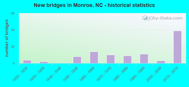
- New bridges - historical statistics
- 41920-1929
- 21930-1939
- 81950-1959
- 141960-1969
- 101970-1979
- 91980-1989
- 111990-1999
- 32000-2009
- 392010-2019
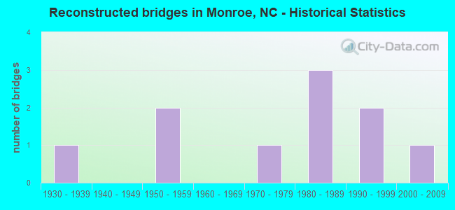
- Reconstructed bridges - Historical Statistics
- 11930-1939
- 01940-1949
- 21950-1959
- 01960-1969
- 11970-1979
- 31980-1989
- 21990-1999
- 12000-2009
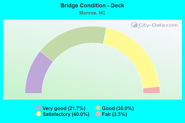
- Bridge Condition - Deck
- 21.7%Very good
- 35.0%Good
- 40.0%Satisfactory
- 3.3%Fair
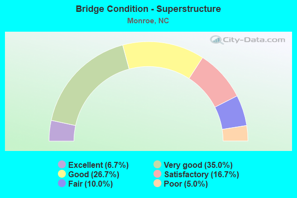
- Bridge Condition - Superstructure
- 6.7%Excellent
- 35.0%Very good
- 26.7%Good
- 16.7%Satisfactory
- 10.0%Fair
- 5.0%Poor
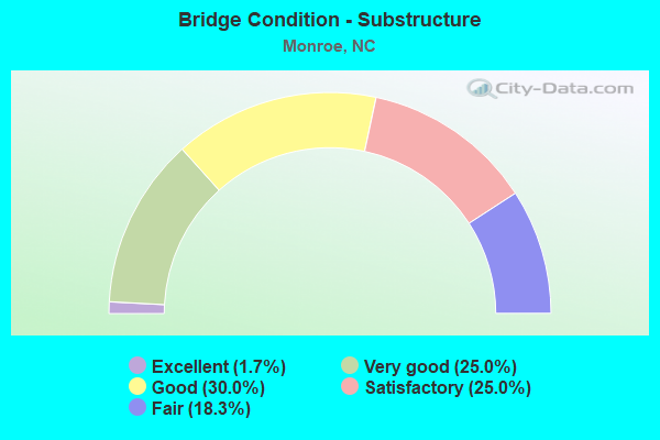
- Bridge Condition - Substructure
- 1.7%Excellent
- 25.0%Very good
- 30.0%Good
- 25.0%Satisfactory
- 18.3%Fair
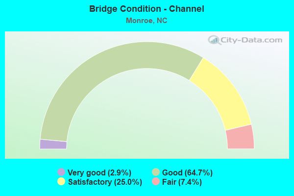
- Bridge Condition - Channel
- 2.9%Very good
- 64.7%Good
- 25.0%Satisfactory
- 7.4%Fair
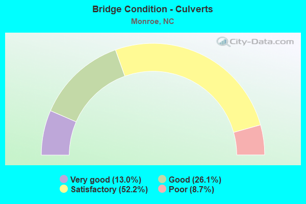
- Bridge Condition - Culverts
- 13.0%Very good
- 26.1%Good
- 52.2%Satisfactory
- 8.7%Poor
Find on map >> Show street view
Structure Number: 1790493, Location: 0.7 MI.N.OF SR1006 (Lat: 35.010556, Lng: -80.516111), Route carried "under" structure: Bypass US 74, Year Built: 2018, Structure Length: 0. m, Average Daily Traffic: 5,000 (year 2015), Truck Traffic: 14%, Features Intersected: NC200
Minimum Vertical Clearance: 5.68m (18.64ft), Kilometerpoint: 81.260, Lanes on structure: 2, Lanes under structure: 2, Material/Design: Prestressed concrete continuous, Design/Construction: Stringer/Multi-beam, Length of Maximum Span: 21.6m (70.9ft)
Find on map >> Show street view
Structure Number: 1790495, Location: 0.94 MILES EAST NC 200 (Lat: 35.008664, Lng: -80.507369), Route carried "under" structure: Bypass US 74, Year Built: 2016, Structure Length: 0. m, Average Daily Traffic: 5,000 (year 2015), Truck Traffic: 14%, Features Intersected: SR1006
Minimum Vertical Clearance: 5.33m (17.49ft), Kilometerpoint: 0.000, Lanes on structure: 2, Lanes under structure: 2, Material/Design: Prestressed concrete continuous, Design/Construction: Stringer/Multi-beam, Length of Maximum Span: 23.1m (75.8ft)
Find on map >> Show street view
Structure Number: 1790495, Location: 0.94 MILES EAST NC 200 (Lat: 35.008664, Lng: -80.507369), Route carried "under" structure: Bypass US 74, Year Built: 2016, Structure Length: 0. m, Average Daily Traffic: 5,000 (year 2015), Truck Traffic: 14%, Features Intersected: SR1006
Minimum Vertical Clearance: 5.41m (17.75ft), Kilometerpoint: 0.000, Lanes on structure: 2, Lanes under structure: 2, Material/Design: Prestressed concrete continuous, Design/Construction: Stringer/Multi-beam, Length of Maximum Span: 23.1m (75.8ft)
Find on map >> Show street view
Structure Number: 179053, Location: 0.3 MI. S. JCT. NC84 (Lat: 34.979450, Lng: -80.579606), Route carried "under" structure: State highway 2100, Year Built: 2010, Structure Length: 0. m, Average Daily Traffic: 6,900 (year 2013), Truck Traffic: 6%, Features Intersected: NC200
Minimum Vertical Clearance: 5.28m (17.32ft), Kilometerpoint: 0.000, Lanes on structure: 2, Lanes under structure: 2, Material/Design: Prestressed concrete, Design/Construction: Stringer/Multi-beam, Length of Maximum Span: 32.6m (107.0ft)
Find on map >> Show street view
Structure Number: 1790543, Location: 0.5 MI.N.OF SR1520 (Lat: 35.096111, Lng: -80.652778), Route carried "under" structure: Bypass US 74, Year Built: 2017, Structure Length: 0. m, Average Daily Traffic: 5,000 (year 2015), Truck Traffic: 12%, Features Intersected: SR1522
Minimum Vertical Clearance: 7.06m (23.16ft), Kilometerpoint: 78.151, Lanes on structure: 2, Lanes under structure: 2, Material/Design: Prestressed concrete continuous, Design/Construction: Stringer/Multi-beam, Length of Maximum Span: 26.5m (86.9ft)
Find on map >> Show street view
Structure Number: 1790543, Location: 0.5 MI.N.OF SR1520 (Lat: 35.096111, Lng: -80.652778), Route carried "under" structure: Bypass US 74, Year Built: 2017, Structure Length: 0. m, Average Daily Traffic: 5,000 (year 2015), Truck Traffic: 12%, Features Intersected: SR1522
Minimum Vertical Clearance: 7.97m (26.15ft), Kilometerpoint: 78.151, Lanes on structure: 2, Lanes under structure: 2, Material/Design: Prestressed concrete continuous, Design/Construction: Stringer/Multi-beam, Length of Maximum Span: 26.5m (86.9ft)
Find on map >> Show street view
Structure Number: 1790553, Location: 0.7 MI. E. JCT SR1514 (Lat: 35.057853, Lng: -80.582778), Route carried "under" structure: State highway 1509, Year Built: 2018, Structure Length: 0. m, Average Daily Traffic: 1,600 (year 2016), Truck Traffic: 6%, Features Intersected: US74 BYP. WBL
Minimum Vertical Clearance: 5.18m (16.99ft), Kilometerpoint: 79.706, Lanes on structure: 2, Lanes under structure: 2, Material/Design: Prestressed concrete, Design/Construction: Stringer/Multi-beam, Length of Maximum Span: 14.9m (48.9ft)
Find on map >> Show street view
Structure Number: 1790554, Location: 0.7 MI. E. JCT SR1514 (Lat: 35.057631, Lng: -80.582875), Route carried "under" structure: State highway 1509, Year Built: 2018, Structure Length: 0. m, Average Daily Traffic: 1,600 (year 2016), Truck Traffic: 6%, Features Intersected: US74 BYP. EBL
Minimum Vertical Clearance: 4.87m (15.98ft), Kilometerpoint: 79.706, Lanes on structure: 2, Lanes under structure: 2, Material/Design: Prestressed concrete, Design/Construction: Stringer/Multi-beam, Length of Maximum Span: 14.9m (48.9ft)