Bridge Statistics for Monroe, Ohio (OH)
Condition, Traffic, Stress, Structural Evaluation, Project Costs
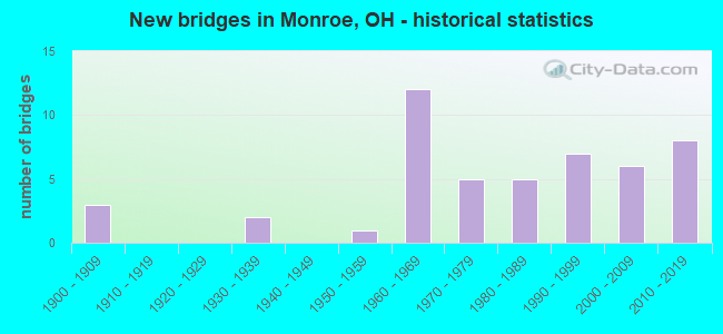
- New bridges - historical statistics
- 31900-1909
- 21930-1939
- 11950-1959
- 121960-1969
- 51970-1979
- 51980-1989
- 71990-1999
- 62000-2009
- 82010-2019

- Reconstructed bridges - Historical Statistics
- 21970-1979
- 21980-1989
- 21990-1999
- 22000-2009
- 12010-2019


- Bridge Condition - Deck
- 3.1%Excellent
- 31.3%Very good
- 34.4%Good
- 15.6%Satisfactory
- 9.4%Fair
- 6.3%Poor

- Bridge Condition - Superstructure
- 3.1%Excellent
- 46.9%Very good
- 12.5%Good
- 18.8%Satisfactory
- 12.5%Fair
- 6.3%Poor

- Bridge Condition - Substructure
- 3.1%Excellent
- 37.5%Very good
- 46.9%Good
- 9.4%Satisfactory
- 3.1%Fair

- Bridge Condition - Channel
- 11.4%Excellent
- 8.6%Very good
- 34.3%Good
- 28.6%Satisfactory
- 14.3%Fair
- 2.9%Poor

- Bridge Condition - Culverts
- 45.5%Very good
- 36.4%Good
- 18.2%Satisfactory
Find on map >> Show street view
Structure Number: 900133, Location: 0.92 MI S OF SR 63 (Lat: 39.436531, Lng: -84.435831), Route carried "on" structure: State highway 4, Year Built: 1994, Status: Open, Structure Length: 4.39m (14.40ft), Average Daily Traffic: 12,964 (year 2015), Truck Traffic: 7%, Average Future Daily Traffic: 17,994 (year 2035), Design Load: HS 20+Mod, Features Intersected: GREGORY CREEK
Minimum Vertical Clearance: 30+ m (98+ ft), Kilometerpoint: 23.818, Lanes on structure: 2, Base Highway Network: Yes, Owner: State Highway Agency, Approaching Roadway Width: 10.4m (34.1ft), Skew: 2 degrees, Material/Design: Prestressed concrete continuous, Design/Construction: Box Beam or Girders - Multiple, Number Of Spans In Main Unit: 3, Length of Maximum Span: 16.5m (54.1ft), Curb-To-Curb Width: 10.4m (34.1ft), Out-to-Out Width: 10.4m (34.1ft)
Condition: Deck: Satisfactory, Superstructure: Satisfactory, Substructure: Good, Channel: Fair, Operating Rating: 42.1 metric tons, Method Used To Determine Operating Rating: Load Factor (LF) rating reported by rating factor (RF) method using MS18 loading, Inventory Rating: 32.4 metric tons, Method Used To Determine Inventory Rating: Load Factor (LF) rating reported by rating factor (RF) method using MS18 loading, Structural Evaluation: Equal to present minimum criteria, Deck Geometry: Somewhat better than minimum adequacy, Waterway Adequacy: Equal to present desirable criteria, Approach Roadway Alignment: Equal to present desirable criteria, Designated Inspection Frequency: Every 12 months, Inspection Date: April 2021, Deck Structure Type: Concrete Cast-file-Place, Wearing Surface/Protective System: Wearing Surface: Bituminous
Find on map >> Show street view
Structure Number: 900184, Location: 0.9 TENTH MI. N. S.R. 747 (Lat: 39.434681, Lng: -84.436039), Route carried "on" structure: State highway 4, Year Built: 1957, Year Reconstructed: 1984, Status: Open, Structure Length: 4.94m (16.21ft), Average Daily Traffic: 12,964 (year 2015), Truck Traffic: 7%, Average Future Daily Traffic: 17,994 (year 2035), Design Load: HS 20, Features Intersected: GREGORY CREEK
Minimum Vertical Clearance: 30+ m (98+ ft), Kilometerpoint: 23.818, Lanes on structure: 2, Base Highway Network: Yes, Owner: State Highway Agency, Approaching Roadway Width: 11.0m (36.1ft), Skew: 3 degrees, Material/Design: Steel continuous, Design/Construction: Stringer/Multi-beam, Number Of Spans In Main Unit: 3, Length of Maximum Span: 18.6m (61.0ft), Curb-To-Curb Width: 11.0m (36.1ft), Out-to-Out Width: 11.0m (36.1ft)
Condition: Deck: Good, Superstructure: Satisfactory, Substructure: Good, Channel: Good, Operating Rating: 53.1 metric tons, Method Used To Determine Operating Rating: Load and Resistance Factor Rating (LRFR) rating reported by rating factor(RF) method using HL-93 loadings, Inventory Rating: 40.8 metric tons, Method Used To Determine Inventory Rating: Load and Resistance Factor Rating (LRFR) rating reported by rating factor(RF) method using HL-93 loadings, Structural Evaluation: Equal to present minimum criteria, Deck Geometry: Equal to present minimum criteria, Waterway Adequacy: Equal to present desirable criteria, Approach Roadway Alignment: Equal to present desirable criteria, Designated Inspection Frequency: Every 12 months, Inspection Date: March 2021, Deck Structure Type: Concrete Cast-file-Place, Wearing Surface/Protective System: Wearing Surface: Monolithic Concrete, Deck Protection: Epoxy Coated Reinforcing
Find on map >> Show street view
Structure Number: 900214, Location: .90 MI S OF SR 63 (Lat: 39.435269, Lng: -84.434569), Route carried "on" structure: State highway 4, Year Built: 1930, Year Reconstructed: 1978, Status: Posted for load, Structure Length: 1.62m (5.31ft), Average Daily Traffic: 12,964 (year 2015), Truck Traffic: 7%, Average Future Daily Traffic: 17,994 (year 2035), Design Load: HS 25 or greater, Features Intersected: COLDWATER CREEK
Minimum Vertical Clearance: 30+ m (98+ ft), Kilometerpoint: 23.947, Lanes on structure: 2, Base Highway Network: Yes, Owner: State Highway Agency, Approaching Roadway Width: 9.8m (32.2ft), Skew: 1 degrees, Material/Design: Prestressed concrete, Design/Construction: Box Beam or Girders - Multiple, Number Of Spans In Main Unit: 1, Length of Maximum Span: 15.9m (52.2ft), Curb-To-Curb Width: 9.8m (32.2ft), Out-to-Out Width: 10.6m (34.8ft)
Condition: Deck: Poor, Superstructure: Poor, Substructure: Good, Channel: Fair, Operating Rating: 25.9 metric tons, Method Used To Determine Operating Rating: Load and Resistance Factor Rating (LRFR) rating reported by rating factor(RF) method using HL-93 loadings, Inventory Rating: 19.4 metric tons, Method Used To Determine Inventory Rating: Load and Resistance Factor Rating (LRFR) rating reported by rating factor(RF) method using HL-93 loadings, Structural Evaluation: Meets minimum limits, Deck Geometry: Meets minimum limits, Waterway Adequacy: Equal to present desirable criteria, Approach Roadway Alignment: Equal to present desirable criteria, Bridge Posting: Required (Relationship of Operating Rating to Maximum Legal Load: 20.0 - 29.9% below), Designated Inspection Frequency: Every 12 months, Other Special Inspection Frequency: Every 6 months, Inspection Date: March 2021, Other Special Inspection Date: March 2021, Deck Structure Type: Concrete Cast-file-Place, Wearing Surface/Protective System: Wearing Surface: Bituminous
Find on map >> Show street view
Structure Number: 900249, Location: SR 4 SB OVER SR 63 (Lat: 39.445550, Lng: -84.425189), Route carried "on" structure: State highway 4, Year Built: 1969, Year Reconstructed: 2021, Status: Open, Structure Length: 5.75m (18.86ft), Average Daily Traffic: 12,622 (year 2015), Truck Traffic: 7%, Average Future Daily Traffic: 17,519 (year 2035), Design Load: HS 20, Features Intersected: RAMP=S4*S-S63*E;S63*W
Minimum Vertical Clearance: 30+ m (98+ ft), Kilometerpoint: 25.395, Lanes on structure: 2, Lanes under structure: 2, Base Highway Network: Yes, Owner: State Highway Agency, Approaching Roadway Width: 9.8m (32.2ft), Skew: 3 degrees, Material/Design: Steel continuous, Design/Construction: Stringer/Multi-beam, Number Of Spans In Main Unit: 4, Length of Maximum Span: 16.0m (52.5ft), Curb-To-Curb Width: 14.5m (47.6ft), Out-to-Out Width: 15.9m (52.2ft)
Condition: Deck: Good, Superstructure: Very good, Substructure: Very good, Operating Rating: 66.7 metric tons, Method Used To Determine Operating Rating: Load Factor (LF) rating reported by rating factor (RF) method using MS18 loading, Inventory Rating: 40.2 metric tons, Method Used To Determine Inventory Rating: Load Factor (LF) rating reported by rating factor (RF) method using MS18 loading, Structural Evaluation: Equal to present desirable criteria, Deck Geometry: Superior to present desirable criteria, Underclear: Equal to present minimum criteria, Approach Roadway Alignment: Equal to present desirable criteria, Designated Inspection Frequency: Every 12 months, Inspection Date: October 2021, Deck Structure Type: Concrete Cast-file-Place, Wearing Surface/Protective System: Wearing Surface: Integral Concrete
Find on map >> Show street view
Structure Number: 900273, Location: NB RT 4 OVER SR 63 (Lat: 39.445519, Lng: -84.424850), Route carried "on" structure: State highway 4, Year Built: 1969, Year Reconstructed: 2021, Status: Open, Structure Length: 5.70m (18.70ft), Average Daily Traffic: 12,622 (year 2015), Truck Traffic: 7%, Average Future Daily Traffic: 17,519 (year 2035), Design Load: HS 20, Features Intersected: RAMP=S4*S-S63*E;S63*W
Minimum Vertical Clearance: 30+ m (98+ ft), Kilometerpoint: 25.395, Lanes on structure: 2, Lanes under structure: 2, Base Highway Network: Yes, Owner: State Highway Agency, Approaching Roadway Width: 9.8m (32.2ft), Skew: 3 degrees, Material/Design: Steel continuous, Design/Construction: Stringer/Multi-beam, Number Of Spans In Main Unit: 4, Length of Maximum Span: 15.9m (52.2ft), Curb-To-Curb Width: 11.5m (37.7ft), Out-to-Out Width: 12.9m (42.3ft)
Condition: Deck: Good, Superstructure: Very good, Substructure: Very good, Operating Rating: 68.0 metric tons, Method Used To Determine Operating Rating: Load Factor (LF) rating reported by rating factor (RF) method using MS18 loading, Inventory Rating: 40.8 metric tons, Method Used To Determine Inventory Rating: Load Factor (LF) rating reported by rating factor (RF) method using MS18 loading, Structural Evaluation: Equal to present desirable criteria, Deck Geometry: Equal to present minimum criteria, Underclear: Meets minimum limits, Approach Roadway Alignment: Equal to present desirable criteria, Designated Inspection Frequency: Every 12 months, Inspection Date: October 2021, Deck Structure Type: Concrete Cast-file-Place, Wearing Surface/Protective System: Wearing Surface: Integral Concrete
Find on map >> Show street view
Structure Number: 901954, Location: 1.66 MI S BUT-WAR CO LINE (Lat: 39.413050, Lng: -84.352719), Route carried "on" structure: County highway 23, Year Built: 1960, Year Reconstructed: 2008, Status: Open, Structure Length: 8.68m (28.48ft), Average Daily Traffic: 1,459 (year 2016), Truck Traffic: 7%, Average Future Daily Traffic: 2,025 (year 2036), Design Load: H 15, Features Intersected: IR-75, Facility Carried by Structure: KYLES STA. RD TR-
Minimum Vertical Clearance: 30+ m (98+ ft), Kilometerpoint: 1.268, Lanes on structure: 2, Lanes under structure: 8, Owner: State Highway Agency, Approaching Roadway Width: 11.0m (36.1ft), Skew: 2 degrees, Material/Design: Steel continuous, Design/Construction: Stringer/Multi-beam, Number Of Spans In Main Unit: 4, Length of Maximum Span: 26.8m (87.9ft), Curb-To-Curb Width: 8.5m (27.9ft), Out-to-Out Width: 9.4m (30.8ft)
Condition: Deck: Good, Superstructure: Good, Substructure: Good, Operating Rating: 42.1 metric tons, Method Used To Determine Operating Rating: Allowable Stress (AS) rating reported by rating factor (RF) method using MS18 loading, Inventory Rating: 32.4 metric tons, Method Used To Determine Inventory Rating: Allowable Stress (AS) rating reported by rating factor (RF) method using MS18 loading, Structural Evaluation: Better than present minimum criteria, Deck Geometry: Somewhat better than minimum adequacy, Underclear: Equal to present minimum criteria, Approach Roadway Alignment: Equal to present desirable criteria, Designated Inspection Frequency: Every 24 months, Inspection Date: March 2021, Deck Structure Type: Concrete Cast-file-Place, Wearing Surface/Protective System: Wearing Surface: Monolithic Concrete, Membrane: Epoxy, Deck Protection: Epoxy Coated Reinforcing
Find on map >> Show street view
Structure Number: 90202, Location: .34 MI S BUT-WAR CO LINE (Lat: 39.430311, Lng: -84.341819), Route carried "on" structure: Interstate 75, Year Built: 2010, Status: Open, Structure Length: 5.06m (16.60ft), Average Daily Traffic: 113,089 (year 2015), Truck Traffic: 16%, Average Future Daily Traffic: 156,968 (year 2035), Design Load: HS 25 or greater, Features Intersected: MASON ROAD
Minimum Vertical Clearance: 30+ m (98+ ft), Kilometerpoint: 17.558, Lanes on structure: 9, Lanes under structure: 2, Base Highway Network: Yes, Owner: State Highway Agency, Approaching Roadway Width: 52.7m (172.9ft), Skew: 31 degrees, Material/Design: Steel continuous, Design/Construction: Stringer/Multi-beam, Number Of Spans In Main Unit: 3, Length of Maximum Span: 20.7m (67.9ft), Curb-To-Curb Width: 50.6m (166.0ft), Out-to-Out Width: 52.7m (172.9ft)
Condition: Deck: Very good, Superstructure: Very good, Substructure: Very good, Operating Rating: 42.1 metric tons, Method Used To Determine Operating Rating: Load Factor (LF) rating reported by rating factor (RF) method using MS18 loading, Inventory Rating: 32.4 metric tons, Method Used To Determine Inventory Rating: Load Factor (LF) rating reported by rating factor (RF) method using MS18 loading, Structural Evaluation: Equal to present desirable criteria, Deck Geometry: Superior to present desirable criteria, Underclear: Somewhat better than minimum adequacy, Approach Roadway Alignment: Equal to present minimum criteria, Designated Inspection Frequency: Every 24 months, Inspection Date: March 2021, Deck Structure Type: Concrete Cast-file-Place, Wearing Surface/Protective System: Wearing Surface: Monolithic Concrete, Deck Protection: Epoxy Coated Reinforcing
Find on map >> Show street view
Structure Number: 930989, Location: .3 MI S OF CR 23 (Lat: 39.410939, Lng: -84.385839), Route carried "on" structure: County highway C0134, Year Built: 1938, Status: Open, Structure Length: 0.97m (3.18ft), Average Daily Traffic: 643 (year 2015), Truck Traffic: 7%, Average Future Daily Traffic: 892 (year 2038), Design Load: HS 20, Features Intersected: PANTHER RUN CREEK, Facility Carried by Structure: YANKEE RD
Minimum Vertical Clearance: 30+ m (98+ ft), Kilometerpoint: 4.458, Lanes on structure: 2, Owner: County Highway Agency, Approaching Roadway Width: 9.1m (29.9ft), Skew: 3 degrees, Material/Design: Concrete, Design/Construction: Slab, Number Of Spans In Main Unit: 1, Length of Maximum Span: 8.8m (28.9ft), Curb-To-Curb Width: 9.5m (31.2ft), Out-to-Out Width: 10.9m (35.8ft)
Condition: Deck: Satisfactory, Superstructure: Satisfactory, Substructure: Good, Channel: Fair, Operating Rating: 40.8 metric tons, Method Used To Determine Operating Rating: Field evaluation and documented engineering judgment, Inventory Rating: 32.7 metric tons, Method Used To Determine Inventory Rating: Field evaluation and documented engineering judgment, Structural Evaluation: Equal to present minimum criteria, Deck Geometry: Equal to present minimum criteria, Waterway Adequacy: Equal to present desirable criteria, Approach Roadway Alignment: Equal to present desirable criteria, Designated Inspection Frequency: Every 12 months, Inspection Date: November 2021, Deck Structure Type: Concrete Cast-file-Place, Wearing Surface/Protective System: Wearing Surface: Bituminous
Find on map >> Show street view
Structure Number: 93245, Location: .3 MI E OF TR 134 (Lat: 39.433369, Lng: -84.378639), Route carried "on" structure: County highway T0135, Year Built: 1986, Status: Open, Structure Length: 0.79m (2.59ft), Average Daily Traffic: 797 (year 2015), Truck Traffic: 8%, Average Future Daily Traffic: 1,106 (year 2037), Design Load: HS 20+Mod, Features Intersected: COLD WATER CREEK, Facility Carried by Structure: CARSON RD
Minimum Vertical Clearance: 30+ m (98+ ft), Kilometerpoint: 0.435, Lanes on structure: 2, Owner: County Highway Agency, Approaching Roadway Width: 9.1m (29.9ft), Material/Design: Concrete, Design/Construction: Box Beam or Girders - Multiple, Number Of Spans In Main Unit: 1, Length of Maximum Span: 7.3m (24.0ft), Curb-To-Curb Width: 9.1m (29.9ft), Out-to-Out Width: 9.1m (29.9ft)
Condition: Deck: Very good, Superstructure: Very good, Substructure: Good, Channel: Satisfactory, Operating Rating: 40.8 metric tons, Method Used To Determine Operating Rating: Field evaluation and documented engineering judgment, Inventory Rating: 32.7 metric tons, Method Used To Determine Inventory Rating: Field evaluation and documented engineering judgment, Structural Evaluation: Better than present minimum criteria, Deck Geometry: Equal to present minimum criteria, Waterway Adequacy: Equal to present desirable criteria, Approach Roadway Alignment: Better than present minimum criteria, Designated Inspection Frequency: Every 24 months, Inspection Date: March 2020, Deck Structure Type: Concrete Cast-file-Place, Wearing Surface/Protective System: Wearing Surface: Bituminous
Find on map >> Show street view
Structure Number: 932604, Location: 0.9 MI W OF MAUDS HUGHES (Lat: 39.416900, Lng: -84.425311), Route carried "on" structure: County highway C0023, Year Built: 1969, Year Reconstructed: 1989, Status: Open, Structure Length: 3.41m (11.19ft), Average Daily Traffic: 3,570 (year 2018), Truck Traffic: 5%, Average Future Daily Traffic: 3,091 (year 2038), Design Load: HS 20+Mod, Features Intersected: GREGORY CREEK, Facility Carried by Structure: KYLES STATION RD
Minimum Vertical Clearance: 30+ m (98+ ft), Kilometerpoint: 3.685, Lanes on structure: 2, Owner: County Highway Agency, Approaching Roadway Width: 7.3m (24.0ft), Material/Design: Prestressed concrete continuous, Design/Construction: Box Beam or Girders - Multiple, Number Of Spans In Main Unit: 3, Length of Maximum Span: 12.5m (41.0ft), Curb-To-Curb Width: 8.5m (27.9ft), Out-to-Out Width: 8.5m (27.9ft)
Condition: Deck: Poor, Superstructure: Poor, Substructure: Satisfactory, Channel: Good, Operating Rating: 42.1 metric tons, Method Used To Determine Operating Rating: Load Factor (LF) rating reported by rating factor (RF) method using MS18 loading, Inventory Rating: 25.9 metric tons, Method Used To Determine Inventory Rating: Load Factor (LF) rating reported by rating factor (RF) method using MS18 loading, Structural Evaluation: Meets minimum limits, Deck Geometry: Meets minimum limits, Waterway Adequacy: Better than present minimum criteria, Approach Roadway Alignment: Better than present minimum criteria, Designated Inspection Frequency: Every 12 months, Inspection Date: November 2021, Deck Structure Type: Concrete Cast-file-Place, Wearing Surface/Protective System: Wearing Surface: Bituminous, Membrane: Preformed Fabric
Find on map >> Show street view
Structure Number: 932841, Location: 0.1 MI W OF MAUDS HUGHES (Lat: 39.401719, Lng: -84.412569), Route carried "on" structure: County highway C0022, Year Built: 1987, Status: Open, Structure Length: 4.39m (14.40ft), Average Daily Traffic: 4,320 (year 2018), Truck Traffic: 5%, Average Future Daily Traffic: 3,091 (year 2037), Design Load: HS 20+Mod, Features Intersected: Norfolk South'n RR, Facility Carried by Structure: MILLIKIN RD
Minimum Vertical Clearance: 30+ m (98+ ft), Kilometerpoint: 7.966, Lanes on structure: 2, Owner: County Highway Agency, Approaching Roadway Width: 8.5m (27.9ft), Material/Design: Prestressed concrete continuous, Design/Construction: Box Beam or Girders - Multiple, Number Of Spans In Main Unit: 3, Length of Maximum Span: 16.8m (55.1ft), Curb-To-Curb Width: 8.5m (27.9ft), Out-to-Out Width: 8.5m (27.9ft)
Condition: Deck: Satisfactory, Superstructure: Satisfactory, Substructure: Good, Operating Rating: 48.6 metric tons, Method Used To Determine Operating Rating: Load Factor (LF) rating reported by rating factor (RF) method using MS18 loading, Inventory Rating: 19.4 metric tons, Method Used To Determine Inventory Rating: Load Factor (LF) rating reported by rating factor (RF) method using MS18 loading, Structural Evaluation: Somewhat better than minimum adequacy, Deck Geometry: Meets minimum limits, Underclear: Somewhat better than minimum adequacy, Approach Roadway Alignment: Better than present minimum criteria, Designated Inspection Frequency: Every 12 months, Inspection Date: November 2021, Deck Structure Type: Concrete Cast-file-Place, Wearing Surface/Protective System: Wearing Surface: Bituminous, Membrane: Built-up
Find on map >> Show street view
Structure Number: 933002, Location: 0.18 MI S OF KYLES STATIO (Lat: 39.412811, Lng: -84.395919), Route carried "on" structure: County highway T3095, Year Built: 2017, Status: Open, Structure Length: 1.22m (4.00ft), Average Daily Traffic: 951 (year 2015), Truck Traffic: 5%, Average Future Daily Traffic: 1,320 (year 2040), Design Load: HL 93, Features Intersected: PANTHER RUN, Facility Carried by Structure: Rodeo Drive
Minimum Vertical Clearance: 30+ m (98+ ft), Kilometerpoint: 0.327, Lanes on structure: 2, Owner: County Highway Agency, Approaching Roadway Width: 7.0m (23.0ft), Material/Design: Concrete, Design/Construction: Culvert, Number Of Spans In Main Unit: 1, Length of Maximum Span: 12.2m (40.0ft)
Condition: Channel: Excellent, Culverts: Very good, Operating Rating: 68.0 metric tons, Method Used To Determine Operating Rating: Load and Resistance Factor Rating (LRFR) rating reported by rating factor(RF) method using HL-93 loadings, Inventory Rating: 55.1 metric tons, Method Used To Determine Inventory Rating: Load and Resistance Factor Rating (LRFR) rating reported by rating factor(RF) method using HL-93 loadings, Structural Evaluation: Equal to present desirable criteria, Waterway Adequacy: Superior to present desirable criteria, Approach Roadway Alignment: Superior to present desirable criteria, Designated Inspection Frequency: Every 24 months, Inspection Date: March 2020
Find on map >> Show street view
Structure Number: 933465, Location: .5 MI S OF SR 63 (Lat: 39.437089, Lng: -84.389011), Route carried "on" structure: County highway T0134, Year Built: 1988, Status: Open, Structure Length: 0.76m (2.49ft), Average Daily Traffic: 2,350 (year 2018), Truck Traffic: 5%, Average Future Daily Traffic: 6,325 (year 2037), Design Load: HS 20, Features Intersected: COLD WATER CREEK, Facility Carried by Structure: YANKEE RD
Minimum Vertical Clearance: 30+ m (98+ ft), Kilometerpoint: 7.838, Lanes on structure: 2, Owner: County Highway Agency, Approaching Roadway Width: 9.1m (29.9ft), Material/Design: Concrete, Design/Construction: Box Beam or Girders - Multiple, Number Of Spans In Main Unit: 1, Length of Maximum Span: 7.0m (23.0ft), Curb-To-Curb Width: 9.1m (29.9ft), Out-to-Out Width: 9.1m (29.9ft)
Condition: Deck: Fair, Superstructure: Fair, Substructure: Good, Channel: Satisfactory, Operating Rating: 68.0 metric tons, Method Used To Determine Operating Rating: Load Factor (LF) rating reported by rating factor (RF) method using MS18 loading, Inventory Rating: 42.1 metric tons, Method Used To Determine Inventory Rating: Load Factor (LF) rating reported by rating factor (RF) method using MS18 loading, Structural Evaluation: Somewhat better than minimum adequacy, Deck Geometry: Meets minimum limits, Waterway Adequacy: Equal to present desirable criteria, Approach Roadway Alignment: Equal to present desirable criteria, Designated Inspection Frequency: Every 12 months, Inspection Date: November 2021, Deck Structure Type: Concrete Cast-file-Place, Wearing Surface/Protective System: Wearing Surface: Bituminous, Membrane: Preformed Fabric
Find on map >> Show street view
Structure Number: 934542, Location: .2 MI N OF TODHUNTER RD (Lat: 39.460700, Lng: -84.350061), Route carried "on" structure: County highway C0019, Year Built: 1976, Year Reconstructed: 1996, Status: Open, Structure Length: 3.05m (10.01ft), Average Daily Traffic: 16,665 (year 2019), Truck Traffic: 7%, Average Future Daily Traffic: 597 (year 2039), Design Load: HS 20+Mod, Features Intersected: MILLERS CREEK, Facility Carried by Structure: CIN DAYTON RD
Minimum Vertical Clearance: 30+ m (98+ ft), Kilometerpoint: 19.698, Lanes on structure: 2, Owner: County Highway Agency, Approaching Roadway Width: 13.4m (44.0ft), Skew: 2 degrees, Material/Design: Concrete continuous, Design/Construction: Slab, Number Of Spans In Main Unit: 3, Length of Maximum Span: 11.6m (38.1ft), Curb-To-Curb Width: 12.2m (40.0ft), Out-to-Out Width: 12.2m (40.0ft)
Condition: Deck: Good, Superstructure: Good, Substructure: Fair, Channel: Good, Operating Rating: 58.3 metric tons, Method Used To Determine Operating Rating: Load Factor (LF) rating reported by rating factor (RF) method using MS18 loading, Inventory Rating: 35.6 metric tons, Method Used To Determine Inventory Rating: Load Factor (LF) rating reported by rating factor (RF) method using MS18 loading, Structural Evaluation: Somewhat better than minimum adequacy, Deck Geometry: Somewhat better than minimum adequacy, Waterway Adequacy: Equal to present minimum criteria, Approach Roadway Alignment: Equal to present desirable criteria, Designated Inspection Frequency: Every 12 months, Inspection Date: November 2021, Deck Structure Type: Concrete Cast-file-Place, Wearing Surface/Protective System: Wearing Surface: Bituminous, Membrane: Built-up
Find on map >> Show street view
Structure Number: 934615, Location: .01 MI E OF SALZMAN (Lat: 39.430711, Lng: -84.402969), Route carried "on" structure: County highway T0137, Year Built: 1977, Status: Open, Structure Length: 4.60m (15.09ft), Average Daily Traffic: 2,210 (year 2018), Truck Traffic: 8%, Average Future Daily Traffic: 1,817 (year 2037), Design Load: HS 20+Mod, Features Intersected: Norfolk South'n RR, Facility Carried by Structure: HANKINS RD
Minimum Vertical Clearance: 30+ m (98+ ft), Kilometerpoint: 2.816, Lanes on structure: 2, Owner: County Highway Agency, Approaching Roadway Width: 9.8m (32.2ft), Skew: 1 degrees, Material/Design: Steel continuous, Design/Construction: Stringer/Multi-beam, Number Of Spans In Main Unit: 3, Length of Maximum Span: 17.4m (57.1ft), Curb-To-Curb Width: 8.5m (27.9ft), Out-to-Out Width: 9.6m (31.5ft)
Condition: Deck: Good, Superstructure: Fair, Substructure: Very good, Operating Rating: 55.1 metric tons, Method Used To Determine Operating Rating: Load Factor (LF) rating reported by rating factor (RF) method using MS18 loading, Inventory Rating: 32.4 metric tons, Method Used To Determine Inventory Rating: Load Factor (LF) rating reported by rating factor (RF) method using MS18 loading, Structural Evaluation: Somewhat better than minimum adequacy, Deck Geometry: Meets minimum limits, Underclear: Equal to present minimum criteria, Approach Roadway Alignment: Better than present minimum criteria, Designated Inspection Frequency: Every 12 months, Inspection Date: November 2021, Deck Structure Type: Concrete Cast-file-Place, Wearing Surface/Protective System: Wearing Surface: Bituminous, Membrane: Built-up
Find on map >> Show street view
Structure Number: 935166, Location: .1 MI EAST OF LESOUD-WEST (Lat: 39.402539, Lng: -84.429131), Route carried "on" structure: County highway C0022, Year Built: 1994, Status: Open, Structure Length: 0.85m (2.79ft), Average Daily Traffic: 351 (year 2015), Truck Traffic: 7%, Average Future Daily Traffic: 487 (year 2037), Design Load: HS 20, Features Intersected: STONY RUN, Facility Carried by Structure: MILLIKIN
Minimum Vertical Clearance: 30+ m (98+ ft), Kilometerpoint: 6.518, Lanes on structure: 2, Owner: County Highway Agency, Approaching Roadway Width: 6.7m (22.0ft), Skew: 2 degrees, Material/Design: Concrete, Design/Construction: Frame, Number Of Spans In Main Unit: 1, Length of Maximum Span: 7.9m (25.9ft), Curb-To-Curb Width: 9.8m (32.2ft), Out-to-Out Width: 12.2m (40.0ft)
Condition: Deck: Very good, Superstructure: Very good, Substructure: Good, Channel: Satisfactory, Operating Rating: 64.8 metric tons, Method Used To Determine Operating Rating: Load Factor (LF) rating reported by rating factor (RF) method using MS18 loading, Inventory Rating: 45.4 metric tons, Method Used To Determine Inventory Rating: Load Factor (LF) rating reported by rating factor (RF) method using MS18 loading, Structural Evaluation: Better than present minimum criteria, Deck Geometry: Better than present minimum criteria, Waterway Adequacy: Better than present minimum criteria, Approach Roadway Alignment: Somewhat better than minimum adequacy, Designated Inspection Frequency: Every 24 months, Inspection Date: March 2020, Deck Structure Type: Concrete Cast-file-Place, Wearing Surface/Protective System: Wearing Surface: Bituminous
Find on map >> Show street view
Structure Number: 935395, Location: 0.2 MI S OF CR 23 (Lat: 39.412581, Lng: -84.408281), Route carried "on" structure: County highway T0138, Year Built: 1995, Status: Open, Structure Length: 1.19m (3.90ft), Average Daily Traffic: 477 (year 2015), Truck Traffic: 8%, Average Future Daily Traffic: 662 (year 2037), Design Load: HS 20+Mod, Features Intersected: PANTHER RUN, Facility Carried by Structure: MAUDS HUGHES RD
Minimum Vertical Clearance: 30+ m (98+ ft), Kilometerpoint: 6.067, Lanes on structure: 2, Owner: County Highway Agency, Approaching Roadway Width: 12.2m (40.0ft), Material/Design: Prestressed concrete, Design/Construction: Box Beam or Girders - Multiple, Number Of Spans In Main Unit: 1, Length of Maximum Span: 10.7m (35.1ft), Curb-To-Curb Width: 8.5m (27.9ft), Out-to-Out Width: 9.1m (29.9ft)
Condition: Deck: Very good, Superstructure: Very good, Substructure: Very good, Channel: Excellent, Operating Rating: 58.3 metric tons, Method Used To Determine Operating Rating: Load Factor (LF) rating reported by rating factor (RF) method using MS18 loading, Inventory Rating: 35.6 metric tons, Method Used To Determine Inventory Rating: Load Factor (LF) rating reported by rating factor (RF) method using MS18 loading, Structural Evaluation: Equal to present desirable criteria, Deck Geometry: Somewhat better than minimum adequacy, Waterway Adequacy: Superior to present desirable criteria, Approach Roadway Alignment: Equal to present minimum criteria, Designated Inspection Frequency: Every 24 months, Inspection Date: March 2020, Deck Structure Type: Concrete Cast-file-Place, Wearing Surface/Protective System: Wearing Surface: Bituminous, Membrane: Preformed Fabric, Deck Protection: Bituminous
Find on map >> Show street view
Structure Number: 935557, Location: 0.2 MILES S OF SR 63 (Lat: 39.442331, Lng: -84.388461), Route carried "on" structure: County highway T0134, Year Built: 1995, Status: Open, Structure Length: 0.76m (2.49ft), Average Daily Traffic: 10,177 (year 2015), Truck Traffic: 5%, Average Future Daily Traffic: 14,126 (year 2037), Design Load: HS 20+Mod, Features Intersected: Tributary of Dicks Creek, Facility Carried by Structure: YANKEE ROAD
Minimum Vertical Clearance: 30+ m (98+ ft), Kilometerpoint: 8.401, Lanes on structure: 2, Owner: County Highway Agency, Approaching Roadway Width: 12.2m (40.0ft), Material/Design: Concrete, Design/Construction: Culvert, Number Of Spans In Main Unit: 1, Length of Maximum Span: 6.3m (20.7ft)
Condition: Channel: Satisfactory, Culverts: Good, Operating Rating: 40.8 metric tons, Method Used To Determine Operating Rating: Field evaluation and documented engineering judgment, Inventory Rating: 32.7 metric tons, Method Used To Determine Inventory Rating: Field evaluation and documented engineering judgment, Structural Evaluation: Better than present minimum criteria, Waterway Adequacy: Superior to present desirable criteria, Approach Roadway Alignment: Better than present minimum criteria, Designated Inspection Frequency: Every 24 months, Inspection Date: March 2020, Wearing Surface/Protective System: Membrane: Preformed Fabric
Find on map >> Show street view
Structure Number: 935662, Location: 0.1 MI. S. OF TR 22 (Lat: 39.401200, Lng: -84.430700), Route carried "on" structure: County highway T0131, Year Built: 1996, Status: Open, Structure Length: 1.07m (3.51ft), Average Daily Traffic: 7,966 (year 2015), Truck Traffic: 7%, Average Future Daily Traffic: 11,057 (year 2037), Design Load: HS 20+Mod, Features Intersected: GREGORY CREEK BRANCH, Facility Carried by Structure: LES. W. CHEST. RD.
Minimum Vertical Clearance: 30+ m (98+ ft), Kilometerpoint: 8.288, Lanes on structure: 2, Owner: County Highway Agency, Approaching Roadway Width: 11.0m (36.1ft), Material/Design: Prestressed concrete, Design/Construction: Box Beam or Girders - Multiple, Number Of Spans In Main Unit: 1, Length of Maximum Span: 9.1m (29.9ft), Curb-To-Curb Width: 9.8m (32.2ft), Out-to-Out Width: 10.7m (35.1ft)
Condition: Deck: Very good, Superstructure: Very good, Substructure: Good, Channel: Satisfactory, Operating Rating: 68.0 metric tons, Method Used To Determine Operating Rating: Load Factor (LF) rating reported by rating factor (RF) method using MS18 loading, Inventory Rating: 42.1 metric tons, Method Used To Determine Inventory Rating: Load Factor (LF) rating reported by rating factor (RF) method using MS18 loading, Structural Evaluation: Better than present minimum criteria, Deck Geometry: Meets minimum limits, Waterway Adequacy: Equal to present desirable criteria, Approach Roadway Alignment: Better than present minimum criteria, Designated Inspection Frequency: Every 24 months, Inspection Date: March 2020, Deck Structure Type: Concrete Cast-file-Place, Wearing Surface/Protective System: Wearing Surface: Bituminous, Membrane: Built-up
Find on map >> Show street view
Structure Number: 935948, Location: .03 MI S OF HANKINS (Lat: 39.431389, Lng: -84.435750), Route carried "on" structure: County highway T0131, Year Built: 1999, Status: Open, Structure Length: 3.81m (12.50ft), Average Daily Traffic: 2,100 (year 2015), Truck Traffic: 3%, Average Future Daily Traffic: 2,915 (year 2037), Design Load: HS 20, Features Intersected: GREGORY CREEK, Facility Carried by Structure: Lesourdsville W. C
Minimum Vertical Clearance: 30+ m (98+ ft), Kilometerpoint: 11.796, Lanes on structure: 2, Owner: County Highway Agency, Approaching Roadway Width: 10.4m (34.1ft), Material/Design: Prestressed concrete continuous, Design/Construction: Box Beam or Girders - Multiple, Number Of Spans In Main Unit: 3, Length of Maximum Span: 12.2m (40.0ft), Curb-To-Curb Width: 10.4m (34.1ft), Out-to-Out Width: 10.4m (34.1ft)
Condition: Deck: Fair, Superstructure: Fair, Substructure: Good, Channel: Good, Operating Rating: 55.1 metric tons, Method Used To Determine Operating Rating: Load Factor (LF) rating reported by rating factor (RF) method using MS18 loading, Inventory Rating: 32.4 metric tons, Method Used To Determine Inventory Rating: Load Factor (LF) rating reported by rating factor (RF) method using MS18 loading, Structural Evaluation: Somewhat better than minimum adequacy, Deck Geometry: Somewhat better than minimum adequacy, Waterway Adequacy: Superior to present desirable criteria, Approach Roadway Alignment: Superior to present desirable criteria, Designated Inspection Frequency: Every 12 months, Inspection Date: December 2021, Deck Structure Type: Concrete Cast-file-Place, Wearing Surface/Protective System: Wearing Surface: Bituminous
Find on map >> Show street view
Structure Number: 93617, Location: 0.17 MI N JOANNE DRIVE (Lat: 39.414339, Lng: -84.402019), Route carried "on" structure: County highway T3067, Year Built: 1900, Status: Open, Structure Length: 1.16m (3.81ft), Average Daily Traffic: 951 (year 2015), Truck Traffic: 5%, Average Future Daily Traffic: 1,320 (year 2037), Design Load: HS 20, Features Intersected: PANTHER RUN CREEK, Facility Carried by Structure: JOANNE DRIVE
Minimum Vertical Clearance: 30+ m (98+ ft), Kilometerpoint: 0.274, Lanes on structure: 2, Owner: County Highway Agency, Approaching Roadway Width: 7.3m (24.0ft), Material/Design: Concrete, Design/Construction: Culvert, Number Of Spans In Main Unit: 1, Length of Maximum Span: 11.6m (38.1ft)
Condition: Channel: Fair, Culverts: Very good, Operating Rating: 94.0 metric tons, Method Used To Determine Operating Rating: Load Factor (LF) rating reported by rating factor (RF) method using MS18 loading, Inventory Rating: 61.6 metric tons, Method Used To Determine Inventory Rating: Load Factor (LF) rating reported by rating factor (RF) method using MS18 loading, Structural Evaluation: Equal to present desirable criteria, Waterway Adequacy: Superior to present desirable criteria, Approach Roadway Alignment: Superior to present desirable criteria, Designated Inspection Frequency: Every 24 months, Inspection Date: March 2020
Find on map >> Show street view
Structure Number: 936537, Location: 1.25 MI E. OF SR 747 (Lat: 39.402189, Lng: -84.422039), Route carried "on" structure: County highway C0022, Year Built: 2005, Status: Open, Structure Length: 2.44m (8.01ft), Average Daily Traffic: 8,765 (year 2015), Truck Traffic: 5%, Average Future Daily Traffic: 12,166 (year 2037), Design Load: HS 25 or greater, Features Intersected: GREGORY CREEK, Facility Carried by Structure: Millikin Road
Minimum Vertical Clearance: 30+ m (98+ ft), Kilometerpoint: 7.145, Lanes on structure: 2, Owner: County Highway Agency, Approaching Roadway Width: 6.7m (22.0ft), Material/Design: Prestressed concrete, Design/Construction: Box Beam or Girders - Multiple, Number Of Spans In Main Unit: 1, Length of Maximum Span: 24.4m (80.1ft), Curb-To-Curb Width: 11.0m (36.1ft), Out-to-Out Width: 11.0m (36.1ft)
Condition: Deck: Very good, Superstructure: Very good, Substructure: Good, Channel: Excellent, Operating Rating: 64.8 metric tons, Method Used To Determine Operating Rating: Load Factor (LF) rating reported by rating factor (RF) method using MS18 loading, Inventory Rating: 38.9 metric tons, Method Used To Determine Inventory Rating: Load Factor (LF) rating reported by rating factor (RF) method using MS18 loading, Structural Evaluation: Better than present minimum criteria, Deck Geometry: Meets minimum limits, Waterway Adequacy: Superior to present desirable criteria, Approach Roadway Alignment: Superior to present desirable criteria, Designated Inspection Frequency: Every 24 months, Inspection Date: March 2020, Deck Structure Type: Concrete Cast-file-Place, Wearing Surface/Protective System: Wearing Surface: Bituminous, Membrane: Preformed Fabric, Deck Protection: Epoxy Coated Reinforcing
Find on map >> Show street view
Structure Number: 96162, Location: .568 MI S OF SR 63 (Lat: 39.431331, Lng: -84.323811), Route carried "on" structure: City street GATEW, Year Built: 2008, Status: Open, Structure Length: 0.98m (3.22ft), Average Daily Traffic: 1,491 (year 2021), Truck Traffic: 5%, Average Future Daily Traffic: 2,070 (year 2041), Design Load: HS 25 or greater, Features Intersected: STREAM
Minimum Vertical Clearance: 30+ m (98+ ft), Kilometerpoint: 0.097, Lanes on structure: 5, Owner: City or Municipal Highway Agency, Approaching Roadway Width: 19.5m (64.0ft), Material/Design: Concrete, Design/Construction: Culvert, Number Of Spans In Main Unit: 1, Length of Maximum Span: 9.1m (29.9ft), Curb or Sidewalk Widths: Left: 1.5m (4.9ft), Right: 0.0m
Condition: Channel: Good, Culverts: Good, Operating Rating: 48.6 metric tons, Method Used To Determine Operating Rating: Load Factor (LF) rating reported by rating factor (RF) method using MS18 loading, Inventory Rating: 29.2 metric tons, Method Used To Determine Inventory Rating: Load Factor (LF) rating reported by rating factor (RF) method using MS18 loading, Structural Evaluation: Better than present minimum criteria, Waterway Adequacy: Superior to present desirable criteria, Approach Roadway Alignment: Equal to present desirable criteria, Designated Inspection Frequency: Every 24 months, Inspection Date: May 2021
Find on map >> Show street view
Structure Number: 961957, Location: .2 MI S OF SR 63 (Lat: 39.442250, Lng: -84.400639), Route carried "on" structure: County highway T0139, Year Built: 1972, Year Reconstructed: 2017, Status: Open, Structure Length: 1.07m (3.51ft), Average Daily Traffic: 5,938 (year 2021), Truck Traffic: 10%, Average Future Daily Traffic: 8,242 (year 2041), Design Load: HL 93, Features Intersected: COLDWATER CREEK, Facility Carried by Structure: SALZMAN RD
Minimum Vertical Clearance: 30+ m (98+ ft), Kilometerpoint: 1.304, Lanes on structure: 2, Owner: City or Municipal Highway Agency, Approaching Roadway Width: 7.3m (24.0ft), Material/Design: Steel, Design/Construction: Culvert, Number Of Spans In Main Unit: 1, Length of Maximum Span: 10.2m (33.5ft)
Condition: Channel: Good, Culverts: Very good, Operating Rating: 51.8 metric tons, Method Used To Determine Operating Rating: Load and Resistance Factor Rating (LRFR) rating reported by rating factor(RF) method using HL-93 loadings, Inventory Rating: 38.9 metric tons, Method Used To Determine Inventory Rating: Load and Resistance Factor Rating (LRFR) rating reported by rating factor(RF) method using HL-93 loadings, Structural Evaluation: Equal to present desirable criteria, Waterway Adequacy: Equal to present desirable criteria, Approach Roadway Alignment: Better than present minimum criteria, Designated Inspection Frequency: Every 24 months, Inspection Date: May 2021
Find on map >> Show street view
Structure Number: 962228, Location: 1.6 MI EAST OF SR4 (Lat: 39.459461, Lng: -84.391181), Route carried "on" structure: County highway T0133, Year Built: 2008, Status: Open, Structure Length: 2.21m (7.25ft), Average Daily Traffic: 3,886 (year 2021), Truck Traffic: 9%, Average Future Daily Traffic: 5,394 (year 2041), Design Load: HL 93, Features Intersected: TRIB TO DICKS CREEK, Facility Carried by Structure: TODHUNTER RD
Minimum Vertical Clearance: 30+ m (98+ ft), Kilometerpoint: 2.543, Lanes on structure: 2, Owner: City or Municipal Highway Agency, Approaching Roadway Width: 7.9m (25.9ft), Material/Design: Prestressed concrete, Design/Construction: Box Beam or Girders - Multiple, Number Of Spans In Main Unit: 1, Length of Maximum Span: 21.8m (71.5ft), Curb-To-Curb Width: 9.8m (32.2ft), Out-to-Out Width: 9.8m (32.2ft)
Condition: Deck: Excellent, Superstructure: Excellent, Substructure: Excellent, Channel: Good, Operating Rating: 68.0 metric tons, Method Used To Determine Operating Rating: Load and Resistance Factor Rating (LRFR) rating reported by rating factor(RF) method using HL-93 loadings, Inventory Rating: 51.8 metric tons, Method Used To Determine Inventory Rating: Load and Resistance Factor Rating (LRFR) rating reported by rating factor(RF) method using HL-93 loadings, Structural Evaluation: Superior to present desirable criteria, Deck Geometry: Meets minimum limits, Waterway Adequacy: Equal to present desirable criteria, Approach Roadway Alignment: Equal to present desirable criteria, Designated Inspection Frequency: Every 24 months, Inspection Date: May 2021, Deck Structure Type: Concrete Precast Panels, Wearing Surface/Protective System: Wearing Surface: Bituminous, Membrane: Preformed Fabric
Find on map >> Show street view
Structure Number: 962252, Location: 170 FT S OF OH 63 (Lat: 39.445169, Lng: -84.412139), Route carried "on" structure: City street CLARK, Year Built: 1985, Status: Open, Structure Length: 1.16m (3.81ft), Average Daily Traffic: 100 (year 2005), Truck Traffic: 5%, Average Future Daily Traffic: 139 (year 2025), Design Load: HS 20, Features Intersected: COLDWATER CREEK
Minimum Vertical Clearance: 30+ m (98+ ft), Kilometerpoint: 0.016, Lanes on structure: 3, Owner: City or Municipal Highway Agency, Approaching Roadway Width: 16.8m (55.1ft), Skew: 20 degrees, Material/Design: Concrete, Design/Construction: Culvert, Number Of Spans In Main Unit: 1, Length of Maximum Span: 11.0m (36.1ft)
Condition: Channel: Satisfactory, Culverts: Satisfactory, Operating Rating: 97.2 metric tons, Method Used To Determine Operating Rating: Load Factor (LF) rating reported by rating factor (RF) method using MS18 loading, Inventory Rating: 64.8 metric tons, Method Used To Determine Inventory Rating: Load Factor (LF) rating reported by rating factor (RF) method using MS18 loading, Structural Evaluation: Equal to present minimum criteria, Waterway Adequacy: Better than present minimum criteria, Approach Roadway Alignment: Equal to present desirable criteria, Designated Inspection Frequency: Every 12 months, Inspection Date: May 2021
Find on map >> Show street view
Structure Number: 962309, Location: .09 MI S OF HAM.-LEB. RD (Lat: 39.444519, Lng: -84.416539), Route carried "on" structure: City street CROSS, Year Built: 1900, Status: Open, Structure Length: 1.16m (3.81ft), Average Daily Traffic: 100 (year 2005), Truck Traffic: 1%, Average Future Daily Traffic: 139 (year 2025), Design Load: HS 25 or greater, Features Intersected: COLDWATER CREEK
Minimum Vertical Clearance: 30+ m (98+ ft), Kilometerpoint: 0.016, Lanes on structure: 2, Owner: City or Municipal Highway Agency, Approaching Roadway Width: 11.4m (37.4ft), Material/Design: Concrete, Design/Construction: Culvert, Number Of Spans In Main Unit: 1, Length of Maximum Span: 11.0m (36.1ft), Curb or Sidewalk Widths: Left: 1.5m (4.9ft), Right: 0.0m
Condition: Channel: Satisfactory, Culverts: Good, Operating Rating: 97.2 metric tons, Method Used To Determine Operating Rating: Load Factor (LF) rating reported by rating factor (RF) method using MS18 loading, Inventory Rating: 94.0 metric tons, Method Used To Determine Inventory Rating: Load Factor (LF) rating reported by rating factor (RF) method using MS18 loading, Structural Evaluation: Better than present minimum criteria, Waterway Adequacy: Better than present minimum criteria, Approach Roadway Alignment: Equal to present desirable criteria, Designated Inspection Frequency: Every 24 months, Inspection Date: May 2021
Find on map >> Show street view
Structure Number: 962368, Location: 72 FT E OF COLDWATER DR (Lat: 39.440069, Lng: -84.427800), Route carried "on" structure: City street RODEN, Year Built: 1900, Status: Open, Structure Length: 1.62m (5.31ft), Average Daily Traffic: 100 (year 2005), Truck Traffic: 1%, Average Future Daily Traffic: 139 (year 2025), Design Load: HS 25 or greater, Features Intersected: COLDWATER CREEK
Minimum Vertical Clearance: 30+ m (98+ ft), Kilometerpoint: 0.016, Lanes on structure: 2, Owner: City or Municipal Highway Agency, Approaching Roadway Width: 12.2m (40.0ft), Material/Design: Concrete, Design/Construction: Culvert, Number Of Spans In Main Unit: 1, Length of Maximum Span: 14.6m (47.9ft), Curb or Sidewalk Widths: Left: 0.0m, Right: 1.5m (4.9ft)
Condition: Channel: Satisfactory, Culverts: Good, Operating Rating: 64.8 metric tons, Method Used To Determine Operating Rating: Load Factor (LF) rating reported by rating factor (RF) method using MS18 loading, Inventory Rating: 38.9 metric tons, Method Used To Determine Inventory Rating: Load Factor (LF) rating reported by rating factor (RF) method using MS18 loading, Structural Evaluation: Better than present minimum criteria, Waterway Adequacy: Better than present minimum criteria, Approach Roadway Alignment: Equal to present desirable criteria, Designated Inspection Frequency: Every 24 months, Inspection Date: May 2021
Find on map >> Show street view
Structure Number: 8301425, Location: OVER I75 (Lat: 39.439989, Lng: -84.336419), Route carried "on" structure: State highway 63, Year Built: 2006, Status: Open, Structure Length: 5.50m (18.04ft), Average Daily Traffic: 26,016 (year 2015), Truck Traffic: 5%, Average Future Daily Traffic: 36,110 (year 2035), Design Load: HS 25 or greater, Features Intersected: IR75
Minimum Vertical Clearance: 30+ m (98+ ft), Kilometerpoint: 0.161, Lanes on structure: 4, Lanes under structure: 6, Owner: State Highway Agency, Approaching Roadway Width: 55.2m (181.1ft), Skew: 2 degrees, Material/Design: Prestressed concrete continuous, Design/Construction: Stringer/Multi-beam, Number Of Spans In Main Unit: 2, Length of Maximum Span: 27.5m (90.2ft), Curb-To-Curb Width: 55.2m (181.1ft), Out-to-Out Width: 56.1m (184.1ft)
Condition: Deck: Good, Superstructure: Very good, Substructure: Very good, Operating Rating: 42.1 metric tons, Method Used To Determine Operating Rating: Load Factor (LF) rating reported by rating factor (RF) method using MS18 loading, Inventory Rating: 32.4 metric tons, Method Used To Determine Inventory Rating: Load Factor (LF) rating reported by rating factor (RF) method using MS18 loading, Structural Evaluation: Equal to present desirable criteria, Deck Geometry: Superior to present desirable criteria, Underclear: Meets minimum limits, Approach Roadway Alignment: Superior to present desirable criteria, Designated Inspection Frequency: Every 24 months, Inspection Date: November 2021, Deck Structure Type: Concrete Cast-file-Place, Wearing Surface/Protective System: Wearing Surface: Monolithic Concrete, Deck Protection: Epoxy Coated Reinforcing
Find on map >> Show street view
Structure Number: 8301484, Location: 0.6 MILES EAST OF IR 75 (Lat: 39.439861, Lng: -84.326731), Route carried "on" structure: State highway 63, Year Built: 2007, Status: Open, Structure Length: 1.05m (3.44ft), Average Daily Traffic: 23,868 (year 2015), Truck Traffic: 7%, Average Future Daily Traffic: 33,129 (year 2035), Design Load: HS 25 or greater, Features Intersected: MILLERS CREEK
Minimum Vertical Clearance: 30+ m (98+ ft), Kilometerpoint: 1.014, Lanes on structure: 4, Owner: State Highway Agency, Approaching Roadway Width: 28.0m (91.9ft), Material/Design: Concrete, Design/Construction: Culvert, Number Of Spans In Main Unit: 1, Length of Maximum Span: 9.8m (32.2ft)
Condition: Channel: Good, Culverts: Very good, Operating Rating: 42.1 metric tons, Method Used To Determine Operating Rating: Load Factor (LF) rating reported by rating factor (RF) method using MS18 loading, Inventory Rating: 32.4 metric tons, Method Used To Determine Inventory Rating: Load Factor (LF) rating reported by rating factor (RF) method using MS18 loading, Structural Evaluation: Equal to present desirable criteria, Waterway Adequacy: Equal to present desirable criteria, Approach Roadway Alignment: Equal to present minimum criteria, Designated Inspection Frequency: Every 24 months, Inspection Date: November 2021
Find on map >> Show street view
Structure Number: 8303169, Location: .3 MI N OF SR 63 (Lat: 39.447161, Lng: -84.331650), Route carried "on" structure: Interstate 75, Year Built: 2010, Status: Open, Structure Length: 7.07m (23.20ft), Average Daily Traffic: 102,957 (year 2015), Truck Traffic: 17%, Average Future Daily Traffic: 142,904 (year 2035), Design Load: HS 25 or greater, Features Intersected: MILLERS CREEK I&O RR
Minimum Vertical Clearance: 30+ m (98+ ft), Kilometerpoint: 1.497, Lanes on structure: 9, Base Highway Network: Yes, Owner: State Highway Agency, Approaching Roadway Width: 24.4m (80.1ft), Skew: 32 degrees, Material/Design: Steel continuous, Design/Construction: Stringer/Multi-beam, Number Of Spans In Main Unit: 5, Length of Maximum Span: 15.2m (49.9ft), Curb-To-Curb Width: 24.4m (80.1ft), Out-to-Out Width: 46.4m (152.2ft)
Condition: Deck: Very good, Superstructure: Very good, Substructure: Very good, Channel: Very good, Operating Rating: 42.1 metric tons, Method Used To Determine Operating Rating: Load Factor (LF) rating reported by rating factor (RF) method using MS18 loading, Inventory Rating: 32.4 metric tons, Method Used To Determine Inventory Rating: Load Factor (LF) rating reported by rating factor (RF) method using MS18 loading, Structural Evaluation: Equal to present desirable criteria, Deck Geometry: High priority of replacement, Underclear: High priority of corrective action, Waterway Adequacy: Equal to present desirable criteria, Approach Roadway Alignment: Equal to present minimum criteria, Designated Inspection Frequency: Every 24 months, Inspection Date: November 2021, Deck Structure Type: Concrete Cast-file-Place, Wearing Surface/Protective System: Wearing Surface: Monolithic Concrete, Deck Protection: Epoxy Coated Reinforcing
Find on map >> Show street view
Structure Number: 8303223, Location: .2 MI N OF MONROE CORP (Lat: 39.457650, Lng: -84.327200), Route carried "on" structure: Interstate 75, Year Built: 2010, Status: Open, Structure Length: 2.42m (7.94ft), Average Daily Traffic: 102,957 (year 2015), Truck Traffic: 17%, Average Future Daily Traffic: 142,904 (year 2035), Design Load: HS 25 or greater, Features Intersected: SHAKER CREEK
Minimum Vertical Clearance: 30+ m (98+ ft), Kilometerpoint: 2.736, Lanes on structure: 8, Base Highway Network: Yes, Owner: State Highway Agency, Approaching Roadway Width: 21.3m (69.9ft), Skew: 30 degrees, Material/Design: Concrete continuous, Design/Construction: Slab, Number Of Spans In Main Unit: 3, Length of Maximum Span: 9.1m (29.9ft), Curb-To-Curb Width: 48.8m (160.1ft), Out-to-Out Width: 49.7m (163.1ft)
Condition: Deck: Good, Superstructure: Very good, Substructure: Satisfactory, Channel: Excellent, Operating Rating: 42.1 metric tons, Method Used To Determine Operating Rating: Load Factor (LF) rating reported by rating factor (RF) method using MS18 loading, Inventory Rating: 32.4 metric tons, Method Used To Determine Inventory Rating: Load Factor (LF) rating reported by rating factor (RF) method using MS18 loading, Structural Evaluation: Equal to present minimum criteria, Deck Geometry: Superior to present desirable criteria, Waterway Adequacy: Equal to present desirable criteria, Approach Roadway Alignment: Equal to present minimum criteria, Designated Inspection Frequency: Every 12 months, Inspection Date: November 2021, Deck Structure Type: Concrete Cast-file-Place, Wearing Surface/Protective System: Wearing Surface: Monolithic Concrete, Deck Protection: Epoxy Coated Reinforcing
Find on map >> Show street view
Structure Number: 8303274, Location: .6 MI N OF MONROE N CORP (Lat: 39.463731, Lng: -84.326531), Route carried "on" structure: Interstate 75, Year Built: 1960, Status: Open, Structure Length: 0.67m (2.20ft), Average Daily Traffic: 102,957 (year 2015), Truck Traffic: 17%, Average Future Daily Traffic: 142,904 (year 2035), Design Load: HS 20, Features Intersected: TRB SHAKER CR(CLARKS RN)
Minimum Vertical Clearance: 30+ m (98+ ft), Kilometerpoint: 3.428, Lanes on structure: 6, Base Highway Network: Yes, Owner: State Highway Agency, Approaching Roadway Width: 47.5m (155.8ft), Skew: 22 degrees, Material/Design: Concrete, Design/Construction: Culvert, Number Of Spans In Main Unit: 3, Length of Maximum Span: 1.5m (4.9ft)
Condition: Channel: Satisfactory, Culverts: Satisfactory, Operating Rating: 42.1 metric tons, Method Used To Determine Operating Rating: Load Factor (LF) rating reported by rating factor (RF) method using MS18 loading, Inventory Rating: 25.9 metric tons, Method Used To Determine Inventory Rating: Load Factor (LF) rating reported by rating factor (RF) method using MS18 loading, Structural Evaluation: Equal to present minimum criteria, Waterway Adequacy: Superior to present desirable criteria, Approach Roadway Alignment: Superior to present desirable criteria, Designated Inspection Frequency: Every 12 months, Inspection Date: November 2021
Find on map >> Show street view
Structure Number: 8303304, Location: .9 MI N OF MONROE N CORP (Lat: 39.468569, Lng: -84.326139), Route carried "on" structure: County highway C0020, Year Built: 1960, Year Reconstructed: 2008, Status: Open, Structure Length: 9.67m (31.73ft), Average Daily Traffic: 7,602 (year 2015), Truck Traffic: 5%, Average Future Daily Traffic: 142,904 (year 2035), Design Load: HS 20+Mod, Features Intersected: I75, Facility Carried by Structure: GREENTREE RD C20
Minimum Vertical Clearance: 30+ m (98+ ft), Kilometerpoint: 1.287, Lanes on structure: 2, Lanes under structure: 8, Owner: State Highway Agency, Approaching Roadway Width: 8.8m (28.9ft), Skew: 3 degrees, Material/Design: Steel continuous, Design/Construction: Stringer/Multi-beam, Number Of Spans In Main Unit: 4, Length of Maximum Span: 29.7m (97.4ft), Curb-To-Curb Width: 8.5m (27.9ft), Out-to-Out Width: 9.4m (30.8ft)
Condition: Deck: Very good, Superstructure: Very good, Substructure: Very good, Operating Rating: 42.1 metric tons, Method Used To Determine Operating Rating: Load Factor (LF) rating reported by rating factor (RF) method using MS18 loading, Inventory Rating: 32.4 metric tons, Method Used To Determine Inventory Rating: Load Factor (LF) rating reported by rating factor (RF) method using MS18 loading, Structural Evaluation: Equal to present desirable criteria, Deck Geometry: Meets minimum limits, Underclear: High priority of corrective action, Approach Roadway Alignment: Better than present minimum criteria, Designated Inspection Frequency: Every 24 months, Inspection Date: March 2021, Deck Structure Type: Concrete Cast-file-Place, Wearing Surface/Protective System: Wearing Surface: Monolithic Concrete, Membrane: Epoxy, Deck Protection: Epoxy Coated Reinforcing
Find on map >> Show street view
Structure Number: 8305218, Location: 2.3 MI S OF SR 63 (Lat: 39.405189, Lng: -84.285139), Route carried "on" structure: State highway 741, Year Built: 2010, Status: Open, Structure Length: 2.93m (9.61ft), Average Daily Traffic: 7,983 (year 2015), Truck Traffic: 7%, Average Future Daily Traffic: 11,080 (year 2035), Design Load: HS 25 or greater, Features Intersected: LITTLE MUDDY CREEK
Minimum Vertical Clearance: 30+ m (98+ ft), Kilometerpoint: 7.274, Lanes on structure: 2, Owner: State Highway Agency, Approaching Roadway Width: 14.6m (47.9ft), Skew: 3 degrees, Material/Design: Concrete continuous, Design/Construction: Slab, Number Of Spans In Main Unit: 3, Length of Maximum Span: 11.1m (36.4ft), Curb-To-Curb Width: 14.6m (47.9ft), Out-to-Out Width: 14.6m (47.9ft)
Condition: Deck: Very good, Superstructure: Very good, Substructure: Very good, Channel: Good, Operating Rating: 42.1 metric tons, Method Used To Determine Operating Rating: Load Factor (LF) rating reported by rating factor (RF) method using MS18 loading, Inventory Rating: 29.2 metric tons, Method Used To Determine Inventory Rating: Load Factor (LF) rating reported by rating factor (RF) method using MS18 loading, Structural Evaluation: Better than present minimum criteria, Deck Geometry: Superior to present desirable criteria, Waterway Adequacy: Equal to present desirable criteria, Approach Roadway Alignment: Equal to present minimum criteria, Designated Inspection Frequency: Every 24 months, Inspection Date: December 2021, Deck Structure Type: Concrete Cast-file-Place, Wearing Surface/Protective System: Wearing Surface: Monolithic Concrete, Membrane: Epoxy, Deck Protection: Epoxy Coated Reinforcing
Find on map >> Show street view
Structure Number: 8305234, Location: 1.9 MI S OF SR 63 (Lat: 39.411389, Lng: -84.284461), Route carried "on" structure: State highway 741, Year Built: 1985, Status: Open, Structure Length: 2.19m (7.19ft), Average Daily Traffic: 7,983 (year 2015), Truck Traffic: 7%, Average Future Daily Traffic: 11,080 (year 2035), Design Load: HS 20+Mod, Features Intersected: TRB LIT MUDY CR(KEVR CR)
Minimum Vertical Clearance: 30+ m (98+ ft), Kilometerpoint: 7.950, Lanes on structure: 2, Owner: State Highway Agency, Approaching Roadway Width: 8.5m (27.9ft), Skew: 1 degrees, Material/Design: Steel, Design/Construction: Stringer/Multi-beam, Number Of Spans In Main Unit: 1, Length of Maximum Span: 21.3m (69.9ft), Curb-To-Curb Width: 8.5m (27.9ft), Out-to-Out Width: 8.9m (29.2ft)
Condition: Deck: Good, Superstructure: Very good, Substructure: Good, Channel: Poor, Operating Rating: 42.1 metric tons, Method Used To Determine Operating Rating: Allowable Stress (AS) rating reported by rating factor (RF) method using MS18 loading, Inventory Rating: 32.4 metric tons, Method Used To Determine Inventory Rating: Allowable Stress (AS) rating reported by rating factor (RF) method using MS18 loading, Structural Evaluation: Better than present minimum criteria, Deck Geometry: High priority of replacement, Waterway Adequacy: Equal to present desirable criteria, Approach Roadway Alignment: Superior to present desirable criteria, Designated Inspection Frequency: Every 24 months, Inspection Date: December 2021, Deck Structure Type: Concrete Cast-file-Place, Wearing Surface/Protective System: Wearing Surface: Monolithic Concrete
Find on map >> Show street view
Structure Number: 8330001, Location: 0.06 mi N of TR 68 (Lat: 39.422861, Lng: -84.340319), Route carried "on" structure: County highway M0002, Year Built: 2014, Status: Open, Structure Length: 1.38m (4.53ft), Average Daily Traffic: 4,592 (year 2015), Truck Traffic: 5%, Average Future Daily Traffic: 6,374 (year 2035), Design Load: HL 93, Features Intersected: MILLERS CREEK, Facility Carried by Structure: BUTLER WARREN ROAD
Minimum Vertical Clearance: 30+ m (98+ ft), Kilometerpoint: 14.742, Lanes on structure: 2, Owner: County Highway Agency, Approaching Roadway Width: 5.5m (18.0ft), Skew: 4 degrees, Material/Design: Concrete, Design/Construction: Frame, Number Of Spans In Main Unit: 1, Length of Maximum Span: 13.8m (45.3ft), Curb-To-Curb Width: 5.5m (18.0ft), Out-to-Out Width: 34.1m (111.9ft)
Condition: Deck: Very good, Superstructure: Very good, Substructure: Very good, Channel: Good, Operating Rating: 77.8 metric tons, Method Used To Determine Operating Rating: Load and Resistance Factor Rating (LRFR) rating reported by rating factor(RF) method using HL-93 loadings, Inventory Rating: 58.3 metric tons, Method Used To Determine Inventory Rating: Load and Resistance Factor Rating (LRFR) rating reported by rating factor(RF) method using HL-93 loadings, Structural Evaluation: Equal to present desirable criteria, Deck Geometry: High priority of replacement, Waterway Adequacy: Equal to present desirable criteria, Approach Roadway Alignment: Equal to present desirable criteria, Length Of Structure Improvement: 3.41m (11.19ft), Designated Inspection Frequency: Every 24 months, Inspection Date: December 2021, Deck Structure Type: Concrete Cast-file-Place, Wearing Surface/Protective System: Wearing Surface: Bituminous, Deck Protection: Epoxy Coated Reinforcing
Find on map >> Show street view
Structure Number: 8330409, Location: 0.46 mi E of CR 21 (Lat: 39.410539, Lng: -84.295769), Route carried "on" structure: County highway C0013, Year Built: 1966, Year Reconstructed: 1986, Status: Open, Structure Length: 1.43m (4.69ft), Average Daily Traffic: 1,363 (year 2015), Truck Traffic: 5%, Average Future Daily Traffic: 1,892 (year 2035), Design Load: HS 20, Features Intersected: LITTLE MUDDY CREEK, Facility Carried by Structure: HAMILTON ROAD
Minimum Vertical Clearance: 30+ m (98+ ft), Kilometerpoint: 4.007, Lanes on structure: 2, Owner: County Highway Agency, Approaching Roadway Width: 8.5m (27.9ft), Skew: 1 degrees, Material/Design: Prestressed concrete, Design/Construction: Box Beam or Girders - Multiple, Number Of Spans In Main Unit: 1, Length of Maximum Span: 13.4m (44.0ft), Curb-To-Curb Width: 7.3m (24.0ft), Out-to-Out Width: 7.3m (24.0ft)
Condition: Deck: Satisfactory, Superstructure: Satisfactory, Substructure: Very good, Channel: Good, Operating Rating: 77.8 metric tons, Method Used To Determine Operating Rating: Load Factor (LF) rating reported by rating factor (RF) method using MS18 loading, Inventory Rating: 45.4 metric tons, Method Used To Determine Inventory Rating: Load Factor (LF) rating reported by rating factor (RF) method using MS18 loading, Structural Evaluation: Equal to present minimum criteria, Deck Geometry: Meets minimum limits, Waterway Adequacy: Equal to present desirable criteria, Approach Roadway Alignment: Equal to present desirable criteria, Designated Inspection Frequency: Every 12 months, Inspection Date: December 2021, Deck Structure Type: Concrete Cast-file-Place, Wearing Surface/Protective System: Wearing Surface: Bituminous
Find on map >> Show street view
Structure Number: 8330484, Location: 0.37 mi W of CR 21 (Lat: 39.410511, Lng: -84.310931), Route carried "on" structure: County highway C0013, Year Built: 1994, Status: Open, Structure Length: 1.37m (4.49ft), Average Daily Traffic: 5,535 (year 2015), Truck Traffic: 5%, Average Future Daily Traffic: 7,683 (year 2035), Design Load: HS 20+Mod, Features Intersected: MUDDY CREEK, Facility Carried by Structure: HAMILTON ROAD
Minimum Vertical Clearance: 30+ m (98+ ft), Kilometerpoint: 2.672, Lanes on structure: 2, Owner: County Highway Agency, Approaching Roadway Width: 7.3m (24.0ft), Material/Design: Prestressed concrete, Design/Construction: Box Beam or Girders - Multiple, Number Of Spans In Main Unit: 1, Length of Maximum Span: 13.7m (44.9ft), Curb-To-Curb Width: 8.5m (27.9ft), Out-to-Out Width: 8.5m (27.9ft)
Condition: Deck: Satisfactory, Superstructure: Satisfactory, Substructure: Very good, Channel: Satisfactory, Operating Rating: 48.6 metric tons, Method Used To Determine Operating Rating: Load and Resistance Factor Rating (LRFR) rating reported by rating factor(RF) method using HL-93 loadings, Inventory Rating: 35.6 metric tons, Method Used To Determine Inventory Rating: Load and Resistance Factor Rating (LRFR) rating reported by rating factor(RF) method using HL-93 loadings, Structural Evaluation: Equal to present minimum criteria, Deck Geometry: High priority of replacement, Waterway Adequacy: Superior to present desirable criteria, Approach Roadway Alignment: Equal to present desirable criteria, Designated Inspection Frequency: Every 12 months, Inspection Date: December 2021, Deck Structure Type: Concrete Cast-file-Place, Wearing Surface/Protective System: Wearing Surface: Bituminous, Deck Protection: Bituminous
Find on map >> Show street view
Structure Number: 833134, Location: 0.61 mi S of CR 20 (Lat: 39.456639, Lng: -84.320711), Route carried "on" structure: County highway C0033, Year Built: 1969, Year Reconstructed: 1990, Status: Open, Structure Length: 1.13m (3.71ft), Average Daily Traffic: 5,762 (year 2015), Truck Traffic: 5%, Average Future Daily Traffic: 7,998 (year 2035), Design Load: HS 20, Features Intersected: SHAKER CREEK, Facility Carried by Structure: UNION ROAD
Minimum Vertical Clearance: 30+ m (98+ ft), Kilometerpoint: 4.490, Lanes on structure: 2, Owner: County Highway Agency, Approaching Roadway Width: 7.3m (24.0ft), Skew: 2 degrees, Material/Design: Prestressed concrete, Design/Construction: Box Beam or Girders - Multiple, Number Of Spans In Main Unit: 1, Length of Maximum Span: 10.7m (35.1ft), Curb-To-Curb Width: 7.3m (24.0ft), Out-to-Out Width: 7.3m (24.0ft)
Condition: Deck: Good, Superstructure: Good, Substructure: Good, Channel: Very good, Operating Rating: 64.8 metric tons, Method Used To Determine Operating Rating: Load Factor (LF) rating reported by rating factor (RF) method using MS18 loading, Inventory Rating: 38.9 metric tons, Method Used To Determine Inventory Rating: Load Factor (LF) rating reported by rating factor (RF) method using MS18 loading, Structural Evaluation: Better than present minimum criteria, Deck Geometry: High priority of replacement, Waterway Adequacy: Equal to present desirable criteria, Approach Roadway Alignment: Equal to present desirable criteria, Designated Inspection Frequency: Every 24 months, Inspection Date: December 2021, Deck Structure Type: Concrete Cast-file-Place, Wearing Surface/Protective System: Wearing Surface: Bituminous