Bridge Statistics for Morton, Illinois (IL)
Condition, Traffic, Stress, Structural Evaluation, Project Costs
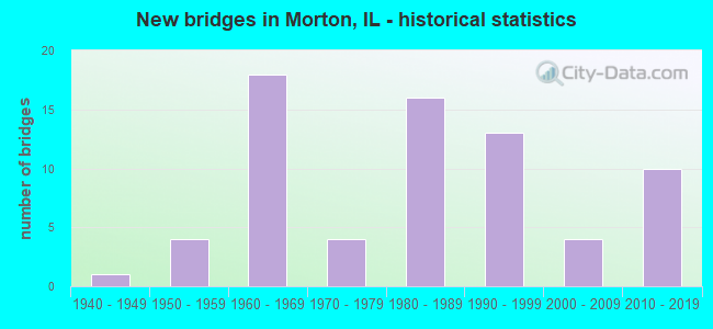
- New bridges - historical statistics
- 11940-1949
- 41950-1959
- 181960-1969
- 41970-1979
- 161980-1989
- 131990-1999
- 42000-2009
- 102010-2019
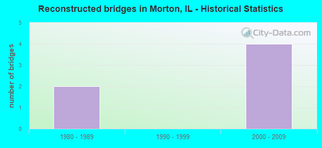
- Reconstructed bridges - Historical Statistics
- 21980-1989
- 01990-1999
- 42000-2009
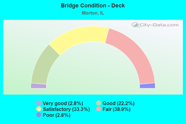
- Bridge Condition - Deck
- 2.8%Very good
- 22.2%Good
- 33.3%Satisfactory
- 38.9%Fair
- 2.8%Poor
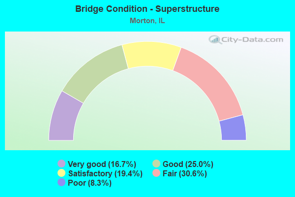
- Bridge Condition - Superstructure
- 16.7%Very good
- 25.0%Good
- 19.4%Satisfactory
- 30.6%Fair
- 8.3%Poor
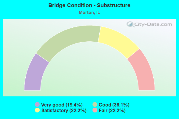
- Bridge Condition - Substructure
- 19.4%Very good
- 36.1%Good
- 22.2%Satisfactory
- 22.2%Fair
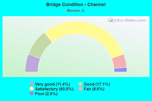
- Bridge Condition - Channel
- 11.4%Very good
- 17.1%Good
- 60.0%Satisfactory
- 8.6%Fair
- 2.9%Poor
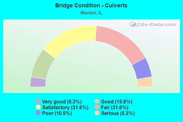
- Bridge Condition - Culverts
- 5.3%Very good
- 15.8%Good
- 31.6%Satisfactory
- 31.6%Fair
- 10.5%Poor
- 5.3%Serious
Find on map >> Show street view
Structure Number: 905035, Location: CTR-25-T25NR4W (Lat: 40.590111, Lng: -89.502772), Route carried "on" structure: County highway , Year Built: 1947, Status: Open, Structure Length: 0.70m (2.30ft), Average Daily Traffic: 1,450 (year 2018), Truck Traffic: 2%, Average Future Daily Traffic: 1,720 (year 2032), Features Intersected: DILLON CREEK, Facility Carried by Structure: TR 61
Minimum Vertical Clearance: 30+ m (98+ ft), Kilometerpoint: 2.720, Lanes on structure: 2, Owner: Town or Township Highway Agency, Approaching Roadway Width: 6.6m (21.7ft), Material/Design: Concrete, Design/Construction: Culvert, Number Of Spans In Main Unit: 2, Length of Maximum Span: 3.0m (9.8ft)
Condition: Channel: Fair, Culverts: Good, Operating Rating: 40.5 metric tons, Method Used To Determine Operating Rating: Field evaluation and documented engineering judgment, Inventory Rating: 24.3 metric tons, Method Used To Determine Inventory Rating: Field evaluation and documented engineering judgment, Structural Evaluation: Equal to present minimum criteria, Waterway Adequacy: Better than present minimum criteria, Approach Roadway Alignment: Equal to present desirable criteria, Designated Inspection Frequency: Every 24 months, Inspection Date: January 2021, Wearing Surface/Protective System: Wearing Surface: Bituminous
Find on map >> Show street view
Structure Number: 905036, Location: CTR-27-T25NR3W (Lat: 40.591669, Lng: -89.427853), Route carried "on" structure: County highway , Year Built: 1958, Status: Open, Structure Length: 0.70m (2.30ft), Average Daily Traffic: 950 (year 2018), Truck Traffic: 4%, Average Future Daily Traffic: 1,129 (year 2032), Features Intersected: STREAM, Facility Carried by Structure: TR 61B
Minimum Vertical Clearance: 30+ m (98+ ft), Kilometerpoint: 2.269, Lanes on structure: 2, Owner: Town or Township Highway Agency, Approaching Roadway Width: 7.9m (25.9ft), Material/Design: Concrete, Design/Construction: Culvert, Number Of Spans In Main Unit: 2, Length of Maximum Span: 3.0m (9.8ft)
Condition: Channel: Good, Culverts: Satisfactory, Operating Rating: 40.5 metric tons, Method Used To Determine Operating Rating: Field evaluation and documented engineering judgment, Inventory Rating: 24.3 metric tons, Method Used To Determine Inventory Rating: Field evaluation and documented engineering judgment, Structural Evaluation: Equal to present minimum criteria, Waterway Adequacy: Better than present minimum criteria, Approach Roadway Alignment: Equal to present desirable criteria, Designated Inspection Frequency: Every 24 months, Inspection Date: January 2022, Wearing Surface/Protective System: Wearing Surface: Bituminous
Find on map >> Show street view
Structure Number: 905037, Location: NW-35-T25NR3W (Lat: 40.584606, Lng: -89.419031), Route carried "on" structure: County highway , Year Built: 1957, Status: Open, Structure Length: 0.70m (2.30ft), Average Daily Traffic: 50 (year 2018), Truck Traffic: 4%, Average Future Daily Traffic: 81 (year 2032), Features Intersected: STREAM, Facility Carried by Structure: TR 65
Minimum Vertical Clearance: 30+ m (98+ ft), Kilometerpoint: 1.030, Lanes on structure: 2, Owner: Town or Township Highway Agency, Approaching Roadway Width: 7.0m (23.0ft), Material/Design: Concrete, Design/Construction: Culvert, Number Of Spans In Main Unit: 2, Length of Maximum Span: 3.0m (9.8ft)
Condition: Channel: Satisfactory, Culverts: Fair, Operating Rating: 36.6 metric tons, Method Used To Determine Operating Rating: Allowable Stress (AS) rating reported by rating factor (RF) method using MS18 loading, Inventory Rating: 22.0 metric tons, Method Used To Determine Inventory Rating: Allowable Stress (AS) rating reported by rating factor (RF) method using MS18 loading, Structural Evaluation: Somewhat better than minimum adequacy, Waterway Adequacy: Superior to present desirable criteria, Approach Roadway Alignment: Equal to present desirable criteria, Designated Inspection Frequency: Every 24 months, Inspection Date: January 2021, Wearing Surface/Protective System: Wearing Surface: Bituminous
Find on map >> Show street view
Structure Number: 905053, Location: NE COR-1-T25NR4W (Lat: 40.568233, Lng: -89.495306), Route carried "on" structure: County highway , Year Built: 1978, Status: Open, Structure Length: 1.10m (3.61ft), Average Daily Traffic: 4,800 (year 2018), Truck Traffic: 6%, Average Future Daily Traffic: 4,569 (year 2032), Design Load: HS 20, Features Intersected: DILLON CREEK, Facility Carried by Structure: FAS 1467 - CH 19
Minimum Vertical Clearance: 30+ m (98+ ft), Kilometerpoint: 7.145, Lanes on structure: 2, Base Highway Network: Yes, Owner: County Highway Agency, Approaching Roadway Width: 11.5m (37.7ft), Material/Design: Concrete, Design/Construction: Culvert, Number Of Spans In Main Unit: 3, Length of Maximum Span: 4.0m (13.1ft)
Condition: Channel: Satisfactory, Culverts: Good, Operating Rating: 44.4 metric tons, Method Used To Determine Operating Rating: Assigned rating based on Load Factor Design (LFD) reported by rating factor (RF) using MS18 loading, Inventory Rating: 32.4 metric tons, Method Used To Determine Inventory Rating: Assigned rating based on Load Factor Design (LFD) reported by rating factor (RF) using MS18 loading, Structural Evaluation: Better than present minimum criteria, Waterway Adequacy: Superior to present desirable criteria, Approach Roadway Alignment: Equal to present desirable criteria, Designated Inspection Frequency: Every 48 months, Inspection Date: January 2019, Wearing Surface/Protective System: Wearing Surface: Bituminous
Find on map >> Show street view
Structure Number: 905057, Location: NW COR-2-T24NR3W (Lat: 40.570128, Lng: -89.419903), Route carried "on" structure: County highway , Year Built: 1980, Status: Open, Structure Length: 1.19m (3.90ft), Average Daily Traffic: 1,500 (year 2018), Truck Traffic: 9%, Average Future Daily Traffic: 1,021 (year 2032), Design Load: HS 20, Features Intersected: DEER CREEK, Facility Carried by Structure: TR 71A
Minimum Vertical Clearance: 30+ m (98+ ft), Kilometerpoint: 2.945, Lanes on structure: 2, Owner: Town or Township Highway Agency, Approaching Roadway Width: 9.1m (29.9ft), Material/Design: Concrete, Design/Construction: Culvert, Number Of Spans In Main Unit: 3, Length of Maximum Span: 3.7m (12.1ft)
Condition: Channel: Satisfactory, Culverts: Good, Operating Rating: 44.4 metric tons, Method Used To Determine Operating Rating: Assigned rating based on Load Factor Design (LFD) reported by rating factor (RF) using MS18 loading, Inventory Rating: 32.4 metric tons, Method Used To Determine Inventory Rating: Assigned rating based on Load Factor Design (LFD) reported by rating factor (RF) using MS18 loading, Structural Evaluation: Better than present minimum criteria, Waterway Adequacy: Superior to present desirable criteria, Approach Roadway Alignment: Equal to present desirable criteria, Designated Inspection Frequency: Every 48 months, Inspection Date: January 2020
Find on map >> Show street view
Structure Number: 906075, Location: E CTR-28-T25NR3W (Lat: 40.597550, Lng: -89.465853), Route carried "on" structure: Other road , Year Built: 1982, Status: Open, Structure Length: 0.97m (3.18ft), Average Daily Traffic: 2,350 (year 2018), Truck Traffic: 3%, Average Future Daily Traffic: 2,043 (year 2032), Design Load: HS 20+Mod, Features Intersected: PRAIRIE CREEK, Facility Carried by Structure: IDLEWOOD ST
Minimum Vertical Clearance: 30+ m (98+ ft), Kilometerpoint: 0.595, Lanes on structure: 2, Owner: City or Municipal Highway Agency, Approaching Roadway Width: 11.6m (38.1ft), Skew: 4 degrees, Material/Design: Concrete, Design/Construction: Culvert, Number Of Spans In Main Unit: 2, Length of Maximum Span: 4.3m (14.1ft), Curb or Sidewalk Widths: Left: 1.5m (4.9ft), Right: 1.5m (4.9ft)
Condition: Channel: Very good, Culverts: Fair, Operating Rating: 44.4 metric tons, Method Used To Determine Operating Rating: Assigned rating based on Load Factor Design (LFD) reported by rating factor (RF) using MS18 loading, Inventory Rating: 32.4 metric tons, Method Used To Determine Inventory Rating: Assigned rating based on Load Factor Design (LFD) reported by rating factor (RF) using MS18 loading, Structural Evaluation: Somewhat better than minimum adequacy, Waterway Adequacy: Better than present minimum criteria, Approach Roadway Alignment: Better than present minimum criteria, Designated Inspection Frequency: Every 24 months, Inspection Date: November 2021
Find on map >> Show street view
Structure Number: 906076, Location: EAST OF LEE ST (Lat: 40.599369, Lng: -89.464892), Route carried "on" structure: City street , Year Built: 1982, Status: Open, Structure Length: 0.85m (2.79ft), Average Daily Traffic: 650 (year 2018), Truck Traffic: 9%, Average Future Daily Traffic: 645 (year 2032), Design Load: HS 20, Features Intersected: Prairie Creek, Facility Carried by Structure: MS-1690 GreenwoodS
Minimum Vertical Clearance: 30+ m (98+ ft), Kilometerpoint: 0.644, Lanes on structure: 2, Owner: City or Municipal Highway Agency, Approaching Roadway Width: 10.7m (35.1ft), Skew: 3 degrees, Material/Design: Prestressed concrete, Design/Construction: Box Beam or Girders - Multiple, Number Of Spans In Main Unit: 1, Length of Maximum Span: 7.9m (25.9ft), Curb-To-Curb Width: 13.4m (44.0ft), Out-to-Out Width: 13.5m (44.3ft)
Condition: Deck: Good, Superstructure: Good, Substructure: Very good, Channel: Very good, Operating Rating: 44.4 metric tons, Method Used To Determine Operating Rating: Assigned rating based on Load Factor Design (LFD) reported by rating factor (RF) using MS18 loading, Inventory Rating: 32.4 metric tons, Method Used To Determine Inventory Rating: Assigned rating based on Load Factor Design (LFD) reported by rating factor (RF) using MS18 loading, Structural Evaluation: Better than present minimum criteria, Deck Geometry: Superior to present desirable criteria, Waterway Adequacy: Equal to present desirable criteria, Approach Roadway Alignment: Equal to present desirable criteria, Designated Inspection Frequency: Every 48 months, Inspection Date: November 2021, Deck Structure Type: Concrete Precast Panels, Wearing Surface/Protective System: Wearing Surface: Bituminous, Membrane: Built-up
Find on map >> Show street view
Structure Number: 906077, Location: EAST OF LEE ST (Lat: 40.601231, Lng: -89.464200), Route carried "on" structure: City street , Year Built: 1983, Status: Open, Structure Length: 0.82m (2.69ft), Average Daily Traffic: 400 (year 2018), Truck Traffic: 8%, Average Future Daily Traffic: 296 (year 2032), Design Load: HS 20, Features Intersected: PRAIRIE CREEK, Facility Carried by Structure: FERNWOOD STREET
Minimum Vertical Clearance: 30+ m (98+ ft), Kilometerpoint: 0.418, Lanes on structure: 2, Owner: City or Municipal Highway Agency, Approaching Roadway Width: 10.4m (34.1ft), Skew: 3 degrees, Material/Design: Prestressed concrete, Design/Construction: Box Beam or Girders - Multiple, Number Of Spans In Main Unit: 1, Length of Maximum Span: 7.3m (24.0ft), Curb or Sidewalk Widths: Left: 1.5m (4.9ft), Right: 1.5m (4.9ft), Curb-To-Curb Width: 10.4m (34.1ft), Out-to-Out Width: 15.9m (52.2ft)
Condition: Deck: Good, Superstructure: Good, Substructure: Very good, Channel: Very good, Operating Rating: 44.4 metric tons, Method Used To Determine Operating Rating: Assigned rating based on Load Factor Design (LFD) reported by rating factor (RF) using MS18 loading, Inventory Rating: 32.4 metric tons, Method Used To Determine Inventory Rating: Assigned rating based on Load Factor Design (LFD) reported by rating factor (RF) using MS18 loading, Structural Evaluation: Better than present minimum criteria, Deck Geometry: Better than present minimum criteria, Waterway Adequacy: Superior to present desirable criteria, Approach Roadway Alignment: Better than present minimum criteria, Designated Inspection Frequency: Every 48 months, Inspection Date: November 2021, Deck Structure Type: Concrete Precast Panels, Wearing Surface/Protective System: Wearing Surface: Bituminous, Membrane: Built-up
Find on map >> Show street view
Structure Number: 906078, Location: EAST OF LEE AVE (Lat: 40.602297, Lng: -89.463772), Route carried "on" structure: City street , Year Built: 1984, Status: Open, Structure Length: 0.76m (2.49ft), Average Daily Traffic: 275 (year 2018), Truck Traffic: 11%, Average Future Daily Traffic: 323 (year 2032), Design Load: HS 20, Features Intersected: PRAIRIE CREEK, Facility Carried by Structure: EDGEWOOD ST
Minimum Vertical Clearance: 30+ m (98+ ft), Kilometerpoint: 0.016, Lanes on structure: 2, Owner: City or Municipal Highway Agency, Approaching Roadway Width: 10.4m (34.1ft), Skew: 2 degrees, Material/Design: Prestressed concrete, Design/Construction: Box Beam or Girders - Multiple, Number Of Spans In Main Unit: 1, Length of Maximum Span: 7.3m (24.0ft), Curb-To-Curb Width: 13.4m (44.0ft), Out-to-Out Width: 13.4m (44.0ft)
Condition: Deck: Good, Superstructure: Good, Substructure: Good, Channel: Very good, Operating Rating: 44.4 metric tons, Method Used To Determine Operating Rating: Assigned rating based on Load Factor Design (LFD) reported by rating factor (RF) using MS18 loading, Inventory Rating: 32.4 metric tons, Method Used To Determine Inventory Rating: Assigned rating based on Load Factor Design (LFD) reported by rating factor (RF) using MS18 loading, Structural Evaluation: Better than present minimum criteria, Deck Geometry: Superior to present desirable criteria, Waterway Adequacy: Superior to present desirable criteria, Approach Roadway Alignment: Better than present minimum criteria, Designated Inspection Frequency: Every 48 months, Inspection Date: November 2021, Deck Structure Type: Concrete Precast Panels, Wearing Surface/Protective System: Wearing Surface: Bituminous, Membrane: Built-up
Find on map >> Show street view
Structure Number: 90608, Location: SE 16 T25NR3W (Lat: 40.616378, Lng: -89.445633), Route carried "on" structure: City street , Year Built: 1985, Status: Open, Structure Length: 0.85m (2.79ft), Average Daily Traffic: 1,150 (year 2018), Truck Traffic: 4%, Average Future Daily Traffic: 1,236 (year 2032), Features Intersected: BULL RUN CREEK, Facility Carried by Structure: POLK ST
Minimum Vertical Clearance: 30+ m (98+ ft), Kilometerpoint: 0.789, Lanes on structure: 2, Owner: City or Municipal Highway Agency, Approaching Roadway Width: 10.1m (33.1ft), Material/Design: Concrete, Design/Construction: Culvert, Number Of Spans In Main Unit: 2, Length of Maximum Span: 3.7m (12.1ft), Curb or Sidewalk Widths: Left: 1.7m (5.6ft), Right: 1.7m (5.6ft), Curb-To-Curb Width: 10.2m (33.5ft), Out-to-Out Width: 13.6m (44.6ft)
Condition: Channel: Satisfactory, Culverts: Fair, Operating Rating: 40.5 metric tons, Method Used To Determine Operating Rating: Field evaluation and documented engineering judgment, Inventory Rating: 24.3 metric tons, Method Used To Determine Inventory Rating: Field evaluation and documented engineering judgment, Structural Evaluation: Somewhat better than minimum adequacy, Deck Geometry: Somewhat better than minimum adequacy, Waterway Adequacy: Better than present minimum criteria, Approach Roadway Alignment: Equal to present desirable criteria, Designated Inspection Frequency: Every 24 months, Inspection Date: November 2021
Find on map >> Show street view
Structure Number: 906081, Location: 0.17 MI W OF I-155 (Lat: 40.590631, Lng: -89.481383), Route carried "on" structure: City street , Year Built: 1991, Status: Open, Structure Length: 0.66m (2.17ft), Average Daily Traffic: 1,450 (year 2018), Truck Traffic: 2%, Average Future Daily Traffic: 1,720 (year 2032), Design Load: HS 20, Features Intersected: DILLON CREEK TRIB, Facility Carried by Structure: QUEENWOOD RD-MORTO
Minimum Vertical Clearance: 30+ m (98+ ft), Kilometerpoint: 1.030, Lanes on structure: 2, Owner: City or Municipal Highway Agency, Approaching Roadway Width: 12.2m (40.0ft), Skew: 1 degrees, Material/Design: Concrete continuous, Design/Construction: Culvert, Number Of Spans In Main Unit: 2, Length of Maximum Span: 3.2m (10.5ft)
Condition: Channel: Good, Culverts: Fair, Operating Rating: 53.8 metric tons, Method Used To Determine Operating Rating: Assigned rating based on Load Factor Design (LFD) reported by rating factor (RF) using MS18 loading, Inventory Rating: 32.4 metric tons, Method Used To Determine Inventory Rating: Assigned rating based on Load Factor Design (LFD) reported by rating factor (RF) using MS18 loading, Structural Evaluation: Somewhat better than minimum adequacy, Waterway Adequacy: Superior to present desirable criteria, Approach Roadway Alignment: Equal to present desirable criteria, Designated Inspection Frequency: Every 24 months, Inspection Date: November 2021
Find on map >> Show street view
Structure Number: 906082, Location: SW 1/4 4T25N R3W (Lat: 40.645589, Lng: -89.453294), Route carried "on" structure: City street , Year Built: 1974, Status: Open, Structure Length: 1.12m (3.67ft), Average Daily Traffic: 1,700 (year 2018), Truck Traffic: 3%, Average Future Daily Traffic: 1,881 (year 2032), Features Intersected: TRIB ACKERMAN CR, Facility Carried by Structure: MS #6400B MAIN EXT
Minimum Vertical Clearance: 30+ m (98+ ft), Kilometerpoint: 0.290, Lanes on structure: 2, Owner: City or Municipal Highway Agency, Approaching Roadway Width: 6.0m (19.7ft), Skew: 3 degrees, Material/Design: Concrete continuous, Design/Construction: Culvert, Number Of Spans In Main Unit: 2, Length of Maximum Span: 5.6m (18.4ft)
Condition: Channel: Fair, Culverts: Satisfactory, Operating Rating: 53.8 metric tons, Method Used To Determine Operating Rating: Field evaluation and documented engineering judgment, Inventory Rating: 32.4 metric tons, Method Used To Determine Inventory Rating: Field evaluation and documented engineering judgment, Structural Evaluation: Equal to present minimum criteria, Waterway Adequacy: Better than present minimum criteria, Approach Roadway Alignment: Equal to present minimum criteria, Length Of Structure Improvement: 1.80m (5.91ft), Designated Inspection Frequency: Every 24 months, Inspection Date: November 2021, Bridge Improvement Cost: $76,000, Roadway Improvement Cost: $8,000, Total Project Cost: $114,000
Find on map >> Show street view
Structure Number: 906083, Location: NE1/4 21 T25N R3W (Lat: 40.609414, Lng: -89.443106), Route carried "on" structure: City street , Year Built: 1984, Status: Open, Structure Length: 0.85m (2.79ft), Average Daily Traffic: 525 (year 2018), Truck Traffic: 6%, Average Future Daily Traffic: 376 (year 2032), Features Intersected: BULL RUN CREEK, Facility Carried by Structure: E. MONROE ST
Minimum Vertical Clearance: 30+ m (98+ ft), Kilometerpoint: 0.837, Lanes on structure: 2, Owner: City or Municipal Highway Agency, Approaching Roadway Width: 10.5m (34.4ft), Skew: 3 degrees, Material/Design: Concrete continuous, Design/Construction: Culvert, Number Of Spans In Main Unit: 2, Length of Maximum Span: 4.6m (15.1ft), Curb or Sidewalk Widths: Left: 1.5m (4.9ft), Right: 1.5m (4.9ft)
Condition: Channel: Satisfactory, Culverts: Satisfactory, Operating Rating: 53.8 metric tons, Method Used To Determine Operating Rating: Field evaluation and documented engineering judgment, Inventory Rating: 32.4 metric tons, Method Used To Determine Inventory Rating: Field evaluation and documented engineering judgment, Structural Evaluation: Equal to present minimum criteria, Waterway Adequacy: Better than present minimum criteria, Approach Roadway Alignment: Equal to present desirable criteria, Designated Inspection Frequency: Every 24 months, Inspection Date: November 2021
Find on map >> Show street view
Structure Number: 906084, Location: WEST LINE 22 T25NR3W (Lat: 40.605964, Lng: -89.440444), Route carried "on" structure: Other road , Year Built: 1974, Status: Open, Structure Length: 1.37m (4.49ft), Average Daily Traffic: 2,550 (year 2018), Truck Traffic: 3%, Average Future Daily Traffic: 1,398 (year 2032), Features Intersected: BULL RUN CREEK, Facility Carried by Structure: E. JEFFERSON ST
Minimum Vertical Clearance: 30+ m (98+ ft), Kilometerpoint: 11.812, Lanes on structure: 2, Owner: City or Municipal Highway Agency, Approaching Roadway Width: 6.7m (22.0ft), Skew: 3 degrees, Material/Design: Concrete continuous, Design/Construction: Culvert, Number Of Spans In Main Unit: 3, Length of Maximum Span: 5.0m (16.4ft), Curb or Sidewalk Widths: Left: 1.5m (4.9ft), Right: 1.5m (4.9ft), Curb-To-Curb Width: 13.4m (44.0ft), Out-to-Out Width: 16.8m (55.1ft)
Condition: Channel: Good, Culverts: Poor, Operating Rating: 32.4 metric tons, Method Used To Determine Operating Rating: Field evaluation and documented engineering judgment, Inventory Rating: 19.4 metric tons, Method Used To Determine Inventory Rating: Field evaluation and documented engineering judgment, Structural Evaluation: Meets minimum limits, Deck Geometry: Better than present minimum criteria, Waterway Adequacy: Better than present minimum criteria, Approach Roadway Alignment: Equal to present desirable criteria, Designated Inspection Frequency: Every 24 months, Inspection Date: November 2021
Find on map >> Show street view
Structure Number: 906085, Location: SE 1/4-32-T25NR3W (Lat: 40.569042, Lng: -89.462469), Route carried "on" structure: Other road , Year Built: 1995, Status: Open, Structure Length: 1.95m (6.40ft), Average Daily Traffic: 2,950 (year 2018), Truck Traffic: 9%, Average Future Daily Traffic: 1,290 (year 2032), Design Load: HS 20, Features Intersected: PRAIRIE CREEK, Facility Carried by Structure: BROADWAY RD
Minimum Vertical Clearance: 30+ m (98+ ft), Kilometerpoint: 0.531, Lanes on structure: 2, Owner: City or Municipal Highway Agency, Approaching Roadway Width: 9.1m (29.9ft), Material/Design: Prestressed concrete, Design/Construction: Stringer/Multi-beam, Number Of Spans In Main Unit: 1, Length of Maximum Span: 18.7m (61.4ft), Curb-To-Curb Width: 9.1m (29.9ft), Out-to-Out Width: 9.1m (29.9ft)
Condition: Deck: Satisfactory, Superstructure: Very good, Substructure: Good, Channel: Good, Operating Rating: 44.1 metric tons, Method Used To Determine Operating Rating: Assigned rating based on Load Factor Design (LFD) reported by rating factor (RF) using MS18 loading, Inventory Rating: 32.4 metric tons, Method Used To Determine Inventory Rating: Assigned rating based on Load Factor Design (LFD) reported by rating factor (RF) using MS18 loading, Structural Evaluation: Better than present minimum criteria, Deck Geometry: Meets minimum limits, Waterway Adequacy: Superior to present desirable criteria, Approach Roadway Alignment: Equal to present desirable criteria, Designated Inspection Frequency: Every 48 months, Inspection Date: November 2021, Deck Structure Type: Concrete Cast-file-Place, Wearing Surface/Protective System: Deck Protection: Epoxy Coated Reinforcing
Find on map >> Show street view
Structure Number: 900019, Location: N MAIN ST IN MORTON (Lat: 40.620711, Lng: -89.450767), Route carried "under" structure: Other road , Year Built: 1960, Structure Length: 0. m, Average Daily Traffic: 7,250 (year 2018), Truck Traffic: 3%, Features Intersected: N MAIN STREET, Facility Carried by Structure: EB I-74
Minimum Vertical Clearance: 4.32m (14.17ft), Kilometerpoint: 2.720, Lanes on structure: 2, Lanes under structure: 2, Material/Design: Steel continuous, Design/Construction: Stringer/Multi-beam, Length of Maximum Span: 14.4m (47.2ft)
Find on map >> Show street view
Structure Number: 90002, Location: N MAIN ST IN MORTON (Lat: 40.621125, Lng: -89.450533), Route carried "under" structure: Other road , Year Built: 1960, Structure Length: 0. m, Average Daily Traffic: 7,250 (year 2018), Truck Traffic: 3%, Features Intersected: N MAIN STREET, Facility Carried by Structure: WB I-74
Minimum Vertical Clearance: 4.32m (14.17ft), Kilometerpoint: 2.671, Lanes on structure: 2, Lanes under structure: 2, Material/Design: Steel continuous, Design/Construction: Stringer/Multi-beam, Length of Maximum Span: 14.4m (47.2ft)
Find on map >> Show street view
Structure Number: 900075, Location: 1.5 MI E OF MORTON (Lat: 40.621833, Lng: -89.403369), Route carried "under" structure: Interstate 74, Year Built: 1960, Structure Length: 0. m, Average Daily Traffic: 23,700 (year 2021), Truck Traffic: 22%, Features Intersected: I-74, Facility Carried by Structure: FAS 2467 - CH 3
Minimum Vertical Clearance: 4.95m (16.24ft), Kilometerpoint: 172.453, Lanes on structure: 2, Lanes under structure: 4, Material/Design: Steel continuous, Design/Construction: Stringer/Multi-beam, Length of Maximum Span: 20.4m (66.9ft)
Find on map >> Show street view
Structure Number: 900084, Location: EAST EDGE OF MORTON (Lat: 40.620883, Lng: -89.431528), Route carried "under" structure: Interstate 74, Year Built: 1960, Structure Length: 0. m, Average Daily Traffic: 23,700 (year 2021), Truck Traffic: 22%, Features Intersected: I-74, Facility Carried by Structure: TENNESSEE RD-TR234
Minimum Vertical Clearance: 5.00m (16.40ft), Kilometerpoint: 170.071, Lanes on structure: 2, Lanes under structure: 4, Material/Design: Steel continuous, Design/Construction: Stringer/Multi-beam, Length of Maximum Span: 20.4m (66.9ft)
Find on map >> Show street view
Structure Number: 900128, Location: 1.2 MI S OF I-74 (Lat: 40.604950, Lng: -89.478531), Route carried "under" structure: State highway 98, Year Built: 1989, Structure Length: 0. m, Average Daily Traffic: 6,850 (year 2021), Truck Traffic: 13%, Features Intersected: IL 98, Facility Carried by Structure: SB I-155
Minimum Vertical Clearance: 5.03m (16.50ft), Kilometerpoint: 13.438, Lanes on structure: 2, Lanes under structure: 4, Material/Design: Steel continuous, Design/Construction: Stringer/Multi-beam, Length of Maximum Span: 22.4m (73.5ft)
Find on map >> Show street view
Structure Number: 900129, Location: 1.2 MI S OF I-74 (Lat: 40.604956, Lng: -89.478142), Route carried "under" structure: Other road , Year Built: 1988, Structure Length: 0. m, Average Daily Traffic: 8,250 (year 2018), Truck Traffic: 8%, Features Intersected: IL 98, Facility Carried by Structure: NB I-155
Minimum Vertical Clearance: 5.21m (17.09ft), Kilometerpoint: 3.315, Lanes on structure: 2, Lanes under structure: 4, Material/Design: Steel continuous, Design/Construction: Stringer/Multi-beam, Length of Maximum Span: 22.4m (73.5ft)
Find on map >> Show street view
Structure Number: 90013, Location: 1 MI S OF ILL 98 (Lat: 40.590622, Lng: -89.477944), Route carried "under" structure: Interstate 155, Year Built: 1992, Structure Length: 0. m, Average Daily Traffic: 19,100 (year 2021), Truck Traffic: 15%, Features Intersected: I-155, Facility Carried by Structure: QUEENWOOD RD
Minimum Vertical Clearance: 4.95m (16.24ft), Kilometerpoint: 48.247, Lanes on structure: 2, Lanes under structure: 4, Material/Design: Steel continuous, Design/Construction: Stringer/Multi-beam, Length of Maximum Span: 28.9m (94.8ft)
Find on map >> Show street view
Structure Number: 900131, Location: 1.6 MI S OF IL 98 (Lat: 40.581981, Lng: -89.477814), Route carried "under" structure: Interstate 155, Year Built: 1990, Structure Length: 0. m, Average Daily Traffic: 16,400 (year 2021), Truck Traffic: 15%, Features Intersected: I-155, Facility Carried by Structure: SB MAIN ST
Minimum Vertical Clearance: 4.95m (16.24ft), Kilometerpoint: 47.249, Lanes on structure: 1, Lanes under structure: 4, Material/Design: Steel continuous, Design/Construction: Box Beam or Girders - Single/Spread, Length of Maximum Span: 67.0m (219.8ft)
Find on map >> Show street view
Structure Number: 900132, Location: 2.5 MI S OF IL 98 (Lat: 40.568639, Lng: -89.477561), Route carried "under" structure: Interstate 155, Year Built: 1990, Structure Length: 0. m, Average Daily Traffic: 20,400 (year 2021), Truck Traffic: 14%, Features Intersected: I-155, Facility Carried by Structure: BROADWAY
Minimum Vertical Clearance: 4.95m (16.24ft), Kilometerpoint: 45.801, Lanes on structure: 2, Lanes under structure: 4, Material/Design: Steel continuous, Design/Construction: Stringer/Multi-beam, Length of Maximum Span: 29.4m (96.5ft)
Find on map >> Show street view
Structure Number: 900133, Location: 2 MI N OF ILL 9 (Lat: 40.554156, Lng: -89.477331), Route carried "under" structure: Interstate 155, Year Built: 1992, Structure Length: 0. m, Average Daily Traffic: 16,900 (year 2021), Truck Traffic: 17%, Features Intersected: I-155, Facility Carried by Structure: ALLENTOWN RD
Minimum Vertical Clearance: 4.95m (16.24ft), Kilometerpoint: 44.191, Lanes on structure: 3, Lanes under structure: 4, Material/Design: Steel continuous, Design/Construction: Stringer/Multi-beam, Length of Maximum Span: 27.8m (91.2ft)
Find on map >> Show street view
Structure Number: 900141, Location: MORTON INTERCHANGE (Lat: 40.621803, Lng: -89.464289), Route carried "under" structure: Interstate 74, Year Built: 1994, Structure Length: 0. m, Average Daily Traffic: 23,700 (year 2021), Truck Traffic: 22%, Features Intersected: I-74, Facility Carried by Structure: MORTONAVE-FAU6729
Minimum Vertical Clearance: 5.05m (16.57ft), Kilometerpoint: 167.287, Lanes on structure: 4, Lanes under structure: 4, Material/Design: Steel continuous, Design/Construction: Stringer/Multi-beam, Length of Maximum Span: 33.2m (108.9ft)
Find on map >> Show street view
Structure Number: 900165, Location: I-155/74INTERCHANGE (Lat: 40.620756, Lng: -89.485217), Route carried "under" structure: Interstate 74, Year Built: 2015, Structure Length: 0. m, Average Daily Traffic: 49,400 (year 2021), Truck Traffic: 14%, Features Intersected: I-74, Facility Carried by Structure: I-155 SB
Minimum Vertical Clearance: 5.46m (17.91ft), Kilometerpoint: 165.484, Lanes on structure: 1, Lanes under structure: 6, Material/Design: Steel continuous, Design/Construction: Stringer/Multi-beam, Length of Maximum Span: 36.9m (121.1ft)
Find on map >> Show street view
Structure Number: 900166, Location: I-155/74INTERCHANGE (Lat: 40.620717, Lng: -89.484678), Route carried "under" structure: Interstate 74, Year Built: 2016, Structure Length: 0. m, Average Daily Traffic: 49,400 (year 2021), Truck Traffic: 14%, Features Intersected: I-74, Facility Carried by Structure: I-155NB
Minimum Vertical Clearance: 5.21m (17.09ft), Kilometerpoint: 165.533, Lanes on structure: 1, Lanes under structure: 6, Material/Design: Steel continuous, Design/Construction: Stringer/Multi-beam, Length of Maximum Span: 36.9m (121.1ft)
Find on map >> Show street view
Structure Number: 900167, Location: 0.2 Mi W. of US 150 (Lat: 40.621328, Lng: -89.477369), Route carried "under" structure: Other road , Year Built: 2015, Structure Length: 0. m, Average Daily Traffic: 4,550 (year 2018), Truck Traffic: 4%, Features Intersected: CH 22 JEFFERSON ST, Facility Carried by Structure: I-74WB&EB
Minimum Vertical Clearance: 5.31m (17.42ft), Kilometerpoint: 7.853, Lanes on structure: 4, Lanes under structure: 2, Material/Design: Steel, Design/Construction: Stringer/Multi-beam, Length of Maximum Span: 37.2m (122.0ft)
Find on map >> Show street view
Structure Number: 900169, Location: .5 MI W MORTON INTER (Lat: 40.621564, Lng: -89.473544), Route carried "under" structure: US 150, Year Built: 2015, Structure Length: 0. m, Average Daily Traffic: 6,150 (year 2021), Truck Traffic: 4%, Features Intersected: US150 & Bike Path, Facility Carried by Structure: I-74
Minimum Vertical Clearance: 5.79m (19.00ft), Kilometerpoint: 163.280, Lanes on structure: 6, Lanes under structure: 2, Material/Design: Steel continuous, Design/Construction: Stringer/Multi-beam, Length of Maximum Span: 51.8m (169.9ft)