Bridge Statistics for Moses Lake, Washington (WA)
Condition, Traffic, Stress, Structural Evaluation, Project Costs
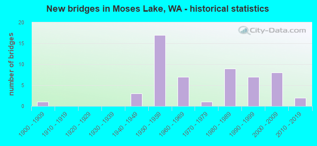
- New bridges - historical statistics
- 11900-1909
- 31940-1949
- 171950-1959
- 71960-1969
- 11970-1979
- 91980-1989
- 71990-1999
- 82000-2009
- 22010-2019
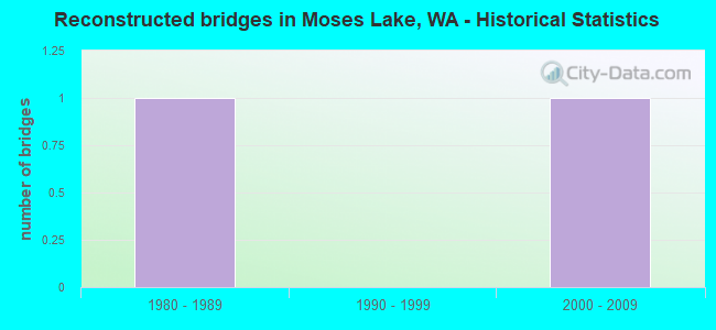
- Reconstructed bridges - Historical Statistics
- 11980-1989
- 01990-1999
- 12000-2009
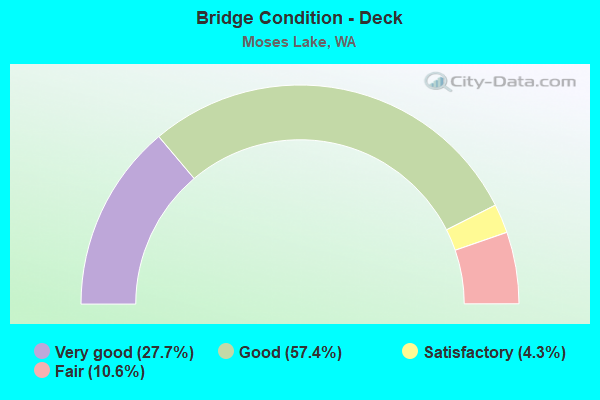
- Bridge Condition - Deck
- 27.7%Very good
- 57.4%Good
- 4.3%Satisfactory
- 10.6%Fair
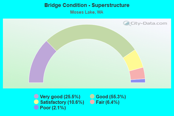
- Bridge Condition - Superstructure
- 25.5%Very good
- 55.3%Good
- 10.6%Satisfactory
- 6.4%Fair
- 2.1%Poor
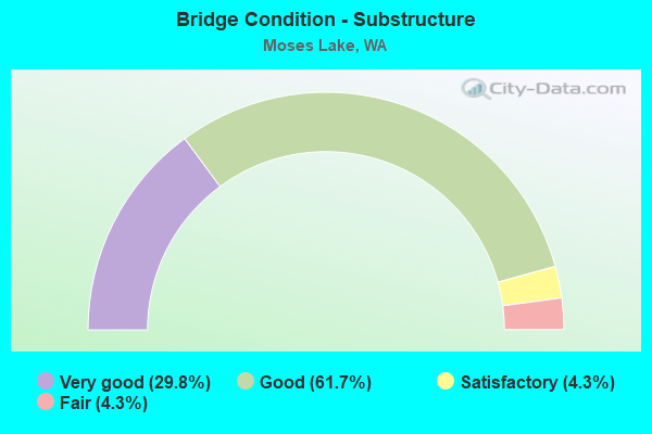
- Bridge Condition - Substructure
- 29.8%Very good
- 61.7%Good
- 4.3%Satisfactory
- 4.3%Fair
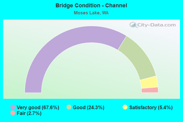
- Bridge Condition - Channel
- 67.6%Very good
- 24.3%Good
- 5.4%Satisfactory
- 2.7%Fair
Find on map >> Show street view
Structure Number: 8617, Location: M SE 0.1 S of 5.5 SE (Lat: 47.004525, Lng: -119.216058), Route carried "on" structure: County highway 92015, Year Built: 1996, Status: Open, Structure Length: 1.77m (5.81ft), Average Daily Traffic: 1,184 (year 2020), Truck Traffic: 24%, Average Future Daily Traffic: 1,700 (year 2042), Design Load: HS 20, Features Intersected: WW RCD BLK 42, Facility Carried by Structure: M Road SE
Minimum Vertical Clearance: 30+ m (98+ ft), Kilometerpoint: 0.001, Lanes on structure: 2, Owner: County Highway Agency, Approaching Roadway Width: 10.4m (34.1ft), Material/Design: Prestressed concrete, Design/Construction: Stringer/Multi-beam, Number Of Spans In Main Unit: 1, Length of Maximum Span: 17.4m (57.1ft), Curb-To-Curb Width: 10.7m (35.1ft), Out-to-Out Width: 11.0m (36.1ft)
Condition: Deck: Very good, Superstructure: Good, Substructure: Good, Channel: Very good, Operating Rating: 37.9 metric tons, Method Used To Determine Operating Rating: Load and Resistance Factor Rating (LRFR) rating reported by rating factor(RF) method using HL-93 loadings, Inventory Rating: 23.3 metric tons, Method Used To Determine Inventory Rating: Load and Resistance Factor Rating (LRFR) rating reported by rating factor(RF) method using HL-93 loadings, Structural Evaluation: Equal to present minimum criteria, Deck Geometry: Equal to present minimum criteria, Waterway Adequacy: Equal to present desirable criteria, Approach Roadway Alignment: Equal to present desirable criteria, Length Of Structure Improvement: 2.07m (6.79ft), Designated Inspection Frequency: Every 24 months, Inspection Date: January 2022, Bridge Improvement Cost: $1,034,000, Roadway Improvement Cost: $207,000, Total Project Cost: $2,067,000 ( Estimate for 2014), Deck Structure Type: Other, Wearing Surface/Protective System: Wearing Surface: Integral Concrete, Deck Protection: Epoxy Coated Reinforcing
Find on map >> Show street view
Structure Number: 86171, Location: M SE .5 South of 2 SE (Lat: 47.050386, Lng: -119.215497), Route carried "on" structure: County highway 92015, Year Built: 1996, Status: Open, Structure Length: 0.94m (3.08ft), Average Daily Traffic: 1,109 (year 2020), Truck Traffic: 22%, Average Future Daily Traffic: 2,000 (year 2042), Design Load: HS 20, Features Intersected: WW RCD BLK 42, Facility Carried by Structure: M Road SE
Minimum Vertical Clearance: 30+ m (98+ ft), Kilometerpoint: 0.001, Lanes on structure: 2, Owner: County Highway Agency, Approaching Roadway Width: 10.4m (34.1ft), Material/Design: Prestressed concrete, Design/Construction: Stringer/Multi-beam, Number Of Spans In Main Unit: 1, Length of Maximum Span: 9.1m (29.9ft), Curb-To-Curb Width: 10.7m (35.1ft), Out-to-Out Width: 11.0m (36.1ft)
Condition: Deck: Good, Superstructure: Good, Substructure: Good, Channel: Very good, Operating Rating: 41.8 metric tons, Method Used To Determine Operating Rating: Load and Resistance Factor Rating (LRFR) rating reported by rating factor(RF) method using HL-93 loadings, Inventory Rating: 26.9 metric tons, Method Used To Determine Inventory Rating: Load and Resistance Factor Rating (LRFR) rating reported by rating factor(RF) method using HL-93 loadings, Structural Evaluation: Equal to present minimum criteria, Deck Geometry: Equal to present minimum criteria, Waterway Adequacy: Equal to present desirable criteria, Approach Roadway Alignment: Equal to present desirable criteria, Length Of Structure Improvement: 1.25m (4.10ft), Designated Inspection Frequency: Every 24 months, Inspection Date: January 2022, Bridge Improvement Cost: $623,000, Roadway Improvement Cost: $125,000, Total Project Cost: $1,246,000 ( Estimate for 2014), Deck Structure Type: Other, Wearing Surface/Protective System: Wearing Surface: Integral Concrete, Deck Protection: Epoxy Coated Reinforcing
Find on map >> Show street view
Structure Number: 86249, Location: M NE 0.2 South of 10 NE (Lat: 47.230483, Lng: -119.213525), Route carried "on" structure: County highway 94030, Year Built: 1996, Status: Open, Structure Length: 3.75m (12.30ft), Average Daily Traffic: 443 (year 2019), Truck Traffic: 22%, Average Future Daily Traffic: 750 (year 2041), Design Load: HS 20+Mod, Features Intersected: EAST LOW CANAL BLK 40, Facility Carried by Structure: M NE
Minimum Vertical Clearance: 30+ m (98+ ft), Kilometerpoint: 0.001, Lanes on structure: 2, Owner: County Highway Agency, Approaching Roadway Width: 9.1m (29.9ft), Skew: 3 degrees, Material/Design: Prestressed concrete, Design/Construction: Tee Beam, Number Of Spans In Main Unit: 1, Length of Maximum Span: 36.9m (121.1ft), Curb-To-Curb Width: 8.8m (28.9ft), Out-to-Out Width: 9.1m (29.9ft)
Condition: Deck: Good, Superstructure: Very good, Substructure: Very good, Channel: Very good, Operating Rating: 39.2 metric tons, Method Used To Determine Operating Rating: Load and Resistance Factor Rating (LRFR) rating reported by rating factor(RF) method using HL-93 loadings, Inventory Rating: 24.3 metric tons, Method Used To Determine Inventory Rating: Load and Resistance Factor Rating (LRFR) rating reported by rating factor(RF) method using HL-93 loadings, Structural Evaluation: Equal to present minimum criteria, Deck Geometry: Somewhat better than minimum adequacy, Waterway Adequacy: Equal to present desirable criteria, Approach Roadway Alignment: Equal to present desirable criteria, Length Of Structure Improvement: 4.05m (13.29ft), Designated Inspection Frequency: Every 24 months, Inspection Date: November 2020, Bridge Improvement Cost: $2,022,000, Roadway Improvement Cost: $404,000, Total Project Cost: $4,043,000 ( Estimate for 2014), Deck Structure Type: Other, Wearing Surface/Protective System: Wearing Surface: Integral Concrete, Deck Protection: Epoxy Coated Reinforcing
Find on map >> Show street view
Structure Number: 86338, Location: Baseline 0.2 W of SR 17 (Lat: 47.087117, Lng: -119.238372), Route carried "on" structure: ServiceCounty highway 21700, Year Built: 1996, Status: Open, Structure Length: 1.04m (3.41ft), Average Daily Traffic: 920 (year 2020), Truck Traffic: 27%, Average Future Daily Traffic: 1,500 (year 2042), Design Load: HS 20+Mod, Features Intersected: WASTEWAY, Facility Carried by Structure: BASELINE EAST
Minimum Vertical Clearance: 30+ m (98+ ft), Kilometerpoint: 0.001, Lanes on structure: 2, Owner: County Highway Agency, Approaching Roadway Width: 10.4m (34.1ft), Material/Design: Prestressed concrete, Design/Construction: Stringer/Multi-beam, Number Of Spans In Main Unit: 1, Length of Maximum Span: 10.1m (33.1ft), Curb-To-Curb Width: 10.8m (35.4ft), Out-to-Out Width: 11.1m (36.4ft)
Condition: Deck: Very good, Superstructure: Very good, Substructure: Very good, Channel: Satisfactory, Operating Rating: 36.3 metric tons, Method Used To Determine Operating Rating: Load and Resistance Factor Rating (LRFR) rating reported by rating factor(RF) method using HL-93 loadings, Inventory Rating: 21.4 metric tons, Method Used To Determine Inventory Rating: Load and Resistance Factor Rating (LRFR) rating reported by rating factor(RF) method using HL-93 loadings, Structural Evaluation: Somewhat better than minimum adequacy, Deck Geometry: Equal to present minimum criteria, Waterway Adequacy: Equal to present desirable criteria, Approach Roadway Alignment: Equal to present desirable criteria, Length Of Structure Improvement: 1.34m (4.40ft), Designated Inspection Frequency: Every 24 months, Inspection Date: November 2020, Bridge Improvement Cost: $669,000, Roadway Improvement Cost: $134,000, Total Project Cost: $1,338,000 ( Estimate for 2014), Deck Structure Type: Concrete Precast Panels, Wearing Surface/Protective System: Wearing Surface: Integral Concrete, Deck Protection: Epoxy Coated Reinforcing
Find on map >> Show street view
Structure Number: 86339, Location: 2 SE .2 West of M SE (Lat: 47.057792, Lng: -119.228414), Route carried "on" structure: County highway 20200, Year Built: 1995, Status: Open, Structure Length: 0.85m (2.79ft), Average Daily Traffic: 49 (year 2018), Truck Traffic: 10%, Average Future Daily Traffic: 60 (year 2040), Design Load: HS 20+Mod, Features Intersected: IRRIGATION WASTEWAY, Facility Carried by Structure: 2 RD SE
Minimum Vertical Clearance: 30+ m (98+ ft), Kilometerpoint: 0.001, Lanes on structure: 2, Owner: County Highway Agency, Approaching Roadway Width: 7.3m (24.0ft), Material/Design: Prestressed concrete, Design/Construction: Stringer/Multi-beam, Number Of Spans In Main Unit: 1, Length of Maximum Span: 8.2m (26.9ft), Curb-To-Curb Width: 7.3m (24.0ft), Out-to-Out Width: 7.6m (24.9ft)
Condition: Deck: Good, Superstructure: Good, Substructure: Very good, Channel: Good, Operating Rating: 48.3 metric tons, Method Used To Determine Operating Rating: Load and Resistance Factor Rating (LRFR) rating reported by rating factor(RF) method using HL-93 loadings, Inventory Rating: 34.7 metric tons, Method Used To Determine Inventory Rating: Load and Resistance Factor Rating (LRFR) rating reported by rating factor(RF) method using HL-93 loadings, Structural Evaluation: Better than present minimum criteria, Deck Geometry: Equal to present minimum criteria, Waterway Adequacy: Equal to present desirable criteria, Approach Roadway Alignment: Equal to present desirable criteria, Length Of Structure Improvement: 1.16m (3.81ft), Designated Inspection Frequency: Every 24 months, Inspection Date: January 2022, Bridge Improvement Cost: $578,000, Roadway Improvement Cost: $116,000, Total Project Cost: $1,155,000 ( Estimate for 2014), Deck Structure Type: Other, Wearing Surface/Protective System: Wearing Surface: Integral Concrete
Find on map >> Show street view
Structure Number: 86534, Location: 1 SE 0.8 West of M SE (Lat: 47.074658, Lng: -119.230869), Route carried "on" structure: County highway 21780, Year Built: 2000, Status: Open, Structure Length: 1.04m (3.41ft), Average Daily Traffic: 292 (year 2019), Truck Traffic: 30%, Average Future Daily Traffic: 325 (year 2041), Design Load: HS 20+Mod, Features Intersected: ROCKY COULEE DRAIN, Facility Carried by Structure: 1 SE RD
Minimum Vertical Clearance: 30+ m (98+ ft), Kilometerpoint: 0.001, Lanes on structure: 2, Owner: County Highway Agency, Approaching Roadway Width: 9.1m (29.9ft), Material/Design: Prestressed concrete, Design/Construction: Tee Beam, Number Of Spans In Main Unit: 1, Length of Maximum Span: 10.1m (33.1ft), Curb-To-Curb Width: 8.6m (28.2ft), Out-to-Out Width: 8.9m (29.2ft)
Condition: Deck: Very good, Superstructure: Very good, Substructure: Very good, Channel: Very good, Operating Rating: 34.0 metric tons, Method Used To Determine Operating Rating: Load and Resistance Factor Rating (LRFR) rating reported by rating factor(RF) method using HL-93 loadings, Inventory Rating: 25.6 metric tons, Method Used To Determine Inventory Rating: Load and Resistance Factor Rating (LRFR) rating reported by rating factor(RF) method using HL-93 loadings, Structural Evaluation: Equal to present minimum criteria, Deck Geometry: Equal to present minimum criteria, Waterway Adequacy: Better than present minimum criteria, Approach Roadway Alignment: Equal to present desirable criteria, Length Of Structure Improvement: 1.04m (3.41ft), Designated Inspection Frequency: Every 24 months, Inspection Date: November 2020, Bridge Improvement Cost: $218,000, Roadway Improvement Cost: $44,000, Total Project Cost: $435,000 ( Estimate for 2014), Deck Structure Type: Other, Wearing Surface/Protective System: Wearing Surface: Integral Concrete, Deck Protection: Epoxy Coated Reinforcing
Find on map >> Show street view
Structure Number: 86536, Location: Ridgeview .02 W of L NE (Lat: 47.163069, Lng: -119.235683), Route carried "on" structure: ServiceCounty highway 44870, Year Built: 1994, Status: Open, Structure Length: 1.16m (3.81ft), Average Daily Traffic: 465 (year 2019), Truck Traffic: 12%, Average Future Daily Traffic: 565 (year 2041), Design Load: HS 20, Features Intersected: WASTEWAY, Facility Carried by Structure: RIDGEVIEW RD
Minimum Vertical Clearance: 30+ m (98+ ft), Kilometerpoint: 0.001, Lanes on structure: 2, Owner: County Highway Agency, Approaching Roadway Width: 8.5m (27.9ft), Material/Design: Prestressed concrete, Design/Construction: Stringer/Multi-beam, Number Of Spans In Main Unit: 1, Length of Maximum Span: 11.3m (37.1ft), Curb-To-Curb Width: 8.5m (27.9ft), Out-to-Out Width: 8.8m (28.9ft)
Condition: Deck: Very good, Superstructure: Very good, Substructure: Very good, Channel: Very good, Operating Rating: 31.8 metric tons, Method Used To Determine Operating Rating: Load and Resistance Factor Rating (LRFR) rating reported by rating factor(RF) method using HL-93 loadings, Inventory Rating: 20.1 metric tons, Method Used To Determine Inventory Rating: Load and Resistance Factor Rating (LRFR) rating reported by rating factor(RF) method using HL-93 loadings, Structural Evaluation: Somewhat better than minimum adequacy, Deck Geometry: Somewhat better than minimum adequacy, Waterway Adequacy: Equal to present desirable criteria, Approach Roadway Alignment: Equal to present desirable criteria, Length Of Structure Improvement: 1.46m (4.79ft), Designated Inspection Frequency: Every 24 months, Inspection Date: November 2021, Bridge Improvement Cost: $730,000, Roadway Improvement Cost: $146,000, Total Project Cost: $1,459,000 ( Estimate for 2014), Deck Structure Type: Other, Wearing Surface/Protective System: Wearing Surface: Integral Concrete, Deck Protection: Epoxy Coated Reinforcing
Find on map >> Show street view
Structure Number: 8758, Location: 4 SE 0.35 East of M SE (Lat: 47.028464, Lng: -119.208278), Route carried "on" structure: County highway 21880, Year Built: 2008, Status: Open, Structure Length: 1.07m (3.51ft), Average Daily Traffic: 106 (year 2018), Truck Traffic: 10%, Average Future Daily Traffic: 123 (year 2040), Design Load: HS 25 or greater, Features Intersected: Irrigation Drainage, Facility Carried by Structure: 4 SE
Minimum Vertical Clearance: 30+ m (98+ ft), Kilometerpoint: 0.001, Lanes on structure: 2, Owner: County Highway Agency, Approaching Roadway Width: 7.3m (24.0ft), Material/Design: Prestressed concrete, Design/Construction: Stringer/Multi-beam, Number Of Spans In Main Unit: 1, Length of Maximum Span: 10.4m (34.1ft), Curb-To-Curb Width: 8.3m (27.2ft), Out-to-Out Width: 9.2m (30.2ft)
Condition: Deck: Good, Superstructure: Very good, Substructure: Very good, Channel: Very good, Operating Rating: 62.6 metric tons, Method Used To Determine Operating Rating: Load Factor (LF), Inventory Rating: 37.2 metric tons, Method Used To Determine Inventory Rating: Load Factor (LF), Structural Evaluation: Equal to present desirable criteria, Deck Geometry: Somewhat better than minimum adequacy, Waterway Adequacy: Equal to present desirable criteria, Approach Roadway Alignment: Equal to present desirable criteria, Length Of Structure Improvement: 1.37m (4.49ft), Designated Inspection Frequency: Every 24 months, Inspection Date: January 2022, Bridge Improvement Cost: $684,000, Roadway Improvement Cost: $137,000, Total Project Cost: $1,368,000 ( Estimate for 2014), Deck Structure Type: Other, Wearing Surface/Protective System: Wearing Surface: Integral Concrete, Deck Protection: Epoxy Coated Reinforcing
Find on map >> Show street view
Structure Number: 88022, Location: 3 NE 0.1 East of O NE (Lat: 47.130519, Lng: -119.170122), Route carried "on" structure: County highway 94000, Year Built: 2010, Status: Open, Structure Length: 5.03m (16.50ft), Average Daily Traffic: 1,109 (year 2019), Truck Traffic: 28%, Average Future Daily Traffic: 1,200 (year 2041), Design Load: HL 93, Features Intersected: East Low Canal, Facility Carried by Structure: Wheeler Rd
Minimum Vertical Clearance: 30+ m (98+ ft), Kilometerpoint: 0.001, Lanes on structure: 2, Owner: County Highway Agency, Approaching Roadway Width: 10.4m (34.1ft), Skew: 2 degrees, Material/Design: Prestressed concrete, Design/Construction: Stringer/Multi-beam, Number Of Spans In Main Unit: 1, Length of Maximum Span: 49.4m (162.1ft), Curb-To-Curb Width: 10.4m (34.1ft), Out-to-Out Width: 11.0m (36.1ft)
Condition: Deck: Good, Superstructure: Good, Substructure: Very good, Channel: Very good, Operating Rating: 57.3 metric tons, Method Used To Determine Operating Rating: Load and Resistance Factor Rating (LRFR) rating reported by rating factor(RF) method using HL-93 loadings, Inventory Rating: 37.6 metric tons, Method Used To Determine Inventory Rating: Load and Resistance Factor Rating (LRFR) rating reported by rating factor(RF) method using HL-93 loadings, Structural Evaluation: Better than present minimum criteria, Deck Geometry: Equal to present minimum criteria, Waterway Adequacy: Equal to present desirable criteria, Approach Roadway Alignment: Equal to present desirable criteria, Length Of Structure Improvement: 5.33m (17.49ft), Designated Inspection Frequency: Every 24 months, Inspection Date: January 2022, Bridge Improvement Cost: $2,660,000, Roadway Improvement Cost: $532,000, Total Project Cost: $5,320,000 ( Estimate for 2014), Deck Structure Type: Other, Wearing Surface/Protective System: Wearing Surface: Integral Concrete, Deck Protection: Epoxy Coated Reinforcing
Find on map >> Show street view
Structure Number: 8872, Location: Sand Dunes .6 S of Camas (Lat: 47.083889, Lng: -119.333056), Route carried "on" structure: County highway 21590, Year Built: 2015, Status: Open, Structure Length: 1.74m (5.71ft), Average Daily Traffic: 450 (year 2018), Truck Traffic: 17%, Average Future Daily Traffic: 475 (year 2039), Design Load: HL 93, Features Intersected: Moses Lake, Facility Carried by Structure: Sand Dunes Rd
Minimum Vertical Clearance: 30+ m (98+ ft), Kilometerpoint: 0.001, Lanes on structure: 2, Owner: County Highway Agency, Approaching Roadway Width: 8.8m (28.9ft), Material/Design: Prestressed concrete, Design/Construction: Channel Beam, Number Of Spans In Main Unit: 1, Length of Maximum Span: 17.4m (57.1ft), Curb-To-Curb Width: 8.7m (28.5ft), Out-to-Out Width: 9.8m (32.2ft)
Condition: Deck: Very good, Superstructure: Good, Substructure: Very good, Channel: Very good, Operating Rating: 52.5 metric tons, Method Used To Determine Operating Rating: Load and Resistance Factor Rating (LRFR) rating reported by rating factor(RF) method using HL-93 loadings, Inventory Rating: 39.5 metric tons, Method Used To Determine Inventory Rating: Load and Resistance Factor Rating (LRFR) rating reported by rating factor(RF) method using HL-93 loadings, Structural Evaluation: Better than present minimum criteria, Deck Geometry: Somewhat better than minimum adequacy, Waterway Adequacy: Equal to present desirable criteria, Approach Roadway Alignment: Equal to present desirable criteria, Length Of Structure Improvement: 2.04m (6.69ft), Designated Inspection Frequency: Every 24 months, Inspection Date: January 2021, Bridge Improvement Cost: $1,018,000, Roadway Improvement Cost: $204,000, Total Project Cost: $2,037,000 ( Estimate for 2014), Deck Structure Type: Other, Wearing Surface/Protective System: Wearing Surface: Monolithic Concrete, Deck Protection: Epoxy Coated Reinforcing
Find on map >> Show street view
Structure Number: 5354A, Location: 1.6 E JCT SR 171 (Lat: 47.101667, Lng: -119.286694), Route carried "under" structure: Interstate 90, Year Built: 1900, Structure Length: 0. m, Average Daily Traffic: 19,250 (year 2019), Truck Traffic: 21%, Features Intersected: STATE ROUTE 90, Facility Carried by Structure: CMSTPP RR
Minimum Vertical Clearance: 5.79m (19.00ft), Kilometerpoint: 285.498, Lanes under structure: 4, Material/Design: Steel, Design/Construction: Girder and Floorbeam System, Length of Maximum Span: 10.4m (34.1ft)
Find on map >> Show street view
Structure Number: 5581A, Location: 3.6 E JCT SR 171 (Lat: 47.098667, Lng: -119.243278), Route carried "under" structure: Interstate 90, Year Built: 1958, Structure Length: 0. m, Average Daily Traffic: 19,250 (year 2019), Truck Traffic: 21%, Features Intersected: I-90, RAMP, Facility Carried by Structure: SR 17
Minimum Vertical Clearance: 5.28m (17.32ft), Kilometerpoint: 288.797, Lanes on structure: 4, Lanes under structure: 4, Material/Design: Concrete continuous, Design/Construction: Box Beam or Girders - Multiple, Length of Maximum Span: 25.0m (82.0ft)
Find on map >> Show street view
Structure Number: 5689B, Location: 22.8 E JCT SR 281 (Lat: 47.103722, Lng: -119.345083), Route carried "under" structure: Interstate 90, Year Built: 1958, Structure Length: 0. m, Average Daily Traffic: 16,936 (year 2019), Truck Traffic: 24%, Features Intersected: I-90, Facility Carried by Structure: HANSEN RD
Minimum Vertical Clearance: 5.11m (16.77ft), Kilometerpoint: 280.991, Lanes on structure: 2, Lanes under structure: 4, Material/Design: Prestressed concrete, Design/Construction: Stringer/Multi-beam, Length of Maximum Span: 15.8m (51.8ft)
Find on map >> Show street view
Structure Number: 6298A, Location: 23.6 E JCT SR 281 (Lat: 47.103694, Lng: -119.327833), Route carried "under" structure: Interstate 90, Year Built: 1960, Structure Length: 0. m, Average Daily Traffic: 18,787 (year 2019), Truck Traffic: 24%, Features Intersected: I-90, Facility Carried by Structure: PED PATH WESTLAKE
Minimum Vertical Clearance: 5.18m (16.99ft), Kilometerpoint: 282.295, Lanes under structure: 5, Material/Design: Prestressed concrete, Design/Construction: Stringer/Multi-beam, Length of Maximum Span: 32.0m (105.0ft)
Find on map >> Show street view
Structure Number: 7818A, Location: 0.9 N JCT SR 171 (Lat: 47.143167, Lng: -119.278417), Route carried "under" structure: State highway 17, Year Built: 1966, Structure Length: 0. m, Average Daily Traffic: 11,670 (year 2019), Truck Traffic: 7%, Features Intersected: SR 17, Facility Carried by Structure: STRATFORD RD
Minimum Vertical Clearance: 5.64m (18.50ft), Kilometerpoint: 88.079, Lanes on structure: 5, Lanes under structure: 4, Material/Design: Prestressed concrete continuous, Design/Construction: Stringer/Multi-beam, Length of Maximum Span: 25.0m (82.0ft)
Find on map >> Show street view
Structure Number: 15898A, Location: 24.0 E JCT SR 281 (Lat: 47.100919, Lng: -119.316472), Route carried "under" structure: Interstate 90, Year Built: 2001, Structure Length: 0. m, Average Daily Traffic: 15,046 (year 2019), Truck Traffic: 21%, Features Intersected: I-90, Facility Carried by Structure: SR 171
Minimum Vertical Clearance: 5.84m (19.16ft), Kilometerpoint: 283.228, Lanes on structure: 4, Lanes under structure: 4, Material/Design: Prestressed concrete continuous, Design/Construction: Stringer/Multi-beam, Length of Maximum Span: 33.8m (110.9ft)
Find on map >> Show street view
Structure Number: 15898B, Location: 0.6 E JCT SR 171 (Lat: 47.100717, Lng: -119.306400), Route carried "under" structure: Interstate 90, Year Built: 2001, Structure Length: 0. m, Average Daily Traffic: 15,046 (year 2019), Truck Traffic: 21%, Features Intersected: I-90, Facility Carried by Structure: PENINSULA DRIVE
Minimum Vertical Clearance: 5.44m (17.85ft), Kilometerpoint: 283.985, Lanes on structure: 2, Lanes under structure: 4, Material/Design: Prestressed concrete continuous, Design/Construction: Box Beam or Girders - Multiple, Length of Maximum Span: 29.9m (98.1ft)
Find on map >> Show street view
Structure Number: 17071A, Location: 1.9 W JCT SR 171 (Lat: 47.102483, Lng: -119.278461), Route carried "under" structure: Interstate 90, Year Built: 2006, Structure Length: 0. m, Average Daily Traffic: 19,250 (year 2019), Truck Traffic: 21%, Features Intersected: I-90, Facility Carried by Structure: POTATO HILL RD
Minimum Vertical Clearance: 5.74m (18.83ft), Kilometerpoint: 286.109, Lanes on structure: 2, Lanes under structure: 4, Material/Design: Prestressed concrete, Design/Construction: Slab, Length of Maximum Span: 20.1m (65.9ft)