Bridge Statistics for Moultrie, Georgia (GA)
Condition, Traffic, Stress, Structural Evaluation, Project Costs
- National Bridge Inventory (NBI) Statistics
- 47Number of bridges
- 499ft / 152mTotal length
- $27,402,000Total costs
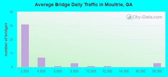
- 139,280Total average daily traffic
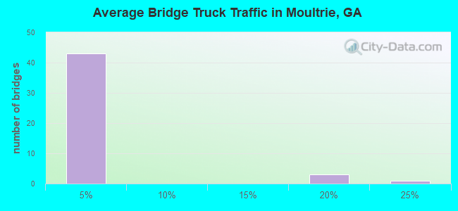
- 3,848Total average daily truck traffic
- 208,920Total future (year 2030) average daily traffic
- National Bridge Inventory (NBI) Registered Bridges for Moultrie
- No street view available for this location
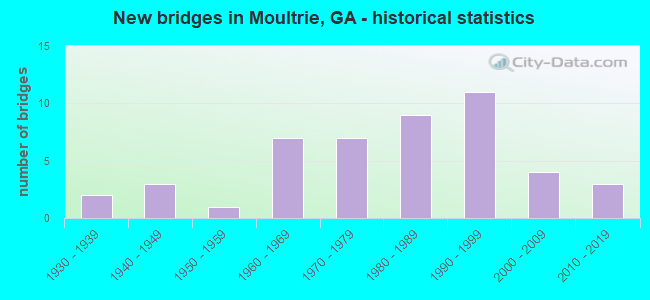
- New bridges - historical statistics
- 21930-1939
- 31940-1949
- 11950-1959
- 71960-1969
- 71970-1979
- 91980-1989
- 111990-1999
- 42000-2009
- 32010-2019
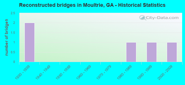
- Reconstructed bridges - Historical Statistics
- 21930-1939
- 01940-1949
- 01950-1959
- 01960-1969
- 01970-1979
- 11980-1989
- 11990-1999
- 12000-2009
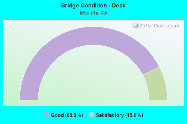
- Bridge Condition - Deck
- 85.0%Good
- 15.0%Satisfactory
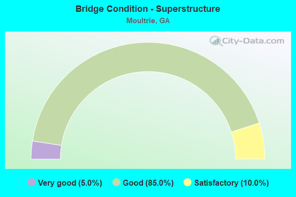
- Bridge Condition - Superstructure
- 5.0%Very good
- 85.0%Good
- 10.0%Satisfactory
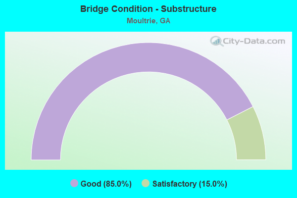
- Bridge Condition - Substructure
- 85.0%Good
- 15.0%Satisfactory
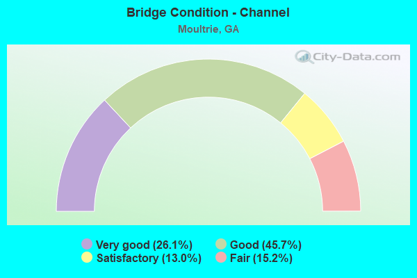
- Bridge Condition - Channel
- 26.1%Very good
- 45.7%Good
- 13.0%Satisfactory
- 15.2%Fair
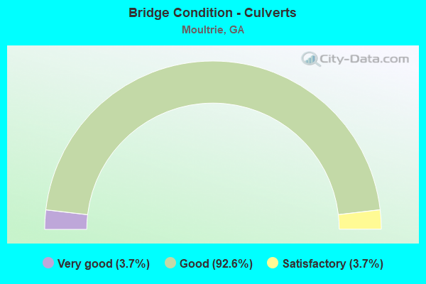
- Bridge Condition - Culverts
- 3.7%Very good
- 92.6%Good
- 3.7%Satisfactory
Find on map >> Show street view
Structure Number: 710004, Location: APP 1.5 MI N OF MOULTRIE (Lat: 31.214389, Lng: -83.784039), Route carried "on" structure: State highway 33, Year Built: 1980, Status: Open, Structure Length: 4.63m (15.19ft), Average Daily Traffic: 7,290 (year 2011), Truck Traffic: 1%, Average Future Daily Traffic: 10,935 (year 2031), Design Load: HS 20+Mod, Features Intersected: OKAPILCO CREEK
Minimum Vertical Clearance: 30+ m (98+ ft), Kilometerpoint: 20.921, Lanes on structure: 2, Base Highway Network: Yes, Owner: State Highway Agency, Approaching Roadway Width: 9.8m (32.2ft), Skew: 2 degrees, Material/Design: Concrete, Design/Construction: Tee Beam, Number Of Spans In Main Unit: 5, Length of Maximum Span: 9.1m (29.9ft), Curb-To-Curb Width: 13.4m (44.0ft), Out-to-Out Width: 14.4m (47.2ft)
Condition: Deck: Good, Superstructure: Good, Substructure: Good, Channel: Good, Operating Rating: 63.5 metric tons, Method Used To Determine Operating Rating: Load Factor (LF), Inventory Rating: 38.1 metric tons, Method Used To Determine Inventory Rating: Load Factor (LF), Structural Evaluation: Better than present minimum criteria, Deck Geometry: Equal to present minimum criteria, Waterway Adequacy: Equal to present desirable criteria, Approach Roadway Alignment: Equal to present desirable criteria, Designated Inspection Frequency: Every 24 months, Inspection Date: January 2021, Bridge Improvement Cost: $586,000, Roadway Improvement Cost: $59,000, Total Project Cost: $879,000, Deck Structure Type: Concrete Cast-file-Place
Find on map >> Show street view
Structure Number: 710005, Location: APP 3 MI S OF MOULTRIE (Lat: 31.130169, Lng: -83.772839), Route carried "on" structure: US 319, Year Built: 1978, Year Reconstructed: 1993, Status: Open, Structure Length: 0.82m (2.69ft), Average Daily Traffic: 9,080 (year 2011), Truck Traffic: 1%, Average Future Daily Traffic: 13,620 (year 2031), Design Load: HS 20+Mod, Features Intersected: SLOANS CREEK
Minimum Vertical Clearance: 30+ m (98+ ft), Kilometerpoint: 12.875, Lanes on structure: 4, Base Highway Network: Yes, Owner: State Highway Agency, Approaching Roadway Width: 20.1m (65.9ft), Skew: 10 degrees, Material/Design: Concrete, Design/Construction: Culvert, Number Of Spans In Main Unit: 4, Length of Maximum Span: 1.8m (5.9ft)
Condition: Channel: Very good, Culverts: Good, Operating Rating: 56.2 metric tons, Method Used To Determine Operating Rating: Load Factor (LF), Inventory Rating: 33.5 metric tons, Method Used To Determine Inventory Rating: Load Factor (LF), Structural Evaluation: Better than present minimum criteria, Waterway Adequacy: Equal to present desirable criteria, Approach Roadway Alignment: Better than present minimum criteria, Designated Inspection Frequency: Every 24 months, Inspection Date: Febuary 2021, Bridge Improvement Cost: $163,000, Roadway Improvement Cost: $16,000, Total Project Cost: $245,000
Find on map >> Show street view
Structure Number: 710006, Location: APP 1.5 MI S OF MOULTRIE (Lat: 31.163256, Lng: -83.761561), Route carried "on" structure: US 319, Year Built: 1978, Status: Open, Structure Length: 6.95m (22.80ft), Average Daily Traffic: 16,050 (year 2011), Truck Traffic: 1%, Average Future Daily Traffic: 24,075 (year 2031), Design Load: HS 20, Features Intersected: OKAPILCO CREEK
Minimum Vertical Clearance: 30+ m (98+ ft), Kilometerpoint: 16.093, Lanes on structure: 2, Base Highway Network: Yes, Owner: State Highway Agency, Approaching Roadway Width: 9.8m (32.2ft), Skew: 14 degrees, Material/Design: Concrete, Design/Construction: Tee Beam, Number Of Spans In Main Unit: 6, Length of Maximum Span: 11.6m (38.1ft), Curb-To-Curb Width: 13.0m (42.7ft), Out-to-Out Width: 14.0m (45.9ft)
Condition: Deck: Good, Superstructure: Good, Substructure: Good, Channel: Good, Operating Rating: 39.9 metric tons, Method Used To Determine Operating Rating: Load Factor (LF), Inventory Rating: 23.5 metric tons, Method Used To Determine Inventory Rating: Load Factor (LF), Structural Evaluation: Somewhat better than minimum adequacy, Deck Geometry: Superior to present desirable criteria, Waterway Adequacy: Equal to present desirable criteria, Approach Roadway Alignment: Better than present minimum criteria, Designated Inspection Frequency: Every 24 months, Inspection Date: Febuary 2021, Bridge Improvement Cost: $891,000, Roadway Improvement Cost: $89,000, Total Project Cost: $1,336,000, Deck Structure Type: Concrete Cast-file-Place
Find on map >> Show street view
Structure Number: 710018, Location: WEST MOULTRIE (Lat: 31.182619, Lng: -83.809069), Route carried "on" structure: State highway 37, Year Built: 1948, Status: Open, Structure Length: 7.62m (25.00ft), Average Daily Traffic: 10,680 (year 2011), Truck Traffic: 1%, Average Future Daily Traffic: 16,020 (year 2031), Design Load: H 15, Features Intersected: OCHLOCKONEE RIVER
Minimum Vertical Clearance: 30+ m (98+ ft), Kilometerpoint: 19.312, Lanes on structure: 2, Base Highway Network: Yes, Owner: State Highway Agency, Approaching Roadway Width: 7.3m (24.0ft), Material/Design: Steel, Design/Construction: Stringer/Multi-beam, Number Of Spans In Main Unit: 5, Length of Maximum Span: 18.3m (60.0ft), Curb or Sidewalk Widths: Left: 1.5m (4.9ft), Right: 0.6m (2.0ft), Curb-To-Curb Width: 8.5m (27.9ft), Out-to-Out Width: 11.3m (37.1ft)
Condition: Deck: Satisfactory, Superstructure: Satisfactory, Substructure: Satisfactory, Channel: Very good, Operating Rating: 31.7 metric tons, Method Used To Determine Operating Rating: Load Factor (LF), Inventory Rating: 18.1 metric tons, Method Used To Determine Inventory Rating: Load Factor (LF), Structural Evaluation: Meets minimum limits, Deck Geometry: Meets minimum limits, Waterway Adequacy: Equal to present minimum criteria, Approach Roadway Alignment: Equal to present minimum criteria, Length Of Structure Improvement: 14.14m (46.39ft), Designated Inspection Frequency: Every 24 months, Underwater Inspection Frequency: Every 60 months, Inspection Date: Febuary 2021, Underwater Inspection Date: March 2018, Bridge Improvement Cost: $977,000, Roadway Improvement Cost: $98,000, Total Project Cost: $1,465,000, Deck Structure Type: Concrete Cast-file-Place
Find on map >> Show street view
Structure Number: 71002, Location: APP 3.2 MI E OFMOULTRIE (Lat: 31.191606, Lng: -83.735742), Route carried "on" structure: State highway 37, Year Built: 1932, Year Reconstructed: 1939, Status: Open, Structure Length: 1.07m (3.51ft), Average Daily Traffic: 3,640 (year 2011), Truck Traffic: 16%, Average Future Daily Traffic: 5,460 (year 2031), Design Load: H 15, Features Intersected: LITTLE INDIAN CREEK
Minimum Vertical Clearance: 30+ m (98+ ft), Kilometerpoint: 28.968, Lanes on structure: 2, Base Highway Network: Yes, Owner: State Highway Agency, Approaching Roadway Width: 8.5m (27.9ft), Material/Design: Concrete, Design/Construction: Culvert, Number Of Spans In Main Unit: 4, Length of Maximum Span: 2.4m (7.9ft), Curb-To-Curb Width: 9.8m (32.2ft), Out-to-Out Width: 10.5m (34.4ft)
Condition: Channel: Satisfactory, Culverts: Good, Operating Rating: 41.7 metric tons, Method Used To Determine Operating Rating: Load Factor (LF), Inventory Rating: 25.4 metric tons, Method Used To Determine Inventory Rating: Load Factor (LF), Structural Evaluation: Equal to present minimum criteria, Deck Geometry: Meets minimum limits, Waterway Adequacy: Equal to present minimum criteria, Approach Roadway Alignment: Better than present minimum criteria, Length Of Structure Improvement: 7.50m (24.61ft), Designated Inspection Frequency: Every 24 months, Inspection Date: Febuary 2021, Bridge Improvement Cost: $137,000, Roadway Improvement Cost: $14,000, Total Project Cost: $205,000
Find on map >> Show street view
Structure Number: 710021, Location: APP 4 MI E OF MOULTRIE (Lat: 31.187650, Lng: -83.719239), Route carried "on" structure: State highway 37, Year Built: 1932, Year Reconstructed: 1939, Status: Open, Structure Length: 1.34m (4.40ft), Average Daily Traffic: 3,640 (year 2011), Truck Traffic: 16%, Average Future Daily Traffic: 5,460 (year 2031), Design Load: H 15, Features Intersected: INDIAN CREEK
Minimum Vertical Clearance: 30+ m (98+ ft), Kilometerpoint: 30.578, Lanes on structure: 2, Base Highway Network: Yes, Owner: State Highway Agency, Approaching Roadway Width: 8.5m (27.9ft), Material/Design: Concrete, Design/Construction: Culvert, Number Of Spans In Main Unit: 5, Length of Maximum Span: 2.4m (7.9ft), Curb-To-Curb Width: 9.8m (32.2ft), Out-to-Out Width: 10.5m (34.4ft)
Condition: Channel: Very good, Culverts: Good, Operating Rating: 45.3 metric tons, Method Used To Determine Operating Rating: Load Factor (LF), Inventory Rating: 27.2 metric tons, Method Used To Determine Inventory Rating: Load Factor (LF), Structural Evaluation: Equal to present minimum criteria, Deck Geometry: Meets minimum limits, Waterway Adequacy: Equal to present minimum criteria, Approach Roadway Alignment: Equal to present minimum criteria, Length Of Structure Improvement: 7.83m (25.69ft), Designated Inspection Frequency: Every 24 months, Inspection Date: Febuary 2021, Bridge Improvement Cost: $172,000, Roadway Improvement Cost: $17,000, Total Project Cost: $258,000
Find on map >> Show street view
Structure Number: 710035, Location: APP 7.75 MI S OF MOULTRIE (Lat: 31.065106, Lng: -83.764403), Route carried "on" structure: State highway 33, Year Built: 1949, Status: Open, Structure Length: 1.01m (3.31ft), Average Daily Traffic: 2,620 (year 2011), Truck Traffic: 1%, Average Future Daily Traffic: 3,930 (year 2031), Design Load: H 15, Features Intersected: HOG CREEK
Minimum Vertical Clearance: 30+ m (98+ ft), Kilometerpoint: 3.219, Lanes on structure: 2, Base Highway Network: Yes, Owner: State Highway Agency, Approaching Roadway Width: 8.5m (27.9ft), Skew: 3 degrees, Material/Design: Concrete, Design/Construction: Culvert, Number Of Spans In Main Unit: 3, Length of Maximum Span: 3.0m (9.8ft)
Condition: Channel: Good, Culverts: Good, Operating Rating: 48.9 metric tons, Method Used To Determine Operating Rating: Load Factor (LF), Inventory Rating: 29.0 metric tons, Method Used To Determine Inventory Rating: Load Factor (LF), Structural Evaluation: Better than present minimum criteria, Waterway Adequacy: Equal to present desirable criteria, Approach Roadway Alignment: Better than present minimum criteria, Designated Inspection Frequency: Every 24 months, Inspection Date: January 2021, Bridge Improvement Cost: $129,000, Roadway Improvement Cost: $13,000, Total Project Cost: $193,000
Find on map >> Show street view
Structure Number: 710037, Location: NORTH MOULTRIE (Lat: 31.200808, Lng: -83.786308), Route carried "on" structure: State highway 33, Year Built: 1956, Status: Open, Structure Length: 1.92m (6.30ft), Average Daily Traffic: 6,980 (year 2011), Truck Traffic: 1%, Average Future Daily Traffic: 10,470 (year 2031), Design Load: H 15, Features Intersected: OKAPILCO CREEK
Minimum Vertical Clearance: 30+ m (98+ ft), Kilometerpoint: 19.312, Lanes on structure: 4, Base Highway Network: Yes, Owner: State Highway Agency, Approaching Roadway Width: 20.1m (65.9ft), Skew: 3 degrees, Material/Design: Concrete, Design/Construction: Culvert, Number Of Spans In Main Unit: 4, Length of Maximum Span: 4.6m (15.1ft), Curb or Sidewalk Widths: Left: 0.2m (0.7ft), Right: 0.2m (0.7ft)
Condition: Channel: Good, Culverts: Good, Operating Rating: 77.1 metric tons, Method Used To Determine Operating Rating: Load Factor (LF), Inventory Rating: 46.2 metric tons, Method Used To Determine Inventory Rating: Load Factor (LF), Structural Evaluation: Better than present minimum criteria, Waterway Adequacy: Equal to present desirable criteria, Approach Roadway Alignment: Equal to present desirable criteria, Designated Inspection Frequency: Every 24 months, Inspection Date: January 2021, Bridge Improvement Cost: $380,000, Roadway Improvement Cost: $38,000, Total Project Cost: $571,000
Find on map >> Show street view
Structure Number: 710046, Location: APP .5 MI NE OF MOULTRIE (Lat: 31.199878, Lng: -83.747058), Route carried "on" structure: County highway 548, Year Built: 1986, Status: Open, Structure Length: 0.82m (2.69ft), Average Daily Traffic: 1,570 (year 2011), Truck Traffic: 1%, Average Future Daily Traffic: 2,355 (year 2031), Design Load: HS 20+Mod, Features Intersected: LITTLE INDIAN CREEK, Facility Carried by Structure: COOL SPRINGS ROAD
Minimum Vertical Clearance: 30+ m (98+ ft), Kilometerpoint: 0.000, Lanes on structure: 2, Base Highway Network: Yes, Owner: County Highway Agency, Approaching Roadway Width: 6.1m (20.0ft), Skew: 1 degrees, Material/Design: Concrete, Design/Construction: Culvert, Number Of Spans In Main Unit: 3, Length of Maximum Span: 2.4m (7.9ft)
Condition: Channel: Good, Culverts: Good, Operating Rating: 55.3 metric tons, Method Used To Determine Operating Rating: Field evaluation and documented engineering judgment, Inventory Rating: 32.6 metric tons, Method Used To Determine Inventory Rating: Field evaluation and documented engineering judgment, Structural Evaluation: Better than present minimum criteria, Waterway Adequacy: Equal to present desirable criteria, Approach Roadway Alignment: Equal to present desirable criteria, Designated Inspection Frequency: Every 24 months, Inspection Date: Febuary 2021, Bridge Improvement Cost: $105,000, Roadway Improvement Cost: $11,000, Total Project Cost: $158,000
Find on map >> Show street view
Structure Number: 710058, Location: 4.5 MI SW OF MOULTRIE (Lat: 31.123347, Lng: -83.845478), Route carried "on" structure: County highway 1205, Year Built: 1979, Status: Open, Structure Length: 4.57m (14.99ft), Average Daily Traffic: 1,140 (year 2011), Truck Traffic: 1%, Average Future Daily Traffic: 1,710 (year 2031), Design Load: HS 15, Features Intersected: OCHLOCKONEE RIVER TRIB, Facility Carried by Structure: LOWER MEIGS ROAD
Minimum Vertical Clearance: 30+ m (98+ ft), Kilometerpoint: 17.703, Lanes on structure: 2, Base Highway Network: Yes, Owner: County Highway Agency, Approaching Roadway Width: 7.0m (23.0ft), Material/Design: Concrete, Design/Construction: Tee Beam, Number Of Spans In Main Unit: 5, Length of Maximum Span: 9.1m (29.9ft), Curb-To-Curb Width: 9.3m (30.5ft), Out-to-Out Width: 10.3m (33.8ft)
Condition: Deck: Good, Superstructure: Good, Substructure: Good, Channel: Good, Operating Rating: 39.9 metric tons, Method Used To Determine Operating Rating: Load Factor (LF), Inventory Rating: 24.4 metric tons, Method Used To Determine Inventory Rating: Load Factor (LF), Structural Evaluation: Equal to present minimum criteria, Deck Geometry: Somewhat better than minimum adequacy, Waterway Adequacy: Equal to present desirable criteria, Approach Roadway Alignment: Better than present minimum criteria, Designated Inspection Frequency: Every 24 months, Underwater Inspection Frequency: Every 60 months, Inspection Date: December 2020, Underwater Inspection Date: March 2018, Bridge Improvement Cost: $586,000, Roadway Improvement Cost: $59,000, Total Project Cost: $879,000, Deck Structure Type: Concrete Cast-file-Place
Find on map >> Show street view
Structure Number: 710059, Location: APP 4.5 MI W OF MOULTRIE (Lat: 31.133547, Lng: -83.825578), Route carried "on" structure: County highway 1205, Year Built: 1979, Status: Open, Structure Length: 0.64m (2.10ft), Average Daily Traffic: 1,140 (year 2011), Truck Traffic: 1%, Average Future Daily Traffic: 1,710 (year 2031), Design Load: HS 20+Mod, Features Intersected: OCHLOCKONEE RIVER TRIB, Facility Carried by Structure: LOWER MEIGS ROAD
Minimum Vertical Clearance: 30+ m (98+ ft), Kilometerpoint: 19.312, Lanes on structure: 2, Base Highway Network: Yes, Owner: County Highway Agency, Approaching Roadway Width: 7.0m (23.0ft), Material/Design: Concrete, Design/Construction: Culvert, Number Of Spans In Main Unit: 2, Length of Maximum Span: 3.0m (9.8ft)
Condition: Channel: Good, Culverts: Good, Operating Rating: 55.3 metric tons, Method Used To Determine Operating Rating: Field evaluation and documented engineering judgment, Inventory Rating: 32.6 metric tons, Method Used To Determine Inventory Rating: Field evaluation and documented engineering judgment, Structural Evaluation: Better than present minimum criteria, Waterway Adequacy: Equal to present minimum criteria, Approach Roadway Alignment: Better than present minimum criteria, Designated Inspection Frequency: Every 24 months, Inspection Date: December 2020, Bridge Improvement Cost: $82,000, Roadway Improvement Cost: $8,000, Total Project Cost: $123,000
Find on map >> Show street view
Structure Number: 71006, Location: APP 3 MI SW OF MOULTRIE (Lat: 31.142108, Lng: -83.803278), Route carried "on" structure: County highway 1205, Year Built: 1974, Status: Posted for load, Structure Length: 9.88m (32.41ft), Average Daily Traffic: 2,100 (year 2011), Truck Traffic: 1%, Average Future Daily Traffic: 3,150 (year 2031), Design Load: HS 15, Features Intersected: OCKLOCKONEE RIVER, Facility Carried by Structure: LOWER MEIGS ROAD
Minimum Vertical Clearance: 30+ m (98+ ft), Kilometerpoint: 22.531, Lanes on structure: 2, Base Highway Network: Yes, Owner: County Highway Agency, Approaching Roadway Width: 6.7m (22.0ft), Material/Design: Concrete, Design/Construction: Tee Beam, Number Of Spans In Main Unit: 9, Length of Maximum Span: 11.0m (36.1ft), Curb or Sidewalk Widths: Left: 0.2m (0.7ft), Right: 0.2m (0.7ft), Curb-To-Curb Width: 9.4m (30.8ft), Out-to-Out Width: 10.5m (34.4ft)
Condition: Deck: Good, Superstructure: Good, Substructure: Good, Channel: Fair, Operating Rating: 30.8 metric tons, Method Used To Determine Operating Rating: Load Factor (LF), Inventory Rating: 18.1 metric tons, Method Used To Determine Inventory Rating: Load Factor (LF), Structural Evaluation: Somewhat better than minimum adequacy, Deck Geometry: Meets minimum limits, Waterway Adequacy: Equal to present desirable criteria, Approach Roadway Alignment: Better than present minimum criteria, Bridge Posting: Required (Relationship of Operating Rating to Maximum Legal Load: 0.1 - 9.9% below), Designated Inspection Frequency: Every 24 months, Underwater Inspection Frequency: Every 60 months, Inspection Date: December 2020, Underwater Inspection Date: March 2018, Bridge Improvement Cost: $1,266,000, Roadway Improvement Cost: $127,000, Total Project Cost: $1,899,000, Deck Structure Type: Concrete Cast-file-Place
Find on map >> Show street view
Structure Number: 710063, Location: APP 5 MI NW OF MOULTRIE (Lat: 31.229378, Lng: -83.834908), Route carried "on" structure: County highway 1751, Year Built: 1947, Status: Open, Structure Length: 9.88m (32.41ft), Average Daily Traffic: 1,530 (year 2011), Truck Traffic: 1%, Average Future Daily Traffic: 2,295 (year 2031), Design Load: H 15, Features Intersected: OCHLOCKONEE RIVER, Facility Carried by Structure: OLD DOERUN ROAD
Minimum Vertical Clearance: 30+ m (98+ ft), Kilometerpoint: 8.047, Lanes on structure: 2, Base Highway Network: Yes, Owner: County Highway Agency, Approaching Roadway Width: 7.3m (24.0ft), Material/Design: Steel continuous, Design/Construction: Stringer/Multi-beam, Number Of Spans In Main Unit: 12, Length of Maximum Span: 8.2m (26.9ft), Curb or Sidewalk Widths: Left: 0.6m (2.0ft), Right: 0.6m (2.0ft), Curb-To-Curb Width: 7.3m (24.0ft), Out-to-Out Width: 9.2m (30.2ft)
Condition: Deck: Satisfactory, Superstructure: Satisfactory, Substructure: Satisfactory, Channel: Fair, Operating Rating: 45.3 metric tons, Method Used To Determine Operating Rating: Load Factor (LF), Inventory Rating: 27.2 metric tons, Method Used To Determine Inventory Rating: Load Factor (LF), Structural Evaluation: Equal to present minimum criteria, Deck Geometry: Meets minimum limits, Waterway Adequacy: Equal to present minimum criteria, Approach Roadway Alignment: Equal to present minimum criteria, Length Of Structure Improvement: 16.31m (53.51ft), Designated Inspection Frequency: Every 24 months, Underwater Inspection Frequency: Every 60 months, Inspection Date: January 2021, Underwater Inspection Date: March 2018, Bridge Improvement Cost: $1,266,000, Roadway Improvement Cost: $127,000, Total Project Cost: $1,899,000, Deck Structure Type: Concrete Cast-file-Place
Find on map >> Show street view
Structure Number: 710079, Location: APP 3 MI N OF MOULTRIE (Lat: 31.216308, Lng: -83.783647), Route carried "on" structure: County highway 2729, Year Built: 1980, Status: Open, Structure Length: 4.88m (16.01ft), Average Daily Traffic: 430 (year 2011), Truck Traffic: 1%, Average Future Daily Traffic: 645 (year 2031), Design Load: HS 15, Features Intersected: OKAPILCO CREEK, Facility Carried by Structure: WOODMEN ROAD
Minimum Vertical Clearance: 30+ m (98+ ft), Kilometerpoint: 3.219, Lanes on structure: 2, Base Highway Network: Yes, Owner: County Highway Agency, Approaching Roadway Width: 6.1m (20.0ft), Material/Design: Concrete, Design/Construction: Tee Beam, Number Of Spans In Main Unit: 4, Length of Maximum Span: 12.2m (40.0ft), Curb-To-Curb Width: 12.3m (40.4ft), Out-to-Out Width: 13.4m (44.0ft)
Condition: Deck: Good, Superstructure: Good, Substructure: Good, Channel: Fair, Operating Rating: 39.9 metric tons, Method Used To Determine Operating Rating: Load Factor (LF), Inventory Rating: 23.5 metric tons, Method Used To Determine Inventory Rating: Load Factor (LF), Structural Evaluation: Equal to present minimum criteria, Deck Geometry: Superior to present desirable criteria, Waterway Adequacy: Equal to present desirable criteria, Approach Roadway Alignment: Equal to present desirable criteria, Designated Inspection Frequency: Every 24 months, Inspection Date: January 2021, Bridge Improvement Cost: $625,000, Roadway Improvement Cost: $63,000, Total Project Cost: $938,000, Deck Structure Type: Concrete Cast-file-Place
Find on map >> Show street view
Structure Number: 71008, Location: SE MOULTRIE (Lat: 31.174192, Lng: -83.772167), Route carried "on" structure: City street 3406, Year Built: 1982, Status: Open, Structure Length: 4.88m (16.01ft), Average Daily Traffic: 7,990 (year 2011), Truck Traffic: 1%, Average Future Daily Traffic: 11,985 (year 2031), Design Load: HS 20+Mod, Features Intersected: OKAPILCO CREEK, Facility Carried by Structure: SE 5TH AVE.
Minimum Vertical Clearance: 30+ m (98+ ft), Kilometerpoint: 1.609, Lanes on structure: 2, Base Highway Network: Yes, Owner: City or Municipal Highway Agency, Approaching Roadway Width: 7.0m (23.0ft), Skew: 4 degrees, Material/Design: Concrete, Design/Construction: Tee Beam, Number Of Spans In Main Unit: 4, Length of Maximum Span: 12.2m (40.0ft), Curb-To-Curb Width: 14.6m (47.9ft), Out-to-Out Width: 15.9m (52.2ft)
Condition: Deck: Good, Superstructure: Good, Substructure: Good, Channel: Very good, Operating Rating: 58.9 metric tons, Method Used To Determine Operating Rating: Load Factor (LF), Inventory Rating: 35.3 metric tons, Method Used To Determine Inventory Rating: Load Factor (LF), Structural Evaluation: Better than present minimum criteria, Deck Geometry: Superior to present desirable criteria, Waterway Adequacy: Equal to present desirable criteria, Approach Roadway Alignment: Equal to present desirable criteria, Designated Inspection Frequency: Every 24 months, Inspection Date: Febuary 2021, Bridge Improvement Cost: $625,000, Roadway Improvement Cost: $63,000, Total Project Cost: $938,000, Deck Structure Type: Concrete Cast-file-Place
Find on map >> Show street view
Structure Number: 71009, Location: APP 1.5 MI S MOULTRIE (Lat: 31.163378, Lng: -83.761778), Route carried "on" structure: US 319, Year Built: 1992, Status: Open, Structure Length: 6.95m (22.80ft), Average Daily Traffic: 16,050 (year 2011), Truck Traffic: 1%, Average Future Daily Traffic: 24,075 (year 2031), Design Load: HS 20+Mod, Features Intersected: OKAPILCO CREEK
Minimum Vertical Clearance: 30+ m (98+ ft), Kilometerpoint: 16.093, Lanes on structure: 2, Base Highway Network: Yes, Owner: State Highway Agency, Approaching Roadway Width: 10.1m (33.1ft), Skew: 14 degrees, Material/Design: Concrete, Design/Construction: Tee Beam, Number Of Spans In Main Unit: 6, Length of Maximum Span: 11.6m (38.1ft), Curb-To-Curb Width: 11.6m (38.1ft), Out-to-Out Width: 12.6m (41.3ft)
Condition: Deck: Good, Superstructure: Good, Substructure: Good, Channel: Very good, Operating Rating: 68.0 metric tons, Method Used To Determine Operating Rating: Load Factor (LF), Inventory Rating: 40.8 metric tons, Method Used To Determine Inventory Rating: Load Factor (LF), Structural Evaluation: Better than present minimum criteria, Deck Geometry: Better than present minimum criteria, Waterway Adequacy: Equal to present desirable criteria, Approach Roadway Alignment: Better than present minimum criteria, Designated Inspection Frequency: Every 24 months, Inspection Date: Febuary 2021, Bridge Improvement Cost: $891,000, Roadway Improvement Cost: $89,000, Total Project Cost: $1,336,000, Deck Structure Type: Concrete Cast-file-Place
Find on map >> Show street view
Structure Number: 710091, Location: APP 7 MI E OF MOULTRIE (Lat: 31.179908, Lng: -83.681928), Route carried "on" structure: State highway 37, Year Built: 1993, Status: Open, Structure Length: 3.11m (10.20ft), Average Daily Traffic: 3,640 (year 2011), Truck Traffic: 16%, Average Future Daily Traffic: 5,460 (year 2031), Design Load: HS 20+Mod, Features Intersected: BEAR CREEK
Minimum Vertical Clearance: 30+ m (98+ ft), Kilometerpoint: 33.796, Lanes on structure: 2, Base Highway Network: Yes, Owner: State Highway Agency, Approaching Roadway Width: 8.5m (27.9ft), Material/Design: Concrete, Design/Construction: Tee Beam, Number Of Spans In Main Unit: 3, Length of Maximum Span: 10.4m (34.1ft), Curb-To-Curb Width: 12.2m (40.0ft), Out-to-Out Width: 13.2m (43.3ft)
Condition: Deck: Good, Superstructure: Good, Substructure: Good, Channel: Good, Operating Rating: 61.6 metric tons, Method Used To Determine Operating Rating: Load Factor (LF), Inventory Rating: 36.2 metric tons, Method Used To Determine Inventory Rating: Load Factor (LF), Structural Evaluation: Better than present minimum criteria, Deck Geometry: Equal to present minimum criteria, Waterway Adequacy: Equal to present desirable criteria, Approach Roadway Alignment: Equal to present desirable criteria, Designated Inspection Frequency: Every 24 months, Inspection Date: Febuary 2021, Bridge Improvement Cost: $399,000, Roadway Improvement Cost: $40,000, Total Project Cost: $598,000, Deck Structure Type: Concrete Cast-file-Place
Find on map >> Show street view
Structure Number: 710093, Location: NORTH MOULTRIE (Lat: 31.190239, Lng: -83.787597), Route carried "on" structure: Business US 319, Year Built: 1994, Status: Open, Structure Length: 7.56m (24.80ft), Average Daily Traffic: 3,670 (year 2011), Truck Traffic: 1%, Average Future Daily Traffic: 5,505 (year 2031), Design Load: HS 20+Mod, Features Intersected: CSX RAILROAD
Minimum Vertical Clearance: 30+ m (98+ ft), Kilometerpoint: 17.703, Lanes on structure: 4, Base Highway Network: Yes, Owner: State Highway Agency, Approaching Roadway Width: 15.8m (51.8ft), Skew: 4 degrees, Material/Design: Prestressed concrete, Design/Construction: Stringer/Multi-beam, Number Of Spans In Main Unit: 3, Length of Maximum Span: 34.4m (112.9ft), Curb or Sidewalk Widths: Left: 1.8m (5.9ft), Right: 1.8m (5.9ft), Curb-To-Curb Width: 15.8m (51.8ft), Out-to-Out Width: 20.2m (66.3ft)
Condition: Deck: Good, Superstructure: Good, Substructure: Good, Operating Rating: 59.8 metric tons, Method Used To Determine Operating Rating: Load Factor (LF), Inventory Rating: 36.2 metric tons, Method Used To Determine Inventory Rating: Load Factor (LF), Structural Evaluation: Better than present minimum criteria, Deck Geometry: Meets minimum limits, Underclear: Superior to present desirable criteria, Approach Roadway Alignment: Equal to present desirable criteria, Designated Inspection Frequency: Every 24 months, Inspection Date: January 2021, Bridge Improvement Cost: $1,498,000, Roadway Improvement Cost: $150,000, Total Project Cost: $2,246,000, Deck Structure Type: Concrete Cast-file-Place
Find on map >> Show street view
Structure Number: 715008, Location: 5.5 MI SE OF MOULTRIE (Lat: 31.103100, Lng: -83.760528), Route carried "on" structure: County highway 15, Year Built: 1969, Status: Open, Structure Length: 0.98m (3.22ft), Average Daily Traffic: 560 (year 2011), Truck Traffic: 1%, Average Future Daily Traffic: 840 (year 2031), Design Load: H 15, Features Intersected: SLOANS CREEK, Facility Carried by Structure: EAST SUNSET RD
Minimum Vertical Clearance: 30+ m (98+ ft), Kilometerpoint: 12.875, Lanes on structure: 2, Base Highway Network: Yes, Owner: County Highway Agency, Approaching Roadway Width: 5.5m (18.0ft), Material/Design: Concrete, Design/Construction: Culvert, Number Of Spans In Main Unit: 4, Length of Maximum Span: 2.4m (7.9ft)
Condition: Channel: Satisfactory, Culverts: Satisfactory, Operating Rating: 41.7 metric tons, Method Used To Determine Operating Rating: Field evaluation and documented engineering judgment, Inventory Rating: 24.4 metric tons, Method Used To Determine Inventory Rating: Field evaluation and documented engineering judgment, Structural Evaluation: Equal to present minimum criteria, Waterway Adequacy: Better than present minimum criteria, Approach Roadway Alignment: Better than present minimum criteria, Designated Inspection Frequency: Every 24 months, Underwater Inspection Frequency: Every 60 months, Inspection Date: January 2021, Underwater Inspection Date: March 2018, Bridge Improvement Cost: $125,000, Roadway Improvement Cost: $13,000, Total Project Cost: $188,000
Find on map >> Show street view
Structure Number: 715017, Location: 3.8 MI SW OF MOULTRIE (Lat: 31.141853, Lng: -83.842694), Route carried "on" structure: County highway 28, Year Built: 1992, Status: Open, Structure Length: 1.37m (4.49ft), Average Daily Traffic: 580 (year 2011), Truck Traffic: 1%, Average Future Daily Traffic: 870 (year 2031), Design Load: HS 20+Mod, Features Intersected: OCHLOCKONEE RIVER TRIB, Facility Carried by Structure: PAUL MURPHY RD
Minimum Vertical Clearance: 30+ m (98+ ft), Kilometerpoint: 3.219, Lanes on structure: 2, Base Highway Network: Yes, Owner: County Highway Agency, Approaching Roadway Width: 6.1m (20.0ft), Material/Design: Concrete, Design/Construction: Culvert, Number Of Spans In Main Unit: 5, Length of Maximum Span: 2.4m (7.9ft)
Condition: Channel: Good, Culverts: Good, Operating Rating: 55.3 metric tons, Method Used To Determine Operating Rating: Field evaluation and documented engineering judgment, Inventory Rating: 32.6 metric tons, Method Used To Determine Inventory Rating: Field evaluation and documented engineering judgment, Structural Evaluation: Better than present minimum criteria, Waterway Adequacy: Better than present minimum criteria, Approach Roadway Alignment: Equal to present desirable criteria, Designated Inspection Frequency: Every 24 months, Inspection Date: December 2020, Bridge Improvement Cost: $176,000, Roadway Improvement Cost: $18,000, Total Project Cost: $264,000
Find on map >> Show street view
Structure Number: 715037, Location: 4.9 MI SW NORMAN PARK (Lat: 31.235358, Lng: -83.760450), Route carried "on" structure: County highway 89, Year Built: 1994, Status: Open, Structure Length: 0.70m (2.30ft), Average Daily Traffic: 530 (year 2011), Truck Traffic: 1%, Average Future Daily Traffic: 795 (year 2031), Design Load: HS 20+Mod, Features Intersected: LITTLE INDIAN CREEK, Facility Carried by Structure: ROB BENNETT DR
Minimum Vertical Clearance: 30+ m (98+ ft), Kilometerpoint: 1.609, Lanes on structure: 2, Base Highway Network: Yes, Owner: County Highway Agency, Approaching Roadway Width: 7.0m (23.0ft), Material/Design: Concrete, Design/Construction: Culvert, Number Of Spans In Main Unit: 3, Length of Maximum Span: 2.1m (6.9ft)
Condition: Channel: Good, Culverts: Good, Operating Rating: 55.3 metric tons, Method Used To Determine Operating Rating: Field evaluation and documented engineering judgment, Inventory Rating: 32.6 metric tons, Method Used To Determine Inventory Rating: Field evaluation and documented engineering judgment, Structural Evaluation: Better than present minimum criteria, Waterway Adequacy: Better than present minimum criteria, Approach Roadway Alignment: Equal to present desirable criteria, Designated Inspection Frequency: Every 24 months, Inspection Date: January 2021, Bridge Improvement Cost: $90,000, Roadway Improvement Cost: $9,000, Total Project Cost: $135,000
Find on map >> Show street view
Structure Number: 715049, Location: APP 7.5 MI SE OF MOULTRIE (Lat: 31.104128, Lng: -83.687858), Route carried "on" structure: County highway 111, Year Built: 1985, Year Reconstructed: 2012, Status: Open, Structure Length: 1.49m (4.89ft), Average Daily Traffic: 490 (year 2012), Truck Traffic: 1%, Average Future Daily Traffic: 735 (year 2032), Design Load: HS 20+Mod, Features Intersected: LITTLE CREEK, Facility Carried by Structure: COOK ROAD
Minimum Vertical Clearance: 30+ m (98+ ft), Kilometerpoint: 4.828, Lanes on structure: 2, Base Highway Network: Yes, Owner: County Highway Agency, Approaching Roadway Width: 5.8m (19.0ft), Skew: 4 degrees, Material/Design: Concrete, Design/Construction: Culvert, Number Of Spans In Main Unit: 3, Length of Maximum Span: 4.3m (14.1ft)
Condition: Channel: Good, Culverts: Good, Operating Rating: 55.3 metric tons, Method Used To Determine Operating Rating: Field evaluation and documented engineering judgment, Inventory Rating: 32.6 metric tons, Method Used To Determine Inventory Rating: Field evaluation and documented engineering judgment, Structural Evaluation: Better than present minimum criteria, Waterway Adequacy: Better than present minimum criteria, Approach Roadway Alignment: Better than present minimum criteria, Designated Inspection Frequency: Every 24 months, Inspection Date: March 2021
Find on map >> Show street view
Structure Number: 715053, Location: 6.2 MI SE OF MOULTRIE (Lat: 31.100969, Lng: -83.728250), Route carried "on" structure: County highway 121, Year Built: 1972, Year Reconstructed: 2002, Status: Open, Structure Length: 6.19m (20.31ft), Average Daily Traffic: 520 (year 2011), Truck Traffic: 1%, Average Future Daily Traffic: 780 (year 2031), Design Load: H 15, Features Intersected: OKAPILCO CREEK, Facility Carried by Structure: OLD BERLIN ROAD
Minimum Vertical Clearance: 30+ m (98+ ft), Kilometerpoint: 8.047, Lanes on structure: 2, Base Highway Network: Yes, Owner: County Highway Agency, Approaching Roadway Width: 6.1m (20.0ft), Material/Design: Prestressed concrete, Design/Construction: Channel Beam, Number Of Spans In Main Unit: 10, Length of Maximum Span: 6.1m (20.0ft), Curb-To-Curb Width: 7.1m (23.3ft), Out-to-Out Width: 7.7m (25.3ft)
Condition: Deck: Good, Superstructure: Good, Substructure: Good, Channel: Fair, Operating Rating: 39.9 metric tons, Method Used To Determine Operating Rating: Load Factor (LF), Inventory Rating: 25.4 metric tons, Method Used To Determine Inventory Rating: Load Factor (LF), Structural Evaluation: Equal to present minimum criteria, Deck Geometry: Meets minimum limits, Waterway Adequacy: Equal to present minimum criteria, Approach Roadway Alignment: Better than present minimum criteria, Length Of Structure Improvement: 12.65m (41.50ft), Designated Inspection Frequency: Every 24 months, Underwater Inspection Frequency: Every 60 months, Inspection Date: January 2021, Underwater Inspection Date: March 2018, Bridge Improvement Cost: $793,000, Roadway Improvement Cost: $79,000, Total Project Cost: $1,190,000, Deck Structure Type: Concrete Precast Panels
Find on map >> Show street view
Structure Number: 715075, Location: APP 4.5 MI SE OF MOULTRIE (Lat: 31.164258, Lng: -83.713319), Route carried "on" structure: County highway 163, Year Built: 1960, Status: Open, Structure Length: 0.79m (2.59ft), Average Daily Traffic: 1,030 (year 2012), Truck Traffic: 1%, Average Future Daily Traffic: 1,545 (year 2032), Design Load: H 15, Features Intersected: INDIAN CREEK OVERFLOW, Facility Carried by Structure: OLD ADEL ROAD
Minimum Vertical Clearance: 30+ m (98+ ft), Kilometerpoint: 3.219, Lanes on structure: 2, Base Highway Network: Yes, Owner: County Highway Agency, Approaching Roadway Width: 6.1m (20.0ft), Material/Design: Concrete, Design/Construction: Culvert, Number Of Spans In Main Unit: 3, Length of Maximum Span: 2.4m (7.9ft), Curb-To-Curb Width: 7.9m (25.9ft), Out-to-Out Width: 8.7m (28.5ft)
Condition: Channel: Good, Culverts: Good, Operating Rating: 41.7 metric tons, Method Used To Determine Operating Rating: Field evaluation and documented engineering judgment, Inventory Rating: 24.4 metric tons, Method Used To Determine Inventory Rating: Field evaluation and documented engineering judgment, Structural Evaluation: Equal to present minimum criteria, Deck Geometry: Meets minimum limits, Waterway Adequacy: Better than present minimum criteria, Approach Roadway Alignment: Equal to present minimum criteria, Length Of Structure Improvement: 7.22m (23.69ft), Designated Inspection Frequency: Every 24 months, Underwater Inspection Frequency: Every 60 months, Inspection Date: April 2021, Underwater Inspection Date: March 2018, Roadway Improvement Cost: $79,000, Total Project Cost: $90,000
Find on map >> Show street view
Structure Number: 715076, Location: APP 4.5 MI SE OF MOULTRIE (Lat: 31.164672, Lng: -83.712669), Route carried "on" structure: County highway 163, Year Built: 1960, Status: Open, Structure Length: 2.47m (8.10ft), Average Daily Traffic: 1,030 (year 2012), Truck Traffic: 1%, Average Future Daily Traffic: 1,545 (year 2032), Design Load: H 15, Features Intersected: INDIAN CREEK, Facility Carried by Structure: OLD ADEL ROAD
Minimum Vertical Clearance: 30+ m (98+ ft), Kilometerpoint: 3.219, Lanes on structure: 2, Base Highway Network: Yes, Owner: County Highway Agency, Approaching Roadway Width: 6.1m (20.0ft), Material/Design: Concrete, Design/Construction: Tee Beam, Number Of Spans In Main Unit: 3, Length of Maximum Span: 8.2m (26.9ft), Curb or Sidewalk Widths: Left: 0.6m (2.0ft), Right: 0.6m (2.0ft), Curb-To-Curb Width: 7.3m (24.0ft), Out-to-Out Width: 9.0m (29.5ft)
Condition: Deck: Satisfactory, Superstructure: Good, Substructure: Good, Channel: Satisfactory, Operating Rating: 35.3 metric tons, Method Used To Determine Operating Rating: Load Factor (LF), Inventory Rating: 20.8 metric tons, Method Used To Determine Inventory Rating: Load Factor (LF), Structural Evaluation: Somewhat better than minimum adequacy, Deck Geometry: Meets minimum limits, Waterway Adequacy: Equal to present minimum criteria, Approach Roadway Alignment: Better than present minimum criteria, Designated Inspection Frequency: Every 24 months, Underwater Inspection Frequency: Every 60 months, Inspection Date: April 2021, Underwater Inspection Date: March 2018, Deck Structure Type: Concrete Cast-file-Place
Find on map >> Show street view
Structure Number: 715082, Location: APP 7 MI SE OF MOULTRIE (Lat: 31.138189, Lng: -83.677169), Route carried "on" structure: County highway 169, Year Built: 1985, Status: Open, Structure Length: 6.10m (20.01ft), Average Daily Traffic: 490 (year 2012), Truck Traffic: 1%, Average Future Daily Traffic: 735 (year 2032), Design Load: HS 15, Features Intersected: INDIAN CREEK, Facility Carried by Structure: SKIPPER ROAD
Minimum Vertical Clearance: 30+ m (98+ ft), Kilometerpoint: 1.609, Lanes on structure: 2, Base Highway Network: Yes, Owner: County Highway Agency, Approaching Roadway Width: 6.1m (20.0ft), Material/Design: Concrete, Design/Construction: Tee Beam, Number Of Spans In Main Unit: 6, Length of Maximum Span: 12.2m (40.0ft), Curb-To-Curb Width: 7.3m (24.0ft), Out-to-Out Width: 8.4m (27.6ft)
Condition: Deck: Good, Superstructure: Good, Substructure: Good, Channel: Satisfactory, Operating Rating: 41.7 metric tons, Method Used To Determine Operating Rating: Load Factor (LF), Inventory Rating: 24.4 metric tons, Method Used To Determine Inventory Rating: Load Factor (LF), Structural Evaluation: Equal to present minimum criteria, Deck Geometry: Meets minimum limits, Waterway Adequacy: Better than present minimum criteria, Approach Roadway Alignment: Better than present minimum criteria, Designated Inspection Frequency: Every 24 months, Underwater Inspection Frequency: Every 60 months, Inspection Date: March 2021, Underwater Inspection Date: March 2018, Deck Structure Type: Concrete Cast-file-Place
Find on map >> Show street view
Structure Number: 715083, Location: APP 8 MI SE OF MOULTRIE (Lat: 31.151078, Lng: -83.652178), Route carried "on" structure: County highway 170, Year Built: 1985, Status: Open, Structure Length: 2.01m (6.59ft), Average Daily Traffic: 490 (year 2012), Truck Traffic: 1%, Average Future Daily Traffic: 735 (year 2032), Design Load: HS 20+Mod, Features Intersected: BEAR CREEK, Facility Carried by Structure: ANNIE MCGEE ROAD
Minimum Vertical Clearance: 30+ m (98+ ft), Kilometerpoint: 1.609, Lanes on structure: 2, Base Highway Network: Yes, Owner: County Highway Agency, Approaching Roadway Width: 6.1m (20.0ft), Material/Design: Concrete, Design/Construction: Culvert, Number Of Spans In Main Unit: 6, Length of Maximum Span: 3.0m (9.8ft)
Condition: Channel: Fair, Culverts: Good, Operating Rating: 55.3 metric tons, Method Used To Determine Operating Rating: Field evaluation and documented engineering judgment, Inventory Rating: 32.6 metric tons, Method Used To Determine Inventory Rating: Field evaluation and documented engineering judgment, Structural Evaluation: Better than present minimum criteria, Waterway Adequacy: Equal to present desirable criteria, Approach Roadway Alignment: Better than present minimum criteria, Designated Inspection Frequency: Every 24 months, Underwater Inspection Frequency: Every 60 months, Inspection Date: March 2021, Underwater Inspection Date: March 2018
Find on map >> Show street view
Structure Number: 715093, Location: APP 8.3 MI SE OF DOERUN (Lat: 31.254939, Lng: -83.793969), Route carried "on" structure: County highway 182, Year Built: 1982, Status: Open, Structure Length: 5.49m (18.01ft), Average Daily Traffic: 350 (year 2011), Truck Traffic: 1%, Average Future Daily Traffic: 525 (year 2031), Design Load: HS 15, Features Intersected: OKAPILCO CREEK, Facility Carried by Structure: JAMES BUCKNER RD
Minimum Vertical Clearance: 30+ m (98+ ft), Kilometerpoint: 1.609, Lanes on structure: 2, Base Highway Network: Yes, Owner: County Highway Agency, Approaching Roadway Width: 6.1m (20.0ft), Material/Design: Concrete, Design/Construction: Slab, Number Of Spans In Main Unit: 9, Length of Maximum Span: 6.1m (20.0ft), Curb-To-Curb Width: 9.8m (32.2ft), Out-to-Out Width: 10.6m (34.8ft)
Condition: Deck: Good, Superstructure: Good, Substructure: Good, Channel: Good, Operating Rating: 49.8 metric tons, Method Used To Determine Operating Rating: Load Factor (LF), Inventory Rating: 29.9 metric tons, Method Used To Determine Inventory Rating: Load Factor (LF), Structural Evaluation: Better than present minimum criteria, Deck Geometry: Better than present minimum criteria, Waterway Adequacy: Equal to present desirable criteria, Approach Roadway Alignment: Better than present minimum criteria, Designated Inspection Frequency: Every 24 months, Inspection Date: January 2021, Bridge Improvement Cost: $703,000, Roadway Improvement Cost: $70,000, Total Project Cost: $1,055,000, Deck Structure Type: Concrete Precast Panels
Find on map >> Show street view
Structure Number: 715126, Location: APP 8.9 MI S OF MOULTRIE (Lat: 31.047486, Lng: -83.797331), Route carried "on" structure: County highway 244, Year Built: 1987, Status: Open, Structure Length: 1.22m (4.00ft), Average Daily Traffic: 490 (year 2012), Truck Traffic: 1%, Average Future Daily Traffic: 735 (year 2032), Design Load: HS 20+Mod, Features Intersected: BIG CREEK, Facility Carried by Structure: LANIER ROAD
Minimum Vertical Clearance: 30+ m (98+ ft), Kilometerpoint: 1.609, Lanes on structure: 2, Base Highway Network: Yes, Owner: County Highway Agency, Approaching Roadway Width: 6.1m (20.0ft), Material/Design: Concrete, Design/Construction: Culvert, Number Of Spans In Main Unit: 4, Length of Maximum Span: 2.7m (8.9ft)
Condition: Channel: Good, Culverts: Good, Operating Rating: 55.3 metric tons, Method Used To Determine Operating Rating: Field evaluation and documented engineering judgment, Inventory Rating: 32.6 metric tons, Method Used To Determine Inventory Rating: Field evaluation and documented engineering judgment, Structural Evaluation: Better than present minimum criteria, Waterway Adequacy: Better than present minimum criteria, Approach Roadway Alignment: Better than present minimum criteria, Designated Inspection Frequency: Every 24 months, Inspection Date: March 2021
Find on map >> Show street view
Structure Number: 715141, Location: APP 6.4 MI SE OF MOULTRIE (Lat: 31.118269, Lng: -83.705028), Route carried "on" structure: County highway 646, Year Built: 1972, Status: Open, Structure Length: 0.70m (2.30ft), Average Daily Traffic: 320 (year 2012), Truck Traffic: 1%, Average Future Daily Traffic: 480 (year 2032), Design Load: HS 20+Mod, Features Intersected: LITTLE CREEK, Facility Carried by Structure: CULBERTSON ROAD
Minimum Vertical Clearance: 30+ m (98+ ft), Kilometerpoint: 3.219, Lanes on structure: 2, Base Highway Network: Yes, Owner: County Highway Agency, Approaching Roadway Width: 6.4m (21.0ft), Material/Design: Concrete, Design/Construction: Culvert, Number Of Spans In Main Unit: 3, Length of Maximum Span: 2.1m (6.9ft)
Condition: Channel: Satisfactory, Culverts: Good, Operating Rating: 55.3 metric tons, Method Used To Determine Operating Rating: Field evaluation and documented engineering judgment, Inventory Rating: 32.6 metric tons, Method Used To Determine Inventory Rating: Field evaluation and documented engineering judgment, Structural Evaluation: Better than present minimum criteria, Waterway Adequacy: Better than present minimum criteria, Approach Roadway Alignment: Equal to present desirable criteria, Designated Inspection Frequency: Every 24 months, Inspection Date: March 2021
Find on map >> Show street view
Structure Number: 715153, Location: APP 6.5 MI E OF MOULTRIE (Lat: 31.167928, Lng: -83.675558), Route carried "on" structure: County highway 304, Year Built: 1990, Status: Open, Structure Length: 1.22m (4.00ft), Average Daily Traffic: 490 (year 2012), Truck Traffic: 1%, Average Future Daily Traffic: 735 (year 2032), Design Load: HS 20+Mod, Features Intersected: BEAR CREEK OVERFLOW, Facility Carried by Structure: PINEBORO ROAD
Minimum Vertical Clearance: 30+ m (98+ ft), Kilometerpoint: 1.609, Lanes on structure: 2, Base Highway Network: Yes, Owner: County Highway Agency, Approaching Roadway Width: 6.4m (21.0ft), Material/Design: Concrete, Design/Construction: Culvert, Number Of Spans In Main Unit: 4, Length of Maximum Span: 2.7m (8.9ft)
Condition: Channel: Good, Culverts: Good, Operating Rating: 55.3 metric tons, Method Used To Determine Operating Rating: Field evaluation and documented engineering judgment, Inventory Rating: 32.6 metric tons, Method Used To Determine Inventory Rating: Field evaluation and documented engineering judgment, Structural Evaluation: Better than present minimum criteria, Waterway Adequacy: Better than present minimum criteria, Approach Roadway Alignment: Better than present minimum criteria, Designated Inspection Frequency: Every 24 months, Underwater Inspection Frequency: Every 60 months, Inspection Date: March 2021, Underwater Inspection Date: March 2018
Find on map >> Show street view
Structure Number: 715154, Location: APP 6.5 MI E OF MOULTRIE (Lat: 31.168647, Lng: -83.675100), Route carried "on" structure: County highway 304, Year Built: 1990, Status: Open, Structure Length: 0.70m (2.30ft), Average Daily Traffic: 490 (year 2012), Truck Traffic: 1%, Average Future Daily Traffic: 735 (year 2032), Design Load: HS 20+Mod, Features Intersected: BEAR CREEK, Facility Carried by Structure: PINEBORO ROAD
Minimum Vertical Clearance: 30+ m (98+ ft), Kilometerpoint: 1.609, Lanes on structure: 2, Base Highway Network: Yes, Owner: County Highway Agency, Approaching Roadway Width: 6.4m (21.0ft), Material/Design: Concrete, Design/Construction: Culvert, Number Of Spans In Main Unit: 3, Length of Maximum Span: 2.1m (6.9ft)
Condition: Channel: Good, Culverts: Good, Operating Rating: 55.3 metric tons, Method Used To Determine Operating Rating: Field evaluation and documented engineering judgment, Inventory Rating: 32.6 metric tons, Method Used To Determine Inventory Rating: Field evaluation and documented engineering judgment, Structural Evaluation: Better than present minimum criteria, Waterway Adequacy: Better than present minimum criteria, Approach Roadway Alignment: Better than present minimum criteria, Designated Inspection Frequency: Every 24 months, Inspection Date: March 2021
Find on map >> Show street view
Structure Number: 715178, Location: APP 7 MI SW OF MOULTRIE (Lat: 31.115239, Lng: -83.834558), Route carried "on" structure: County highway 489, Year Built: 1965, Status: Open, Structure Length: 0.64m (2.10ft), Average Daily Traffic: 490 (year 2012), Truck Traffic: 1%, Average Future Daily Traffic: 735 (year 2032), Design Load: H 15, Features Intersected: OCHLOCKONEE RIVER TRIB, Facility Carried by Structure: FRED WEBB ROAD
Minimum Vertical Clearance: 30+ m (98+ ft), Kilometerpoint: 1.609, Lanes on structure: 2, Base Highway Network: Yes, Owner: County Highway Agency, Approaching Roadway Width: 6.1m (20.0ft), Material/Design: Concrete, Design/Construction: Culvert, Number Of Spans In Main Unit: 2, Length of Maximum Span: 3.0m (9.8ft)
Condition: Channel: Satisfactory, Culverts: Good, Operating Rating: 41.7 metric tons, Method Used To Determine Operating Rating: Field evaluation and documented engineering judgment, Inventory Rating: 24.4 metric tons, Method Used To Determine Inventory Rating: Field evaluation and documented engineering judgment, Structural Evaluation: Equal to present minimum criteria, Waterway Adequacy: Better than present minimum criteria, Approach Roadway Alignment: Better than present minimum criteria, Designated Inspection Frequency: Every 24 months, Inspection Date: March 2021
Find on map >> Show street view
Structure Number: 715179, Location: APP 7.5 MI SW OF MOULTRIE (Lat: 31.105619, Lng: -83.833219), Route carried "on" structure: County highway 489, Year Built: 1965, Status: Posted for load, Structure Length: 9.75m (31.99ft), Average Daily Traffic: 490 (year 2012), Truck Traffic: 1%, Average Future Daily Traffic: 735 (year 2032), Design Load: H 15, Features Intersected: OCHLOCKONEE RIVER, Facility Carried by Structure: FRED WEBB ROAD
Minimum Vertical Clearance: 30+ m (98+ ft), Kilometerpoint: 3.219, Lanes on structure: 2, Base Highway Network: Yes, Owner: County Highway Agency, Approaching Roadway Width: 6.1m (20.0ft), Material/Design: Concrete, Design/Construction: Tee Beam, Number Of Spans In Main Unit: 10, Length of Maximum Span: 9.8m (32.2ft), Curb or Sidewalk Widths: Left: 0.6m (2.0ft), Right: 0.6m (2.0ft), Curb-To-Curb Width: 7.3m (24.0ft), Out-to-Out Width: 9.2m (30.2ft)
Condition: Deck: Good, Superstructure: Good, Substructure: Satisfactory, Channel: Good, Operating Rating: 29.9 metric tons, Method Used To Determine Operating Rating: Load Factor (LF), Inventory Rating: 17.2 metric tons, Method Used To Determine Inventory Rating: Load Factor (LF), Structural Evaluation: Somewhat better than minimum adequacy, Deck Geometry: Meets minimum limits, Waterway Adequacy: Better than present minimum criteria, Approach Roadway Alignment: Better than present minimum criteria, Bridge Posting: Required (Relationship of Operating Rating to Maximum Legal Load: 0.1 - 9.9% below), Designated Inspection Frequency: Every 24 months, Underwater Inspection Frequency: Every 60 months, Inspection Date: March 2021, Underwater Inspection Date: March 2018, Deck Structure Type: Concrete Cast-file-Place
Find on map >> Show street view
Structure Number: 715186, Location: 3.1 MI E OF MOULTRIE (Lat: 31.188728, Lng: -83.734439), Route carried "on" structure: County highway 438, Year Built: 1968, Status: Open, Structure Length: 1.10m (3.61ft), Average Daily Traffic: 490 (year 2012), Truck Traffic: 1%, Average Future Daily Traffic: 735 (year 2032), Design Load: H 15, Features Intersected: LITTLE INDIAN CREEK, Facility Carried by Structure: INDUSTRIAL PARK RD
Minimum Vertical Clearance: 30+ m (98+ ft), Kilometerpoint: 1.609, Lanes on structure: 2, Base Highway Network: Yes, Owner: County Highway Agency, Approaching Roadway Width: 6.7m (22.0ft), Material/Design: Concrete, Design/Construction: Culvert, Number Of Spans In Main Unit: 4, Length of Maximum Span: 2.4m (7.9ft)
Condition: Channel: Good, Culverts: Good, Operating Rating: 41.7 metric tons, Method Used To Determine Operating Rating: Field evaluation and documented engineering judgment, Inventory Rating: 24.4 metric tons, Method Used To Determine Inventory Rating: Field evaluation and documented engineering judgment, Structural Evaluation: Equal to present minimum criteria, Waterway Adequacy: Better than present minimum criteria, Approach Roadway Alignment: Better than present minimum criteria, Designated Inspection Frequency: Every 24 months, Inspection Date: April 2021
Find on map >> Show street view
Structure Number: 715202, Location: 6 MI SE OF MOULTRIE (Lat: 31.127119, Lng: -83.700769), Route carried "on" structure: County highway 111, Year Built: 1996, Status: Open, Structure Length: 1.52m (4.99ft), Average Daily Traffic: 490 (year 2012), Truck Traffic: 1%, Average Future Daily Traffic: 735 (year 2032), Design Load: HS 20+Mod, Features Intersected: LITTLE CREEK TRIB, Facility Carried by Structure: EDMENSON ROAD
Minimum Vertical Clearance: 30+ m (98+ ft), Kilometerpoint: 9.656, Lanes on structure: 2, Base Highway Network: Yes, Owner: County Highway Agency, Approaching Roadway Width: 7.3m (24.0ft), Material/Design: Concrete, Design/Construction: Culvert, Number Of Spans In Main Unit: 5, Length of Maximum Span: 2.7m (8.9ft)
Condition: Channel: Good, Culverts: Good, Operating Rating: 55.3 metric tons, Method Used To Determine Operating Rating: Field evaluation and documented engineering judgment, Inventory Rating: 32.6 metric tons, Method Used To Determine Inventory Rating: Field evaluation and documented engineering judgment, Structural Evaluation: Better than present minimum criteria, Waterway Adequacy: Better than present minimum criteria, Approach Roadway Alignment: Better than present minimum criteria, Designated Inspection Frequency: Every 24 months, Inspection Date: March 2021
Find on map >> Show street view
Structure Number: 715204, Location: 5 MI SE OF MOULTRIE (Lat: 31.106389, Lng: -83.764069), Route carried "on" structure: County highway 16, Year Built: 1997, Status: Open, Structure Length: 0.88m (2.89ft), Average Daily Traffic: 60 (year 2012), Truck Traffic: 1%, Average Future Daily Traffic: 90 (year 2032), Design Load: HS 20+Mod, Features Intersected: SLOANS CREEK, Facility Carried by Structure: RIVELLS ROAD
Minimum Vertical Clearance: 30+ m (98+ ft), Kilometerpoint: 1.609, Lanes on structure: 2, Base Highway Network: Yes, Owner: County Highway Agency, Approaching Roadway Width: 5.8m (19.0ft), Material/Design: Concrete, Design/Construction: Culvert, Number Of Spans In Main Unit: 3, Length of Maximum Span: 2.7m (8.9ft)
Condition: Channel: Good, Culverts: Good, Operating Rating: 55.3 metric tons, Method Used To Determine Operating Rating: Field evaluation and documented engineering judgment, Inventory Rating: 32.6 metric tons, Method Used To Determine Inventory Rating: Field evaluation and documented engineering judgment, Structural Evaluation: Better than present minimum criteria, Waterway Adequacy: Better than present minimum criteria, Approach Roadway Alignment: Better than present minimum criteria, Designated Inspection Frequency: Every 24 months, Inspection Date: March 2021
Find on map >> Show street view
Structure Number: 715205, Location: 2 MI NE OF MOULTRIE (Lat: 31.212669, Lng: -83.729958), Route carried "on" structure: County highway 548, Year Built: 1997, Status: Open, Structure Length: 6.71m (22.01ft), Average Daily Traffic: 1,570 (year 2011), Truck Traffic: 1%, Average Future Daily Traffic: 2,355 (year 2031), Design Load: HS 20, Features Intersected: INDIAN CREEK, Facility Carried by Structure: COOL SPRINGS RD
Minimum Vertical Clearance: 30+ m (98+ ft), Kilometerpoint: 3.219, Lanes on structure: 2, Base Highway Network: Yes, Owner: County Highway Agency, Approaching Roadway Width: 6.7m (22.0ft), Material/Design: Concrete, Design/Construction: Tee Beam, Number Of Spans In Main Unit: 6, Length of Maximum Span: 12.2m (40.0ft), Curb-To-Curb Width: 12.2m (40.0ft), Out-to-Out Width: 13.1m (43.0ft)
Condition: Deck: Good, Superstructure: Good, Substructure: Good, Channel: Fair, Operating Rating: 44.4 metric tons, Method Used To Determine Operating Rating: Load Factor (LF), Inventory Rating: 26.3 metric tons, Method Used To Determine Inventory Rating: Load Factor (LF), Structural Evaluation: Equal to present minimum criteria, Deck Geometry: Better than present minimum criteria, Waterway Adequacy: Equal to present desirable criteria, Approach Roadway Alignment: Equal to present desirable criteria, Designated Inspection Frequency: Every 24 months, Inspection Date: Febuary 2021, Bridge Improvement Cost: $860,000, Roadway Improvement Cost: $86,000, Total Project Cost: $1,289,000, Deck Structure Type: Concrete Cast-file-Place
Find on map >> Show street view
Structure Number: 715207, Location: APP 3.8 MI E OF MOULTRIE (Lat: 31.174989, Lng: -83.725308), Route carried "on" structure: County highway 376, Year Built: 1999, Status: Open, Structure Length: 1.31m (4.30ft), Average Daily Traffic: 140 (year 2012), Truck Traffic: 1%, Average Future Daily Traffic: 210 (year 2032), Design Load: HS 20+Mod, Features Intersected: LITTLE INDIAN CREEK, Facility Carried by Structure: MT OLIVE CHRUCH RD
Minimum Vertical Clearance: 30+ m (98+ ft), Kilometerpoint: 1.609, Lanes on structure: 2, Base Highway Network: Yes, Owner: County Highway Agency, Approaching Roadway Width: 7.6m (24.9ft), Material/Design: Concrete, Design/Construction: Culvert, Number Of Spans In Main Unit: 4, Length of Maximum Span: 3.0m (9.8ft)
Condition: Channel: Very good, Culverts: Good, Operating Rating: 55.3 metric tons, Method Used To Determine Operating Rating: Field evaluation and documented engineering judgment, Inventory Rating: 32.6 metric tons, Method Used To Determine Inventory Rating: Field evaluation and documented engineering judgment, Structural Evaluation: Better than present minimum criteria, Waterway Adequacy: Better than present minimum criteria, Approach Roadway Alignment: Better than present minimum criteria, Designated Inspection Frequency: Every 24 months, Underwater Inspection Frequency: Every 60 months, Inspection Date: April 2021, Underwater Inspection Date: March 2018
Find on map >> Show street view
Structure Number: 715213, Location: APP 7.3 MI SE OF MOULTRIE (Lat: 31.069086, Lng: -83.765542), Route carried "on" structure: County highway 246, Year Built: 2000, Status: Open, Structure Length: 0.82m (2.69ft), Average Daily Traffic: 110 (year 2012), Truck Traffic: 1%, Average Future Daily Traffic: 165 (year 2032), Design Load: HS 20+Mod, Features Intersected: HOG CREEK TRIB, Facility Carried by Structure: PIERCE ROAD
Minimum Vertical Clearance: 30+ m (98+ ft), Kilometerpoint: 0.000, Lanes on structure: 2, Base Highway Network: Yes, Owner: County Highway Agency, Approaching Roadway Width: 6.4m (21.0ft), Material/Design: Concrete, Design/Construction: Culvert, Number Of Spans In Main Unit: 3, Length of Maximum Span: 2.7m (8.9ft)
Condition: Channel: Very good, Culverts: Good, Operating Rating: 55.3 metric tons, Method Used To Determine Operating Rating: Field evaluation and documented engineering judgment, Inventory Rating: 32.6 metric tons, Method Used To Determine Inventory Rating: Field evaluation and documented engineering judgment, Structural Evaluation: Better than present minimum criteria, Waterway Adequacy: Better than present minimum criteria, Approach Roadway Alignment: Equal to present desirable criteria, Designated Inspection Frequency: Every 24 months, Inspection Date: March 2021
Find on map >> Show street view
Structure Number: 715215, Location: APP 2.8 MI NE OF MOULTRIE (Lat: 31.203608, Lng: -83.746639), Route carried "on" structure: County highway 361, Year Built: 2003, Status: Open, Structure Length: 1.22m (4.00ft), Average Daily Traffic: 710 (year 2012), Truck Traffic: 1%, Average Future Daily Traffic: 1,065 (year 2032), Design Load: HS 20+Mod, Features Intersected: LITTLE INDIAN CREEK, Facility Carried by Structure: DARBYSHIRE ROAD
Minimum Vertical Clearance: 30+ m (98+ ft), Kilometerpoint: 0.000, Lanes on structure: 2, Base Highway Network: Yes, Owner: County Highway Agency, Approaching Roadway Width: 8.2m (26.9ft), Skew: 1 degrees, Material/Design: Concrete, Design/Construction: Culvert, Number Of Spans In Main Unit: 4, Length of Maximum Span: 2.7m (8.9ft)
Condition: Channel: Very good, Culverts: Good, Operating Rating: 55.3 metric tons, Method Used To Determine Operating Rating: Field evaluation and documented engineering judgment, Inventory Rating: 32.6 metric tons, Method Used To Determine Inventory Rating: Field evaluation and documented engineering judgment, Structural Evaluation: Better than present minimum criteria, Waterway Adequacy: Equal to present desirable criteria, Approach Roadway Alignment: Equal to present desirable criteria, Designated Inspection Frequency: Every 24 months, Inspection Date: April 2021
Find on map >> Show street view
Structure Number: 715216, Location: EAST MOULTRIE (Lat: 31.183789, Lng: -83.773489), Route carried "on" structure: City street 1079, Year Built: 2003, Status: Open, Structure Length: 7.32m (24.02ft), Average Daily Traffic: 5,520 (year 2011), Truck Traffic: 1%, Average Future Daily Traffic: 8,280 (year 2031), Design Load: HS 20, Features Intersected: OKAPILCO CREEK, Facility Carried by Structure: ADEL ROAD
Minimum Vertical Clearance: 30+ m (98+ ft), Kilometerpoint: 3.219, Lanes on structure: 2, Base Highway Network: Yes, Owner: County Highway Agency, Approaching Roadway Width: 7.3m (24.0ft), Material/Design: Concrete, Design/Construction: Tee Beam, Number Of Spans In Main Unit: 6, Length of Maximum Span: 12.2m (40.0ft), Curb-To-Curb Width: 12.3m (40.4ft), Out-to-Out Width: 13.3m (43.6ft)
Condition: Deck: Good, Superstructure: Good, Substructure: Good, Channel: Very good, Operating Rating: 57.1 metric tons, Method Used To Determine Operating Rating: Allowable Stress (AS), Inventory Rating: 34.4 metric tons, Method Used To Determine Inventory Rating: Allowable Stress (AS), Structural Evaluation: Better than present minimum criteria, Deck Geometry: Somewhat better than minimum adequacy, Waterway Adequacy: Equal to present minimum criteria, Approach Roadway Alignment: Equal to present desirable criteria, Designated Inspection Frequency: Every 24 months, Inspection Date: January 2021, Bridge Improvement Cost: $938,000, Roadway Improvement Cost: $94,000, Total Project Cost: $1,407,000, Deck Structure Type: Concrete Cast-file-Place
Find on map >> Show street view
Structure Number: 715228, Location: CITY OF MOULTRIE SW (Lat: 31.165044, Lng: -83.801619), Route carried "on" structure: City street 835, Year Built: 2010, Status: Open, Structure Length: 0.88m (2.89ft), Average Daily Traffic: 830 (year 2012), Truck Traffic: 1%, Average Future Daily Traffic: 1,245 (year 2032), Design Load: HS 20+Mod, Features Intersected: OCHLOCKONEE RIVER, Facility Carried by Structure: SW 13TH AVE
Minimum Vertical Clearance: 30+ m (98+ ft), Kilometerpoint: 0.000, Lanes on structure: 2, Base Highway Network: Yes, Owner: City or Municipal Highway Agency, Approaching Roadway Width: 9.4m (30.8ft), Material/Design: Concrete, Design/Construction: Culvert, Number Of Spans In Main Unit: 3, Length of Maximum Span: 2.7m (8.9ft)
Condition: Channel: Very good, Culverts: Good, Operating Rating: 55.3 metric tons, Method Used To Determine Operating Rating: Field evaluation and documented engineering judgment, Inventory Rating: 32.6 metric tons, Method Used To Determine Inventory Rating: Field evaluation and documented engineering judgment, Structural Evaluation: Better than present minimum criteria, Waterway Adequacy: Better than present minimum criteria, Approach Roadway Alignment: Equal to present desirable criteria, Designated Inspection Frequency: Every 24 months, Inspection Date: March 2021