Bridge Statistics for Mound City, Missouri (MO)
Condition, Traffic, Stress, Structural Evaluation, Project Costs
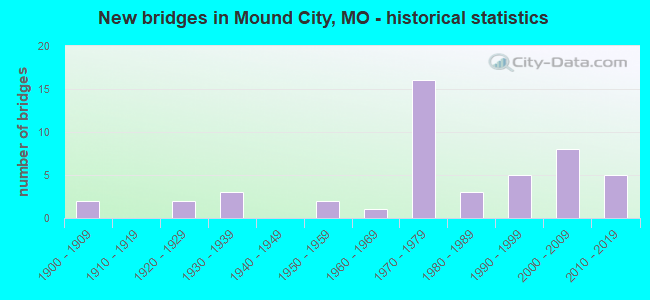
- New bridges - historical statistics
- 21900-1909
- 21920-1929
- 31930-1939
- 21950-1959
- 11960-1969
- 161970-1979
- 31980-1989
- 51990-1999
- 82000-2009
- 52010-2019

- Reconstructed bridges - Historical Statistics
- 12000-2009
- 22010-2019


- Bridge Condition - Deck
- 10.0%Excellent
- 6.7%Very good
- 46.7%Good
- 26.7%Satisfactory
- 6.7%Fair
- 3.3%Poor

- Bridge Condition - Superstructure
- 6.7%Excellent
- 13.3%Very good
- 30.0%Good
- 30.0%Satisfactory
- 20.0%Fair

- Bridge Condition - Substructure
- 6.7%Excellent
- 10.0%Very good
- 36.7%Good
- 23.3%Satisfactory
- 10.0%Fair
- 10.0%Poor
- 3.3%Serious

- Bridge Condition - Channel
- 18.9%Good
- 37.8%Satisfactory
- 29.7%Fair
- 13.5%Poor

- Bridge Condition - Culverts
- 27.3%Very good
- 36.4%Good
- 18.2%Satisfactory
- 18.2%Poor
Find on map >> Show street view
Structure Number: 33560-00132, Location: "SEC 30, T61N, R38W" (Lat: 40.070167, Lng: -95.234000), Route carried "on" structure: Federal lands road , Year Built: 1998, Status: Open, Structure Length: 2.50m (8.20ft), Average Daily Traffic: 35 (year 2021), Average Future Daily Traffic: 35 (year 2041), Design Load: HS 20, Features Intersected: DAVIS CREEK, Facility Carried by Structure: TOUR ROUTE
Minimum Vertical Clearance: 30.48m (100.00ft), Kilometerpoint: 0.805, Lanes on structure: 2, Owner: Bureau of Fish and Wildlife, Approaching Roadway Width: 4.9m (16.1ft), Material/Design: Wood or Timber, Design/Construction: Slab, Number Of Spans In Main Unit: 3, Length of Maximum Span: 14.0m (45.9ft), Curb-To-Curb Width: 6.2m (20.3ft), Out-to-Out Width: 6.8m (22.3ft)
Condition: Deck: Good, Superstructure: Good, Substructure: Good, Channel: Good, Operating Rating: 49.0 metric tons, Method Used To Determine Operating Rating: Allowable Stress (AS), Inventory Rating: 36.3 metric tons, Method Used To Determine Inventory Rating: Allowable Stress (AS), Structural Evaluation: Better than present minimum criteria, Deck Geometry: Somewhat better than minimum adequacy, Waterway Adequacy: Better than present minimum criteria, Approach Roadway Alignment: Somewhat better than minimum adequacy, Designated Inspection Frequency: Every 24 months, Inspection Date: August 2021, Deck Structure Type: Wood or Timber, Wearing Surface/Protective System: Wearing Surface: Bituminous
Find on map >> Show street view
Structure Number: 1462, Location: S 36 T 62 N R 39 W (Lat: 40.132728, Lng: -95.237897), Route carried "on" structure: State highway 118, Year Built: 1972, Status: Open, Structure Length: 6.58m (21.59ft), Average Daily Traffic: 2,029 (year 2021), Truck Traffic: 22%, Average Future Daily Traffic: 2,638 (year 2041), Design Load: H 20, Features Intersected: IS 29
Minimum Vertical Clearance: 30+ m (98+ ft), Kilometerpoint: 10.570, Lanes on structure: 2, Lanes under structure: 4, Owner: State Highway Agency, Approaching Roadway Width: 6.7m (22.0ft), Skew: 1 degrees, Material/Design: Steel continuous, Design/Construction: Stringer/Multi-beam, Number Of Spans In Main Unit: 4, Length of Maximum Span: 21.6m (70.9ft), Curb-To-Curb Width: 12.2m (40.0ft), Out-to-Out Width: 13.0m (42.7ft)
Condition: Deck: Poor, Superstructure: Satisfactory, Substructure: Satisfactory, Operating Rating: 38.7 metric tons, Method Used To Determine Operating Rating: Load Factor (LF), Inventory Rating: 23.4 metric tons, Method Used To Determine Inventory Rating: Load Factor (LF), Structural Evaluation: Equal to present minimum criteria, Deck Geometry: Equal to present minimum criteria, Underclear: Somewhat better than minimum adequacy, Approach Roadway Alignment: Equal to present desirable criteria, Designated Inspection Frequency: Every 24 months, Inspection Date: November 2021, Deck Structure Type: Concrete Cast-file-Place, Wearing Surface/Protective System: Wearing Surface: Monolithic Concrete, Deck Protection: Internally Sealed
Find on map >> Show street view
Structure Number: 1463, Location: S 6 T 61 N R 38 W (Lat: 40.128764, Lng: -95.236372), Route carried "on" structure: Interstate 29, Year Built: 1972, Status: Open, Structure Length: 4.79m (15.72ft), Average Daily Traffic: 9,082 (year 2021), Truck Traffic: 34%, Average Future Daily Traffic: 19,072 (year 2041), Design Load: HS 20+Mod, Features Intersected: DAVIS CR
Minimum Vertical Clearance: 30+ m (98+ ft), Kilometerpoint: 64.562, Lanes on structure: 3, Base Highway Network: Yes, Owner: State Highway Agency, Approaching Roadway Width: 12.2m (40.0ft), Material/Design: Steel continuous, Design/Construction: Stringer/Multi-beam, Number Of Spans In Main Unit: 3, Length of Maximum Span: 24.7m (81.0ft), Curb or Sidewalk Widths: Left: 0.4m (1.3ft), Right: 0.4m (1.3ft), Curb-To-Curb Width: 14.0m (45.9ft), Out-to-Out Width: 14.9m (48.9ft)
Condition: Deck: Good, Superstructure: Good, Substructure: Satisfactory, Channel: Satisfactory, Operating Rating: 45.9 metric tons, Method Used To Determine Operating Rating: Load Factor (LF), Inventory Rating: 27.9 metric tons, Method Used To Determine Inventory Rating: Load Factor (LF), Structural Evaluation: Equal to present minimum criteria, Deck Geometry: Meets minimum limits, Waterway Adequacy: Equal to present desirable criteria, Approach Roadway Alignment: Equal to present desirable criteria, Designated Inspection Frequency: Every 24 months, Inspection Date: November 2021, Deck Structure Type: Concrete Cast-file-Place, Wearing Surface/Protective System: Wearing Surface: Latex Concrete
Find on map >> Show street view
Structure Number: 1464, Location: S 6 T 61 N R 38 W (Lat: 40.128914, Lng: -95.236069), Route carried "on" structure: Interstate 29, Year Built: 1972, Status: Open, Structure Length: 4.79m (15.72ft), Average Daily Traffic: 7,863 (year 2021), Truck Traffic: 36%, Average Future Daily Traffic: 16,512 (year 2041), Design Load: HS 20, Features Intersected: DAVIS CR
Minimum Vertical Clearance: 30+ m (98+ ft), Kilometerpoint: 142.532, Lanes on structure: 3, Base Highway Network: Yes, Owner: State Highway Agency, Approaching Roadway Width: 12.2m (40.0ft), Skew: 1 degrees, Material/Design: Steel continuous, Design/Construction: Stringer/Multi-beam, Number Of Spans In Main Unit: 3, Length of Maximum Span: 24.7m (81.0ft), Curb or Sidewalk Widths: Left: 0.4m (1.3ft), Right: 0.4m (1.3ft), Curb-To-Curb Width: 14.0m (45.9ft), Out-to-Out Width: 14.9m (48.9ft)
Condition: Deck: Good, Superstructure: Satisfactory, Substructure: Satisfactory, Channel: Satisfactory, Operating Rating: 45.9 metric tons, Method Used To Determine Operating Rating: Load Factor (LF), Inventory Rating: 27.9 metric tons, Method Used To Determine Inventory Rating: Load Factor (LF), Structural Evaluation: Equal to present minimum criteria, Deck Geometry: Meets minimum limits, Waterway Adequacy: Equal to present desirable criteria, Approach Roadway Alignment: Equal to present desirable criteria, Designated Inspection Frequency: Every 24 months, Inspection Date: November 2021, Deck Structure Type: Concrete Cast-file-Place, Wearing Surface/Protective System: Wearing Surface: Latex Concrete
Find on map >> Show street view
Structure Number: 1467, Location: S 17 T 61 N R 38 W (Lat: 40.091269, Lng: -95.212861), Route carried "on" structure: Interstate 29, Year Built: 1972, Status: Open, Structure Length: 0.64m (2.10ft), Average Daily Traffic: 16,945 (year 2021), Truck Traffic: 34%, Average Future Daily Traffic: 35,585 (year 2041), Design Load: HS 20, Features Intersected: BLAIR CR
Minimum Vertical Clearance: 30+ m (98+ ft), Kilometerpoint: 69.488, Lanes on structure: 4, Base Highway Network: Yes, Owner: State Highway Agency, Approaching Roadway Width: 39.0m (128.0ft), Skew: 20 degrees, Material/Design: Concrete continuous, Design/Construction: Culvert, Number Of Spans In Main Unit: 2, Length of Maximum Span: 3.0m (9.8ft)
Condition: Channel: Fair, Culverts: Satisfactory, Operating Rating: 76.5 metric tons, Method Used To Determine Operating Rating: Load Factor (LF), Inventory Rating: 45.9 metric tons, Method Used To Determine Inventory Rating: Load Factor (LF), Structural Evaluation: Equal to present minimum criteria, Waterway Adequacy: Equal to present desirable criteria, Approach Roadway Alignment: Equal to present desirable criteria, Designated Inspection Frequency: Every 24 months, Inspection Date: January 2022
Find on map >> Show street view
Structure Number: 1468, Location: S 20 T 61 N R 38 W (Lat: 40.082828, Lng: -95.210556), Route carried "on" structure: Interstate 29, Year Built: 1972, Year Reconstructed: 2019, Status: Open, Structure Length: 4.18m (13.71ft), Average Daily Traffic: 9,082 (year 2021), Truck Traffic: 34%, Average Future Daily Traffic: 19,072 (year 2041), Design Load: HS 20, Features Intersected: RT E
Minimum Vertical Clearance: 30+ m (98+ ft), Kilometerpoint: 70.402, Lanes on structure: 2, Lanes under structure: 2, Base Highway Network: Yes, Owner: State Highway Agency, Approaching Roadway Width: 12.2m (40.0ft), Material/Design: Steel continuous, Design/Construction: Stringer/Multi-beam, Number Of Spans In Main Unit: 3, Length of Maximum Span: 17.4m (57.1ft), Curb-To-Curb Width: 11.6m (38.1ft), Out-to-Out Width: 12.4m (40.7ft)
Condition: Deck: Excellent, Superstructure: Good, Substructure: Satisfactory, Operating Rating: 45.9 metric tons, Method Used To Determine Operating Rating: Load Factor (LF), Inventory Rating: 27.9 metric tons, Method Used To Determine Inventory Rating: Load Factor (LF), Structural Evaluation: Equal to present minimum criteria, Deck Geometry: Equal to present minimum criteria, Underclear: Superior to present desirable criteria, Approach Roadway Alignment: Equal to present desirable criteria, Designated Inspection Frequency: Every 24 months, Inspection Date: November 2021, Deck Structure Type: Concrete Cast-file-Place, Wearing Surface/Protective System: Wearing Surface: Monolithic Concrete, Membrane: Other, Deck Protection: Other
Find on map >> Show street view
Structure Number: 1469, Location: S 20 T 61 N R 38 W (Lat: 40.083025, Lng: -95.210272), Route carried "on" structure: Interstate 29, Year Built: 1972, Year Reconstructed: 2019, Status: Open, Structure Length: 4.18m (13.71ft), Average Daily Traffic: 7,863 (year 2021), Truck Traffic: 36%, Average Future Daily Traffic: 16,512 (year 2041), Design Load: HS 20+Mod, Features Intersected: RT E
Minimum Vertical Clearance: 30+ m (98+ ft), Kilometerpoint: 136.720, Lanes on structure: 2, Lanes under structure: 2, Base Highway Network: Yes, Owner: State Highway Agency, Approaching Roadway Width: 12.2m (40.0ft), Material/Design: Steel continuous, Design/Construction: Stringer/Multi-beam, Number Of Spans In Main Unit: 3, Length of Maximum Span: 17.4m (57.1ft), Curb-To-Curb Width: 11.6m (38.1ft), Out-to-Out Width: 12.4m (40.7ft)
Condition: Deck: Excellent, Superstructure: Good, Substructure: Satisfactory, Operating Rating: 45.9 metric tons, Method Used To Determine Operating Rating: Load Factor (LF), Inventory Rating: 27.9 metric tons, Method Used To Determine Inventory Rating: Load Factor (LF), Structural Evaluation: Equal to present minimum criteria, Deck Geometry: Equal to present minimum criteria, Underclear: Superior to present desirable criteria, Approach Roadway Alignment: Equal to present desirable criteria, Designated Inspection Frequency: Every 24 months, Inspection Date: November 2021, Deck Structure Type: Concrete Cast-file-Place, Wearing Surface/Protective System: Wearing Surface: Monolithic Concrete, Membrane: Other, Deck Protection: Other
Find on map >> Show street view
Structure Number: 15618, Location: S 8 T 44 N R 5 E (Lat: 38.568067, Lng: -90.473231), Route carried "on" structure: County highway , Year Built: 1928, Status: Posted for load, Structure Length: 0.70m (2.30ft), Average Daily Traffic: 10,081 (year 2020), Truck Traffic: 10%, Average Future Daily Traffic: 13,609 (year 2040), Design Load: H 15, Features Intersected: BR OF GRAND GLAIZE, Facility Carried by Structure: BIG BEND BLVD
Minimum Vertical Clearance: 30+ m (98+ ft), Kilometerpoint: 0.000, Lanes on structure: 2, Owner: County Highway Agency, Approaching Roadway Width: 12.2m (40.0ft), Material/Design: Concrete continuous, Design/Construction: Slab, Number Of Spans In Main Unit: 1, Length of Maximum Span: 6.1m (20.0ft), Curb-To-Curb Width: 12.2m (40.0ft), Out-to-Out Width: 13.2m (43.3ft)
Condition: Deck: Fair, Superstructure: Fair, Substructure: Fair, Channel: Fair, Operating Rating: 31.5 metric tons, Method Used To Determine Operating Rating: Load Factor (LF), Inventory Rating: 18.9 metric tons, Method Used To Determine Inventory Rating: Load Factor (LF), Structural Evaluation: Meets minimum limits, Deck Geometry: Somewhat better than minimum adequacy, Waterway Adequacy: Equal to present minimum criteria, Approach Roadway Alignment: Equal to present desirable criteria, Designated Inspection Frequency: Every 24 months, Inspection Date: March 2020, Deck Structure Type: Concrete Cast-file-Place, Wearing Surface/Protective System: Wearing Surface: Bituminous
Find on map >> Show street view
Structure Number: 1604, Location: S 26 T 62 N R 39 W (Lat: 40.158811, Lng: -95.275733), Route carried "on" structure: County highway , Year Built: 1972, Status: Open, Structure Length: 8.26m (27.10ft), Average Daily Traffic: 54 (year 2021), Truck Traffic: 11%, Average Future Daily Traffic: 70 (year 2041), Design Load: HS 20, Features Intersected: IS 29, Facility Carried by Structure: IRON WOOD RD S
Minimum Vertical Clearance: 30+ m (98+ ft), Kilometerpoint: 0.060, Lanes on structure: 2, Lanes under structure: 4, Owner: State Highway Agency, Approaching Roadway Width: 6.1m (20.0ft), Skew: 1 degrees, Material/Design: Steel continuous, Design/Construction: Stringer/Multi-beam, Number Of Spans In Main Unit: 2, Number Of Approach Spans: 2, Length of Maximum Span: 29.0m (95.1ft), Curb-To-Curb Width: 8.5m (27.9ft), Out-to-Out Width: 9.4m (30.8ft)
Condition: Deck: Good, Superstructure: Good, Substructure: Good, Operating Rating: 30.6 metric tons, Method Used To Determine Operating Rating: Allowable Stress (AS), Inventory Rating: 18.0 metric tons, Method Used To Determine Inventory Rating: Allowable Stress (AS), Structural Evaluation: Somewhat better than minimum adequacy, Deck Geometry: Better than present minimum criteria, Underclear: Equal to present desirable criteria, Approach Roadway Alignment: Equal to present minimum criteria, Designated Inspection Frequency: Every 24 months, Other Special Inspection Frequency: Every 24 months, Inspection Date: Febuary 2021, Other Special Inspection Date: Febuary 2021, Deck Structure Type: Concrete Cast-file-Place, Wearing Surface/Protective System: Wearing Surface: Monolithic Concrete
Find on map >> Show street view
Structure Number: 1605, Location: S 26 T 62 N R 39 W (Lat: 40.155461, Lng: -95.264700), Route carried "on" structure: Interstate 29, Year Built: 1972, Status: Open, Structure Length: 8.02m (26.31ft), Average Daily Traffic: 7,837 (year 2021), Truck Traffic: 34%, Average Future Daily Traffic: 16,458 (year 2041), Design Load: HS 20+Mod, Features Intersected: SQUAW CR
Minimum Vertical Clearance: 30+ m (98+ ft), Kilometerpoint: 60.523, Lanes on structure: 2, Base Highway Network: Yes, Owner: State Highway Agency, Approaching Roadway Width: 11.6m (38.1ft), Material/Design: Steel continuous, Design/Construction: Stringer/Multi-beam, Number Of Spans In Main Unit: 3, Length of Maximum Span: 35.4m (116.1ft), Curb-To-Curb Width: 12.0m (39.4ft), Out-to-Out Width: 12.9m (42.3ft)
Condition: Deck: Satisfactory, Superstructure: Good, Substructure: Good, Channel: Satisfactory, Operating Rating: 51.3 metric tons, Method Used To Determine Operating Rating: Load Factor (LF), Inventory Rating: 30.6 metric tons, Method Used To Determine Inventory Rating: Load Factor (LF), Structural Evaluation: Better than present minimum criteria, Deck Geometry: Equal to present minimum criteria, Waterway Adequacy: Equal to present desirable criteria, Approach Roadway Alignment: Equal to present desirable criteria, Designated Inspection Frequency: Every 24 months, Inspection Date: November 2021, Deck Structure Type: Concrete Cast-file-Place, Wearing Surface/Protective System: Wearing Surface: Bituminous
Find on map >> Show street view
Structure Number: 1606, Location: S 26 T 62 N R 39 W (Lat: 40.155669, Lng: -95.264528), Route carried "on" structure: Interstate 29, Year Built: 1972, Status: Open, Structure Length: 8.02m (26.31ft), Average Daily Traffic: 7,908 (year 2021), Truck Traffic: 36%, Average Future Daily Traffic: 16,607 (year 2041), Design Load: HS 20+Mod, Features Intersected: SQUAW CR
Minimum Vertical Clearance: 30+ m (98+ ft), Kilometerpoint: 146.573, Lanes on structure: 2, Base Highway Network: Yes, Owner: State Highway Agency, Approaching Roadway Width: 11.6m (38.1ft), Material/Design: Steel continuous, Design/Construction: Stringer/Multi-beam, Number Of Spans In Main Unit: 3, Length of Maximum Span: 35.4m (116.1ft), Curb-To-Curb Width: 12.0m (39.4ft), Out-to-Out Width: 12.9m (42.3ft)
Condition: Deck: Satisfactory, Superstructure: Satisfactory, Substructure: Good, Channel: Satisfactory, Operating Rating: 51.3 metric tons, Method Used To Determine Operating Rating: Load Factor (LF), Inventory Rating: 30.6 metric tons, Method Used To Determine Inventory Rating: Load Factor (LF), Structural Evaluation: Equal to present minimum criteria, Deck Geometry: Equal to present minimum criteria, Waterway Adequacy: Equal to present desirable criteria, Approach Roadway Alignment: Equal to present desirable criteria, Designated Inspection Frequency: Every 24 months, Inspection Date: November 2021, Deck Structure Type: Concrete Cast-file-Place, Wearing Surface/Protective System: Wearing Surface: Bituminous
Find on map >> Show street view
Structure Number: 16096, Location: S 7 T 62 N R 38 W (Lat: 40.204244, Lng: -95.232611), Route carried "on" structure: County highway 110, Year Built: 1989, Status: Open, Structure Length: 4.05m (13.29ft), Average Daily Traffic: 35 (year 2021), Truck Traffic: 10%, Average Future Daily Traffic: 40 (year 2041), Features Intersected: MID BR OF SQAW CR, Facility Carried by Structure: COUNTY RD 140
Minimum Vertical Clearance: 30+ m (98+ ft), Kilometerpoint: 0.483, Lanes on structure: 2, Owner: County Highway Agency, Approaching Roadway Width: 7.3m (24.0ft), Skew: 4 degrees, Material/Design: Prestressed concrete continuous, Design/Construction: Tee Beam, Number Of Spans In Main Unit: 3, Length of Maximum Span: 15.2m (49.9ft), Curb-To-Curb Width: 7.3m (24.0ft), Out-to-Out Width: 8.1m (26.6ft)
Condition: Deck: Good, Superstructure: Satisfactory, Substructure: Satisfactory, Channel: Fair, Operating Rating: 49.5 metric tons, Method Used To Determine Operating Rating: Allowable Stress (AS), Inventory Rating: 32.4 metric tons, Method Used To Determine Inventory Rating: Allowable Stress (AS), Structural Evaluation: Equal to present minimum criteria, Deck Geometry: Equal to present minimum criteria, Waterway Adequacy: Equal to present desirable criteria, Approach Roadway Alignment: Equal to present desirable criteria, Designated Inspection Frequency: Every 24 months, Inspection Date: November 2021, Deck Structure Type: Concrete Cast-file-Place, Wearing Surface/Protective System: Wearing Surface: Monolithic Concrete
Find on map >> Show street view
Structure Number: 1613, Location: S 7 T 62 N R 38 W (Lat: 40.192978, Lng: -95.219794), Route carried "on" structure: County highway 111, Year Built: 1900, Status: Posted for load, Structure Length: 2.35m (7.71ft), Average Daily Traffic: 10 (year 2021), Truck Traffic: 10%, Average Future Daily Traffic: 12 (year 2041), Features Intersected: SQUAW CR, Facility Carried by Structure: LINCOLN RD
Minimum Vertical Clearance: 30+ m (98+ ft), Kilometerpoint: 1.127, Lanes on structure: 1, Owner: County Highway Agency, Approaching Roadway Width: 4.9m (16.1ft), Material/Design: Steel, Design/Construction: Truss - Thru, Number Of Spans In Main Unit: 1, Length of Maximum Span: 22.9m (75.1ft), Curb-To-Curb Width: 5.4m (17.7ft), Out-to-Out Width: 5.5m (18.0ft)
Condition: Deck: Good, Superstructure: Fair, Substructure: Serious, Channel: Poor, Operating Rating: 7.2 metric tons, Method Used To Determine Operating Rating: Allowable Stress (AS), Inventory Rating: 4.5 metric tons, Method Used To Determine Inventory Rating: Allowable Stress (AS), Structural Evaluation: High priority of replacement, Deck Geometry: High priority of corrective action, Waterway Adequacy: Equal to present desirable criteria, Approach Roadway Alignment: Equal to present desirable criteria, Bridge Posting: Required (Relationship of Operating Rating to Maximum Legal Load: > 39.9% below), Length Of Structure Improvement: 0.32m (1.05ft), Designated Inspection Frequency: Every 24 months, Critical Feature Inspection Frequency: Every 24 months, Inspection Date: November 2021, Critical Feature Inspection Date: January 2022, Bridge Improvement Cost: $233,000, Roadway Improvement Cost: $23,000, Total Project Cost: $350,000 ( Estimate for 2022), Deck Structure Type: Wood or Timber
Find on map >> Show street view
Structure Number: 16235, Location: S 16 T 62 N R 38 W (Lat: 40.181597, Lng: -95.181922), Route carried "on" structure: County highway 114, Year Built: 1930, Status: Posted for load, Structure Length: 1.22m (4.00ft), Average Daily Traffic: 15 (year 2021), Truck Traffic: 10%, Average Future Daily Traffic: 17 (year 2041), Features Intersected: DAVIS CR, Facility Carried by Structure: NOVEMBER RD
Minimum Vertical Clearance: 30+ m (98+ ft), Kilometerpoint: 2.253, Lanes on structure: 1, Owner: County Highway Agency, Approaching Roadway Width: 4.9m (16.1ft), Material/Design: Steel, Design/Construction: Girder and Floorbeam System, Number Of Spans In Main Unit: 1, Length of Maximum Span: 11.9m (39.0ft), Curb-To-Curb Width: 4.7m (15.4ft), Out-to-Out Width: 4.7m (15.4ft)
Condition: Deck: Good, Superstructure: Satisfactory, Substructure: Poor, Channel: Fair, Operating Rating: 14.4 metric tons, Method Used To Determine Operating Rating: Load Factor (LF), Inventory Rating: 9.0 metric tons, Method Used To Determine Inventory Rating: Load Factor (LF), Structural Evaluation: High priority of replacement, Deck Geometry: Better than present minimum criteria, Waterway Adequacy: Meets minimum limits, Approach Roadway Alignment: Equal to present minimum criteria, Bridge Posting: Required (Relationship of Operating Rating to Maximum Legal Load: > 39.9% below), Length Of Structure Improvement: 0.19m (0.62ft), Designated Inspection Frequency: Every 24 months, Critical Feature Inspection Frequency: Every 24 months, Inspection Date: November 2021, Critical Feature Inspection Date: November 2021, Bridge Improvement Cost: $138,000, Roadway Improvement Cost: $14,000, Total Project Cost: $206,000 ( Estimate for 2022), Deck Structure Type: Wood or Timber
Find on map >> Show street view
Structure Number: 1642, Location: S 29 T 62 N R 38 W (Lat: 40.145567, Lng: -95.207839), Route carried "on" structure: County highway 119, Year Built: 1997, Status: Open, Structure Length: 2.13m (6.99ft), Average Daily Traffic: 40 (year 2021), Truck Traffic: 10%, Average Future Daily Traffic: 46 (year 2041), Features Intersected: DAVIS CR, Facility Carried by Structure: COUNTY RD 180
Minimum Vertical Clearance: 30+ m (98+ ft), Kilometerpoint: 1.609, Lanes on structure: 2, Owner: County Highway Agency, Approaching Roadway Width: 6.1m (20.0ft), Material/Design: Steel, Design/Construction: Stringer/Multi-beam, Number Of Spans In Main Unit: 1, Length of Maximum Span: 21.3m (69.9ft), Curb-To-Curb Width: 6.8m (22.3ft), Out-to-Out Width: 6.9m (22.6ft)
Condition: Deck: Good, Superstructure: Good, Substructure: Satisfactory, Channel: Fair, Operating Rating: 45.0 metric tons, Method Used To Determine Operating Rating: Load Factor (LF), Inventory Rating: 27.0 metric tons, Method Used To Determine Inventory Rating: Load Factor (LF), Structural Evaluation: Equal to present minimum criteria, Deck Geometry: Somewhat better than minimum adequacy, Waterway Adequacy: Equal to present desirable criteria, Approach Roadway Alignment: Equal to present desirable criteria, Designated Inspection Frequency: Every 24 months, Inspection Date: November 2021, Deck Structure Type: Concrete Cast-file-Place, Wearing Surface/Protective System: Wearing Surface: Monolithic Concrete
Find on map >> Show street view
Structure Number: 16448, Location: S 1 T 59 N R 31 W (Lat: 39.952653, Lng: -94.337106), Route carried "on" structure: County highway 120, Year Built: 1988, Year Reconstructed: 2011, Status: Open, Structure Length: 2.13m (6.99ft), Average Daily Traffic: 10 (year 2021), Truck Traffic: 10%, Average Future Daily Traffic: 12 (year 2041), Features Intersected: M FK LOST CR, Facility Carried by Structure: NE BAKER RD
Minimum Vertical Clearance: 30+ m (98+ ft), Kilometerpoint: 3.219, Lanes on structure: 2, Owner: County Highway Agency, Approaching Roadway Width: 4.9m (16.1ft), Material/Design: Steel, Design/Construction: Stringer/Multi-beam, Number Of Spans In Main Unit: 1, Length of Maximum Span: 20.8m (68.2ft), Curb-To-Curb Width: 5.9m (19.4ft), Out-to-Out Width: 6.1m (20.0ft)
Condition: Deck: Very good, Superstructure: Fair, Substructure: Good, Channel: Fair, Operating Rating: 37.8 metric tons, Method Used To Determine Operating Rating: Load Factor (LF), Inventory Rating: 22.5 metric tons, Method Used To Determine Inventory Rating: Load Factor (LF), Structural Evaluation: Somewhat better than minimum adequacy, Deck Geometry: Meets minimum limits, Waterway Adequacy: Equal to present minimum criteria, Approach Roadway Alignment: Equal to present minimum criteria, Designated Inspection Frequency: Every 24 months, Inspection Date: Febuary 2021, Deck Structure Type: Concrete Cast-file-Place
Find on map >> Show street view
Structure Number: 16594, Location: S 13 T 62 N R 39 W (Lat: 40.175433, Lng: -95.257231), Route carried "on" structure: County highway 126, Year Built: 1996, Status: Open, Structure Length: 3.96m (12.99ft), Average Daily Traffic: 30 (year 2021), Truck Traffic: 10%, Average Future Daily Traffic: 35 (year 2041), Design Load: HS 20, Features Intersected: SQUAW CR, Facility Carried by Structure: COUNTY RD 160
Minimum Vertical Clearance: 30+ m (98+ ft), Kilometerpoint: 0.805, Lanes on structure: 2, Owner: County Highway Agency, Approaching Roadway Width: 5.5m (18.0ft), Skew: 2 degrees, Material/Design: Prestressed concrete, Design/Construction: Tee Beam, Number Of Spans In Main Unit: 3, Length of Maximum Span: 13.1m (43.0ft), Curb-To-Curb Width: 7.3m (24.0ft), Out-to-Out Width: 8.1m (26.6ft)
Condition: Deck: Satisfactory, Superstructure: Good, Substructure: Good, Channel: Satisfactory, Operating Rating: 68.4 metric tons, Method Used To Determine Operating Rating: Load Factor (LF), Inventory Rating: 37.8 metric tons, Method Used To Determine Inventory Rating: Load Factor (LF), Structural Evaluation: Better than present minimum criteria, Deck Geometry: Equal to present minimum criteria, Waterway Adequacy: Equal to present desirable criteria, Approach Roadway Alignment: Equal to present minimum criteria, Designated Inspection Frequency: Every 24 months, Inspection Date: November 2021, Deck Structure Type: Concrete Cast-file-Place, Wearing Surface/Protective System: Wearing Surface: Monolithic Concrete
Find on map >> Show street view
Structure Number: 16652, Location: S 1 T 62 N R 39 W (Lat: 40.204600, Lng: -95.251111), Route carried "on" structure: County highway 128, Year Built: 1930, Status: Posted for load, Structure Length: 2.99m (9.81ft), Average Daily Traffic: 10 (year 2021), Truck Traffic: 10%, Average Future Daily Traffic: 12 (year 2041), Features Intersected: MINNESOTO VALLEY C, Facility Carried by Structure: COUNTY RD 140
Minimum Vertical Clearance: 30+ m (98+ ft), Kilometerpoint: 0.483, Lanes on structure: 1, Owner: County Highway Agency, Approaching Roadway Width: 4.3m (14.1ft), Material/Design: Steel, Design/Construction: Truss - Thru, Number Of Spans In Main Unit: 1, Number Of Approach Spans: 1, Length of Maximum Span: 24.4m (80.1ft), Curb-To-Curb Width: 4.3m (14.1ft), Out-to-Out Width: 4.3m (14.1ft)
Condition: Deck: Satisfactory, Superstructure: Fair, Substructure: Poor, Channel: Poor, Operating Rating: 6.3 metric tons, Method Used To Determine Operating Rating: Allowable Stress (AS), Inventory Rating: 3.6 metric tons, Method Used To Determine Inventory Rating: Allowable Stress (AS), Structural Evaluation: High priority of replacement, Deck Geometry: Equal to present minimum criteria, Waterway Adequacy: Equal to present desirable criteria, Approach Roadway Alignment: Equal to present minimum criteria, Bridge Posting: Required (Relationship of Operating Rating to Maximum Legal Load: > 39.9% below), Length Of Structure Improvement: 0.39m (1.28ft), Designated Inspection Frequency: Every 24 months, Critical Feature Inspection Frequency: Every 24 months, Inspection Date: November 2021, Critical Feature Inspection Date: January 2022, Bridge Improvement Cost: $284,000, Roadway Improvement Cost: $28,000, Total Project Cost: $426,000 ( Estimate for 2022), Deck Structure Type: Wood or Timber
Find on map >> Show street view
Structure Number: 16771, Location: S 23 T 61 N R 38 W (Lat: 40.167306, Lng: -95.267006), Route carried "on" structure: County highway 131, Year Built: 1999, Status: Open, Structure Length: 3.75m (12.30ft), Average Daily Traffic: 25 (year 2021), Truck Traffic: 10%, Average Future Daily Traffic: 29 (year 2041), Design Load: HS 20, Features Intersected: WILDCAT CR, Facility Carried by Structure: INDIAN RD
Minimum Vertical Clearance: 30+ m (98+ ft), Kilometerpoint: 4.345, Lanes on structure: 2, Owner: County Highway Agency, Approaching Roadway Width: 5.5m (18.0ft), Skew: 4 degrees, Material/Design: Prestressed concrete, Design/Construction: Stringer/Multi-beam, Number Of Spans In Main Unit: 3, Length of Maximum Span: 12.2m (40.0ft), Curb-To-Curb Width: 7.3m (24.0ft), Out-to-Out Width: 8.1m (26.6ft)
Condition: Deck: Good, Superstructure: Satisfactory, Substructure: Good, Channel: Satisfactory, Operating Rating: 88.2 metric tons, Method Used To Determine Operating Rating: Allowable Stress (AS), Inventory Rating: 53.1 metric tons, Method Used To Determine Inventory Rating: Allowable Stress (AS), Structural Evaluation: Equal to present minimum criteria, Deck Geometry: Equal to present minimum criteria, Waterway Adequacy: Superior to present desirable criteria, Approach Roadway Alignment: Equal to present desirable criteria, Designated Inspection Frequency: Every 24 months, Inspection Date: November 2021, Deck Structure Type: Concrete Cast-file-Place
Find on map >> Show street view
Structure Number: 16824, Location: S 15 T 62 N R 39 W (Lat: 40.175861, Lng: -95.276400), Route carried "on" structure: County highway 133, Year Built: 1900, Status: Posted for load, Structure Length: 2.77m (9.09ft), Average Daily Traffic: 25 (year 2021), Truck Traffic: 10%, Average Future Daily Traffic: 29 (year 2041), Features Intersected: WILDCAT CR, Facility Carried by Structure: IRONWOOD RD
Minimum Vertical Clearance: 30+ m (98+ ft), Kilometerpoint: 4.667, Lanes on structure: 1, Owner: County Highway Agency, Approaching Roadway Width: 4.6m (15.1ft), Material/Design: Steel, Design/Construction: Truss - Thru, Number Of Spans In Main Unit: 1, Number Of Approach Spans: 2, Length of Maximum Span: 15.5m (50.9ft), Curb-To-Curb Width: 4.2m (13.8ft), Out-to-Out Width: 4.3m (14.1ft)
Condition: Deck: Satisfactory, Superstructure: Fair, Substructure: Poor, Channel: Poor, Operating Rating: 9.0 metric tons, Method Used To Determine Operating Rating: Allowable Stress (AS), Inventory Rating: 5.4 metric tons, Method Used To Determine Inventory Rating: Allowable Stress (AS), Structural Evaluation: High priority of replacement, Deck Geometry: Somewhat better than minimum adequacy, Waterway Adequacy: Somewhat better than minimum adequacy, Approach Roadway Alignment: Equal to present desirable criteria, Bridge Posting: Required (Relationship of Operating Rating to Maximum Legal Load: > 39.9% below), Length Of Structure Improvement: 0.37m (1.21ft), Designated Inspection Frequency: Every 24 months, Critical Feature Inspection Frequency: Every 24 months, Inspection Date: November 2021, Critical Feature Inspection Date: January 2022, Bridge Improvement Cost: $269,000, Roadway Improvement Cost: $27,000, Total Project Cost: $403,000 ( Estimate for 2022), Deck Structure Type: Wood or Timber
Find on map >> Show street view
Structure Number: 17284, Location: S 35 T 47 N R 21 W (Lat: 38.807378, Lng: -93.201450), Route carried "on" structure: County highway 147, Year Built: 1997, Status: Open, Structure Length: 4.94m (16.21ft), Average Daily Traffic: 50 (year 2020), Truck Traffic: 10%, Average Future Daily Traffic: 85 (year 2040), Design Load: HS 20, Features Intersected: MUDDY CR, Facility Carried by Structure: FRISTO RD
Minimum Vertical Clearance: 30+ m (98+ ft), Kilometerpoint: 2.092, Lanes on structure: 2, Owner: County Highway Agency, Approaching Roadway Width: 8.5m (27.9ft), Skew: 1 degrees, Material/Design: Prestressed concrete, Design/Construction: Stringer/Multi-beam, Number Of Spans In Main Unit: 3, Length of Maximum Span: 21.0m (68.9ft), Curb-To-Curb Width: 7.3m (24.0ft), Out-to-Out Width: 8.0m (26.2ft)
Condition: Deck: Good, Superstructure: Very good, Substructure: Very good, Channel: Satisfactory, Operating Rating: 72.9 metric tons, Method Used To Determine Operating Rating: Load Factor (LF), Inventory Rating: 36.9 metric tons, Method Used To Determine Inventory Rating: Load Factor (LF), Structural Evaluation: Equal to present desirable criteria, Deck Geometry: Equal to present minimum criteria, Waterway Adequacy: Equal to present minimum criteria, Approach Roadway Alignment: Equal to present desirable criteria, Designated Inspection Frequency: Every 24 months, Inspection Date: Febuary 2022, Deck Structure Type: Concrete Cast-file-Place, Wearing Surface/Protective System: Wearing Surface: Monolithic Concrete
Find on map >> Show street view
Structure Number: 20466, Location: S 18 T 65 N R 10 W (Lat: 40.441861, Lng: -92.045556), Route carried "on" structure: County highway 261, Year Built: 1989, Status: Open, Structure Length: 0.76m (2.49ft), Average Daily Traffic: 50 (year 2019), Truck Traffic: 10%, Average Future Daily Traffic: 63 (year 2039), Features Intersected: ALLEN CR, Facility Carried by Structure: COUNTY ROAD 455
Minimum Vertical Clearance: 30+ m (98+ ft), Kilometerpoint: 1.448, Lanes on structure: 2, Owner: County Highway Agency, Approaching Roadway Width: 7.3m (24.0ft), Material/Design: Steel, Design/Construction: Stringer/Multi-beam, Number Of Spans In Main Unit: 1, Length of Maximum Span: 6.7m (22.0ft), Curb-To-Curb Width: 5.8m (19.0ft), Out-to-Out Width: 6.0m (19.7ft)
Condition: Deck: Satisfactory, Superstructure: Satisfactory, Substructure: Fair, Channel: Fair, Operating Rating: 62.1 metric tons, Method Used To Determine Operating Rating: Allowable Stress (AS), Inventory Rating: 36.9 metric tons, Method Used To Determine Inventory Rating: Allowable Stress (AS), Structural Evaluation: Somewhat better than minimum adequacy, Deck Geometry: Meets minimum limits, Waterway Adequacy: Somewhat better than minimum adequacy, Approach Roadway Alignment: Equal to present desirable criteria, Designated Inspection Frequency: Every 24 months, Inspection Date: June 2021, Deck Structure Type: Concrete Cast-file-Place
Find on map >> Show street view
Structure Number: 21199, Location: S 6 T 62 N R 38 W (Lat: 40.129864, Lng: -95.231186), Route carried "on" structure: City street , Year Built: 1938, Status: Closed, Structure Length: 2.38m (7.81ft), Average Daily Traffic: 1,000 (year 2021), Truck Traffic: 10%, Average Future Daily Traffic: 1,150 (year 2041), Features Intersected: DAVIS CR, Facility Carried by Structure: STATE ST
Minimum Vertical Clearance: 30+ m (98+ ft), Kilometerpoint: 0.161, Lanes on structure: 2, Owner: County Highway Agency, Maintenance Responsibility: City or Municipal Highway Agency, Approaching Roadway Width: 7.3m (24.0ft), Skew: 2 degrees, Material/Design: Concrete continuous, Design/Construction: Stringer/Multi-beam, Number Of Spans In Main Unit: 3, Length of Maximum Span: 13.8m (45.3ft), Curb-To-Curb Width: 7.3m (24.0ft), Out-to-Out Width: 9.8m (32.2ft)
Condition: Deck: Fair, Superstructure: Fair, Substructure: Fair, Channel: Fair, Deck Geometry: Meets minimum limits, Waterway Adequacy: Equal to present minimum criteria, Approach Roadway Alignment: Equal to present minimum criteria, Bridge Posting: Required (Relationship of Operating Rating to Maximum Legal Load: > 39.9% below), Length Of Structure Improvement: 0.32m (1.05ft), Designated Inspection Frequency: Every 24 months, Inspection Date: November 2021, Bridge Improvement Cost: $403,000, Roadway Improvement Cost: $40,000, Total Project Cost: $605,000 ( Estimate for 2022), Deck Structure Type: Concrete Cast-file-Place, Wearing Surface/Protective System: Wearing Surface: Bituminous
Find on map >> Show street view
Structure Number: 2221, Location: S 26 T 62 N R 39 W (Lat: 40.155917, Lng: -95.264303), Route carried "on" structure: US 59, Year Built: 1972, Status: Open, Structure Length: 8.02m (26.31ft), Average Daily Traffic: 883 (year 2021), Truck Traffic: 8%, Average Future Daily Traffic: 1,148 (year 2041), Design Load: H 15, Features Intersected: SQUAW CR
Minimum Vertical Clearance: 30+ m (98+ ft), Kilometerpoint: 56.446, Lanes on structure: 2, Owner: State Highway Agency, Approaching Roadway Width: 7.3m (24.0ft), Material/Design: Steel continuous, Design/Construction: Stringer/Multi-beam, Number Of Spans In Main Unit: 3, Length of Maximum Span: 35.4m (116.1ft), Curb-To-Curb Width: 7.3m (24.0ft), Out-to-Out Width: 8.2m (26.9ft)
Condition: Deck: Good, Superstructure: Good, Substructure: Very good, Channel: Satisfactory, Operating Rating: 36.0 metric tons, Method Used To Determine Operating Rating: Load Factor (LF), Inventory Rating: 21.6 metric tons, Method Used To Determine Inventory Rating: Load Factor (LF), Structural Evaluation: Somewhat better than minimum adequacy, Deck Geometry: Meets minimum limits, Waterway Adequacy: Equal to present desirable criteria, Approach Roadway Alignment: Equal to present desirable criteria, Designated Inspection Frequency: Every 24 months, Inspection Date: November 2021, Deck Structure Type: Concrete Cast-file-Place, Wearing Surface/Protective System: Wearing Surface: Monolithic Concrete, Deck Protection: Epoxy Coated Reinforcing
Find on map >> Show street view
Structure Number: 2924, Location: S 22 T 62 N R 38 W (Lat: 40.165639, Lng: -95.182056), Route carried "on" structure: County highway 116, Year Built: 2002, Status: Open, Structure Length: 0.72m (2.36ft), Average Daily Traffic: 30 (year 2021), Truck Traffic: 10%, Average Future Daily Traffic: 35 (year 2041), Features Intersected: TRIB TO DAVIS CR, Facility Carried by Structure: NOVEMBER RD
Minimum Vertical Clearance: 30+ m (98+ ft), Kilometerpoint: 0.000, Lanes on structure: 2, Owner: County Highway Agency, Approaching Roadway Width: 6.7m (22.0ft), Material/Design: Steel, Design/Construction: Culvert, Number Of Spans In Main Unit: 2, Length of Maximum Span: 2.9m (9.5ft)
Condition: Channel: Fair, Culverts: Good, Structural Evaluation: Better than present minimum criteria, Waterway Adequacy: Equal to present minimum criteria, Approach Roadway Alignment: Equal to present desirable criteria, Designated Inspection Frequency: Every 24 months, Inspection Date: November 2021
Find on map >> Show street view
Structure Number: 30105, Location: S 2 T 61 N R 39 W (Lat: 40.120750, Lng: -95.259861), Route carried "on" structure: State highway 118, Year Built: 2003, Status: Open, Structure Length: 0.94m (3.08ft), Average Daily Traffic: 708 (year 2021), Truck Traffic: 22%, Average Future Daily Traffic: 920 (year 2041), Design Load: HS 20, Features Intersected: TODD DRAIN DTCH
Minimum Vertical Clearance: 30+ m (98+ ft), Kilometerpoint: 8.193, Lanes on structure: 2, Owner: State Highway Agency, Approaching Roadway Width: 11.0m (36.1ft), Material/Design: Concrete continuous, Design/Construction: Culvert, Number Of Spans In Main Unit: 2, Length of Maximum Span: 4.3m (14.1ft), Curb-To-Curb Width: 11.0m (36.1ft), Out-to-Out Width: 11.8m (38.7ft)
Condition: Channel: Good, Culverts: Good, Structural Evaluation: Better than present minimum criteria, Deck Geometry: Better than present minimum criteria, Waterway Adequacy: Superior to present desirable criteria, Approach Roadway Alignment: Equal to present desirable criteria, Designated Inspection Frequency: Every 24 months, Inspection Date: January 2022, Deck Structure Type: Concrete Cast-file-Place, Wearing Surface/Protective System: Wearing Surface: Monolithic Concrete, Deck Protection: Epoxy Coated Reinforcing
Find on map >> Show street view
Structure Number: 30106, Location: S 2 T 61 N R 39 W (Lat: 40.121083, Lng: -95.259478), Route carried "on" structure: State highway 118, Year Built: 2003, Status: Open, Structure Length: 1.04m (3.41ft), Average Daily Traffic: 708 (year 2021), Truck Traffic: 22%, Average Future Daily Traffic: 920 (year 2041), Design Load: HS 20, Features Intersected: TODD DRAIN DTCH
Minimum Vertical Clearance: 30+ m (98+ ft), Kilometerpoint: 8.330, Lanes on structure: 2, Owner: State Highway Agency, Approaching Roadway Width: 11.0m (36.1ft), Skew: 3 degrees, Material/Design: Concrete continuous, Design/Construction: Culvert, Number Of Spans In Main Unit: 2, Length of Maximum Span: 3.7m (12.1ft), Curb-To-Curb Width: 11.0m (36.1ft), Out-to-Out Width: 11.8m (38.7ft)
Condition: Channel: Good, Culverts: Very good, Structural Evaluation: Equal to present desirable criteria, Deck Geometry: Better than present minimum criteria, Waterway Adequacy: Superior to present desirable criteria, Approach Roadway Alignment: Equal to present desirable criteria, Designated Inspection Frequency: Every 24 months, Inspection Date: January 2022, Deck Structure Type: Concrete Cast-file-Place, Wearing Surface/Protective System: Wearing Surface: Monolithic Concrete, Deck Protection: Epoxy Coated Reinforcing
Find on map >> Show street view
Structure Number: 30107, Location: S 1 T 61 N R 39 W (Lat: 40.121500, Lng: -95.258706), Route carried "on" structure: State highway 118, Year Built: 2003, Status: Open, Structure Length: 1.51m (4.95ft), Average Daily Traffic: 708 (year 2021), Truck Traffic: 22%, Average Future Daily Traffic: 920 (year 2041), Design Load: HS 20, Features Intersected: TODD DRAIN DTCH
Minimum Vertical Clearance: 30+ m (98+ ft), Kilometerpoint: 8.407, Lanes on structure: 2, Owner: State Highway Agency, Approaching Roadway Width: 11.0m (36.1ft), Skew: 4 degrees, Material/Design: Concrete continuous, Design/Construction: Culvert, Number Of Spans In Main Unit: 3, Length of Maximum Span: 3.4m (11.2ft), Curb-To-Curb Width: 11.0m (36.1ft), Out-to-Out Width: 11.8m (38.7ft)
Condition: Channel: Good, Culverts: Good, Structural Evaluation: Better than present minimum criteria, Deck Geometry: Better than present minimum criteria, Waterway Adequacy: Superior to present desirable criteria, Approach Roadway Alignment: Equal to present desirable criteria, Designated Inspection Frequency: Every 24 months, Inspection Date: January 2022, Deck Structure Type: Concrete Cast-file-Place, Wearing Surface/Protective System: Wearing Surface: Monolithic Concrete, Deck Protection: Epoxy Coated Reinforcing
Find on map >> Show street view
Structure Number: 30108, Location: S 1 T 61 N R 39 W (Lat: 40.122369, Lng: -95.257103), Route carried "on" structure: State highway 118, Year Built: 2003, Status: Open, Structure Length: 0.87m (2.85ft), Average Daily Traffic: 708 (year 2021), Truck Traffic: 22%, Average Future Daily Traffic: 920 (year 2041), Design Load: HS 20, Features Intersected: TODD DRAIN DTCH
Minimum Vertical Clearance: 30+ m (98+ ft), Kilometerpoint: 8.578, Lanes on structure: 2, Owner: State Highway Agency, Approaching Roadway Width: 11.0m (36.1ft), Material/Design: Concrete continuous, Design/Construction: Culvert, Number Of Spans In Main Unit: 2, Length of Maximum Span: 3.7m (12.1ft), Curb-To-Curb Width: 11.0m (36.1ft), Out-to-Out Width: 11.8m (38.7ft)
Condition: Channel: Good, Culverts: Very good, Structural Evaluation: Equal to present desirable criteria, Deck Geometry: Better than present minimum criteria, Waterway Adequacy: Superior to present desirable criteria, Approach Roadway Alignment: Equal to present desirable criteria, Designated Inspection Frequency: Every 24 months, Inspection Date: January 2022, Deck Structure Type: Concrete Cast-file-Place, Wearing Surface/Protective System: Wearing Surface: Monolithic Concrete, Deck Protection: Epoxy Coated Reinforcing
Find on map >> Show street view
Structure Number: 30748, Location: S 5 T 62 N R 38 W (Lat: 40.203678, Lng: -95.208161), Route carried "on" structure: County highway 110, Year Built: 2003, Status: Open, Structure Length: 2.77m (9.09ft), Average Daily Traffic: 35 (year 2021), Truck Traffic: 10%, Average Future Daily Traffic: 40 (year 2041), Design Load: HS 20, Features Intersected: E BR SQUAW CR, Facility Carried by Structure: COUNTY RD 140
Minimum Vertical Clearance: 30+ m (98+ ft), Kilometerpoint: 2.575, Lanes on structure: 2, Owner: County Highway Agency, Approaching Roadway Width: 7.3m (24.0ft), Skew: 2 degrees, Material/Design: Prestressed concrete continuous, Design/Construction: Stringer/Multi-beam, Number Of Spans In Main Unit: 3, Length of Maximum Span: 9.1m (29.9ft), Curb-To-Curb Width: 7.3m (24.0ft), Out-to-Out Width: 8.1m (26.6ft)
Condition: Deck: Good, Superstructure: Very good, Substructure: Good, Channel: Fair, Inventory Rating: 67.5 metric tons, Method Used To Determine Inventory Rating: Load Factor (LF), Structural Evaluation: Better than present minimum criteria, Deck Geometry: Equal to present minimum criteria, Waterway Adequacy: Superior to present desirable criteria, Approach Roadway Alignment: Equal to present desirable criteria, Designated Inspection Frequency: Every 24 months, Inspection Date: November 2021, Deck Structure Type: Concrete Precast Panels
Find on map >> Show street view
Structure Number: 30839, Location: S 17 T 62 N R 38 W (Lat: 40.181128, Lng: -95.219733), Route carried "on" structure: County highway 111, Year Built: 2005, Status: Open, Structure Length: 0.61m (2.00ft), Average Daily Traffic: 10 (year 2021), Truck Traffic: 10%, Average Future Daily Traffic: 12 (year 2041), Design Load: HS 20, Features Intersected: TRIB E BR SQUAW CR, Facility Carried by Structure: LINCOLN RD
Minimum Vertical Clearance: 30+ m (98+ ft), Kilometerpoint: 2.575, Lanes on structure: 2, Owner: County Highway Agency, Approaching Roadway Width: 6.7m (22.0ft), Material/Design: Steel, Design/Construction: Culvert, Number Of Spans In Main Unit: 1, Length of Maximum Span: 6.1m (20.0ft)
Condition: Channel: Satisfactory, Culverts: Very good, Structural Evaluation: Equal to present desirable criteria, Waterway Adequacy: Superior to present desirable criteria, Approach Roadway Alignment: Equal to present desirable criteria, Designated Inspection Frequency: Every 24 months, Inspection Date: November 2021
Find on map >> Show street view
Structure Number: 32142, Location: S 4 T 61 N R 38 W (Lat: 40.127333, Lng: -95.191911), Route carried "on" structure: County highway 225, Year Built: 2007, Status: Open, Structure Length: 3.38m (11.09ft), Average Daily Traffic: 35 (year 2021), Truck Traffic: 10%, Average Future Daily Traffic: 40 (year 2041), Design Load: HS 20, Features Intersected: E FK OF DAVIS CR, Facility Carried by Structure: NICKLE RD
Minimum Vertical Clearance: 30+ m (98+ ft), Kilometerpoint: 0.322, Lanes on structure: 2, Owner: County Highway Agency, Approaching Roadway Width: 5.5m (18.0ft), Material/Design: Prestressed concrete continuous, Design/Construction: Stringer/Multi-beam, Number Of Spans In Main Unit: 3, Length of Maximum Span: 12.8m (42.0ft), Curb-To-Curb Width: 7.3m (24.0ft), Out-to-Out Width: 8.1m (26.6ft)
Condition: Deck: Good, Superstructure: Very good, Substructure: Good, Channel: Satisfactory, Operating Rating: 87.3 metric tons, Method Used To Determine Operating Rating: Load Factor (LF), Inventory Rating: 49.5 metric tons, Method Used To Determine Inventory Rating: Load Factor (LF), Structural Evaluation: Better than present minimum criteria, Deck Geometry: Equal to present minimum criteria, Waterway Adequacy: Superior to present desirable criteria, Approach Roadway Alignment: Equal to present desirable criteria, Designated Inspection Frequency: Every 24 months, Inspection Date: November 2021, Deck Structure Type: Concrete Precast Panels, Wearing Surface/Protective System: Wearing Surface: Monolithic Concrete
Find on map >> Show street view
Structure Number: 33351, Location: S 13 T 62 N R 38 W (Lat: 40.182083, Lng: -95.238714), Route carried "on" structure: State highway N, Year Built: 2011, Status: Open, Structure Length: 3.24m (10.63ft), Average Daily Traffic: 483 (year 2021), Truck Traffic: 11%, Average Future Daily Traffic: 628 (year 2041), Design Load: HS 20, Features Intersected: E BR SQUAW CR
Minimum Vertical Clearance: 30+ m (98+ ft), Kilometerpoint: 31.519, Lanes on structure: 2, Owner: State Highway Agency, Approaching Roadway Width: 7.3m (24.0ft), Skew: 2 degrees, Material/Design: Prestressed concrete, Design/Construction: Box Beam or Girders - Multiple, Number Of Spans In Main Unit: 1, Length of Maximum Span: 32.0m (105.0ft), Curb-To-Curb Width: 7.3m (24.0ft), Out-to-Out Width: 7.3m (24.0ft)
Condition: Deck: Satisfactory, Superstructure: Satisfactory, Substructure: Good, Channel: Satisfactory, Operating Rating: 68.4 metric tons, Method Used To Determine Operating Rating: Load Factor (LF), Inventory Rating: 30.6 metric tons, Method Used To Determine Inventory Rating: Load Factor (LF), Structural Evaluation: Equal to present minimum criteria, Deck Geometry: Meets minimum limits, Waterway Adequacy: Superior to present desirable criteria, Approach Roadway Alignment: Equal to present desirable criteria, Designated Inspection Frequency: Every 24 months, Inspection Date: November 2021, Deck Structure Type: Concrete Precast Panels, Wearing Surface/Protective System: Wearing Surface: Bituminous, Membrane: Epoxy
Find on map >> Show street view
Structure Number: 33588, Location: S 13 T 62 N R 39 W (Lat: 40.186675, Lng: -95.239086), Route carried "on" structure: State highway N, Year Built: 2011, Status: Open, Structure Length: 4.06m (13.32ft), Average Daily Traffic: 483 (year 2021), Truck Traffic: 11%, Average Future Daily Traffic: 628 (year 2041), Design Load: HS 20, Features Intersected: MIN BR SQUAW CR
Minimum Vertical Clearance: 30+ m (98+ ft), Kilometerpoint: 31.009, Lanes on structure: 2, Owner: State Highway Agency, Approaching Roadway Width: 7.3m (24.0ft), Skew: 3 degrees, Material/Design: Prestressed concrete, Design/Construction: Box Beam or Girders - Multiple, Number Of Spans In Main Unit: 3, Length of Maximum Span: 18.3m (60.0ft), Curb-To-Curb Width: 7.3m (24.0ft), Out-to-Out Width: 7.9m (25.9ft)
Condition: Deck: Satisfactory, Superstructure: Satisfactory, Substructure: Good, Channel: Satisfactory, Operating Rating: 66.6 metric tons, Method Used To Determine Operating Rating: Load Factor (LF), Inventory Rating: 38.7 metric tons, Method Used To Determine Inventory Rating: Load Factor (LF), Structural Evaluation: Equal to present minimum criteria, Deck Geometry: Meets minimum limits, Waterway Adequacy: Superior to present desirable criteria, Approach Roadway Alignment: Equal to present desirable criteria, Designated Inspection Frequency: Every 24 months, Inspection Date: November 2021, Deck Structure Type: Concrete Precast Panels, Wearing Surface/Protective System: Wearing Surface: Bituminous, Membrane: Built-up
Find on map >> Show street view
Structure Number: 35484, Location: S 29 T 62 N R 38 W (Lat: 40.155278, Lng: -95.201111), Route carried "on" structure: County highway 119, Year Built: 2017, Status: Open, Structure Length: 3.97m (13.02ft), Average Daily Traffic: 15 (year 2021), Truck Traffic: 10%, Average Future Daily Traffic: 17 (year 2041), Design Load: HS 20, Features Intersected: DAVIS CR, Facility Carried by Structure: MEMPHIS RD
Minimum Vertical Clearance: 30+ m (98+ ft), Kilometerpoint: 2.092, Lanes on structure: 2, Owner: County Highway Agency, Approaching Roadway Width: 5.5m (18.0ft), Skew: 4 degrees, Material/Design: Prestressed concrete continuous, Design/Construction: Stringer/Multi-beam, Number Of Spans In Main Unit: 3, Length of Maximum Span: 18.9m (62.0ft), Curb-To-Curb Width: 7.3m (24.0ft), Out-to-Out Width: 8.1m (26.6ft)
Condition: Deck: Good, Superstructure: Very good, Substructure: Very good, Channel: Good, Operating Rating: 82.8 metric tons, Method Used To Determine Operating Rating: Load Factor (LF), Inventory Rating: 36.0 metric tons, Method Used To Determine Inventory Rating: Load Factor (LF), Structural Evaluation: Equal to present desirable criteria, Deck Geometry: Equal to present minimum criteria, Waterway Adequacy: Superior to present desirable criteria, Approach Roadway Alignment: Equal to present minimum criteria, Designated Inspection Frequency: Every 24 months, Inspection Date: November 2021, Deck Structure Type: Concrete Cast-file-Place
Find on map >> Show street view
Structure Number: 35659, Location: S 31 T 62 N R 38 W (Lat: 40.131700, Lng: -95.222611), Route carried "on" structure: US 59, Year Built: 2018, Status: Open, Structure Length: 3.10m (10.17ft), Average Daily Traffic: 984 (year 2021), Truck Traffic: 8%, Average Future Daily Traffic: 1,279 (year 2041), Features Intersected: DAVIS CR
Minimum Vertical Clearance: 30+ m (98+ ft), Kilometerpoint: 61.656, Lanes on structure: 2, Owner: State Highway Agency, Approaching Roadway Width: 9.3m (30.5ft), Skew: 1 degrees, Material/Design: Prestressed concrete, Design/Construction: Tee Beam, Number Of Spans In Main Unit: 1, Length of Maximum Span: 29.9m (98.1ft), Curb-To-Curb Width: 8.5m (27.9ft), Out-to-Out Width: 9.3m (30.5ft)
Condition: Deck: Very good, Superstructure: Excellent, Substructure: Excellent, Channel: Satisfactory, Operating Rating: 70.2 metric tons, Method Used To Determine Operating Rating: Load Factor (LF), Inventory Rating: 36.9 metric tons, Method Used To Determine Inventory Rating: Load Factor (LF), Structural Evaluation: Superior to present desirable criteria, Deck Geometry: Somewhat better than minimum adequacy, Waterway Adequacy: Superior to present desirable criteria, Approach Roadway Alignment: Equal to present desirable criteria, Designated Inspection Frequency: Every 24 months, Inspection Date: November 2021, Deck Structure Type: Concrete Cast-file-Place, Wearing Surface/Protective System: Wearing Surface: Monolithic Concrete, Deck Protection: Epoxy Coated Reinforcing
Find on map >> Show street view
Structure Number: 35968, Location: S 6 T 62 N R 38 W (Lat: 40.206181, Lng: -95.229200), Route carried "on" structure: County highway 108, Year Built: 2019, Status: Open, Structure Length: 3.28m (10.76ft), Average Daily Traffic: 15 (year 2021), Truck Traffic: 10%, Average Future Daily Traffic: 17 (year 2041), Design Load: HS 20, Features Intersected: MIDDLE BR SQUAW CR, Facility Carried by Structure: KAYAK RD
Minimum Vertical Clearance: 30+ m (98+ ft), Kilometerpoint: 1.287, Lanes on structure: 2, Owner: County Highway Agency, Approaching Roadway Width: 5.5m (18.0ft), Material/Design: Prestressed concrete continuous, Design/Construction: Stringer/Multi-beam, Number Of Spans In Main Unit: 3, Length of Maximum Span: 13.1m (43.0ft), Curb-To-Curb Width: 7.3m (24.0ft), Out-to-Out Width: 8.1m (26.6ft)
Condition: Deck: Excellent, Superstructure: Excellent, Substructure: Excellent, Channel: Good, Operating Rating: 99.0 metric tons, Method Used To Determine Operating Rating: Load Factor (LF), Inventory Rating: 54.9 metric tons, Method Used To Determine Inventory Rating: Load Factor (LF), Structural Evaluation: Superior to present desirable criteria, Deck Geometry: Equal to present minimum criteria, Waterway Adequacy: Superior to present desirable criteria, Approach Roadway Alignment: Equal to present desirable criteria, Designated Inspection Frequency: Every 24 months, Inspection Date: November 2021, Deck Structure Type: Concrete Precast Panels, Wearing Surface/Protective System: Wearing Surface: Monolithic Concrete
Find on map >> Show street view
Structure Number: 5123, Location: S 5 T 61 N R 38 W (Lat: 40.130869, Lng: -95.201406), Route carried "on" structure: US 59, Year Built: 1929, Status: Open, Structure Length: 0.64m (2.10ft), Average Daily Traffic: 984 (year 2021), Truck Traffic: 8%, Average Future Daily Traffic: 1,279 (year 2041), Design Load: H 15, Features Intersected: DAVIS CR
Minimum Vertical Clearance: 30+ m (98+ ft), Kilometerpoint: 63.487, Lanes on structure: 2, Owner: State Highway Agency, Approaching Roadway Width: 9.1m (29.9ft), Material/Design: Concrete continuous, Design/Construction: Culvert, Number Of Spans In Main Unit: 2, Length of Maximum Span: 3.0m (9.8ft), Curb-To-Curb Width: 13.6m (44.6ft), Out-to-Out Width: 14.2m (46.6ft)
Condition: Channel: Poor, Culverts: Poor, Inventory Rating: 64.8 metric tons, Method Used To Determine Inventory Rating: Load Factor (LF), Structural Evaluation: Meets minimum limits, Deck Geometry: Superior to present desirable criteria, Waterway Adequacy: Equal to present minimum criteria, Approach Roadway Alignment: Equal to present desirable criteria, Length Of Structure Improvement: 0.13m (0.43ft), Designated Inspection Frequency: Every 24 months, Inspection Date: January 2022, Bridge Improvement Cost: $170,000, Roadway Improvement Cost: $17,000, Total Project Cost: $255,000 ( Estimate for 2022)
Find on map >> Show street view
Structure Number: 6776, Location: S 20 T 61 N R 38 W (Lat: 40.084086, Lng: -95.208861), Route carried "on" structure: State highway E, Year Built: 1956, Status: Open, Structure Length: 0.67m (2.20ft), Average Daily Traffic: 914 (year 2021), Truck Traffic: 11%, Average Future Daily Traffic: 1,188 (year 2041), Design Load: H 10, Features Intersected: BLAIR CR
Minimum Vertical Clearance: 30+ m (98+ ft), Kilometerpoint: 5.631, Lanes on structure: 2, Owner: State Highway Agency, Approaching Roadway Width: 7.3m (24.0ft), Skew: 2 degrees, Material/Design: Concrete continuous, Design/Construction: Culvert, Number Of Spans In Main Unit: 2, Length of Maximum Span: 3.0m (9.8ft)
Condition: Channel: Fair, Culverts: Satisfactory, Operating Rating: 36.0 metric tons, Method Used To Determine Operating Rating: Field evaluation and documented engineering judgment, Inventory Rating: 21.6 metric tons, Method Used To Determine Inventory Rating: Field evaluation and documented engineering judgment, Structural Evaluation: Somewhat better than minimum adequacy, Waterway Adequacy: Equal to present minimum criteria, Approach Roadway Alignment: Equal to present minimum criteria, Designated Inspection Frequency: Every 24 months, Inspection Date: January 2022
Find on map >> Show street view
Structure Number: 695, Location: S 21 T 62 N R 38 W (Lat: 40.174222, Lng: -95.190275), Route carried "on" structure: State highway HH, Year Built: 1957, Status: Open, Structure Length: 0.67m (2.20ft), Average Daily Traffic: 96 (year 2021), Truck Traffic: 10%, Average Future Daily Traffic: 125 (year 2041), Design Load: H 10, Features Intersected: DAVIS CR
Minimum Vertical Clearance: 30+ m (98+ ft), Kilometerpoint: 4.126, Lanes on structure: 2, Owner: State Highway Agency, Approaching Roadway Width: 7.3m (24.0ft), Skew: 2 degrees, Material/Design: Concrete continuous, Design/Construction: Culvert, Number Of Spans In Main Unit: 2, Length of Maximum Span: 3.0m (9.8ft), Curb-To-Curb Width: 9.3m (30.5ft), Out-to-Out Width: 9.9m (32.5ft)
Condition: Channel: Poor, Culverts: Poor, Operating Rating: 39.6 metric tons, Method Used To Determine Operating Rating: Load Factor (LF), Inventory Rating: 23.4 metric tons, Method Used To Determine Inventory Rating: Load Factor (LF), Structural Evaluation: Meets minimum limits, Deck Geometry: Better than present minimum criteria, Waterway Adequacy: Better than present minimum criteria, Approach Roadway Alignment: Equal to present desirable criteria, Length Of Structure Improvement: 0.13m (0.43ft), Designated Inspection Frequency: Every 12 months, Inspection Date: January 2022, Bridge Improvement Cost: $170,000, Roadway Improvement Cost: $17,000, Total Project Cost: $255,000 ( Estimate for 2022)
Find on map >> Show street view
Structure Number: 72, Location: S 20 T 61 N R 38 W (Lat: 40.084656, Lng: -95.205428), Route carried "on" structure: State highway F, Year Built: 1964, Status: Open, Structure Length: 0.67m (2.20ft), Average Daily Traffic: 411 (year 2021), Truck Traffic: 5%, Average Future Daily Traffic: 534 (year 2041), Design Load: H 15, Features Intersected: BLAIR CR
Minimum Vertical Clearance: 30+ m (98+ ft), Kilometerpoint: 0.285, Lanes on structure: 2, Owner: State Highway Agency, Approaching Roadway Width: 8.5m (27.9ft), Skew: 2 degrees, Material/Design: Concrete continuous, Design/Construction: Culvert, Number Of Spans In Main Unit: 2, Length of Maximum Span: 3.0m (9.8ft)
Condition: Channel: Satisfactory, Culverts: Good, Operating Rating: 54.0 metric tons, Method Used To Determine Operating Rating: Field evaluation and documented engineering judgment, Inventory Rating: 32.4 metric tons, Method Used To Determine Inventory Rating: Field evaluation and documented engineering judgment, Structural Evaluation: Better than present minimum criteria, Waterway Adequacy: Better than present minimum criteria, Approach Roadway Alignment: Equal to present minimum criteria, Designated Inspection Frequency: Every 24 months, Inspection Date: January 2022
Find on map >> Show street view
Structure Number: 1462, Location: S 36 T 62 N R 39 W (Lat: 40.132728, Lng: -95.237897), Route carried "under" structure: Interstate 29, Year Built: 1972, Structure Length: 0. m, Average Daily Traffic: 7,863 (year 2021), Truck Traffic: 36%, Features Intersected: IS 29, Facility Carried by Structure: MO 118 E
Minimum Vertical Clearance: 4.98m (16.34ft), Kilometerpoint: 142.926, Lanes on structure: 2, Lanes under structure: 2, Material/Design: Steel continuous, Design/Construction: Stringer/Multi-beam, Length of Maximum Span: 21.6m (70.9ft)
Find on map >> Show street view
Structure Number: 1462, Location: S 36 T 62 N R 39 W (Lat: 40.132728, Lng: -95.237897), Route carried "under" structure: Interstate 29, Year Built: 1972, Structure Length: 0. m, Average Daily Traffic: 7,837 (year 2021), Truck Traffic: 34%, Features Intersected: IS 29, Facility Carried by Structure: MO 118 E
Minimum Vertical Clearance: 5.00m (16.40ft), Kilometerpoint: 64.232, Lanes on structure: 2, Lanes under structure: 2, Material/Design: Steel continuous, Design/Construction: Stringer/Multi-beam, Length of Maximum Span: 21.6m (70.9ft)
Find on map >> Show street view
Structure Number: 1468, Location: S 20 T 61 N R 38 W (Lat: 40.082828, Lng: -95.210556), Route carried "under" structure: State highway E, Year Built: 1972, Structure Length: 0. m, Average Daily Traffic: 914 (year 2021), Truck Traffic: 11%, Features Intersected: RT E, Facility Carried by Structure: IS 29 S
Minimum Vertical Clearance: 5.41m (17.75ft), Kilometerpoint: 5.840, Lanes on structure: 2, Lanes under structure: 2, Material/Design: Steel continuous, Design/Construction: Stringer/Multi-beam, Length of Maximum Span: 17.4m (57.1ft)
Find on map >> Show street view
Structure Number: 1469, Location: S 20 T 61 N R 38 W (Lat: 40.083025, Lng: -95.210272), Route carried "under" structure: State highway E, Year Built: 1972, Structure Length: 0. m, Average Daily Traffic: 914 (year 2021), Truck Traffic: 11%, Features Intersected: RT E, Facility Carried by Structure: IS 29 N
Minimum Vertical Clearance: 5.44m (17.85ft), Kilometerpoint: 5.808, Lanes on structure: 2, Lanes under structure: 2, Material/Design: Steel continuous, Design/Construction: Stringer/Multi-beam, Length of Maximum Span: 17.4m (57.1ft)