Bridge Statistics for Mount Joy, Pennsylvania (PA)
Condition, Traffic, Stress, Structural Evaluation, Project Costs
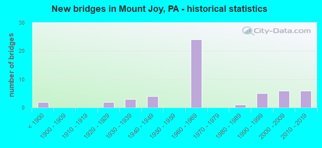
- New bridges - historical statistics
- 2Before 1900
- 21920-1929
- 31930-1939
- 41940-1949
- 241960-1969
- 11980-1989
- 51990-1999
- 62000-2009
- 62010-2019
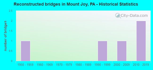
- Reconstructed bridges - Historical Statistics
- 11950-1959
- 01960-1969
- 01970-1979
- 01980-1989
- 11990-1999
- 12000-2009
- 22010-2019
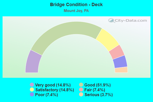
- Bridge Condition - Deck
- 14.8%Very good
- 51.9%Good
- 14.8%Satisfactory
- 7.4%Fair
- 7.4%Poor
- 3.7%Serious
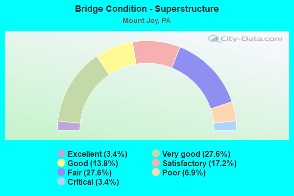
- Bridge Condition - Superstructure
- 3.4%Excellent
- 27.6%Very good
- 13.8%Good
- 17.2%Satisfactory
- 27.6%Fair
- 6.9%Poor
- 3.4%Critical
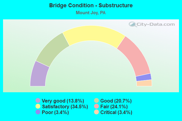
- Bridge Condition - Substructure
- 13.8%Very good
- 20.7%Good
- 34.5%Satisfactory
- 24.1%Fair
- 3.4%Poor
- 3.4%Critical
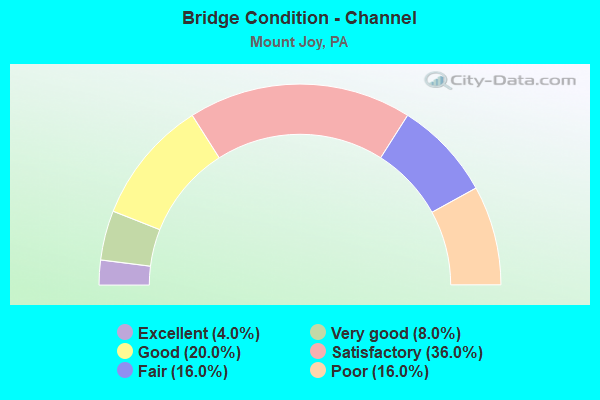
- Bridge Condition - Channel
- 4.0%Excellent
- 8.0%Very good
- 20.0%Good
- 36.0%Satisfactory
- 16.0%Fair
- 16.0%Poor
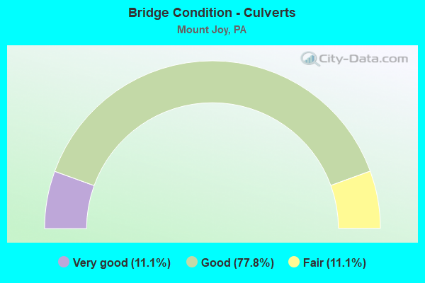
- Bridge Condition - Culverts
- 11.1%Very good
- 77.8%Good
- 11.1%Fair
Find on map >> Show street view
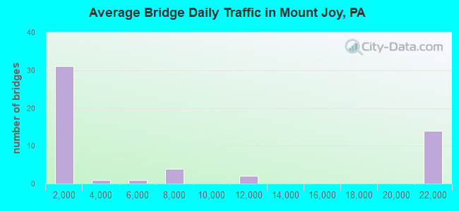
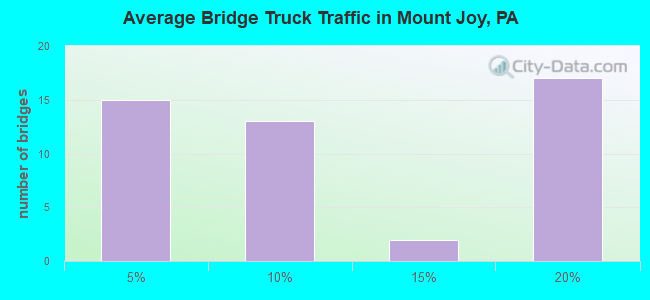
Structure Number: 21175, Location: 1.5 MI.N.E. FLORIN (Lat: 40.128228, Lng: -76.509022), Route carried "under" structure: State highway 283, Year Built: 1968, Structure Length: 0. m, Average Daily Traffic: 21,201 (year 2020), Truck Traffic: 17%, Features Intersected: PA 283; SR 0300, Facility Carried by Structure: RISSER MILL; T-350
Minimum Vertical Clearance: 4.52m (14.83ft), Kilometerpoint: 11.225, Lanes on structure: 2, Lanes under structure: 4, Material/Design: Prestressed concrete, Design/Construction: Box Beam or Girders - Single/Spread, Length of Maximum Span: 25.9m (85.0ft)
Find on map >> Show street view
Structure Number: 21177, Location: 2 MI.N. MT. JOY BORO (Lat: 40.130067, Lng: -76.493575), Route carried "under" structure: State highway , Year Built: 1968, Structure Length: 0. m, Average Daily Traffic: 1,198 (year 2020), Truck Traffic: 8%, Features Intersected: SR 4033,MILTON GROVE RD., Facility Carried by Structure: PA 283 EB; SR 0300
Minimum Vertical Clearance: 4.50m (14.76ft), Kilometerpoint: 1.157, Lanes on structure: 2, Lanes under structure: 2, Material/Design: Prestressed concrete, Design/Construction: Box Beam or Girders - Single/Spread, Length of Maximum Span: 11.9m (39.0ft)
Find on map >> Show street view
Structure Number: 21179, Location: 2 MI.N. OF MT. JOY (Lat: 40.130331, Lng: -76.493411), Route carried "under" structure: State highway , Year Built: 1968, Structure Length: 0. m, Average Daily Traffic: 1,198 (year 2020), Truck Traffic: 8%, Features Intersected: SR 4033 Milton Grove Rd, Facility Carried by Structure: PA 283 WB; SR 0300
Minimum Vertical Clearance: 4.82m (15.81ft), Kilometerpoint: 1.157, Lanes on structure: 2, Lanes under structure: 2, Material/Design: Prestressed concrete, Design/Construction: Box Beam or Girders - Single/Spread, Length of Maximum Span: 11.9m (39.0ft)
Find on map >> Show street view
Structure Number: 2118, Location: 0.25 MI.W. OF L.R. 36002 (Lat: 40.127858, Lng: -76.475858), Route carried "under" structure: State highway 283, Year Built: 1968, Structure Length: 0. m, Average Daily Traffic: 21,375 (year 2020), Truck Traffic: 16%, Features Intersected: SR 0300; PA 283, Facility Carried by Structure: STRICKLR RD; T-364
Minimum Vertical Clearance: 4.52m (14.83ft), Kilometerpoint: 13.704, Lanes on structure: 2, Lanes under structure: 2, Material/Design: Prestressed concrete, Design/Construction: Box Beam or Girders - Single/Spread, Length of Maximum Span: 21.3m (69.9ft)
Find on map >> Show street view
Structure Number: 2118, Location: 0.25 MI.W. OF L.R. 36002 (Lat: 40.127858, Lng: -76.475858), Route carried "under" structure: State highway 283, Year Built: 1968, Structure Length: 0. m, Average Daily Traffic: 21,201 (year 2020), Truck Traffic: 17%, Features Intersected: SR 0300; PA 283, Facility Carried by Structure: STRICKLR RD; T-364
Minimum Vertical Clearance: 4.39m (14.40ft), Kilometerpoint: 13.681, Lanes on structure: 2, Lanes under structure: 2, Material/Design: Prestressed concrete, Design/Construction: Box Beam or Girders - Single/Spread, Length of Maximum Span: 21.3m (69.9ft)
Find on map >> Show street view
Structure Number: 21181, Location: 1.5 MI. N.W. OF SALUNGA (Lat: 40.115239, Lng: -76.450547), Route carried "under" structure: State highway 283, Year Built: 1968, Structure Length: 0. m, Average Daily Traffic: 21,375 (year 2020), Truck Traffic: 16%, Features Intersected: SR 0300; PA 283, Facility Carried by Structure: ESBNSHDE RD; T-368
Minimum Vertical Clearance: 4.60m (15.09ft), Kilometerpoint: 16.182, Lanes on structure: 2, Lanes under structure: 4, Material/Design: Prestressed concrete, Design/Construction: Box Beam or Girders - Single/Spread, Length of Maximum Span: 21.9m (71.9ft)
Find on map >> Show street view
Structure Number: 21181, Location: 1.5 MI. N.W. OF SALUNGA (Lat: 40.115239, Lng: -76.450547), Route carried "under" structure: State highway 283, Year Built: 1968, Structure Length: 0. m, Average Daily Traffic: 21,201 (year 2020), Truck Traffic: 17%, Features Intersected: SR 0300; PA 283, Facility Carried by Structure: ESBNSHDE RD; T-368
Minimum Vertical Clearance: 4.60m (15.09ft), Kilometerpoint: 16.167, Lanes on structure: 2, Lanes under structure: 4, Material/Design: Prestressed concrete, Design/Construction: Box Beam or Girders - Single/Spread, Length of Maximum Span: 21.9m (71.9ft)
Find on map >> Show street view
Structure Number: 21322, Location: 2.5 MI. N.E. OF MT. JOY (Lat: 40.124594, Lng: -76.469153), Route carried "under" structure: State highway 283, Year Built: 1968, Structure Length: 0. m, Average Daily Traffic: 21,375 (year 2020), Truck Traffic: 16%, Features Intersected: PA 283; SR 0300, Facility Carried by Structure: PA 772; SR 0772
Minimum Vertical Clearance: 4.60m (15.09ft), Kilometerpoint: 14.566, Lanes on structure: 2, Lanes under structure: 2, Material/Design: Prestressed concrete, Design/Construction: Box Beam or Girders - Single/Spread, Length of Maximum Span: 26.8m (87.9ft)
Find on map >> Show street view
Structure Number: 21322, Location: 2.5 MI. N.E. OF MT. JOY (Lat: 40.124594, Lng: -76.469153), Route carried "under" structure: State highway 283, Year Built: 1968, Structure Length: 0. m, Average Daily Traffic: 21,201 (year 2020), Truck Traffic: 17%, Features Intersected: PA 283; SR 0300, Facility Carried by Structure: PA 772; SR 0772
Minimum Vertical Clearance: 4.60m (15.09ft), Kilometerpoint: 14.555, Lanes on structure: 2, Lanes under structure: 2, Material/Design: Prestressed concrete, Design/Construction: Box Beam or Girders - Single/Spread, Length of Maximum Span: 26.8m (87.9ft)
Find on map >> Show street view
Structure Number: 21709, Location: MOUNT JOY BOROUGH (Lat: 40.112042, Lng: -76.521908), Route carried "under" structure: City street , Year Built: 1942, Structure Length: 0. m, Average Daily Traffic: 100 (year 1983), Features Intersected: AMTRAK; BORO STREETS, Facility Carried by Structure: SR 4015
Minimum Vertical Clearance: 4.06m (13.32ft), Kilometerpoint: 0.000, Lanes on structure: 2, Lanes under structure: 6, Material/Design: Steel continuous, Design/Construction: Stringer/Multi-beam, Length of Maximum Span: 21.6m (70.9ft)
Find on map >> Show street view
Structure Number: 21709, Location: MOUNT JOY BOROUGH (Lat: 40.112042, Lng: -76.521908), Route carried "under" structure: City street , Year Built: 1942, Structure Length: 0. m, Average Daily Traffic: 100 (year 1983), Features Intersected: AMTRAK; BORO STREETS, Facility Carried by Structure: SR 4015
Minimum Vertical Clearance: 5.79m (19.00ft), Kilometerpoint: 0.000, Lanes on structure: 2, Lanes under structure: 6, Material/Design: Steel continuous, Design/Construction: Stringer/Multi-beam, Length of Maximum Span: 21.6m (70.9ft)
Find on map >> Show street view
Structure Number: 21709, Location: MOUNT JOY BOROUGH (Lat: 40.112042, Lng: -76.521908), Route carried "under" structure: City street , Year Built: 1942, Structure Length: 0. m, Average Daily Traffic: 100 (year 1983), Features Intersected: AMTRAK; BORO STREETS, Facility Carried by Structure: SR 4015
Minimum Vertical Clearance: 4.44m (14.57ft), Kilometerpoint: 0.000, Lanes on structure: 2, Lanes under structure: 6, Material/Design: Steel continuous, Design/Construction: Stringer/Multi-beam, Length of Maximum Span: 21.6m (70.9ft)
Find on map >> Show street view
Structure Number: 21713, Location: OVER PA 283 (Lat: 40.130639, Lng: -76.530739), Route carried "under" structure: State highway 283, Year Built: 1969, Structure Length: 0. m, Average Daily Traffic: 21,375 (year 2020), Truck Traffic: 16%, Features Intersected: PA 283; SR 0300, Facility Carried by Structure: SR 4017
Minimum Vertical Clearance: 4.65m (15.26ft), Kilometerpoint: 8.856, Lanes on structure: 2, Lanes under structure: 4, Material/Design: Prestressed concrete, Design/Construction: Stringer/Multi-beam, Length of Maximum Span: 20.7m (67.9ft)
Find on map >> Show street view
Structure Number: 21713, Location: OVER PA 283 (Lat: 40.130639, Lng: -76.530739), Route carried "under" structure: State highway 283, Year Built: 1969, Structure Length: 0. m, Average Daily Traffic: 21,201 (year 2020), Truck Traffic: 17%, Features Intersected: PA 283; SR 0300, Facility Carried by Structure: SR 4017
Minimum Vertical Clearance: 4.50m (14.76ft), Kilometerpoint: 8.834, Lanes on structure: 2, Lanes under structure: 4, Material/Design: Prestressed concrete, Design/Construction: Stringer/Multi-beam, Length of Maximum Span: 20.7m (67.9ft)