Bridge Statistics for Mount Olive, Mississippi (MS)
Condition, Traffic, Stress, Structural Evaluation, Project Costs
- National Bridge Inventory (NBI) Statistics
- 43Number of bridges
- 495ft / 151mTotal length
- $1,208,283,000Total costs
- 94,530Total average daily traffic
- 19,009Total average daily truck traffic
- 106,033Total future (year 2034) average daily traffic
- National Bridge Inventory (NBI) Registered Bridges for Mount Olive
- No street view available for this location
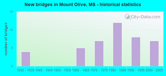
- New bridges - historical statistics
- 41930-1939
- 51960-1969
- 71970-1979
- 121980-1989
- 81990-1999
- 72000-2009
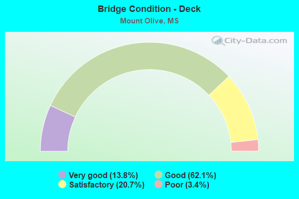
- Bridge Condition - Deck
- 13.8%Very good
- 62.1%Good
- 20.7%Satisfactory
- 3.4%Poor
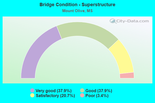
- Bridge Condition - Superstructure
- 37.9%Very good
- 37.9%Good
- 20.7%Satisfactory
- 3.4%Poor
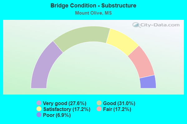
- Bridge Condition - Substructure
- 27.6%Very good
- 31.0%Good
- 17.2%Satisfactory
- 17.2%Fair
- 6.9%Poor
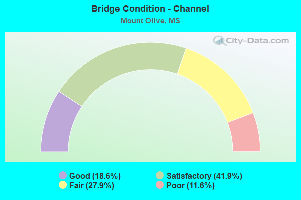
- Bridge Condition - Channel
- 18.6%Good
- 41.9%Satisfactory
- 27.9%Fair
- 11.6%Poor
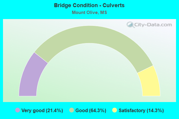
- Bridge Condition - Culverts
- 21.4%Very good
- 64.3%Good
- 14.3%Satisfactory
Find on map >> Show street view
Structure Number: 21000490161051A, Location: 0.8 MI S SR 35 (Lat: 31.741014, Lng: -89.642114), Route carried "on" structure: US 49, Year Built: 2001, Status: Open, Structure Length: 3.60m (11.81ft), Average Daily Traffic: 7,500 (year 2020), Truck Traffic: 24%, Average Future Daily Traffic: 8,000 (year 2040), Design Load: HS 20, Features Intersected: LEONARDS MILL CREEK
Minimum Vertical Clearance: 30+ m (98+ ft), Kilometerpoint: 5.840, Lanes on structure: 3, Base Highway Network: Yes (Inventory Route: 4, Subroute: 1), Owner: State Highway Agency, Approaching Roadway Width: 12.6m (41.3ft), Skew: 13 degrees, Material/Design: Prestressed concrete continuous, Design/Construction: Stringer/Multi-beam, Number Of Spans In Main Unit: 3, Length of Maximum Span: 12.0m (39.4ft), Curb-To-Curb Width: 16.2m (53.1ft), Out-to-Out Width: 17.1m (56.1ft)
Condition: Deck: Very good, Superstructure: Very good, Substructure: Very good, Channel: Good, Operating Rating: 64.4 metric tons, Method Used To Determine Operating Rating: Load Factor (LF), Inventory Rating: 38.5 metric tons, Method Used To Determine Inventory Rating: Load Factor (LF), Structural Evaluation: Equal to present desirable criteria, Deck Geometry: Better than present minimum criteria, Waterway Adequacy: Equal to present desirable criteria, Approach Roadway Alignment: Equal to present desirable criteria, Designated Inspection Frequency: Every 24 months, Inspection Date: July 2021, Deck Structure Type: Concrete Cast-file-Place
Find on map >> Show street view
Structure Number: 21000490161051B, Location: 0.8 MI S SR 35 (Lat: 31.740808, Lng: -89.641564), Route carried "on" structure: US 49, Year Built: 1964, Status: Open, Structure Length: 1.07m (3.51ft), Average Daily Traffic: 7,500 (year 2020), Truck Traffic: 25%, Average Future Daily Traffic: 8,000 (year 2040), Design Load: HS 15, Features Intersected: LEONARDS MILL CREEK
Minimum Vertical Clearance: 30+ m (98+ ft), Kilometerpoint: 40.451, Lanes on structure: 2, Base Highway Network: Yes (Inventory Route: 4, Subroute: 1), Owner: State Highway Agency, Approaching Roadway Width: 13.4m (44.0ft), Material/Design: Concrete, Design/Construction: Culvert, Number Of Spans In Main Unit: 2, Length of Maximum Span: 4.3m (14.1ft)
Condition: Channel: Satisfactory, Culverts: Good, Operating Rating: 52.2 metric tons, Method Used To Determine Operating Rating: Load Factor (LF), Inventory Rating: 31.5 metric tons, Method Used To Determine Inventory Rating: Load Factor (LF), Structural Evaluation: Better than present minimum criteria, Waterway Adequacy: Equal to present desirable criteria, Approach Roadway Alignment: Equal to present desirable criteria, Designated Inspection Frequency: Every 24 months, Inspection Date: July 2021, Deck Structure Type: Concrete Cast-file-Place, Wearing Surface/Protective System: Deck Protection: Epoxy Coated Reinforcing
Find on map >> Show street view
Structure Number: 21000490161069, Location: 0.7 MI N SR 35 (Lat: 31.760672, Lng: -89.669806), Route carried "on" structure: US 49, Year Built: 1964, Status: Open, Structure Length: 0.79m (2.59ft), Average Daily Traffic: 21,000 (year 2020), Truck Traffic: 20%, Average Future Daily Traffic: 23,000 (year 2040), Design Load: HS 15, Features Intersected: UNNAMED STREAM
Minimum Vertical Clearance: 30+ m (98+ ft), Kilometerpoint: 43.987, Lanes on structure: 4, Base Highway Network: Yes (Inventory Route: 4, Subroute: 1), Owner: State Highway Agency, Approaching Roadway Width: 42.1m (138.1ft), Material/Design: Concrete, Design/Construction: Culvert, Number Of Spans In Main Unit: 2, Length of Maximum Span: 3.7m (12.1ft)
Condition: Channel: Satisfactory, Culverts: Satisfactory, Inventory Rating: 66.6 metric tons, Method Used To Determine Inventory Rating: Load Factor (LF), Structural Evaluation: Equal to present minimum criteria, Waterway Adequacy: Equal to present desirable criteria, Approach Roadway Alignment: Equal to present desirable criteria, Length Of Structure Improvement: 1.58m (5.18ft), Designated Inspection Frequency: Every 24 months, Inspection Date: June 2021, Bridge Improvement Cost: $100,000,000, Roadway Improvement Cost: $10,000,000, Total Project Cost: $315,000,000, Deck Structure Type: Concrete Cast-file-Place
Find on map >> Show street view
Structure Number: 2100049016108, Location: 1.4 MI N SR 35 (Lat: 31.774425, Lng: -89.678578), Route carried "on" structure: US 49, Year Built: 1964, Status: Open, Structure Length: 1.07m (3.51ft), Average Daily Traffic: 21,000 (year 2020), Truck Traffic: 20%, Average Future Daily Traffic: 23,000 (year 2040), Design Load: HS 15, Features Intersected: UNNAMED STREAM
Minimum Vertical Clearance: 30+ m (98+ ft), Kilometerpoint: 45.760, Lanes on structure: 4, Base Highway Network: Yes (Inventory Route: 4, Subroute: 1), Owner: State Highway Agency, Approaching Roadway Width: 41.5m (136.2ft), Material/Design: Concrete, Design/Construction: Culvert, Number Of Spans In Main Unit: 2, Length of Maximum Span: 4.9m (16.1ft)
Condition: Channel: Fair, Culverts: Good, Operating Rating: 43.6 metric tons, Method Used To Determine Operating Rating: Load Factor (LF), Inventory Rating: 26.1 metric tons, Method Used To Determine Inventory Rating: Load Factor (LF), Structural Evaluation: Equal to present minimum criteria, Waterway Adequacy: Equal to present desirable criteria, Approach Roadway Alignment: Equal to present desirable criteria, Length Of Structure Improvement: 1.07m (3.51ft), Designated Inspection Frequency: Every 24 months, Inspection Date: June 2021, Bridge Improvement Cost: $93,000,000, Roadway Improvement Cost: $200,000,000, Total Project Cost: $340,000,000, Deck Structure Type: Concrete Cast-file-Place
Find on map >> Show street view
Structure Number: 21000490641099, Location: 1.1 MI N COVINGTON CL (Lat: 31.794414, Lng: -89.688333), Route carried "on" structure: US 49, Year Built: 1999, Status: Open, Structure Length: 4.57m (14.99ft), Average Daily Traffic: 9,000 (year 2020), Truck Traffic: 28%, Average Future Daily Traffic: 10,000 (year 2040), Design Load: HS 20, Features Intersected: USPAHA CREEK
Minimum Vertical Clearance: 30+ m (98+ ft), Kilometerpoint: 41.552, Lanes on structure: 2, Base Highway Network: Yes (Inventory Route: 4, Subroute: 1), Owner: State Highway Agency, Approaching Roadway Width: 12.2m (40.0ft), Skew: 2 degrees, Material/Design: Prestressed concrete continuous, Design/Construction: Stringer/Multi-beam, Number Of Spans In Main Unit: 3, Length of Maximum Span: 15.2m (49.9ft), Curb-To-Curb Width: 12.2m (40.0ft), Out-to-Out Width: 12.9m (42.3ft)
Condition: Deck: Good, Superstructure: Very good, Substructure: Very good, Channel: Satisfactory, Operating Rating: 59.2 metric tons, Method Used To Determine Operating Rating: Load Factor (LF), Inventory Rating: 34.4 metric tons, Method Used To Determine Inventory Rating: Load Factor (LF), Structural Evaluation: Equal to present desirable criteria, Deck Geometry: Better than present minimum criteria, Waterway Adequacy: Equal to present desirable criteria, Approach Roadway Alignment: Equal to present desirable criteria, Designated Inspection Frequency: Every 24 months, Inspection Date: May 2021, Deck Structure Type: Concrete Cast-file-Place
Find on map >> Show street view
Structure Number: 21000490641099A, Location: 1.1 MI N COVINGTON CL (Lat: 31.794083, Lng: -89.688514), Route carried "on" structure: ServiceOther road 49, Year Built: 1935, Status: Open, Structure Length: 2.74m (8.99ft), Average Daily Traffic: 630 (year 2020), Truck Traffic: 8%, Average Future Daily Traffic: 630 (year 2040), Design Load: H 15, Features Intersected: USPAHA CREEK
Minimum Vertical Clearance: 30+ m (98+ ft), Kilometerpoint: 1.746, Lanes on structure: 2, Owner: State Highway Agency, Approaching Roadway Width: 7.3m (24.0ft), Material/Design: Steel, Design/Construction: Stringer/Multi-beam, Number Of Spans In Main Unit: 3, Length of Maximum Span: 9.1m (29.9ft), Curb or Sidewalk Widths: Left: 0.2m (0.7ft), Right: 0.2m (0.7ft), Curb-To-Curb Width: 7.3m (24.0ft), Out-to-Out Width: 7.7m (25.3ft)
Condition: Deck: Good, Superstructure: Good, Substructure: Good, Channel: Poor, Operating Rating: 49.3 metric tons, Method Used To Determine Operating Rating: Load Factor (LF), Inventory Rating: 29.5 metric tons, Method Used To Determine Inventory Rating: Load Factor (LF), Structural Evaluation: Better than present minimum criteria, Deck Geometry: Meets minimum limits, Waterway Adequacy: Better than present minimum criteria, Approach Roadway Alignment: Equal to present desirable criteria, Length Of Structure Improvement: 2.74m (8.99ft), Designated Inspection Frequency: Every 24 months, Inspection Date: May 2021, Bridge Improvement Cost: $316,000,000, Roadway Improvement Cost: $200,000,000, Total Project Cost: $550,000,000, Deck Structure Type: Concrete Cast-file-Place, Wearing Surface/Protective System: Wearing Surface: Bituminous
Find on map >> Show street view
Structure Number: 21000490641099B, Location: 1.1 MI N COVINGTON CL (Lat: 31.794117, Lng: -89.687872), Route carried "on" structure: US 49, Year Built: 1964, Status: Open, Structure Length: 1.37m (4.49ft), Average Daily Traffic: 9,000 (year 2020), Truck Traffic: 28%, Average Future Daily Traffic: 10,000 (year 2040), Design Load: H 20, Features Intersected: USPAHA CREEK
Minimum Vertical Clearance: 30+ m (98+ ft), Kilometerpoint: 1.783, Lanes on structure: 2, Base Highway Network: Yes (Inventory Route: 4, Subroute: 1), Owner: State Highway Agency, Approaching Roadway Width: 12.2m (40.0ft), Skew: 3 degrees, Material/Design: Concrete, Design/Construction: Culvert, Number Of Spans In Main Unit: 2, Length of Maximum Span: 5.5m (18.0ft)
Condition: Channel: Satisfactory, Culverts: Satisfactory, Operating Rating: 57.6 metric tons, Method Used To Determine Operating Rating: Load Factor (LF), Inventory Rating: 34.5 metric tons, Method Used To Determine Inventory Rating: Load Factor (LF), Structural Evaluation: Equal to present minimum criteria, Waterway Adequacy: Equal to present desirable criteria, Approach Roadway Alignment: Equal to present desirable criteria, Designated Inspection Frequency: Every 24 months, Inspection Date: April 2021, Deck Structure Type: Concrete Cast-file-Place
Find on map >> Show street view
Structure Number: 31000350160636, Location: 0.7 MI N US 49 (Lat: 31.755208, Lng: -89.645947), Route carried "on" structure: State highway 35, Year Built: 1981, Status: Open, Structure Length: 0.98m (3.22ft), Average Daily Traffic: 3,000 (year 2020), Truck Traffic: 14%, Average Future Daily Traffic: 3,400 (year 2040), Design Load: HS 20+Mod, Features Intersected: RELIEF
Minimum Vertical Clearance: 30+ m (98+ ft), Kilometerpoint: 20.270, Lanes on structure: 2, Base Highway Network: Yes (Inventory Route: 3, Subroute: 2), Owner: State Highway Agency, Approaching Roadway Width: 14.0m (45.9ft), Material/Design: Concrete, Design/Construction: Culvert, Number Of Spans In Main Unit: 2, Length of Maximum Span: 4.9m (16.1ft)
Condition: Channel: Good, Culverts: Good, Operating Rating: 49.2 metric tons, Method Used To Determine Operating Rating: Load Factor (LF), Inventory Rating: 29.5 metric tons, Method Used To Determine Inventory Rating: Load Factor (LF), Structural Evaluation: Better than present minimum criteria, Waterway Adequacy: Equal to present desirable criteria, Approach Roadway Alignment: Equal to present desirable criteria, Designated Inspection Frequency: Every 24 months, Inspection Date: June 2021, Deck Structure Type: Concrete Cast-file-Place
Find on map >> Show street view
Structure Number: 31000350160638, Location: 0.9 MI N US 49 (Lat: 31.757975, Lng: -89.644025), Route carried "on" structure: State highway 35, Year Built: 1981, Status: Open, Structure Length: 29.87m (98.00ft), Average Daily Traffic: 3,000 (year 2020), Truck Traffic: 14%, Average Future Daily Traffic: 3,400 (year 2040), Design Load: HS 20, Features Intersected: OKATOMA CREEK
Minimum Vertical Clearance: 30+ m (98+ ft), Kilometerpoint: 20.625, Lanes on structure: 2, Base Highway Network: Yes (Inventory Route: 3, Subroute: 2), Owner: State Highway Agency, Approaching Roadway Width: 12.2m (40.0ft), Material/Design: Prestressed concrete, Design/Construction: Stringer/Multi-beam, Number Of Spans In Main Unit: 1, Number Of Approach Spans: 22, Length of Maximum Span: 30.5m (100.1ft), Curb-To-Curb Width: 12.2m (40.0ft), Out-to-Out Width: 13.0m (42.7ft)
Condition: Deck: Good, Superstructure: Good, Substructure: Good, Channel: Good, Operating Rating: 56.2 metric tons, Method Used To Determine Operating Rating: Load Factor (LF), Inventory Rating: 24.8 metric tons, Method Used To Determine Inventory Rating: Load Factor (LF), Structural Evaluation: Equal to present minimum criteria, Deck Geometry: Equal to present minimum criteria, Waterway Adequacy: Equal to present desirable criteria, Approach Roadway Alignment: Equal to present desirable criteria, Designated Inspection Frequency: Every 24 months, Inspection Date: June 2021, Deck Structure Type: Concrete Cast-file-Place
Find on map >> Show street view
Structure Number: 31001490161069, Location: 0.5 MI N SR 35 (Lat: 31.758489, Lng: -89.651914), Route carried "on" structure: State highway 149, Year Built: 1930, Status: Open, Structure Length: 2.19m (7.19ft), Average Daily Traffic: 1,100 (year 2020), Truck Traffic: 7%, Average Future Daily Traffic: 1,200 (year 2040), Design Load: HS 15, Features Intersected: LEONARDS MILL CREEK
Minimum Vertical Clearance: 30+ m (98+ ft), Kilometerpoint: 1.693, Lanes on structure: 2, Owner: State Highway Agency, Approaching Roadway Width: 7.3m (24.0ft), Material/Design: Concrete, Design/Construction: Tee Beam, Number Of Spans In Main Unit: 3, Length of Maximum Span: 7.3m (24.0ft), Curb or Sidewalk Widths: Left: 0.2m (0.7ft), Right: 0.2m (0.7ft), Curb-To-Curb Width: 7.3m (24.0ft), Out-to-Out Width: 8.2m (26.9ft)
Condition: Deck: Good, Superstructure: Satisfactory, Substructure: Satisfactory, Channel: Fair, Operating Rating: 49.5 metric tons, Method Used To Determine Operating Rating: Load Factor (LF), Inventory Rating: 29.8 metric tons, Method Used To Determine Inventory Rating: Load Factor (LF), Structural Evaluation: Equal to present minimum criteria, Deck Geometry: Meets minimum limits, Waterway Adequacy: Better than present minimum criteria, Approach Roadway Alignment: Equal to present desirable criteria, Designated Inspection Frequency: Every 24 months, Inspection Date: June 2021, Deck Structure Type: Concrete Cast-file-Place, Wearing Surface/Protective System: Wearing Surface: Bituminous
Find on map >> Show street view
Structure Number: 31001490161081, Location: 2.5 MI N SR 35 (Lat: 31.774783, Lng: -89.677175), Route carried "on" structure: State highway 149, Year Built: 1930, Status: Open, Structure Length: 2.20m (7.22ft), Average Daily Traffic: 900 (year 2020), Truck Traffic: 4%, Average Future Daily Traffic: 970 (year 2040), Design Load: HS 15, Features Intersected: UNNAMED STREAM
Minimum Vertical Clearance: 30+ m (98+ ft), Kilometerpoint: 4.822, Lanes on structure: 2, Owner: State Highway Agency, Approaching Roadway Width: 7.3m (24.0ft), Material/Design: Concrete, Design/Construction: Tee Beam, Number Of Spans In Main Unit: 2, Length of Maximum Span: 7.3m (24.0ft), Curb or Sidewalk Widths: Left: 0.2m (0.7ft), Right: 0.2m (0.7ft), Curb-To-Curb Width: 7.3m (24.0ft), Out-to-Out Width: 8.2m (26.9ft)
Condition: Deck: Satisfactory, Superstructure: Satisfactory, Substructure: Satisfactory, Channel: Fair, Operating Rating: 54.2 metric tons, Method Used To Determine Operating Rating: Load Factor (LF), Inventory Rating: 32.5 metric tons, Method Used To Determine Inventory Rating: Load Factor (LF), Structural Evaluation: Equal to present minimum criteria, Deck Geometry: Meets minimum limits, Waterway Adequacy: Better than present minimum criteria, Approach Roadway Alignment: Equal to present desirable criteria, Designated Inspection Frequency: Every 24 months, Inspection Date: June 2021, Deck Structure Type: Concrete Cast-file-Place, Wearing Surface/Protective System: Wearing Surface: Bituminous
Find on map >> Show street view
Structure Number: 31005320160011, Location: 0.9 MI E SR 35 (Lat: 31.759108, Lng: -89.624525), Route carried "on" structure: State highway 532, Year Built: 1987, Status: Open, Structure Length: 2.83m (9.28ft), Average Daily Traffic: 1,000 (year 2020), Truck Traffic: 11%, Average Future Daily Traffic: 1,000 (year 2040), Design Load: HS 20, Features Intersected: STREAM
Minimum Vertical Clearance: 30+ m (98+ ft), Kilometerpoint: 1.571, Lanes on structure: 2, Owner: State Highway Agency, Approaching Roadway Width: 9.1m (29.9ft), Material/Design: Concrete, Design/Construction: Channel Beam, Number Of Spans In Main Unit: 3, Length of Maximum Span: 9.4m (30.8ft), Curb-To-Curb Width: 9.1m (29.9ft), Out-to-Out Width: 10.1m (33.1ft)
Condition: Deck: Very good, Superstructure: Very good, Substructure: Very good, Channel: Good, Operating Rating: 43.5 metric tons, Method Used To Determine Operating Rating: Load Factor (LF), Inventory Rating: 26.0 metric tons, Method Used To Determine Inventory Rating: Load Factor (LF), Structural Evaluation: Equal to present minimum criteria, Deck Geometry: Equal to present minimum criteria, Waterway Adequacy: Equal to present desirable criteria, Approach Roadway Alignment: Equal to present desirable criteria, Designated Inspection Frequency: Every 24 months, Inspection Date: June 2021, Deck Structure Type: Concrete Precast Panels
Find on map >> Show street view
Structure Number: 31005320160016, Location: 1.4 MI E SR 35 (Lat: 31.754561, Lng: -89.618136), Route carried "on" structure: State highway 532, Year Built: 1988, Status: Open, Structure Length: 1.16m (3.81ft), Average Daily Traffic: 1,000 (year 2020), Truck Traffic: 11%, Average Future Daily Traffic: 1,000 (year 2040), Design Load: HS 20, Features Intersected: STREAM
Minimum Vertical Clearance: 30+ m (98+ ft), Kilometerpoint: 2.379, Lanes on structure: 2, Owner: State Highway Agency, Approaching Roadway Width: 9.1m (29.9ft), Material/Design: Concrete, Design/Construction: Channel Beam, Number Of Spans In Main Unit: 2, Length of Maximum Span: 5.8m (19.0ft), Curb-To-Curb Width: 9.1m (29.9ft), Out-to-Out Width: 10.1m (33.1ft)
Condition: Deck: Very good, Superstructure: Very good, Substructure: Very good, Channel: Good, Operating Rating: 53.2 metric tons, Method Used To Determine Operating Rating: Load Factor (LF), Inventory Rating: 31.8 metric tons, Method Used To Determine Inventory Rating: Load Factor (LF), Structural Evaluation: Better than present minimum criteria, Deck Geometry: Equal to present minimum criteria, Waterway Adequacy: Equal to present desirable criteria, Approach Roadway Alignment: Equal to present desirable criteria, Designated Inspection Frequency: Every 24 months, Inspection Date: June 2021, Deck Structure Type: Concrete Precast Panels
Find on map >> Show street view
Structure Number: 31005320160038, Location: 3.6 MI E SR 35 (Lat: 31.753858, Lng: -89.584311), Route carried "on" structure: State highway 532, Year Built: 1988, Status: Open, Structure Length: 3.26m (10.70ft), Average Daily Traffic: 1,000 (year 2020), Truck Traffic: 11%, Average Future Daily Traffic: 1,000 (year 2040), Design Load: HS 20, Features Intersected: BLAKELY CREEK
Minimum Vertical Clearance: 30+ m (98+ ft), Kilometerpoint: 5.827, Lanes on structure: 2, Owner: State Highway Agency, Approaching Roadway Width: 9.1m (29.9ft), Material/Design: Concrete, Design/Construction: Channel Beam, Number Of Spans In Main Unit: 1, Number Of Approach Spans: 4, Length of Maximum Span: 9.4m (30.8ft), Curb-To-Curb Width: 9.1m (29.9ft), Out-to-Out Width: 10.1m (33.1ft)
Condition: Deck: Very good, Superstructure: Very good, Substructure: Very good, Channel: Satisfactory, Operating Rating: 43.5 metric tons, Method Used To Determine Operating Rating: Load Factor (LF), Inventory Rating: 26.0 metric tons, Method Used To Determine Inventory Rating: Load Factor (LF), Structural Evaluation: Equal to present minimum criteria, Deck Geometry: Equal to present minimum criteria, Waterway Adequacy: Equal to present desirable criteria, Approach Roadway Alignment: Equal to present desirable criteria, Designated Inspection Frequency: Every 24 months, Inspection Date: June 2021, Deck Structure Type: Concrete Precast Panels
Find on map >> Show street view
Structure Number: SA1600000000088, Location: SEC 3 T 9N R16W (Lat: 31.775069, Lng: -89.596878), Route carried "on" structure: County highway 191, Year Built: 1983, Status: Open, Structure Length: 1.16m (3.81ft), Average Daily Traffic: 165 (year 2018), Truck Traffic: 8%, Average Future Daily Traffic: 182 (year 2038), Design Load: H 15, Features Intersected: BLAKELY CREEK, Facility Carried by Structure: HORSESHOE RD
Minimum Vertical Clearance: 30+ m (98+ ft), Kilometerpoint: 3.701, Lanes on structure: 2, Owner: County Highway Agency, Approaching Roadway Width: 4.9m (16.1ft), Material/Design: Concrete, Design/Construction: Channel Beam, Number Of Spans In Main Unit: 2, Length of Maximum Span: 5.8m (19.0ft), Curb or Sidewalk Widths: Left: 0.2m (0.7ft), Right: 0.2m (0.7ft), Curb-To-Curb Width: 6.0m (19.7ft), Out-to-Out Width: 6.4m (21.0ft)
Condition: Deck: Satisfactory, Superstructure: Satisfactory, Substructure: Satisfactory, Channel: Fair, Operating Rating: 41.9 metric tons, Method Used To Determine Operating Rating: Load Factor (LF), Inventory Rating: 25.1 metric tons, Method Used To Determine Inventory Rating: Load Factor (LF), Structural Evaluation: Equal to present minimum criteria, Deck Geometry: High priority of corrective action, Waterway Adequacy: Better than present minimum criteria, Approach Roadway Alignment: Equal to present desirable criteria, Length Of Structure Improvement: 2.38m (7.81ft), Designated Inspection Frequency: Every 24 months, Inspection Date: October 2020, Bridge Improvement Cost: $142,000, Roadway Improvement Cost: $15,000, Total Project Cost: $175,000 ( Estimate for 2018), Deck Structure Type: Concrete Precast Panels, Wearing Surface/Protective System: Wearing Surface: Monolithic Concrete
Find on map >> Show street view
Structure Number: SA160000000009, Location: SEC 7 T 9N R16W (Lat: 31.761817, Lng: -89.647736), Route carried "on" structure: County highway 903, Year Built: 1996, Status: Open, Structure Length: 4.72m (15.49ft), Average Daily Traffic: 300 (year 2018), Truck Traffic: 8%, Average Future Daily Traffic: 450 (year 2038), Design Load: HS 20, Features Intersected: RELIEF FOR OKATOMA CREEK, Facility Carried by Structure: OLD MISS HWY 35
Minimum Vertical Clearance: 30+ m (98+ ft), Kilometerpoint: 0.482, Lanes on structure: 2, Owner: County Highway Agency, Approaching Roadway Width: 7.0m (23.0ft), Material/Design: Concrete, Design/Construction: Channel Beam, Number Of Spans In Main Unit: 5, Length of Maximum Span: 9.4m (30.8ft), Curb or Sidewalk Widths: Left: 0.2m (0.7ft), Right: 0.2m (0.7ft), Curb-To-Curb Width: 7.3m (24.0ft), Out-to-Out Width: 7.7m (25.3ft)
Condition: Deck: Good, Superstructure: Good, Substructure: Good, Channel: Satisfactory, Operating Rating: 59.8 metric tons, Method Used To Determine Operating Rating: Load Factor (LF), Inventory Rating: 36.0 metric tons, Method Used To Determine Inventory Rating: Load Factor (LF), Structural Evaluation: Better than present minimum criteria, Deck Geometry: Somewhat better than minimum adequacy, Waterway Adequacy: Equal to present desirable criteria, Approach Roadway Alignment: Equal to present desirable criteria, Designated Inspection Frequency: Every 24 months, Inspection Date: September 2021, Deck Structure Type: Concrete Precast Panels
Find on map >> Show street view
Structure Number: SA1600000000091, Location: SEC 7 T 9N R16W (Lat: 31.762414, Lng: -89.645844), Route carried "on" structure: County highway 903, Year Built: 1996, Status: Open, Structure Length: 8.50m (27.89ft), Average Daily Traffic: 300 (year 2018), Truck Traffic: 8%, Average Future Daily Traffic: 450 (year 2038), Design Load: HS 20, Features Intersected: OKATOMA CREEK, Facility Carried by Structure: OLD MISS HWY 35
Minimum Vertical Clearance: 30+ m (98+ ft), Kilometerpoint: 0.643, Lanes on structure: 2, Owner: County Highway Agency, Approaching Roadway Width: 6.1m (20.0ft), Material/Design: Concrete, Design/Construction: Channel Beam, Number Of Spans In Main Unit: 9, Length of Maximum Span: 9.4m (30.8ft), Curb or Sidewalk Widths: Left: 0.2m (0.7ft), Right: 0.2m (0.7ft), Curb-To-Curb Width: 7.3m (24.0ft), Out-to-Out Width: 7.7m (25.3ft)
Condition: Deck: Good, Superstructure: Good, Substructure: Good, Channel: Satisfactory, Operating Rating: 59.8 metric tons, Method Used To Determine Operating Rating: Load Factor (LF), Inventory Rating: 36.0 metric tons, Method Used To Determine Inventory Rating: Load Factor (LF), Structural Evaluation: Better than present minimum criteria, Deck Geometry: Somewhat better than minimum adequacy, Waterway Adequacy: Equal to present desirable criteria, Approach Roadway Alignment: Equal to present desirable criteria, Designated Inspection Frequency: Every 24 months, Inspection Date: October 2021, Deck Structure Type: Concrete Precast Panels
Find on map >> Show street view
Structure Number: SA1600000000092, Location: SEC 7 T 9N R16W (Lat: 31.763003, Lng: -89.643989), Route carried "on" structure: County highway 903, Year Built: 1996, Status: Open, Structure Length: 3.78m (12.40ft), Average Daily Traffic: 300 (year 2018), Truck Traffic: 8%, Average Future Daily Traffic: 450 (year 2038), Design Load: HS 20, Features Intersected: RELIEF FOR OKATOMA CREEK, Facility Carried by Structure: OLD MISS HWY 35
Minimum Vertical Clearance: 30+ m (98+ ft), Kilometerpoint: 0.804, Lanes on structure: 2, Owner: County Highway Agency, Approaching Roadway Width: 6.1m (20.0ft), Material/Design: Concrete, Design/Construction: Channel Beam, Number Of Spans In Main Unit: 4, Length of Maximum Span: 9.4m (30.8ft), Curb or Sidewalk Widths: Left: 0.2m (0.7ft), Right: 0.2m (0.7ft), Curb-To-Curb Width: 7.3m (24.0ft), Out-to-Out Width: 7.7m (25.3ft)
Condition: Deck: Good, Superstructure: Good, Substructure: Good, Channel: Satisfactory, Operating Rating: 59.8 metric tons, Method Used To Determine Operating Rating: Load Factor (LF), Inventory Rating: 36.0 metric tons, Method Used To Determine Inventory Rating: Load Factor (LF), Structural Evaluation: Better than present minimum criteria, Deck Geometry: Somewhat better than minimum adequacy, Waterway Adequacy: Equal to present desirable criteria, Approach Roadway Alignment: Equal to present desirable criteria, Designated Inspection Frequency: Every 24 months, Inspection Date: September 2021, Deck Structure Type: Concrete Precast Panels, Wearing Surface/Protective System: Wearing Surface: Monolithic Concrete
Find on map >> Show street view
Structure Number: SA1600000000095, Location: SEC 10 T 9N R16W (Lat: 31.764153, Lng: -89.588867), Route carried "on" structure: County highway 190, Year Built: 1987, Status: Open, Structure Length: 2.32m (7.61ft), Average Daily Traffic: 165 (year 2021), Truck Traffic: 8%, Average Future Daily Traffic: 183 (year 2041), Design Load: H 15, Features Intersected: BLAKELY CREEK, Facility Carried by Structure: HORSESHOE RD
Minimum Vertical Clearance: 30+ m (98+ ft), Kilometerpoint: 1.609, Lanes on structure: 2, Owner: County Highway Agency, Approaching Roadway Width: 6.1m (20.0ft), Material/Design: Concrete, Design/Construction: Channel Beam, Number Of Spans In Main Unit: 4, Length of Maximum Span: 5.8m (19.0ft), Curb or Sidewalk Widths: Left: 0.2m (0.7ft), Right: 0.2m (0.7ft), Curb-To-Curb Width: 7.1m (23.3ft), Out-to-Out Width: 7.5m (24.6ft)
Condition: Deck: Good, Superstructure: Good, Substructure: Fair, Channel: Satisfactory, Operating Rating: 41.1 metric tons, Method Used To Determine Operating Rating: Allowable Stress (AS), Inventory Rating: 24.8 metric tons, Method Used To Determine Inventory Rating: Allowable Stress (AS), Structural Evaluation: Somewhat better than minimum adequacy, Deck Geometry: Meets minimum limits, Waterway Adequacy: Equal to present desirable criteria, Approach Roadway Alignment: Equal to present desirable criteria, Length Of Structure Improvement: 3.11m (10.20ft), Designated Inspection Frequency: Every 24 months, Inspection Date: October 2021, Bridge Improvement Cost: $370,000, Roadway Improvement Cost: $70,000, Total Project Cost: $440,000 ( Estimate for 2021), Deck Structure Type: Concrete Precast Panels, Wearing Surface/Protective System: Wearing Surface: Monolithic Concrete
Find on map >> Show street view
Structure Number: SA1600000000096, Location: SEC 18 T 9N R16W B (Lat: 31.740689, Lng: -89.651017), Route carried "on" structure: County highway 918, Year Built: 1993, Status: Open, Structure Length: 1.20m (3.94ft), Average Daily Traffic: 230 (year 2018), Truck Traffic: 8%, Average Future Daily Traffic: 345 (year 2038), Design Load: HS 20, Features Intersected: LENARD'S MILL CREEK, Facility Carried by Structure: ROCK HILL RD
Minimum Vertical Clearance: 30+ m (98+ ft), Kilometerpoint: 9.173, Lanes on structure: 2, Owner: County Highway Agency, Approaching Roadway Width: 7.3m (24.0ft), Skew: 3 degrees, Material/Design: Concrete, Design/Construction: Culvert, Number Of Spans In Main Unit: 2, Length of Maximum Span: 4.9m (16.1ft)
Condition: Channel: Fair, Culverts: Good, Operating Rating: 50.7 metric tons, Method Used To Determine Operating Rating: Load Factor (LF), Inventory Rating: 30.4 metric tons, Method Used To Determine Inventory Rating: Load Factor (LF), Structural Evaluation: Better than present minimum criteria, Waterway Adequacy: Equal to present desirable criteria, Approach Roadway Alignment: Equal to present desirable criteria, Designated Inspection Frequency: Every 12 months, Inspection Date: September 2021
Find on map >> Show street view
Structure Number: SA1600000000097, Location: SEC 20 T 9N R16W (Lat: 31.733322, Lng: -89.625397), Route carried "on" structure: County highway 188, Year Built: 2005, Status: Open, Structure Length: 2.90m (9.51ft), Average Daily Traffic: 80 (year 2018), Average Future Daily Traffic: 120 (year 2038), Design Load: H 15, Features Intersected: OKATOMA CREEK, Facility Carried by Structure: ARBO RD
Minimum Vertical Clearance: 30+ m (98+ ft), Kilometerpoint: 4.988, Lanes on structure: 2, Owner: County Highway Agency, Approaching Roadway Width: 5.5m (18.0ft), Material/Design: Concrete, Design/Construction: Channel Beam, Number Of Spans In Main Unit: 5, Length of Maximum Span: 5.8m (19.0ft), Curb or Sidewalk Widths: Left: 0.2m (0.7ft), Right: 0.2m (0.7ft), Curb-To-Curb Width: 7.1m (23.3ft), Out-to-Out Width: 7.5m (24.6ft)
Condition: Deck: Satisfactory, Superstructure: Good, Substructure: Good, Channel: Satisfactory, Operating Rating: 59.5 metric tons, Method Used To Determine Operating Rating: Load Factor (LF), Inventory Rating: 35.6 metric tons, Method Used To Determine Inventory Rating: Load Factor (LF), Structural Evaluation: Better than present minimum criteria, Deck Geometry: Somewhat better than minimum adequacy, Waterway Adequacy: Equal to present desirable criteria, Approach Roadway Alignment: High priority of corrective action, Length Of Structure Improvement: 3.72m (12.20ft), Designated Inspection Frequency: Every 24 months, Inspection Date: September 2021, Bridge Improvement Cost: $222,000, Roadway Improvement Cost: $25,000, Total Project Cost: $276,000 ( Estimate for 2018), Deck Structure Type: Concrete Precast Panels, Wearing Surface/Protective System: Wearing Surface: Bituminous
Find on map >> Show street view
Structure Number: SA1600000000098, Location: SEC 23 T 9N R16W B (Lat: 31.735072, Lng: -89.582039), Route carried "on" structure: County highway 103, Year Built: 1977, Status: Open, Structure Length: 4.88m (16.01ft), Average Daily Traffic: 60 (year 2018), Average Future Daily Traffic: 90 (year 2038), Design Load: HS 15, Features Intersected: BLAKELY CREEK, Facility Carried by Structure: SELLERS RD
Minimum Vertical Clearance: 30+ m (98+ ft), Kilometerpoint: 0.965, Lanes on structure: 2, Owner: County Highway Agency, Approaching Roadway Width: 6.1m (20.0ft), Material/Design: Prestressed concrete, Design/Construction: Stringer/Multi-beam, Number Of Spans In Main Unit: 4, Length of Maximum Span: 12.2m (40.0ft), Curb or Sidewalk Widths: Left: 0.4m (1.3ft), Right: 0.4m (1.3ft), Curb-To-Curb Width: 7.9m (25.9ft), Out-to-Out Width: 8.8m (28.9ft)
Condition: Deck: Good, Superstructure: Very good, Substructure: Good, Channel: Satisfactory, Operating Rating: 60.8 metric tons, Method Used To Determine Operating Rating: Load Factor (LF), Inventory Rating: 27.5 metric tons, Method Used To Determine Inventory Rating: Load Factor (LF), Structural Evaluation: Equal to present minimum criteria, Deck Geometry: Equal to present minimum criteria, Waterway Adequacy: Equal to present desirable criteria, Approach Roadway Alignment: Equal to present minimum criteria, Designated Inspection Frequency: Every 24 months, Inspection Date: September 2021, Deck Structure Type: Concrete Cast-file-Place
Find on map >> Show street view
Structure Number: SA16000000001, Location: SEC 31 T 9N R16W B (Lat: 31.702500, Lng: -89.644997), Route carried "on" structure: County highway 175, Year Built: 1978, Status: Open, Structure Length: 1.30m (4.27ft), Average Daily Traffic: 80 (year 2018), Average Future Daily Traffic: 120 (year 2038), Design Load: HS 20, Features Intersected: BURTONS CREEK, Facility Carried by Structure: BURTONS CREEK RD
Minimum Vertical Clearance: 30+ m (98+ ft), Kilometerpoint: 8.207, Lanes on structure: 2, Owner: County Highway Agency, Approaching Roadway Width: 6.7m (22.0ft), Skew: 4 degrees, Material/Design: Concrete, Design/Construction: Culvert, Number Of Spans In Main Unit: 2, Length of Maximum Span: 4.3m (14.1ft)
Condition: Channel: Satisfactory, Culverts: Good, Operating Rating: 49.0 metric tons, Method Used To Determine Operating Rating: Load Factor (LF), Inventory Rating: 29.4 metric tons, Method Used To Determine Inventory Rating: Load Factor (LF), Structural Evaluation: Better than present minimum criteria, Waterway Adequacy: Equal to present desirable criteria, Approach Roadway Alignment: Equal to present desirable criteria, Designated Inspection Frequency: Every 24 months, Inspection Date: September 2021
Find on map >> Show street view
Structure Number: SA1600000000102, Location: SEC 3 T 9N R17W (Lat: 31.777892, Lng: -89.687992), Route carried "on" structure: County highway 195, Year Built: 1936, Status: Posted for load, Structure Length: 1.22m (4.00ft), Average Daily Traffic: 165 (year 2022), Truck Traffic: 1%, Average Future Daily Traffic: 182 (year 2042), Design Load: H 20, Features Intersected: BRANCH OF OKATOMA CK, Facility Carried by Structure: BIG V ROAD
Minimum Vertical Clearance: 30+ m (98+ ft), Kilometerpoint: 0.321, Lanes on structure: 2, Owner: County Highway Agency, Approaching Roadway Width: 5.8m (19.0ft), Material/Design: Concrete, Design/Construction: Tee Beam, Number Of Spans In Main Unit: 1, Length of Maximum Span: 12.2m (40.0ft), Curb or Sidewalk Widths: Left: 0.3m (1.0ft), Right: 0.3m (1.0ft), Curb-To-Curb Width: 5.8m (19.0ft), Out-to-Out Width: 6.4m (21.0ft)
Condition: Deck: Poor, Superstructure: Poor, Substructure: Fair, Channel: Fair, Operating Rating: 30.5 metric tons, Method Used To Determine Operating Rating: Load Factor (LF) rating reported by rating factor (RF) method using MS18 loading, Inventory Rating: 18.1 metric tons, Method Used To Determine Inventory Rating: Load Factor (LF) rating reported by rating factor (RF) method using MS18 loading, Structural Evaluation: Meets minimum limits, Deck Geometry: High priority of corrective action, Waterway Adequacy: Better than present minimum criteria, Approach Roadway Alignment: Equal to present minimum criteria, Bridge Posting: Required (Relationship of Operating Rating to Maximum Legal Load: 30.0 - 39.9% below), Length Of Structure Improvement: 1.74m (5.71ft), Designated Inspection Frequency: Every 12 months, Inspection Date: November 2021, Bridge Improvement Cost: $210,000, Roadway Improvement Cost: $20,000, Total Project Cost: $230,000 ( Estimate for 2022), Deck Structure Type: Concrete Cast-file-Place, Wearing Surface/Protective System: Wearing Surface: Bituminous
Find on map >> Show street view
Structure Number: SA1600000000103, Location: SEC 3 T 9N R17W (Lat: 31.770453, Lng: -89.688706), Route carried "on" structure: County highway 198, Year Built: 2001, Status: Open, Structure Length: 1.08m (3.54ft), Average Daily Traffic: 50 (year 2018), Average Future Daily Traffic: 75 (year 2038), Design Load: HS 20, Features Intersected: BRANCH OF OKATOMA CK, Facility Carried by Structure: JIM BRANCH RD
Minimum Vertical Clearance: 30+ m (98+ ft), Kilometerpoint: 0.643, Lanes on structure: 2, Owner: County Highway Agency, Approaching Roadway Width: 5.5m (18.0ft), Skew: 1 degrees, Material/Design: Concrete, Design/Construction: Culvert, Number Of Spans In Main Unit: 2, Length of Maximum Span: 4.9m (16.1ft)
Condition: Channel: Fair, Culverts: Good, Operating Rating: 63.4 metric tons, Method Used To Determine Operating Rating: Load Factor (LF), Inventory Rating: 37.9 metric tons, Method Used To Determine Inventory Rating: Load Factor (LF), Structural Evaluation: Better than present minimum criteria, Waterway Adequacy: Equal to present desirable criteria, Approach Roadway Alignment: Equal to present minimum criteria, Designated Inspection Frequency: Every 24 months, Inspection Date: September 2021
Find on map >> Show street view
Structure Number: SA1600000000104, Location: SEC 9 T 9N R17W B (Lat: 31.762489, Lng: -89.705842), Route carried "on" structure: County highway 208, Year Built: 1985, Status: Open, Structure Length: 0.69m (2.26ft), Average Daily Traffic: 1,200 (year 2018), Truck Traffic: 8%, Average Future Daily Traffic: 1,800 (year 2038), Design Load: HS 20, Features Intersected: BCH OF OKATOMA CREEK, Facility Carried by Structure: JAYNESVILLE RD
Minimum Vertical Clearance: 30+ m (98+ ft), Kilometerpoint: 4.988, Lanes on structure: 2, Owner: County Highway Agency, Approaching Roadway Width: 7.0m (23.0ft), Skew: 1 degrees, Material/Design: Concrete, Design/Construction: Culvert, Number Of Spans In Main Unit: 2, Length of Maximum Span: 3.0m (9.8ft)
Condition: Channel: Fair, Culverts: Good, Operating Rating: 76.8 metric tons, Method Used To Determine Operating Rating: Load Factor (LF), Inventory Rating: 46.1 metric tons, Method Used To Determine Inventory Rating: Load Factor (LF), Structural Evaluation: Better than present minimum criteria, Waterway Adequacy: Equal to present desirable criteria, Approach Roadway Alignment: Equal to present desirable criteria, Designated Inspection Frequency: Every 24 months, Inspection Date: September 2021
Find on map >> Show street view
Structure Number: SA1600000000105, Location: SEC 10 T 9N R17W B (Lat: 31.755194, Lng: -89.691308), Route carried "on" structure: County highway 207, Year Built: 1989, Status: Open, Structure Length: 0.67m (2.20ft), Average Daily Traffic: 100 (year 2018), Average Future Daily Traffic: 150 (year 2038), Design Load: HS 20, Features Intersected: BRANCH OF OKATOMA CK, Facility Carried by Structure: JOHNSON-ST'WART RD
Minimum Vertical Clearance: 30+ m (98+ ft), Kilometerpoint: 2.574, Lanes on structure: 2, Owner: County Highway Agency, Approaching Roadway Width: 6.4m (21.0ft), Material/Design: Concrete, Design/Construction: Culvert, Number Of Spans In Main Unit: 2, Length of Maximum Span: 3.0m (9.8ft)
Condition: Channel: Fair, Culverts: Good, Operating Rating: 85.6 metric tons, Method Used To Determine Operating Rating: Load Factor (LF), Inventory Rating: 51.3 metric tons, Method Used To Determine Inventory Rating: Load Factor (LF), Structural Evaluation: Better than present minimum criteria, Waterway Adequacy: Equal to present desirable criteria, Approach Roadway Alignment: Equal to present desirable criteria, Designated Inspection Frequency: Every 24 months, Inspection Date: September 2021
Find on map >> Show street view
Structure Number: SA1600000000106, Location: SEC 12 T 9N R17W (Lat: 31.757467, Lng: -89.657333), Route carried "on" structure: County highway 184, Year Built: 1985, Status: Open, Structure Length: 1.74m (5.71ft), Average Daily Traffic: 450 (year 2021), Truck Traffic: 8%, Average Future Daily Traffic: 495 (year 2041), Design Load: H 15, Features Intersected: BRANCH OF OKATOMA CK, Facility Carried by Structure: PEARCE RD
Minimum Vertical Clearance: 30+ m (98+ ft), Kilometerpoint: 0.160, Lanes on structure: 2, Owner: County Highway Agency, Approaching Roadway Width: 6.1m (20.0ft), Material/Design: Concrete, Design/Construction: Channel Beam, Number Of Spans In Main Unit: 3, Length of Maximum Span: 5.8m (19.0ft), Curb or Sidewalk Widths: Left: 0.2m (0.7ft), Right: 0.2m (0.7ft), Curb-To-Curb Width: 7.1m (23.3ft), Out-to-Out Width: 7.5m (24.6ft)
Condition: Deck: Satisfactory, Superstructure: Satisfactory, Substructure: Poor, Channel: Fair, Operating Rating: 40.1 metric tons, Method Used To Determine Operating Rating: Load Factor (LF), Inventory Rating: 24.0 metric tons, Method Used To Determine Inventory Rating: Load Factor (LF), Structural Evaluation: Meets minimum limits, Deck Geometry: Meets minimum limits, Waterway Adequacy: Equal to present desirable criteria, Approach Roadway Alignment: Equal to present minimum criteria, Length Of Structure Improvement: 2.38m (7.81ft), Designated Inspection Frequency: Every 12 months, Inspection Date: October 2021, Bridge Improvement Cost: $260,000, Roadway Improvement Cost: $50,000, Total Project Cost: $310,000 ( Estimate for 2021), Deck Structure Type: Concrete Precast Panels, Wearing Surface/Protective System: Wearing Surface: Monolithic Concrete
Find on map >> Show street view
Structure Number: SA1600000000107, Location: SEC 12 T 9N R17W B (Lat: 31.765653, Lng: -89.658172), Route carried "on" structure: County highway 191, Year Built: 1984, Status: Open, Structure Length: 12.92m (42.39ft), Average Daily Traffic: 100 (year 2018), Average Future Daily Traffic: 150 (year 2038), Design Load: HS 15, Features Intersected: OKATOMA CREEK, Facility Carried by Structure: CHERRY BRIDGE RD
Minimum Vertical Clearance: 30+ m (98+ ft), Kilometerpoint: 0.321, Lanes on structure: 2, Owner: County Highway Agency, Approaching Roadway Width: 6.7m (22.0ft), Material/Design: Prestressed concrete, Design/Construction: Stringer/Multi-beam, Number Of Spans In Main Unit: 11, Length of Maximum Span: 18.3m (60.0ft), Curb or Sidewalk Widths: Left: 0.4m (1.3ft), Right: 0.4m (1.3ft), Curb-To-Curb Width: 7.9m (25.9ft), Out-to-Out Width: 8.8m (28.9ft)
Condition: Deck: Good, Superstructure: Very good, Substructure: Good, Channel: Fair, Operating Rating: 49.7 metric tons, Method Used To Determine Operating Rating: Load Factor (LF), Inventory Rating: 30.1 metric tons, Method Used To Determine Inventory Rating: Load Factor (LF), Structural Evaluation: Better than present minimum criteria, Deck Geometry: Equal to present minimum criteria, Waterway Adequacy: Equal to present desirable criteria, Approach Roadway Alignment: Equal to present minimum criteria, Designated Inspection Frequency: Every 24 months, Inspection Date: October 2021, Deck Structure Type: Concrete Cast-file-Place
Find on map >> Show street view
Structure Number: SA1600000000109, Location: SEC 24 T 9N R17W B (Lat: 31.733950, Lng: -89.668450), Route carried "on" structure: County highway 182, Year Built: 1974, Status: Open, Structure Length: 0.92m (3.02ft), Average Daily Traffic: 300 (year 2018), Truck Traffic: 8%, Average Future Daily Traffic: 450 (year 2038), Design Load: HS 20, Features Intersected: LENARDS MILL CREEK, Facility Carried by Structure: COOLEY SPRINGS RD
Minimum Vertical Clearance: 30+ m (98+ ft), Kilometerpoint: 7.402, Lanes on structure: 2, Owner: County Highway Agency, Approaching Roadway Width: 6.7m (22.0ft), Material/Design: Concrete, Design/Construction: Culvert, Number Of Spans In Main Unit: 2, Length of Maximum Span: 4.3m (14.1ft)
Condition: Channel: Poor, Culverts: Good, Operating Rating: 46.4 metric tons, Method Used To Determine Operating Rating: Load Factor (LF), Inventory Rating: 27.8 metric tons, Method Used To Determine Inventory Rating: Load Factor (LF), Structural Evaluation: Equal to present minimum criteria, Waterway Adequacy: Better than present minimum criteria, Approach Roadway Alignment: Equal to present minimum criteria, Designated Inspection Frequency: Every 12 months, Inspection Date: September 2021
Find on map >> Show street view
Structure Number: SA1600000000113, Location: SEC 12 T 9N R17W (Lat: 31.758483, Lng: -89.659164), Route carried "on" structure: County highway 216, Year Built: 2004, Status: Open, Structure Length: 2.83m (9.28ft), Average Daily Traffic: 110 (year 2018), Truck Traffic: 8%, Average Future Daily Traffic: 165 (year 2038), Design Load: HS 20, Features Intersected: BCH OF OKATOMA CREEK, Facility Carried by Structure: CALHOUN ROAD
Minimum Vertical Clearance: 30+ m (98+ ft), Kilometerpoint: 3.950, Lanes on structure: 2, Owner: County Highway Agency, Approaching Roadway Width: 6.7m (22.0ft), Material/Design: Concrete, Design/Construction: Channel Beam, Number Of Spans In Main Unit: 3, Length of Maximum Span: 9.4m (30.8ft), Curb or Sidewalk Widths: Left: 0.2m (0.7ft), Right: 0.2m (0.7ft), Curb-To-Curb Width: 8.1m (26.6ft), Out-to-Out Width: 8.5m (27.9ft)
Condition: Deck: Good, Superstructure: Very good, Substructure: Good, Channel: Good, Operating Rating: 75.8 metric tons, Method Used To Determine Operating Rating: Load Factor (LF), Inventory Rating: 45.4 metric tons, Method Used To Determine Inventory Rating: Load Factor (LF), Structural Evaluation: Better than present minimum criteria, Deck Geometry: Somewhat better than minimum adequacy, Waterway Adequacy: Equal to present desirable criteria, Approach Roadway Alignment: Equal to present desirable criteria, Designated Inspection Frequency: Every 24 months, Inspection Date: September 2021, Deck Structure Type: Concrete Precast Panels
Find on map >> Show street view
Structure Number: SA1600000000114, Location: SEC 7 T 9N R16W (Lat: 31.758556, Lng: -89.653350), Route carried "on" structure: County highway 1959, Year Built: 1975, Status: Open, Structure Length: 1.16m (3.81ft), Average Daily Traffic: 105 (year 2021), Truck Traffic: 2%, Average Future Daily Traffic: 116 (year 2041), Design Load: H 15, Features Intersected: BCH OF OKATOMA CREEK, Facility Carried by Structure: COTTON STREET
Minimum Vertical Clearance: 30+ m (98+ ft), Kilometerpoint: 0.322, Lanes on structure: 2, Owner: County Highway Agency, Approaching Roadway Width: 5.5m (18.0ft), Material/Design: Concrete, Design/Construction: Channel Beam, Number Of Spans In Main Unit: 2, Length of Maximum Span: 5.8m (19.0ft), Curb or Sidewalk Widths: Left: 0.2m (0.7ft), Right: 0.2m (0.7ft), Curb-To-Curb Width: 7.1m (23.3ft), Out-to-Out Width: 7.5m (24.6ft)
Condition: Deck: Satisfactory, Superstructure: Satisfactory, Substructure: Fair, Channel: Good, Operating Rating: 40.5 metric tons, Method Used To Determine Operating Rating: Allowable Stress (AS), Inventory Rating: 24.2 metric tons, Method Used To Determine Inventory Rating: Allowable Stress (AS), Structural Evaluation: Somewhat better than minimum adequacy, Deck Geometry: Meets minimum limits, Waterway Adequacy: Equal to present desirable criteria, Approach Roadway Alignment: Equal to present desirable criteria, Length Of Structure Improvement: 2.38m (7.81ft), Designated Inspection Frequency: Every 24 months, Inspection Date: October 2021, Bridge Improvement Cost: $186,000, Roadway Improvement Cost: $37,000, Total Project Cost: $223,000 ( Estimate for 2021), Deck Structure Type: Concrete Precast Panels, Wearing Surface/Protective System: Wearing Surface: Bituminous
Find on map >> Show street view
Structure Number: SA6400000000107, Location: SEC 25 T10N R17W B (Lat: 31.812875, Lng: -89.664986), Route carried "on" structure: County highway 393, Year Built: 1974, Status: Posted for load, Structure Length: 2.90m (9.51ft), Average Daily Traffic: 560 (year 2018), Truck Traffic: 8%, Average Future Daily Traffic: 840 (year 2038), Design Load: HS 15, Features Intersected: BRANCH OF OKATOMA CREEK, Facility Carried by Structure: SARATOGA-SHARON RD
Minimum Vertical Clearance: 30+ m (98+ ft), Kilometerpoint: 12.231, Lanes on structure: 2, Owner: County Highway Agency, Approaching Roadway Width: 6.1m (20.0ft), Material/Design: Concrete, Design/Construction: Slab, Number Of Spans In Main Unit: 5, Length of Maximum Span: 5.8m (19.0ft), Curb or Sidewalk Widths: Left: 0.3m (1.0ft), Right: 0.3m (1.0ft), Curb-To-Curb Width: 7.9m (25.9ft), Out-to-Out Width: 8.5m (27.9ft)
Condition: Deck: Good, Superstructure: Good, Substructure: Poor, Channel: Satisfactory, Operating Rating: 39.6 metric tons, Method Used To Determine Operating Rating: Load Factor (LF), Inventory Rating: 23.8 metric tons, Method Used To Determine Inventory Rating: Load Factor (LF), Structural Evaluation: Meets minimum limits, Deck Geometry: Somewhat better than minimum adequacy, Waterway Adequacy: Better than present minimum criteria, Approach Roadway Alignment: Equal to present desirable criteria, Length Of Structure Improvement: 3.78m (12.40ft), Designated Inspection Frequency: Every 12 months, Inspection Date: September 2021, Bridge Improvement Cost: $226,000, Roadway Improvement Cost: $23,000, Total Project Cost: $279,000 ( Estimate for 2015), Deck Structure Type: Concrete Cast-file-Place, Wearing Surface/Protective System: Wearing Surface: Monolithic Concrete
Find on map >> Show street view
Structure Number: SA6400000000108, Location: SEC 26 T10N R17W B (Lat: 31.800781, Lng: -89.673906), Route carried "on" structure: County highway 393, Year Built: 1974, Status: Open, Structure Length: 8.26m (27.10ft), Average Daily Traffic: 660 (year 2018), Truck Traffic: 8%, Average Future Daily Traffic: 990 (year 2038), Design Load: HS 15, Features Intersected: OKATOMA CREEK, Facility Carried by Structure: SARATOGA-SHARON RD
Minimum Vertical Clearance: 30+ m (98+ ft), Kilometerpoint: 9.977, Lanes on structure: 2, Owner: County Highway Agency, Approaching Roadway Width: 6.1m (20.0ft), Material/Design: Prestressed concrete, Design/Construction: Stringer/Multi-beam, Number Of Spans In Main Unit: 7, Length of Maximum Span: 12.2m (40.0ft), Curb or Sidewalk Widths: Left: 0.3m (1.0ft), Right: 0.3m (1.0ft), Curb-To-Curb Width: 7.9m (25.9ft), Out-to-Out Width: 8.5m (27.9ft)
Condition: Deck: Good, Superstructure: Very good, Substructure: Very good, Channel: Satisfactory, Operating Rating: 60.5 metric tons, Method Used To Determine Operating Rating: Load Factor (LF), Inventory Rating: 36.6 metric tons, Method Used To Determine Inventory Rating: Load Factor (LF), Structural Evaluation: Equal to present desirable criteria, Deck Geometry: Somewhat better than minimum adequacy, Waterway Adequacy: Equal to present desirable criteria, Approach Roadway Alignment: Equal to present desirable criteria, Designated Inspection Frequency: Every 24 months, Inspection Date: April 2020, Deck Structure Type: Concrete Cast-file-Place, Wearing Surface/Protective System: Wearing Surface: Monolithic Concrete
Find on map >> Show street view
Structure Number: SA6400000000109, Location: SEC 27 T10N R17W B (Lat: 31.802222, Lng: -89.700750), Route carried "on" structure: County highway 393, Year Built: 1964, Status: Open, Structure Length: 3.47m (11.38ft), Average Daily Traffic: 230 (year 2021), Truck Traffic: 8%, Average Future Daily Traffic: 345 (year 2043), Design Load: HS 20, Features Intersected: USPOHA CREEK, Facility Carried by Structure: NEW HOPE ROAD
Minimum Vertical Clearance: 30+ m (98+ ft), Kilometerpoint: 6.920, Lanes on structure: 2, Owner: County Highway Agency, Approaching Roadway Width: 6.1m (20.0ft), Material/Design: Concrete, Design/Construction: Channel Beam, Number Of Spans In Main Unit: 6, Length of Maximum Span: 5.8m (19.0ft), Curb or Sidewalk Widths: Left: 0.2m (0.7ft), Right: 0.2m (0.7ft), Curb-To-Curb Width: 7.1m (23.3ft), Out-to-Out Width: 7.6m (24.9ft)
Condition: Deck: Satisfactory, Superstructure: Good, Substructure: Fair, Channel: Satisfactory, Operating Rating: 71.9 metric tons, Method Used To Determine Operating Rating: Load Factor (LF), Inventory Rating: 43.0 metric tons, Method Used To Determine Inventory Rating: Load Factor (LF), Structural Evaluation: Somewhat better than minimum adequacy, Deck Geometry: Meets minimum limits, Waterway Adequacy: Better than present minimum criteria, Approach Roadway Alignment: Equal to present desirable criteria, Length Of Structure Improvement: 3.66m (12.01ft), Designated Inspection Frequency: Every 12 months, Inspection Date: September 2021, Bridge Improvement Cost: $218,000, Roadway Improvement Cost: $22,000, Total Project Cost: $269,000 ( Estimate for 2016), Deck Structure Type: Concrete Precast Panels, Wearing Surface/Protective System: Wearing Surface: Bituminous
Find on map >> Show street view
Structure Number: SA640000000011, Location: SEC 27 T10N R17W (Lat: 31.806522, Lng: -89.702508), Route carried "on" structure: County highway 4, Year Built: 1996, Status: Open, Structure Length: 2.83m (9.28ft), Average Daily Traffic: 40 (year 2018), Average Future Daily Traffic: 60 (year 2038), Design Load: HS 20, Features Intersected: USPOHA CREEK, Facility Carried by Structure: BIG V ROAD
Minimum Vertical Clearance: 30+ m (98+ ft), Kilometerpoint: 1.287, Lanes on structure: 2, Owner: County Highway Agency, Approaching Roadway Width: 6.1m (20.0ft), Material/Design: Concrete, Design/Construction: Channel Beam, Number Of Spans In Main Unit: 3, Length of Maximum Span: 9.4m (30.8ft), Curb or Sidewalk Widths: Left: 0.2m (0.7ft), Right: 0.2m (0.7ft), Curb-To-Curb Width: 7.3m (24.0ft), Out-to-Out Width: 7.8m (25.6ft)
Condition: Deck: Good, Superstructure: Very good, Substructure: Very good, Channel: Good, Operating Rating: 59.8 metric tons, Method Used To Determine Operating Rating: Load Factor (LF), Inventory Rating: 36.0 metric tons, Method Used To Determine Inventory Rating: Load Factor (LF), Structural Evaluation: Equal to present desirable criteria, Deck Geometry: Equal to present minimum criteria, Waterway Adequacy: Equal to present desirable criteria, Approach Roadway Alignment: Equal to present desirable criteria, Designated Inspection Frequency: Every 24 months, Inspection Date: April 2020, Deck Structure Type: Concrete Precast Panels, Wearing Surface/Protective System: Wearing Surface: Monolithic Concrete
Find on map >> Show street view
Structure Number: SA6400000000111, Location: SEC 33 T10N R17W (Lat: 31.797500, Lng: -89.704444), Route carried "on" structure: County highway 4, Year Built: 1982, Status: Posted for load, Structure Length: 1.74m (5.71ft), Average Daily Traffic: 60 (year 2021), Average Future Daily Traffic: 90 (year 2043), Design Load: HS 20, Features Intersected: BRANCH OF USPOHA CREEK, Facility Carried by Structure: BIG V ROAD
Minimum Vertical Clearance: 30+ m (98+ ft), Kilometerpoint: 2.414, Lanes on structure: 2, Owner: County Highway Agency, Approaching Roadway Width: 5.5m (18.0ft), Material/Design: Concrete, Design/Construction: Channel Beam, Number Of Spans In Main Unit: 3, Length of Maximum Span: 5.8m (19.0ft), Curb or Sidewalk Widths: Left: 0.2m (0.7ft), Right: 0.2m (0.7ft), Curb-To-Curb Width: 8.1m (26.6ft), Out-to-Out Width: 8.6m (28.2ft)
Condition: Deck: Good, Superstructure: Good, Substructure: Fair, Channel: Poor, Operating Rating: 23.2 metric tons, Method Used To Determine Operating Rating: Load Factor (LF), Inventory Rating: 13.9 metric tons, Method Used To Determine Inventory Rating: Load Factor (LF), Structural Evaluation: Meets minimum limits, Deck Geometry: Equal to present minimum criteria, Waterway Adequacy: Better than present minimum criteria, Approach Roadway Alignment: Equal to present desirable criteria, Bridge Posting: Required (Relationship of Operating Rating to Maximum Legal Load: 30.0 - 39.9% below), Length Of Structure Improvement: 2.10m (6.89ft), Designated Inspection Frequency: Every 12 months, Inspection Date: September 2021, Bridge Improvement Cost: $126,000, Roadway Improvement Cost: $13,000, Total Project Cost: $156,000 ( Estimate for 2016), Deck Structure Type: Concrete Precast Panels
Find on map >> Show street view
Structure Number: SA6400000000112, Location: SEC 35 T10N R17W B (Lat: 31.797142, Lng: -89.677856), Route carried "on" structure: County highway 393, Year Built: 1973, Status: Open, Structure Length: 1.18m (3.87ft), Average Daily Traffic: 660 (year 2018), Truck Traffic: 8%, Average Future Daily Traffic: 990 (year 2034), Design Load: HS 20, Features Intersected: USPOHA CREEK, Facility Carried by Structure: SARATOGA-SHARON RD
Minimum Vertical Clearance: 30+ m (98+ ft), Kilometerpoint: 9.495, Lanes on structure: 2, Owner: County Highway Agency, Approaching Roadway Width: 7.3m (24.0ft), Material/Design: Concrete, Design/Construction: Culvert, Number Of Spans In Main Unit: 2, Length of Maximum Span: 5.5m (18.0ft)
Condition: Channel: Fair, Culverts: Very good, Operating Rating: 52.6 metric tons, Method Used To Determine Operating Rating: Load Factor (LF), Inventory Rating: 31.4 metric tons, Method Used To Determine Inventory Rating: Load Factor (LF), Structural Evaluation: Better than present minimum criteria, Waterway Adequacy: Better than present minimum criteria, Approach Roadway Alignment: Equal to present desirable criteria, Designated Inspection Frequency: Every 24 months, Inspection Date: April 2020
Find on map >> Show street view
Structure Number: SA6400000000148, Location: SEC 25 T10N R17W (Lat: 31.807653, Lng: -89.654756), Route carried "on" structure: County highway 1, Year Built: 2005, Status: Open, Structure Length: 0.94m (3.08ft), Average Daily Traffic: 50 (year 2018), Average Future Daily Traffic: 75 (year 2038), Design Load: HS 20, Features Intersected: BRANCH OF OKATOMA CREEK, Facility Carried by Structure: CALVARY CHURCH RD
Minimum Vertical Clearance: 30+ m (98+ ft), Kilometerpoint: 0.805, Lanes on structure: 2, Owner: County Highway Agency, Approaching Roadway Width: 6.1m (20.0ft), Material/Design: Concrete, Design/Construction: Channel Beam, Number Of Spans In Main Unit: 1, Length of Maximum Span: 9.4m (30.8ft), Curb or Sidewalk Widths: Left: 0.2m (0.7ft), Right: 0.2m (0.7ft), Curb-To-Curb Width: 7.1m (23.3ft), Out-to-Out Width: 7.5m (24.6ft)
Condition: Deck: Good, Superstructure: Very good, Substructure: Very good, Channel: Poor, Operating Rating: 67.6 metric tons, Method Used To Determine Operating Rating: Load Factor (LF), Inventory Rating: 40.5 metric tons, Method Used To Determine Inventory Rating: Load Factor (LF), Structural Evaluation: Equal to present desirable criteria, Deck Geometry: Somewhat better than minimum adequacy, Waterway Adequacy: Equal to present desirable criteria, Approach Roadway Alignment: Equal to present desirable criteria, Designated Inspection Frequency: Every 24 months, Inspection Date: April 2020, Deck Structure Type: Concrete Precast Panels, Wearing Surface/Protective System: Wearing Surface: Monolithic Concrete
Find on map >> Show street view
Structure Number: SA640000000015, Location: SEC 24 T10N R17W B (Lat: 31.813819, Lng: -89.665314), Route carried "on" structure: County highway 393, Year Built: 2006, Status: Open, Structure Length: 1.04m (3.41ft), Average Daily Traffic: 560 (year 2018), Truck Traffic: 8%, Average Future Daily Traffic: 840 (year 2038), Design Load: HS 20, Features Intersected: BRANCH OF OKATOMA CREEK, Facility Carried by Structure: SARATOGA-SHARON RD
Minimum Vertical Clearance: 30+ m (98+ ft), Kilometerpoint: 12.391, Lanes on structure: 2, Owner: County Highway Agency, Approaching Roadway Width: 7.0m (23.0ft), Material/Design: Concrete, Design/Construction: Culvert, Number Of Spans In Main Unit: 2, Length of Maximum Span: 4.9m (16.1ft)
Condition: Channel: Satisfactory, Culverts: Very good, Operating Rating: 54.6 metric tons, Method Used To Determine Operating Rating: Load Factor (LF), Inventory Rating: 32.7 metric tons, Method Used To Determine Inventory Rating: Load Factor (LF), Structural Evaluation: Equal to present desirable criteria, Waterway Adequacy: Equal to present desirable criteria, Approach Roadway Alignment: Equal to present desirable criteria, Designated Inspection Frequency: Every 24 months, Inspection Date: April 2020
Find on map >> Show street view
Structure Number: SA6400000000153, Location: SEC 26 T10N R17W B (Lat: 31.797133, Lng: -89.677833), Route carried "on" structure: County highway 393, Year Built: 2007, Status: Open, Structure Length: 14.69m (48.20ft), Average Daily Traffic: 660 (year 2018), Truck Traffic: 8%, Average Future Daily Traffic: 990 (year 2038), Design Load: HS 20, Features Intersected: RR/USPOHA CREEK, Facility Carried by Structure: SARATOGA-SHARON RD
Minimum Vertical Clearance: 30+ m (98+ ft), Kilometerpoint: 9.736, Lanes on structure: 2, Owner: County Highway Agency, Approaching Roadway Width: 9.1m (29.9ft), Skew: 2 degrees, Material/Design: Prestressed concrete, Design/Construction: Stringer/Multi-beam, Number Of Spans In Main Unit: 9, Length of Maximum Span: 24.4m (80.1ft), Curb or Sidewalk Widths: Left: 0.5m (1.6ft), Right: 0.5m (1.6ft), Curb-To-Curb Width: 9.1m (29.9ft), Out-to-Out Width: 10.1m (33.1ft)
Condition: Deck: Good, Superstructure: Satisfactory, Substructure: Satisfactory, Channel: Poor, Operating Rating: 54.9 metric tons, Method Used To Determine Operating Rating: Load Factor (LF), Inventory Rating: 23.7 metric tons, Method Used To Determine Inventory Rating: Load Factor (LF), Structural Evaluation: Equal to present minimum criteria, Deck Geometry: Equal to present minimum criteria, Underclear: Superior to present desirable criteria, Waterway Adequacy: Equal to present desirable criteria, Approach Roadway Alignment: Equal to present minimum criteria, Designated Inspection Frequency: Every 24 months, Inspection Date: March 2020, Deck Structure Type: Concrete Cast-file-Place, Wearing Surface/Protective System: Wearing Surface: Monolithic Concrete
Find on map >> Show street view
Structure Number: SA6500000000142, Location: SEC_19_T10N_R16W B (Lat: 31.816436, Lng: -89.638719), Route carried "on" structure: County highway 172, Year Built: 1995, Status: Open, Structure Length: 1.16m (3.81ft), Average Daily Traffic: 50 (year 2020), Truck Traffic: 10%, Average Future Daily Traffic: 75 (year 2041), Design Load: H 15, Features Intersected: MCLAUREN CREEK, Facility Carried by Structure: SMITH CO. 53
Minimum Vertical Clearance: 30+ m (98+ ft), Kilometerpoint: 2.896, Lanes on structure: 2, Owner: County Highway Agency, Approaching Roadway Width: 6.7m (22.0ft), Material/Design: Concrete, Design/Construction: Channel Beam, Number Of Spans In Main Unit: 2, Length of Maximum Span: 5.8m (19.0ft), Curb or Sidewalk Widths: Left: 0.2m (0.7ft), Right: 0.2m (0.7ft), Curb-To-Curb Width: 7.1m (23.3ft), Out-to-Out Width: 7.5m (24.6ft)
Condition: Deck: Good, Superstructure: Good, Substructure: Satisfactory, Channel: Satisfactory, Operating Rating: 59.4 metric tons, Method Used To Determine Operating Rating: Load Factor (LF), Inventory Rating: 35.6 metric tons, Method Used To Determine Inventory Rating: Load Factor (LF), Structural Evaluation: Equal to present minimum criteria, Deck Geometry: Somewhat better than minimum adequacy, Waterway Adequacy: Equal to present desirable criteria, Approach Roadway Alignment: Equal to present desirable criteria, Length Of Structure Improvement: 2.10m (6.89ft), Designated Inspection Frequency: Every 24 months, Inspection Date: October 2021, Bridge Improvement Cost: $300,000, Roadway Improvement Cost: $175,000, Total Project Cost: $475,000 ( Estimate for 2021), Deck Structure Type: Concrete Precast Panels, Wearing Surface/Protective System: Wearing Surface: Bituminous
Find on map >> Show street view
Structure Number: SA6500000000144, Location: SEC 19 T10N R16W (Lat: 31.820222, Lng: -89.654000), Route carried "on" structure: County highway 174, Year Built: 1999, Status: Open, Structure Length: 0.94m (3.08ft), Average Daily Traffic: 110 (year 2020), Truck Traffic: 10%, Average Future Daily Traffic: 165 (year 2041), Design Load: HS 20, Features Intersected: BRANCH, Facility Carried by Structure: SMITH CO. RD 42
Minimum Vertical Clearance: 30+ m (98+ ft), Kilometerpoint: 0.200, Lanes on structure: 2, Owner: County Highway Agency, Approaching Roadway Width: 7.9m (25.9ft), Skew: 1 degrees, Material/Design: Concrete, Design/Construction: Culvert, Number Of Spans In Main Unit: 2, Length of Maximum Span: 4.3m (14.1ft)
Condition: Channel: Satisfactory, Culverts: Very good, Operating Rating: 65.0 metric tons, Method Used To Determine Operating Rating: Load Factor (LF), Inventory Rating: 38.9 metric tons, Method Used To Determine Inventory Rating: Load Factor (LF), Structural Evaluation: Equal to present desirable criteria, Waterway Adequacy: Equal to present desirable criteria, Approach Roadway Alignment: Equal to present desirable criteria, Length Of Structure Improvement: 1.73m (5.68ft), Designated Inspection Frequency: Every 24 months, Inspection Date: October 2021, Bridge Improvement Cost: $300,000, Roadway Improvement Cost: $150,000, Total Project Cost: $450,000 ( Estimate for 2021)