Bridge Statistics for Mount Pleasant, New York (NY)
Condition, Traffic, Stress, Structural Evaluation, Project Costs
- National Bridge Inventory (NBI) Statistics
- 89Number of bridges
- 577ft / 176mTotal length
- $247,988,000Total costs
- 1,535,501Total average daily traffic
- 31,806Total average daily truck traffic
- National Bridge Inventory (NBI) Registered Bridges for Mount Pleasant
- No street view available for this location
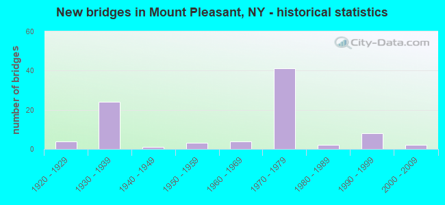
- New bridges - historical statistics
- 41920-1929
- 241930-1939
- 11940-1949
- 31950-1959
- 41960-1969
- 411970-1979
- 21980-1989
- 81990-1999
- 22000-2009
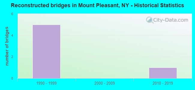
- Reconstructed bridges - Historical Statistics
- 51990-1999
- 02000-2009
- 12010-2019
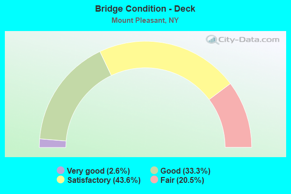
- Bridge Condition - Deck
- 2.6%Very good
- 33.3%Good
- 43.6%Satisfactory
- 20.5%Fair
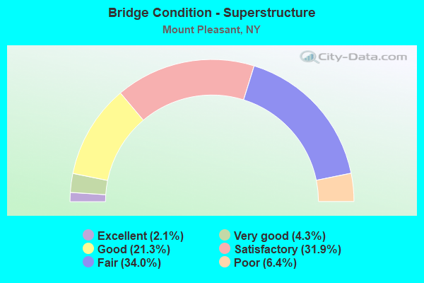
- Bridge Condition - Superstructure
- 2.1%Excellent
- 4.3%Very good
- 21.3%Good
- 31.9%Satisfactory
- 34.0%Fair
- 6.4%Poor
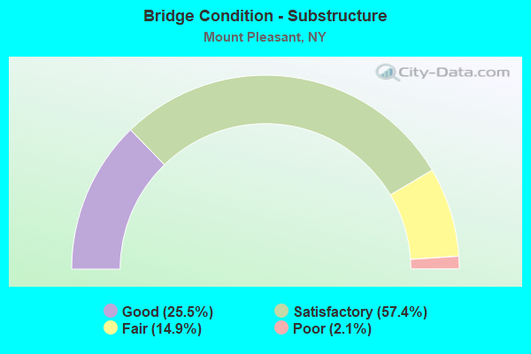
- Bridge Condition - Substructure
- 25.5%Good
- 57.4%Satisfactory
- 14.9%Fair
- 2.1%Poor
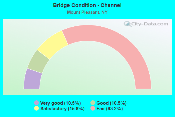
- Bridge Condition - Channel
- 10.5%Very good
- 10.5%Good
- 15.8%Satisfactory
- 63.2%Fair
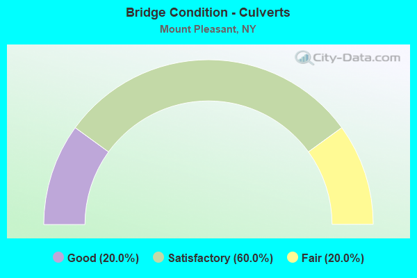
- Bridge Condition - Culverts
- 20.0%Good
- 60.0%Satisfactory
- 20.0%Fair
Find on map >> Show street view
Structure Number: 5500842, Location: 4.7 MI SE OF OSSINING (Lat: 41.124233, Lng: -73.783628), Route carried "on" structure: Ramp Other road , Year Built: 1949, Status: Open, Structure Length: 1.77m (5.81ft), Average Daily Traffic: 2,753 (year 2016), Truck Traffic: 15%, Average Future Daily Traffic: 3,883 (year 2040), Design Load: H 20, Features Intersected: SAW MILL RIVER, Facility Carried by Structure: TO SAWMILL R PKWY
Minimum Vertical Clearance: 30+ m (98+ ft), Kilometerpoint: 0.177, Lanes on structure: 2, Owner: State Highway Agency, Approaching Roadway Width: 7.9m (25.9ft), Skew: 1 degrees, Material/Design: Steel, Design/Construction: Stringer/Multi-beam, Number Of Spans In Main Unit: 3, Length of Maximum Span: 7.0m (23.0ft), Curb or Sidewalk Widths: Left: 0.0m, Right: 1.8m (5.9ft), Curb-To-Curb Width: 7.9m (25.9ft), Out-to-Out Width: 11.1m (36.4ft)
Condition: Deck: Fair, Superstructure: Satisfactory, Substructure: Satisfactory, Channel: Fair, Operating Rating: 54.8 metric tons, Method Used To Determine Operating Rating: Load and Resistance Factor Rating (LRFR) rating reported by rating factor(RF) method using HL-93 loadings, Inventory Rating: 42.1 metric tons, Method Used To Determine Inventory Rating: Load and Resistance Factor Rating (LRFR) rating reported by rating factor(RF) method using HL-93 loadings, Structural Evaluation: Equal to present minimum criteria, Deck Geometry: High priority of replacement, Waterway Adequacy: Equal to present minimum criteria, Approach Roadway Alignment: Better than present minimum criteria, Length Of Structure Improvement: 1.76m (5.77ft), Designated Inspection Frequency: Every 24 months, Inspection Date: May 2020, Bridge Improvement Cost: $822,000, Roadway Improvement Cost: $481,000, Total Project Cost: $1,304,000 ( Estimate for 2021), Deck Structure Type: Concrete Cast-file-Place, Wearing Surface/Protective System: Wearing Surface: Bituminous, Membrane: Other
Find on map >> Show street view
Structure Number: 5500859, Location: 1.6 MI E JCT RTS SMRP+TSP (Lat: 41.124875, Lng: -73.786889), Route carried "on" structure: Other road 987D, Year Built: 1930, Year Reconstructed: 1995, Status: Posted for load-capacity, Structure Length: 0.88m (2.89ft), Average Daily Traffic: 43,863 (year 2007), Truck Traffic: 1%, Average Future Daily Traffic: 61,877 (year 2040), Design Load: HS 20, Features Intersected: SAW MILL RIVER
Minimum Vertical Clearance: 30+ m (98+ ft), Kilometerpoint: 28.077, Lanes on structure: 4, Base Highway Network: Yes, Owner: State Highway Agency, Approaching Roadway Width: 18.6m (61.0ft), Skew: 23 degrees, Material/Design: Steel, Design/Construction: Stringer/Multi-beam, Number Of Spans In Main Unit: 1, Length of Maximum Span: 8.2m (26.9ft), Curb-To-Curb Width: 18.6m (61.0ft), Out-to-Out Width: 22.6m (74.1ft)
Condition: Deck: Good, Superstructure: Satisfactory, Substructure: Good, Channel: Fair, Operating Rating: 65.3 metric tons, Method Used To Determine Operating Rating: Load Factor (LF), Inventory Rating: 39.0 metric tons, Method Used To Determine Inventory Rating: Load Factor (LF), Structural Evaluation: Equal to present minimum criteria, Deck Geometry: Meets minimum limits, Waterway Adequacy: Meets minimum limits, Approach Roadway Alignment: Equal to present desirable criteria, Length Of Structure Improvement: 0.88m (2.89ft), Designated Inspection Frequency: Every 24 months, Inspection Date: June 2021, Bridge Improvement Cost: $1,519,000, Roadway Improvement Cost: $890,000, Total Project Cost: $2,409,000 ( Estimate for 2021), Deck Structure Type: Concrete Cast-file-Place, Wearing Surface/Protective System: Wearing Surface: Bituminous, Membrane: Other
Find on map >> Show street view
Structure Number: 550201, Location: 2.2 MI S JCT RTS BRP+TSP (Lat: 41.074539, Lng: -73.775189), Route carried "on" structure: County highway , Year Built: 1931, Status: Open, Structure Length: 1.68m (5.51ft), Average Daily Traffic: 5,071 (year 2015), Truck Traffic: 4%, Average Future Daily Traffic: 6,274 (year 2040), Features Intersected: 987G 987G87011005, RTE 9, Facility Carried by Structure: LEGION DRIVE
Minimum Vertical Clearance: 30+ m (98+ ft), Kilometerpoint: 0.740, Lanes on structure: 2, Lanes under structure: 4, Owner: State Highway Agency, Approaching Roadway Width: 7.6m (24.9ft), Material/Design: Concrete, Design/Construction: Frame, Number Of Spans In Main Unit: 1, Length of Maximum Span: 14.9m (48.9ft), Curb or Sidewalk Widths: Left: 1.7m (5.6ft), Right: 1.5m (4.9ft), Curb-To-Curb Width: 7.6m (24.9ft), Out-to-Out Width: 12.1m (39.7ft)
Condition: Deck: Good, Superstructure: Good, Substructure: Good, Operating Rating: 57.0 metric tons, Method Used To Determine Operating Rating: Field evaluation and documented engineering judgment, Inventory Rating: 23.3 metric tons, Method Used To Determine Inventory Rating: Field evaluation and documented engineering judgment, Structural Evaluation: Somewhat better than minimum adequacy, Deck Geometry: High priority of replacement, Underclear: High priority of corrective action, Approach Roadway Alignment: Equal to present minimum criteria, Length Of Structure Improvement: 1.67m (5.48ft), Designated Inspection Frequency: Every 24 months, Inspection Date: October 2020, Bridge Improvement Cost: $592,000, Roadway Improvement Cost: $347,000, Total Project Cost: $938,000 ( Estimate for 2021)
Find on map >> Show street view
Structure Number: 5502029, Location: 0.4 MI S JCT RTS BRP+TSP (Lat: 41.097211, Lng: -73.794275), Route carried "on" structure: Other road 987G, Year Built: 1927, Status: Posted for load, Structure Length: 3.14m (10.30ft), Average Daily Traffic: 13,648 (year 2014), Truck Traffic: 1%, Average Future Daily Traffic: 19,253 (year 2040), Features Intersected: MNRR HA LINE
Minimum Vertical Clearance: 30+ m (98+ ft), Kilometerpoint: 3.910, Lanes on structure: 4, Base Highway Network: Yes, Owner: State Highway Agency, Approaching Roadway Width: 13.4m (44.0ft), Skew: 34 degrees, Material/Design: Steel, Design/Construction: Frame, Number Of Spans In Main Unit: 1, Length of Maximum Span: 30.7m (100.7ft), Curb or Sidewalk Widths: Left: 0.7m (2.3ft), Right: 0.7m (2.3ft), Curb-To-Curb Width: 13.4m (44.0ft), Out-to-Out Width: 14.7m (48.2ft)
Condition: Deck: Fair, Superstructure: Poor, Substructure: Fair, Operating Rating: 23.6 metric tons, Method Used To Determine Operating Rating: Load Factor (LF), Inventory Rating: 13.6 metric tons, Method Used To Determine Inventory Rating: Load Factor (LF), Structural Evaluation: High priority of corrective action, Deck Geometry: High priority of replacement, Underclear: Somewhat better than minimum adequacy, Approach Roadway Alignment: Somewhat better than minimum adequacy, Bridge Posting: Required (Relationship of Operating Rating to Maximum Legal Load: > 39.9% below), Length Of Structure Improvement: 3.13m (10.27ft), Designated Inspection Frequency: Every 12 months, Inspection Date: August 2021, Bridge Improvement Cost: $4,200,000, Roadway Improvement Cost: $2,460,000, Total Project Cost: $6,660,000 ( Estimate for 2021), Deck Structure Type: Concrete Cast-file-Place, Wearing Surface/Protective System: Wearing Surface: Bituminous
Find on map >> Show street view
Structure Number: 5502031, Location: 0.2 MI S JCT RTS BRP+TSP (Lat: 41.099464, Lng: -73.797922), Route carried "on" structure: Other road 987F, Year Built: 1972, Year Reconstructed: 2004, Status: Open, Structure Length: 5.67m (18.60ft), Average Daily Traffic: 38,274 (year 2005), Truck Traffic: 2%, Average Future Daily Traffic: 53,992 (year 2040), Design Load: HS 20, Features Intersected: RTE 987G
Minimum Vertical Clearance: 30+ m (98+ ft), Kilometerpoint: 19.887, Lanes on structure: 3, Lanes under structure: 2, Base Highway Network: Yes, Owner: State Highway Agency, Approaching Roadway Width: 11.0m (36.1ft), Skew: 3 degrees, Material/Design: Steel, Design/Construction: Stringer/Multi-beam, Number Of Spans In Main Unit: 3, Length of Maximum Span: 22.6m (74.1ft), Curb or Sidewalk Widths: Left: 0.7m (2.3ft), Right: 0.7m (2.3ft), Curb-To-Curb Width: 11.0m (36.1ft), Out-to-Out Width: 13.8m (45.3ft)
Condition: Deck: Satisfactory, Superstructure: Fair, Substructure: Satisfactory, Operating Rating: 83.5 metric tons, Method Used To Determine Operating Rating: Load Factor (LF), Inventory Rating: 49.9 metric tons, Method Used To Determine Inventory Rating: Load Factor (LF), Structural Evaluation: Somewhat better than minimum adequacy, Deck Geometry: High priority of replacement, Underclear: Meets minimum limits, Approach Roadway Alignment: Equal to present desirable criteria, Length Of Structure Improvement: 5.66m (18.57ft), Designated Inspection Frequency: Every 24 months, Inspection Date: July 2020, Bridge Improvement Cost: $3,181,000, Roadway Improvement Cost: $1,863,000, Total Project Cost: $5,043,000 ( Estimate for 2021), Deck Structure Type: Concrete Cast-file-Place, Wearing Surface/Protective System: Wearing Surface: Bituminous
Find on map >> Show street view
Structure Number: 5502032, Location: 0.2 MI S JCT RTS BRP+TSP (Lat: 41.099272, Lng: -73.797819), Route carried "on" structure: Other road 987F, Year Built: 1972, Status: Open, Structure Length: 5.52m (18.11ft), Average Daily Traffic: 38,274 (year 2005), Truck Traffic: 2%, Average Future Daily Traffic: 53,992 (year 2040), Design Load: HS 20, Features Intersected: RTE 987G
Minimum Vertical Clearance: 30+ m (98+ ft), Kilometerpoint: 19.887, Lanes on structure: 3, Lanes under structure: 2, Base Highway Network: Yes, Owner: State Highway Agency, Approaching Roadway Width: 11.0m (36.1ft), Skew: 3 degrees, Material/Design: Steel, Design/Construction: Stringer/Multi-beam, Number Of Spans In Main Unit: 3, Length of Maximum Span: 20.1m (65.9ft), Curb or Sidewalk Widths: Left: 0.7m (2.3ft), Right: 0.7m (2.3ft), Curb-To-Curb Width: 12.9m (42.3ft), Out-to-Out Width: 13.8m (45.3ft)
Condition: Deck: Satisfactory, Superstructure: Fair, Substructure: Satisfactory, Operating Rating: 91.6 metric tons, Method Used To Determine Operating Rating: Load Factor (LF), Inventory Rating: 54.4 metric tons, Method Used To Determine Inventory Rating: Load Factor (LF), Structural Evaluation: Somewhat better than minimum adequacy, Deck Geometry: High priority of replacement, Underclear: Meets minimum limits, Approach Roadway Alignment: Equal to present desirable criteria, Length Of Structure Improvement: 5.51m (18.08ft), Designated Inspection Frequency: Every 24 months, Inspection Date: October 2021, Bridge Improvement Cost: $3,179,000, Roadway Improvement Cost: $1,862,000, Total Project Cost: $5,041,000 ( Estimate for 2021), Deck Structure Type: Concrete Cast-file-Place, Wearing Surface/Protective System: Wearing Surface: Bituminous
Find on map >> Show street view
Structure Number: 5502059, Location: JCT TSP & SH 141 (Lat: 41.107622, Lng: -73.799208), Route carried "on" structure: Other road 987G, Year Built: 1972, Status: Open, Structure Length: 2.07m (6.79ft), Average Daily Traffic: 88,809 (year 2020), Truck Traffic: 1%, Average Future Daily Traffic: 125,282 (year 2040), Design Load: HS 20, Features Intersected: RTE 141
Minimum Vertical Clearance: 30+ m (98+ ft), Kilometerpoint: 5.213, Lanes on structure: 7, Lanes under structure: 2, Base Highway Network: Yes, Owner: State Highway Agency, Approaching Roadway Width: 25.6m (84.0ft), Skew: 31 degrees, Material/Design: Concrete, Design/Construction: Frame, Number Of Spans In Main Unit: 1, Length of Maximum Span: 16.5m (54.1ft), Curb or Sidewalk Widths: Left: 1.0m (3.3ft), Right: 1.0m (3.3ft), Curb-To-Curb Width: 32.9m (107.9ft), Out-to-Out Width: 36.6m (120.1ft)
Condition: Deck: Satisfactory, Superstructure: Satisfactory, Substructure: Satisfactory, Operating Rating: 84.3 metric tons, Method Used To Determine Operating Rating: Field evaluation and documented engineering judgment, Inventory Rating: 32.7 metric tons, Method Used To Determine Inventory Rating: Field evaluation and documented engineering judgment, Structural Evaluation: Equal to present minimum criteria, Deck Geometry: Better than present minimum criteria, Underclear: Somewhat better than minimum adequacy, Approach Roadway Alignment: Equal to present desirable criteria, Length Of Structure Improvement: 2.07m (6.79ft), Designated Inspection Frequency: Every 24 months, Inspection Date: June 2020, Bridge Improvement Cost: $6,264,000, Roadway Improvement Cost: $3,668,000, Total Project Cost: $9,933,000 ( Estimate for 2021), Wearing Surface/Protective System: Wearing Surface: Monolithic Concrete
Find on map >> Show street view
Structure Number: 5502079, Location: 4.1 MI NE OF TARRYTOWN (Lat: 41.108375, Lng: -73.800303), Route carried "on" structure: Other road 987G, Year Built: 1972, Status: Open, Structure Length: 1.22m (4.00ft), Average Daily Traffic: 58,435 (year 2014), Truck Traffic: 2%, Average Future Daily Traffic: 82,434 (year 2040), Design Load: HS 20, Features Intersected: SAW MILL RIVER
Minimum Vertical Clearance: 30+ m (98+ ft), Kilometerpoint: 5.342, Lanes on structure: 8, Base Highway Network: Yes, Owner: State Highway Agency, Approaching Roadway Width: 29.3m (96.1ft), Skew: 31 degrees, Material/Design: Concrete continuous, Design/Construction: Culvert, Number Of Spans In Main Unit: 3, Length of Maximum Span: 3.9m (12.8ft)
Condition: Channel: Fair, Culverts: Fair, Structural Evaluation: Somewhat better than minimum adequacy, Waterway Adequacy: Meets minimum limits, Approach Roadway Alignment: Better than present minimum criteria, Length Of Structure Improvement: 1.21m (3.97ft), Designated Inspection Frequency: Every 24 months, Inspection Date: August 2020, Bridge Improvement Cost: $1,005,000, Roadway Improvement Cost: $589,000, Total Project Cost: $1,594,000 ( Estimate for 2021), Wearing Surface/Protective System: Wearing Surface: Integral Concrete
Find on map >> Show street view
Structure Number: 550208, Location: 4.1 MI NE OF TARRYTOWN (Lat: 41.108064, Lng: -73.801397), Route carried "on" structure: Other road 987D, Year Built: 1972, Status: Open, Structure Length: 1.22m (4.00ft), Average Daily Traffic: 9,688 (year 2019), Truck Traffic: 2%, Average Future Daily Traffic: 13,666 (year 2040), Design Load: HS 20, Features Intersected: SAW MILL RIVER
Minimum Vertical Clearance: 30+ m (98+ ft), Kilometerpoint: 0.981, Lanes on structure: 2, Owner: State Highway Agency, Approaching Roadway Width: 7.9m (25.9ft), Skew: 1 degrees, Material/Design: Concrete continuous, Design/Construction: Culvert, Number Of Spans In Main Unit: 2, Length of Maximum Span: 5.7m (18.7ft)
Condition: Channel: Fair, Culverts: Good, Inventory Rating: 88.9 metric tons, Method Used To Determine Inventory Rating: Load Factor (LF), Structural Evaluation: Better than present minimum criteria, Waterway Adequacy: Meets minimum limits, Approach Roadway Alignment: Equal to present desirable criteria, Length Of Structure Improvement: 1.21m (3.97ft), Designated Inspection Frequency: Every 24 months, Inspection Date: April 2020, Bridge Improvement Cost: $272,000, Roadway Improvement Cost: $159,000, Total Project Cost: $431,000 ( Estimate for 2021), Wearing Surface/Protective System: Wearing Surface: Bituminous
Find on map >> Show street view
Structure Number: 5502091, Location: JCT OF RTS SMRP+TSP (Lat: 41.109703, Lng: -73.801658), Route carried "on" structure: Other road 987G, Year Built: 1972, Year Reconstructed: 2004, Status: Open, Structure Length: 9.24m (30.31ft), Average Daily Traffic: 29,218 (year 2014), Truck Traffic: 2%, Average Future Daily Traffic: 41,217 (year 2040), Design Load: HS 20+Mod, Features Intersected: 987DX WB, RTE 987D, Ramp
Minimum Vertical Clearance: 30+ m (98+ ft), Kilometerpoint: 5.471, Lanes on structure: 3, Lanes under structure: 8, Base Highway Network: Yes, Owner: State Highway Agency, Approaching Roadway Width: 11.0m (36.1ft), Skew: 1 degrees, Material/Design: Steel, Design/Construction: Stringer/Multi-beam, Number Of Spans In Main Unit: 6, Length of Maximum Span: 15.8m (51.8ft), Curb or Sidewalk Widths: Left: 0.9m (3.0ft), Right: 0.9m (3.0ft), Curb-To-Curb Width: 11.0m (36.1ft), Out-to-Out Width: 13.8m (45.3ft)
Condition: Deck: Good, Superstructure: Satisfactory, Substructure: Good, Operating Rating: 51.5 metric tons, Method Used To Determine Operating Rating: Load and Resistance Factor Rating (LRFR) rating reported by rating factor(RF) method using HL-93 loadings, Inventory Rating: 39.9 metric tons, Method Used To Determine Inventory Rating: Load and Resistance Factor Rating (LRFR) rating reported by rating factor(RF) method using HL-93 loadings, Structural Evaluation: Equal to present minimum criteria, Deck Geometry: High priority of replacement, Underclear: High priority of corrective action, Approach Roadway Alignment: Equal to present desirable criteria, Length Of Structure Improvement: 9.23m (30.28ft), Designated Inspection Frequency: Every 24 months, Critical Feature Inspection Frequency: Every 24 months, Inspection Date: September 2020, Critical Feature Inspection Date: September 2020, Bridge Improvement Cost: $4,848,000, Roadway Improvement Cost: $2,839,000, Total Project Cost: $7,687,000 ( Estimate for 2021), Deck Structure Type: Concrete Cast-file-Place, Wearing Surface/Protective System: Wearing Surface: Bituminous
Find on map >> Show street view
Structure Number: 5502092, Location: JCT OF RTS SMRP+TSP (Lat: 41.109894, Lng: -73.801528), Route carried "on" structure: Other road 987G, Year Built: 1972, Status: Open, Structure Length: 9.24m (30.31ft), Average Daily Traffic: 29,218 (year 2014), Truck Traffic: 2%, Average Future Daily Traffic: 41,217 (year 2040), Design Load: HS 20+Mod, Features Intersected: 987DX WB, RTE 987D, RAMP
Minimum Vertical Clearance: 30+ m (98+ ft), Kilometerpoint: 5.471, Lanes on structure: 3, Lanes under structure: 8, Base Highway Network: Yes, Owner: State Highway Agency, Approaching Roadway Width: 11.0m (36.1ft), Skew: 1 degrees, Material/Design: Steel, Design/Construction: Stringer/Multi-beam, Number Of Spans In Main Unit: 6, Length of Maximum Span: 15.8m (51.8ft), Curb or Sidewalk Widths: Left: 0.9m (3.0ft), Right: 0.9m (3.0ft), Curb-To-Curb Width: 11.0m (36.1ft), Out-to-Out Width: 13.8m (45.3ft)
Condition: Deck: Satisfactory, Superstructure: Fair, Substructure: Fair, Operating Rating: 51.5 metric tons, Method Used To Determine Operating Rating: Load and Resistance Factor Rating (LRFR) rating reported by rating factor(RF) method using HL-93 loadings, Inventory Rating: 39.9 metric tons, Method Used To Determine Inventory Rating: Load and Resistance Factor Rating (LRFR) rating reported by rating factor(RF) method using HL-93 loadings, Structural Evaluation: Somewhat better than minimum adequacy, Deck Geometry: High priority of replacement, Underclear: High priority of corrective action, Approach Roadway Alignment: Equal to present desirable criteria, Length Of Structure Improvement: 9.23m (30.28ft), Designated Inspection Frequency: Every 24 months, Critical Feature Inspection Frequency: Every 24 months, Inspection Date: September 2020, Critical Feature Inspection Date: September 2020, Bridge Improvement Cost: $4,848,000, Roadway Improvement Cost: $2,839,000, Total Project Cost: $7,687,000 ( Estimate for 2021), Deck Structure Type: Concrete Cast-file-Place, Wearing Surface/Protective System: Wearing Surface: Bituminous
Find on map >> Show street view
Structure Number: 5502109, Location: JCT OF RTS SMRP+TSP (Lat: 41.109572, Lng: -73.801797), Route carried "on" structure: Ramp Other road , Year Built: 1969, Status: Open, Structure Length: 8.32m (27.30ft), Average Daily Traffic: 12,381 (year 2019), Truck Traffic: 2%, Average Future Daily Traffic: 17,465 (year 2040), Design Load: HS 20+Mod, Features Intersected: 987DX SB, RTE 987D, RTE, Facility Carried by Structure: RAMPS TO 987G
Minimum Vertical Clearance: 4.67m (15.32ft), Kilometerpoint: 0.724, Lanes on structure: 4, Lanes under structure: 10, Owner: State Highway Agency, Approaching Roadway Width: 7.9m (25.9ft), Skew: 34 degrees, Material/Design: Steel, Design/Construction: Stringer/Multi-beam, Number Of Spans In Main Unit: 4, Length of Maximum Span: 25.2m (82.7ft), Curb-To-Curb Width: 16.4m (53.8ft), Out-to-Out Width: 22.3m (73.2ft)
Condition: Deck: Satisfactory, Superstructure: Fair, Substructure: Satisfactory, Operating Rating: 79.8 metric tons, Method Used To Determine Operating Rating: Load Factor (LF), Inventory Rating: 48.1 metric tons, Method Used To Determine Inventory Rating: Load Factor (LF), Structural Evaluation: Somewhat better than minimum adequacy, Deck Geometry: High priority of corrective action, Underclear: High priority of corrective action, Approach Roadway Alignment: Equal to present desirable criteria, Length Of Structure Improvement: 8.32m (27.30ft), Designated Inspection Frequency: Every 24 months, Inspection Date: April 2021, Bridge Improvement Cost: $7,007,000, Roadway Improvement Cost: $4,103,000, Total Project Cost: $11,111,000 ( Estimate for 2021), Deck Structure Type: Concrete Cast-file-Place, Wearing Surface/Protective System: Wearing Surface: Monolithic Concrete
Find on map >> Show street view
Structure Number: 552385, Location: 1.5 MI S CR40 JCT ON TSP (Lat: 41.123861, Lng: -73.808806), Route carried "on" structure: State highway 987G, Year Built: 1992, Status: Open, Structure Length: 4.60m (15.09ft), Truck Traffic: 2%, Design Load: HS 20, Features Intersected: RTE 117
Minimum Vertical Clearance: 30+ m (98+ ft), Kilometerpoint: 7.208, Lanes on structure: 4, Lanes under structure: 2, Base Highway Network: Yes, Owner: State Highway Agency, Approaching Roadway Width: 21.3m (69.9ft), Skew: 2 degrees, Material/Design: Steel, Design/Construction: Stringer/Multi-beam, Number Of Spans In Main Unit: 1, Length of Maximum Span: 45.7m (149.9ft), Curb-To-Curb Width: 20.1m (65.9ft), Out-to-Out Width: 20.9m (68.6ft)
Condition: Deck: Good, Superstructure: Good, Substructure: Good, Operating Rating: 67.4 metric tons, Method Used To Determine Operating Rating: Load and Resistance Factor Rating (LRFR) rating reported by rating factor(RF) method using HL-93 loadings, Inventory Rating: 51.8 metric tons, Method Used To Determine Inventory Rating: Load and Resistance Factor Rating (LRFR) rating reported by rating factor(RF) method using HL-93 loadings, Structural Evaluation: Better than present minimum criteria, Deck Geometry: Equal to present minimum criteria, Underclear: Somewhat better than minimum adequacy, Approach Roadway Alignment: Equal to present desirable criteria, Length Of Structure Improvement: 4.60m (15.09ft), Designated Inspection Frequency: Every 24 months, Inspection Date: June 2020, Bridge Improvement Cost: $4,857,000, Roadway Improvement Cost: $2,844,000, Total Project Cost: $7,701,000 ( Estimate for 2021), Deck Structure Type: Concrete Cast-file-Place, Wearing Surface/Protective System: Wearing Surface: Integral Concrete, Deck Protection: Epoxy Coated Reinforcing
Find on map >> Show street view
Structure Number: 552386, Location: 1 MI S OF CR40 JCT ON TSP (Lat: 41.130475, Lng: -73.815069), Route carried "on" structure: Ramp Other road , Year Built: 1992, Status: Open, Structure Length: 7.16m (23.49ft), Average Daily Traffic: 11,742 (year 2018), Truck Traffic: 2%, Average Future Daily Traffic: 16,564 (year 2040), Design Load: HS 20, Features Intersected: 987G987G87011050 EB, RTE, Facility Carried by Structure: RAMPFROM TSP NB
Minimum Vertical Clearance: 30+ m (98+ ft), Kilometerpoint: 0.644, Lanes on structure: 1, Lanes under structure: 6, Owner: State Highway Agency, Approaching Roadway Width: 7.0m (23.0ft), Skew: 4 degrees, Material/Design: Steel continuous, Design/Construction: Stringer/Multi-beam, Number Of Spans In Main Unit: 2, Length of Maximum Span: 35.3m (115.8ft), Curb-To-Curb Width: 7.0m (23.0ft), Out-to-Out Width: 7.8m (25.6ft)
Condition: Deck: Good, Superstructure: Good, Substructure: Good, Operating Rating: 73.5 metric tons, Method Used To Determine Operating Rating: Load Factor (LF), Inventory Rating: 44.5 metric tons, Method Used To Determine Inventory Rating: Load Factor (LF), Structural Evaluation: Better than present minimum criteria, Deck Geometry: Equal to present minimum criteria, Underclear: Meets minimum limits, Approach Roadway Alignment: Equal to present desirable criteria, Length Of Structure Improvement: 7.16m (23.49ft), Designated Inspection Frequency: Every 24 months, Inspection Date: June 2020, Bridge Improvement Cost: $2,789,000, Roadway Improvement Cost: $1,633,000, Total Project Cost: $4,422,000 ( Estimate for 2021), Deck Structure Type: Concrete Cast-file-Place, Wearing Surface/Protective System: Wearing Surface: Monolithic Concrete, Deck Protection: Epoxy Coated Reinforcing
Find on map >> Show street view
Structure Number: 100614, Location: JCT RTS 117+9A+TSP (Lat: 41.123678, Lng: -73.809742), Route carried "under" structure: State highway 9A, Year Built: 1936, Structure Length: 0. m, Average Daily Traffic: 31,686 (year 1999), Features Intersected: RTE 9A, RTE 987G, Facility Carried by Structure: RTE 117
Minimum Vertical Clearance: 4.97m (16.31ft), Kilometerpoint: 18.278, Lanes on structure: 5, Lanes under structure: 2, Material/Design: Concrete continuous, Design/Construction: Frame, Length of Maximum Span: 14.3m (46.9ft)
Find on map >> Show street view
Structure Number: 100614, Location: JCT RTS 117+9A+TSP (Lat: 41.123678, Lng: -73.809742), Route carried "under" structure: State highway 987G, Year Built: 1936, Structure Length: 0. m, Average Daily Traffic: 69,204 (year 2002), Features Intersected: RTE 9A, RTE 987G, Facility Carried by Structure: RTE 117
Minimum Vertical Clearance: 4.90m (16.08ft), Kilometerpoint: 7.015, Lanes on structure: 5, Lanes under structure: 3, Material/Design: Concrete continuous, Design/Construction: Frame, Length of Maximum Span: 14.3m (46.9ft)
Find on map >> Show street view
Structure Number: 103715, Location: 2.9 MI E JCT US 9 & SH448 (Lat: 41.109397, Lng: -73.820206), Route carried "under" structure: Other road , Year Built: 1931, Structure Length: 0. m, Average Daily Traffic: 100 (year 2021), Features Intersected: BUTTERMILK HILL R, Facility Carried by Structure: RTE 448
Minimum Vertical Clearance: 4.26m (13.98ft), Kilometerpoint: 0.000, Lanes on structure: 2, Lanes under structure: 1, Material/Design: Concrete, Design/Construction: Arch - Deck, Length of Maximum Span: 9.4m (30.8ft)
Find on map >> Show street view
Structure Number: 103716, Location: JCT RTS 117+9A (Lat: 41.123719, Lng: -73.810533), Route carried "under" structure: State highway 9A, Year Built: 1931, Structure Length: 0. m, Average Daily Traffic: 31,686 (year 1999), Features Intersected: RTE 9A, Facility Carried by Structure: RTE 117
Minimum Vertical Clearance: 6.04m (19.82ft), Kilometerpoint: 18.278, Lanes on structure: 6, Lanes under structure: 2, Material/Design: Concrete, Design/Construction: Frame, Length of Maximum Span: 12.1m (39.7ft)
Find on map >> Show street view
Structure Number: 103799, Location: JCT TSP & RTE 141 (Lat: 41.107239, Lng: -73.800508), Route carried "under" structure: Spur State highway 141, Year Built: 1951, Structure Length: 0. m, Average Daily Traffic: 18,379 (year 2002), Features Intersected: RTE 141, Facility Carried by Structure: RAMP TO TSP SB
Minimum Vertical Clearance: 4.93m (16.17ft), Kilometerpoint: 0.354, Lanes on structure: 2, Lanes under structure: 2, Material/Design: Concrete, Design/Construction: Frame, Length of Maximum Span: 20.1m (65.9ft)
Find on map >> Show street view
Structure Number: 105444, Location: 2.7 MI S JCT RTE 100+TSP (Lat: 41.149733, Lng: -73.825575), Route carried "under" structure: State highway 100, Year Built: 1931, Structure Length: 0. m, Average Daily Traffic: 48,124 (year 2002), Features Intersected: RTE 100, Facility Carried by Structure: RTE 9A
Minimum Vertical Clearance: 5.86m (19.23ft), Kilometerpoint: 4.634, Lanes on structure: 4, Lanes under structure: 2, Material/Design: Concrete, Design/Construction: Frame, Length of Maximum Span: 22.8m (74.8ft)
Find on map >> Show street view
Structure Number: 10705, Location: JCT CR 301 & SH 100 (Lat: 41.090264, Lng: -73.803439), Route carried "under" structure: Other road , Year Built: 1981, Structure Length: 0. m, Average Daily Traffic: 100 (year 2021), Features Intersected: 987F SB, 987F, Facility Carried by Structure: HOSPITAL RD
Minimum Vertical Clearance: 5.94m (19.49ft), Kilometerpoint: 18.664, Lanes on structure: 2, Lanes under structure: 3, Material/Design: Steel, Design/Construction: Stringer/Multi-beam, Length of Maximum Span: 36.5m (119.8ft)
Find on map >> Show street view
Structure Number: 107475, Location: 1.8 MI S JCT RT 133 &TSP (Lat: 41.157667, Lng: -73.818281), Route carried "under" structure: Other road , Year Built: 1994, Structure Length: 0. m, Features Intersected: CHAPPAQUA RD, Facility Carried by Structure: RTE 987G
Minimum Vertical Clearance: 4.52m (14.83ft), Kilometerpoint: 0.000, Lanes on structure: 6, Lanes under structure: 2, Material/Design: Steel, Design/Construction: Stringer/Multi-beam, Length of Maximum Span: 29.2m (95.8ft)
Find on map >> Show street view
Structure Number: 107734, Location: .57 MI N JCT TSP & Rt 117 (Lat: 41.130089, Lng: -73.816022), Route carried "under" structure: State highway 9A, Year Built: 2007, Structure Length: 0. m, Features Intersected: RTE 9A
Minimum Vertical Clearance: 5.08m (16.67ft), Kilometerpoint: 34.095, Lanes on structure: 1, Lanes under structure: 4, Material/Design: Steel, Design/Construction: Stringer/Multi-beam, Length of Maximum Span: 51.0m (167.3ft)
Find on map >> Show street view
Structure Number: 1091031, Location: JCT SH 9A & SH100 & SH141 (Lat: 41.106733, Lng: -73.807031), Route carried "under" structure: Spur State highway , Year Built: 1972, Structure Length: 0. m, Average Daily Traffic: 8,000 (year 1977), Features Intersected: SH100 & 141 RAMPS EB, SH, Facility Carried by Structure: RTE 9A
Minimum Vertical Clearance: 5.23m (17.16ft), Kilometerpoint: 0.097, Lanes on structure: 3, Lanes under structure: 1, Material/Design: Steel, Design/Construction: Stringer/Multi-beam, Length of Maximum Span: 19.2m (63.0ft)
Find on map >> Show street view
Structure Number: 1091032, Location: JCT SH 9A & SH100 & SH141 (Lat: 41.106739, Lng: -73.806839), Route carried "under" structure: Spur State highway , Year Built: 1972, Structure Length: 0. m, Average Daily Traffic: 8,000 (year 1977), Features Intersected: SH100 & 141 RAMPS EB, SH, Facility Carried by Structure: RTE 9A
Minimum Vertical Clearance: 4.80m (15.75ft), Kilometerpoint: 0.000, Lanes on structure: 2, Lanes under structure: 1, Material/Design: Steel, Design/Construction: Stringer/Multi-beam, Length of Maximum Span: 19.2m (63.0ft)
Find on map >> Show street view
Structure Number: 1091071, Location: 0.7 MI E JCT RTS 117+9 (Lat: 41.108525, Lng: -73.844828), Route carried "under" structure: Other road , Year Built: 1970, Structure Length: 0. m, Average Daily Traffic: 378 (year 2019), Truck Traffic: 4%, Features Intersected: SLEEPY HOLLOW RD, POCANT, Facility Carried by Structure: RTE 117
Minimum Vertical Clearance: 4.72m (15.49ft), Kilometerpoint: 0.515, Lanes on structure: 2, Lanes under structure: 2, Material/Design: Steel, Design/Construction: Stringer/Multi-beam, Length of Maximum Span: 29.8m (97.8ft)
Find on map >> Show street view
Structure Number: 1091072, Location: 0.7 MI E JCT RTS 117+9 (Lat: 41.108319, Lng: -73.844936), Route carried "under" structure: Other road , Year Built: 1970, Structure Length: 0. m, Average Daily Traffic: 378 (year 2019), Truck Traffic: 4%, Features Intersected: SLEEPY HOLLOW RD, POCANT, Facility Carried by Structure: RTE 117
Minimum Vertical Clearance: 5.18m (16.99ft), Kilometerpoint: 0.483, Lanes on structure: 2, Lanes under structure: 2, Material/Design: Steel, Design/Construction: Stringer/Multi-beam, Length of Maximum Span: 29.8m (97.8ft)
Find on map >> Show street view
Structure Number: 1091081, Location: 2.7 MI E JCT RTS 117+9 (Lat: 41.121342, Lng: -73.822689), Route carried "under" structure: Spur Other road , Year Built: 1970, Structure Length: 0. m, Average Daily Traffic: 378 (year 2019), Truck Traffic: 4%, Features Intersected: OLD SLEEPY HOLLOW ROAD, Facility Carried by Structure: RTE 117
Minimum Vertical Clearance: 5.33m (17.49ft), Kilometerpoint: 2.993, Lanes on structure: 2, Lanes under structure: 2, Material/Design: Steel, Design/Construction: Stringer/Multi-beam, Length of Maximum Span: 28.0m (91.9ft)
Find on map >> Show street view
Structure Number: 1091082, Location: 2.7 MI E JCT SH117 & US 9 (Lat: 41.121242, Lng: -73.822439), Route carried "under" structure: Spur Other road , Year Built: 1970, Structure Length: 0. m, Average Daily Traffic: 378 (year 2019), Truck Traffic: 4%, Features Intersected: OLD SLEEPY HOLLOW ROAD, Facility Carried by Structure: RTE 117
Minimum Vertical Clearance: 4.77m (15.65ft), Kilometerpoint: 3.025, Lanes on structure: 2, Lanes under structure: 2, Material/Design: Steel, Design/Construction: Stringer/Multi-beam, Length of Maximum Span: 28.3m (92.8ft)
Find on map >> Show street view
Structure Number: 109111, Location: JCT RTE 100+SBP (Lat: 41.095283, Lng: -73.802267), Route carried "under" structure: Other road 987F, Year Built: 1972, Structure Length: 0. m, Average Daily Traffic: 34,850 (year 1978), Features Intersected: 987F 987F87012080 SB, RT, Facility Carried by Structure: RTE 100
Minimum Vertical Clearance: 7.44m (24.41ft), Kilometerpoint: 19.308, Lanes on structure: 4, Lanes under structure: 3, Material/Design: Steel, Design/Construction: Stringer/Multi-beam, Length of Maximum Span: 35.0m (114.8ft)
Find on map >> Show street view
Structure Number: 1091331, Location: JCT S H 117 & U S 9 (Lat: 41.110350, Lng: -73.858381), Route carried "under" structure: US 9, Year Built: 1970, Structure Length: 0. m, Average Daily Traffic: 14,883 (year 2000), Features Intersected: 9 9 87032097 WB, RTE 9, Facility Carried by Structure: RTE 117
Minimum Vertical Clearance: 4.92m (16.14ft), Kilometerpoint: 13.419, Lanes on structure: 1, Lanes under structure: 2, Material/Design: Steel, Design/Construction: Stringer/Multi-beam, Length of Maximum Span: 29.8m (97.8ft)
Find on map >> Show street view
Structure Number: 1091332, Location: JCT S H 117 & U S 9 (Lat: 41.110186, Lng: -73.858406), Route carried "under" structure: US 9, Year Built: 1970, Structure Length: 0. m, Average Daily Traffic: 14,883 (year 2000), Features Intersected: 9 9 87032097 SB, RTE 9, Facility Carried by Structure: RTE 117
Minimum Vertical Clearance: 4.57m (14.99ft), Kilometerpoint: 13.419, Lanes on structure: 2, Lanes under structure: 2, Material/Design: Steel, Design/Construction: Stringer/Multi-beam, Length of Maximum Span: 29.8m (97.8ft)
Find on map >> Show street view
Structure Number: 209104, Location: .2 MI E JCT S H 117/GB RD (Lat: 41.109128, Lng: -73.854533), Route carried "under" structure: State highway 117, Year Built: 1970, Structure Length: 0. m, Average Daily Traffic: 8,734 (year 2002), Features Intersected: RTE 117, Facility Carried by Structure: BRIDLE PATH
Minimum Vertical Clearance: 10.99m (36.06ft), Kilometerpoint: 0.354, Lanes under structure: 5, Material/Design: Steel, Design/Construction: Girder and Floorbeam System, Length of Maximum Span: 64.6m (211.9ft)
Find on map >> Show street view
Structure Number: 209106, Location: .5 MI E JCT SH 117 & US 9 (Lat: 41.107819, Lng: -73.849475), Route carried "under" structure: State highway 117, Year Built: 1970, Structure Length: 0. m, Average Daily Traffic: 8,734 (year 2002), Features Intersected: RTE 117, Facility Carried by Structure: BRIDLE PATH
Minimum Vertical Clearance: 12.99m (42.62ft), Kilometerpoint: 0.788, Lanes under structure: 5, Material/Design: Steel, Design/Construction: Girder and Floorbeam System, Length of Maximum Span: 58.8m (192.9ft)
Find on map >> Show street view
Structure Number: 226571, Location: .8 MILE E OF N TARRYTOWN (Lat: 41.087711, Lng: -73.837478), Route carried "under" structure: Other road , Year Built: 1930, Structure Length: 0. m, Average Daily Traffic: 2,057 (year 2018), Truck Traffic: 4%, Features Intersected: LAKE ROAD, Facility Carried by Structure: KYKUIT HILL ROAD
Minimum Vertical Clearance: 5.33m (17.49ft), Kilometerpoint: 0.000, Lanes on structure: 1, Lanes under structure: 2, Material/Design: Concrete, Design/Construction: Frame, Length of Maximum Span: 11.5m (37.7ft)
Find on map >> Show street view
Structure Number: 250204, Location: .5 MI S JCT TSP & SMRP (Lat: 41.104422, Lng: -73.796339), Route carried "under" structure: Other road , Year Built: 1920, Structure Length: 0. m, Average Daily Traffic: 8,500 (year 2021), Features Intersected: 987F SB, 987F, MNRR HA L, Facility Carried by Structure: CHELSEA STREET
Minimum Vertical Clearance: 5.18m (16.99ft), Kilometerpoint: 16.573, Lanes on structure: 2, Lanes under structure: 4, Material/Design: Steel, Design/Construction: Girder and Floorbeam System, Length of Maximum Span: 25.2m (82.7ft)
Find on map >> Show street view
Structure Number: 5006131, Location: JCT SMRP&RTE 9A HAWTHORNE (Lat: 41.108067, Lng: -73.806383), Route carried "under" structure: State highway 9A, Year Built: 1972, Structure Length: 0. m, Average Daily Traffic: 16,915 (year 1999), Features Intersected: 9A 9A87032103 SB, RTE 9, Facility Carried by Structure: RTE 987D
Minimum Vertical Clearance: 5.05m (16.57ft), Kilometerpoint: 16.460, Lanes on structure: 3, Lanes under structure: 3, Material/Design: Steel, Design/Construction: Stringer/Multi-beam, Length of Maximum Span: 26.2m (86.0ft)
Find on map >> Show street view
Structure Number: 5006132, Location: JCT SMRP&RTE 9A HAWTHORNE (Lat: 41.107989, Lng: -73.806222), Route carried "under" structure: State highway 9A, Year Built: 1972, Structure Length: 0. m, Average Daily Traffic: 16,915 (year 1999), Features Intersected: 9A 9A 870321026 SB, RTE, Facility Carried by Structure: RTE 987D
Minimum Vertical Clearance: 5.08m (16.67ft), Kilometerpoint: 16.460, Lanes on structure: 4, Lanes under structure: 3, Material/Design: Steel, Design/Construction: Stringer/Multi-beam, Length of Maximum Span: 26.5m (86.9ft)
Find on map >> Show street view
Structure Number: 550201, Location: 2.2 MI S JCT RTS BRP+TSP (Lat: 41.074539, Lng: -73.775189), Route carried "under" structure: Other road 987G, Year Built: 1931, Structure Length: 0. m, Average Daily Traffic: 20,520 (year 2021), Features Intersected: 987G 987G87011005, RTE 9, Facility Carried by Structure: LEGION DRIVE
Minimum Vertical Clearance: 5.74m (18.83ft), Kilometerpoint: 0.805, Lanes on structure: 2, Lanes under structure: 2, Material/Design: Concrete, Design/Construction: Frame, Length of Maximum Span: 14.9m (48.9ft)
Find on map >> Show street view
Structure Number: 5502031, Location: 0.2 MI S JCT RTS BRP+TSP (Lat: 41.099464, Lng: -73.797922), Route carried "under" structure: Other road 987G, Year Built: 1972, Structure Length: 0. m, Average Daily Traffic: 5,400 (year 2021), Features Intersected: RTE 987G, Facility Carried by Structure: RTE 987F
Minimum Vertical Clearance: 6.27m (20.57ft), Kilometerpoint: 0.000, Lanes on structure: 3, Lanes under structure: 2, Material/Design: Steel, Design/Construction: Stringer/Multi-beam, Length of Maximum Span: 22.6m (74.1ft)
Find on map >> Show street view
Structure Number: 5502032, Location: 0.2 MI S JCT RTS BRP+TSP (Lat: 41.099272, Lng: -73.797819), Route carried "under" structure: Other road 987G, Year Built: 1972, Structure Length: 0. m, Average Daily Traffic: 5,400 (year 2021), Features Intersected: RTE 987G, Facility Carried by Structure: RTE 987F
Minimum Vertical Clearance: 7.08m (23.23ft), Kilometerpoint: 0.000, Lanes on structure: 3, Lanes under structure: 2, Material/Design: Steel, Design/Construction: Stringer/Multi-beam, Length of Maximum Span: 20.1m (65.9ft)
Find on map >> Show street view
Structure Number: 5502059, Location: JCT TSP & SH 141 (Lat: 41.107622, Lng: -73.799208), Route carried "under" structure: State highway 141, Year Built: 1972, Structure Length: 0. m, Average Daily Traffic: 6,850 (year 1979), Features Intersected: RTE 141, Facility Carried by Structure: RTE 987G
Minimum Vertical Clearance: 5.00m (16.40ft), Kilometerpoint: 16.138, Lanes on structure: 7, Lanes under structure: 2, Material/Design: Concrete, Design/Construction: Frame, Length of Maximum Span: 16.5m (54.1ft)
Find on map >> Show street view
Structure Number: 5502091, Location: JCT OF RTS SMRP+TSP (Lat: 41.109703, Lng: -73.801658), Route carried "under" structure: Other road 987D, Year Built: 1972, Structure Length: 0. m, Average Daily Traffic: 4,320 (year 2021), Features Intersected: 987DX WB, RTE 987D, Ramp, Facility Carried by Structure: RTE 987G
Minimum Vertical Clearance: 5.66m (18.57ft), Kilometerpoint: 0.000, Lanes on structure: 3, Lanes under structure: 2, Material/Design: Steel, Design/Construction: Stringer/Multi-beam, Length of Maximum Span: 15.8m (51.8ft)
Find on map >> Show street view
Structure Number: 5502091, Location: JCT OF RTS SMRP+TSP (Lat: 41.109703, Lng: -73.801658), Route carried "under" structure: Other road , Year Built: 1972, Structure Length: 0. m, Average Daily Traffic: 4,560 (year 2021), Features Intersected: 987DX WB, RTE 987D, Ramp, Facility Carried by Structure: RTE 987G
Minimum Vertical Clearance: 5.23m (17.16ft), Kilometerpoint: 0.000, Lanes on structure: 3, Lanes under structure: 2, Material/Design: Steel, Design/Construction: Stringer/Multi-beam, Length of Maximum Span: 15.8m (51.8ft)
Find on map >> Show street view
Structure Number: 5502092, Location: JCT OF RTS SMRP+TSP (Lat: 41.109894, Lng: -73.801528), Route carried "under" structure: Other road 987D, Year Built: 1972, Structure Length: 0. m, Average Daily Traffic: 4,320 (year 2021), Features Intersected: 987DX WB, RTE 987D, RAMP, Facility Carried by Structure: RTE 987G
Minimum Vertical Clearance: 4.64m (15.22ft), Kilometerpoint: 0.000, Lanes on structure: 3, Lanes under structure: 2, Material/Design: Steel, Design/Construction: Stringer/Multi-beam, Length of Maximum Span: 15.8m (51.8ft)
Find on map >> Show street view
Structure Number: 5502092, Location: JCT OF RTS SMRP+TSP (Lat: 41.109894, Lng: -73.801528), Route carried "under" structure: Other road , Year Built: 1972, Structure Length: 0. m, Average Daily Traffic: 4,560 (year 2021), Features Intersected: 987DX WB, RTE 987D, RAMP, Facility Carried by Structure: RTE 987G
Minimum Vertical Clearance: 4.65m (15.26ft), Kilometerpoint: 0.000, Lanes on structure: 3, Lanes under structure: 2, Material/Design: Steel, Design/Construction: Stringer/Multi-beam, Length of Maximum Span: 15.8m (51.8ft)
Find on map >> Show street view
Structure Number: 5502109, Location: JCT OF RTS SMRP+TSP (Lat: 41.109572, Lng: -73.801797), Route carried "under" structure: Other road 987D, Year Built: 1969, Structure Length: 0. m, Average Daily Traffic: 4,320 (year 2021), Features Intersected: 987DX SB, RTE 987D, RTE, Facility Carried by Structure: RAMPS TO 987G
Minimum Vertical Clearance: 4.92m (16.14ft), Kilometerpoint: 25.422, Lanes on structure: 4, Lanes under structure: 2, Material/Design: Steel, Design/Construction: Stringer/Multi-beam, Length of Maximum Span: 25.2m (82.7ft)
Find on map >> Show street view
Structure Number: 552385, Location: 1.5 MI S CR40 JCT ON TSP (Lat: 41.123861, Lng: -73.808806), Route carried "under" structure: State highway 117, Year Built: 1992, Structure Length: 0. m, Average Daily Traffic: 12,100 (year 1981), Features Intersected: RTE 117, Facility Carried by Structure: RTE 987G
Minimum Vertical Clearance: 5.00m (16.40ft), Kilometerpoint: 4.827, Lanes on structure: 4, Lanes under structure: 2, Material/Design: Steel, Design/Construction: Stringer/Multi-beam, Length of Maximum Span: 45.7m (149.9ft)
Find on map >> Show street view
Structure Number: 552386, Location: 1 MI S OF CR40 JCT ON TSP (Lat: 41.130475, Lng: -73.815069), Route carried "under" structure: Other road 987G, Year Built: 1992, Structure Length: 0. m, Average Daily Traffic: 43,000 (year 2021), Features Intersected: 987G987G87011050 EB, RTE, Facility Carried by Structure: RAMPFROM TSP NB
Minimum Vertical Clearance: 5.61m (18.41ft), Kilometerpoint: 7.884, Lanes on structure: 1, Lanes under structure: 3, Material/Design: Steel continuous, Design/Construction: Stringer/Multi-beam, Length of Maximum Span: 35.3m (115.8ft)
Find on map >> Show street view
Structure Number: 552464, Location: 0.5 MI N OF JCT RT 9 &117 (Lat: 41.118950, Lng: -73.860583), Route carried "under" structure: US 9, Year Built: 1998, Structure Length: 0. m, Average Daily Traffic: 15,567 (year 2000), Features Intersected: RTE 9, Facility Carried by Structure: CROTON AQUD TRAIL
Minimum Vertical Clearance: 9.14m (29.99ft), Kilometerpoint: 16.734, Lanes under structure: 3, Material/Design: Steel, Design/Construction: Truss - Thru, Length of Maximum Span: 48.1m (157.8ft)
Find on map >> Show street view
Structure Number: 771283, Location: 4.3 MI NE N TARRYTOWN (Lat: 41.124219, Lng: -73.782664), Route carried "under" structure: Other road , Year Built: 1938, Structure Length: 0. m, Features Intersected: MARBLE AVENUE, Facility Carried by Structure: MNRR HA LINE
Minimum Vertical Clearance: 3.98m (13.06ft), Kilometerpoint: 0.000, Lanes under structure: 4, Material/Design: Steel, Design/Construction: Girder and Floorbeam System, Length of Maximum Span: 23.4m (76.8ft)