Bridge Statistics for Mount Pleasant, Tennessee (TN)
Condition, Traffic, Stress, Structural Evaluation, Project Costs
- National Bridge Inventory (NBI) Statistics
- 70Number of bridges
- 627ft / 191mTotal length
- $15,550,000Total costs
- 253,903Total average daily traffic
- 26,704Total average daily truck traffic
- National Bridge Inventory (NBI) Registered Bridges for Mount Pleasant
- No street view available for this location
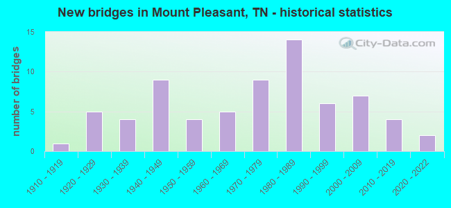
- New bridges - historical statistics
- 11910-1919
- 51920-1929
- 41930-1939
- 91940-1949
- 41950-1959
- 51960-1969
- 91970-1979
- 141980-1989
- 61990-1999
- 72000-2009
- 42010-2019
- 22020-2022

- Reconstructed bridges - Historical Statistics
- 41950-1959
- 11960-1969


- Bridge Condition - Deck
- 2.9%Excellent
- 28.6%Very good
- 20.0%Good
- 2.9%Satisfactory
- 37.1%Fair
- 8.6%Poor

- Bridge Condition - Superstructure
- 2.9%Excellent
- 22.9%Very good
- 20.0%Good
- 5.7%Satisfactory
- 34.3%Fair
- 8.6%Poor
- 5.7%Serious

- Bridge Condition - Substructure
- 2.9%Excellent
- 14.3%Very good
- 20.0%Good
- 8.6%Satisfactory
- 51.4%Fair
- 2.9%Serious

- Bridge Condition - Channel
- 43.6%Very good
- 9.1%Good
- 30.9%Satisfactory
- 12.7%Fair
- 3.6%Poor

- Bridge Condition - Culverts
- 6.9%Good
- 6.9%Satisfactory
- 82.8%Fair
- 3.4%Poor
Find on map >> Show street view
Structure Number: 510A3210001, Location: .1 M W MAURY CO LINE (Lat: 35.526867, Lng: -87.287750), Route carried "on" structure: County highway 321, Year Built: 2004, Status: Open, Structure Length: 2.07m (6.79ft), Average Daily Traffic: 10 (year 2022), Truck Traffic: 2%, Average Future Daily Traffic: 16 (year 2039), Design Load: HS 20, Features Intersected: BIG BIGBY CREEK
Minimum Vertical Clearance: 30+ m (98+ ft), Kilometerpoint: 0.026, Lanes on structure: 2, Owner: County Highway Agency, Approaching Roadway Width: 6.1m (20.0ft), Material/Design: Prestressed concrete continuous, Design/Construction: Box Beam or Girders - Single/Spread, Number Of Spans In Main Unit: 2, Length of Maximum Span: 10.4m (34.1ft), Curb-To-Curb Width: 6.7m (22.0ft), Out-to-Out Width: 7.4m (24.3ft)
Condition: Deck: Good, Superstructure: Very good, Substructure: Satisfactory, Channel: Very good, Operating Rating: 61.2 metric tons, Method Used To Determine Operating Rating: Load Factor (LF), Inventory Rating: 32.4 metric tons, Method Used To Determine Inventory Rating: Load Factor (LF), Structural Evaluation: Equal to present minimum criteria, Deck Geometry: Somewhat better than minimum adequacy, Waterway Adequacy: Equal to present desirable criteria, Approach Roadway Alignment: Equal to present minimum criteria, Designated Inspection Frequency: Every 24 months, Inspection Date: June 2021, Deck Structure Type: Concrete Cast-file-Place, Wearing Surface/Protective System: Wearing Surface: Monolithic Concrete, Deck Protection: Epoxy Coated Reinforcing
Find on map >> Show street view
Structure Number: 60009490001, Location: 4 M. S. MT. PLEASANT. (Lat: 35.482433, Lng: -87.218883), Route carried "on" structure: County highway 949, Year Built: 1962, Status: Open, Structure Length: 1.22m (4.00ft), Average Daily Traffic: 860 (year 2020), Truck Traffic: 3%, Average Future Daily Traffic: 1,600 (year 2040), Design Load: H 15, Features Intersected: DRY BRANCH
Minimum Vertical Clearance: 30+ m (98+ ft), Kilometerpoint: 5.053, Lanes on structure: 2, Owner: County Highway Agency, Approaching Roadway Width: 7.9m (25.9ft), Material/Design: Concrete, Design/Construction: Tee Beam, Number Of Spans In Main Unit: 2, Length of Maximum Span: 5.8m (19.0ft), Curb-To-Curb Width: 6.8m (22.3ft), Out-to-Out Width: 7.4m (24.3ft)
Condition: Deck: Fair, Superstructure: Fair, Substructure: Fair, Channel: Fair, Operating Rating: 36.0 metric tons, Method Used To Determine Operating Rating: Field evaluation and documented engineering judgment, Inventory Rating: 24.3 metric tons, Method Used To Determine Inventory Rating: Field evaluation and documented engineering judgment, Structural Evaluation: Somewhat better than minimum adequacy, Deck Geometry: Meets minimum limits, Waterway Adequacy: Equal to present minimum criteria, Approach Roadway Alignment: Equal to present desirable criteria, Length Of Structure Improvement: 1.22m (4.00ft), Designated Inspection Frequency: Every 24 months, Inspection Date: July 2020, Bridge Improvement Cost: $92,000, Roadway Improvement Cost: $10,000, Total Project Cost: $139,000 ( Estimate for 2020), Deck Structure Type: Concrete Cast-file-Place, Wearing Surface/Protective System: Wearing Surface: Bituminous
Find on map >> Show street view
Structure Number: 60009970001, Location: 10 M. W. COLUMBIA. (Lat: 35.588367, Lng: -87.206633), Route carried "on" structure: County highway 997, Year Built: 1990, Status: Open, Structure Length: 1.16m (3.81ft), Average Daily Traffic: 389 (year 2020), Truck Traffic: 3%, Average Future Daily Traffic: 752 (year 2040), Design Load: HS 20, Features Intersected: DOG CREEK
Minimum Vertical Clearance: 30+ m (98+ ft), Kilometerpoint: 4.828, Lanes on structure: 2, Owner: County Highway Agency, Approaching Roadway Width: 5.5m (18.0ft), Skew: 3 degrees, Material/Design: Concrete continuous, Design/Construction: Culvert, Number Of Spans In Main Unit: 2, Length of Maximum Span: 4.6m (15.1ft), Curb-To-Curb Width: 6.7m (22.0ft), Out-to-Out Width: 7.8m (25.6ft)
Condition: Channel: Very good, Culverts: Good, Operating Rating: 89.1 metric tons, Method Used To Determine Operating Rating: Load Factor (LF), Inventory Rating: 32.4 metric tons, Method Used To Determine Inventory Rating: Load Factor (LF), Structural Evaluation: Better than present minimum criteria, Deck Geometry: Meets minimum limits, Waterway Adequacy: Equal to present minimum criteria, Approach Roadway Alignment: Equal to present minimum criteria, Length Of Structure Improvement: 1.16m (3.81ft), Designated Inspection Frequency: Every 24 months, Inspection Date: July 2020, Bridge Improvement Cost: $78,000, Roadway Improvement Cost: $8,000, Total Project Cost: $118,000 ( Estimate for 2020), Deck Structure Type: Concrete Cast-file-Place, Wearing Surface/Protective System: Wearing Surface: Monolithic Concrete
Find on map >> Show street view
Structure Number: 60009970003, Location: 10.5 M. SW. COLUMBIA. (Lat: 35.570667, Lng: -87.212750), Route carried "on" structure: County highway 997, Year Built: 1997, Status: Open, Structure Length: 5.00m (16.40ft), Average Daily Traffic: 389 (year 2020), Truck Traffic: 3%, Average Future Daily Traffic: 752 (year 2040), Design Load: HS 20, Features Intersected: BIGBY CREEK
Minimum Vertical Clearance: 30+ m (98+ ft), Kilometerpoint: 2.591, Lanes on structure: 2, Owner: County Highway Agency, Approaching Roadway Width: 7.0m (23.0ft), Material/Design: Prestressed concrete continuous, Design/Construction: Box Beam or Girders - Single/Spread, Number Of Spans In Main Unit: 3, Length of Maximum Span: 18.9m (62.0ft), Curb-To-Curb Width: 6.6m (21.7ft), Out-to-Out Width: 7.8m (25.6ft)
Condition: Deck: Very good, Superstructure: Fair, Substructure: Fair, Channel: Very good, Operating Rating: 44.1 metric tons, Method Used To Determine Operating Rating: Assigned rating based on Load Factor Design (LFD) reported in metric tons, Inventory Rating: 32.4 metric tons, Method Used To Determine Inventory Rating: Assigned rating based on Load Factor Design (LFD) reported in metric tons, Structural Evaluation: Somewhat better than minimum adequacy, Deck Geometry: Meets minimum limits, Waterway Adequacy: Equal to present minimum criteria, Approach Roadway Alignment: Equal to present desirable criteria, Length Of Structure Improvement: 5.00m (16.40ft), Designated Inspection Frequency: Every 24 months, Inspection Date: July 2020, Bridge Improvement Cost: $280,000, Roadway Improvement Cost: $29,000, Total Project Cost: $421,000 ( Estimate for 2020), Deck Structure Type: Concrete Precast Panels, Wearing Surface/Protective System: Wearing Surface: Monolithic Concrete, Deck Protection: Epoxy Coated Reinforcing
Find on map >> Show street view
Structure Number: 60018400001, Location: 2 M. SW. MT. PLEASANT. (Lat: 35.518833, Lng: -87.237067), Route carried "on" structure: County highway 1840, Year Built: 1975, Status: Open, Structure Length: 5.52m (18.11ft), Average Daily Traffic: 1,523 (year 2020), Truck Traffic: 6%, Average Future Daily Traffic: 2,704 (year 2040), Features Intersected: BIG BIGBY CREEK
Minimum Vertical Clearance: 30+ m (98+ ft), Kilometerpoint: 4.603, Lanes on structure: 2, Owner: County Highway Agency, Approaching Roadway Width: 9.1m (29.9ft), Material/Design: Prestressed concrete, Design/Construction: Stringer/Multi-beam, Number Of Spans In Main Unit: 3, Length of Maximum Span: 18.9m (62.0ft), Curb-To-Curb Width: 9.3m (30.5ft), Out-to-Out Width: 9.9m (32.5ft)
Condition: Deck: Good, Superstructure: Good, Substructure: Good, Channel: Satisfactory, Operating Rating: 44.1 metric tons, Method Used To Determine Operating Rating: Field evaluation and documented engineering judgment, Inventory Rating: 32.4 metric tons, Method Used To Determine Inventory Rating: Field evaluation and documented engineering judgment, Structural Evaluation: Better than present minimum criteria, Deck Geometry: Somewhat better than minimum adequacy, Waterway Adequacy: Equal to present minimum criteria, Approach Roadway Alignment: Equal to present desirable criteria, Designated Inspection Frequency: Every 24 months, Inspection Date: July 2020, Deck Structure Type: Concrete Cast-file-Place, Wearing Surface/Protective System: Wearing Surface: Bituminous
Find on map >> Show street view
Structure Number: 60018400003, Location: 3 M. SW. MT. PLEASANT. (Lat: 35.525300, Lng: -87.265067), Route carried "on" structure: County highway 1840, Year Built: 2000, Status: Open, Structure Length: 2.26m (7.41ft), Average Daily Traffic: 427 (year 2020), Truck Traffic: 3%, Average Future Daily Traffic: 768 (year 2040), Design Load: HS 20, Features Intersected: BRANCH
Minimum Vertical Clearance: 30+ m (98+ ft), Kilometerpoint: 1.915, Lanes on structure: 2, Owner: County Highway Agency, Approaching Roadway Width: 7.9m (25.9ft), Skew: 3 degrees, Material/Design: Concrete continuous, Design/Construction: Culvert, Number Of Spans In Main Unit: 4, Length of Maximum Span: 4.6m (15.1ft), Curb-To-Curb Width: 8.5m (27.9ft), Out-to-Out Width: 10.2m (33.5ft)
Condition: Channel: Very good, Culverts: Fair, Operating Rating: 44.1 metric tons, Method Used To Determine Operating Rating: Assigned rating based on Load Factor Design (LFD) reported in metric tons, Inventory Rating: 32.4 metric tons, Method Used To Determine Inventory Rating: Assigned rating based on Load Factor Design (LFD) reported in metric tons, Structural Evaluation: Somewhat better than minimum adequacy, Deck Geometry: Somewhat better than minimum adequacy, Waterway Adequacy: Equal to present minimum criteria, Approach Roadway Alignment: Equal to present desirable criteria, Designated Inspection Frequency: Every 24 months, Inspection Date: July 2020
Find on map >> Show street view
Structure Number: 60018400005, Location: 4 M. W. MT. PLEASANT. (Lat: 35.526400, Lng: -87.273567), Route carried "on" structure: County highway 1840, Year Built: 1999, Status: Open, Structure Length: 5.40m (17.72ft), Average Daily Traffic: 427 (year 2020), Truck Traffic: 3%, Average Future Daily Traffic: 768 (year 2040), Design Load: HS 20+Mod, Features Intersected: BIG BIGBY CREEK
Minimum Vertical Clearance: 30+ m (98+ ft), Kilometerpoint: 1.127, Lanes on structure: 2, Owner: County Highway Agency, Approaching Roadway Width: 8.0m (26.2ft), Skew: 6 degrees, Material/Design: Concrete continuous, Design/Construction: Stringer/Multi-beam, Number Of Spans In Main Unit: 3, Length of Maximum Span: 18.0m (59.1ft), Curb-To-Curb Width: 8.0m (26.2ft), Out-to-Out Width: 8.7m (28.5ft)
Condition: Deck: Satisfactory, Superstructure: Good, Substructure: Good, Channel: Very good, Operating Rating: 44.1 metric tons, Method Used To Determine Operating Rating: Assigned rating based on Load Factor Design (LFD) reported in metric tons, Inventory Rating: 32.4 metric tons, Method Used To Determine Inventory Rating: Assigned rating based on Load Factor Design (LFD) reported in metric tons, Structural Evaluation: Better than present minimum criteria, Deck Geometry: Somewhat better than minimum adequacy, Waterway Adequacy: Equal to present minimum criteria, Approach Roadway Alignment: Equal to present desirable criteria, Designated Inspection Frequency: Every 24 months, Inspection Date: July 2020, Deck Structure Type: Concrete Cast-file-Place, Wearing Surface/Protective System: Wearing Surface: Bituminous
Find on map >> Show street view
Structure Number: 60019010003, Location: 5 M. S. WILLIAMSPORT. (Lat: 35.618533, Lng: -87.208267), Route carried "on" structure: County highway 1901, Year Built: 1987, Status: Open, Structure Length: 1.71m (5.61ft), Average Daily Traffic: 171 (year 2020), Truck Traffic: 3%, Average Future Daily Traffic: 560 (year 2040), Design Load: HS 20, Features Intersected: BEARD BRANCH
Minimum Vertical Clearance: 30+ m (98+ ft), Kilometerpoint: 7.483, Lanes on structure: 2, Owner: County Highway Agency, Approaching Roadway Width: 7.6m (24.9ft), Skew: 1 degrees, Material/Design: Concrete continuous, Design/Construction: Culvert, Number Of Spans In Main Unit: 3, Length of Maximum Span: 4.6m (15.1ft), Curb-To-Curb Width: 8.1m (26.6ft), Out-to-Out Width: 9.1m (29.9ft)
Condition: Channel: Very good, Culverts: Fair, Operating Rating: 89.1 metric tons, Method Used To Determine Operating Rating: Load Factor (LF), Inventory Rating: 32.4 metric tons, Method Used To Determine Inventory Rating: Load Factor (LF), Structural Evaluation: Somewhat better than minimum adequacy, Deck Geometry: Somewhat better than minimum adequacy, Waterway Adequacy: Somewhat better than minimum adequacy, Approach Roadway Alignment: Equal to present desirable criteria, Length Of Structure Improvement: 1.71m (5.61ft), Designated Inspection Frequency: Every 24 months, Inspection Date: July 2020, Bridge Improvement Cost: $253,000, Roadway Improvement Cost: $26,000, Total Project Cost: $380,000 ( Estimate for 2020), Deck Structure Type: Concrete Cast-file-Place, Wearing Surface/Protective System: Wearing Surface: Bituminous
Find on map >> Show street view
Structure Number: 600A3180001, Location: 3 M. E. MT. PLEASANT. (Lat: 35.533700, Lng: -87.146450), Route carried "on" structure: County highway 1890, Year Built: 1940, Status: Open, Structure Length: 1.21m (3.97ft), Average Daily Traffic: 520 (year 2020), Truck Traffic: 4%, Average Future Daily Traffic: 864 (year 2040), Features Intersected: ISBELL BRANCH
Minimum Vertical Clearance: 30+ m (98+ ft), Kilometerpoint: 0.161, Lanes on structure: 2, Owner: County Highway Agency, Approaching Roadway Width: 5.5m (18.0ft), Skew: 3 degrees, Material/Design: Concrete, Design/Construction: Tee Beam, Number Of Spans In Main Unit: 1, Length of Maximum Span: 11.6m (38.1ft), Curb-To-Curb Width: 4.9m (16.1ft), Out-to-Out Width: 5.3m (17.4ft)
Condition: Deck: Fair, Superstructure: Fair, Substructure: Fair, Channel: Satisfactory, Operating Rating: 40.5 metric tons, Method Used To Determine Operating Rating: Load Factor (LF), Inventory Rating: 24.3 metric tons, Method Used To Determine Inventory Rating: Load Factor (LF), Structural Evaluation: Somewhat better than minimum adequacy, Deck Geometry: High priority of replacement, Waterway Adequacy: Equal to present minimum criteria, Approach Roadway Alignment: Equal to present desirable criteria, Length Of Structure Improvement: 1.21m (3.97ft), Designated Inspection Frequency: Every 24 months, Inspection Date: July 2020, Bridge Improvement Cost: $157,000, Roadway Improvement Cost: $16,000, Total Project Cost: $236,000 ( Estimate for 2020), Deck Structure Type: Concrete Cast-file-Place, Wearing Surface/Protective System: Wearing Surface: Bituminous
Find on map >> Show street view
Structure Number: 600A3380001, Location: 4. M. SE. MT. PLEASANT. (Lat: 35.494300, Lng: -87.147217), Route carried "on" structure: County highway 338, Year Built: 2002, Status: Open, Structure Length: 0.91m (2.99ft), Average Daily Traffic: 450 (year 2022), Truck Traffic: 2%, Average Future Daily Traffic: 720 (year 2040), Design Load: HS 20+Mod, Features Intersected: TERRAPIN BRANCH
Minimum Vertical Clearance: 30+ m (98+ ft), Kilometerpoint: 0.079, Lanes on structure: 2, Owner: County Highway Agency, Approaching Roadway Width: 6.7m (22.0ft), Skew: 3 degrees, Material/Design: Concrete continuous, Design/Construction: Culvert, Number Of Spans In Main Unit: 2, Length of Maximum Span: 3.7m (12.1ft), Curb-To-Curb Width: 7.9m (25.9ft), Out-to-Out Width: 9.6m (31.5ft)
Condition: Channel: Very good, Culverts: Fair, Operating Rating: 44.1 metric tons, Method Used To Determine Operating Rating: Assigned rating based on Load Factor Design (LFD) reported in metric tons, Inventory Rating: 32.4 metric tons, Method Used To Determine Inventory Rating: Assigned rating based on Load Factor Design (LFD) reported in metric tons, Structural Evaluation: Somewhat better than minimum adequacy, Waterway Adequacy: Equal to present desirable criteria, Approach Roadway Alignment: Equal to present desirable criteria, Designated Inspection Frequency: Every 24 months, Inspection Date: July 2020, Deck Structure Type: Concrete Cast-file-Place, Wearing Surface/Protective System: Wearing Surface: Gravel
Find on map >> Show street view
Structure Number: 600A3530001, Location: 3.5 M. S. MT. PLEASANT. (Lat: 35.472717, Lng: -87.214000), Route carried "on" structure: County highway 353, Year Built: 1936, Status: Posted for load, Structure Length: 1.34m (4.40ft), Average Daily Traffic: 90 (year 2022), Truck Traffic: 2%, Average Future Daily Traffic: 144 (year 2040), Design Load: H 15, Features Intersected: DRY CREEK
Minimum Vertical Clearance: 30+ m (98+ ft), Kilometerpoint: 0.132, Lanes on structure: 2, Owner: County Highway Agency, Approaching Roadway Width: 5.5m (18.0ft), Skew: 1 degrees, Material/Design: Concrete continuous, Design/Construction: Culvert, Number Of Spans In Main Unit: 2, Length of Maximum Span: 6.1m (20.0ft), Curb-To-Curb Width: 5.1m (16.7ft), Out-to-Out Width: 5.5m (18.0ft)
Condition: Channel: Fair, Culverts: Fair, Operating Rating: 27.0 metric tons, Method Used To Determine Operating Rating: Load Factor (LF), Inventory Rating: 16.2 metric tons, Method Used To Determine Inventory Rating: Load Factor (LF), Structural Evaluation: Somewhat better than minimum adequacy, Deck Geometry: High priority of corrective action, Waterway Adequacy: Somewhat better than minimum adequacy, Approach Roadway Alignment: Equal to present minimum criteria, Bridge Posting: Required (Relationship of Operating Rating to Maximum Legal Load: 0.1 - 9.9% below), Length Of Structure Improvement: 1.34m (4.40ft), Designated Inspection Frequency: Every 24 months, Inspection Date: July 2020, Bridge Improvement Cost: $102,000, Roadway Improvement Cost: $11,000, Total Project Cost: $154,000 ( Estimate for 2020), Deck Structure Type: Concrete Cast-file-Place, Wearing Surface/Protective System: Wearing Surface: Gravel
Find on map >> Show street view
Structure Number: 600A3540001, Location: 4 M. S. MT. PLEASANT. (Lat: 35.482133, Lng: -87.236800), Route carried "on" structure: County highway 354, Year Built: 1945, Status: Open, Structure Length: 0.98m (3.22ft), Average Daily Traffic: 440 (year 2022), Truck Traffic: 2%, Average Future Daily Traffic: 704 (year 2040), Design Load: H 10, Features Intersected: BRANCH
Minimum Vertical Clearance: 30+ m (98+ ft), Kilometerpoint: 1.838, Lanes on structure: 2, Owner: County Highway Agency, Approaching Roadway Width: 5.5m (18.0ft), Skew: 4 degrees, Material/Design: Concrete continuous, Design/Construction: Culvert, Number Of Spans In Main Unit: 2, Length of Maximum Span: 3.0m (9.8ft), Curb-To-Curb Width: 5.6m (18.4ft), Out-to-Out Width: 6.2m (20.3ft)
Condition: Channel: Satisfactory, Culverts: Fair, Operating Rating: 37.8 metric tons, Method Used To Determine Operating Rating: Load Factor (LF), Inventory Rating: 22.5 metric tons, Method Used To Determine Inventory Rating: Load Factor (LF), Structural Evaluation: Somewhat better than minimum adequacy, Deck Geometry: High priority of replacement, Waterway Adequacy: Somewhat better than minimum adequacy, Approach Roadway Alignment: Equal to present desirable criteria, Length Of Structure Improvement: 0.98m (3.22ft), Designated Inspection Frequency: Every 24 months, Inspection Date: July 2020, Bridge Improvement Cost: $101,000, Roadway Improvement Cost: $11,000, Total Project Cost: $152,000 ( Estimate for 2020), Deck Structure Type: Concrete Cast-file-Place, Wearing Surface/Protective System: Wearing Surface: Bituminous
Find on map >> Show street view
Structure Number: 600A3580001, Location: 4 M S OF MT PLEASANT (Lat: 35.483200, Lng: -87.242483), Route carried "on" structure: County highway 358, Year Built: 1916, Status: Posted for load, Structure Length: 4.42m (14.50ft), Average Daily Traffic: 140 (year 2022), Truck Traffic: 2%, Average Future Daily Traffic: 224 (year 2040), Features Intersected: BIG BIGBY BRANCH
Minimum Vertical Clearance: 30+ m (98+ ft), Kilometerpoint: 0.681, Lanes on structure: 1, Owner: County Highway Agency, Approaching Roadway Width: 5.8m (19.0ft), Skew: 3 degrees, Material/Design: Concrete, Design/Construction: Arch - Deck, Number Of Spans In Main Unit: 5, Length of Maximum Span: 9.1m (29.9ft), Curb-To-Curb Width: 3.7m (12.1ft), Out-to-Out Width: 4.2m (13.8ft)
Condition: Deck: Poor, Superstructure: Serious, Substructure: Serious, Channel: Poor, Operating Rating: 21.6 metric tons, Method Used To Determine Operating Rating: Field evaluation and documented engineering judgment, Inventory Rating: 4.5 metric tons, Method Used To Determine Inventory Rating: Field evaluation and documented engineering judgment, Structural Evaluation: High priority of replacement, Deck Geometry: High priority of replacement, Waterway Adequacy: Somewhat better than minimum adequacy, Approach Roadway Alignment: Equal to present minimum criteria, Bridge Posting: Required (Relationship of Operating Rating to Maximum Legal Load: 10.0 - 19.9% below), Length Of Structure Improvement: 5.41m (17.75ft), Designated Inspection Frequency: Every 24 months, Inspection Date: July 2020, Bridge Improvement Cost: $986,000, Roadway Improvement Cost: $99,000, Total Project Cost: $1,480,000 ( Estimate for 2020), Deck Structure Type: Concrete Cast-file-Place, Wearing Surface/Protective System: Wearing Surface: Bituminous
Find on map >> Show street view
Structure Number: 600A3580003, Location: 4 M. S. MT. PLEASANT. (Lat: 35.486717, Lng: -87.238950), Route carried "on" structure: County highway 358, Year Built: 1964, Status: Open, Structure Length: 1.28m (4.20ft), Average Daily Traffic: 140 (year 2022), Truck Traffic: 2%, Average Future Daily Traffic: 224 (year 2040), Design Load: H 15, Features Intersected: BRANCH
Minimum Vertical Clearance: 30+ m (98+ ft), Kilometerpoint: 1.180, Lanes on structure: 2, Owner: County Highway Agency, Approaching Roadway Width: 4.9m (16.1ft), Skew: 1 degrees, Material/Design: Concrete continuous, Design/Construction: Culvert, Number Of Spans In Main Unit: 2, Length of Maximum Span: 5.8m (19.0ft), Curb-To-Curb Width: 5.0m (16.4ft), Out-to-Out Width: 5.6m (18.4ft)
Condition: Channel: Satisfactory, Culverts: Fair, Operating Rating: 45.9 metric tons, Method Used To Determine Operating Rating: Load Factor (LF), Inventory Rating: 27.9 metric tons, Method Used To Determine Inventory Rating: Load Factor (LF), Structural Evaluation: Somewhat better than minimum adequacy, Deck Geometry: High priority of replacement, Waterway Adequacy: Somewhat better than minimum adequacy, Approach Roadway Alignment: Equal to present desirable criteria, Length Of Structure Improvement: 1.28m (4.20ft), Designated Inspection Frequency: Every 24 months, Inspection Date: July 2020, Bridge Improvement Cost: $127,000, Roadway Improvement Cost: $13,000, Total Project Cost: $191,000 ( Estimate for 2020), Deck Structure Type: Concrete Cast-file-Place, Wearing Surface/Protective System: Wearing Surface: Bituminous
Find on map >> Show street view
Structure Number: 600A3680001, Location: 4 M. SW. MT. PLEASANT. (Lat: 35.515217, Lng: -87.265783), Route carried "on" structure: County highway 368, Year Built: 1984, Status: Open, Structure Length: 1.40m (4.59ft), Average Daily Traffic: 50 (year 2022), Truck Traffic: 2%, Average Future Daily Traffic: 80 (year 2040), Design Load: HS 20, Features Intersected: DOG BRANCH
Minimum Vertical Clearance: 30+ m (98+ ft), Kilometerpoint: 4.345, Lanes on structure: 2, Owner: County Highway Agency, Approaching Roadway Width: 6.1m (20.0ft), Skew: 4 degrees, Material/Design: Concrete continuous, Design/Construction: Culvert, Number Of Spans In Main Unit: 2, Length of Maximum Span: 4.6m (15.1ft), Curb-To-Curb Width: 6.7m (22.0ft), Out-to-Out Width: 7.8m (25.6ft)
Condition: Channel: Very good, Culverts: Fair, Operating Rating: 58.5 metric tons, Method Used To Determine Operating Rating: Load Factor (LF), Inventory Rating: 32.4 metric tons, Method Used To Determine Inventory Rating: Load Factor (LF), Structural Evaluation: Somewhat better than minimum adequacy, Deck Geometry: Somewhat better than minimum adequacy, Waterway Adequacy: Equal to present minimum criteria, Approach Roadway Alignment: Equal to present minimum criteria, Designated Inspection Frequency: Every 24 months, Inspection Date: July 2020, Deck Structure Type: Concrete Cast-file-Place, Wearing Surface/Protective System: Wearing Surface: Gravel
Find on map >> Show street view
Structure Number: 600A3720001, Location: 4.2 M. SW. MT. PLEASANT. (Lat: 35.519783, Lng: -87.266983), Route carried "on" structure: County highway 372, Year Built: 1940, Status: Open, Structure Length: 1.28m (4.20ft), Average Daily Traffic: 70 (year 2022), Truck Traffic: 2%, Average Future Daily Traffic: 112 (year 2040), Design Load: H 10, Features Intersected: DOG BRANCH
Minimum Vertical Clearance: 30+ m (98+ ft), Kilometerpoint: 0.708, Lanes on structure: 2, Owner: County Highway Agency, Approaching Roadway Width: 4.9m (16.1ft), Skew: 4 degrees, Material/Design: Concrete continuous, Design/Construction: Culvert, Number Of Spans In Main Unit: 2, Length of Maximum Span: 4.6m (15.1ft), Curb-To-Curb Width: 5.2m (17.1ft), Out-to-Out Width: 5.6m (18.4ft)
Condition: Channel: Satisfactory, Culverts: Satisfactory, Operating Rating: 45.4 metric tons, Method Used To Determine Operating Rating: Load Factor (LF), Inventory Rating: 26.1 metric tons, Method Used To Determine Inventory Rating: Load Factor (LF), Structural Evaluation: Equal to present minimum criteria, Deck Geometry: High priority of corrective action, Waterway Adequacy: Meets minimum limits, Approach Roadway Alignment: Equal to present minimum criteria, Length Of Structure Improvement: 1.28m (4.20ft), Designated Inspection Frequency: Every 24 months, Inspection Date: July 2020, Bridge Improvement Cost: $94,000, Roadway Improvement Cost: $10,000, Total Project Cost: $142,000 ( Estimate for 2020), Deck Structure Type: Concrete Cast-file-Place, Wearing Surface/Protective System: Wearing Surface: Bituminous
Find on map >> Show street view
Structure Number: 600A3750001, Location: 3 M. SW. MT. PLEASANT. (Lat: 35.527550, Lng: -87.261167), Route carried "on" structure: County highway 375, Year Built: 2014, Status: Open, Structure Length: 3.66m (12.01ft), Average Daily Traffic: 130 (year 2022), Truck Traffic: 2%, Average Future Daily Traffic: 208 (year 2040), Design Load: HL 93, Features Intersected: W. FORK BIG BIGBY CREEK
Minimum Vertical Clearance: 30+ m (98+ ft), Kilometerpoint: 0.291, Lanes on structure: 2, Owner: County Highway Agency, Approaching Roadway Width: 5.5m (18.0ft), Material/Design: Concrete, Design/Construction: Box Beam or Girders - Single/Spread, Number Of Spans In Main Unit: 3, Length of Maximum Span: 18.3m (60.0ft), Curb-To-Curb Width: 7.3m (24.0ft), Out-to-Out Width: 8.0m (26.2ft)
Condition: Deck: Very good, Superstructure: Very good, Substructure: Very good, Channel: Very good, Operating Rating: 44.1 metric tons, Method Used To Determine Operating Rating: Assigned ratings based on Load and Resistance Factor Design (LRFD) reported by rating factor (RF) using HL93 loadings, Inventory Rating: 32.4 metric tons, Method Used To Determine Inventory Rating: Assigned ratings based on Load and Resistance Factor Design (LRFD) reported by rating factor (RF) using HL93 loadings, Structural Evaluation: Equal to present desirable criteria, Deck Geometry: Somewhat better than minimum adequacy, Waterway Adequacy: Equal to present desirable criteria, Approach Roadway Alignment: Equal to present desirable criteria, Designated Inspection Frequency: Every 24 months, Inspection Date: July 2020, Deck Structure Type: Concrete Cast-file-Place, Wearing Surface/Protective System: Wearing Surface: Monolithic Concrete
Find on map >> Show street view
Structure Number: 600A3750003, Location: 3 M. W. MT. PLEASANT (Lat: 35.534700, Lng: -87.258583), Route carried "on" structure: County highway 375, Year Built: 1989, Status: Open, Structure Length: 1.22m (4.00ft), Average Daily Traffic: 130 (year 2022), Truck Traffic: 2%, Average Future Daily Traffic: 208 (year 2040), Design Load: HS 20, Features Intersected: LONG BRANCH
Minimum Vertical Clearance: 30+ m (98+ ft), Kilometerpoint: 1.481, Lanes on structure: 2, Owner: County Highway Agency, Approaching Roadway Width: 4.9m (16.1ft), Skew: 3 degrees, Material/Design: Concrete continuous, Design/Construction: Culvert, Number Of Spans In Main Unit: 2, Length of Maximum Span: 4.6m (15.1ft), Curb-To-Curb Width: 6.7m (22.0ft), Out-to-Out Width: 7.8m (25.6ft)
Condition: Channel: Very good, Culverts: Fair, Operating Rating: 87.3 metric tons, Method Used To Determine Operating Rating: Load Factor (LF), Inventory Rating: 32.4 metric tons, Method Used To Determine Inventory Rating: Load Factor (LF), Structural Evaluation: Somewhat better than minimum adequacy, Deck Geometry: Meets minimum limits, Waterway Adequacy: Equal to present minimum criteria, Approach Roadway Alignment: Equal to present minimum criteria, Length Of Structure Improvement: 1.22m (4.00ft), Designated Inspection Frequency: Every 24 months, Inspection Date: July 2020, Bridge Improvement Cost: $75,000, Roadway Improvement Cost: $8,000, Total Project Cost: $113,000 ( Estimate for 2020), Deck Structure Type: Concrete Cast-file-Place, Wearing Surface/Protective System: Wearing Surface: Gravel
Find on map >> Show street view
Structure Number: 600A3780001, Location: 2 M. S. MT. PLEASANT. (Lat: 35.503400, Lng: -87.189283), Route carried "on" structure: County highway 378, Year Built: 2000, Status: Open, Structure Length: 1.12m (3.67ft), Average Daily Traffic: 90 (year 2022), Truck Traffic: 2%, Average Future Daily Traffic: 144 (year 2040), Design Load: HS 20, Features Intersected: SUGAR CREEK
Minimum Vertical Clearance: 30+ m (98+ ft), Kilometerpoint: 0.296, Lanes on structure: 2, Owner: County Highway Agency, Approaching Roadway Width: 6.1m (20.0ft), Skew: 4 degrees, Material/Design: Concrete, Design/Construction: Culvert, Number Of Spans In Main Unit: 2, Length of Maximum Span: 3.7m (12.1ft), Curb-To-Curb Width: 6.7m (22.0ft), Out-to-Out Width: 8.4m (27.6ft)
Condition: Channel: Very good, Culverts: Fair, Operating Rating: 44.1 metric tons, Method Used To Determine Operating Rating: Assigned rating based on Load Factor Design (LFD) reported in metric tons, Inventory Rating: 32.4 metric tons, Method Used To Determine Inventory Rating: Assigned rating based on Load Factor Design (LFD) reported in metric tons, Structural Evaluation: Somewhat better than minimum adequacy, Deck Geometry: Somewhat better than minimum adequacy, Waterway Adequacy: Equal to present desirable criteria, Approach Roadway Alignment: Equal to present desirable criteria, Designated Inspection Frequency: Every 24 months, Inspection Date: July 2020, Deck Structure Type: Concrete Cast-file-Place, Wearing Surface/Protective System: Wearing Surface: Other
Find on map >> Show street view
Structure Number: 600A3810001, Location: ARROW MINES RD@MTPLEASANT (Lat: 35.527867, Lng: -87.207983), Route carried "on" structure: City street 381, Year Built: 1930, Year Reconstructed: 1960, Status: Open, Structure Length: 1.58m (5.18ft), Average Daily Traffic: 860 (year 2022), Truck Traffic: 2%, Average Future Daily Traffic: 1,376 (year 2041), Design Load: H 15, Features Intersected: SUGAR CREEK
Minimum Vertical Clearance: 30+ m (98+ ft), Kilometerpoint: 0.163, Lanes on structure: 2, Owner: City or Municipal Highway Agency, Approaching Roadway Width: 6.7m (22.0ft), Material/Design: Concrete, Design/Construction: Tee Beam, Number Of Spans In Main Unit: 2, Length of Maximum Span: 7.6m (24.9ft), Curb-To-Curb Width: 7.9m (25.9ft), Out-to-Out Width: 8.4m (27.6ft)
Condition: Deck: Fair, Superstructure: Poor, Substructure: Fair, Channel: Satisfactory, Operating Rating: 36.0 metric tons, Method Used To Determine Operating Rating: Field evaluation and documented engineering judgment, Inventory Rating: 24.3 metric tons, Method Used To Determine Inventory Rating: Field evaluation and documented engineering judgment, Structural Evaluation: Meets minimum limits, Deck Geometry: Somewhat better than minimum adequacy, Waterway Adequacy: Equal to present minimum criteria, Approach Roadway Alignment: Equal to present desirable criteria, Length Of Structure Improvement: 1.58m (5.18ft), Designated Inspection Frequency: Every 24 months, Inspection Date: July 2020, Bridge Improvement Cost: $255,000, Roadway Improvement Cost: $26,000, Total Project Cost: $383,000 ( Estimate for 2021), Deck Structure Type: Concrete Cast-file-Place, Wearing Surface/Protective System: Wearing Surface: Bituminous
Find on map >> Show street view
Structure Number: 600A3920001, Location: 2.5 M. E. MT. PLEASANT. (Lat: 35.523017, Lng: -87.157717), Route carried "on" structure: County highway 285, Year Built: 1987, Status: Open, Structure Length: 1.83m (6.00ft), Average Daily Traffic: 150 (year 2022), Truck Traffic: 2%, Average Future Daily Traffic: 240 (year 2040), Design Load: HS 20, Features Intersected: SCOTTS CREEK
Minimum Vertical Clearance: 30+ m (98+ ft), Kilometerpoint: 0.138, Lanes on structure: 2, Owner: County Highway Agency, Approaching Roadway Width: 6.4m (21.0ft), Skew: 1 degrees, Material/Design: Concrete continuous, Design/Construction: Culvert, Number Of Spans In Main Unit: 3, Length of Maximum Span: 5.5m (18.0ft), Curb-To-Curb Width: 6.7m (22.0ft), Out-to-Out Width: 7.8m (25.6ft)
Condition: Channel: Very good, Culverts: Fair, Operating Rating: 71.1 metric tons, Method Used To Determine Operating Rating: Load Factor (LF), Inventory Rating: 32.4 metric tons, Method Used To Determine Inventory Rating: Load Factor (LF), Structural Evaluation: Somewhat better than minimum adequacy, Deck Geometry: Meets minimum limits, Waterway Adequacy: Equal to present minimum criteria, Approach Roadway Alignment: Equal to present desirable criteria, Length Of Structure Improvement: 1.83m (6.00ft), Designated Inspection Frequency: Every 24 months, Inspection Date: July 2020, Bridge Improvement Cost: $88,000, Roadway Improvement Cost: $9,000, Total Project Cost: $133,000 ( Estimate for 2020), Deck Structure Type: Concrete Cast-file-Place, Wearing Surface/Protective System: Wearing Surface: Monolithic Concrete
Find on map >> Show street view
Structure Number: 600A3930001, Location: 2 M. E. MT. PLEASANT. (Lat: 35.543300, Lng: -87.170517), Route carried "on" structure: County highway 393, Year Built: 2006, Status: Open, Structure Length: 2.00m (6.56ft), Average Daily Traffic: 130 (year 2022), Truck Traffic: 2%, Average Future Daily Traffic: 208 (year 2040), Design Load: HS 20+Mod, Features Intersected: QUALITY CREEK
Minimum Vertical Clearance: 30+ m (98+ ft), Kilometerpoint: 2.091, Lanes on structure: 2, Owner: County Highway Agency, Approaching Roadway Width: 6.7m (22.0ft), Material/Design: Prestressed concrete, Design/Construction: Box Beam or Girders - Single/Spread, Number Of Spans In Main Unit: 1, Length of Maximum Span: 19.4m (63.6ft), Curb-To-Curb Width: 7.3m (24.0ft), Out-to-Out Width: 8.0m (26.2ft)
Condition: Deck: Very good, Superstructure: Very good, Substructure: Good, Channel: Very good, Operating Rating: 44.1 metric tons, Method Used To Determine Operating Rating: Assigned rating based on Load Factor Design (LFD) reported in metric tons, Inventory Rating: 32.4 metric tons, Method Used To Determine Inventory Rating: Assigned rating based on Load Factor Design (LFD) reported in metric tons, Structural Evaluation: Better than present minimum criteria, Waterway Adequacy: Equal to present desirable criteria, Approach Roadway Alignment: Equal to present desirable criteria, Designated Inspection Frequency: Every 24 months, Inspection Date: July 2020, Deck Structure Type: Concrete Cast-file-Place, Wearing Surface/Protective System: Wearing Surface: Monolithic Concrete
Find on map >> Show street view
Structure Number: 600A4080001, Location: 3 M. N. MT. PLEASANT. (Lat: 35.585483, Lng: -87.184133), Route carried "on" structure: County highway 408, Year Built: 1930, Status: Posted for load, Structure Length: 4.85m (15.91ft), Average Daily Traffic: 260 (year 2022), Truck Traffic: 2%, Average Future Daily Traffic: 416 (year 2040), Design Load: H 15, Features Intersected: BIG BIGBY CREEK
Minimum Vertical Clearance: 30+ m (98+ ft), Kilometerpoint: 2.110, Lanes on structure: 2, Owner: County Highway Agency, Approaching Roadway Width: 4.9m (16.1ft), Material/Design: Concrete, Design/Construction: Tee Beam, Number Of Spans In Main Unit: 4, Length of Maximum Span: 12.2m (40.0ft), Curb-To-Curb Width: 5.3m (17.4ft), Out-to-Out Width: 6.0m (19.7ft)
Condition: Deck: Poor, Superstructure: Serious, Substructure: Fair, Channel: Poor, Operating Rating: 36.0 metric tons, Method Used To Determine Operating Rating: Field evaluation and documented engineering judgment, Inventory Rating: 16.2 metric tons, Method Used To Determine Inventory Rating: Field evaluation and documented engineering judgment, Structural Evaluation: High priority of corrective action, Deck Geometry: High priority of replacement, Waterway Adequacy: Equal to present minimum criteria, Approach Roadway Alignment: Better than present minimum criteria, Bridge Posting: Required (Relationship of Operating Rating to Maximum Legal Load: 0.1 - 9.9% below), Length Of Structure Improvement: 4.85m (15.91ft), Designated Inspection Frequency: Every 24 months, Inspection Date: July 2020, Bridge Improvement Cost: $404,000, Roadway Improvement Cost: $41,000, Total Project Cost: $607,000 ( Estimate for 2020), Deck Structure Type: Concrete Cast-file-Place, Wearing Surface/Protective System: Wearing Surface: Monolithic Concrete
Find on map >> Show street view
Structure Number: 600A4090001, Location: 2 M. NW. MT. PLEASANT. (Lat: 35.550783, Lng: -87.238983), Route carried "on" structure: County highway 409, Year Built: 1966, Status: Open, Structure Length: 0.73m (2.40ft), Average Daily Traffic: 100 (year 2022), Truck Traffic: 2%, Average Future Daily Traffic: 160 (year 2040), Features Intersected: CAMP BRANCH
Minimum Vertical Clearance: 30+ m (98+ ft), Kilometerpoint: 0.401, Lanes on structure: 2, Owner: County Highway Agency, Approaching Roadway Width: 7.6m (24.9ft), Material/Design: Concrete, Design/Construction: Culvert, Number Of Spans In Main Unit: 1, Length of Maximum Span: 7.0m (23.0ft), Curb-To-Curb Width: 7.4m (24.3ft), Out-to-Out Width: 8.6m (28.2ft)
Condition: Channel: Satisfactory, Culverts: Fair, Operating Rating: 40.5 metric tons, Method Used To Determine Operating Rating: Load Factor (LF), Inventory Rating: 24.3 metric tons, Method Used To Determine Inventory Rating: Load Factor (LF), Structural Evaluation: Somewhat better than minimum adequacy, Deck Geometry: Equal to present minimum criteria, Waterway Adequacy: Equal to present minimum criteria, Approach Roadway Alignment: Equal to present desirable criteria, Length Of Structure Improvement: 0.73m (2.40ft), Designated Inspection Frequency: Every 24 months, Inspection Date: July 2020, Bridge Improvement Cost: $1,000, Roadway Improvement Cost: $1,000, Total Project Cost: $2,000 ( Estimate for 2020), Deck Structure Type: Concrete Cast-file-Place, Wearing Surface/Protective System: Wearing Surface: Gravel
Find on map >> Show street view
Structure Number: 600A4090003, Location: 4 M. NW. MT. PLEASANT. (Lat: 35.575567, Lng: -87.248417), Route carried "on" structure: County highway 409, Year Built: 1983, Status: Open, Structure Length: 1.13m (3.71ft), Average Daily Traffic: 100 (year 2022), Truck Traffic: 2%, Average Future Daily Traffic: 160 (year 2040), Design Load: HS 20, Features Intersected: DOG BRANCH
Minimum Vertical Clearance: 30+ m (98+ ft), Kilometerpoint: 3.449, Lanes on structure: 2, Owner: County Highway Agency, Approaching Roadway Width: 6.1m (20.0ft), Skew: 3 degrees, Material/Design: Concrete continuous, Design/Construction: Culvert, Number Of Spans In Main Unit: 2, Length of Maximum Span: 4.6m (15.1ft), Curb-To-Curb Width: 6.7m (22.0ft), Out-to-Out Width: 8.0m (26.2ft)
Condition: Channel: Very good, Culverts: Satisfactory, Operating Rating: 64.8 metric tons, Method Used To Determine Operating Rating: Load Factor (LF), Inventory Rating: 38.9 metric tons, Method Used To Determine Inventory Rating: Load Factor (LF), Structural Evaluation: Equal to present minimum criteria, Deck Geometry: Somewhat better than minimum adequacy, Waterway Adequacy: Equal to present minimum criteria, Approach Roadway Alignment: Equal to present desirable criteria, Designated Inspection Frequency: Every 24 months, Inspection Date: July 2020, Deck Structure Type: Concrete Cast-file-Place, Wearing Surface/Protective System: Wearing Surface: Gravel
Find on map >> Show street view
Structure Number: 600A4120001, Location: 3 M. NW. MT. PLEASANT. (Lat: 35.577933, Lng: -87.238117), Route carried "on" structure: County highway 412, Year Built: 1940, Status: Open, Structure Length: 1.01m (3.31ft), Average Daily Traffic: 100 (year 2022), Truck Traffic: 2%, Average Future Daily Traffic: 160 (year 2040), Design Load: H 15, Features Intersected: DOG BRANCH
Minimum Vertical Clearance: 30+ m (98+ ft), Kilometerpoint: 1.217, Lanes on structure: 2, Owner: County Highway Agency, Approaching Roadway Width: 4.9m (16.1ft), Skew: 2 degrees, Material/Design: Concrete continuous, Design/Construction: Culvert, Number Of Spans In Main Unit: 2, Length of Maximum Span: 4.0m (13.1ft), Curb-To-Curb Width: 5.6m (18.4ft), Out-to-Out Width: 6.3m (20.7ft)
Condition: Channel: Fair, Culverts: Poor, Operating Rating: 36.0 metric tons, Method Used To Determine Operating Rating: Field evaluation and documented engineering judgment, Inventory Rating: 24.3 metric tons, Method Used To Determine Inventory Rating: Field evaluation and documented engineering judgment, Structural Evaluation: Meets minimum limits, Deck Geometry: Meets minimum limits, Waterway Adequacy: Somewhat better than minimum adequacy, Approach Roadway Alignment: Equal to present minimum criteria, Length Of Structure Improvement: 1.01m (3.31ft), Designated Inspection Frequency: Every 24 months, Inspection Date: July 2020, Bridge Improvement Cost: $70,000, Roadway Improvement Cost: $8,000, Total Project Cost: $106,000 ( Estimate for 2020), Deck Structure Type: Concrete Cast-file-Place, Wearing Surface/Protective System: Wearing Surface: Gravel
Find on map >> Show street view
Structure Number: 600A4130001, Location: 3.0 M. NW. MT. PLEASANT. (Lat: 35.556067, Lng: -87.260283), Route carried "on" structure: County highway 413, Year Built: 1984, Status: Open, Structure Length: 0.82m (2.69ft), Average Daily Traffic: 80 (year 2022), Truck Traffic: 2%, Average Future Daily Traffic: 128 (year 2040), Design Load: HS 20, Features Intersected: CAMP BRANCH
Minimum Vertical Clearance: 30+ m (98+ ft), Kilometerpoint: 0.209, Lanes on structure: 2, Owner: County Highway Agency, Approaching Roadway Width: 6.7m (22.0ft), Skew: 1 degrees, Material/Design: Concrete continuous, Design/Construction: Culvert, Number Of Spans In Main Unit: 2, Length of Maximum Span: 3.7m (12.1ft), Curb-To-Curb Width: 6.7m (22.0ft), Out-to-Out Width: 8.1m (26.6ft)
Condition: Channel: Very good, Culverts: Fair, Operating Rating: 38.7 metric tons, Method Used To Determine Operating Rating: Load Factor (LF), Inventory Rating: 22.5 metric tons, Method Used To Determine Inventory Rating: Load Factor (LF), Structural Evaluation: Somewhat better than minimum adequacy, Deck Geometry: Somewhat better than minimum adequacy, Waterway Adequacy: Equal to present minimum criteria, Approach Roadway Alignment: Equal to present desirable criteria, Length Of Structure Improvement: 0.82m (2.69ft), Designated Inspection Frequency: Every 24 months, Inspection Date: July 2020, Bridge Improvement Cost: $20,000, Roadway Improvement Cost: $3,000, Total Project Cost: $31,000 ( Estimate for 2020), Deck Structure Type: Concrete Cast-file-Place, Wearing Surface/Protective System: Wearing Surface: Monolithic Concrete
Find on map >> Show street view
Structure Number: 600A4130003, Location: 3.5 M. NW. MT. PLEASANT (Lat: 35.556833, Lng: -87.265633), Route carried "on" structure: County highway 413, Year Built: 1984, Status: Open, Structure Length: 0.79m (2.59ft), Average Daily Traffic: 80 (year 2022), Truck Traffic: 2%, Average Future Daily Traffic: 128 (year 2040), Design Load: HS 20, Features Intersected: CAMP BRANCH
Minimum Vertical Clearance: 30+ m (98+ ft), Kilometerpoint: 0.739, Lanes on structure: 2, Owner: County Highway Agency, Approaching Roadway Width: 6.7m (22.0ft), Skew: 3 degrees, Material/Design: Concrete continuous, Design/Construction: Culvert, Number Of Spans In Main Unit: 2, Length of Maximum Span: 3.0m (9.8ft), Curb-To-Curb Width: 6.7m (22.0ft), Out-to-Out Width: 8.1m (26.6ft)
Condition: Channel: Satisfactory, Culverts: Fair, Operating Rating: 42.3 metric tons, Method Used To Determine Operating Rating: Load Factor (LF), Inventory Rating: 26.1 metric tons, Method Used To Determine Inventory Rating: Load Factor (LF), Structural Evaluation: Somewhat better than minimum adequacy, Deck Geometry: Somewhat better than minimum adequacy, Waterway Adequacy: Equal to present minimum criteria, Approach Roadway Alignment: Equal to present minimum criteria, Designated Inspection Frequency: Every 24 months, Inspection Date: July 2020, Deck Structure Type: Concrete Cast-file-Place, Wearing Surface/Protective System: Wearing Surface: Monolithic Concrete
Find on map >> Show street view
Structure Number: 600A4180001, Location: 3 M. N. MT. PLEASANT. (Lat: 35.581317, Lng: -87.225600), Route carried "on" structure: County highway 418, Year Built: 1939, Status: Open, Structure Length: 1.25m (4.10ft), Average Daily Traffic: 90 (year 2022), Truck Traffic: 2%, Average Future Daily Traffic: 144 (year 2040), Design Load: H 15, Features Intersected: DOG BRANCH
Minimum Vertical Clearance: 30+ m (98+ ft), Kilometerpoint: 2.778, Lanes on structure: 1, Owner: County Highway Agency, Approaching Roadway Width: 4.9m (16.1ft), Material/Design: Concrete, Design/Construction: Arch - Deck, Number Of Spans In Main Unit: 1, Length of Maximum Span: 12.2m (40.0ft), Curb-To-Curb Width: 4.8m (15.7ft), Out-to-Out Width: 5.5m (18.0ft)
Condition: Deck: Fair, Superstructure: Fair, Substructure: Fair, Channel: Satisfactory, Operating Rating: 36.0 metric tons, Method Used To Determine Operating Rating: Load Factor (LF), Inventory Rating: 24.3 metric tons, Method Used To Determine Inventory Rating: Load Factor (LF), Structural Evaluation: Somewhat better than minimum adequacy, Deck Geometry: Equal to present desirable criteria, Waterway Adequacy: Equal to present minimum criteria, Approach Roadway Alignment: Equal to present desirable criteria, Length Of Structure Improvement: 1.25m (4.10ft), Designated Inspection Frequency: Every 24 months, Inspection Date: July 2020, Bridge Improvement Cost: $182,000, Roadway Improvement Cost: $19,000, Total Project Cost: $274,000 ( Estimate for 2020), Deck Structure Type: Concrete Cast-file-Place, Wearing Surface/Protective System: Wearing Surface: Gravel
Find on map >> Show street view
Structure Number: 600A4710001, Location: 4.5 M. S. MT. PLEASANT. (Lat: 35.457000, Lng: -87.209517), Route carried "on" structure: County highway 471, Year Built: 2021, Status: Open, Structure Length: 1.22m (4.00ft), Average Daily Traffic: 330 (year 2022), Truck Traffic: 2%, Average Future Daily Traffic: 528 (year 2042), Design Load: HL 93, Features Intersected: BRANCH
Minimum Vertical Clearance: 30+ m (98+ ft), Kilometerpoint: 3.599, Lanes on structure: 2, Owner: County Highway Agency, Approaching Roadway Width: 7.3m (24.0ft), Skew: 4 degrees, Material/Design: Prestressed concrete, Design/Construction: Box Beam or Girders - Multiple, Number Of Spans In Main Unit: 1, Length of Maximum Span: 9.9m (32.5ft), Curb or Sidewalk Widths: Left: 0.4m (1.3ft), Right: 0.4m (1.3ft), Curb-To-Curb Width: 8.5m (27.9ft), Out-to-Out Width: 9.2m (30.2ft)
Condition: Deck: Good, Superstructure: Very good, Substructure: Satisfactory, Channel: Very good, Operating Rating: 42.1 metric tons, Method Used To Determine Operating Rating: Assigned ratings based on Load and Resistance Factor Design (LRFD) reported by rating factor (RF) using HL93 loadings, Inventory Rating: 32.4 metric tons, Method Used To Determine Inventory Rating: Assigned ratings based on Load and Resistance Factor Design (LRFD) reported by rating factor (RF) using HL93 loadings, Structural Evaluation: Equal to present minimum criteria, Deck Geometry: Equal to present minimum criteria, Waterway Adequacy: Equal to present desirable criteria, Approach Roadway Alignment: Equal to present desirable criteria, Designated Inspection Frequency: Every 24 months, Inspection Date: June 2021, Deck Structure Type: Concrete Cast-file-Place, Wearing Surface/Protective System: Wearing Surface: Monolithic Concrete
Find on map >> Show street view
Structure Number: 600A4710003, Location: 4 M. S. MT. PLEASANT. (Lat: 35.470550, Lng: -87.215800), Route carried "on" structure: County highway 471, Year Built: 2011, Status: Open, Structure Length: 0.68m (2.23ft), Average Daily Traffic: 330 (year 2022), Truck Traffic: 2%, Average Future Daily Traffic: 528 (year 2040), Design Load: HL 93, Features Intersected: DRY CREEK
Minimum Vertical Clearance: 30+ m (98+ ft), Kilometerpoint: 5.261, Lanes on structure: 2, Owner: County Highway Agency, Approaching Roadway Width: 6.7m (22.0ft), Skew: 2 degrees, Material/Design: Concrete, Design/Construction: Culvert, Number Of Spans In Main Unit: 2, Length of Maximum Span: 3.0m (9.8ft), Curb-To-Curb Width: 6.7m (22.0ft), Out-to-Out Width: 8.4m (27.6ft)
Condition: Channel: Very good, Culverts: Fair, Operating Rating: 45.4 metric tons, Method Used To Determine Operating Rating: Load Factor (LF), Inventory Rating: 29.2 metric tons, Method Used To Determine Inventory Rating: Load Factor (LF), Structural Evaluation: Somewhat better than minimum adequacy, Deck Geometry: Meets minimum limits, Waterway Adequacy: Equal to present desirable criteria, Approach Roadway Alignment: Equal to present desirable criteria, Length Of Structure Improvement: 0.68m (2.23ft), Designated Inspection Frequency: Every 24 months, Inspection Date: July 2020, Bridge Improvement Cost: $40,000, Roadway Improvement Cost: $5,000, Total Project Cost: $61,000 ( Estimate for 2020), Deck Structure Type: Concrete Cast-file-Place, Wearing Surface/Protective System: Wearing Surface: Monolithic Concrete
Find on map >> Show street view
Structure Number: 60S61990001, Location: 2 M W JCT SR6&SR166 (Lat: 35.554583, Lng: -87.254300), Route carried "on" structure: State highway 166, Year Built: 1953, Status: Open, Structure Length: 1.40m (4.59ft), Average Daily Traffic: 1,032 (year 2020), Truck Traffic: 5%, Average Future Daily Traffic: 1,568 (year 2040), Design Load: HS 20, Features Intersected: CAMP BRANCH
Minimum Vertical Clearance: 30+ m (98+ ft), Kilometerpoint: 18.765, Lanes on structure: 2, Owner: State Highway Agency, Approaching Roadway Width: 7.9m (25.9ft), Skew: 4 degrees, Material/Design: Concrete continuous, Design/Construction: Culvert, Number Of Spans In Main Unit: 3, Length of Maximum Span: 3.0m (9.8ft), Curb-To-Curb Width: 7.7m (25.3ft), Out-to-Out Width: 7.9m (25.9ft)
Condition: Channel: Fair, Culverts: Fair, Operating Rating: 45.0 metric tons, Method Used To Determine Operating Rating: Load Factor (LF), Inventory Rating: 26.1 metric tons, Method Used To Determine Inventory Rating: Load Factor (LF), Structural Evaluation: Somewhat better than minimum adequacy, Deck Geometry: Meets minimum limits, Waterway Adequacy: Equal to present minimum criteria, Approach Roadway Alignment: Equal to present desirable criteria, Length Of Structure Improvement: 1.40m (4.59ft), Designated Inspection Frequency: Every 24 months, Inspection Date: March 2020, Bridge Improvement Cost: $86,000, Roadway Improvement Cost: $9,000, Total Project Cost: $130,000 ( Estimate for 2020)
Find on map >> Show street view
Structure Number: 60S61990003, Location: .6 M W JCT SR6&SR166 (Lat: 35.545617, Lng: -87.235550), Route carried "on" structure: State highway 166, Year Built: 1953, Status: Open, Structure Length: 5.21m (17.09ft), Average Daily Traffic: 1,764 (year 2020), Truck Traffic: 4%, Average Future Daily Traffic: 2,272 (year 2040), Design Load: HS 20, Features Intersected: OVERFLOW BIGBY CREEK
Minimum Vertical Clearance: 30+ m (98+ ft), Kilometerpoint: 16.777, Lanes on structure: 2, Owner: State Highway Agency, Approaching Roadway Width: 7.9m (25.9ft), Material/Design: Concrete, Design/Construction: Tee Beam, Number Of Spans In Main Unit: 6, Length of Maximum Span: 8.8m (28.9ft), Curb-To-Curb Width: 7.3m (24.0ft), Out-to-Out Width: 8.7m (28.5ft)
Condition: Deck: Fair, Superstructure: Fair, Substructure: Fair, Channel: Fair, Operating Rating: 47.7 metric tons, Method Used To Determine Operating Rating: Load Factor (LF), Inventory Rating: 28.8 metric tons, Method Used To Determine Inventory Rating: Load Factor (LF), Structural Evaluation: Somewhat better than minimum adequacy, Deck Geometry: Meets minimum limits, Waterway Adequacy: Equal to present minimum criteria, Approach Roadway Alignment: Equal to present desirable criteria, Length Of Structure Improvement: 5.21m (17.09ft), Designated Inspection Frequency: Every 24 months, Inspection Date: March 2020, Bridge Improvement Cost: $308,000, Roadway Improvement Cost: $31,000, Total Project Cost: $463,000 ( Estimate for 2020), Deck Structure Type: Concrete Cast-file-Place, Wearing Surface/Protective System: Wearing Surface: Bituminous
Find on map >> Show street view
Structure Number: 60S61990005, Location: .5 M W JCT SR6&SR166 (Lat: 35.545533, Lng: -87.234383), Route carried "on" structure: State highway 166, Year Built: 1953, Status: Open, Structure Length: 4.36m (14.30ft), Average Daily Traffic: 1,764 (year 2020), Truck Traffic: 4%, Average Future Daily Traffic: 2,272 (year 2040), Design Load: HS 20, Features Intersected: BIG BIGBY CREEK
Minimum Vertical Clearance: 30+ m (98+ ft), Kilometerpoint: 16.673, Lanes on structure: 2, Owner: State Highway Agency, Approaching Roadway Width: 7.9m (25.9ft), Material/Design: Concrete, Design/Construction: Tee Beam, Number Of Spans In Main Unit: 4, Length of Maximum Span: 13.1m (43.0ft), Curb-To-Curb Width: 7.3m (24.0ft), Out-to-Out Width: 8.7m (28.5ft)
Condition: Deck: Fair, Superstructure: Fair, Substructure: Fair, Channel: Fair, Operating Rating: 41.4 metric tons, Method Used To Determine Operating Rating: Load Factor (LF), Inventory Rating: 25.2 metric tons, Method Used To Determine Inventory Rating: Load Factor (LF), Structural Evaluation: Somewhat better than minimum adequacy, Deck Geometry: Meets minimum limits, Waterway Adequacy: Equal to present minimum criteria, Approach Roadway Alignment: Equal to present desirable criteria, Length Of Structure Improvement: 4.36m (14.30ft), Designated Inspection Frequency: Every 24 months, Inspection Date: March 2020, Bridge Improvement Cost: $273,000, Roadway Improvement Cost: $28,000, Total Project Cost: $410,000 ( Estimate for 2020), Deck Structure Type: Concrete Cast-file-Place, Wearing Surface/Protective System: Wearing Surface: Bituminous
Find on map >> Show street view
Structure Number: 60S62000001, Location: 4 M NW OF LAWRENCE CO LN (Lat: 35.486500, Lng: -87.182700), Route carried "on" structure: State highway 166, Year Built: 1953, Status: Open, Structure Length: 1.74m (5.71ft), Average Daily Traffic: 1,191 (year 2020), Truck Traffic: 5%, Average Future Daily Traffic: 1,600 (year 2040), Design Load: H 15, Features Intersected: SUGAR CREEK
Minimum Vertical Clearance: 30+ m (98+ ft), Kilometerpoint: 6.711, Lanes on structure: 2, Owner: State Highway Agency, Approaching Roadway Width: 7.9m (25.9ft), Skew: 3 degrees, Material/Design: Concrete continuous, Design/Construction: Culvert, Number Of Spans In Main Unit: 3, Length of Maximum Span: 4.6m (15.1ft), Curb-To-Curb Width: 7.7m (25.3ft), Out-to-Out Width: 8.6m (28.2ft)
Condition: Channel: Satisfactory, Culverts: Fair, Operating Rating: 38.7 metric tons, Method Used To Determine Operating Rating: Load Factor (LF), Inventory Rating: 22.5 metric tons, Method Used To Determine Inventory Rating: Load Factor (LF), Structural Evaluation: Somewhat better than minimum adequacy, Deck Geometry: Meets minimum limits, Waterway Adequacy: Equal to present minimum criteria, Approach Roadway Alignment: Equal to present desirable criteria, Length Of Structure Improvement: 1.74m (5.71ft), Designated Inspection Frequency: Every 24 months, Inspection Date: March 2020, Bridge Improvement Cost: $77,000, Roadway Improvement Cost: $8,000, Total Project Cost: $116,000 ( Estimate for 2020), Deck Structure Type: Concrete Cast-file-Place, Wearing Surface/Protective System: Wearing Surface: Bituminous
Find on map >> Show street view
Structure Number: 60S62000003, Location: 2 MI. SE OF MT. PLEASANT (Lat: 35.472017, Lng: -87.179667), Route carried "on" structure: State highway 166, Year Built: 1970, Status: Open, Structure Length: 0.82m (2.69ft), Average Daily Traffic: 1,191 (year 2020), Truck Traffic: 5%, Average Future Daily Traffic: 1,600 (year 2040), Design Load: H 15, Features Intersected: SUGAR CREEK
Minimum Vertical Clearance: 30+ m (98+ ft), Kilometerpoint: 4.989, Lanes on structure: 2, Owner: State Highway Agency, Approaching Roadway Width: 7.9m (25.9ft), Skew: 3 degrees, Material/Design: Concrete continuous, Design/Construction: Culvert, Number Of Spans In Main Unit: 2, Length of Maximum Span: 3.0m (9.8ft), Curb-To-Curb Width: 8.2m (26.9ft), Out-to-Out Width: 8.8m (28.9ft)
Condition: Channel: Good, Culverts: Fair, Operating Rating: 71.1 metric tons, Method Used To Determine Operating Rating: Load Factor (LF), Inventory Rating: 42.3 metric tons, Method Used To Determine Inventory Rating: Load Factor (LF), Structural Evaluation: Somewhat better than minimum adequacy, Deck Geometry: Meets minimum limits, Waterway Adequacy: Better than present minimum criteria, Approach Roadway Alignment: Equal to present minimum criteria, Length Of Structure Improvement: 0.82m (2.69ft), Designated Inspection Frequency: Every 24 months, Inspection Date: March 2020, Bridge Improvement Cost: $42,000, Roadway Improvement Cost: $5,000, Total Project Cost: $64,000 ( Estimate for 2020), Deck Structure Type: Concrete Cast-file-Place, Wearing Surface/Protective System: Wearing Surface: Bituminous
Find on map >> Show street view
Structure Number: 60S62510001, Location: .5 M E JCT SR246&SR247 (Lat: 35.752800, Lng: -86.996833), Route carried "on" structure: State highway 247, Year Built: 2006, Status: Open, Structure Length: 3.32m (10.89ft), Average Daily Traffic: 3,297 (year 2020), Truck Traffic: 3%, Average Future Daily Traffic: 5,275 (year 2042), Design Load: HL 93, Features Intersected: CARTERS CREEK
Minimum Vertical Clearance: 30+ m (98+ ft), Kilometerpoint: 25.283, Lanes on structure: 2, Base Highway Network: Yes, Owner: State Highway Agency, Approaching Roadway Width: 11.7m (38.4ft), Material/Design: Prestressed concrete, Design/Construction: Stringer/Multi-beam, Number Of Spans In Main Unit: 1, Length of Maximum Span: 33.2m (108.9ft), Curb-To-Curb Width: 11.7m (38.4ft), Out-to-Out Width: 12.8m (42.0ft)
Condition: Deck: Good, Superstructure: Very good, Substructure: Good, Channel: Very good, Operating Rating: 44.1 metric tons, Method Used To Determine Operating Rating: Assigned rating based on Load Factor Design (LFD) reported in metric tons, Inventory Rating: 32.4 metric tons, Method Used To Determine Inventory Rating: Assigned rating based on Load Factor Design (LFD) reported in metric tons, Structural Evaluation: Better than present minimum criteria, Deck Geometry: Somewhat better than minimum adequacy, Waterway Adequacy: Equal to present desirable criteria, Approach Roadway Alignment: Equal to present desirable criteria, Designated Inspection Frequency: Every 24 months, Inspection Date: March 2020, Deck Structure Type: Concrete Cast-file-Place, Wearing Surface/Protective System: Wearing Surface: Bituminous
Find on map >> Show street view
Structure Number: 60S62520001, Location: .5 M. SE. MT. PLEASANT (Lat: 35.532417, Lng: -87.202600), Route carried "on" structure: City street 968, Year Built: 1960, Status: Open, Structure Length: 1.49m (4.89ft), Average Daily Traffic: 1,093 (year 2020), Truck Traffic: 3%, Average Future Daily Traffic: 2,000 (year 2040), Design Load: H 15, Features Intersected: SUGAR CREEK
Minimum Vertical Clearance: 30+ m (98+ ft), Kilometerpoint: 4.361, Lanes on structure: 2, Owner: City or Municipal Highway Agency, Approaching Roadway Width: 9.1m (29.9ft), Material/Design: Concrete continuous, Design/Construction: Culvert, Number Of Spans In Main Unit: 3, Length of Maximum Span: 4.6m (15.1ft), Curb-To-Curb Width: 8.6m (28.2ft), Out-to-Out Width: 11.1m (36.4ft)
Condition: Channel: Satisfactory, Culverts: Fair, Operating Rating: 41.4 metric tons, Method Used To Determine Operating Rating: Load Factor (LF), Inventory Rating: 24.3 metric tons, Method Used To Determine Inventory Rating: Load Factor (LF), Structural Evaluation: Somewhat better than minimum adequacy, Deck Geometry: Somewhat better than minimum adequacy, Waterway Adequacy: Equal to present minimum criteria, Approach Roadway Alignment: Equal to present desirable criteria, Length Of Structure Improvement: 1.49m (4.89ft), Designated Inspection Frequency: Every 24 months, Inspection Date: July 2020, Bridge Improvement Cost: $27,000, Roadway Improvement Cost: $3,000, Total Project Cost: $41,000 ( Estimate for 2020), Deck Structure Type: Concrete Cast-file-Place, Wearing Surface/Protective System: Wearing Surface: Bituminous
Find on map >> Show street view
Structure Number: 60S62520003, Location: 3 M. E. MT. PLEASANT (Lat: 35.524033, Lng: -87.158400), Route carried "on" structure: County highway 968, Year Built: 1960, Status: Open, Structure Length: 2.62m (8.60ft), Average Daily Traffic: 1,093 (year 2020), Truck Traffic: 3%, Average Future Daily Traffic: 2,000 (year 2040), Design Load: HS 20, Features Intersected: SCOTTS CREEK
Minimum Vertical Clearance: 30+ m (98+ ft), Kilometerpoint: 0.161, Lanes on structure: 2, Owner: County Highway Agency, Approaching Roadway Width: 9.1m (29.9ft), Skew: 3 degrees, Material/Design: Concrete, Design/Construction: Tee Beam, Number Of Spans In Main Unit: 3, Length of Maximum Span: 8.8m (28.9ft), Curb-To-Curb Width: 8.5m (27.9ft), Out-to-Out Width: 10.5m (34.4ft)
Condition: Deck: Fair, Superstructure: Fair, Substructure: Satisfactory, Channel: Good, Operating Rating: 63.9 metric tons, Method Used To Determine Operating Rating: Load Factor (LF), Inventory Rating: 32.4 metric tons, Method Used To Determine Inventory Rating: Load Factor (LF), Structural Evaluation: Somewhat better than minimum adequacy, Deck Geometry: Somewhat better than minimum adequacy, Waterway Adequacy: Equal to present minimum criteria, Approach Roadway Alignment: Equal to present minimum criteria, Length Of Structure Improvement: 2.62m (8.60ft), Designated Inspection Frequency: Every 24 months, Inspection Date: July 2020, Bridge Improvement Cost: $90,000, Roadway Improvement Cost: $10,000, Total Project Cost: $136,000 ( Estimate for 2020), Deck Structure Type: Concrete Cast-file-Place, Wearing Surface/Protective System: Wearing Surface: Bituminous
Find on map >> Show street view
Structure Number: 60S62530001, Location: 8.5 M. SW. COLUMBIA. (Lat: 35.535367, Lng: -87.147567), Route carried "on" structure: County highway 993, Year Built: 2021, Status: Open, Structure Length: 1.68m (5.51ft), Average Daily Traffic: 1,190 (year 2020), Truck Traffic: 4%, Average Future Daily Traffic: 1,904 (year 2042), Design Load: HL 93, Features Intersected: ISBEL BRANCH
Minimum Vertical Clearance: 30+ m (98+ ft), Kilometerpoint: 8.900, Lanes on structure: 2, Owner: County Highway Agency, Approaching Roadway Width: 6.7m (22.0ft), Skew: 1 degrees, Material/Design: Prestressed concrete, Design/Construction: Box Beam or Girders - Multiple, Number Of Spans In Main Unit: 1, Length of Maximum Span: 15.2m (49.9ft), Curb or Sidewalk Widths: Left: 0.4m (1.3ft), Right: 0.4m (1.3ft), Curb-To-Curb Width: 8.5m (27.9ft), Out-to-Out Width: 9.2m (30.2ft)
Condition: Deck: Excellent, Superstructure: Excellent, Substructure: Excellent, Channel: Very good, Operating Rating: 42.1 metric tons, Method Used To Determine Operating Rating: Assigned ratings based on Load and Resistance Factor Design (LRFD) reported by rating factor (RF) using HL93 loadings, Inventory Rating: 32.4 metric tons, Method Used To Determine Inventory Rating: Assigned ratings based on Load and Resistance Factor Design (LRFD) reported by rating factor (RF) using HL93 loadings, Structural Evaluation: Equal to present desirable criteria, Deck Geometry: Somewhat better than minimum adequacy, Waterway Adequacy: Equal to present desirable criteria, Approach Roadway Alignment: Equal to present desirable criteria, Designated Inspection Frequency: Every 24 months, Inspection Date: August 2021, Deck Structure Type: Concrete Cast-file-Place, Wearing Surface/Protective System: Wearing Surface: Bituminous